SPATIAL DISTRIBUTION OF LANDSLIDES TRIGGERED BY THE WENCHUAN EARTHQUAKE, SICHUAN PROVINCE, CHINA...
25
SPATIAL DISTRIBUTION OF LANDSLIDES TRIGGERED BY THE WENCHUAN EARTHQUAKE, SICHUAN PROVINCE, CHINA Tolga Görüm & Cees J. Van Westen
-
Upload
gordon-cameron -
Category
Documents
-
view
218 -
download
0
Transcript of SPATIAL DISTRIBUTION OF LANDSLIDES TRIGGERED BY THE WENCHUAN EARTHQUAKE, SICHUAN PROVINCE, CHINA...

SPATIAL DISTRIBUTION OF LANDSLIDES TRIGGERED BY THE WENCHUAN EARTHQUAKE, SICHUAN PROVINCE, CHINA
Tolga Görüm & Cees J. Van Westen
OVERVIEW
Global significance of seismically triggered landslidesIntroduction to the 12th May 2008 Wenchuan EarthquakeLandslide Mapping & Spatial Distribution of LandslidesKey findings from the Wenchuan earthquake

EARTHQUAKE TRIGGERED LANDSLIDES
Fatal landslides 2008International Landslide Centre: Landslide DatabaseD. N. Petley
Some notable events:1.1994 North Ridge Earthquake,
California (M=6.7)over 10 000 landslides
2.2005 Kashmir Earthquake, Pakistan (M = 7.6)
over 20 000 landslides

RESEARCH ON EARTHQUAKE-INDUCED LANDSLIDES & FINDINGS
The main underlying assertion in most research on regional patterns of
coseismic landslides is that the landslides cluster in parts of the
landscape can reflect the properties of their triggers, and a
considerable amount of these studies has focused on the relationship
between the seismic parameters (i.e. epicenter, coseismic fault or
ground motion) and landslides, generally addressing the correlation of
landslide intensity with the distance from or to the seismic source
parameters.

WENCHUAN EARTHQUAKE Thrust Oblique
• 30 million people affected• 70,000 dead• 375,000 injured• Direct losses to buildings and
infrastructure of over US$150 billion• 35% of people killed were buried by
landslides• 15% of survivors could not be rescued
because landslides blocked roads
(Mw 7.9)

PRE- AND POST-EARTHQUAKE SATELLITE IMAGE COVERAGE
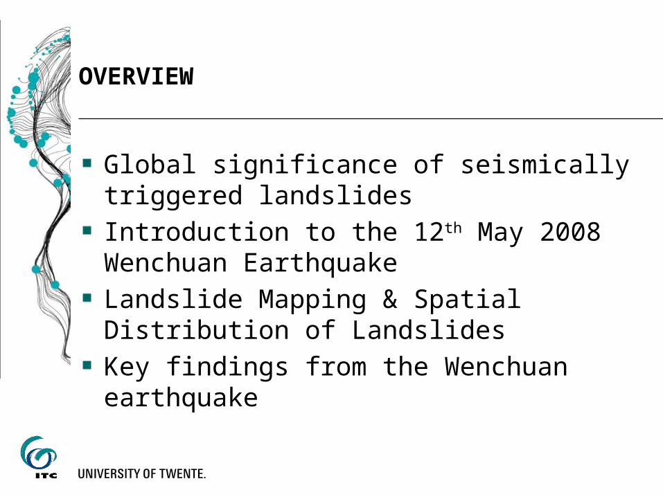
METHODOLOGY

METHODOLOGY

METHODOLOGY
The tone, defined as the relative brightness in a black/white image, or the colour in the false colour composite allowed to differentiate unvegetated areas that are most indicative for recent landslides.
Texture relates to the frequency of tonal change.
Shape or form refers to the geometric aspects of the object in the image
Pattern refers to the spatial arrangement of features and implies a characteristic repetition of certain forms or relationships.

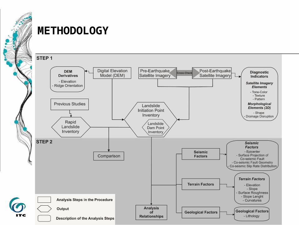
LANDSLIDE INVENTORY
LANDSLIDE INVENTORY
Dai et al., 2011

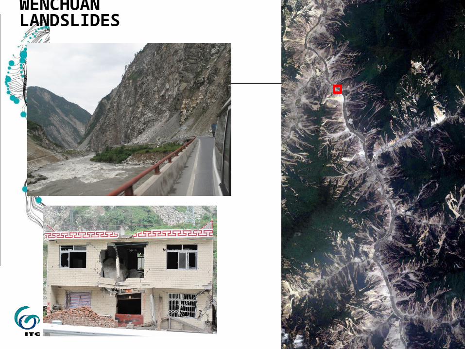
WENCHUAN LANDSLIDES Deep-seated bedrock avalanches & slides
700
1600

WENCHUAN LANDSLIDES Deep-seated bedrock avalanches & slides
Pre-earthquake Post-earthquake

WENCHUAN LANDSLIDES

WENCHUAN LANDSLIDES
WENCHUAN LANDSLIDES

WENCHUAN LANDSLIDES

WENCHUAN LANDSLIDES

17 June
18 Nov
Aggradation of >10 m in Beichuan in 5 months, due to landslide remobilization
Post-earthquake sedimentation – Beichuan
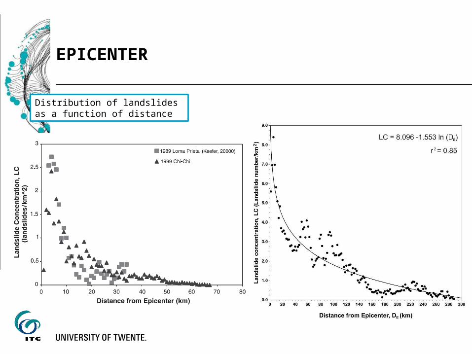
EPICENTER
Distribution of landslides as a function of distance
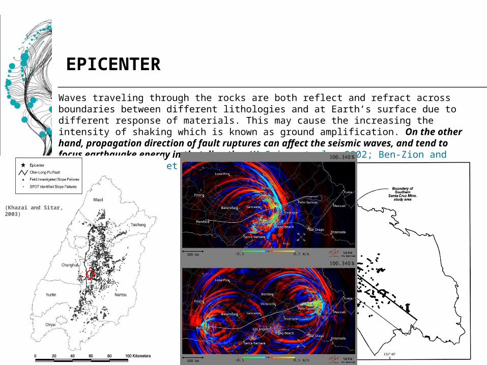
Waves traveling through the rocks are both reflect and refract across boundaries between different lithologies and at Earth’s surface due to different response of materials. This may cause the increasing the intensity of shaking which is known as ground amplification. On the other hand, propagation direction of fault ruptures can affect the seismic waves, and tend to focus earthquake energy in that direction (McGuire et al., 2002; Ben Zion and Shi, 2005; Minster et al., 2006; Dor et al., 2008‐ ).
(Khazai and Sitar, 2003)
(Keefer, 2000)
EPICENTER
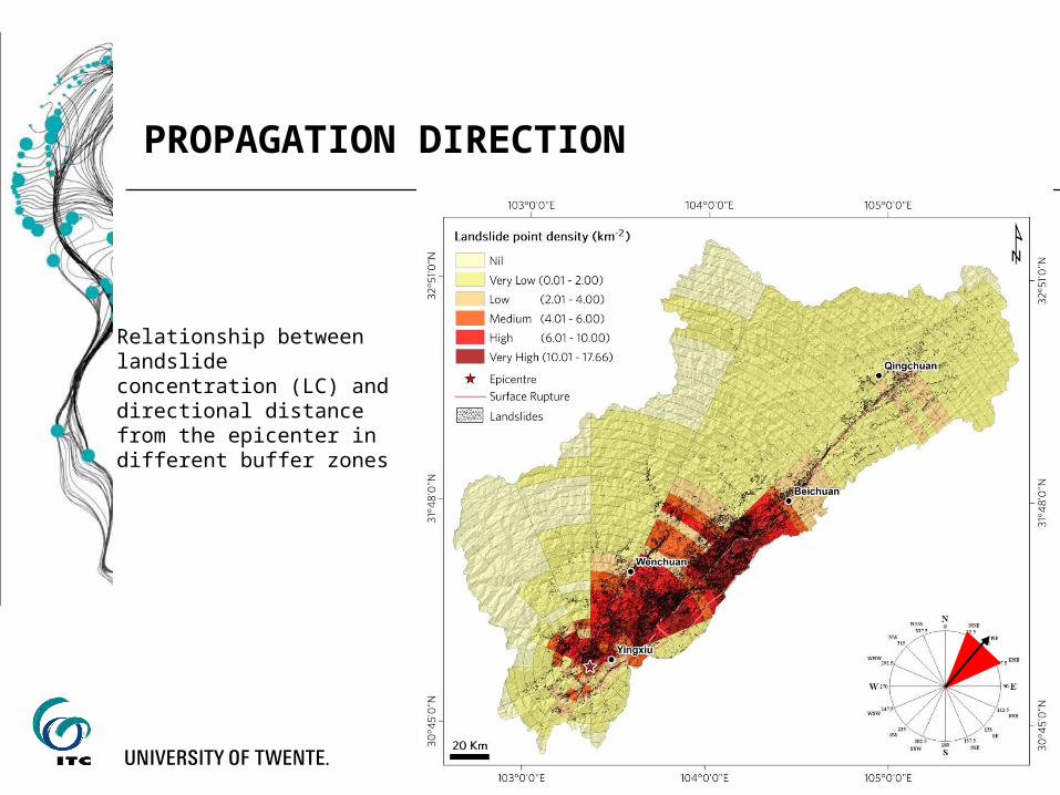
PROPAGATION DIRECTION
Relationship between landslide concentration (LC) and directional distance from the epicenter in different buffer zones
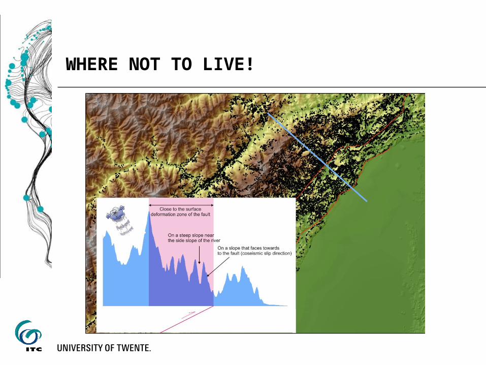
WHERE NOT TO LIVE!
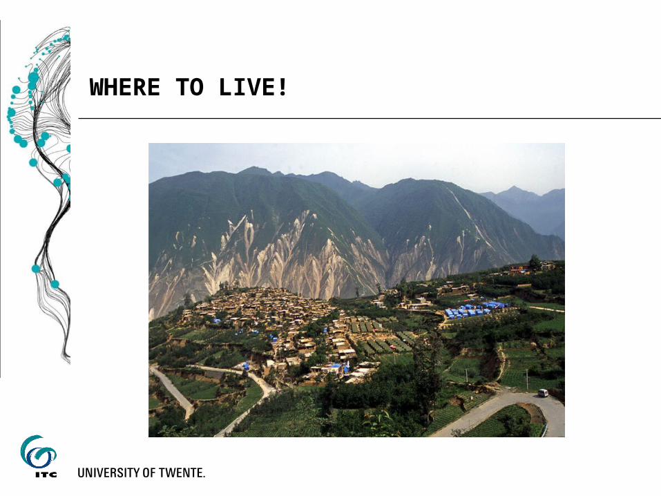
WHERE TO LIVE!

Thanks… 謝謝