SPAIN FRANCE - treaties.un.org
43
No. 907 SPAIN and FRANCE Treaty on boundaries between Spain and France from the valley of Andorra to the Mediterranean (with addi tional act). Signed at Bayonne on 26 May 1866 Final Act approving annexes and regulations relating to the above-mentioned Treaty. Signed at Bayonne on 11 July 1868 Authentic texts: Spanish and French. Filed and recorded at the request of Spain on 21 September 1982. ESPAGNE et FRANCE Traité de délimitation de la frontière entre l'Espagne et la France depuis le val d'Andorre jusqu'à la Médi terranée (avec acte additionnel). Signé à Bayonne le 26 mai 1866 Acte final approuvant les annexes et les règlements relatifs au Traité susmentionné. Signé à Bayonne le 11 juillet 1868 Textes authentiques : espagnol et français. Classés et inscrits au répertoire à la demande de l'Espagne le 21 septem bre 1982. Vol. 1288, 11-907
Transcript of SPAIN FRANCE - treaties.un.org

No. 907
SPAINand
FRANCE
Treaty on boundaries between Spain and France from the valley of Andorra to the Mediterranean (with addi tional act). Signed at Bayonne on 26 May 1866
Final Act approving annexes and regulations relating to the above-mentioned Treaty. Signed at Bayonne on 11 July 1868
Authentic texts: Spanish and French.Filed and recorded at the request of Spain on 21 September 1982.
ESPAGNEet
FRANCE
Traité de délimitation de la frontière entre l'Espagne et la France depuis le val d'Andorre jusqu'à la Médi terranée (avec acte additionnel). Signé à Bayonne le 26 mai 1866
Acte final approuvant les annexes et les règlements relatifs au Traité susmentionné. Signé à Bayonne le 11 juillet1868
Textes authentiques : espagnol et français.Classés et inscrits au répertoire à la demande de l'Espagne le 21 septem
bre 1982.
Vol. 1288, 11-907
1982 United Nations — Treaty Series • Nations Unies — Recueil des Traités 389
[TRANSLATION TRADUCTION]
TREATY 1 ON BOUNDARIES BETWEEN SPAIN AND FRANCE FROM THE VALLEY OF ANDORRA TO THE MEDITER RANEAN
Her Majesty the Queen of the Spains and His Majesty the Emperor of the French, desiring to fix definitively the common frontier of their States and the rights, usages and privileges of the border populations of the two nations between the province of Gerona and the department of the Pyr n es-Orientales from the Valley of Andorra to the Mediterranean, in order to complete from sea to sea the work so successfully commenced and continued in the Treaties of Bayonne of 2 December 18562 and 14 April 1862' and at the same time perpetually to consolidate order and good relations between Spanish and French in that eastern part of the Pyrenees in the same manner as over the rest of the frontier, from the mouth of the Vidasoa to the valley of Andorra, have deemed it necessary to .record in a third and last special Treaty, constituting a continuation of the two mentioned above, the stipulations viewed by them as most suitable for achieving that end, and have for that purpose appointed as their plenipotentiaries:Her Majesty, the Queen of the Spains: Don Francisco Maria Marin, Marquis
de la Frontera, Knight Grand Cross of the Royal Orders of Charles III and Isabella the Catholic, Knight of the Military Order of Saint John of Jerusalem, Grand Officer of the Imperial Order of the L gion d'Honneur, Senator of the Kingdom, Minister Plenipotentiary, Major-Domo for the week of Her Majesty, etc., etc., and Don Manuel de Monteverde y Bethancourt, Field Marshall of the National Armies, Knight Grand Cross of the Royal Orders of Charles III, of Saint Hermenegild and of Isabella the Catholic, twice Knight of the Military Order of Saint Ferdinand, Knight Commander of the Imperial Order of the L gion d'Honneur, Lord of the Bed-chamber of Her Majesty in office, and regular member of the Royal Academy of Sciences of Madrid, etc., etc.;
And His Majesty the Emperor of the French: Mr. Camille-Antoine Callier, Divi sion General, Knight Commander of the Imperial Order of the L gion d'Hon neur, Knight Grand Cross of the Royal Order of Isabella the Catholic, Knight, Second Class, with star, of the Red Eagle of Prussia, etc., etc., and Mr. Georges, Count Serurier, Minister Plenipotentiary, Officer of the Imperial Order of the L gion d'Honneur, extraordinary regular Knight Commander of the Royal Order of Charles III, of the Order of Saints Maurice and Lazarus, of the Order of Christ of Portugal, etc., etc.
who, having communicated to each other their full powers, found in good and due form; having sought out, explained and discussed all the titles that have survived the deleterious action of time, from the age-old origin of the disputes
1 Came into force on 7 March 1869, i.e., 15 day;, after the prbm lgatTon"(ef c 3 on 20 February 1869) of the Final Act of Delimitation dated 11 July T858, In accordance with article XXXII.
2 United Nations, Treaty Series, vol. 1142, p. 317.1 British and Foreign State Papers, 1861-1862. vol. LU, p. 156 (French text); Hertslet. The Map of Europe hy
Treaty, vol. II, p. 1510 (excerpts only).
Vol. 1288,11-907

390 United Nations — Treaty Series • Nations Unies — Recueil des Traités 1982
to be resolved; after hearing the allegations of the interested parties, exploring the places concerned and devoting themselves to establishing and conciliating, with all possible equity, the pretensions and rights asserted on both sides; and taking as a basis the corrected article forty-two of the Treaty of the Pyrenees and the Convention signed in consequence thereof at Llivia in 1660, 1 have agreed as follows:
Article I. The line of common boundaries of the Kingdom of Spain and the French Empire between the province of Gerona and the department of the Pyr n es-Orientales, starting from the peak of Valira, bordering on the district of Maranges and the valleys of Carol and Andorra, shall follow the Pyrenean spur which encloses on the south the valley of Carol, passing through the points Puig Pedr s, Fuente de Boved , Padr de la Tosa, Puig Farin s, Colon rock, peak of La Tosa and rock of El Talayador.
Article H. From the rock of El Talayador the line shall descend along the ravine of Los Mollars or Los Mollasos until it reaches the Mitjana highway, the alignment of which it shall follow until it enters the ravine known as Canal de la Graille; it shall descend along this channel until it meets the stream of San Pedro, and then along the stream of San Pedro to the point where the cadastral limit of La Tour-de-Carol leaves it, and, following that limit, the international line shall proceed along its sinuosities as far as the Iron Cross, a boundary marker common to Guils, Saneja and La Tour.
Article HI. From the Iron Cross, the boundary shall continue to the river Arav or of Carol via the different points that determine the existing uncontested limits between Saneja on the one hand and La Tour and Enveitg on the other.
Article IV. After passing the river Arav , the demarcation shall proceed along the line which Puigcerd and Enveitg recognize as their common boundary from the said river to the diversion channel that conducts the waters to Puigcerd .
Article V. The frontier shall cross the channel and, via the line that now separates the territories of Puigcerd and Ur, shall proceed to the Llivia bridge over the Reur River, at which point the districts of Puigcerd , Ur and Bourg- Madame abut, the last-mentioned being the commune referred to by the name Hix in the Llivia Convention.
Article VI. From the Llivia bridge the limit-line shall descend the course of the Reur, which divides Puigcerd from Bourg-Madame, to its confluence with the Segre in accordance with what is determined by the International Commis sion of Engineers, as prescribed by article XIII of the additional instrument of today's date relating to the entire frontier.
Article VII. After passing the Segre, the international line between Bourg- Madame and Aja shall follow the limit adopted by both towns as far as the territory of Palau.
Article VIII. From there, instead of the highly irregular course of the first portion of the frontier between Palau and Aja, the new demarcation agreed upon between the interested parties shall be adopted, consisting of two straight lines which meet near the bank or margin of Las Colominas, whereafter the demarcation shall continue along the second part of the present frontier line to the river Lavanera, where Aja and Palau cease to abut.
1 See note 1, p. 393.
Vol. 1288, II-907

1982_____United Nations — Treaty Series • Nations Unies — Recueil des Traités______391
Article IX. The boundary shall cross the river Lavanera and go on to the mouth of the stream which the Spanish call no Envolante or barranco de Palau and the French, Vilallovent brook; it shall ascend this Vilallovent and Palau brook as far as a bifurcation and proceed to the Coll de Marc .
Article X. From there the boundary line shall go to take the road from Puigcerd to Barcelona and continue along it without leaving it until the Cruz de Mayans, entering between the Solana del Plan de Balados of the district of Palau and the Solana de Saltegal belonging to Puigcerd .
Article XL From the Cruz de Mayans the border shall proceed along the crest which runs into the height known as Bagarret de Mayans or Cima de Coma Morera, dividing the district of Tosas from that of Palau.
Article XII. From the said height the line shall continue along the summit between the Spanish valley of Rivas and French Cerdana, passing through the Pl de Salinas and Puig Mal and on to the peak of Eina, at which this crest unites with the principal chain of the Pyrenees.
Article XIII. From the peak of Eina the boundary shall run along the top of the principal ridge as far as the Coll de Panis s, with only two exceptions; the first, between the pass of Las Manzanas and La Damproy, where it shall descend slightly on the southern slope, passing round the territory of the French commune of Coustouges, which touches the rivers Muga and Mayor; and the second, from the Ras de Mux to the Castillo de Cabrera, running slightly down the northern slope in order to leave the sanctuary of Salinas in Spain.
Article XIV. From the Coll de Panis s the boundary shall proceed to the ruined hermitage of Our Lady of the same name, where the military zone of the French fort of Bellegarde begins, and shall follow the demarcation thereof, complying, as shall be set out in the Record of Demarcation, with the prescrip- 1 tions of the Treaty of 12 November 1764' and with the existing landmarks, up to ' a place in the Sierra de Puig Mal which the Spanish call Las Fontetas, situated on the crest of the Pyrenees.
Article XV. From there the international line shall continue along the same crest, called by the French Les Alb res, and, passing through the Torre de Caproig, shall end at the Cova Foradada, situated on the shore of the Mediter ranean, adjacent to the cape of Cerb re, which shall remain in France.
Article XVI. The perimeter of the jurisdictional district of the Spanish town of Llivia, enclaved in France, starting from the Pontarr de Xidosa, situated on the road from Puigcerd to Llivia, and heading southward, shall proceed succes sively through the Moj n (landmark) den Punet, Paso dels Bous en Campo Ras, sierra of Concellabre, sierra of Santa Leocadia and that of Picasola and, after a few sinuosities contiguous to the districts of Err and Ro, shall reach the Fuente del Estany, follow the road from Ro to Llivia and go to El Tosal del Tarrasol, which is a hill on the left bank of the Segre. After passing that river, the demarca tion shall ascend along the banks of Astange and Palmanill to a cross carved in stone and shall continue through the landmark of the Ribera des Vails, the Tosa de Ventol , Prat del Rey, ravine of Tudor and the Carrerada de Tudor to Angoustrine, then on until it stops at a point in the Sierra de Angoustrine which shall be designated in the Record of Demarcation. From this place it shall proceed
1 British ami Foreign StutL' Papers, 1865-1866, vol. LVI, p. 224 (English text).
Vol. 1288, 11-907

392 United Nations — Treaty Series • Nations Unies — Recueil des Traités 1982
through the Cross of the Oratory, Las Esquerras, La Coma and El Tud de Flori and El Tosal de Piedra Larga, closing the circuit at El Pontarr de Xidosa. Jn this demarcation the existing limits shall serve as a guide in so far as they are not opposed to what is specified here.
Article XVII. To obviate any doubts and disputes, both between private persons and between the public services of the two countries, concerning the international boundary summarily indicated in the preceding articles, the said boundary shall be demarcated as soon as possible with durable, suitably placed landmarks.
This operation shall be carried out by Spanish and French officials, in the presence of delegates of the municipalities concerned qualified to provide local indications, but having no other mission than to apprise themselves of the demarcation made between their respective territories and give testimony con cerning it.
There shall be drawn up a General Record of Demarcation, all of whose provisions shall have the same force and validity as if they were an essential part of the present Treaty.
Article XVIII. The inhabitants of Guils, with their livestock and their belongings, shall have free passage however and whenever they wish between Puig Farin s, Roca Colon and Pico de la Tosa, in order to communicate with the lands which the said town has adjacent to the Boved spring.
Article XIX. The livestock of Guils and that of La Tour-de-Carol shall jointly enjoy all the natural pastures now existing in the land circumscribed by a line which, starting from the point where the international frontier leaves the stream of San Pedro, a short distance above the hamlet of that name, follows the frontier to the stream of Llin s, ascends it to the Coll de la Somera, there proceeding along the Mitjana highway to the river Tartar s, whose bed it follows against the stream until it reaches the crest of a slight undulation that leads to El Talayador; from there it goes to Eagle Rock and along the southern edge of the forest of La Tour until it meets the Mitjana highway, along which it returns to the point at which this ancient way crosses the river Tartar s; thereafter it descends that river and the stream of San Pedro, which branches off from it, to the starting point. Be it understood that on all this common pasture-land, neither French nor Spanish shall hereafter have the right to break up the ground, plant, build or undertake anything that would change the nature and intended use of the soil.
To legitimate this present state of things, which differs from the former state, and to nullify any pretension to the contrary, the French Government shall pay to Guils, within the first year of operation of this Treaty, a remuneration in cash equal to half the value of all the natural pastures comprised in the space enclosed by the line just described from the starting point in the stream of San Pedro to El Talayador, passing through the Coll de la Somera, and the one running from El Talayador to the Pico de la Tosa, proceeding along the crest to Eagle Rock and continuing along the same ridge, which the Spanish call Sierra de la Baga and the French, Lo Cim del Bosch, to Castillo rock or peak, and then along the top of the sierra of La Tour to the point closest to the starting point in the stream of San Pedro, where the new line closes the perimeter. Notwithstanding, two portions in which the former usages have not changed must be excluded from this land, namely: one comprised between the Mitjana highway and the
Vol. 1288, 11-907

1982_____United Nations — Treaty Series • Nations Unies — Recueil des Traités______393
streams of the rivers Tort and Tartar s, and the other between the ravine of Los Mollars, El Talayador, Eagle Rock, the southern edge of the forest of La Tour and the Mitjana highway.
The appraisement of this indemnification shall be made by experts appointed by the two Governments.
Article XX. The canal which conducts the waters of the Arav to Puigcerd , situated almost entirely in France, shall continue to belong, with its banks as modified in consequence of the passage of the imperial highway leading to Spain, and as private property, to the town of Puigcerd , as it was before the division of Cerdana between the two Crowns.
Relations between the owner and persons having irrigation rights shall be regulated by the International Commission of Engineers to be appointed for control of waters, as provided by the Additional Instrument concerning the general provisions applicable to the entire frontier, dated the same day as the present Treaty.
Article XXL In accordance with the Convention of 12 November 1660, l the free use of the roads which cross the enclaved district of Llivia and that of Puigcerd shall continue to be characterized by complete franchise for French nationals going from one point to another in French Cerdana, both for agricultural purposes and for commercial operations and other life uses. The same freedom and franchise shall also be maintained for Spanish nationals who cross the French territory between Llivia and Puigcerd by the direct road that unites those two towns, crossing the Reur River by the Llivia bridge, which belongs half to Spain and half to France.
On both sides the Customs service shall be set up in such a way as not to interfere with the enjoyment of these exemptions.
This freedom of circulation shall not otherwise alter territorial sovereignty over such roads; thus, foreigners who commit crimes, offences or contraventions on any of the said ways shall be subject to the tribunals and authorities of the country in which the road is situated.
Article XXII. The obligation imposed on Spain by that same Convention not to fortify militarily, at any time, Llivia or any other point in the territory enclaved in France is hereby maintained.
Article XXIII. In virtue of the Compromise of 1754, the livestock of Llivia shall have free passage through the territory of Angoustrine for the purpose of going to the pastures of Carlit and returning from them.
To reach the La Creuheta or Costa de Nambet road, which leads to the said pastures, the livestock shall pass in even-numbered years, starting from the Carrerada adjacent to El Tudor de Sareja, through the places called Tudor, Nivol and Eucenirma, along the outer edge of the Cuesta de Angoustrine, and in odd- numbered years it shall pass along the other side of Tudor, climbing successively up through the places called El Home Mort and La Coma de Margall and turning to the left toward the Sierra de Angoustrine, below the place known as La Cadira del Capell , in order to take the La Creuheta road.
firilfsft (im/fWl't;/! State ?'«pprJn^5'l'S(56,""vol'.'C7r,"pr^2r(French text).
Vol. 1288,11-907

394 United Nations — Treaty Series • Nations Unies — Recueil des Traités 1982
In order that the livestock of Llivia may have free passage through the said places, the inhabitants of Angoustrine shall be obliged to leave them fallow alternately one year out of every two, according to the passage of the flocks or herds.
However, inasmuch as this easement whereby the fields must be left fallow or exposed to trampling by the livestock is onerous to Angoustrine and not indis pensable for satisfying the needs of Llivia, it shall be abolished as soon as Angoustrine offers to Llivia a permanent way which, in the opinion of the respective experts, can replace the present passages without any inconvenience.
Once the permanent way is accepted by the experts and put into use, animals of Llivia which, during the first five years, leave the way and enter the cultivated fields of Angoustrine may be driven out from them without the penalty of seizure or that of a fine being incurred, unless the herdsmen intentionally force them to do so, in which case they shall be subject to the penalty for their infraction. Once the five-year period has elapsed, livestock of Llivia shall be subject to the general regulations on seizures to which article XXX of this Treaty relates.
So long as such permanent way has not been opened, at least eight days before the livestock is to leave for Carlit, the Alcalde of Llivia shall notify the Maire of Angoustrine of the precise time of passage, in order that any precau tionary measures deemed useful may be taken in due time; but once the appointed day comes, the livestock of Llivia may not in any way be prevented from crossing the designated lands through which it is to go to Carlit, whatever the state of cultivation of those lands that have not remained fallow may be.
Article XXIV. The inhabitants of Llivia shall have right of passage on the road from La Mola that goes to the pond of La Pradella in order to remove from their property in El Bach de Bolquera such wood as can be brought by pack animal; however, as that way does not lend itself to the transport of wood of greater size, Llivia shall maintain for that purpose the right to use the road called the Coll Pau road, which passes through Estavar and Egat and through the State forest known as La Calma, ending at El Bach de Bolquera.
If for any reason the French Administration should need to intercept this road, it shall come to an agreement with the Spanish Administration for providing Llivia with a suitable passage.
Article XXV. Llivia is authorized to mend and improve, at its own expense, bad roads of La Creuheta and La Mola, provided that no injury to others ensues.
Article XXVI. The common right of pasture now existing between Angoustrine and Llivia on the communal pastures of the land circumscribed by the limit dividing the two jurisdictions and by a line which starts from El Prat del Rey, passes through La Cadira del Capell and Los Escubills and follows the crest of the sierra of Angoustrine until it meets the territory of Llivia is maintained.
Article XX VII. The right to irrigate with the waters of the canal of Angou strine shall belong both to the inhabitants of the town of Angoustrine and to those of Llivia, the French using them each week from Sunday at sunrise until Wednes day at sunset, and the Spanish, from that point until sunrise on the following Sunday. The establishment of the rules for the control of such watering and for the policing of the canal shall be entrusted to the International Commission of Engineers to be appointed to regulate the use of waters on the frontier.
Vol. 1288, 11-907

1982 United Nations — Treaty Series • Nations Unies — Recueil des Traités______395
Article XXVIII. The singular situation of Llivia, enclaved in France, and more particularly the sinuosities and extreme ruggedness of the Pyrenees oblige frontier-dwellers, both Spanish and French, to take some stretches of road that cross through foreign territory in order to travel from one point to another in their own country, wherefore they shall both continue to enjoy the necessary franchise for their free circulation along those passages, on the express condi tion, however, that they must not leave the road, which shall be absolutely prohibited for the service of foreign agents of the public force. These passages are:1. The road followed by Spanish and French persons going on a pilgrimage to
the sanctuary of Our Lady of Nuria in Spain, passing through Err and the Coll de Fenestrella.
2. For Spanish and French nationals, the path which, from Puig or Roca Colon a point common to the three municipal districts of Set Casas, Mantet and Prats de Moll , goes to the Pla de la Muga following the sinuosities of the crest, and passes alternately from one country to the other.
3. For the Spanish, the stretch going from the Muga de Dal to Coustouges and descending to the river Mayor.
4. For the French, in particular the inhabitants of Saint-Laurent de Cerdans and of Coustouges, transit through the projection of Spanish territory into France between the Coll de Falcon and Puig de Mux .
5. The road which the Spanish follow in France from the hermitage of Salinas to the Coll de Ll or Dalli, skirting the Sarrat del Faig on the north.
6. The passage frequented by the French in Spain between the Coll de Priorat and the Coll de Panis s.
7. The stretch of main highway from La Junquera to Perpignan, from the border bridge to the junction in France of the road which heads east along the slope of the Sierra de Pert s, going alternately from one State into the other.
8. The road just mentioned, from the highway to the Coll de For at, through which it proceeds to the hermitage of Recasens in Spain.Article XXIX. Written or verbal agreements existing at present between the
frontier inhabitants of the two countries and not contrary to the present convention shall maintain their force and validity until the expiration of the term for which they were concluded.
With the exception of what is stipulated in such agreements and in the present Treaty, no right or usage whatsoever may on any grounds be claimed from the neighbouring nation, even if not contrary to those agreements or to this Treaty.
Frontier-dwellers shall nevertheless maintain the faculty which they have always had to enter among themselves into such pasturage or other agreements as they may deem favourable to their interests and good neighbourly relations; hereafter, however, approval must be obtained from the civil governor and the prefect in order for such agreements, whose duration shall not exceed five years, to be valid.
Article XXX. The regulation relating to seizures of livestock, annexed to the Treaties of Bayonne of 2 December 1856 and 14 April 1862, shall apply to the
Vol. 1288, 11-907

396______United Nations — Treaty Series • Nations Unies — Recueil des Traites_____1982
entire frontier delimited in the foregoing articles I to XVI inclusive and shall consequently also figure as an annex following the General Record of Demarca tion called for in article XVII above.
Article XXXI. Donations, declarations, conventions, arbitral awards and agreements of any nature referring either to the tracing of the frontier from the Valley of Andorra to the Mediterranean and that of the enclaved territory of Llivia or to the legal situation, rights and servitudes of the limitrophe territories are rendered null de facto and de jure in so far as they are contrary to the stipula tions contained in the preceding articles.
Article XXXII. The present Treaty shall take effect 15 days after the promulgation of the General Record of Demarcation provided for in article XVII.
Article XXXIII and final. This Treaty shall be subject to ratification, and the ratifications shall be exchanged at Paris as soon as possible.
IN WITNESS WHEREOF the respective Plenipotentiaries have signed it and affixed thereto the seal of their arms.
DONE at Bayonne, in duplicate, on 26 May of the year of grace 1866.
The Marquis DE LA FRONTERA General CALLIER MANUEL MONTEVERDE Comte S RURIER
ADDITIONAL INSTRUMENT TO THE THREE TREATIES ON BOUNDARIES OF 2 DECEMBER 1856,' 14 APRIL 18622 AND 26 MAY 18663 BETWEEN SPAIN AND FRANCE
The undersigned, Plenipotentiaries of Spain and France for international delimita tion in the Pyrenees, duly authorized by their respective sovereigns, in order to unite in a single instrument the provisions applicable in both States to the entire frontier and relating to the preservation of the demarcation, to livestock and pastures, to properties intersected by the frontier and to the enjoyment of waters for common use, which provi sions, in view of their generality, require a special place which they could not be accorded in the Treaties of Bayonne of 2 December 1856' and 14 April 1862 2 or in the Treaty dated today,' have agreed as follows:
PRESERVATION OF THE INTERNATIONAL DEMARCATIONArticle I. Every year in the month of August the higher administrative authorities
of the limitrophe provinces and departments shall come to an agreement for ordering the municipal councils concerned to appoint delegates who, in each municipal district and in concert with those of the contiguous territory of the other State, shall make, without delay, a thorough inspection of the demarcation of their frontier and, on each side, draft a record to be delivered officially to the said higher authorities for such action as is proper.
Article II. Without prejudice to the provisions of the foregoing article and with a view to ensuring the preservation of the boundary-marks over the entire international
1 United Nations, Treaty Series, vol. 1142, p. 317.2 British and Foreign State Papers, 1861-1862, vol. LII, p. 156 (French text): Hertslet, The Map nf Europe
by Treaty, vol. II, p. 1510 (excerpts only).3 See p. 389 of this volume.
Vol. 1288,11-907

1982 United Nations — Treaty Series • Nations Unies — Recueil des Traités 397
line in a manner more efficacious than that hitherto established, the civil governors and the prefects shall come to an understanding, each in respect of his own province or department, with the chiefs of the different branches of the public administration, in order for them to order their subordinates employed on the frontier to see to it, in close concert with the municipal agents, who shall be those most specially and directly charged with this supervision, that no damage is caused to the said boundary-marks, to report any damage that has occurred, to try to discover its perpetrators and, lastly, to communicate to the competent authorities all matters related to this subject.
Article III. The civil governors and prefects shall act jointly to re-establish boundary- marks that have been destroyed or extracted, all expenses thus incurred being paid equally by the two Governments, except the fees of engineers, which shall be paid individually by the respective States, unless it is agreed that a single engineer shall be appointed, in which case his fees shall be defrayed by the two countries. If the perpetrators of the damage are discovered, they shall be personally liable for it.
FLOCKS, HERDS AND PASTURES
Article IV. With a view to the reciprocal promotion of the pastoral industry on both sides of the frontier, livestock of all species which goes directly from one country to pasture-lands in the other in which it may legitimately graze shall not be subject to any duty or any fiscal or other formality, and the same exemption shall apply to livestock which must use a road or cross a territory of the neighbouring State in order to reach pastures, either in that State or in its own, in which it may legitimately graze.
Article V. Flocks or herds which, while lawfully in foreign pastures on the frontier or while going to or returning from such pastures, stray, for some fortuitous reason, less than 500 metres from those pastures or from the road which they are required to follow, shall not be considered contraband or be subject, in consequence, to any of the penalties imposed on contraband by the public treasury, providing no fraudulent intent is evident; if, however, as a result of such accidental straying, they cause any damage, the liability therefor shall fall on the owners of the livestock.
Article VI. The municipalities of the frontier villages which legitimately have exclusive enjoyment of pastures in the neighbouring State shall have the right to appoint, by themselves, guards to watch over their rights.
Where enjoyment is common to the frontier inhabitants of the two countries, each of the municipalities concerned may have its own guards or choose them in agreement with the other users.
The guards, provided with the document which accredits them, shall take an oath before the competent authority of the country in which such enjoyment is exercised and present their reports to that authority.
PROPERTIES DIVIDED BY THE FRONTIER LINEArticle VII. Notwithstanding the fact that the international limit cuts through various
properties, some of which belong to Spanish and others to French nationals, and that each portion of such properties maintains the nationality of the country in which it is situated, the owners shall none the less enjoy complete freedom to cultivate the portion of land lying in the neighbouring State, having the right to cross the frontier freely, both going and returning, with everything pertaining to such cultivation and with all the products harvested. However, the proprietors shall have the option of not using the benefit of free introduction into their country of such products, which shall then be subject to the civil law of the territory in which they are harvested.
If the proprietor is established on the part of his property situated in the other State, he shall have the right to gather and keep there, free and exempt, the products of the entire estate and to introduce them subsequently into his own country without being subject to any import or export duty.
Vol. 1288, H-907

398 United Nations — Treaty Series • Nations Unies — Recueil des Traités 1982
REGIMEN AND ENJOYMENT OF WATERS FOR COMMON USE BETWEEN THE TWO STATES
Article.' VI11. Standing and running waters, whether publicly or privately owned, are subject to the sovereignty of the State in which they are situated and shall consequently be governed by the legislation of that State, subject to any amendments agreed on between the two States.
Watercourses change jurisdiction when they pass from one nation into the other, and, in the case of rivers which serve as a frontier, each State shall exercise its jurisdiction up to mid-stream.
Article IX. In respect of watercourses which pass from one State to the other or which serve as the frontier between the two, each Government, without prejudice to its right to make, where necessary, an examination with both sides represented, recognizes the legality of the irrigation, installations and water rights for domestic use existing at present in the other country, by virtue of a concession or title or by prescription, it being understood that in each such case no more water must be used than is necessary for obtaining the useful effect sought, that abuses must be abolished and that such recognition in no way diminishes the rights of the respective Governments to authorize works of public utility, subject to payment of the legitimate indemnification.
Article X. If, after the usage rights considered legitimate by both sides, respectively, have been satisfied, there remains, based on a previous summer gauging, available water in streams on passing the frontier, the surplus shall be divided immediately between the two countries, in proportion to the amount of irrigable land belonging to the respective immediate riparians, not counting land that is already under irrigation.
Article XI. If one of the two States proposes to carry out works or new concessions that might alter the rate of flow or volume of a waterway whose waters are utilized further down or on the opposite side by riverains of the other country, notice shall be given in advance to the higher administrative authority of the province or department to which such riverains belong by the corresponding authority in whose jurisdiction the execution of the project is contemplated, in order that, if it is detrimental to the rights of the riverains of the neighbouring sovereignty, it will be possible to protest in due time to the proper quarter and safeguard the interests that might be compromised on both sides. If the works or concessions are to take place in a municipal district contiguous to the frontier, then, along with the persons in charge in one State, the engineers of the other State shall also have the right to take part in the local inspection, being notified for that purpose duly in advance.
Article XII. Lower lands shall be required, with respect to higher lands, to receive the waters which come from the latter together with the material that they carry naturally without any intervention of the hand of man; on them no dams or other obstacles shall be constructed which are injurious to the riverains further up, who are likewise prohibited from doing anything which might aggravate this servitude that weighs upon those situated below.
Article XIII. On rivers which serve as a frontier, any riparian may, subject to the authorization necessary according to the laws applicable to him, create plantations and carry out works of repair and protection on his bank, provided that they do not alter the volume and course of the stream in a manner prejudicial to the neighbours and do not encroach on the bed, defined as all the land watered by the stream during its ordinary freshets.
In respect of the Reur River, which serves as frontier between the territories of Puigcerd and Bourg-Madame and which, owing to its peculiar circumstances, has no clearly defined natural margins, the zone in which planting and construction are prohibited shall be demarcated on the basis of what was agreed between the two Governments in 1750 and renewed in 1820, though this may be modified, if it is possible to do so, without
Vol. 1288, 11-907

1982 United Nations — Treaty Series • Nations Unies — Recueil des Traités______399
detriment to the regimen of the river or the adjacent lands, in order that, when this additional instrument takes effect, riparians undergo the least injury possible when it becomes necessary to leave the newly defined bed free of any obstruction.
Article XIV. If, owing to collapse of the banks or to objects carried by the water, deposits or other natural causes, there might result any alteration or obstruction of the watercourse injurious to the riverains of the other country, such riverains shall have right of recourse to the competent jurisdiction in order to have the repair or removal of material done by the appropriate quarter.
Article XV. Whenever, aside from legal disputes, which fall within the exclusive competence of the ordinary courts, disagreements arise between riverains of different nationalities or complaints must be brought forward concerning water use, the persons concerned shall apply to their respective authorities in order for them to resolve the matter by agreement with the authorities of the neighbouring country, if it is within their jurisdic tion; in case of incompetence or disagreement or in case the persons concerned do not accept the decision handed down, recourse may be had to the higher administrative authority of the province or department.
Article XVI. The higher administrations of the border provinces or departments shall work in concert, in the exercise of their functions, for the settlement of questions of general interest and of interpretation or amendment of their regulations relating to water whenever interests on both sides are involved, and, should they fail to reach agreement, the difference shall be submitted to the two Governments.
Article XVH. The civil governors and prefects on both sides of the frontier may, if they deem it appropriate, establish by mutual consent, with the approval of the Govern ments, elective syndicates composed of equal numbers of Spanish and French riverains to supervise the execution of the regulations and report any violators to the appropriate quarter.
Article XVIII. An International Commission of Engineers shall survey the appro priate places on the border between the province of Gerona and the department of the Pyr n es-Orientales and other points on the frontier with a view to examining, in the adjacent municipal districts of the two monarchies, or elsewhere as needed, the use made of waters at present for irrigation, installations and domestic purposes, in order to allot in each case only that quantity of water which is necessary and to eliminate abuses. The Commission shall determine for each watercourse, on the basis of the summer gauging made at the point where it crosses the frontier, the volume of water still available and the extent of the irrigable lands not yet under irrigation which belong to immediate riparians of both countries; it shall also undertake the operations concerning the Reur specified in article XIII; it shall propose the measures and precautions likely to ensure the execution, on both parts, of the regulations and to prevent, in so far as possible, any dispute among riverains; and lastly, it shall examine the scope of the powers which should be given to the mixed syndicates, should they be established.
Article XIX. Immediately after this instrument is ratified, the Commission of Engineers referred to in article XVIII may be appointed, in order to proceed immediately to its work, starting with the rivers Reur and La Vanera, where the urgency is the greatest.
Article XX. The preceding provisions shall apply to the entire frontier from sea to sea and to the enclaved territory of Llivia and shall have the same force and validity as if they were inserted textually in the two Treaties of Bayonne of 2 December 1856 and 14 April 1862 and in the third, bearing today's date, which completes them, all different or contrary stipulations of the first two aforementioned Treaties being abrogated.
RECTIFICATION OF ARTICLE xv OF THE BORDER TREATY OF 1862Article XXI. Whereas the third paragraph of article XV of the Border Treaty of
14 April 1862 is not in accord with the usage then existing, which the Joint Commission meant to maintain without any change, the said paragraph is declared null and void and is
Vol. 1288, 11-907

400 United Nations — Treaty Scries • Nations Unies — Recueil des Traités 1982
rectified as follows and shall have, in this new wording, the same force and validity as if it were an integral part of the said Treaty: 1
"The livestock of Broto and Bareges may enjoy in common the seven portions of the mountain of Usona until 11 June of each year; starting from that date, however, only tenants and subtenants shall have the right to pasture their animals in the portions reserved for them."Article XXII. The present instrument shall be subject to ratification and the ratifica
tions shall be exchanged at Paris as soon as possible.IN WITNESS WHEREOF the respective Plenipotentiaries have signed it and affixed
thereto the seal of their arms.DONE at Bayonne, in duplicate, on 26 May (of the year of grace) 1866.
The Marquis DE LA FRONTERA General CALLIER MANUEL MONTEVERDE Comte SERURIER
1 Which read as follows: "The livestock of Broto and Bareges may enjoy in common the seven portions of the mountain of Usona until 11 June of each year; starting from that date, however, the pasturies shall be pro hibited to livestock of all kind until 22 July, after which period only tenants and subtenants shall have the right to pasture their animals in the portions reserved for them".
Vol. 1288, 11-907

1982_____United Nations — Treaty Series • Nations Unies — Recueil des Traités______401
[TRANSLATION TRADUCTION]
ANNEXES 0F 11 JULY 1868 (FINAL ACT 1 OF THE ARRANGEMENT ON BOUNDARIES)2
Her Majesty the Queen of the Spains and His Majesty the Emperor of the French, desiring to regulate definitively the execution of the Treaty on Boundaries concluded at Bayonne on 26 May 1866; 2 modify certain provisions of that covenant in order to bring them into greater harmony with the aspirations of the persons concerned, as more clearly expressed by them; complete the designa tion of the roads on which passage is free; sanction certain usages, either existing or agreed on by both Parties; and give legal force to the regulations formulated by the International Commission of Engineers mentioned in article XVIII of the Additional Instrument signed at Bayonne on 26 May 1866, 2 have appointed as their plenipotentiaries:Her Majesty, the Queen of the Spains: Don Francisco Maria Mann, Marquis de la
Frontera, Knight Grand Cross of the Royal Orders of Charles III and Isabella the Catholic, Knight of the Military Order of Saint John of Jerusalem, Grand Officer of the Imperial Order of the L gion d'Honneur, Senator of the Kingdom, Minister Plenipotentiary, Major-Domo for the week of Her Majesty, etc., etc., and Don Manuel de Monteverde y Bethancourt, Field Marshall of the National Armies, Knight Grand Cross of the Royal Orders of Charles III, of Saint Hermenegild and of Isabella the Catholic, twice Knight of the Military Order of Saint Ferdinand, Knight Commander of the Imperial Order of the L gion d'Honneur, Lord of the Bed-chamber of Her Majesty in office, and regular member of the Royal Academy of Sciences of Madrid, etc., etc.;
And His Majesty the Emperor of the French: Mr. Camille-Antoine Callier, Division General, Grand Officer of the Imperial Order of the L gion d'Hon neur, Knight Grand Cross of the Royal Order of Isabella the Catholic, Knight, Second Class, with star, of the Red Eagle of Prussia, etc., etc.;
who, having communicated to each other their respective full powers, found in good and due form, have drawn up and united in the first part of this Final Act the following five annexes to the Treaty signed at Bayonne on 26 May 1866 and inserted in the second part the regulations for the control of waters, prepared by the aforementioned Commission of Engineers.
PART ONE
ANNEX I
RECORD OF DEMARCATION OF THE FRONTIER BETWEEN THE PROVINCE OF GERONA AND THE DEPARTMENT OF THE PYR N ES-ORIENTALES
Pursuant to article XVII of the Treaty on Boundaries signed at Bayonne on 26 May 1866, the Plenipotentiaries of Spain and France, assisted by Don Angel Alvarez de Araujo,
1 Came into force on 7 March [869, in accordance with article XXXII of the Treaty.2 See p. 389 of thii volume. ' See p. 396 of this volume.
Vol. 1288. 11-907

402 United Nations — Treaty Series • Nations Unies — Recueil des Traités 1982
Staff Colonel, Knight of the Orders of Santiago and Saint Hermenegild, Knight Commander of the Order of Charles III, and Don Juan Pacheco y Rodrigo, Staff Captain, on the one hand; and on the other, by Mr. Pierre-Gustave, Baron Hulot, Staff Major, Officer of the Imperial Order of the L gion d'Honneur and Knight of the Royal Order of Saints Maurice and Lazarus, and Mr. Pierre-Antoine-Bruno Boudet, Staff Major, Officer of the Imperial Order of the L gion d'Honneur, Knight of the Spanish Royal Order of Charles III and of that of Saints Maurice and Lazarus, undertook, with the attendance of the delegates of the Spanish and French municipalities concerned, the definitive determination and demarcation of the dividing line between the Spanish province of Gerona and the French department of the Pyr n es-Orientales.
SECTION ONE. DEMARCATION OF THE FRONTIER LINE FROM THE VALLEY OF ANDORRATO THE MEDITERRANEAN
The border markers shall consist of landmarks or boundary-stones and crosses, with the exception of the boundary marks encircling the fort of Bellegarde. The stones or pillars shall be prism-shaped, having a height of 80 centimetres and a square base measuring 50 centimetres on each side. Crosses shall measure 20 centimetres, with four equal members engraved in firm rock within a rectangle 40 centimetres high by 35 wide.
Sculpted on all markers there shall be a serial number, written herein at the beginning of the paragraph in which the site and nature of the corresponding marker are designated, beginning with number 427, which immediately follows the last one in the record of demar cation signed on 27 February 1863, as first annex to the Border Treaty of 14 April 1862' comprising the boundary from the eastern extremity of Navarra to the Valley of Andorra.
Number 427. Starting from the Pico den Valira, situated on the crest of the Pyrenees, between France and Andorra, there begins, heading toward the south, a spur on which is situated a pass well known by the name Coll den Gait or Portella Blanca de Andorra. There a landmark bearing number 427 was placed on the northern edge of the road, at a point common to Spain, France and Andorra.
The frontier continues from marker 427 along the summit of the said spur, climbing up to the peak called by the Spanish Toseta de la Esquella, and by the French, Camp- Couloumer. From this summit, which forms a tableland, two secondary ridges run off: one heading toward the south, entering Spain, and the other, toward the east, being known by the Spanish as Sierra de la Esquella, along whose crest the frontier runs, passing through the Coll and Peak of Bresoll, until it reaches the Portella den Courts or de Maranges.
428. Landmark at the said Portella. The international line continues along the same crest to the peak of Puig Pedres, where it leaves the spur and goes directly to the Fuente de Boved .
429. Cross at the meeting point of two-brooklets which form the Fuente de Boved , on a rock, in the inclined surface facing east.
430. At a distance of 1,000 metres from the previous marker, nearly in the direction that was being followed, cross on the highest horizontal surface of the Padr de la Tosa, which is a peak on the crest of the spur that was abandoned at Puig Pedros.
431. Proceeding toward the north-east at an angle of 148 degrees to the previous direction, at a distance of 1,000 metres, a landmark was erected on the top of an eminence known as Puig Farin s.
It is understood that the angles of direction mentioned in this Act are reckoned, at each point, from the direction that was being followed, and the distances, from the preceding boundary-mark, unless otherwise specified.
1 British and Foreign State Papers, 1861-1862, vol. LII, p. 156 (French text).
Vol. 1288, I1-90/

1982 United Nations — Treaty Series • Nations Unies — Recueil des Traités______403
From Puig Farin s th international line continues, forming an angle of 97 degrees, over a slight rise that separates the Pl de la Vila from the Tosas Bajas, as far as the peak which the French call Farinol s Peak, 500 metres from number 431; and from there the frontier goes in a straight line, veering slightly toward the east, to the next boundary- mark.
432. Cross facing north on the top of the Roca Colon, which is a craggy hill at a distance of 800 metres from Farinol s Peak. Bending toward the north-east at an angle of 110 degrees, the frontier runs directly to the peak of La Tosa, situated at the origin of the sierra which the Spanish refer to as de la Baga and the French, de la Tosa.
433. Landmark on the line just indicated, 270 metres from the Roca Colon.434. Landmark at 405 metres on the peak of La Tosa. Starting from here, the
international line changes direction toward the south-east, running along the crest of the Sierra de la Baga or de la Tosa.
435. Cross on the nearly horizontal surface of a large stone, to the east of a crag situated in a slight dip in the crest, 360 metres from the peak of La Tosa.
436. At a distance of 300 metres, vertical cross facing east on the Talayador rock.437. At a distance of 410 metres in a straight line, cross on an inclined surface facing
south-east. The boundary leaves the crest and heads in a more southerly direction to the next marker.
437. I. Vertical cross at a distance of 112 metres on the slope of the sierra above the eastern face of a large, white rock that is easy to distinguish. The south-easterly direction is taken once again, and the line proceeds directly to the confluence of two rivulets that form the stream of Los Mollars or Los Mollasos.
438. Cross at a distance of 380 metres on the south-eastern face of a large rock in the shape of a triangular pyramid, 70 metres before one reaches the aforementioned confluence. The course of the stream of Los Mollars is followed until it enters the river Tartar s, then the course of the Tartar s, until it meets the stream of Mayans.
439. Landmark at the junction of the Tartar s stream with that of Mayans, at a distance of 520 metres, at which junction the Mitjana highway crosses the river Tartar s.
439. I. The demarcation makes an angle of 130 degrees in order to follow the align ment, here confused, of the Mitjana highway, and at a distance of 246 metres, at a slight inflexion in the road, a boundary-stone was placed. The boundary heads toward the south-east, making an angle of 150 degrees, and continues along the Mitjana highway, which is clearly distinguished a short distance from there.
439. II. Landmark at 245 metres, on the western side of the road.439. III. Landmark at 220 metres, at Portella de las Casas, to the east of the
highway.440. Landmark at a distance of 142 metres, to the east of the highway, slightly higher
than and adjacent to the wall of the meadow of Domingo Pons. The line leaves the Mitjana highway and proceeds directly, at an angle of 150 degrees, to the next marker, dividing the Pons meadow.
441. Landmark at a distance of 130 metres at the place called El Puente de las Casas, on the right bank of the stream of Las Casas or river Tort, and on the northern edge of the Mitjana highway. From there the boundary continues along the same highway, making an angle of 120 degrees.
442. Landmark at a distance of 580 metres, at the point where the Coma Carleta irrigation ditch crosses the road.
443. Landmark at 560 metres on the northern edge of the Mitjana highway, at whichpoint the boundary begins to follow the course of a streamlet to which the name Canal de
Vol. 1288, 11-907

404______United Nations — Treaty Series • Nations Unies — Recueil des Traités 1982
la Graille is given. The boundary leaves the Mitjana highway to take, at right angles, the Canal de la Graille as far as its junction with the ditch or Rech of San Pedro de Cedret.
444. Landmark at 450 metres, at the meeting point of the Canal and the Reeh, on the right bank of the latter. The frontier changes direction and descends the ditch of San Pedro, on the banks of which the following five landmarks were placed:
445. At 825 metres, on the left bank, on the road which joins that of Pardalis on the right bank.
446. On the right bank, at 250 metres.447. At a distance of 358 metres on the left bank of the ditch and on the north side
of the rural road.448. On the right bank, at 282 metres.449. Downstream 210 metres, on the left bank. At this point the international line
leaves the ditch of San Pedro, heading toward the south at an angle of 147 degrees.450. Landmark 43 metres in that direction at the point which the Spanish call Coll
de Sansobell, and French, Col de la Madal ne.451. In the same direction, following a fencing wall of the meadow of Casamitjana,
at the south-west corner thereof a boundary-stone was placed at 217 metres.452. Following a straight line shifted 171 degrees, the boundary reaches a sloped
bank which is formed in the place named Las Costas de San Pedro or Devesa de Roco, and on the slope a landmark was placed at a distance of 451 metres.
453. Extending the same straight line for a distance of 123 metres, one reaches the irrigation ditch known as Arroyo or Rech de Llinas or de las Salancas, and at that meeting point a landmark was placed on the left bank of the stream. The international dividing line descends the Rech de Llin s.
454. Boundary-stone erected at 112 metres on the right margin of the stream, in a bend which it makes.
455. Descending the stream 163 metres, landmark on the left bank 35 metres before a large bend which the ditch makes, shifting direction toward the north-east. The boundary- line continues along the ditch to the said bend, then leaves it, proceeding in a straight line to the next landmark.
456. Al a distance of 82 metres, on a sloping bank the crest of which is the outer edge of the road leading from Guils to La Vinola and La Tour-de-Carol.
457. The boundary follows the said Guils-La Vinola road for 180 metres until it meets the Rech de las Salancas, at which point a boundary-stone was erected.
458. The direction changes toward the south by an angle of 99 degrees, the demarca tion proceeding along the ditch as far as its intersection with the road from La Tour to Bolvir at a place called Matadis, where a boundary-stone was erected at a distance of 260 metres.
459. Changing direction toward the east with a bend of 117 degrees, the border runs in a straight line to a landmark distant 383 metres from the last one and situated at a place known as the Iron Cross, next to which the old cross used to be.
460. The boundary-line proceeds northward at an angle of 104 degrees, and at 233 metres a landmark was set up in the north-western corner of the meadow of Sanill s.
461. In a direction shifted 125 degrees, at a distance of 168 metres a marker was erected on a small slope east of the road from Saneja to La Tour-de-Carol.
462. After 213 metres, at an angle of 167 degrees, on the large rock of San Miguel situated on the summit of the sierra of the same name, which is the continuation of that of La Tour, two crosses with the same number were carved: one on the western side,
Vol. 1288. 11-907

1982_____United Nations — Treaty Series • Nations Unies — Recueil des Traités______405
facing the Iron Cross, and the other facing toward the subsequent marker. The line con tinues along the crest of the sierra of San Miguel.
463. Cross on the Roca de Bag s, at 340 metres in a straight line at an angle of 145 degrees.
464. Landmark at a distance of 165 metres in the meadow of Las Monjas, slightly before the point at which the ditch or Rech of Sanill s passes under the Canal de la Solana de Ger.
465. Landmark at a distance of 100 metres, with a change in direction of 145 degrees, in the middle of the meadow of Las Clotas, on a small slope.
466. The line follows the same direction, and at 180 metres a boundary-stone was erected on the left bank of the Rio Arab or de Carol, on a small slope, in the southern corner of the meadow of Puig, next to a wall.
467. With an angle of 112 degrees being formed, at a distance of 172 metres, a boundary-stone was erected on the eastern edge of the road from Puigcerd to La Tour- de-Carol, opposite a milestone 2 metres and 25 centimetres high, which is on the other side of the road.
468. Making an angle of 129 degrees toward the east, after a distance of 453 metres a landmark was placed in the southern corner of the field of Sans.
469. Landmark at 276 metres in a direction shifted 144 degrees, established in the meadow of Los Agustinos, on the edge of a small pit.
470. Landmark at an angle of 152 degrees at a distance of 660 metres, on the west side of the road from Puigcerd to Enveix.
471. Cross at a distance of 645 metres almost in the extension of the same line on the surface of the Roca Basedes which faces north. The demarcation continues in a straight line drawn at an angle of 123 degrees to the Roca de la Creu, and on this line the following three landmarks were placed:
472. At 105 metres, on the right edge of the Canal de Puigcerd .473. At 135 metres and 21 metres to the south of a bend in the Imperial Road from
Foix to Bourg-Madame.474. At a distance of 133 metres, next to the Roca de la Creu on the eastern side
of the road from Puigcerd to Ur. The border proceeds along a straight line that forms an angle of 131 degrees, descending obliquely half-way down the slope known as Riba de Rigolisa.
475. Landmark 500 metres in this new direction and at mid-slope on the Riba de Rigolisa. From there the international line proceeds in a straight line to the middle of the Llivia bridge.
476. At a distance of 176 metres in this direction a landmark was set up at the foot of the Riba de Rigolisa, on the northern edge of a path that ascends from the Reur River to Rigolisa.
477. This number was carved on the top surface of each of the two parapets of the Llivia bridge, above the keystone of the central arch.
The determination of the centre-line of the Reur River, which is to serve as the frontier, was made by the International Commission of Engineers in accordance with arti cle VI of the Treaty and articles XIII and XVIII of the additional instrument thereto. The said centre-line is composed of five alignments forming a jagged line, the extreme points and four intermediate vertices of which have been fixed as follows: The first extremity is in the middle of the central arch of the Llivia bridge, at an equal
distance from each of the numbers carved on the parapets.
The second point, which is the vertex of the first angle, is situated at the extremity of a perpendicular having a length of 115 metres, erected on the axis of the new imperial
Vol. 1288, 11-907
406 United Nations — Treaty Series • Nations Unies — Recueil des Traités 1982
highway No. 20 at a distance of 417 metres from the point of intersection of the said axis with the prolongation of the axis of the roadway of the Llivia bridge.
478. For the purpose of fixing this point, there was set up, on each side of the river, on the bisector of the first angle, a landmark with the same number 20 metres from the said point.
The third point, or vertex of the second angle, is situated at the extremity of a perpendicular having a length of 228 metres and 10 centimetres, erected on the axis of imperial highway No. 20, 883 metres from the intersection of the said axis and the prolonga tion of the axis of the roadway of the Llivia bridge.
479. The third point is determined by the placing, on either side of the river, on the bisector of the second angle, of a landmark bearing the number 479, at a distance of 25 metres from the vertex.
The fourth point, or vertex of the third angle, will be in the middle of the central arch of the proposed stone bridge over the Reur between Bourg-Madame and Puigcerd and is situated at the extremity of a perpendicular measuring 6 metres and 70 centimetres erected on the straight line connecting the second corner of the perron of the guard house of the French Customs with the first angle of the Nogu s house (in Spain), as one goes from Bourg-Madame to Puigcerd . The foot of this perpendicular is 22 metres and 80 centimetres from the starting point of the said straight line and 14 metres and 60 cen timetres from the point at which it meets the Nogu s house.
The corner of the perron is in the prolongation of the fa ade of the guard-house which faces the Reur, 2 metres and 20 centimetres from the corner of that fa ade.
480. The marker of the fourth point shall be carved in the most suitable part of the bridge, when it is built. In the interim, it has been inscribed on the fa ades of the guard house of the French Customs and the Nogu s house which are parallel to the river.
The fifth point, or fourth vertex, is at the extremity of a normal having a length of 69 metres and 60 centimetres, erected on the fa ade of the Nogu s house parallel to the Puigcerd road, the foot of the said normal being situated 4 metres and 15 centimetres from the above-specified corner of that house.
481. To mark this point, a landmark bearing the number 481 was established on each side of the Reur, on the line bisecting the fourth angle, at a distance of 15 metres from the said point.
The sixth point is in the prolongation of the wall separating the properties of Francisco Esteve and Montagut, on the left bank of the Segre, at a distance of 296 metres and 60 centi metres from the angle formed by the said wall with the property of Francisco Palau of Llivia.
482. To mark this point, a landmark bearing the number 482 was placed, both to the right and to the left of it, at a distance of 20 metres from it, on the perpendicular erected at this point to the fifth alignment.
If the line joining the fifth and sixth points is prolonged 47 metres and 50 centimetres, it reaches the middle of the bed of the Segre, which was not marked.
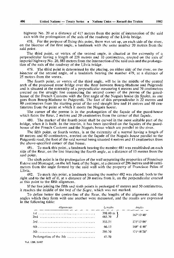
To define better the centre-line of the Reur, the lengths of the alignments and the angles which they form with one another were measured, and the results are expressed in the following table:
A li/>nmvnts Lengths
1st .................................... 398.80 m2nd ................................... 485.70
3rd .................................... 332.55
4th .................................... 66.15
5th .................................... 295.70
Prolongation of the 5th .................. 47.50
\A tltflcs
167 13 '40"
1 75" 13 '00"168 6'40"
I7I 18'20"
Vol. 1288, 11-907

1982 United Nations — Treaty Series • Nations Unies — Recueil des Traités 407
The first two angles open toward Spain and the second two, toward France.From the point determined as being the point of intersection of the centre-lines of the
Reur and the Segre the boundary goes in a straight line to the left bank of the Segre, at the end of the wall that separates the meadow of Montagut of Puigcerd from the property of Francisco Esteve of Hix.
483. Boundary-stone from the left bank of the Segre, 51 metres and 60 centimetres from number 482 on the French bank at the extremity of the said wall.
484. Proceeding in the straight line of the same wall, which forms an angle of 162 degrees with landmark 482 on the French bank, at a distance of 235 metres a boundary- marker was erected in an elbow of the wall. Here the boundary forms an angle slightly greater than 90 degrees, following the wall, which after 25 metres again makes another 90-degree angle.
485. Boundary-stone at the end of this wall, which marks the frontier 110 metres from the previous one, measured in a straight line. This line and the line between markers 483 and 484 make an angle of 170 degrees.
486. Forming an angle of 156 degrees, at a distance of 305 metres, landmark on the west side of the road from Bourg-Madame to Aja. The frontier follows the sinuous crest of the slope known as Riba de la Coma del Mas Blanch to marker 489.
487. Landmark at 438 metres, at the beginning of a depression in the slope.488. Landmark at the end of the depression, at 235 metres.489. Landmark at 267 metres, at the point where the Spanish municipal district of
Aja abuts on the French communes of Bourg-Madame and Palau.From there the international division is determined by a straight line heading almost
southward at an angle of 105 degrees and ending at the place called Riba or M rgen de las Colominas; this line was marked with three landmarks.
490. At a distance of 459 metres in the middle of the field of Coll.491. At 233 metres, on the north side of the road from Aja to Palau.492. At 142 metres, at the M rgen de las Colominas, where the straight line ends.
The border turns toward the south, making an angle of 168 degrees, and proceeds directly to the end of a wall which separates Spanish property from French property.
493. Boundary-stone at 193 metres, at the extremity of the said wall. The line makes an angle of 172 degrees, following the wall, which is almost rectilinear.
494. Boundary-stone at 270 metres, next to the wall. The walls which fence the lands mark the frontier as far as the river Lavanera.
495. Landmark at 135 metres on the right bank of the river Lavanera, opposite the place where the Rio Envolante or Vilallovent brook disembogues. Crossing the Lavanera, the line ascends Vilallovent brook for a space of 4,640 metres from its mouth to a point where the brook divides into two ravines that are not clearly marked.
496. Landmark at the meeting of the two ravines. From there the boundary climbs a large hill which comes out from the top of the Coll de Mars , passing through the following four boundary-stones connected to each other by straight lines.
497. At a distance of 171 metres, in a small clearing that separates the mass of the forest of Palau from a group of trees that remains in Spain.
498. Forming an angle of 121 degrees, at a distance of 290 metres and 12 to the north of the road from Ripoll to Puigcerd , in the place called Pallad de Dalt.
499. With an angle of 172 degrees, at a distance of 385 metres, at La Coma Tabanera.500. At a distance of 535 metres, at an angle of 177 degrees, on the summit of the
Coll de Mars .Vol. 1288. 11-907

408 United Nations — Treaty Series • Nations Unies — Recueil des Traités 1982
501. The line descends imperceptibly to the Coll de Mars , where, at a distance of 139 metres, a boundary-marker was set up on the north of the vestiges of the road from Ripoll to Puigcerd . The international line continues to the Coll de la Cruz de Mayans along the northern edge of the said road; however, as the road is a mule-track and its course is poorly defined and subject to change, the following six landmarks were placed at its most conspicuous bends in order to establish the frontier permanently:
501. I. At 500 metres from the Coll de Mars .501. II. At 300 metres.501. III. At 600 metres.501. IV. At 390 metres.501. V. At a distance of 450'metres.501. VI. At 310 metres.502. At the Coll de la Cruz de Mayans, at 660 metres. From the Coll de la Cruz de
Mayans the frontier proceeds constantly along the summits of the great spur that runs off from the peak of Eina, belonging to the principal range of the Pyrenees.
503. From the Coll de Mayans the line ascends in a north-easterly direction to the summit of the Bagarret de Mayans, where a landmark was placed at 540 metres.
504. Continuing in almost the same direction, it passes through the Coll de San Salvador and arrives at the highest point of the tableland of Coma Morera, where a land mark was placed at 550 metres.
505. Turning toward the east and crossing the Pl de la Ovella Morta, the frontier goes to the Pl de Salinas, a conspicuous pass through which the road from Doria to Vallcebollera passes. Boundary-stone 20 metres to the east of the road, in alignment with the heights that dominate the plane of Salinas, one to the east and one to the west.
506. After a number of bends, the line proceeds to the Coll dels Lladres, through which a path from Valceboll re to Caralps passes, and a boundary-stone was set up on a small rise 10 metres to the west of the path. Immediately thereafter is the peak of the Paso dels Lladres, and, continuing along the crest of the spur, which is steeper there, one arrives, without encountering any passage, at the summit of Puigmal, one of the highest mountains in the Pyrenees.
507. After passing this peak and that of Segre, the frontier descends to the Coll de Llo or de Finistrellas, where a cross was cut into the vertical face of a rock, facing east, some 120 metres distant from the path and 7 from the watershed, on the French slope.
508. The boundary climbs up the peak of Finistrellas and reaches the Coll de Eina or de Nuria, where a cross was made on a near-horizontal surface, approximately 100 metres to the east of the path and on the divide.
From there it ascends to the Pico de Eina, part of the principal chain of the Pyrenees, along which it continues to the Coll de las Masanas (marker number 524).
Though the divide, which also divides the two States, is naturally well determined, a number of boundary-markers were none the less placed on it, as stated below:
509. Cross on the Coll de Nou Fonts, on an inclined surface looking north, 20 metres to the west of the road.
510. The frontier passes the peak of La Fosa del Gegant (Gigante) and reaches the Coll de las Tr s Creus, on which a cross was carved on an inclined surface looking east, to the west of the pass, 6 metres from the watershed on the Spanish side.
511. After one has passed by the first Pico de La Vaca, the Coll dels Llachs de Carens , or de las Arenas, the second Pico de La Vaca, the Pico del Infierno or dels Gours, the Coll de la Coma del Infierno, the Pico del Gigante or dels Bastiments and the
Vol. 1288. 11-907

1982______United Nations — Treaty Series • Nations Unies — Recueil des Traités______409
Pico de la Donya, one reaches the Portella de Murens or Mantel, where a landmark was erected to the east of the path.
512. The line follows the crest of the sierra of Camp Magre to Roca Colon, on which a cross was carved on a vertical surface looking toward the south, on the edge of a precipice.
513. Via the Puig de la Pedra Dreta it goes to the Coll del Pal, in which a land mark was placed on the west side of the road.
514. It continues through the peak of Costabona and along the crest of La Solaneta and that of Finistral or Manarrassous and drops down to the Coll de Si ra or Sisern, in which a landmark was placed 2 metres to the east of the path.
515. It continues along the crest of Siern or Espinabell, passes the Puig de l'Artiga de Francia and the Puig de l'Artiga del Rey and descends to the Coll Pragon, where a land mark was erected 5 metres to the west of the path.
516. Via the Puig de la Clapa and the Basses de Fabert it reaches the Collada de Prats, where a landmark was placed next to the road, 25 metres to the west of a pool which flows into Spain.
517. It passes through the sierra of La Collada de Prats to the Coll de les Boires, and there a cross was carved on the boundary-line on a near-horizontal surface, approxi mately 120 metres to the west of the lowest point of the Coll.
518. Next it goes via the Puig del Hospitalet or de las For as to the Coll Pixados, and a cross was carved on the near-horizontal surface of a rock in a small depression in the land to the east of the Coll.
519. The Sierra de Montesquiu or Solana de Sinroles leads to the Coll de Arres, where a landmark was placed 8 metres to the west of the path.
520. The boundary-line follows the sierras of Montfalg s and of El Brus Cremat; it passes the Coll de les Moles, and reaches the Coll de Bernadell, where a cross was carved on the vertical northern surface of a very large isolated rock 10 metres east of the path.
521. Passing via the Roca del Tabal, one reaches the Coll de Malrems, on which a boundary-stone was erected 4 metres to the west of the pass.
522. The Sierra de la Bague de Bordeillat or Serr t de Coma Negra leads to the Coll de las Falgueras, where a landmark was placed on a small eminence 10 metres to the west of the road.
523. Passing the Coll of El Paret, that of Pragon, that of Llistona and that of Boix, one comes to the Pl de la Muga, where a boundary-stone was placed 50 metres to the east of the path and 13 metres from the edge of the precipice of La Muga.
524. The line runs along the crest of Sierra Llovera to the Coll de las Masanas, on which a cross was made in the near-horizontal face of a rock situated 10 metres to the west of the lowermost point and 8 metres to the north of a nearly vertical escarpment. The demarcation follows the watershed to the Puig de las Masanas, at which point it leaves the summit of the principal Cordillera and proceeds to the Rio de la Muga, passing through the following ten boundary marks:
525. Cross on the horizontal surface of the peak which is on the crest of the Serr t de las Masanas, immediately after the Puig of the same name.
526. Cross at 200 metres on the horizontal face of a rock at ground level, situated at the starting-point of a change in slope of the crest of the said Serr t.
527. After a change in direction toward the south-east, cross at 200 metres, facing south, on a rock of the bare, craggy ridge of Las Masanas.
528. Cross at a distance of 190 metres and 15 from the right bank of the stream of Las Masanas, on an inclined face looking east.
Vol. 1288, II-907

410 United Nations — Treaty Series • Nations Unies — Recueil des Traités 1982
529. Across the stream, cross at 210 metres on the horizontal surface of a rock on the great craggy ridge of the Serr t Banad s.
530. Cross at a distance of 100 metres on the horizontal surface of a large rock on the same ridge, 20 metres from the right bank of the stream of Las Castanedas.
531. Cross at 80 metres on the horizontal face of a large stone situated 60 metres from the left bank of the stream of Las Castanedas and 12 metres to the south of the house known as Can Toni.
532. Vertical cross at 80 metres, at the foot of a rock cliff, 3 metres to the north of the path which leads from Can Toni to La Muga de Dalt.
533. The line proceeds to the right bank of the stream of El Sola, where a cross was chiselled 200 metres from the preceding marker on a horizontal surface above a small waterfall.
534. Descending the stream of El Sola, at a distance of 300 metres one encounters its confluence with the Rio de la Muga, at which point a cross was carved on a horizontal surface.
535. Descending also the Rio de la Muga, at 280 metres the same number was sculpted on the interior vertical face of each of the two stones which project upward from the middle of the parapets constructed on the bridge of the mill of the Muga.
536. Continuing the descent along the same stream, after 4,300 metres one reaches the junction of the Rio de la Muga with the stream of La Blada, at which place a cross was made on the left of the river on an inclined face looking south.
537. The frontier ascends the stream of La Blada for a distance of 90 metres, and at that point, on the left bank, a vertical cross facing south-west was carved. The boundary leaves the stream of La Blada and takes a notable crest of rocks, running along it to the peak of En Roger (marker number 541).
538. Cross at 73 metres at the Portella de Juan Gurmant, on the left side of the path which descends to the Muga.
539. At 300 metres, cross at Portella de Puig Comte, to the east of the path which goes to the Muga, on an inclined surface which faces west.
540. Cross at 120 metres, at the Portella de Graus Sagulla, on the vertical surface of a northward-looking rocky cliff, on the right edge of the path which descends to the Muga.
541. Landmark at the top of the peak of En Roger, 340 metres from the Portella de Graus Sagulla.
542. From the peak of En Roger the frontier goes straight to the river Mayor, at a point where a cross was carved to the left of the river, on the inclined western face of a crag below the Era de los Monjes, opposite the confluence of the Canales de En Roger.
543. The international line ascends the river Mayor to its origin in the Coma de Horts or del Torm, where a cross was made on an inclined surface looking south. The frontier proceeds straight to the highest peak of the Serr t de la Collada Demproy, known as Puig de la Creu del Canonge, situated on the ridge of the Pyrenees, which the line follows as far as the Ras de Mux , which is beyond cross number 553.
544. Landmark at 100 metres, at the summit of the Puig de la Creu del Canonge.
545. Landmark at the Coll de la Pedra Dreta, 3 metres east of the road.
546. Landmark in the Pl de Mont Capell, on the left side of the path from Coustouges to Montalba. The boundary continues along the ridge of Mont Capell, which marks the watershed.
547. Cross at 261 metres on the inclined, southward-looking surface of a rock belonging to a craggy group rising up in the Camp de Pom .
Vol. 1288, 11-907

1982 United Nations — Treaty Series • Nations Unies — Recueil des Traités 411
548. On the most prominent height of Serr t de la Font de la Nantilla a cross was carved at a distance of 178 metres on the vertical southern face of a rock.
549. Boundary-stone at 282 metres, on the highest eminence of Serr t de la Falgarona.550. Landmark at 248 metres, at the Corral de la Falgarona, 50 metres to the north
of the house of that name.551. Continuing along the Puig Mux , the line descends the Collada Pragonda, where
a landmark was placed.552. It passes through the Puig de la Collada Pragonda and the Serr t del Cornell to
the Coll del Faig, where a landmark was placed to the south of the path.553. The boundary passes through the Puig del Turn and the Collada Verda, and
descends to the Coll de Perill , where a cross was cut into the vertical face of a crag 30 metres to the east of the lowest point of the Coll and 5 metres inside Spain. The boundary follows the crest of the Pyrenees through Pl Juvenal and Roch de la Campana to the highest point of the Ras de Mux , from which it descends somewhat down the northern slope in order to leave the sanctuary of Salinas in Spain; to do so it goes along the crest of a spur that juts out from the Ras de Mux , passing through the Collada del Pons, the Puig de las Pedrisas and Puig del Engany del Llop, whence it descends along a rocky ridge to the next marker.
554. Cross sculpted on the inclined southern face of a crag situated on the left bank of the Rio de las Illas, at the Salt del Aiga. From the Salt del Aiga the line ascends to the highest point of the Puig del Faig de Francia, from which it again follows the principal chain, along the crest of which it continues constantly up to marker 567, at the entry to the Col de Panis s.
555. From the Puig del Faig de Francia it crosses the Pl de la Pastera to the Puig of the same name, along the eastern slope of which it descends, and half-way down the slope a cross was chiselled on the southern face of a rock.
556. Via the Collada Verda and the Serr t Palat the boundary reaches a point on the Sarrat at which a cross was made, at 400 metres, on the vertical eastern face of a rock.
557. It descends to the Coll de Lli, where a landmark was placed on a knoll at a distance of 354 meters.
558. Landmark at the Pl de la Llosa, on the western edge of the road which goes from Labajol to Las Illas.
559. Continuing along the Puig de Sangl s, one comes to the Coll de Maurellas, where a cross was carved in the vertical northern face of a rock, to the south of the path which leads from Agullana to Las Illas.
560. Passing the Puig de Prunes, the line descends to the Pl Fariol, where a vertical cross was marked, facing south on an isolated rock to the south of the lowest point of the Coll.
561. Boundary-stone in the middle of the Coll de la Closa de Juan P re.562. Boundary-stone at the Coll del Portell, on the east side of the path.563. Via the Pl del Par s, Puig Calmella and Pl del Capita the boundary proceeds
to the Coll del Tax , where a cross was carved on the nearly horizontal face of an isolated rock to the west of the pass.
564. Passing through the Puig del Coll del Tax , one reaches the Coll del Pomer, and there a landmark was placed.
565. The boundary goes to the Coll del Priorat via the Puig de la Parraguera, the Paraguera de Baix and the Puig de la Bateria Espanola. Landmark at the Coll del Priorat, on the west side of the path.
566. Vertical cross facing north-west on the Puig del Priorat.Vol. 1288, II-907

412 United Nations — Treaty Series • Nations Unies — Recueil des Traités 1982
567. At the entry to Coll de Panis s, to the west of the ruins of the hermitage, the boundary is marked by a pyramid erected in 1764, at the beginning of the military zone of the fort of Bellegarde, and restored and numbered to continue the series of boundary marks of the general demarcation. The frontier, leaving the crest of the Pyrenees, follows the contour of this zone, determined by the following boundary marks, joined to each other by straight lines up to number 575.
568. Pyramid erected in 1764 on the southern slope of the Pyrenees below the redoubt, at a distance of 37 metres from it and 255 from the preceding marker.
569. On the straight line joining pyramids 568 and 570 and forming an angle of approximately 144 degrees with the previous direction, a small landmark was placed at the Coll del Cementiri, 9 metres and 50 centimetres from the wall of the cemetery of Belle- garde and 101 metres from the preceding marker.
570. Restored pyramid 54 metres from the south-western salient of the covered road of the advanced fortalice of Bellegarde and 209 metres from number 569.
571. Restored pyramid 109 metres from the preceding and 54 from the south-eastern salient of the covered road of the fortalice. The boundary between the States turns toward the north at an angle of approximately 130 degrees, running in a straight line to two identical tall pillars erected one on the right and one on the left side of the road from Barcelona to Perpignan, both 20 metres from the northern extremity of the respective parapets of the bridge on the said road, and on that line the following two pyramids were now built:
572. The first, 17 metres from the preceding.573. The second, 205 metres further, situated near the middle of a craggy ridge
which descends from the fortalice to the highway.574. First large pillar with the inscribed date 1764 and with the restored coats of
arms of Spain and France, erected on the west side of the highway.575. Second pillar on the opposite side of the road.576. The international line ascends along the outside edge of the ditch running along
side the highway on its eastern side to a path which runs into it; the straight line going from there to the foot of the slope bordering the roadway to the north of the bridge on the same road, over the stream of La Condesa; the foot of the said slope to the point where the ditch begins again; the eastern bank of the ditch to a landmark bearing the number 9, set up by the French; and finally, the straight line connecting that landmark to the vertex of the pyramid of 1764 situated in the bottom of the stream of La Condesa at the corner of the gardens of El Pertus, 474 metres from the pillars on the north of the bridge.
577. The boundary follows the stream of La Condesa as far as a restored pyramid on its left bank, 140 metres from the previous one.
577. I. It continues along the same stream some 200 metres to a modern pyramid on the left bank.
578. From that point it proceeds in a straight line of 45 metres to a pyramid of 1764, called Pil de Baix or del Coll de Latour, situated on a small rise on the principal crest of the Pyrenees.
579. Thereafter it proceeds in a straight line along the said crest to another pyramid of the same period, at a distance of 198 metres, set up at the beginning of the sierra of Puigmal. The frontier follows the crest of the Pyrenees, which runs to the Cova Foradada, on the shore of the Mediterranean, passing through the following notable points:
580. Coll de la Condesa, in the sierra of Puigmal, with a landmark 3 metres to the south of the road.
581. Pico de la Pouge and Pla del Area, where a boundary-stone was placed on the west side of the road.
Vol. 1288, 11-907

1982_____United Nations — Treaty Series • Nations Unies — Recueil des Traités______413
582." Puig dels Homes, peak of LJobregat and Coll Furcat, at which a horizontal cross was carved on an isolated rock, 6 metres to the west of the road to Recasens.
583. Puig de Piny , Coll Furcadell, Puig de las Colladetas, Coll de Pal, Roch dels Tr s Termes, Puig Neul s and Pla de la Tanyareda, where a vertical cross was carved, facing north.
584. Puig Pragon, Coll Pragon, Puig del Talayador and Coll del Faig, at which a cross was made on an inclined face looking east, 15 metres from the path.
585. Pla del Fum and Coll de Lorry,* where a northward-facing cross was cut 35 metres to the west of the path which descends to the Garriga.
586. Puig de las Basses, Ras de la Menta and Coll de la Estaca. Cross on the eastward-looking inclined face of a rock situated in the Coll, to the west of the road.
587. Puig Paradet, Collada dels Emigrants, Puig des Cuatre Termes, Roch de la Canal Grossa and Collada de la Font de la Masana, at which a cross was carved on an inclined surface, oriented toward the west, 20 metres to the east of the pass.
588. Puig de la Carbasera, Coll of the same name and Coll de Tarr s. Horizontal cross at the Coll on a small rock at ground level, 35 metres to the east of the passage.
589. Level mountain to Coll del Pal, at which a vertical cross was made, facing east, on the rock of Saint Eulalia, to the west of the road.
590. Serr t de Castell Serradill and Pla de las Eras, where a vertical cross was made, facing west, 15 metres to the east of the path.
591. Pico de Estella, Puig des Barrets and Coll del Pastor Mort. Here a cross was placed on an inclined surface looking toward the north, to the east of the path.
592. At the Coll de Banyuls, horizontal cross at ground level, on the eastern edge of the path.
593. Coll Sabens, Coll del Llop, Puig de la Calma and Coll del Turn, where a horizon tal cross was hewn 10 metres to the west of the path.
594. Ras de la Perdiu, Puig den Jurd and Coll del Tax or den Jurd , at which a vertical cross was carved on the western face of an isolated rock, 50 metres to the east of the road.
595. Puig de Barba de Boch and Coll dels Empedrats. Cross at the Coll, on the vertical northern face of a crag, and to the east of the gap that constitutes the pass.
596. Coll de Tarbaus. Cross on the northward-looking, inclined face of a large rock, 50 metres to the west of the path and 6 metres inside France.
597. Pla de Ras. Cross on the vertical western face of a rock, 20 metres to the east of the pass.
598. Torre de Cap Roig and Coll de la Farella, and at the latter: vertical cross, facing north, 60 metres to the east of the path.
599. Puig Rudona and Coll dels Frares, at which a vertical cross was carved, facing south.
600. Puig dels Frares and Coll dels Belitres.** Vertical cross facing north in the middle of the Coll, 5 metres to the east of the pass.
601. Puig de las Fresas. Nearly vertical cross on the eastern face of a rock situated at the summit of the peak. From this summit of the cordillera the frontier descends along the craggy ridge of the steep coast of the Mediterranean to the cave known as Cova
* In the Spanish editions it says "Coll de Horry", but this must be a copying error, because on the French maps .M. Vec.) this also reads "Col de Lory".
** On different maps: "Balistres, Coello, Belliustre".Vol. 1288, 11-907

414 United Nations Treaty Series Nations Unies Recueil des Trait s_____1982
Foradada, situated on the edge of the sea, between the Punta del Osell, which is in Spain, and Cap Cerb re, in France.
602. Inside the Cova Foradada, on its vertical wall on the land side, at a height of one and one half metres above the ground, a cross was made. This grotto is the eastern extremity of the boundary line between Spain and France.
SECTION TWO. DEMARCATION OF THE ENCLAVED DISTRICT OF LLIVIATo mark the limits of the jurisdictional district of Llivia, use was made of crosses and
landmarks bearing the appropriate serial number. The crosses are in all respects the same as those described in section one of this Act; the boundary-stones, however, are only 60 cen timetres high, and the unequal sides of their base measure 30 and 35 centimetres, respec tively; in addition, these landmarks have an "LL" carved on the side facing Llivia and, on the opposite side, the initial of the name of the French village conterminous on that side.
Number 1. The first landmark is situated on the north-western side of the road from Puigcerd to Llivia, at the place called Pontarr de Xidosa, next to the old stone which served as a boundary-marker between Llivia, Ur and Caldegas. As was done in the demarcation from the Valley of Andorra to the Mediterranean, angles are measured with respect to the direction that was being followed, and distances, from the preceding boundary-mark, unless otherwise specified. The first line of the perimeter forms an angle of 45 degrees with the said road and ends at the Moj n (landmark) den Punyet, which bears the number 3. As a general rule, the border proceeds in a straight line from one boundary-marker to the next, except where stated otherwise.
2. Landmark in the said direction, at 480 metres, at the Paso dels Bous, near the wall which on the west borders the road from Llivia to Onz s.
3. At 302 metres, at the site of the old Moj n den Punyet, a new landmark was established 20 metres from the right margin of the river Segre.
4. The frontier passes the Segre, forming a re-entrant angle of 150 degrees, and follows the rural road known as the Pas dels Bous de Campo Ras or Paso de la Borda, and a boundary-stone was erected at 180 metres, to the east of an elbow in the road. Making a salient angle of 122 degrees, the frontier climbs up the slope of the Riba de Campo Ras.
5. Landmark at 21 metres, at the eastern extremity of the Riba de Campo Ras.6. Landmark making a re-entrant angle of 147 degrees, situated at 850 metres, at the
limit between Caldegas and Santa Leocadia, in the Sierra de Concellabre, at the place called Bach de Onz s.
7. Landmark in the place of another old one in the Sierra de Concellabre, at 300 metres, at which point a salient of 178 degrees is thus formed.
8. Salient angle of 156 degrees over the top of the plateau; landmark at 1,115 metres in the sierra of Santa Leocadia, at the place called Pell de Can, 110 metres to the west of the road from Mas Palau to Gorguja.
9. In the same direction, boundary-stone at a distance of 406 metres in the part of the Sierra de Santa Leocadia called Sierra de Balcedolla, on the eastern edge of the road from the chapel of Saint-Etienne to Gorguja. The border forms a salient angle of 161 degrees, and in that direction are found landmarks 10 and 11.
10. At 308 metres, in the sierra of Picasola.11. At 278 metres, on the upper edge of the Riba de Picasola, bordering on Santa
Leocadia and Sallagusa.12. After an oblique descent down the Riba de Picasola, making a re-entrant of
160 degrees: landmark at 300 metres next to the wall of the Carbonell meadow, approxi mately 70 metres from the left bank of the Rio de Err.
Vol. 1288, H-907

1982______United Nations — Treaty Series • Nations Unies — Recueil des Traités______415
13. At an angle of 107 degrees, the line follows the same wall until it reaches the R o de Err and, passing that river, continues in the same direction. Boundary-stone at a distance of 160 metres, against a wall.
14. Without any appreciable change in direction, boundary-stone on the north east side of the road from Err to Gorguja, at 235 metres.
15. At a distance of 250 metres along the same road, making a salient angle of 104 degrees: boundary-stone on the north-east edge of the road.
Making a re-entrant angle of 143 degrees, the boundary proceeds direct to the place called La Font del Estany, at a distance of 360 metres, on the road from Ro to Llivia. The road serves as a boundary-line from number 16 to 21; its course, however, is so disorderly and ill-defined that it was necessary to regularize the portion of it that constitutes the boundary, forming it from two parallel jagged lines and marking the starting point and each change in direction with two landmarks bearing the same number; and the clear space of 7 metres left between the two landmarks of each pair indicates the width of the road, including the ditches; it is understood, however, that this alignment shall not be an obstacle to the rounding-off of angles wherever deemed necessary in order to facilitate traffic. The centre-line of the road shall constitute the frontier. Nevertheless, inasmuch as the upkeep of the road and ditches cannot be divided on the basis of this line, the French shall be responsible for maintenance from boundary-mark 16 to a point half-way to marker 21, and the Spanish shall be responsible for the remaining half.
The paired landmarks were set up at the following five places:16. In the place called La Font del Estany, to the north-west of the small springs
of that name.17. Making a salient of 122 degrees, at 356* metres.18. At a re-entrant angle of 160 degrees, at 660 metres. The boundary between
Sallagusa and Estavar is nearly equidistant from markers 17 and 18.19. Salient angle of 175 degrees, at 220 metres.20. Forming a salient of 175 degrees, at 165 metres.21. At an angle of 172 degrees, at 236 metres only one boundary-stone was set up at
the place called El Tarrosel, on the northern edge of the road, which from that point on ceases to mark the frontier.
21. I. Boundary-stone at 95 metres, on the summit of the Tosal del Tarrosel, which is a hillock on the left bank of the river Segre. The dividing line runs to the confluence of that river with the Astange, known further upstream as the Palmanill, and ascends it to the point at which it receives the stream that descends from the Pl de Palmanill.
22. Horizontal cross on a flat rock in the south-west corner of the junction of the Palmanill with the stream mentioned above, this point being common to Estavar and Targasona.
23. Changing direction toward the north-west, the demarcation goes in a straight line to a landmark situated at a distance of 755 metres, at the Pl de Palmanill, on the north west side of the road from Llivia to Targasona.
24. Horizontal cross at 420 metres, on the right bank of the Rivera dels Vails, 25 metres below the union of two streams which form the Rivera.
25. Landmark at a distance of 210 metres on the peak of the Tosa de Ventol , known at Targasona as Serr t del Cogul.
26. Forming an angle of 162 degrees with the line joining markers 23 and 25, at 405 metres, after the boundary passes through a group of rocks called Las Barretas or
* In the French texts: 366.
Vol. 1288, 11-907

416 United Nations — Treaty Series • Nations Unies — Recueil des Traites 1982
Bereta, a vertical, southward-looking cross was made on a rock situated in the Prat del Pou, where the territory of Angoustrine commences.
27. Forming a salient of 169 degrees, at 102 metres, cross on a large-sized rock to the north of the Prat del Key.
28. Forming a salient angle of 170 degrees, at 142 metres, pillar at Camp del Rey.29. Making a salient angle of 145 degrees, at a distance of 71 metres, cross on the
upper, near-horizontal face of a large rock.30. Horizontal cross at ground level at 160 metres, at the junction of the stream of
Vilalta with the Rech del Mas de Vilalta. The union of these two streams gives rise to the Barranco del Tudor, which marks the boundary to where it meets the rural track known by the name Carrerada del Tudor.
With a view to regularizing the alignment and width of this road over the stretch where it serves as a boundary, pairs of landmarks spaced 5 metres from one another, thus indicating the width of the road, including the stream, and both bearing the same number were placed at intervals along the road. The centre-line of the road marks the frontier. These pairs of landmarks were positioned in the following four places:
31. At the meeting of the Barranco del Tudor with the Carrerada.32. At 75 metres, in the direction of the Carrerada, at the first bend.33. At 75 metres, at another bend.34. At the western end of the Carrerada, at 330 metres. The international line leaves
the Carrerada and goes on to proceed in straight lines from marker to marker until it closes the perimeter.
35. At a distance of 454 metres to the south, boundary-stone at the Portella del Tudor, on the north side of the road.
36. Making a re-entrant angle of 117 degrees, pillar at 310 metres, at the highest point of the pass, at the place called Oratori del Puig, on the east side of the road from Angoustrine to Sareja. Proceeding at an angle of 168 degrees, one arrives at a place known as Las Esquerras.
37. In that direction, at a distance of 175 metres, a cross was chiselled, facing south, on a crag of the slope known as Serr t de Curmiers.
38. Landmark at 175 metres, dominating a rock called the Roqueta de las Esquerras.39. In a nearly southerly direction, at an angle of 126 degrees, landmark at 330 metres
in the middle of the place which had been occupied by a large stone known as Cova de la Guilla and was recently destroyed by boring.
40. At a distance of 215 metres in the same direction, cross on a rock at Las Fosas del Rey.
41. In the same direction, at 120 metres, landmark at Costa Den-Calvera, on the north side of the road from Villanueva to Llivia.
42. At a distance of 225 metres in an essential southerly direction, landmark next to the rock of the Coma del Flori or of the Camp del Pla, where the towns of Angoustrine and Ur meet.
43. Making a salient of 173 degrees, boundary-stone at 715 metres, next to the wall of the meadows of El Tudor de Flori, on the side of the road from Villanueva to Onz s.
44. At a salient angle of 174 degrees, landmark at 400 metres on the side of the road from Ur to Llivia.
45. In the same direction, last landmark at 325 metres, at the Tosal de Pedra Llarga or Peyre Llargue, which is a projection on a hillside.
Vol. 1288, U-907

1982 __ United Nations — Treaty Series • Nations Unies — Recueil des Traités______417
A straight line 585 metres in length joins landmark 45 to the Pontarr de Xidosa (number 1), and closes the perimeter, forming at Pedra Llarga a salient angle of 142 degrees and another of 126 degrees at the Pontarr de Xidosa.
ANNEX II
AMENDMENT OF ARTICLES XVIII AND XIX OF THE TREATY
The Spanish village of Guils, on the one hand, and the French communes of Porta and La Tour-de-Carol, on the other, having made known more clearly and completely their respective needs concerning the pastures situated on their frontiers, whereas the Plenipotentiaries of both countries desire to satisfy genuine exigencies in an equitable manner so as to obliterate any trace of former rivalries and guarantee peace and good relations between those concerned, have agreed as follows:
Article I. Articles XVIII and XIX of the Treaty on Boundaries signed at Bayonne on 26 May 1866 are abrogated and, in consequence, without validity or effect.
Article II. The French inhabitants of Porta shall have exclusive use of the Spanish pastures of the Fuente de Boved contiguous to France and comprised between the frontier line from Puig Pedros to the Padr de la Tosa and the rocky escarpment which runs from one of those summits to the other, forming an arc that is convex toward Spain.
Article HI. The livestock of Guils may freely graze with that of La Tour in the Tosas Bajas, which belong to the common of La Tour. These pastures are limited on the west and south by the frontier between Puig Farin s, Roca Colon and Pico de la Tosa (boundary- marks 431 to 434); on the north, by the existing division between the pastures of Porta and La Tour, from Puig Farin s to the peak called by the French Llabinet, which is marked with a cross having double bars, and on the east, by the crest of the change of slope that unites the peaks of Llabinet and La Tosa.
Article IV. French livestock shall have free passage through the territory of Guils, between boundary-marks 436, 437 and 437 I, in order to ascend or descend the Sierra de la Baga or de la Tosa and de la Cim del Bosch, but with an absolute prohibition against stopping to graze. Subject to the same condition, the village of Guils must facilitate the passage along the right bank of the stream of San Pedro, from marker 444 to 445, of live stock of La Tour en route to its pastures of La Socarrada or when returning from them.
Article V. To legitimate this state of things, which differs from the former state, and to nullify any pretension to the contrary, the French Government shall pay to Guils, within the first year of operation of this Act, a remuneration in cash, calculated in accord ance with the bases established by the experts appointed by the two Governments, representing the difference between the former state and the present state and amounting to the sum of 1,284 francs, or in other words 4,879 reals, at the rate of 19 reals per 5 francs.
ANNEX III
ADDITION TO THE DETERMINATION OF ROADS OF FREE PASSAGE'
To satisfy recognized needs and sanction existing usages, it is agreed that Spanish and French inhabitants of the frontier zone shall enjoy the necessary franchise for free circulation in the cases specified below, on the express condition, however, that they must not leave the road, which shall be absolutely prohibited to foreign agents of the public force for acts of service. These passages are:1. For Spanish and French, the Mitjana highway over its entire extent, from Tartar s
to marker number 454, including, for the French, the Spanish portion of the said road
Vol. 1288, 11-907

418 United Nations — Treaty Series • Nations Unies — Recueil des Traités 1982
from landmark 440 to 441, separated from each other by the meadows of Domingo Pons de Guils.
2. For the French, the road from Puigcerd to Ripoll, from the Coll de Mars (land mark 501) to the Coll de la Cruz de Mayans (number 502).
3. The path which the French follow in Spanish territory to go to La Man re via El Molino and El Pl de la Muga.
4. The road which takes the French to Montalba and enters Spain through the Coll del Faig, returning to France by the Coll de Perill .
5. For the French, the path which crosses the territory of the sanctuary of Salinas from the Ras de Mux to the Serr t del Faig de Francia.
6. The road frequented by the French in Spanish territory from the Coll del Pal to the Pl de la Tanyareda, between boundary-marks 582 and 583.
ANNEX IV
USAGES BETWEEN CONTERMINOUS TOWNS
Article I. Whereas the Spanish village of Set Casas and its neighbour in France, the commune of Prats de Moll , have expressed the desire that their reciprocal common of pasturage on the portion of their limitrophe pasture-lands from the Pico de Costabona to the Puig de la Pedra Dreta, over a width of 200 metres on each side of the frontier, should be sanctioned by an international accord, it is agreed that this usage, inasmuch as it is favourable to peace and the existing good relations, shall be maintained in the manner mentioned above.
Article II. The rectification of the frontier to which consent was amicably given by the Spanish district of Albany and the French commune of Coustouges in no way modifies the present state of ownership and enjoyment in the territories which have changed jurisdiction.
The livestock of Coustouges shall consequently continue to graze freely on the left bank of the river Mayor as far as the crest which runs from the summit of the Puig de la Creu del Canonge (marker 544) through the Coll de Demproy and the Roca del Falco to the mill of the river Mayor.
The livestock of Albany shall continue to be pastured freely on the right bank of the river Mayor as far as the jagged line determined by the following points: Pico de En Roger, Singl Barr t, Puig Comte, Portell Soliver and confluence of the ravine of the Camp de Arnau and the river Mayor.
Article III. If the fishermen of the municipal districts of Culera or Banyuls are driven by the current or by any maritime accident into foreign waters, they may freely withdraw their nets up to one kilometre from the frontier, unless fraudulent intent is evident.
ANNEX V
RELATIVE TO THE SEIZURE OF LIVESTOCK, PURSUANT TO ARTICLE XXX OF THE TREATY
To avoid the disputes and excesses to which the lack of any agreement concerning the seizure of livestock has long given rise on the frontier and to make up, where necessary, for the absence of regulations governing the manner of proceeding when a flock or herd
Vol. 1288, 11-907

1982 United Nations — Treaty Series • Nations Unies — Recueil des Traités 419
illicitly enters an alien district, the Plenipotentiaries of both nations have agreed to estab lish the following rules:
Article I. Aside from the public force, the sworn guards shall alone have the right to make seizures of livestock which, coming from one of the two countries or the common pasture-lands, unduly enters the pastures of the other country or remains at night in those which are common, in violation of the existing conventions.
Article II. The designation of guards shall be made in each valley or village in accord ance with its own usages and customs; and whenever such appointment takes place, the mayor of the district shall notify the conterminous municipalities of the neighbouring nation concerning the persons chosen, so that they may be recognized in the exercise of their duties; in addition, the guards shall wear a badge peculiar to their charge.
Article III. The word of these guards, given under oath, shall, in the absence of proof to the contrary, constitute evidence before the authorities of the district in which they are sworn.
Article IV. The owners of the transgressing livestock shall be subject to the penalties established between the conterminous municipalities. Where no convention exists, the violators shall pay one real per head for small livestock (sheep and goats) and ten reals per head for large livestock (cows, horses, oxen and mules), the young of such animals not being included in either case for the determination of the number. If the infraction takes place at night, the penalty shall be doubled; however, if it takes place in common pasture- land in a period when its use by the transgressing livestock is permitted in the daytime, the penalty shall be single.
Article V. From every flock or herd which unduly enters alien pasture-lands, one head shall be taken for every ten, whether large or small, to answer for the fine and costs.
Article VI. The animals taken shall be transferred by the guards to the nearest village of the valley in whose jurisdiction the seizure is effected, and the mayor of that village shall without delay notify the mayor of the residence of the owner of the live stock by means of an official letter in which he shall state the circumstances of the seizure and the name of the herdsman or owner of the livestock, in order for the owner, duly advised, to appear in trial, personally or by proxy, on one of the ten days following the seizure.
Article VII. If the legitimacy of the charge is proven, the owner of the seized live stock shall be required to pay, in addition to the fine established in article IV, the costs incurred for feeding and keeping the animals while impounded and for messengers and notices required by the judicial proceedings.
The cost of feeding and keeping to be paid shall be one real de vell n per head for small livestock and five reals per head for large livestock for each day. The messengers who carry the notices of the authorities shall be paid two reals per hour of travel, both going and returning.
If it is deemed appropriate to grant a pecuniary recompense to the guard who effected the seizure, it shall be deducted from the amount of the fine and shall not entail any greater costs for the transgressors.
Article VIII. Should the owner of the livestock fail to appear before the expiry of the period of ten days, the authority shall openly proceed on the following day to sell the impounded animals by public auction in order to pay, with the proceeds thereof, the penalty and costs. Any surplus shall remain at the disposal of the owner for one year; and if it is not claimed within that time, it shall be used for public charity in the municipal district in which the auction was held.
Article IX. If the seizure was made unduly, the impounded animals shall be returned to the owner and, in case any is missing due to loss or death as a result of mistreatment or negligence on the part of the depositary, its value shall be paid. A guard who effects
Vol. 1288,11-907

420 United Nations — Treaty Series • Nations Unies — Recueil des Traités 1982
an improper seizure must return the animals to their flock or herd and pay the expenses of feeding and keeping and any costs incurred.
Article X, The preceding provisions shall not derogate from any conventions on this subject entered into between the frontier municipalities, nor shall they stand in the way of the conclusion of new covenants modifying the stipulations of this annex; it is under stood, however, that seizures shall under no circumstances be made otherwise than by sworn guards and that any new accords reached must, pursuant to article XXIX of the Treaty, be limited to a determinate period, which in each instance shall not exceed five years, and be submitted previously to the approval of the higher civil authority of the province or department concerned.
PART TWO
REGULATIONS CONCERNING THE ENJOYMENT OF WATERS USED IN COMMON BETWEEN THE TWO COUNTRIES
These regulations were drawn up, pursuant to articles VI, XX and XXVII of the Treaty on Boundaries of 26 May 1866 and articles XIII, XVIII and XIX of the additional instrument of the same date, by an International Commission of Engineers composed: with respect to Spain, of Don Inocencio G mez Rold n, Chief Engineer of Roads, Canals and Ports and Vice-Secretary of the Consultative Board thereof, and Don Federico Peyra, First-Class Regular Engineer, of the province of Barcelona; and, with respect to France, of Mr. Auguste Labb , Chief Engineer of the department of the Pyr n es-Orientales, and Mr. Joseph Bauer, Regular Engineer of the district of Prades, replaced after the demarcation of the bed of the Reur River by Mr. Alfred Pasqueau, Regular Engineer of the district of Perpignan; and the insertion of the said regulations in the second part of this Final Act is intended to give to them in both States the same legal force as to the provi sions contained in the first part, through the promulgation of the said Instrument to be effected in each of the two nations.
I. DEMARCATION OF THE BED OF THE REUR RIVER
The centre-line of the Reur River being perfectly determined and marked, as explained in the Record of Demarcation, from boundary-mark 477 to 47 metres and 50 centimetres beyond landmark 482, the bank alignments were traced, comprising between them the zone in which it is prohibited to do planting or execute any other kind of works.
The said alignments were established at a distance of 8 metres on each side of the centre-line and parallel to each other, except in the proximity of bridges, where they deviate in divergent straight lines until they meet the abutments of those structures, at a distance of 50 centimetres from their interior face.
The widening of the bed of the river downstream from the Llivia bridge ends 83 metres from the middle of the vault of the central arch of the bridge.
The widening upstream from the proposed Bourg-Madame bridge begins 83 metres from the middle of the central arch, boundary-mark 480; and the widening downstream ends 66 metres and 15 centimetres from the same point, at the straight line uniting the two landmarks bearing the number 481. These three distances are measured along the centre line of the river.
With respect to the regulation of the river, the following has been agreed:I. It is prohibited to establish plantations or works of any other nature in the zone
comprised between the alignments defined above. All parts of works or plantations now existing within that zone must be destroyed by riparians on their respective properties within a period of three months from the date on which the General Record
Vol. 1288, 11-907

1982 United Nations — Treaty Series • Nations Unies — Recueil des Traités______421
of Demarcation of the frontier is put into effect. Once that period has elapsed, this operation shall be undertaken by the authorities, at the expense of the violators.
2. Riparians shall be permitted to maintain, repair and consolidate existing dikes, provided that they give prior notice to those on the other side in order to enable them, if they so desire, to watch over the operation and prevent damage that might be caused them and to forestall intrusions into the zone reserved for the bed of the river.
3. To establish new dikes, whether in parts of the river where they are needed or in front of existing dikes situated behind the new alignments, riparians shall be required to obtain proper permission from the competent local authorities and, in such cases, the proprietors on the opposite bank must be notified so that they may put forward such observations as they deem necessary.
4. Structures executed on either side in order to fix and preserve the banks must be placed either perpendicular or parallel to the axis of the river, as provided in the con vention of 1820.
5. In order to prevent the abuses that have sometimes been committed by riverains of both countries, it must be borne in mind, in accordance with a provision of the Act of 1750, that none of them shall have the right to take either stones or sand from the bed of the Reur River, except in front of their property and up to the centre or axis of the said river.
6. It is absolutely forbidden for all proprietors, whether riparian or not. to make cuts or any other means of diversion in dikes or banks without proper authorization. Those who possess diversions of this kind shall be required to have their situation regularized by the competent authorities of their country within a period of three months from the date on which the general Treaty of demarcation of the frontier is put into operation. It is likewise prohibited for all proprietors, whether riparian or not, to spill into the bed of the river tainted or insalubrious waters.
7. Every five years, in the month of August, the higher authorities of the province of Gerona and the department of the Pyr n es-Orientales shall come to an agreement concerning the appointment of delegates who shall proceed to verify the alignments of the banks of the Reur, and wherever plantations or other works exist on the bed of the river determined by those alignments, they shall be destroyed immediately by the violators, and, in case of refusal on their part, such destruction shall be undertaken at their cost by the authorities.
II. FUENTE DE BOVED
Inasmuch as the International Commission of Engineers deemed that the regulation of a water intake in a place to which access is so difficult would without a doubt be completely illusory and that distribution by time would be unfeasible because of the great distance between the intake and the inhabited areas, expressing the opinion, in consequence, that it should not adopt any decision on this matter, it was agreed that the solution should be left to the two Governments, if in the future it were recognized as indispensable for preventing conflicts between those concerned in the two countries.
III. REGULATION GOVERNING THE USE OF THE WATERS OF THE RIU TORT AND THE RIU TARTAR S
Article I. The inhabitants of Guils shall alone have the right to divert the waters of the river Tort by means of ditches diverted at a distance of at least 550 metres upstream from the point where this torrent cuts the frontier line between boundary-marks 440 and 441.
Article II. The inhabitants of Guils shall not have the right to take the waters of the Font-Talabart or of the river Tartar s or its affluents, and all structures built for that
Vol. 1288, 11-907

422 United Nations — Treaty Series • Nations Unies — Recueil des Traités 1982
purpose must be destroyed, as well as the open ditches downstream from the point indicated in article 1 above, within a period of three months from the date of promulga tion of this regulation.
Article HI. If, once those structures have been eliminated, the inhabitants of the frontier towns of Saneja and La Tour do not succeed in reaching an amicable understanding concerning the distribution of the waters of the river Tort and the river Tartarcs, partly diverted by the canal of San Pedro, such regulation shall be undertaken in accordance with the rights of the users of both countries by the governor of Gerona and the prefect of the Pyr n es-Orientales, in accordance with what is proposed by the engineers appointed for that purpose by the said authorities.
Article IV. If, after the lapse of the time-limit set in article II, the said structures have not been eliminated, the governor of Gerona shall, after notifying the prefect of the Pyr n es-Orientales, immediately order the official execution of the work prescribed in the said article, which shall be carried out in the presence of the mayors of Saneja and La Tour-de-Carol.
IV. REGULATION GOVERNING THE USE OF THE WATERS OF THE CANAL OF PUIGCERDÂ
Article I. The distribution of the waters of the canal of Puigcerd between Spanish and French users shall be as follows: all the water of the canal shall be destined for uses of all kinds of the town of Puigcerd and the irrigation of its lands every day for 12 hours, from 4 o'clock in the morning to 4 o'clock in the afternoon. All the water of the canal shall be destined for the irrigation of the lands situated in French territory every night for 12 hours, from 4 o'clock in the afternoon to 4 o'clock in the morning.
Article II. The minimum rate of flow of the canal at its origin is fixed at 300 litres, If, as a result of a shortage of water in the river upstream from the dam, the flow in the canal is lower than the said minimum, the number of hours allotted to Puigcerd shall be increased so that the volume of water received in 24 hours by the Spanish users approxi mately equals the yield of a continuous flow of 150 litres per second.
For that purpose, the flow of the canal shall be evaluated by means of a measuring weir established 20 metres downstream from the origin. The weir shall have a width of 3 metres and shall be of ashlar masonry; both the base and the vertical sides shall consist of a straight part measuring 5 centimetres, parallel to the axis of the canal, and another, bevelled, part 35 centimetres long by 20 centimetres high, forming a funnel facing upstream. The base and sides of the weir shall be at a distance of at least 40 centimetres from the walls and floor of the upstream reach of the canal. The sill shall be placed at least 60 centimetres above the floor of the downstream reach of the canal.
One metre upstream from the weir, there shall be carved, on an ashlar embedded in one of the walls of the basin, a gauge graduated as indicated in the following table:
Height of lines nbnrc Number of gradiintion line the ed^e of the irt'/V
Line number 12 ............................... 0.147 m
Line number 16 ............................... 0.122Line number 20 ............................... 0.105
Line number 24 ............................... 0.093
When the level of the upstream reach attains or passes line number 12, distribution between the users of the two countries shall be in accordance with article I above.
If, in consequence of a shortage of water in the river, the flow in the canal decreases to a sufficiently great extent for line 16 to appear above the water level during three
Vol. 1288, 11-907

1982 United Nations — Treaty Series • Nations Unies — Recueil des Traités______423
consecutive days, the period allotted to Puigcerd shall be increased from 12 to 16 hours and shall begin at midnight.
If line number 20 appears under the same conditions, the period reserved for Puig cerd shall be increased to 20 hours, starting at 8 o'clock on the previous evening, and similarly in the case of graduation number 24, starting from which all the water in the canal shall belong to the Spanish users.
Article III. Each of the French communes of La Tour-de-Carol and Enveix shall have the right continuously to divert a volume of five litres of water per second in order to satisfy their needs of all kinds. The inhabitants of the districts crossed by the canal may also, and at all times, employ the water for domestic uses, for watering their live stock and in case of fire.
Article IV. All water intake orifices created in France on the canal must be made in ashlar stones embedded in masonry walls whose foundations shall form a banquette of 20 centimetres from the side of the canal, and the said orifices shall be made flush with the floor of the canal. These intake devices shall be constructed at the expense of the users who employ them, and the gates shall be disposed in such a way that they close the orifices as hermetically as possible during the time reserved for Spanish users. The present number of intakes, which is 148 in French territory, shall not be increased without author ization from the town of Puigcerd , the owner of the canal.
Article V. In regulations made in future for the distribution of the water among the French users, care shall be taken, in so far as possible, that irrigation shall take place from upstream to downstream.
Article VI. It is forbidden to obstruct the canal; however, French users may set up in it movable dams to channel the water into their intakes during the time allotted to them. Such dams must remain completely open during the time reserved for Spain and provide an outlet equal to that of the canal.
Article VII. The standard width of the land zone to be occupied by the canal and its banks is fixed at 6 metres and 50 centimetres; in case the strip of land belonging to the town of Puigcerd is at some points smaller than that figure, the town may, at its own expense, acquire from the adjacent private properties the land necessary to make up the said width, complying with the French law of 3 May 1841.
Article VIII. The cost of maintenance and repair of the water intake dam and the entire stretch of canal situated in French territory shall be divided equally between the Spanish and French users. The cost of maintenance of the stretch lying within Spanish territory shall be borne exclusively by the Spanish users.
Article IX. The Spanish and French shall have the right, each for their own part and at their own expense, to appoint guards or canal tenders to watch over the execution of articles III and VI above and to report any person who infringes the rights of the users. Such guards, provided with the document that accredits them, shall take an oath before the competent authority in France, where their supervision is to be carried on. If it is to be carried on in Spain as well, the guards appointed for that purpose by the users and provided with the document that accredits them must take an oath before the competent Spanish authority. The guards shall present their written reports to the Commission mentioned in the following article, to be transmitted by it to the proper quarter.
Article X. An International Administrative Commission, the organization and functions of which are set out in the regulation which follows under number V, shall see to it that the rights of the two nations are respected and adopt the administrative and police measures required by the preceding articles. It shall cause the regulating device described in article II above to be executed and shall distribute the cost equally among the users of the two countries. It shall also officially cause to be executed, at the expenses of the users, the structures prescribed in article IV above if the irrigators have not createdthem themselves within the time-limit specified in article XII.
Vol. 1288, 11-907

424 United Nations — Treaty Series • Nations Unies — Recueil des Traités 1982
Article XI. The inspection and checking of the regulatory device called for in arti cle II shall be done by a Spanish engineer and a French engineer, in the presence of the local authorities of both countries and of the persons concerned, duly summoned for that purpose. The record of inspection shall be drawn up in four copies: one shall be deposited at the office of the mayor of Puigcerd , another shall be delivered to the Administra tive Commission, and of the remaining two, one shall be kept in the archives of the civil government of the province of Gerona and the other, in the archives of the Prefecture of the Pyr n es-Orientales.
Article XII. The provisions of this regulation shall be applied as soon as possible, and within a period of two years at the latest, reckoning from their promulgation.
V. REGULATION GOVERNING THE ORGANIZATION OF THE INTERNA TIONAL ADMINISTRATIVE COMMISSION OF THE CANAL OF PUIG CERD
CHAPTER i. COMPOSITION OF THE COMMISSION
Article I. The International Administrative Commission shall be made up of three Spanish delegates and three French delegates.
Article II. The mayor of Puigcerd shall always be a member and ex officia presi dent of the Commission. The second member, who shall hold the office of vice-president, shall be the mayor of La Tour-de-Carol during even-numbered years and the mayor of Enveix during odd-numbered years.
Article HI. As to the other four members, elected from among the persons con cerned, the Spanish members shall be appointed by the Spanish users in accordance with the system of election determined by the governor of Gerona and the French members, by the French users in accordance with the system of election determined by a future decree of the prefect of the Pyr n es-Orientales. If the election does not come to fruition, the Commission shall be completed administratively by the governor of Gerona and the prefect of the Pyr n es-Orientales.
Article IV. On 31 December of each year one of the Spanish and one of the French members appointed by election shall be replaced. Outgoing members shall not be immediately re-eligible, and those who must retire the first year shall be designated by lot.
Article V. The members of the Commission may not have themselves replaced by delegates of their choice. In the event of their absence, they shall be replaced by alternate members, of whom there shall be two for each nation, elected in the same manner as the regular members.
Article VI. In case of death or resignation of a regular or alternate member, provi sion shall be made for his replacement, and the duration of the functions of the person elected shall not exceed the remaining term of the person replaced.
Article VII. The Commission shall be convoked in Puigcerd and presided over by the mayor of that town or, in his absence, by the vice-president. It may convene either at the request of two members or when called by the governor of Gerona or the prefect of the Pyr n es-Orientales.
Article VIII. Users who have committed an infraction shall not be eligible in the year in which it was committed.
Article IX. Resolutions shall be adopted by a majority of the members present. In case of an equal vote, recourse shall be had to the provincial and departmental authorities of the two countries. The quorum of the Commission shall be four members, two Spanish and two French; however, the proceedings shall be valid, irrespective of the number of members present, if the members have not convened in sufficient numbers after two regular convocations made at an interval of eight days.
Vol. 1288, 11-907

1982______United Nations Treaty Series Nations Unies — Recueil des Traités______425
Article X. Any member who, without a legitimate reason, fails to comply with three convocations may be declared to have resigned and be replaced immediately.
Article XI. The proceedings shall be recorded, by order of dates, in a book having numbered pages and initialed by the president, and shall be signed by all members present.
Article XII. The president shall inform the governor of Gerona and the prefect of the Pyr n es-Orientales of the names of the members of the Commission.
CHAPTER ii. FUNCTIONS OF THE COMMISSION
The Commission shall be charged with:1. Watching over the execution of the international regulation;2. Assessing the appropriateness of maintenance and repair work the cost of which is
to be borne by the users of both countries, approving the projects and the manner of execution of such work, and supervising its execution;
3. Having the statements of the distribution of expenses drawn up and submitting them to the examination and approval of the governor of Gerona, for the Spanish users, and to the prefect of the Pyr n es-Orientales, for the French users;
4. Prosecuting before the competent courts any contraventions and offences regularly substantiated by the reports of the guards;
5. Accepting any fines which violators agree to pay into the joint fund by way of settle ment in order to halt proceedings directed against them;
6. Examining and auditing the administrative accounts of the president and the book keeping of the collector-cashier;
7. Causing the regulatory device prescribed in article II of the regulation to be constructed;
8. Depriving persons of the right to use the private intakes prescribed in article IV of the regulation governing the waters of the canal, where those persons have failed to execute the related structures within the time-limit specified in article XII of that regulation.
CHAPTER in. COLLECTION OF DUESArticle I. The collecting of dues shall be done by a cashier appointed by the Inter
national Administrative Commission.Article II. This collector-cashier shall put up a bond in proportion to the amount of
the assessments and shall be given compensation the amount of which shall be fixed by the Commission.
Article HI. The assessment lists shall be posted for eight days in each of the three municipalities concerned and shall be rendered enforceable by the governor of Gerona and the prefect of the Pyr n es-Orientales.
Article IV. Collection shall take place in Spain as in the case of direct taxes, and in France, in the same manner.
Article V. The collector shall be liable for any failure to pay the dues within the time-limits stipulated in the assessment lists, unless he provides evidence of prosecution instituted against delinquent taxpayers. He shall pay the costs ordered by the president and render account of his actions before 1 February of each year. Protests relating to the make-up of the assessment lists shall be directed by Spanish persons concerned to the governor of the province of Gerona and by French users, to the Conseil de Pr fecture of the Pyr n es-Orientales.
Vol. 1288, 11-907

426 United Nations — Treaty Series • Nations Unies — Recueil des Traités 1982
VI. REGULATION GOVERNING THE USE OF THE WATERS OF THE RIVER VAN ERA
Article I. The distribution of the waters of the river Vanera between the districts of the Spanish villages of Aja, Vilallobent, Las Pareras and Caixans, on the one hand, and the French communes of Valceboll re, Oss ja and Palau, on the other, shall be governed as follows, from 1 July to 1 October of each year.
Article 11. All the waters of the river shall be at the disposal of French users every week from Monday at 6 o'clock in the morning to the same hour on Friday.
Article III. Spanish users shall have the waters of the river at their disposal every week from Friday at 6 o'clock in the morning to the same hour on the following Monday. During this time:1. All French water intakes situated downstream from the dam of the canal of Oss ja
must remain closed.2. The proprietors of lands situated on waters of Oss ja 1 shall retain the right to irrigate
at will, as they have done until now. The same right shall belong to the users of the affluents of the Vanera, who are not subject to this regulation.
3. The canal of Oss ja, conceded by imperial decree of 14 January 1852, shall continue to divert from the river a water volume of 40 liters per second, with fulfilment, in addition, of the conditions of the said concession.
4. The mills and installations of the communes of Oss ja and Palau shall have the right to divert continuously all the water which they need; but they must return it to the river through their tail-races and shall not have the right to use it for irrigation.
5. Each of the French communes shall have the right continuously to divert from the river a water volume of four litres per second to meet their needs of all kinds.
6. The inhabitants of these towns shall further have the right to use the water of the river and mill-races, as they have been doing, for domestic purposes, for watering their livestock and in case of fire.Article IV. Upstream users may not make any structure or place any obstacle that
might interfere with the free flow of the waters of the river, to the prejudice of users further down.
Article V. The Spanish and the French, each separately and at their own expense, shall have the right to create watchmen or guards to supervise compliance with articles II, III and IV above and to report any person who infringes the rights of the users. Such guards, provided with the document that accredits them, shall take an oath before the competent authority in France, in which country their supervision must be exercised. If it is deemed necessary to exercise supervision in Spain as well, the guards appointed for that purpose and provided with the corresponding document must take an oath before the competent Spanish authority. The guards shall address their written reports to the proper quarter.
Article VI. The hourly regulation between Spanish and French shall not stand in the way of the French Government's authorizing, if appropriate, new continuous diversions of water upstream from that of the present canal of Oss ja, on the condition, however, that such new diversions shall not operate whenever the volume of flow of the river is lower than 220 litres per second, or in other words, 40 litres for supplying the Oss ja canal and 180 litres to cover the needs of users further down, both Spanish and French.
For that purpose, new water intakes must be provided with regulating devices which make it possible to gauge the rate of flow in them and the volume flowing in the river.
' The authentic French text, in translation, reads: ". . . situated upstream from the water intake of the canal of Oss ja shall retain the right . . ." (note by the Secretariat of the United Nations).
Vol. 1288,11-907

1982_____United Nations — Treaty Series • Nations Unies — Recueil des Traités______427
The examination and checking of such devices shall be done by a Spanish engineer and a French engineer, appointed respectively by the civil governor of Gerona and the prefect of the department of the Pyr n es-Orientales, in the presence of the local authorities and of the persons concerned, duly summoned for that purpose.
Article VII. This regulation shall be implemented within a period of two years from the date of its promulgation.
VII. REGULATION GOVERNING THE USE OF THE WATERS OF THE CANAL OF ANGOUSTRINE AND LLIVIA
Article 1. The rate of flow of water in the canal of Angoustrine shall be limited to 76 litres per second from 1 July to 1 October of each year. This rate shall be determined by means of a regulator installed at a distance of 25 metres from the origin of the canal and consisting of:1. An intake opening in a thin wall having a height of 15 centimetres and a width of
45 centimetres.2. A head-regulating weir, which shall have its sill levelled 25 centimetres above the
lower edge of the intake opening and shall be 2 metres in length.The lower edge of the opening shall be situated at least 25 centimetres above the water
level in the canal downstream from the regulator; and the height of the intake dam shall be such that the thickness of the sheet of water passing over the regulating weir never exceeds 5 centimetres.
Article II. Pursuant to article XXVII of the Treaty on Boundaries concluded on 26 May 1866 between Spain and France, the totality of the waters of the canal shall be destined for the irrigation of the district of Angoustrine during four days and three nights every week, from sunrise on Sunday to sunset on Wednesday, and for the irrigation of Llivia during three days and four nights, also every week, from sunset on Wednesday to sunrise on the following Sunday. Irrigation in French territory shall take place, in so far as possible, from upstream to downstream.
Article III. During the time allotted to the French, the canal shall remain closed upstream from the frontier by means of a gate, so as to prevent the water from passing into Spanish territory. Upstream from the said gate, a discharge gate shall be installed for the purpose of channeling the overflow from the canal into the Angoustrine River. During the time set aside for the Spanish, all water intakes situated in French territory shall remain closed as hermetically as possible by means of gates sliding between wooden uprights or masonry walls.
Article IV. The costs of maintenance of the entire portion of the canal situated in French territory shall be divided between the Spanish and French users in proportion to the areas now under irrigation in both countries, which are respectively 14 hectares in France and 76 hectares in the district of Llivia. The cost of maintenance for the part of the canal situated in Spanish territory shall be borne exclusively by the Spanish users.
Article V. It is prohibited to obstruct the canal or to make in it any structure which might interfere with the free flow of water, to the prejudice of users further down.
Article VI. Both the Spanish and the French shall have the right, each for their own part and at their own expense, to appoint canal tenders or guards to watch over the execution of articles II, III and V above and to report any person who infringes the rights of the users. Such guards, provided with the document that accredits them, shall take an oath before the competent authority in France, where their supervision is to be exercised. If it is to be exercised in Spain as well, the guards appointed for that purpose by the users and provided with the document that accredits them must take an oath before the com petent Spanish authority. The guards shall present their written reports to the Commission mentioned in the following article, to be transmitted by it to the proper quarter.
Vol. 1288, II-907

428 United Nations — Treaty Series • Nations Unies — Recueil des Traités 1982
Article VII. An International Administrative Commission, the organization and functions of which are laid down by the regulation which follows under number VIII, shall see to it that the rights of the two nations are respected and take such administrative or police measures as the preceding clauses may require. It shall be charged, in particular, with causing the regulating structure and the shut-off and discharge gates of the canal which are mentioned in article III to be executed at the expense of the users.
Article VIII. This regulation shall become operative as soon as possible, and, at the latest, within a period of one year from the date of its promulgation, and the structures referred to in article VII must be established within the same period. Once this period has elapsed, the prefect of the Pyr n es-Orientales shall, after notifying the governor of Gerona, order the execution of the works by the authorities, at the expense of the users of both countries, in the proportion determined in article IV.
Article IX. The inspection and checking of the structures shall be done by a Spanish engineer and a French engineer, in the presence of the local authorities of both countries and of the persons concerned, duly summoned for that purpose. The record of inspection shall be drawn up in four copies: one shall be deposited at the office of the mayor of Llivia, another at the office of the mayor of Angoustrine, and of the remaining two, one shall be kept in the archives of the civil government of the province of Gerona and the other, in the archives of the Prefecture of the Pyr n es-Orientales.
Article X. Any written or verbal agreements now existing between the frontier inhabitants of the two countries which are contrary to this regulation are hereby annulled.
VIII. REGULATION GOVERNING THE ORGANIZATION OF THE INTERNA TIONAL ADMINISTRATIVE COMMISSION OF THE CANAL OF ANGOU STRINE AND LLIVIA
CHAPTER i. COMPOSITION OF THE COMMISSION
Article I. The International Administrative Commission shall be made up of three Spanish delegates and three French delegates.
Article II. The mayors of Llivia and Angoustrine shall be ex officia members of the Commission and shall alternately preside over it for one-year periods.
Article HI. As to the other four members, elected from among the persons con cerned, the Spanish members shall be appointed by the Spanish users in accordance with the system of election determined by the governor of Gerona and the French members, by the French users in accordance with the system of election determined by a future decree of the prefect of the Pyr n es Orientales. If the election does not come to fruition, the Commission shall be completed administratively by the governor of Gerona and the prefect of the Pyr n es-Orientales.
Article IV. On 31 December of each year one of the Spanish and one of the French members appointed by election shall be replaced. Outgoing members shall not be immediately re-eligible, and those who must retire the first year shall be designated by lot.
Article V. The members of the Commission may not have themselves replaced by delegates of their choice. In the event of their absence, they shall be replaced by alternate members, of whom there shall be two for each nation, elected in the same manner as the regular members.
Article VI. In case of death or resignation of a regular or alternate member, provi sion shall be made for his replacement, and the duration of the functions of the person elected shall not exceed the remaining term of the person replaced.
Article VII. The Commission shall be convoked in the town whose mayor is serving as president. It may convene either at the request of two members or when called by the governor of Gerona or the prefect of the Pyr n es-Orientales.
Vol. 1288, II-907

1982 United Nations — Treaty Series • Nations Unies — Recueil des Traités______429
Article VIII. Users who have committed an infraction shall not be eligible in the year in which it was committed.
Article IX. Resolutions shall be adopted by a majority of the members present. In case of an equal vote, recourse shall be had to the provincial and departmental authorities of the two countries. The quorum of the Commission shall be four members, two Spanish and two French. However, the proceedings shall be valid, irrespective of the number of members present, if the members have not convened in sufficient numbers after two regular convocations made at an interval of eight days.
Article X. Any member who, without a legitimate reason, fails to comply with three convocations may be declared to have resigned and be replaced immediately.
Article XL The proceedings shall be recorded, by order of dates, in a book having numbered pages and initialed by the president, and shall be signed by all members present.
Article XII. The president shall inform the governor of Gerona and the prefect of the Pyr n es Orientales of the names of the members of the Commission.
CHAPTER n. FUNCTIONS OF THE COMMISSION The Commission shall be charged with:
1. Watching over the execution of the international regulation;2. Assessing the appropriateness of maintenance and repair work the cost of which is to
be borne by the users of both countries, approving the projects and the manner of execution of such work, and supervising its execution;
3. Having the statements of the distribution of expenses drawn up and submitting them to the examination and approval of the governor of Gerona, for the Spanish users, and to the prefect of the Pyr n es-Orientales, for the French users;
4. Prosecuting before the competent courts any contraventions and offences regularly substantiated by the reports of the guards;
5. Accepting any fines which violators agree to pay into the joint fund by way of settle ment in order to halt proceedings directed against them;
6. Examining and auditing the administrative accounts of the president and the book keeping of the collector-cashier;
7. Causing the regulatory device mentioned in articles III and VII of the regulation to be constructed.
CHAPTER in. COLLECTION OF DUESArticle I. The collecting of dues shall be done by a cashier appointed by the Inter
national Administrative Commission.Article II. This collector-cashier shall put up a bond in proportion to the amount of
the assessments and shall be given compensation the amount of which shall be fixed by the Commission.
Article III. The assessment lists shall be posted for eight days in each of the two municipalities concerned and shall be rendered enforceable by the governor of Gerona and the prefect of the Pyr n es-Orientales.
Article IV. Collection shall take place in Spain as in the case of direct taxes, and in France, in the same manner.
Article V. The collector shall be liable for any failure to pay the dues within the time-limits stipulated in the assessment lists, unless he provides evidence of prosecution instituted against delinquent taxpayers. He shall pay the costs ordered by the president and render account of his actions before 1 February of each year. Protests relating to themake-up of the assessment lists shall be directed by Spanish users to the governor of the
Vol. 1288, 11-907

430______United Nations — Treaty Series • Nations Unies — Recueil des Traités_____1982
province of Gerona and by French persons concerned, to the Conseil de Pr fecture of the Pyr n es-Orientales.
The present Final Act shall enter into force 15 days after its promulgation, at the same time as the Treaty of 26 May 1866 and the additional instrument of the same date.
It shall be subject to ratification and the ratifications shall be exchanged at Paris as soon as possible.
IN WITNESS WHEREOF the respective Plenipotentiaries have signed it and affixed thereto the seal of their arms.
DONE at Bayonne, in duplicate, on 11 July (of the year of grace) 1868.
The Marquis DE LA FRONTERA General CALLIER MANUEL MONTEVERDE
Vol. 1288, II-907