Spaces of extraction - ANU Presspress-files.anu.edu.au/downloads/press/p33841/pdf/ch1113.pdf ·...
25
Spaces of extraction Governance along the riverine networks of Nyaunglebin District Ken MacLean Contemporary maps prepared by the State Peace and Development Council (SPDC) place most of Nyaunglebin District in eastern Pegu Division. Maps drawn by the Karen National Union (KNU), however, place much of the same region within the western edge of Kaw Thoo Lei, its term for the ‘free state’ the organisation has struggled since 1948 to create. Not surprisingly, the district’s three townships have different names and overlapping geographic boundaries and administrative structures, particularly in remote regions of the district where the SPDC and the KNU continue to exercise some control. These competing efforts to assert control over the same space are symptomatic of a broader concern that is the focus here, namely: how do conflict zones become places that can be governed? What strategies and techniques are used to produce authority and what do they reveal about existing forms of governance in Burma? In considering these questions, this chapter explores the emergence of governable spaces in Shwegyin Township, which comprises the southern third of Nyaunglebin District (Figure 11.1).
Transcript of Spaces of extraction - ANU Presspress-files.anu.edu.au/downloads/press/p33841/pdf/ch1113.pdf ·...

myanmar – the state, community and the environment���
�� Spaces of extraction Governance along the riverine networks of Nyaunglebin District
Ken MacLean
Contemporary maps prepared by the State Peace and Development Council (SPDC) place most of Nyaunglebin District in eastern Pegu Division. Maps drawn by the Karen National Union (KNU), however, place much of the same region within the western edge of Kaw Thoo Lei, its term for the ‘free state’ the organisation has struggled since 1948 to create. Not surprisingly, the district’s three townships have different names and overlapping geographic boundaries and administrative structures, particularly in remote regions of the district where the SPDC and the KNU continue to exercise some control. These competing efforts to assert control over the same space are symptomatic of a broader concern that is the focus here, namely: how do conflict zones become places that can be governed? What strategies and techniques are used to produce authority and what do they reveal about existing forms of governance in Burma? In considering these questions, this chapter explores the emergence of governable spaces in Shwegyin Township, which comprises the southern third of Nyaunglebin District (Figure 11.1).

spaces of extraction ���
Figure ��.� Shwegyin Township Mining Area

myanmar – the state, community and the environment���
For decades, the SPDC and the KNU fought one another to control the riverine systems in Nyaunglebin District, and with them the flow of people, information, food and other commodities in the region. During the mid 1990s, efforts to extract the district’s natural resources intensified and more regulated forms of violence have since largely replaced lethal ones, at least where primary commodities are found. This chapter describes how the topography of these riverine systems shapes struggles by different state and non-state actors to control access to such valuable resources. Special attention is focused on the different ways military battalions and private business interests compete and collude with one another to produce a compliant labour force in low-lying areas where alluvial gold deposits are extracted and hydroelectricity is to be utilised. The data, drawn from field research conducted in the township between 2001 and 2005, reveal some of the contradictions that have accompanied efforts to consolidate centralised state control of Shwegyin Township (MacLean and Mahn Nay Myo 2002; ERI and KESAN 2003; ERI 2005; MacLean forthcoming).
Governable spaces
The term ‘governable spaces’ was coined by Nikolas Rose to explore the nature and the practice of government—what Foucault defined in his path-breaking lectures on governmentality as the ‘conduct of conduct’ (Rose 1999:31–4; Foucault 1991 [1978]). Who, in other words, can govern? What constitutes governing in a particular cultural and historical context? And what or who is being governed? To help answer these questions, which are far more complex than they first appear, Rose disaggregates the practice of government into four components so as to more fully examine how changes in the relationship between resources, territoriality and identity produce distinct kinds of spaces.1 The first component concerns the ways by which sub-populations are defined vis-à-vis one another along axes of difference such as age, gender, language, ethnicity, religion, class, comportment and so on. The second involves the techniques of government through which authority is constituted

spaces of extraction ���
and rule accomplished. The third emphasises the types of thought, calculation and expertise brought to bear in government—concerns that are not reducible either to those of ideology or economics. Lastly, the fourth stresses the forms of identification that produce governable subjects, who need specific kinds of ‘official’ documentation to be eligible for services and to exercise particular rights (see Watts 2004). All four components are, of course, relevant for understanding the diverse forms of government that have emerged in Burma’s former conflict zones. Moreover, the components are interrelated and, ideally, they should be examined in relation to the others rather than separately. The discussion that follows, however, focuses more narrowly and concretely on the second component in order to make sense of the socioeconomic and ecological transformations that have occurred in Shwegyin Township in the past decade (c. 1996–2006).
It is important to note at the outset that these transformations, which will be described shortly, have resulted in contradictory outcomes, which simultaneously extend and fragment centralised state control of spaces where natural resources—in this instance, gold and hydroelectricity—are located.2 As a consequence, current politico-administrative maps of Burma have become little more than ‘cartographic illusions’ (Ohmae 1995:7) that fail to depict accurately how these areas and the resource concessions located within them are governed—and by whom. A more accurate representation would require dynamic maps with multiple layers to convey how momentary economic alliances anchored to particular resource bases have created ‘mosaics of territorial control’ (Hardin 2002:ii), which have further dislocated populations and devastated the ecosystems they rely on. The findings also complicate analyses that continue to stress ethno-nationalist struggles as the primary cause of the SPDC’s counter-insurgency campaigns, something it regularly justifies by claiming that the Tatmadaw (army) is the only institution capable of preserving ‘national unity’ and the ‘territorial integrity’ of Burma (ICG 2001; Houtman 1999:59–120).
The evidence presented here instead indicates that revenue streams and not national security concerns have long dominated the agenda of

myanmar – the state, community and the environment��0
the Tatmadaw’s battalions in Nyaunglebin District. Moreover, regulatory agencies there have little or no ability to enforce existing laws related to the sustainable management of the country’s resources. Recent reports published on the extractive industries operating elsewhere in Burma suggest this state of affairs is not limited to the district’s waterways, but increasingly effects the country as a whole (see, for example, Global Witness 2003; Images Asia and PKDS 2004; Karen Rivers Watch 2004; and Thaung and Smith in this volume). If true, this means that much of Burma’s remaining natural capital is under serious threat.
Background
Nyaunglebin District is a study in contrasts. The Tatmadaw has controlled large areas of the district for decades, especially urban areas and the low-lying plains, which form a narrow strip of fertile land on both sides of the Sittaung River. As a consequence, before 2006, these areas experienced only three waves of large-scale, state-sponsored violence, each of which entailed the forced relocation of thousands of Karen civilians: in 1975–1982, 1988–1990 and 1997–99 (Karen Rivers Watch 2004:26; BERG 1998). Interestingly, oral histories collected from those affected indicate that the extractive industries continued to operate through all but the worst moments of violence during each of these waves (MacLean forthcoming; ERI and KESAN 2003:27). Official statistics also support these claims.
Despite the violence, mining operations in Shwegyin Township were able to extract significant, if varying, amounts of gold during the third wave: 31 kilograms in 1988; 124kg in 1989; 26kg in 1990; and 145kg in 1991 (Pui-Kwan 1991:62). While further research is necessary, the information suggests counter-insurgency operations were not antithetical to the pursuit of profit; rather, they appear to have facilitated the expansion and intensification of the extractive industries in the township (see also Frynas 1998; Ferguson 2006).3 This is not to suggest that violence has disappeared entirely; abuses remain widespread and continue to grow more entrenched and burdensome,

spaces of extraction ���
particularly in areas where valuable resources are found. The violence in the concessions is, however, now largely regulated.
In contrast, the Karen living in the rugged hills that cover approximately 75 per cent of Nyaunglebin District have endured near-constant warfare, suffering and loss for the past five decades (KHRG 2001a). Despite the existence of a verbal cease-fire agreement, tatmadaw battalions have continued to carry out counter-insurgency operations in remote areas where the Karen National Liberation Army (KNLA, the military wing of the KNU) still exercises some de facto control. Since January 2004, when the informal cease-fire began, at least seven more villages have been abandoned out of fear or destroyed by the Tatmadaw. Tatmadaw units have also built seven new military bases in the district using forced labour.
In 2005, renewed military operations in Kyauk Kyi Township, which borders Shwegyin to the north, displaced another 5,900 civilians, raising the total number of internally displaced people in eastern Pegu (Bago) Division to 21,300 (TBBC 2005:23–4). An unknown number of people died during this period—directly from the conflict, through mistreatment by soldiers, or from hunger, injuries and treatable diseases. The most recent offensive, which began in March 2006 in the northern and western parts of the district, will undoubtedly raise the number of displaced people by as much as another 22,000 (TBBC 2006:22, 37–9). Surprisingly little is known, however, about the forms of governance in the transition zone between the plains and the hills, where extractive industries have long operated. The next section begins to address this gap by focusing attention on the district’s waterways, which connect the plains and the hills.
Waterways as governable spaces
In addition to the Shwegyin River, eight rivers and creeks are found in Nyaunglebin District, the largest being the Baw Ka Hta, the Bo Lo and the Mawtama. The importance of these navigable waterways is several-fold. First, the networks of waterways serve as the primary means by
myanmar – the state, community and the environment���
which people, food, information and basic commodities circulate within the region. Areas where two rivers meet are particularly important since they form spaces where it is cost effective for armed groups to extract rents and to assert their authority (Scott 1998).4 For this reason, the Tatmadaw and the KNU/KNLA have fought one another for decades to control these important transportation routes and to tax those who use them.5
Second, nearly 250 commercially valuable orchards and gardens are located along the Shwegyin and Pa Ta Law Rivers alone.6 The rich alluvial soils that line these rivers are the basis of the district’s food supply and economy. Indeed, many of the cash crops cultivated in Nyaunglebin District are important for regional markets and supply chains that extend to Rangoon (Yangon) and other urban areas. Key crops include betel-nut, durian, rubber and, especially, shauq-thi, a type of lemon-lime used widely in Burmese cuisine. The district produces nearly one-third of the country’s shauq-thi supply, which currently sells for 15 kyats per fruit in Shwegyin and as much as 50 kyats a fruit in Rangoon.7 These cash crops, however, are currently threatened by a multi-purpose hydroelectricity project being constructed on the Shwegyin River. The dam’s reservoir is expected to submerge a significant number of these orchards, which will have a devastating impact on the region’s economy.
Third, nearly all of the gold deposits in the district are located in its alluvial soils. Since the late nineteenth century, local inhabitants have extracted gold from these areas using a range of low-impact techniques, primarily to augment their incomes during the dry season. In contrast, large-scale gold-mining operations, which used Chinese-manufactured hydraulic equipment, appeared only in 1997 during the third wave of forced relocations, yet the equipment has devastated much of the area within the space of only a few years. The units use diesel generators to pump water through hoses at extremely high pressure, which is then directed at the banks of rivers and streams to dislodge soil, rock and other sediments to expose ore-bearing layers. The resulting slurry, after passing through variable-sized screens to sort the particulates,
spaces of extraction ���
is commonly treated with mercury to amalgamate the gold. These techniques, while efficient, are extremely destructive and have entirely drained some water sources and permanently altered others. Many of the district’s remaining rivers and streams are now so polluted from the chemical run-off, including acid mine drainage, that Karen farmers report that their fruit and citrus trees are beginning to die. The pollution has also contributed to outbreaks of malaria, dysentery and infectious skin diseases among miners and tatmadaw troops stationed at the mining sites, as well as people living further downstream (ERI and KESAN 2003:57–8).
Fourth, as noted above, the Shwegyin River is the site for a multi-purpose, 75-megawatt hydroelectric dam, one of 11 being built in Pegu (Bago) Division (ASEAN India 2005). The Ministry of Electrical Power Enterprise announced in late 2000 that it would oversee the construction of the dam next to the village of Kyaut Nagar, several kilometres outside the town of Shwegyin. The Myanmar Electric Power Enterprise, a state-owned utility responsible for the generation, transmission and distribution of electricity throughout the country, is expected to manage the dam on its completion. Although construction began in 2001, the project has been delayed repeatedly due to heavy seasonal rains and corruption, especially the theft and adulteration of cement. The corruption eventually became so severe that in 2004 the SPDC replaced the state-owned companies contracted by the Department of Electrical Power in Pegu (Bago) Division with two privately owned ones: Olympic Company Limited and Min A Naw Ya Ta.8 The dam was scheduled for completion in late 2006, but further delays were expected since work on the intake pipe, spillway and power station had yet to begin.9 Despite these problems, the Shwegyin Township Peace and Development Council announced plans to transform the low-lying plains east of the Sittaung River into vast rubber plantations beginning in late 2006 using water diverted from the dam’s reservoir. According to a report in The New Light of Myanmar (Anonymous 2005), the plantations will ultimately cover between 50,000 and 100,000 acres by 2009. An unknown number of small landholders who cultivate crops in this area will be displaced as a result.

myanmar – the state, community and the environment���
Finally, gold-mining companies have since 2004 sought to obtain the Tatmadaw’s permission to move into the headwaters of the Shwegyin River and its tributaries once the dam becomes operational. If this occurs, their migration will spread the environmental devastation connected to the mining upstream into the Ku Shaw region where Nyaunglebin District and Papun District (Karen State) meet. This region forms the western edge of the Kayah-Karen/Tenasserim Moist Forests, which is listed as one of the world’s 200 most significant eco-regions in terms of its biodiversity (WWF 2002). The KNU has repeatedly threatened to attack the mining operations should they move towards Ku Shaw, a response that could cause the already tenuous cease-fire between it and the SPDC to completely collapse.10 Despite these threats, Military Operations Command 21 established a new headquarters in Ku Shaw in mid 2006 to carry out counter-insurgency operations in the hills between it and the Mawtama River, which suggests the expansion of gold-mining into this area is likely in the near future.11
The above developments share two overlapping features that reinforce one another over time to create the means through which authority is constituted and rule accomplished in Nyaunglebin District. The first is the militarisation of everyday life. Since 1999, when the third wave of forced relocations ended, the Tatmadaw has constructed (using forced labour) 17 army camps and 25 SPDC-controlled ‘relocation centres’. Most are found along the road linking Shwegyin, Kyauk Kyi and Tantabin or along the banks of the Shwegyin River where the concessions and dam are located (TBBC 2005). The second entails the regulated forms of violence that govern how different tatmadaw battalions, mining companies, private businessmen and construction firms compete and collude with one another to obtain land and rents from those who reside in the area. Caught in the middle are the now predominantly Burman migrant labourers, who extract the gold, and the Karen, whose economic livelihoods and way of life, based largely on horticulture and petty trading, are being destroyed. ‘What once was considered our treasure has now become our sorrow,’ said one Karen farmer.12 Another displaced farmer echoed these sentiments: ‘When

spaces of extraction ���
the next generation is asked where their parents lived, they will not be able to say anything because the land will have been destroyed and there won’t be anything left to show them.’13
Together, these trends, which are accompanied by severe travel restrictions, fear and worsening pollution, mean that options continue to narrow for most Karen living along Nyaunglebin District’s waterways. The only alternatives are to seek employment as day labourers for the extractive industries operating in the district, to become internally displaced people or to flee the region entirely. None of these options are attractive and each carries its own risks, including further abuses, increased morbidity and premature death (TBBC 2004; 2005). Since the abuses connected to militarisation are well documented, the sections that follow focus instead on the regulated forms of violence in Shwegyin Township.
Regulated violence
Most attempts to understand the reasons for displacement in eastern Burma have for entirely justifiable reasons focused on state-sponsored violence. Between December 1996 and 2005, the Tatmadaw and its armed proxies forcibly displaced approximately one million people in this part of the country alone. More than 2,500 villages were destroyed, relocated or abandoned as a result. Despite cease-fire agreements with nearly all of the armed groups operating along the country’s eastern border, there are still more than half a million internally displaced people in this region (TBBC 2005). The scale and severity of this violence, however, has directed attention away from other forms of displacement that do not neatly fall into categories of those caused by armed conflict or large-scale development projects, such as the construction of rail lines or natural gas pipelines (see Robinson 2003).
This is not to suggest that violence is absent in and around the concessions. The research team collected troubling accounts of physical and sexual assault, torture, murder and illegal forms of military conscription. But the number and severity of these incidents appears to have decreased in areas where natural resource extraction takes place,

myanmar – the state, community and the environment���
a trend that has been confirmed elsewhere in eastern Burma (TBBC 2005:26, 43). Similarly, the Tatmadaw’s use of forced labour, although still widespread across the country (ILO 2006), has largely disappeared in the mining concessions as well. Thus the concessions appear to regulate violence by establishing semi-formal, if still largely arbitrary and extra-legal, rules, which help govern access to particular resources and the kinds of rents that can be levied by different actors. The two primary means for doing so in Shwegyin Township are outlined in the sections that follow.
Tactics for acquiring property
The extractive industries and tatmadaw battalions operating in Shwegyin Township have utilised a number of different strategies to secure access to land and steady streams of revenue. Since different resources are often found in the same spaces, conflicts over how extraction is to occur and under whose control are not uncommon. The main strategies, which have changed over time in response to this competition, can be subdivided into two categories: those related to the extractive industries and those related to different kinds of infrastructure projects in the township, the largest of which is the Kyaut Nagar Dam. Although significant differences exist between strategies used, they both result in similar outcomes: displacement.
According to local sources, efforts to intensify gold-mining in Shwegyin Township began as early as 1995; however, mining companies did not begin to seek to secure land rights on a large scale until 1997. The initial expansion coincided with the wave of forced relocations the Light Infantry Division No.77 was then carrying out along the district’s waterways. During the first years of the ‘gold-rush’, in which an estimated 10,000 people arrived in the district, many enterprising miners simply offered large sums of money to whomever was there cultivating the land and caring for the orchards at the time (ERI and KESAN 2003:17). This strategy often worked as previous waves of violence had led many of the de jure landowners to relocate elsewhere.

spaces of extraction ���
In many instances, it was impossible to know whether the real owner was still alive and, if so, where he or she might be located—given the frequency with which Karen living in the area have had to move to avoid state-sponsored violence or in direct response to it (Burma Border Consortium 2003:47, 50). When people did return, many found their land occupied by kin, friends, neighbours or other internally displaced people, which was a source of considerable inter-personal conflict.14
For those who remained, the unceasing demands from tatmadaw units for forced labour, taxes, food and other materials ensured that most Karen in the area remained poor and hungry (Burma Border Consortium 2003; AHRC 1999). Given these conditions, it is not surprising that some landowners opted to sell property, which may or may not have been their own, to representatives of the mining companies when offered to purchase them. While the sums were still many times below real market value, they were nonetheless considerable. Reported amounts ranged anywhere from 500,000 up to three million kyats.15 Even then, this was many times below market value. Gold-mining companies shifted strategies in 2001 after construction on the dam began. Since the dam’s reservoir would eventually flood the area, the mining companies opted to work directly with tatmadaw battalions to convince Karen landowners to sell their property at below market prices or face violent retribution. (The shift in tactics also led to the gradual consolidation of the industry, which by 2003 was dominated by three companies, each of which employed between 1,000 and 1,500 labourers: Aye Mya Pyi Sone, Kan Wa and Ka Lone Kyeik.16 Since most Karen, like other non-Burmans, lack national identification cards and/or a full set of title deeds to their property (TBBC 2005), it proved easy to use these quasi-legal, albeit unjust and highly discriminatory, tactics to force a sale. To date, nearly all of the original inhabitants of Ywa Myoe, Kun Nie, Be La, Htee Ka Hta, Ta Nee Pa and Su Mu Hta villages—a predominantly Karen area—have sold or abandoned their fields due to these tactics.17 Nonetheless, the appearance of legality remains important. As one indication, the forcible seizure of land without compensation remains rare, even in areas where significant gold deposits are located.

myanmar – the state, community and the environment���
In contrast, tatmadaw units based at the dam site and the construction companies have expropriated large areas of land around Kyaut Nagar since 2001. In most instances, homes were destroyed with bulldozers with little or no advance warning. No compensation has been provided for those displaced by the project.18 Additionally, to obtain sufficient fill for the dam, which is 1.1km long and 56m high, Min A Naw Ya Ta and the Olympic Company Limited are using heavy equipment and large teams of day labourers to remove rocks from the bed of the Ka Tee Chong River. The rocks are then transported to the dam site by truck. Some enterprising local businessmen have also hired their own teams of Burman day labourers to find stones closer to the construction site, which typically involves trespassing on private property and causing damage to fields and orchards. The use of forced labour by Light Infantry Brigades Nos 20 and 57 is also common at the dam site and in connection with other infrastructure projects, again in contrast with the mining concessions, where wage labour is the norm.19 Forced labour is particularly acute where roads are being either upgraded or built anew. This expanding road network has permitted logging companies to extend their operations into more remote areas of the district. The roads have also enabled the Tatmadaw to sustain its supply lines during the rainy season, allowing it to continue a military offensive year-round for the first time. Forced relocations continue to occur as well.20 In 2005, a total of six villages were affected; two villages located near the dam site were destroyed, while the residents of another four villages were forced to relocate as punishment for having contact with the KNLA.21
The continuing patterns of abuse are contributing to a growing sense of ‘resource fatalism’ (Inbaraj 2004). According to local sources, everyone feels increasingly compelled to participate in the destruction of their ecosystems in order to earn some income before everything of economic value is extracted.22 A Karen man, who lost his orchard to mining companies and now makes charcoal to help pay the fees imposed on him by the Tatmadaw, explained: ‘If we do not burn charcoal, we will not be able to eat. But if we do burn the charcoal, it will affect

spaces of extraction ���
the environment. When all the trees are gone, we do not know what we will do’ (KESAN 2003:25). Since Karen residents lack recourse to legal remedies, the only available alternative is to stand aside and watch others consume the basis of their economic livelihoods.
Tactics for acquiring rents
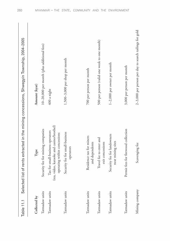
The militarisation that has accompanied the expansion of gold-mining ventures is not simply a means to provide security for these operations. The presence of large numbers of soldiers has also permitted the military to strengthen control over the local economy by extracting an array of rents, which are commonly defined as the extraction of uncompensated value from others. The predatory practices employed by tatmadaw battalions and their troops offer a case in point. Before the 2006 offensive, there were five battalions based in Shwegyin Township: Light Infantry Brigades Nos 589, 598, 349, 350 and Infantry Brigade No.57. Since each of these battalions has to extract rents to help cover operating costs and to make regular payments to their superior officers, the field units compete with one another while stationed temporarily in the concessions to extort additional resources from those who live or work in the extractive zones.23 (A similar system of ‘gates’—that is, military check-points where additional rents are extracted—is in place along the district’s roads and rivers but is not discussed here.) This competition also extends down to those units drawn from the same ‘mother’ battalion. Miners and farmers, for example, report that units rotate every month and demands for non-scheduled rents typically occur just before the soldiers return to their base, a practice that decreases the amount of money and food available to those who arrive to take their place. According to local sources, most of the illicitly gained income moves up the chain of command, first to Brigadier-General Thura Maung Nyi, who heads Division No.77, and then to Major-General Ko Ko, who is in charge of the Southern Regional Command based in Toungoo.24
The rents, although they generate fairly predictable revenue streams, are modest compared with the income generated by the gold itself. During
myanmar – the state, community and the environment��0
Tabl
e 11
.1
Sel
ecte
d lis
t of r
ents
ext
ract
ed in
the
min
ing
conc
essi
ons,
Shw
egyi
n To
wns
hip,
200
4–20
05
Col
lect
ed b
y T
ype
Am
ount
(ky
at)
Tatm
adaw
uni
ts
Secu
rity
fee
for
min
ing
com
pani
es
10–2
0,00
0 pe
r m
onth
(pl
us a
ddit
iona
l fee
s)
Tatm
adaw
uni
ts
Tax
for
smal
l-bu
sine
ss o
pera
tors
40
0 a
nigh
t
(t
ea, v
ideo
, kar
aoke
and
cas
ino/
brot
hel)
op
erat
ing
wit
hin
conc
essi
ons
Tatm
adaw
uni
ts
Secu
rity
fee
for
smal
l-bu
sine
ss
1,50
0–3,
000
per
shop
per
mon
th
oper
ator
s
Ta
tmad
aw u
nits
R
esid
ence
tax
for
min
ers
700
per
pers
on p
er m
onth
an
d de
pend
ents
Tatm
adaw
uni
ts
Trav
el fe
e to
ent
er a
nd
500
per
pers
on (
valid
one
wee
k to
one
mon
th)
exit
con
cess
ions
Tatm
adaw
uni
ts
Secu
rity
fee
for
land
owne
rs
1–2,
000
per
owne
r pe
r m
onth
ne
ar m
inin
g si
tes
Tatm
adaw
uni
ts
Perm
it fe
es fo
r fir
ewoo
d co
llect
ion
3,00
0 pe
r pe
rson
per
mon
th
Min
ing
com
pany
Sc
aven
ging
fee
2–
3,00
0 pe
r pe
rson
per
day
to s
earc
h ta
iling
s fo
r go
ld

spaces of extraction ���
Sour
ce: F
ield
Sur
vey
No.
001
(200
2); I
nter
view
Nos
001
–5 (
2005
), 0
01–2
FU (
2005
)
Hig
h-ra
nkin
g Le
ase
fee
for
min
ing
on p
riva
te p
rope
rty
Land
owne
r re
tain
s 60
per
cen
t of a
ll go
ld e
xtra
cted
m
ilita
ry
offic
ials
and
bu
sine
ssm
en
Tatm
adaw
bat
talio
ns
Tax
on m
iner
s em
ploy
ed b
y co
mpa
ny
1,00
0 pe
r m
iner
per
mon
th
Div
isio
n he
adqu
arte
rs
Con
cess
ion
fee
100,
000
per
mon
th
(sep
arat
e fr
om a
mou
nt p
aid
to
D
epar
tmen
t of M
ines
)
Div
isio
n he
adqu
arte
rs
Ren
tal f
ee fo
r hy
drau
lic
1–50
0,00
0 pe
r m
achi
ng p
er m
onth
(va
ries
acc
ordi
ng to
eq
uipm
ent (
goes
to ‘D
ivis
ion
Fund
’) pr
oduc
tivi
ty o
f sit
e)
Bri
gadi
er-G
ener
al
Perm
issi
on fe
e pa
id b
y 50
0,00
0 pe
r m
onth
T
hura
Mau
ng N
yi
batt
alio
ns to
col
lect
the
abov
e

myanmar – the state, community and the environment���
the early years of the gold-rush, high-ranking tatmadaw commanders, such as General Thura Maung Nyi, and local businessmen, such as Po Baing, reportedly purchased large tracts of land. Under current leasing arrangements, these men retain 60 per cent of all the gold extracted on properties they own. According to local sources, each of the mining concessions (which frequently has more than one hydraulic unit operating within it) produces an estimated 1.5kg of gold dust and flakes a month.25 While not a significant amount by international standards, the price of gold in Burma has nonetheless increased dramatically in the past several years, making it a highly lucrative source of income. In 2003, one kyat thar of gold (1.53 grams) sold for 90,000 kyats in Shwegyin Township (ERI and KESAN 2003:55).26 By April 2006, concerns about the stability of the regime and related inflationary pressures drove the price to a record high of 500,000 kyats per tical (16.3g), according to Xinhua (21 April 2006). At these rates, 1.5kg of gold a month would provide an astronomical return, especially when compared with the gross domestic product per capita in Burma, which is estimated to be a mere US$1,700 (CIA 2004).
These findings, which are summarised in Table 11.1, support a working hypothesis that the fee structure is not simply an extra-legal means to create wealth.27 The system, which fosters competition within and between different segments of the Tatmadaw, appears to establish a framework where ambitious officers, by strategically redistributing goods and services (including rights to collect rents), can advance their careers (see also KHRG 2001a). The arrangements also suggest that regulatory controls on the extractive industries are, at best, weak (see Gutter 2001). At worst, the staff members who work for the government departments representing different ministries are complicit in the abuses occurring around them. The Department of Mines, to offer one example, is charged with implementing the terms of the 1994 Myanmar Mines Law. Among other things, the law requires permit-holders to create safe conditions for workers; to use land and water in accordance with existing laws; and to pay royalties of between 4 and 5 per cent on all gold extracted (SLORC 1994). These and other requirements

spaces of extraction ���
specified under the law, however, appear never to have been enforced by the Department of Mines. In fact, local informants make no reference to the department in any of their accounts.
Conclusion
What accounts for or contributes to these forms of government along the waterways of Nyaunglebin District? In part, living conditions throughout much of the country have deteriorated to the point that, in order to feed themselves, many people now have to participate in practices that are morally corrosive and result in environmental degradation. One clear sign of this can be found in the concessions themselves. While some of the labourers working along the riverine networks are from the area, the majority of the miners are landless, economic migrants (ethnic Burmans, Shan and Chinese), who opt to perform the work despite the dangers involved and the fact that pay scales are rarely sufficient to meet daily expenses given high rates of local inflation. This emergent proletarian class, however, remains internally subdivided as all of the extractive industries exhibit a strong preference for hiring workers from their own ethnicity and men earn considerably more than women, even when they perform the same task. Additionally, Karen are employed only as a last resort, which leaves commercial charcoal production and the harvest of rattan and bamboo as the few ways subsistence farmers and internally displaced people can earn cash to purchase medicine, cooking oil and other necessities (ERI 2003). This is not to imply that people who live and work in the concessions lack agency; rather, it is to convey that for Burmans and non-Burmans alike, their scope for action, especially for anything beyond mere survival, has become sharply circumscribed in the past decade (Heppner 2005; Cusano 2001; TBBC 2005; Agamben 1998).
More generally, this case study has emphasised some of the key processes that make former conflict zones governable, namely: the militarisation of everyday life and the regulated violence that has accompanied it. The findings reveal that contradictory modes of

myanmar – the state, community and the environment���
government currently exist along the waterways of Nyaunglebin District, especially in Shwegyin Township, where mining concessions overlap those areas affected by the construction of the Kyaut Nagar Dam. The various actors involved—tatmadaw battalions, mining companies, construction companies and related state agencies—have devised quite different strategies and techniques for constituting their authority and for disciplining their labourers, even though they operate along the same short stretch of the Shwegyin River. Some of these actors have found ways to collaborate with each other, whereas other actors continue to work at cross purposes. Still other actors manage to do both simultaneously: the fierce competition for rents not only pits tatmadaw battalions against one another, but against their own soldiers, who seek to extract yet more resources from the mining companies and their labourers before rotating out of the mining concessions.
Such practices have simultaneously extended and fragmented the centralised state control of spaces where natural resources are located. This apparent contradiction is made possible by revenue flows that generate and sustain powerful patron–client networks that cross-cut the boundaries imagined to separate state from non-state institutions (see Nordstrom 2000, 2006; Roitman 1998). So while the military, administrative and economic reach of the regime is clearly growing stronger in Nyaunglebin District, the means by which its authority is exercised remains far from coherent or benign. The dam, as will be recalled, will displace the gold-mining companies, providing them with the opportunity to extend their operations towards Ku Shaw—a move that will likely lead to further armed conflict between the Tatmadaw and the KNU, as well as environmental degradation. Additionally, the dam will enable a massive commercial plantation east of the town of Shwegyin to be created. If this occurs, several thousand more farmers will lose their land and the district’s economy, once based on a diverse array of crops, will be replaced by a single, non-edible commodity: rubber. These cascading forms of displacement, which follow those that have already forced most of the Karen population that once lived along Nyaunglebin District’s waterways to leave (MacLean forthcoming), indicate that the transformation of Shwegyin Township is far from over.

spaces of extraction ���
Notes
1 For a discussion of the differences between ‘governance’ and ‘governmentality’, see Rose 1999:15–24. The emphasis here will be on governance.
2 Other important resources include timber, charcoal, bamboo and rattan.3 Interview Nos: 003 (2002), 002GM (2004), 001, 003, 002FU (2005). Unless
noted, all interviews were conducted by EarthRights International and are on file with the organisation. To protect informants’ identities, interviews as well as field documents and surveys are referred to by number rather than name.
4 Scott referred to such sites as potential ‘state spaces’, however, they are equally open to control by other (armed) groups, as is the case here.
5 The Democratic Karen Buddhist Army (DKBA), a splinter group allied with the SPDC, conducted itself similarly, but as of mid 2005 is no longer officially active in the district.
6 Field Survey No. 002 (2004).7 Interview Nos 001, 006 (2005).8 Field Document Nos 003, 006 (2005). 9 Field Document Nos 003, 006 (2005)10 Opinions remained divided on the broader significance of the 2006 offensive.
Some argue that the cease-fire still holds and that the operations were narrowly intended to create a larger buffer around the new capital in Naypyitaw, to punish anti-cease-fire factions within the KNU (especially Brigade No.2), and to secure access to natural resources in areas still patrolled by the KNLA. Others assert that the offensive is really a precursor to a much larger one intended to bring all of Nyaunglebin District and northern Karen State firmly under Rangoon’s control. Among other things, this would facilitate the completion of large hydroelectricity projects along the Salween River.
11 Interview Nos 005–6 (2005). 12 Interview No. 006 (2005). 13 Interview No. 006 (2005) 14 Interview Nos 002FU (2005), 003 (2005); Field Document No.009
(2005). 15 Field Document No. 002 (2004). 16 Interview No. 003 (2005).17 Field Survey No. 001 (2002); Interview No.002FU (2005).18 Interview Nos 001, 004 (2005).19 Interview Nos 002, 004 (2005).20 Field Document No.009 (2005); Interview No.118 (2004); ERI 2005:17–18.

myanmar – the state, community and the environment���
21 Interview Nos 003–5 (2005); Field Survey No. 004 (2005); TBBC 2004:67, 2005:80.
22 See also Interview Nos 001–2GM (2004), 002, 005 (2005); ERI and KESAN 2003:28–35; KESAN 2003:25, 28.
23 Field Survey No. 001 (2002); Interview Nos 001–5 (2005), 001–2FU (2005).
24 Interview No. 117 (2004). DKBA units have reportedly posed as tatmadaw troops in the past to collect fees from miners, which results in the same problem. Interview Nos 001–2FU (2005).
25 Local sources typically refer to the number of hydraulic mining machines operating in a general area, such as a stretch of river, instead of concessions per se. Between 20 and 30 hydraulic units have been operating along the Shwegyin River between the dam site and Kan Nee since 2003. Other sources, however, place the total closer to 50 machines. These figures do not include machines on other nearby tributaries, for example, the Mawtama River, where mining is similarly widespread, and parts of Kyauk Kyi Township, where at least 40 machines were operating in 2004. Interview Nos 117 (2004), 004, 007 (2005); Free Burma Rangers, email communication with author, 19 April 2006 and 13 May 2006.
26 Field Document No. 002 (2005).27 Field Survey No. 001 (2002); Interview Nos 001–5 (2005), 001–2FU
(2005).
References
Agamben, G., 1998. Homo Sacer: sovereign power and bare life, Stanford University Press, Stanford.
Anonymous, 2005. ‘Chairman of the State Peace and Development Council, Commander-in-Chief of Defence Services Senior General Than Shwe inspects Shwe Kyin Hydel power plant project’, The New Light of Myanmar, 12 March, as cited in Myanmar E-News Letter, 14 March:3.
——, 2006. ‘Myanmar seeks ways to cope with rising commodity prices’, Xinhua News Service, 30 March 2006, reprinted in Burma Net News, 30 March. Available from http://www.burmanet.org/news/2006/03/30/ (accessed 12 July 2006).
ASEAN India, 2005. Country Profile: Myanmar, opportunities in the electricity

spaces of extraction ���
sector. Available from http://www.aseanindia.net/asean/countryprofiles/myanmar/hydro-electric.htm (accessed 12 July 2005).
Asian Human Rights Commission, 1999. Voice of the Hungry Nation: the people’s tribunal on food scarcity and militarization in Burma, Asian Human Rights Commission, Hong Kong.
Bahro, R., 1978. The Alternative in Eastern Europe, Verso, London and New York.
Burma Border Consortium, 2003. Reclaiming the Right to Rice: food security and internal displacement in Eastern Burma, Burma Border Consortium, Bangkok. Available from http://www.ibiblio.org/obl/docs/BBC-Reclaiming_the_Right_to_Rice.pdf
Burma Ethnic Research Group and Friedrich Naumann Foundation, 1998. Forgotten Victims of a Hidden War: internally displaced Karen in Burma, April, Burma Ethnic Research Group, Chiang Mai. Available fromhttp://www.ibiblio.org/obl/docs3/Berg-Forgotten_Victims.pdf.
Central Intelligence Agency, 2004. The World Fact Book: Burma. Available from https://www.cia.gov/cia/publications/factbook/geos/bm.html (accessed 12 June 2006).
Cusano, C., 2001. ‘Burma: displaced Karens: like water on the khu leaf ’, in M. Vincent and B.R. Sorensen (eds), Caught Between Borders: response strategies of the internally displaced, Pluto Press, London:138–71.
EarthRights International and Karen Environmental and Social Action Network, 2003. Capitalizing on Conflict: logging and mining in Burma’s cease-fire zones, EarthRights International, Chiang Mai.
EarthRights International, 2005. ‘If We Don’t Have Time to Take Care of Our Fields the Rice Will Die’: a report on forced labor in Burma, EarthRights International, Chiang Mai. Available from http://www.earthrights.org/files/Reports/ILO_ForcedLaborReportinBurma2005.pdf.
——, 2007. Turning Treasures into Tears: mining, dams and deforestation in Shwegyin Township, Pegu Division, EarthRights International, Chiang Mai. Available from http://www.earthrights.org/files/Burma%20Project/report-_turning_treasure_into_tears.pdf.
Ferguson, J., 2006. ‘Governing extraction: new spatializations of order and disorder in neoliberal Africa’, in Global Shadows: Africa in the neoliberal world order, Duke University Press, Durham:194–210.
myanmar – the state, community and the environment���
Foucault, M., 1991. ‘Governmentality’, in G. Burchell, C. Gordon and P. Miller (eds), The Foucault Effect: studies in governmentality, Harvester Wheatsheaf, London: 87–104.
Frynas, J.G., 1998. ‘Political instability and business: focus on Shell in Nigeria’, Third World Quarterly, 19(3):457–78.
Global Witness, 2003. A Conflict of Interests: the uncertain future of Burma’s forests, Global Witness, London.
Gutter, P., 2001. ‘Environment and law in Burma’, Legal Issues on Burma 9:1–25.
Hardin, R., 2002. ‘Concessionary Politics in the Western Congo Basin: history and culture in forest use’, Environmental Governance in Africa Working Papers Series No. 6, November, World Resources Institute, Washington, DC. Available from: http://pdf.wri.org/eaa_wp6.pdf
Heppner, K., 2005. Sovereignty, Survival, and Resistance: contending perspectives on Karen internal displacement in Burma, Karen Human Rights Group, Kawthhoolei. Available from http://www.khrg.org/papers/wp2005w1.pdf (accessed 2 January 2006).
Houtman, G., 1999. Mental Culture in Burmese Crisis Politics: Aung San Suu Kyi and the National League for Democracy, Institute for the Study of Languages and Cultures of Asia and Africa, Tokyo University of Foreign Studies, Tokyo.
Inbaraj, S., 2004. ‘China covets Burmese resources’, The Irrawaddy, 27 July.
Images Asia and Pan Kachin Development Society, 2004. At What Price: gold mining in Kachin State, Burma, November, Nopburee Press, Chiang Mai. Available from http://www.ibiblio.org/obl/docs/gold%20pdf1.pdf.
International Crisis Group, 2001. Myanmar: the military regime’s view of the world, Asia Report No. 28, December, International Crisis Group, Bangkok.
International Labour Organization, 2006. Conclusions on Document GB.295/7: developments concerning the question of the observance by the government Myanmar of the forced labour convention, 1930 (No.29), International Labour Organization, Geneva.

spaces of extraction ���
Karen Environmental and Social Action Network, 2003. Thulei Kawwei [Karen Environmental Forum], Karen Environmental and Social Action Network, Chiang Mai.
Karen Human Rights Group, 2001a. Flight, Hunger, and Survival: repression and displacement in the villages of Papun and Nyaunglebin Districts, Karen Human Rights Group, Kawthoolei. Available from http://www.khrg.org/khrg2001/khrg0103a.html.
Karen Human Rights Group, 2001b. Abuse Under Orders: the SPDC and DKBA soldiers through the eyes of their soldiers, Karen Human Rights Group, Kawthoolei. Available from http://www.ibiblio.org/freeburma/humanrights/khrg/archive/khrg2001/khrg0101.pdf.
——, 2005. Proliferation of SPDC army camps in Nyaunglebin District leads to torture, killings and landmine casualties, 7 July 2005. Available from http://www.khrg.org/khrg2005/khrg05b5.html (accessed 22 August 2006).
Karen Rivers Watch, 2004. Damming at Gunpoint, Karen Rivers Watch, Kawthoolei.
MacLean, K. and Mahn Nay Myo, 2002. ‘Forced labor on the Shwegyin River in Burma’, World Rivers Review, 17(4):11.
MacLean, K., (forthcoming). ‘Communities in forced motion: concessions, state-effects, and regulated violence in Burma’, in N. Peluso and J. Nevins (eds), Taking Southeast Asia to Market: commodifications in a neoliberal age, Cornell University Press, Ithaca.
Nordstrom, C., 2000. ‘Shadows and sovereigns’, Theory, Culture, and Society, 17(4):35–54.
——, 2006. Global Outlaws: crime, money, and power in the contemporary world, University of California Press, Berkeley.
Ohmae, K., 1995. The End of the Nation-State: the rise of regional economies, Harper Collins, London.
Robinson, C.W., 2003. Risks and Rights: the causes, consequences, and challenges of development-induced displacement, Brookings Institute and CUNY Project on Internal Displacement, New York.
Roitman, J., 1998. ‘The Garrison-entrepôt’, Cahiers d’Etudes africaines, 38(150–2):297–329.

myanmar – the state, community and the environment��0
Rose, N. 1999. Powers of Freedom, Cambridge University Press, Cambridge.
Scott, J., 1998. ‘Freedom and freehold: space, people, and state simplification in Southeast Asia’, in D. Kelly and A. Reid (eds), Asian Freedoms: the idea of freedom in East and Southeast Asia, Cambridge University Press, Cambridge:37–64.
State Law and Order Restoration Council, 1994. The Myanmar Mines Law, 6 September 1994. Available from http://www.ibiblio.org/obl/docs3/Mining%20Law.htm (accessed 12 July 2006).
Thai Burma Border Consortium, 2004. Internal Displacement and Vulnerability in Eastern Burma, October, Thai Burma Border Consortium, Bangkok. Available from http://www.ibiblio.org/obl/docs/TBBC-IDPs2004-full.
——, 2005. Internal Displacement and Protection in Eastern Burma, October, Thai Burma Border Consortium, Bangkok. Available from http://www.ibiblio.org/obl/docs3/TBBC-Internal_Displacement_and_Protection_in_Eastern_Burma-2005.pdf.
——, 2006a. Internal Displacement in Eastern Burma: 2006 survey, Thai Burma Border Consortium, Bangkok. Available from http://www.ibiblio.org/obl/docs4/TBBC-2006-IDP-ocr.pdf.
——, 2006b. Internal Displacement in Eastern Burma: July 2006 update, Thai Burma Border Consortium. Available from http://www.tbbc.org/news/idp-update-06-07-28-page.html (accessed 22 August 2006).
Tse, P.K., 1991. ‘The mineral industry of Burma’, Minerals Yearbook: mineral industries of Asia and the Pacific, (3):60–9, US Bureau of Mines, Washington, DC.
Watts, M., 2004. ‘Resource curse? Governmentality, oil, and power in the Niger Delta, Nigeria’, Geopolitics, 9(1):50–80.
World Wildlife Fund, 2002. The Global 200. Available from http://www.nationalgeographic.com/wildworld/profiles/g200_index.html (accessed 14 July 2006).


![NAVIGABLE WATERS RULES ANNOTATED - IN.govUpdated February 14, 2011) 1 NAVIGABLE WATERS RULES ANNOTATED AND INDEXED [Document Index: pp. 46 – 50] _____ The navigable waters rules](https://static.fdocuments.in/doc/165x107/5ac47a757f8b9a5c558cd870/navigable-waters-rules-annotated-in-updated-february-14-2011-1-navigable-waters.jpg)