Sovereignty Submerged Lands Management in the … Submerged Lands Management in the State of Florida...
63
Sovereignty Submerged Lands Management in the State of Florida
Transcript of Sovereignty Submerged Lands Management in the … Submerged Lands Management in the State of Florida...

Sovereignty Submerged
Lands Management in the
State of Florida

What are Sovereign
Submerged Lands?
• Lands that Florida took ownership
to by virtue of its sovereignty upon
becoming a state in 1845.

• Through case law the definition has
evolved to include all lands to
which title has not been validly
conveyed that

• Lie below the ordinary high water line of navigable bodies of freshwater lakes, rivers and streams
• Lie below the mean high water line of tidally influenced bays, rivers and oceans
• Extend three miles into the Atlantic Ocean and three marine leagues (about 10.4 miles) into the Gulf of Mexico

A Short History of Sovereign
Submerged Lands

Origins of The Public Trust
Doctrine – The Bedrock of
Sovereignty Submerged
Lands Management

Origins…
• The Public Trust Doctrine dates back to the Sixth Century A.D.
• The Roman Emperor, Justinian, codified in his “Institutes” the idea that “by the law of nature these things are common to all mankind: the air, running water, the sea, and consequently the shores of the sea.”

Origins…
• After the Magna Carta, the Doctrine along with much of Roman Law was adopted into English Common Law
• The English kings considered tidelands and waters subject to commerce the “king’s highways” and part of the sovereign for the use of all the king’s subjects

Origins…
• As the kings of England granted
charters to the American colonies,
the Doctrine became a basic
element of American civil law
• The ability to use sovereignty lands
freely was imperative to the early
colonists not only for commerce but
for daily survival

Origins…
• Such uses included hunting,
fishing, bathing and washing
clothes; mooring boats; collecting
shellfish; cutting ice; watering
cattle; preparing flax; as passage
ways for pedestrians, horse back
riders and carriages
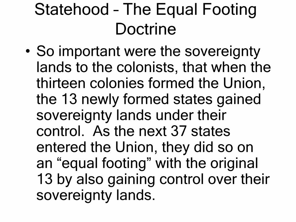
Statehood – The Equal Footing
Doctrine
• So important were the sovereignty lands to the colonists, that when the thirteen colonies formed the Union, the 13 newly formed states gained sovereignty lands under their control. As the next 37 states entered the Union, they did so on an “equal footing” with the original 13 by also gaining control over their sovereignty lands.
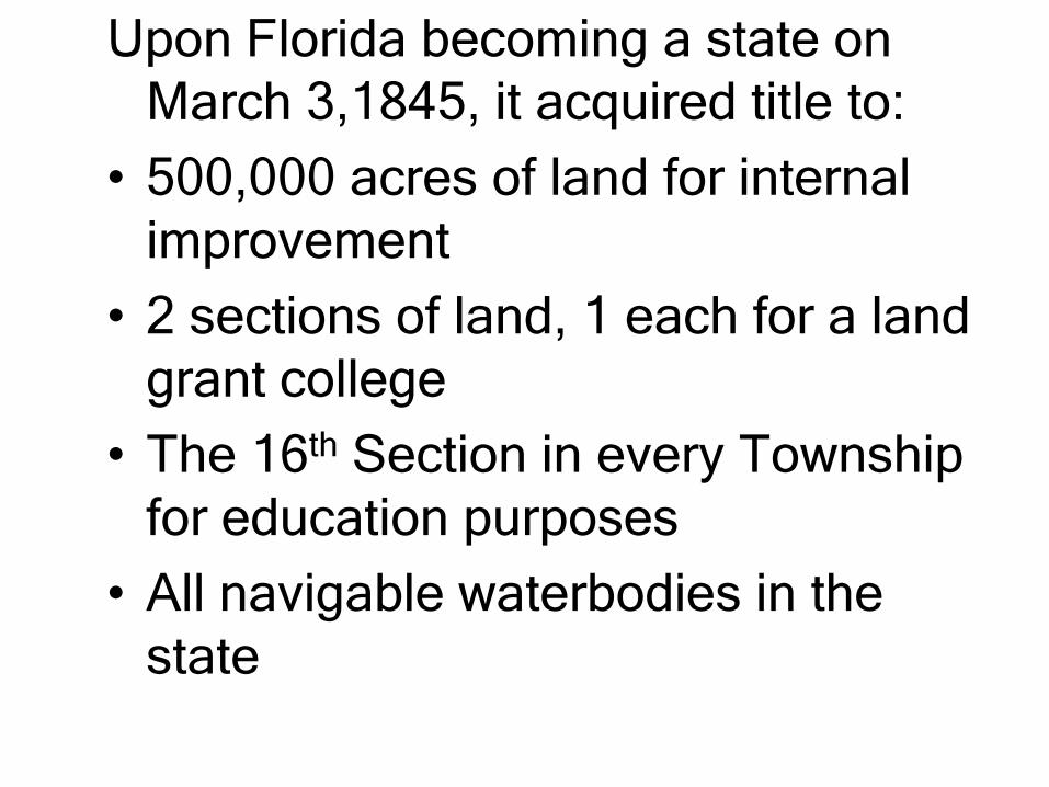
Upon Florida becoming a state on
March 3,1845, it acquired title to:
• 500,000 acres of land for internal
improvement
• 2 sections of land, 1 each for a land
grant college
• The 16th Section in every Township
for education purposes
• All navigable waterbodies in the
state

1850 – U.S. Swamp Lands Act
• Purpose was for the feds to identify
for conveyance to each state lands
that were unfit for cultivation
because of their swampy character
and to improve and reclaim them
“by means of levees and drains.”
• More than 20,000,000 acres out of
a total of 36,000,000 acres (the size
of Florida not including submerged
lands) were ultimately conveyed to
the State of Florida.

U.S. Swamp Lands Act of 1850…
• On the condition that these lands be reclaimed, most were sold in large tracts to private railroad companies and other developers such as the 4,000,000 acres to Hamilton Disston of Philadelphia for $1 million. The Disston tract stretches from Pasco County to Collier County.

Public Lands Survey System
• Devised by Thomas Jefferson to be a consistent method for subdividing land into grids of sections, townships and ranges
• Became the basis for future public and private land surveys
• From 1819 to the 1880s surveyors under the direction of the U.S. General Land Office conducted surveys throughout the State

• Generally conducted during the dry
season
• Some surveyors were thorough and
competent while others it is evident
from their work may have simply
connected the dots from the
comfort of their tent

• Survey lines were run mostly along
section lines with notations made in
the field books when a stream or
other waterbody was crossed, e.g.
“3 chains wide, 2 feet deep at
center” or differentiation was made
between swamp land and fast land

• Many navigable waterbodies and
just about all tide lands were
identified as sovereign by
meandering which is a traverse run
along the perimeter of a water body

• Some fairly large waterbodies were not meandered because they were located on the interior of a section or in an area noted as “Impracticable Swamp” in the field notes
• Lake Surprise, north of Key Largo, thus aptly named, was one of those waterbodies

1855 – Establishment of the
Board of Trustees
• By act of the legislature the governor and four other state officers were vested with the authority in trust to oversee the sale of the remainder of the 500,000 acres that came to the state in 1845 and the 20,000,000 acres reserved for swamp and overflow grants

• Proceeds from the sales were to go
into a distinct and separate fund
called the Internal Improvement
Trust Fund
• The act also gave the Trustees the
authority to dispose of lands
underneath navigable waterbodies
and tide lands.

Come on Down!
• For the next 115 years Florida’s public trust lands were sold to encourage people to settle in Florida and reclaim uninhabitable swamp lands by dredging and filling them
• No one questioned during this era that development was the best way to serve the public trust

1962 – Publication of Rachel
Carson’s “The Silent Spring”
• Dawn of the modern environmental
movement
• There is a web of life that we must
protect or risk irreparable harm to the
living world
• Beginning of awareness that no longer
would the public interest best be served
by the sale of sovereign lands to
promote development

• The public interest test from hereon
would best be served by balancing
economics with the preservation of
the public’s sovereign lands so that
its resources would be healthy and
in abundance for future generations
to use and enjoy

1968-69
• A moratorium was placed on the
filling of sovereign submerged
lands due to the increasing
awareness of the impacts to the
entire food chain caused by filling in
of marine habitat
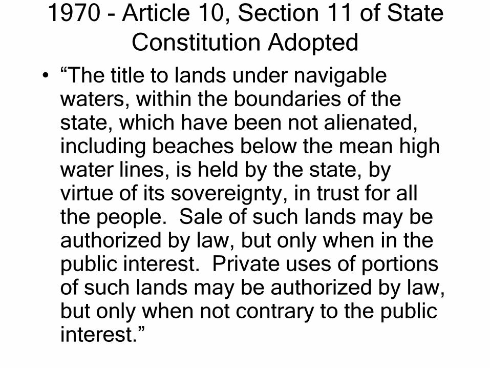
1970 - Article 10, Section 11 of State
Constitution Adopted
• “The title to lands under navigable waters, within the boundaries of the state, which have been not alienated, including beaches below the mean high water lines, is held by the state, by virtue of its sovereignty, in trust for all the people. Sale of such lands may be authorized by law, but only when in the public interest. Private uses of portions of such lands may be authorized by law, but only when not contrary to the public interest.”

1970…
• Sales of sovereign submerged lands or authorization to fill them have been extremely rare since 1970
• Generally, only public entities have been granted authorization to fill sovereign lands and only when the proposed projects will benefit the public at large

1970…
• First Licenses Required for
Commercial Marinas
• Rate per square foot of preempted
area caused by the docks and
associated mooring areas was a
whopping 2 cents

1974 – Coastal Mapping Act
• Established a methodology for
surveying the mean high water line
along tidally influenced waterbodies
based on the mean of the high tides
over a nineteen year lunar cycle
• There is still no statutorily approved
methodology for locating the
ordinary high water line

1975 – Creation of DNR and DER
• A chapter in the 120 year history of the Board of Trustees ended when staff in the Board of Trustees’ agency (about 105 employees) were transferred to the newly created Department of Natural Resources, Bureau of State Lands Management (later to become the Division of State Lands).

1978
• Rule 16-21 of the Florida Administrative
Code went into effect – it provided the
beginning framework for sovereign
lands management
• Sovereignty submerged lands leases
were required for commercial marinas –
still 2 cents per square foot – those with
licenses converted to leases when up
for renewal

1982
• Under the amended rules of 18-21, F.A.C., leases are required for larger multi-family docking facilities (condominiums and single-family residential common area docking facilities)

1983
• Grandfather I Program begins –
Required commercial docking
facilities built prior to March 10,
1970 and larger multi-family
docking facilities built prior to March
27, 1982 to register as
grandfathered structures prior to
September 30, 1984
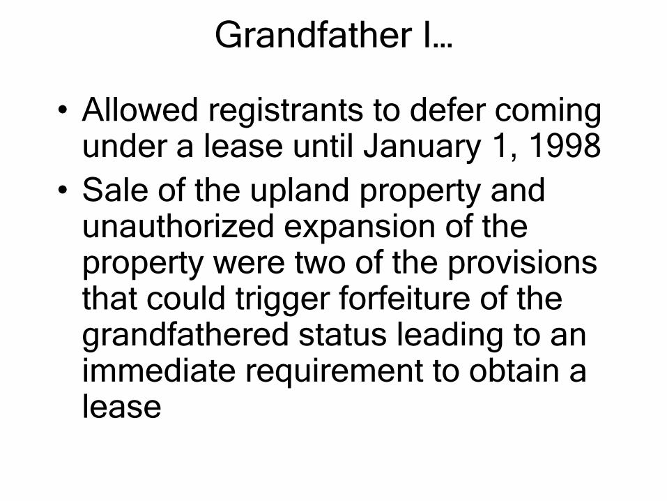
Grandfather I…
• Allowed registrants to defer coming under a lease until January 1, 1998
• Sale of the upland property and unauthorized expansion of the property were two of the provisions that could trigger forfeiture of the grandfathered status leading to an immediate requirement to obtain a lease

1990 – Grandfather II Begins
• Due to complaints from many waterfront property owners that Grandfather I was not sufficiently publicized, a second grandfather program was established to allow those who would have qualified under Grandfather I to register by April 1, 1991, avoid lease fees in arrears, but enter a lease effective April 1, 1991.

1993
• Merger of DER and DNR mainly to
streamline permitting
• Consolidated reviews of
applications for wetlands permitting
and authorizations to use sovereign
submerged lands
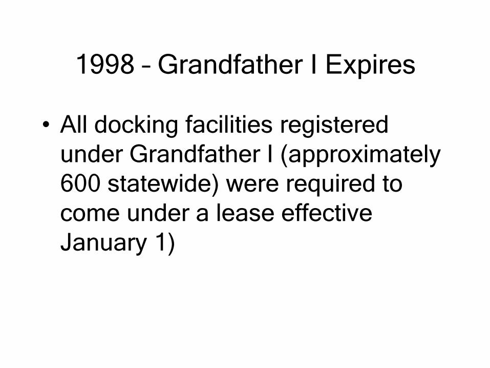
1998 – Grandfather I Expires
• All docking facilities registered
under Grandfather I (approximately
600 statewide) were required to
come under a lease effective
January 1)

Forms of Authorization – See Section
18-21.005, F.A.C.
• Chapter 253.77 requires that
authorization be obtained for any
construction or activity proposed on
sovereignty submerged lands
• With a few exceptions applicant
must be the riparian upland owner
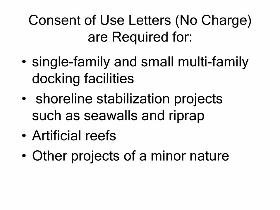
Consent of Use Letters (No Charge)
are Required for:
• single-family and small multi-family
docking facilities
• shoreline stabilization projects
such as seawalls and riprap
• Artificial reefs
• Other projects of a minor nature

Leases Granting Exclusive Use are
Required for:
• All commercial docking facilities
including marinas and docks used as an
accessory to an upland revenue
generating activity,e.g. a restaurant
• larger multi-family docking facilities
outside an aquatic preserve
• Multi-family docking facilities having
more than two slips in an aquatic
preserve

Leases…
• Current rate per square foot is
about $0.15 per year
• Most lease terms extend for 5 or 10
years
• Renewable if in compliance with
the terms of the lease

Easements (Public or Private) are
Required for:
• Utility crossings
• Bridges and roads
• New channels
• Borrow areas

So, You Always
Wanted Your Own
Marina!

First Step in Application
Process
• Before the Department begins
conducting a review of the application,
the DEP Title and Land Records
Section must determine whether the
submerged lands underneath the
proposed marina are state-owned

What are not Sovereign Lands
• Those previously conveyed by
Trustees’ Deed or legislative grant
• Privately owned uplands that were
excavated to create submerged
lands
• Non-tidal lands that are not
navigable

Examples of Trustees’ Deeds
• Trustees’ Deed for submerged lands of Boca Ciega Bay purchased by Mr. Connolly as a tax deed
• Tierra Verde was created by dredge and fill pursuant to conveyance of a Trustees Deed
• Some Trustees’ deeds were conveyed back to the state – the Brighwater Drive area in Clearwater Beach

DEP Application Review
Criteria
• Current and Proposed Upland Uses
• Current and Proposed Submerged Land
Uses
• Density of Submerged Land Use in the
vicinity if located in an aquatic preserve

Review Criteria…
• Navigation related data such as water
depths, width of affected waterbody,
proximity of inlets and proximity to
navigation channels
• Location and densities of benthic
resources such as sea grasses, oysters,
etc.
• Ambient water depths for mooring,
ingress and egress

Review Criteria…
• Size, types and drafts of boats anticipated
• Affect on adjoining property owners riparian rights (25 foot setback requirement)
• Comments or objections from property owners within a 500 foot radius of the proposed lease area
Review Criteria…
• Special management area designations such as aquatic preserve, manatee sanctuary, approved shellfish harvesting waters
• Comments from other agencies having purview – Florida Fish and Wildlife Conservation Commission, U.S. Fish and Wildlife, Department of Community Affairs, local government (comp plan consistency), etc.
Approval or Denial?
• Project modifications may be necessary
based on an analysis of whether the
project meets the aforementioned
review criteria
• Examples of modifications to make a
project approvable are:
Modifications…
• Reduction in preempted area or number of slips (usually in an environmentally sensitive area)
• Elimination of mooring in areas having resources or insufficient water depths or conversion of a proposed docking structure to a fishing pier
• Elevation of docks to allow more sunlight
• Relocation of dock or mooring piling to meet 25-foot setback requirement

Who Has Final Say?
• DEP District Director approves or
denies application for facilities having
less than 50 slips or 50,000 square feet
• Board of Trustees approves or denies if
over above thresholds or if project has
or is expected to elicit heightened
public concern
If Denied?
• Applicant has option of pursuing an
administrative appeal through the
Division of Administrative Hearings in
accordance with Chapter 120, Florida
Statutes

Some Common Misconceptions
• Meander lines are boundaries between private and state land
• Spanish land grants, U.S. Patents, swamp and overflowed deeds and Murphy Act tax deeds conveyed sovereignty submerged lands
• Riparian rights provide a proprietary interest in the submerged lands

Some Common Misconceptions…
• “Submerged lands located between
waterfront property and an offshore
bulkhead line are mine”
• “I’ve been paying taxes on this land
for years”

Conclusions

The Public Trust Doctrine Today
• obligates the states to act as
trustees of all public lands and
waters to ensure that the uses of
those lands are at the least not
contrary to the public interest
• has been expanded to include the
protection of living resources on
sovereignty lands

Conclusions…
• The management of sovereign lands is a balancing act between the rights of waterfront property owners to gain ingress and egress to navigable water by construction of a dock and the public’s entitlement to use to the greatest extent possible their lands for the traditional uses of commerce, fishing, swimming and other kinds of recreation

Conclusions…
• The rules are set to manage sovereign
submerged lands so as to give consent
for minimal or reasonable use at no
charge and charge compensation for
preemption that is more intensive or
when the use will result in profit gained

When to Think DEP
• If you wish to construct on sovereign
submerged lands, wetlands or any
surface waters, you should inquire at
the DEP Southwest District Office
regarding whether a permit and/or
sovereign lands authorization is
required (Phone (813) 744-6100)

When to Think DEP…
• To obtain a determination whether
an existing or proposed structure or
activity is located on sovereignty
lands, contact the DEP Title and
Land Records Section at (850) 245-
2788

When to Think DEP…
• For information regarding
sovereignty lands issues, feel free
to contact Harry Michaels at (813)
744-6100, extension 337.