Southwest Planning Area
12
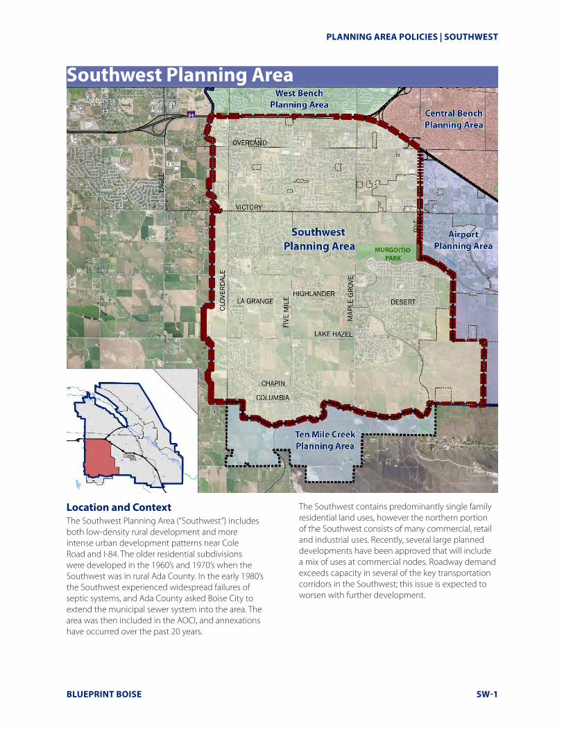
PLANNING AREA POLICIES | SOUTHWEST BLUEPRINT BOISE SW-1 Southwest Planning Area Location and Context The Southwest Planning Area (“Southwest”) includes both low-density rural development and more intense urban development patterns near Cole Road and I-84. The older residential subdivisions were developed in the 1960’s and 1970’s when the Southwest was in rural Ada County. In the early 1980’s the Southwest experienced widespread failures of septic systems, and Ada County asked Boise City to extend the municipal sewer system into the area. The area was then included in the AOCI, and annexations have occurred over the past 20 years. The Southwest contains predominantly single family residential land uses, however the northern portion of the Southwest consists of many commercial, retail and industrial uses. Recently, several large planned developments have been approved that will include a mix of uses at commercial nodes. Roadway demand exceeds capacity in several of the key transportation corridors in the Southwest; this issue is expected to worsen with further development.
-
Upload
hoangtuyen -
Category
Documents
-
view
219 -
download
0
Transcript of Southwest Planning Area
PLANNING AREA POLICIES | SOUTHWEST
BLUEPRINT BOISE SW-1
Southwest Planning Area
Location and ContextThe Southwest Planning Area (“Southwest”) includes both low-density rural development and more intense urban development patterns near Cole Road and I-84. The older residential subdivisions were developed in the 1960’s and 1970’s when the Southwest was in rural Ada County. In the early 1980’s the Southwest experienced widespread failures of septic systems, and Ada County asked Boise City to extend the municipal sewer system into the area. The area was then included in the AOCI, and annexations have occurred over the past 20 years.
The Southwest contains predominantly single family residential land uses, however the northern portion of the Southwest consists of many commercial, retail and industrial uses. Recently, several large planned developments have been approved that will include a mix of uses at commercial nodes. Roadway demand exceeds capacity in several of the key transportation corridors in the Southwest; this issue is expected to worsen with further development.
SW-2 BLUEPRINT BOISE
SOUTHWEST | PLANNING AREA POLICIES
Demographic Profile
PopulationPopulation: In 2010 the population of the Southwest was 38,130, 13.5% of the city total.
Median Age: Southwest residents are older (36.5 years) than Boise residents as a whole.
Housing Total Households: In 2010, the Southwest was home to 113,764 households. This accounts for 11.6 percent of the households in Boise.
Household Composition: More families with children reside in the Southwest, with 29.5 percent of residents falling under the age of 20.
Median Home Value: Median home value in the Southwest ($212,395) is 9.2 percent higher than in Boise as a whole.
Tenancy: Most Southwest residents own their homes (85.6 %). Southwest renters represent just 10.8 percent of all households.
IncomeMedian Household Income: Median Household Income: In 2009, median household income for Southwest residents was $75,223.
EmploymentJobs: There were 11,369 jobs in the Southwest in 2007 comprising 7.5 percent of Boise jobs.
Workforce: Southwest workers represent 14.0 percent of the Boise workforce.
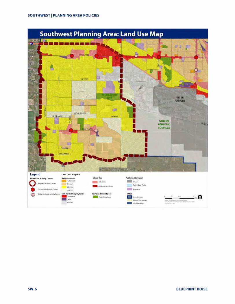
Land Use Characteristics
Existing Land Use
� The Southwest is the fourth-largest planning area. It contains 7,166 acres—just over 16 percent of Boise’s total acres.
� The Southwest has the most acres in single family residential use (4,846 acres), occupying 67.6 percent of the Southwest.
� Agriculture/grazing uses occupy 11 percent (835 acres) of the Southwest.
� Commercial (267 acres) and industrial (73 acres) uses represent a small percent of the Southwest, but comprise 11.7 and 6 percent, respectively, of all such acres in Boise.
� Other land uses include airport (267 acres), public/semi-public (264 acres), and parks, recreation and open space (258 acres); each occupying nearly 4 percent of the Southwest.
TRENDS AND KEY ISSUES Employment
� There are more workers living in the Southwest than there are jobs located in the Southwest.
Land Composition
� The Southwest contains a wide variety of land uses including: single family residential, commercial and industrial, and agriculture/grazing uses., however a lack of transit exists in the area. It is the City’s intention to focus development in designated activity centers particularly in disinvested areas.
Parks and Recreation
� Peppermint Park features many amenities including turf areas, trees, open space, and walking paths. The park was funded through the use of neighborhood impact fees.
Annexation in the Southwest
The Boise City Sewer Extension Policy reads in part;
For any development, prior to granting final sewer construction plan approval, the City will require the following:
Within the Area of Impact-A recommendation of approval by Boise City Council and confirmation of the County adopting the Boise City Council’s recommended conditions of approval for any development.
All new subdivisions in the Southwest are required to include a plat note requesting annexation to Boise City.
BLUEPRINT BOISE SW-3
PLANNING AREA POLICIES | SOUTHWEST
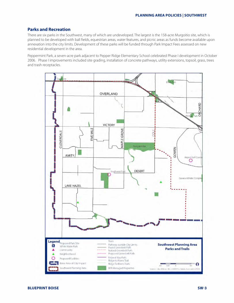
Parks and Recreation There are six parks in the Southwest, many of which are undeveloped. The largest is the 158-acre Murgoitio site, which is planned to be developed with ball fields, equestrian areas, water features, and picnic areas as funds become available upon annexation into the city limits. Development of these parks will be funded through Park Impact Fees assessed on new residential development in the area.
Peppermint Park, a seven-acre park adjacent to Pepper Ridge Elementary School celebrated Phase I development in October 2006. Phase I improvements included site grading, installation of concrete pathways, utility extensions, topsoil, grass, trees and trash receptacles.
SW-4 BLUEPRINT BOISE
SOUTHWEST | PLANNING AREA POLICIES
SchoolsThere are ten schools located in the Southwest:.
High Schools
� Frank Church High School is an alternative high school that began classes in 2008. The purpose of the Frank Church High School is to assist students who have dropped out or are at risk of dropping out of traditional school in graduating from high school.
Junior High Schools
� West Junior High School was constructed in 1952-53 at the intersection of Curtis Road and Emerald Road and had several additions throughout the years in an effort accommodate expanding enrollment numbers. In the fall of 2008, West moved from the location at Curtis and Emerald to its new location behind the district offices off of Victory Road and has an enrollment of 783 students.
� Lake Hazel Middle School is located at the intersection of LaGrange and Valley and has 1035 students in attendance.
Elementary Schools
� Pepper Ridge Elementary School is located near the intersection of Cloverdale and Overland roads. Pepper Ridge elementary school was opened in the fall of 2004, adjacent to Peppermint Park and has a total enrollment of 638 students.
� Maple Grove Elementary School is located just north of Victory on Maple Grove Road. The original Maple Grove Schoolhouse sat on the southeast corner of Franklin and Maple Grove Roads and was abandoned by the District in the late 1940’s. In 1968 the new Maple Grove School was constructed and was planned for twelve classrooms but the area grew so rapidly that seven more classrooms were added. In 1973 an additional six classrooms were added. The school has a total enrollment of 560.
� Amity Elementary School opened in 1979 as a model for school construction nationwide because of the use of solar energy and earth cover. The school’s design won several awards for its energy saving, efficient design. 673 students attend Amity Elementary and it is located on Amity Road between South Five Mile Road and Cloverdale Road.
� Silver Sage Elementary School is located on West Snohomish Street west of Cole Road. Silver Sage is a neighborhood school that is committed to academic growth for each of its 325 students.
� Lake Hazel Elementary School is located on Lake Hazel Road east of Cloverdale Road. Lake Hazel Elementary School was built in 1974 and is located within the Meridian School District boundaries and has an enrollment of 464 students.
� Desert Sage Elementary School is located within the Charter Pointe Community south of Lake Hazel Road. It opened at the beginning of the 2006-2007 school year. This school has a capacity of 650 students and has 711 students enrolled at this time.
� Christine Donnell School of Arts is the first magnet school and first art-based elementary school in the State of Idaho. It is located on Five Mile Road, south of Lake Hazel Road. Starting in 2004, 364 students from five traditional elementary schools chose to attend the school. Today the school is home to 462 students in grades K through 8 and the student body is selected by lottery rather than by any admission criteria.
TRENDS AND KEY ISSUES Schools
� There are ten schools located in the Southwest. Elementary schools include: Pepper Ridge, Maple Grove, Amity, Silver Sage, Lake Hazel, Silver Sage, and Christine Donnell School of the Arts.
� The two junior high schools located in the Southwest are Lake Hazel and West Junior High schools.
� Frank Church is the only high school located in the Southwest.
BLUEPRINT BOISE SW-5
PLANNING AREA POLICIES | SOUTHWEST
Sources:COMPASS Community Choice Growth Projections, August 2007.2010 Census Data for Population and Households.COMPASS Development Monitoring Reports (2000-2007).ESRI Business Analyst Report, Southwest Planning Area (2009).
SOUTHWEST | PLANNING AREA POLICIES
SW-6 BLUEPRINT BOISE
PLANNING AREA POLICIES | SOUTHWEST
BLUEPRINT BOISE SW-7
SOUTHWEST POLICIES
Centers, Corridors, and Neighborhoods (SW-CCN)Goals and policies for this section focus on promoting the revitalization of major travel corridors and activity centers; ensuring the scale of development is compatible with the Southwest’s varied character; and identifying areas where more detailed planning will be needed in the future.
Goal SW-CCN 1: Promote a diverse land use pattern that increases opportunities for housing and community and neighborhood services while retaining the distinctive rural elements of the Southwest.
SW-CCN 1.1: DESIGNATED ACTIVITY CENTERSFive mixed-use activity centers have been designated to serve the Southwest. They include:
� Overland and Five Mile;
� Victory and Five Mile;
� Lake Hazel and Five Mile;
� Lake Hazel and Maple Grove; and
� I-84 and Overland.
Additional activity centers may be designated in accordance with the location criteria provided in Chapter 5.
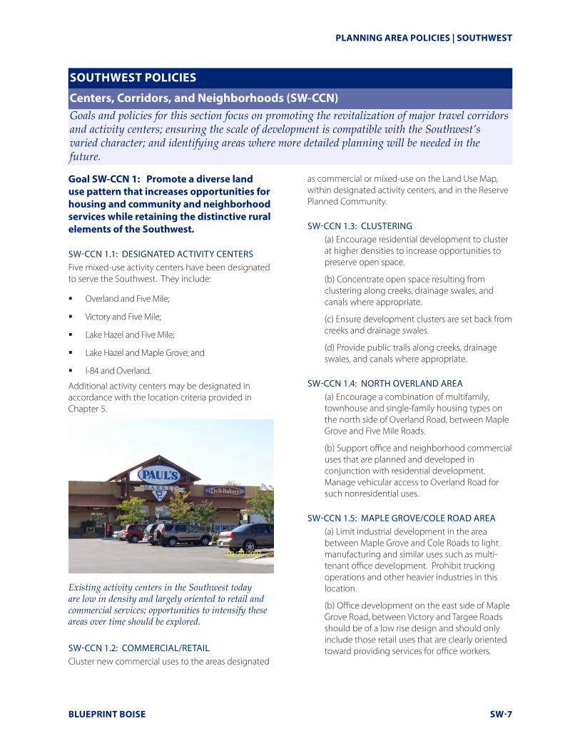
Existing activity centers in the Southwest today are low in density and largely oriented to retail and commercial services; opportunities to intensify these areas over time should be explored.
SW-CCN 1.2: COMMERCIAL/RETAILCluster new commercial uses to the areas designated
as commercial or mixed-use on the Land Use Map, within designated activity centers, and in the Reserve Planned Community.
SW-CCN 1.3: CLUSTERING(a) Encourage residential development to cluster at higher densities to increase opportunities to preserve open space.
(b) Concentrate open space resulting from clustering along creeks, drainage swales, and canals where appropriate.
(c) Ensure development clusters are set back from creeks and drainage swales.
(d) Provide public trails along creeks, drainage swales, and canals where appropriate.
SW-CCN 1.4: NORTH OVERLAND AREA(a) Encourage a combination of multifamily, townhouse and single-family housing types on the north side of Overland Road, between Maple Grove and Five Mile Roads.
(b) Support office and neighborhood commercial uses that are planned and developed in conjunction with residential development. Manage vehicular access to Overland Road for such nonresidential uses.
SW-CCN 1.5: MAPLE GROVE/COLE ROAD AREA(a) Limit industrial development in the area between Maple Grove and Cole Roads to light manufacturing and similar uses such as multi-tenant office development. Prohibit trucking operations and other heavier industries in this location.
(b) Office development on the east side of Maple Grove Road, between Victory and Targee Roads should be of a low rise design and should only include those retail uses that are clearly oriented toward providing services for office workers.
SOUTHWEST | PLANNING AREA POLICIES
SW-8 BLUEPRINT BOISE
SW-CCN 1.6: AMITY ROAD AREA Cluster development in the area generally bounded by Amity, Maple Grove, Five Mile and Lake Hazel Roads, to preserve open space and provide setbacks from the Five Mile and Eight Mile Creeks.
SW-CCN 1.7: NEIGHBORHOOD ACTIVITY CENTER Establish a neighborhood activity center in the vicinity of Lake Hazel and Five Mile Roads. Mixed residential commercial, townhouses and modular-lot residential uses should be permitted in and around the urban village. Densities as high as 15 to 20 units per acre may be permitted in the village, but should transition to four units per gross acre abutting existing low-density residential areas.
SW-CCN 1.8: ANNEXATION INFORMATION Provide property owners and residents with information on city zoning and other regulations upon annexation.
SW-CCN 1.9: OVERLAND ROAD AND FIVE MILE ROAD CORRIDORS Encourage a more pedestrian-oriented development pattern along Overland and Five Mile Roads.
SW-CCN 1.1O: AIRPORT INFLUENCEEnsure all development within the Airport Influence Area complies with noise standards for development as outlined in Chapter 3 of this Comprehensive Plan.
Goal SW-CCN 2: Support a pattern of coordinated development within the Reserve Planned Community Area.
SW-CCN 2.1: CONCEPTUAL MASTER PLANA conceptual master plan that demonstrates adherence to these principles should be submitted to the Planning and Zoning Commission for approval prior to the first entitlement in The Reserve area.
SW-CCN 2.2: BOUNDARYDefine the Reserve Planned Community Area as an area generally bounded by the New York Canal and Cole Road on the west, Pleasant Valley on the east, and the extension of South Latigo Roads on the south.
SW-CCN 2.3: MIX OF USES(a) Establish the Reserve as a mixed-use development with a range of residential housing types and densities, neighborhood commercial centers, and a business campus.
(b) Appropriate locations for each use type are outlined in the policies below.
SW-CCN 2.4: BUSINESS CAMPUS(a) Establish a business campus north of Lake Hazel Road extension that includes a mix of uses such as assembly, auto repair and service, fabrication, medical and dental laboratories and research facilities, wholesale, offices, self service storage and medical and professional offices.
(b) Incorporate ancillary uses such as restaurants, health clubs, and child care and convenience centers within the business campus provided they are intended to primarily serve employees of the business park and the surrounding residential community.
(c) Regional serving commercial uses should not be allowed.
SW-CCN 2.5: LAKE HAZEL ROAD EXTENSION (AREA TO NORTH)Apply the following considerations to the area north of the Lake Hazel Road extension:
(a) Provide safe access for school children to walk from the area north of Lake Hazel Road to a planned school located on the south side of the Lake Hazel Road extension.
SW-CCN 2.6: LAKE HAZEL ROAD EXTENSION (AREA TO SOUTH)Apply the following considerations to commercial development in the area south of the Lake Hazel Road extension:
(a) Establish two small pedestrian-oriented neighborhood commercial centers.
(b) Develop neighborhood commercial centers and surrounding residential development as an urban village, utilizing New Urbanism principles to integrate the commercial center with the residential community and create a community gathering place.
PLANNING AREA POLICIES | SOUTHWEST
BLUEPRINT BOISE SW-9
(c) Design buildings with a pedestrian scale and site them in proximity to the street frontage to convey a visual relationship to the street and provide for easy pedestrian access.
(d) Provide connections between buildings and adjacent residential areas using common sidewalks, pedestrian areas, bicycle routes and secondary streets.
Apply the following considerations to residential development in the area south of the Lake Hazel Road extension:
(a) Incorporate a variety of residential housing types, densities, and price points, including: townhouses, row houses, multi-family or condominiums, small lot patio homes, accessory dwellings, live/work, and detached single family dwellings. Allow for live/work units and accessory dwelling units.
(b) Encourage a mix of residential/commercial, live/work units, townhouses, condominiums, and/or multi-family along the south side of the Lake Hazel Road extension at a density of 10-20 units per acre.
(c) Locate residential housing types such as townhouses, multi-family, and small lot patio or row homes around the school/park at densities ranging from 6-15 dwelling units per acre.
(d) Include equestrian trails in the southernmost area where the density can drop to one to five units per acre.
(e) Limit the overall developed density for the area south of the Lake Hazel Road extension to six dwelling units per gross acre.
(f ) Connect residential areas using a system of pedestrian pathways, bike paths and interconnected streets.
SW-CCN 2.7: PEDESTRIAN CONNECTIVITYEncourage pedestrian activity through the use of detached sidewalks, reasonable block lengths and micro-paths. Discourage use of cul-de-sacs.
SW-CCN 2.8: OPEN SPACE AND PATHWAY SYSTEM(a) Establish an open space and pathway system adjacent to the New York Canal and Eight Mile Creek. Dedicate these pathways to the City of Boise, if acceptable to the Parks and Recreation Department.
(b) Encourage dual purpose drainage areas that provide usable open space and/or amenities.
SW-CCN 2.9: ELEMENTARY SCHOOL/CITY PARK(a) Establish a site for the co-location of an elementary school and a new City Park south of the Lake Hazel extension, centered in the residential neighborhood on local, not collector, streets.
(b) Provide street frontage on a minimum of two sides of the park.
(c) Connect the park/school site to the pathway adjacent to the New York Canal.
(d) Dedicate this pathway to the City of Boise, if acceptable to the Parks and Recreation Department.
SW-CCN 2.10: AIRPORT INFLUENCE AREASDevelopment in the Reserve Planned Community area must adhere to the land-use restrictions of the Airport Influence Areas.
SW-CCN 2.11: STREET NETWORK AND CAPACITY(a) Development adjacent to the Lake Hazel Road extension should include a back road system for vehicular access to limit access to the Lake Hazel Road extension.
(b) Support the densities and intensities of use outlined in these policies contingent upon satisfactory street capacity as determined by future traffic analysis.
SOUTHWEST | PLANNING AREA POLICIES
SW-10 BLUEPRINT BOISE
SOUTHWEST POLICIES
Connectivity (SW-C)Goals and policies for connectivity focus on identifying and implementing improvements that will enhance the ease and safety of multi-modal travel in the Southwest.
Goal SW-C1: Improve pedestrian and bicycle safety and linkages.
SW-C 1.1: LAKE HAZEL CONNECTIONExtend Lake Hazel Road eastward as shown on the Lake Hazel/Gowen Relocation Alignment Study Report.
SW-C 1.2: INTERCONNECTED STREETSParticular attention should be paid to new development to ensure compatibility with existing development including street system interconnections.
SW-C 1.3: PEDESTRIAN CROSSINGSImprove pedestrian-connections across Five Mile Road and Lake Hazel Road.
SW-C 1.4: PEDESTRIAN TRAILS(a) Expand the network of trails along canals and other open space corridors to connect neighborhoods, parks, and schools.
(b) Encourage development to provide micropath connections to surrounding trails and roadways.
GOAL SW-C2: Improve street system connectivity.
SW-C 2.1: COLLECTOR ROADS Develop new collector roads in accordance with the Master Streets map.
SW-C 2.2: RESUBDIVISIONS & STREET CONNECTIONSResubdivisions of existing large lots will provide new street connections as needed to improve connectivity throughout the Southwest
PLANNING AREA POLICIES | SOUTHWEST
BLUEPRINT BOISE SW-11
SOUTHWEST POLICIES
Public Services/Facilities (SW-PSF)Goals and policies for this section focus on identifying areas where investment in infrastructure are needed in the Southwest to implement the community’s vision.
Goal SW-PSF 1: Ensure public services and facilities are available upon annexation.
SW-PSF 1.1: FIRE STATION SITING Implement the fire station siting plan in coordination with the Boise Fire Department.
SW-PSF 1.2: SEWER EXPANSIONThe Boise City Sewer Extension Policy reads in part;
For any development, prior to granting final sewer construction plan approval, the City will require the following:
Within the Area of Impact-A recommendation of approval by Boise City Council and confirmation of the County adopting the Boise City Council’s recommended conditions of approval for any development.
All new subdivisions in the Southwest are required to include a plat note requesting annexation to Boise City.
SOUTHWEST | PLANNING AREA POLICIES
SW-12 BLUEPRINT BOISE
SOUTHWEST POLICIES
Neighborhood Character (SW-NC)Goals and policies for neighborhood character focus on attributes and activities that contribute to the overall semi-rural character and livability of the Southwest’s neighborhoods, including parks, open space, recreation, and public art.
Goal SW-NC 1: Maintain and enhance the semi-rural character of the Southwest.
SW-NC1.1: COMMUNITY GARDENSEncourage use of public parks and other open-space areas as community farms and gardens to preserve the rural and agricultural heritage of the Southwest.
SW-NC1.2: URBAN AGRICULTUREPromote the continuation of existing agriculture in the Southwest and look for opportunities to expand urban agriculture in new developments.
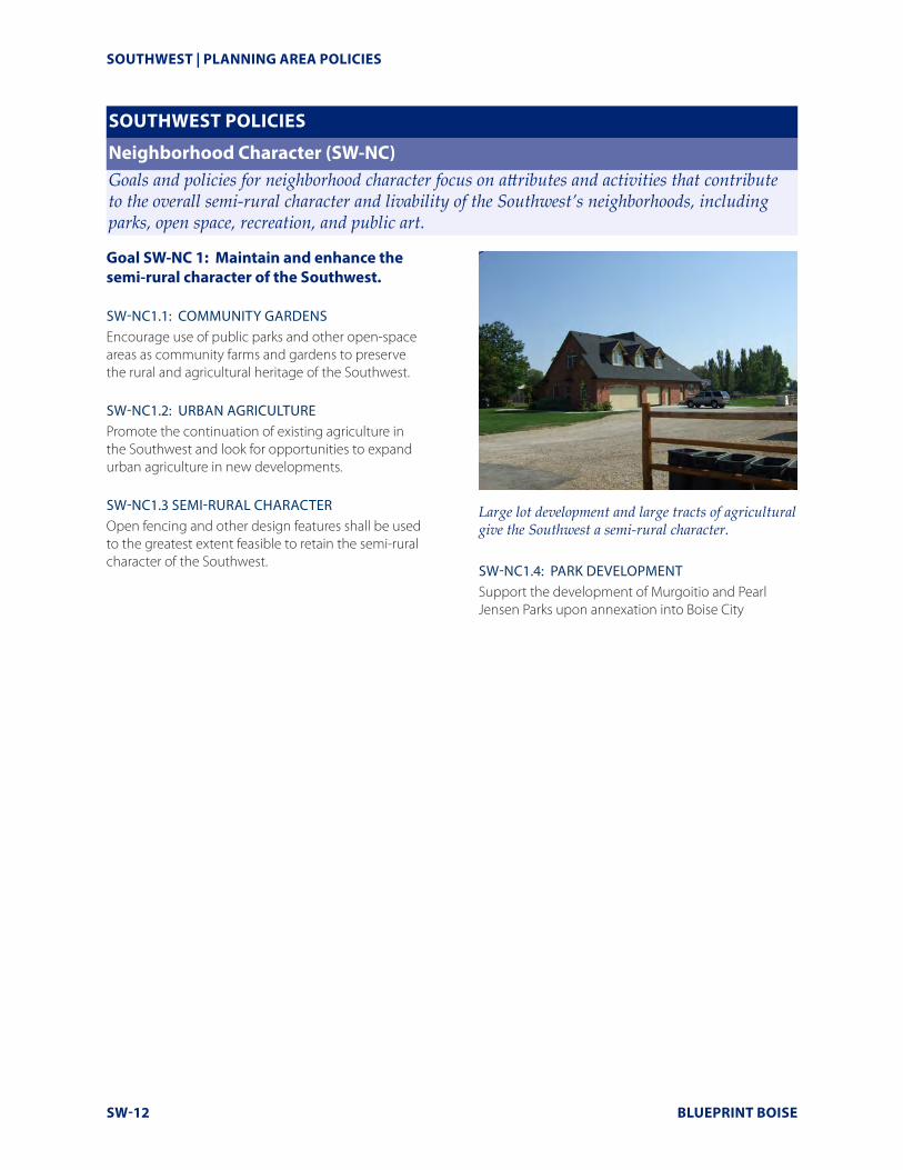
SW-NC1.3 SEMI-RURAL CHARACTEROpen fencing and other design features shall be used to the greatest extent feasible to retain the semi-rural character of the Southwest.
Large lot development and large tracts of agricultural give the Southwest a semi-rural character.
SW-NC1.4: PARK DEVELOPMENTSupport the development of Murgoitio and Pearl Jensen Parks upon annexation into Boise City