Southwest Asia - SCCPSSinternet.savannah.chatham.k12.ga.us/schools/gss/gradelevels/7th/Shared...
44
Presentation, Graphic Organizers, & Activities Southwest Asia:
Transcript of Southwest Asia - SCCPSSinternet.savannah.chatham.k12.ga.us/schools/gss/gradelevels/7th/Shared...

Presentation, Graphic Organizers, & Activities
Southwest Asia:

STANDARDS:SS7G7 Explain the impact of location, climate, physical characteristics, distribution of natural resources, and population distribution on Southwest Asia (Middle East). a. Describe how the deserts and rivers of Southwest Asia (Middle East) impact trade and affect where people live.
© Brain Wrinkles

TEACHER INFO: CLOZE Notes• The next pages are handouts for the
students to use for note-taking during the presentation. (Print front to back to save paper and ink.)
• Check the answers as a class after the presentation.
© Brain Wrinkles

Deserts•
There are ___________________ of land in the M
iddle East, and more than
half of it is covered by large desert areas.•
The most _
__________________ in the region is desert.
•The Rub al-
Khali ___________________ is in southern Saudi A
rabia.•
The ___________________ is located betw
een Syria and Iraq.
LIV
E•
The desert areas are not a favorable place to live due to the extremely
___________________ .
•Food and _
__________________ to find; how
ever, oases provide a temporary
water source.
•___________________(desert nom
ads) have called the desert home for
thousands of years.•
They live in ___________________ and in huts.
•Since the _
__________________ , m
ost people have moved aw
ay from the
desert areas.•
Over the last 50 years, residents have been exchanging the harsh nom
adic life for _
__________________ .
•In Saudi A
rabia, only about ___________________ rem
ains as nomadic
herders.
TRA
DE•
Many B
edouins are ___________________ herders.
•They trade anim
als and ___________________ w
ith people who live in tow
ns along the desert’s edge.
•M
ost people have left the desert behind and have moved to cities to
___________________ .
TRAV
EL•
People travel across the desert in ___________________ .
•Som
e even use All Terrain V
ehicles (ATV
s) to maneuver
___________________ .
©B
rain
Wrin
kle
s

Rivers
•The T
igris River runs through _
__________________ and joins w
ith the Euphrates to becom
e the Shatt al Arab, w
hich empties into the Persian G
ulf.•
The _
__________________ runs through Turkey, Syria, and I
raq.•
The _
__________________ form
s part of the border for Syria, Jordan, and
Israel.
LIV
E•
Cities are built near rivers to take advantage of the ___________________ in
Southwest A
sia.•
Access to w
ater for ___________________ m
ake the area much easier to live
in.•
Farmers grow
crops by rivers and in river valleys because they provide a ___________________ .
•Rivers also provide a good _
__________________ (fish).
•In countries that have a _
__________________ , the population increases
around port cities.•
Here, there are ___________________ in transportation, shipbuilding, and repair.
•Turkey has m
ajor port cities along the Aegean, B
lack, and ___________________
.•
Saudi Arabia has port cities along the Red Sea and _
__________________ .
WOR
K•
Cities and towns on rivers have becom
e major _
__________________ .
•M
ost people in these cities make a living w
orking in ___________________ .
•Rivers are also _
__________________ for people in cities to use to ship goods to
other merchants.
•___________________ are also im
portant areas of income for people w
ho live near rivers.
TRA
DERivers have alw
ays provided ___________________ for transportation.
People use boats for ___________________ along rivers.
Southwest A
sia’s waterw
ays are also important to _
__________________ because
they have helped make the region a center for shipping and trade for hundreds of
years.The region is a _
__________________ betw
een Asia, A
frica, and Europe.
©B
rain
Wrin
kle
s

Deserts•
There are 2.8 million m
iles of land in the Middle East, and m
ore than half of it is covered by large desert areas.
•The m
ost comm
on landform in the region is desert.
•The Rub al-
Khali (or “empty quarter”) is in southern Saudi A
rabia.•
The Great Syrian Desert is located betw
een Syria and Iraq.
LIV
E•
The desert areas are not a favorable place to live due to the extremely hot and
arid climate.
•Food and w
ater is difficult to find; however, oases provide a tem
porary water
source. •
Bedouins
(desert nomads) have called the desert hom
e for thousands of years.
•They live in tent cam
ps and in huts.
•Since the discovery of oil, m
ost people have moved aw
ay from the desert
areas.•
Over the last 50 years, residents have been exchanging the harsh nom
adic life for w
ork in the cities.•
In Saudi A
rabia, only about 1%
of the population remains as nom
adic herders.
TRA
DE•
Many B
edouins are sheep, camel, and goat herders.
•They trade anim
als and hand-m
ade goods with people w
ho live in towns along
the desert’s edge.•
Most people have left the desert behind and have m
oved to cities to find work.
TRAV
EL•
People travel across the desert in camel caravans.
•Som
e even use All Terrain V
ehicles (ATV
s) to maneuver across the sand.
©B
rain
Wrin
kle
s

Rivers
•The Tigris R
iver runs through Turkey and Iraq and joins w
ith the Euphrates to becom
e the Shatt al Arab, w
hich empties into the Persian G
ulf.•
The Euphrates River runs through Turkey, Syria, and I
raq.•
The Jordan R
iver forms part of the border for Syria, J
ordan, and Israel.
LIV
E•
Cities are built near rivers to take advantage of the scarce water sources in
Southwest A
sia.•
Access to w
ater for bathing and drinking make the area m
uch easier to live in.•
Farmers grow
crops by rivers and in river valleys because they provide a source of irrigation.
•Rivers also provide a good source of food (fish).
•In countries that have a deep-
sea harbor, the population increases around port cities.
•Here, there are em
ployment opportunities in transportation, shipbuilding, and
repair.•
Turkey has major port cities along the A
egean, Black, and M
editerranean Seas.•
Saudi Arabia has port cities along the Red Sea and Persian G
ulf.
WOR
K•
Cities and towns on rivers have becom
e major hubs of industry.
•M
ost people in these cities make a living w
orking in industrial factories.•
Rivers are also im
portant trade routes for people in cities to use to ship goods to other m
erchants.•
Farming and fishing are also im
portant areas of income for people w
ho live near rivers.
TRA
DERivers have alw
ays provided important routes for transportation.
People use boats for travel and trade along rivers.Southw
est Asia’s w
aterways are also im
portant to national economies because
they have helped make the region a center for shipping and trade for hundreds
of years.The region is a trade hub betw
een Asia, A
frica, and Europe.
©B
rain
Wrin
kle
s

Southwest Asia:
© Brain Wrinkles

© Brain Wrinkles
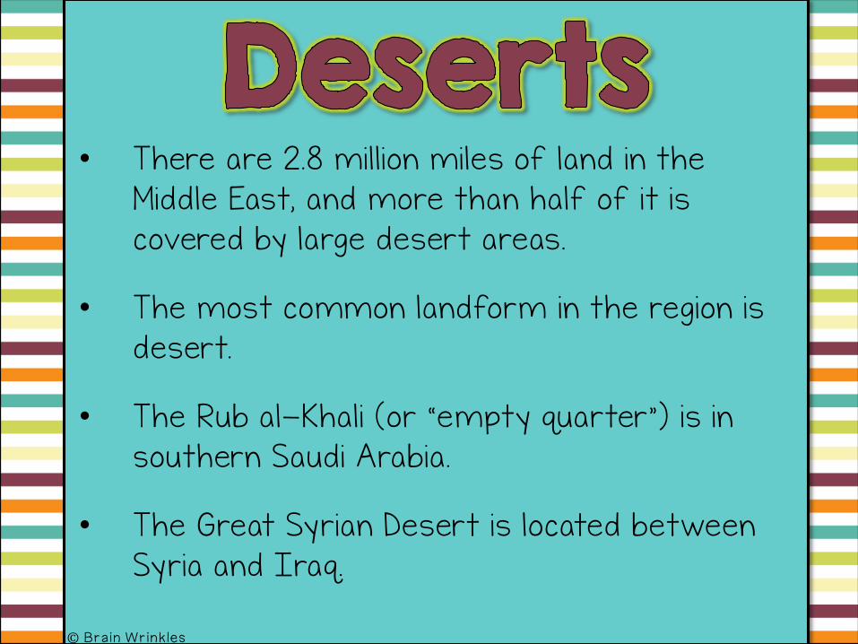
• There are 2.8 million miles of land in the Middle East, and more than half of it is covered by large desert areas.
• The most common landform in the region is desert.
• The Rub al-Khali (or “empty quarter”) is in southern Saudi Arabia.
• The Great Syrian Desert is located between Syria and Iraq.
© Brain Wrinkles

© Brain Wrinkles
In some places, temperatures can reach 125°F during the day.

• The desert areas are not a favorable place to live due to the extremely hot and arid climate.
• Food and water is difficult to find; however, oases provide a temporary water source.
• Bedouins (desert nomads) have called the desert home for thousands of years.• They live in tent camps and in huts.
© Brain Wrinkles

© Brain Wrinkles

• Since the discovery of oil, most people have moved away from the desert areas.
• Over the last 50 years, residents have been exchanging the harsh nomadic life for work in the cities.
• In Saudi Arabia, only about 1% of the population remains as nomadic herders.
© Brain Wrinkles

© Brain Wrinkles

• Many Bedouins are sheep, camel, and goat herders.
• They trade animals and hand-made goods with people who live in towns along the desert’s edge.
• Most people have left the desert behind and have moved to cities to find work.
© Brain Wrinkles

© Brain Wrinkles

• People travel across the desert in camel caravans.
• Some even use All Terrain Vehicles (ATVs) to maneuver across the sand.
© Brain Wrinkles

© Brain Wrinkles

© Brain Wrinkles

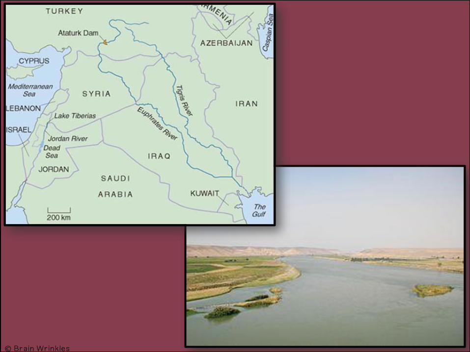
• The Tigris River runs through Turkey and Iraq and joins with the Euphrates to become the Shatt al Arab, which empties into the Persian Gulf.
• The Euphrates River runs through Turkey, Syria, and Iraq.
• The Jordan River forms part of the border for Syria, Jordan, and Israel.
© Brain Wrinkles
© Brain Wrinkles

• Cities are built near rivers to take advantage of the scarce water sources in Southwest Asia.
• Access to water for bathing and drinking make the area much easier to live in.
• Farmers grow crops by rivers and in river valleys because they provide a source of irrigation.
• Rivers also provide a good source of food (fish).
© Brain Wrinkles

© Brain Wrinkles
Baghdad, Iraq & the Tigris River

• In countries that have a deep-sea harbor, the population increases around port cities.
• Here, there are employment opportunities in transportation, shipbuilding, and repair.
• Turkey has major port cities along the Aegean, Black, and Mediterranean Seas.
• Saudi Arabia has port cities along the Red Sea and Persian Gulf.
© Brain Wrinkles

© Brain Wrinkles
Marmaris, Turkey

• Cities and towns on rivers have become major hubs of industry.• Most people in these cities make a living
working in industrial factories.
• Rivers are also important trade routes for people in cities to use to ship goods to other merchants.
• Farming and fishing are also important areas of income for people who live near rivers.
© Brain Wrinkles

© Brain Wrinkles
Al Aqaba, Jordan & the Jordan
River

• Rivers have always provided important routes for transportation.
• People use boats for travel and trade along rivers.
• Southwest Asia’s waterways are also important to national economies because they have helped make the region a center for shipping and trade for hundreds of years.
• The region is a trade hub between Asia, Africa, and Europe.
© Brain Wrinkles

© Brain Wrinkles

TEACHER INFO: Live & Trade Chart
• Print off the Where People Live, Work, & Trade graphic organizer for each student.
• Students will complete the graphic organizer after discussing the presentation. You can choose to let students work in pairs.
• Check answers as a class to be sure that all charts are completed correctly.
© Brain Wrinkles

© Brain Wrinkles
Description Where People Live Where People Work How People Trade
Deserts
Rivers
Directions: Complete the chart below after discussing the presentation.

© Brain Wrinkles
Description Where People Live Where People Work How People Trade
Deserts Most of SW Asia is covered in desert
Many people have moved out of the deserts & into cities in the past 50 years; Some Bedouins (nomads) still live there; food and water are scarce
most people left desert life behind and moved to cities for work
Bedouins are animal herders—trade animals and hand-made goods
Rivers
Tigris River, Euphrates River, Jordan River
Most people live in cities that are built around water sources (rivers); rivers provide water for drinking and bathing, irrigation for crops, and food (fish)
Many people work in factories or shipping industry in cities along rivers; farmers grow crops in river valleys
Rivers have always provided important routes for transportation.
People use boats for travel and trade along rivers.
Directions: Complete the chart below after discussing the presentation.

TEACHER INFO: Design A Plate
• Print off the Design A Plate handout for each student.
• Have the students design a plate that could be used in a Middle Eastern restaurant.
• The design should include symbols or facts that relate to how people live, work, and trade along the rivers and deserts in Southwest Asia.
• In the textbox, they will write a description that explains the symbols used in the plate’s design.
© Brain Wrinkles

Directions: Design a plate that could be used in a Middle Eastern restaurant. The plate’s design should include key symbols that relate to how people live, work, and trade along the rivers and deserts in Southwest Asia. In the textbox, you will explain your plate’s design and the significance of the symbols.
Plate’s Description:
© Brain Wrinkles

TEACHER INFO: Postcard
• Print off the Postcard handout for each student.
• Have the students imagine they are visiting either an area near a river or the desert in SW Asia.
• They will write a short note to their family describing how people live, work, and trade here.
• On the front of the postcard, they will draw an illustration of the place and include a short greeting.
© Brain Wrinkles

Directions: I
magine that you are visiting either an area near a river or the desert in SW
Asia. W
rite a short note to your fam
ily describing how people live, w
ork, and trade here. On the front, draw an
illustration of the place and include a short greeting.
Sou
thwe
st Asia
Postc
ard
Front
Back
©B
rain
Wrin
kle
s

TEACHER INFO: Comprehension Check
• Print off the Comprehension Check for each student.
• The students will complete this handout at the end of the lesson. You can count this as a quiz!
© Brain Wrinkles

1. W
hat is the most com
mon landform
in Southwest A
sia?
2. What is the clim
ate like in much of Southw
est Asia?
3. Who are the B
edouins?
4. How
have people living in the deserts of Southwest A
sia usually made
their living?
5. Why have m
any nomadic peoples left the deserts and m
oved to urban areas over the last 50
years?
6. What are m
any of the largest cities in Southwest A
sia located on or near?
7. What are som
e reasons why the areas around rivers are so heavily
populated:
©B
rain
Wrin
kle
s

1. W
hat is the most com
mon landform
in Southwest A
sia?Desert2. W
hat is the climate like in m
uch of Southwest A
sia?Hot and arid3. W
ho are the Bedouins?
Nom
adic peoples in Southwest A
sia who typically lived and m
oved around the deserts4. How
have people living in the deserts of Southwest A
sia usually made
their living?Trading livestock and hand-
made goods
5. Why have m
any nomadic peoples left the deserts and m
oved to urban areas over the last 50
years?Looking for jobs, especially after the discovery of oil6. W
hat are many of the largest cities in Southw
est Asia located on or
near?Rivers
7. What are som
e reasons why the areas around rivers are so heavily
populated:A
ccess to water for bathing and drinking, source of irrigation for
farming, source of food (fish), helpful for trade, lots of industry here =
lots of jobs for w
orkers
©B
rain
Wrin
kle
s

TEACHER INFO: TICKET OUT THE DOOR
• Have the students write a short summary of the lesson.
• You can choose to let them write in “texting language”, but I will warn you, this takes longer! I have them write out the summary in long-form first, and then if there is extra time, they can change some words to “txts”.
© Brain Wrinkles

Summarize today’s lesson in a short text message.
© Brain Wrinkles © Brain Wrinkles
Summarize today’s lesson in a short text message.
Name: Name:

Thank you so much for downloading this file. I sincerely hope you find it helpful and that your students learn a lot from it! I look forward to reading your feedback in my store.
If you like this file, you might want to check out some of my other products that teach social studies topics in creative, engaging, and hands-on ways.
Best wishes,
Ansley at Brain Wrinkles

© Brain Wrinkles. Your download includes a limited use license from Brain Wrinkles. The purchaser may use the resource for personal classroom use only. The license is not transferable to another person. Other teachers should purchase their own license through my store.
This resource is not to be used:• By an entire grade level, school, or district without purchasing the proper number of
licenses. For school/district licenses at a discount, please contact me.• As part of a product listed for sale or for free by another individual.• On shared databases.• Online in any way other than on password-protected website for student use only.
© Copyright Brain Wrinkles. All rights reserved. Permission is granted to copy pages specifically designed for student or teacher use by the original purchaser or licensee. The reproduction of any other part of this product is strictly prohibited. Copying any part of this product and placing it on the Internet in any form (even a personal/classroom website) is strictly forbidden. Doing so makes it possible for an Internet search to make the document available on the Internet, free of charge, and is a violation of the Digital Millennium Copyright Act (DMCA).
Thank you,
Ansley at Brain Wrinkles Clipart, fonts, & digital papers for this product
were purchased from: