SOUTHWEST AREA TRANSPORTATION AND LAND …nashvillempotest.nashville.gov/docs/SouthwestStudy/... ·...
14
SOUTHWEST AREA TRANSPORTATION AND LAND USE STUDY NASHVILLE AREA METROPOLITAN PLANNING ORGANIZATION SOUTHWEST AREA TRANSPORTATION AND LAND USE STUDY Transportation Plan Technical Memorandum - #5
Transcript of SOUTHWEST AREA TRANSPORTATION AND LAND …nashvillempotest.nashville.gov/docs/SouthwestStudy/... ·...
SOUTHWEST AREA TRANSPORTATION AND LAND USE STUDYNASHVILLE AREA METROPOLITAN PLANNING ORGANIZATION
SOUTHWEST AREA TRANSPORTATION ANDLAND USE STUDY
Transportation PlanTechnical Memorandum - #5
SOUTHWEST AREA TRANSPORTATION AND LAND USE STUDYNASHVILLE AREA METROPOLITAN PLANNING ORGANIZATION
TRANSPORTATION PLANTECH MEMO #5
PAGE 2
TRANSPORTATION PLAN
With the desirable land use conditi ons identi fi ed as the Preferred Growth (PG) scenario assumed as the 2035 growth conditi ons within the study area, the Southwest sub-region transportati on needs have been identi fi ed for this planning horizon. As discussed in Technical Memorandum 4, the majority of roadway needs will occur in transiti onal areas surrounding established citi es. Much of the land area where these needs will be present are currently within established urban growth boundaries, and are thus expected to be released from the jurisdicti on of the unincorporated county and become fully part of the respecti ve city in the future. This jurisdicti onal dynamic between city and unincorporated county will conti nue to be a source of required coordinati on, especially with regard to roadway planning. The transportati on improvements recommended in this Study are largely congruent with previous jurisdicti onal plans in eff ect within the study area.
The objecti ves of this Technical Memorandum are to inventory the transportati on needs already identi fi ed in the jurisdicti onal roadway planning eff orts, and provide the strategies needed to implement roadway improvement projects in accordance with the sub-regional growth objecti ves.
SOUTHWEST AREA TRANSPORTATION AND LAND USE STUDYNASHVILLE AREA METROPOLITAN PLANNING ORGANIZATION
TRANSPORTATION PLANTECH MEMO #5
PAGE 3
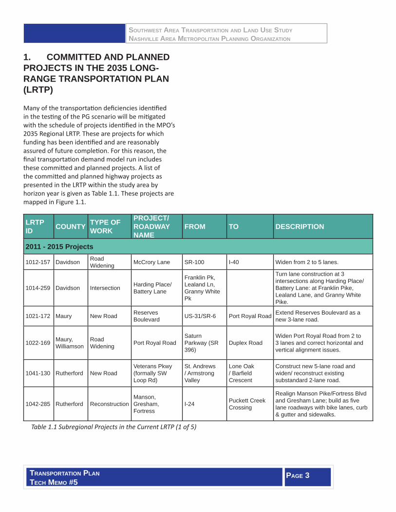
1. COMMITTED AND PLANNED PROJECTS IN THE 2035 LONG-RANGE TRANSPORTATION PLAN (LRTP)
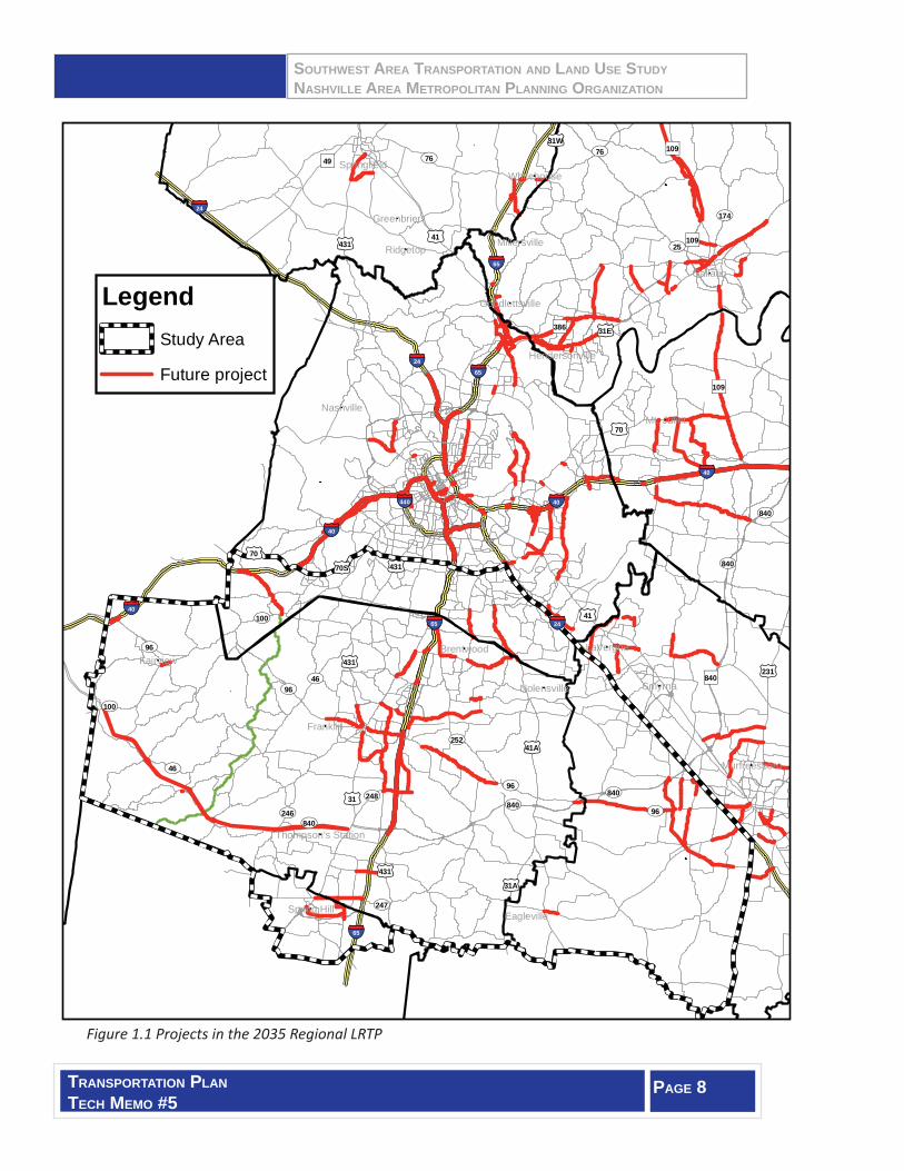
Many of the transportati on defi ciencies identi fi ed in the testi ng of the PG scenario will be miti gated with the schedule of projects identi fi ed in the MPO’s 2035 Regional LRTP. These are projects for which funding has been identi fi ed and are reasonably assured of future completi on. For this reason, the fi nal transportati on demand model run includes these committ ed and planned projects. A list of the committ ed and planned highway projects as presented in the LRTP within the study area by horizon year is given as Table 1.1. These projects are mapped in Figure 1.1.
LRTP ID COUNTY TYPE OF
WORK
PROJECT/ ROADWAY NAME
FROM TO DESCRIPTION
2011 - 2015 Projects
1012-157 Davidson Road Widening McCrory Lane SR-100 I-40 Widen from 2 to 5 lanes.
1014-259 Davidson Intersection Harding Place/Battery Lane
Franklin Pk, Lealand Ln, Granny White Pk
Turn lane construction at 3 intersections along Harding Place/ Battery Lane: at Franklin Pike, Lealand Lane, and Granny White Pike.
1021-172 Maury New Road Reserves Boulevard US-31/SR-6 Port Royal Road Extend Reserves Boulevard as a
new 3-lane road.
1022-169 Maury, Williamson
Road Widening Port Royal Road
Saturn Parkway (SR 396)
Duplex Road Widen Port Royal Road from 2 to 3 lanes and correct horizontal and vertical alignment issues.
1041-130 Rutherford New Road Veterans Pkwy (formally SW Loop Rd)
St. Andrews / Armstrong Valley
Lone Oak / Barfi eld Crescent
Construct new 5-lane road and widen/ reconstruct existing substandard 2- lane road.
1042-285 Rutherford Reconstruction Manson, Gresham, Fortress
I-24 Puckett Creek Crossing
Realign Manson Pike/Fortress Blvd and Gresham Lane; build as fi ve lane roadways with bike lanes, curb & gutter and sidewalks.
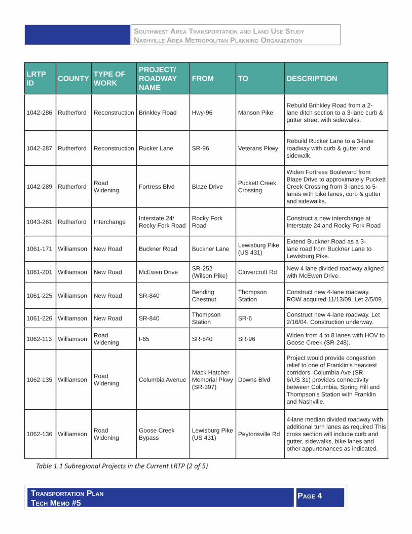
Table 1.1 Subregional Projects in the Current LRTP (1 of 5)
SOUTHWEST AREA TRANSPORTATION AND LAND USE STUDYNASHVILLE AREA METROPOLITAN PLANNING ORGANIZATION
TRANSPORTATION PLANTECH MEMO #5
PAGE 4
LRTP ID COUNTY TYPE OF
WORK
PROJECT/ ROADWAY NAME
FROM TO DESCRIPTION
1042-286 Rutherford Reconstruction Brinkley Road Hwy-96 Manson Pike Rebuild Brinkley Road from a 2-lane ditch section to a 3-lane curb & gutter street with sidewalks.
1042-287 Rutherford Reconstruction Rucker Lane SR-96 Veterans Pkwy Rebuild Rucker Lane to a 3-lane roadway with curb & gutter and sidewalk.
1042-289 Rutherford Road Widening Fortress Blvd Blaze Drive Puckett Creek
Crossing
Widen Fortress Boulevard from Blaze Drive to approximately Puckett Creek Crossing from 3-lanes to 5-lanes with bike lanes, curb & gutter and sidewalks.
1043-261 Rutherford Interchange Interstate 24/Rocky Fork Road
Rocky Fork Road
Construct a new interchange at Interstate 24 and Rocky Fork Road
1061-171 Williamson New Road Buckner Road Buckner Lane Lewisburg Pike (US 431)
Extend Buckner Road as a 3-lane road from Buckner Lane to Lewisburg Pike.
1061-201 Williamson New Road McEwen Drive SR-252 (Wilson Pike) Clovercroft Rd New 4 lane divided roadway aligned
with McEwen Drive.
1061-225 Williamson New Road SR-840 Bending Chestnut
Thompson Station
Construct new 4-lane roadway. ROW acquired 11/13/09. Let 2/5/09.
1061-226 Williamson New Road SR-840 Thompson Station SR-6 Construct new 4-lane roadway. Let
2/16/04. Construction underway.
1062-113 Williamson Road Widening I-65 SR-840 SR-96 Widen from 4 to 8 lanes with HOV to
Goose Creek (SR-248).
1062-135 Williamson Road Widening Columbia Avenue
Mack Hatcher Memorial Pkwy (SR-397)
Downs Blvd
Project would provide congestion relief to one of Franklin’s heaviest corridors. Columbia Ave (SR 6/US 31) provides connectivity between Columbia, Spring Hill and Thompson’s Station with Franklin and Nashville.
1062-136 Williamson Road Widening
Goose Creek Bypass
Lewisburg Pike (US 431) Peytonsville Rd
4-lane median divided roadway with additional turn lanes as required This cross section will include curb and gutter, sidewalks, bike lanes and other appurtenances as indicated.
Table 1.1 Subregional Projects in the Current LRTP (2 of 5)

SOUTHWEST AREA TRANSPORTATION AND LAND USE STUDYNASHVILLE AREA METROPOLITAN PLANNING ORGANIZATION
TRANSPORTATION PLANTECH MEMO #5
PAGE 5
LRTP ID COUNTY TYPE OF WORK
PROJECT/ ROADWAY NAME
FROM TO DESCRIPTION
1062-137 Williamson Road Widening Hillsboro Rd. New Hwy SR-
96 W/Bridge St
Mack Hatcher Memorial Pkwy (SR 397)
3-lane with continuous center turn lane, bike lanes, sidewalks and street lighting from Del Rio to Mack Hatcher (SR 397). 4-lane with bike lanes, sidewalks and street lighting from New Hwy 96 W/Bridge St to Del Rio.
1062-138 Williamson Road Widening Lewisburg Pike
Goose Creek Bypass (SR-248)
Mack Hatcher Memorial Pkwy (SR-397)
4-lane median divided with multi-use path and curb and gutter.
1062-141 Williamson Road Widening McEwen Drive Carothers
Parkway East Cool Springs Blvd
Widen and improve McEwen Drive to four lanes from Carothers Parkway to East Cool Springs Blvd.
1062-142 Williamson Road Widening McEwen Drive East Cool
Springs Blvd Wilson Pike (SR 252)
Widen and improve McEwen Drive to four lanes from East Cool Springs to SR 252 (Wilson Pike).
1062-159 Williamson Road Widening
Concord Road (S.R. 253) SR-252 Arrowhead
Drive
Widen from 2 to 3 lanes, includes 2 travel lanes and a continuous center turn lane, elimination of hazardous curves. Bikeway/walkway separated by 4’ green strip on south side of road with sidewalk under consideration on north side.
1062-160 Williamson Road Widening Franklin Road Moores Lane
(SR-441) Concord Road (SR-253)
Widening of Franklin Rd (US-31) from two to fi ve lanes including a continuous center turn lane, with a curb and gutter section. Project would also include a 10 ft wide bikeway/walkway on west side placed a minimum of 4 ft behind the curb.
1062-162 Williamson Road Widening Split Log Road Ragsdale Road Pleasant Hill Rd
Widening to provide 12 foot travel lanes and elimination of sight distance problems. Includes center turn lanes for certain segments, especially for subdivision entrances with strategically placed medians to provide traffi c calming features.
1062-170 Williamson Road Widening
Duplex Road (SR 247) SR 6 (US 31) I-65
Widen Duplex Road from 2 to 3 lanes with shoulders and sidewalks, and remove vertical curves with sight distance issues.
Table 1.1 Subregional Projects in the Current LRTP (3 of 5)
SOUTHWEST AREA TRANSPORTATION AND LAND USE STUDYNASHVILLE AREA METROPOLITAN PLANNING ORGANIZATION
TRANSPORTATION PLANTECH MEMO #5
PAGE 6
LRTP ID COUNTY TYPE OF
WORK
PROJECT/ ROADWAY NAME
FROM TO DESCRIPTION
1062-346 Williamson, Davidson
Road Widening
Concord Road (S.R. 253)
Edmonson Pike
Nolensville Road (US-31A/41A)
Widen to 3 lanes with 10’ multi-use path along the south side of the road.
1064-252 Williamson Intersection SR-106 (Hillsboro Rd)
SR-46 (Old Hillsboro Rd) Realign existing intersection.
2016 - 2025 Projects
1042-231 Rutherford Road Widening SR-96 SR-840 Overall Creek
Reconstruct from 2 to 5 lanes with curb and gutter. PE completed 7/15/98.
1042-232 Rutherford Road Widening SR-99 SR-16 in
Eagleville Swamp Road (W of Concord)
Construct new alignment from SR-16 to Swamp Rd as a 2 lane with continuous center turn lane; from Swamp Road, improve existing alignment to 2 lane. Reconstruction from US 41A (SR-16) to SR-269 Let 12/14/07.
1062-143 Williamson Road Widening Murfreesboro Rd S Margin St North Royal
Oaks Blvd.
3-lane cross section with shared lanes and continuous two way left turn lane, 5 foot parkway strips and 5 foot sidewalks from Third Ave (Harpeth River Bridge) to Mack Hatcher Memorial Parkway. 7-lane cross section with bike lanes and continuous two way left turn lane.
1062-170 Williamson Road Widening
Duplex Road (SR 247) SR 6 (US 31) I-65
Widen Duplex Road from 2 to 3 lanes with shoulders and sidewalks, and remove vertical curves with sight distance issues.
1062-215 Williamson Road Widening SR-96 Mack Hatcher
Pkwy (SR 397)Hillsboro Road/ SR-106
Widen from 2 to 4 lanes with curb and gutter.
1062-234 Williamson Road Widening SR-96 Arno Road Wilson Pike
(SR-252)
Widen from 2 to 4 lanes with curb and gutter. ROW underway 10/28/02.
1062-346 Williamson, Davidson
Road Widening
Concord Road (S.R. 253)
Edmonson Pike
Nolensville Road (US-31A/41A)
Widen to 3 lanes with 10’ multi-use path along the south side of the road.
1064-252 Williamson Intersection SR-106 (Hillsboro Rd)
SR-46 (Old Hillsboro Rd) Realign existing intersection.
1062-163 Williamson Road Widening
Wilson Pike (SR-252)
Concord Road (S.R. 253) Church Street
Widen Wilson Pike (SR 252) to provide for improved safety and improved traffi c fl ow. Four alternate cross-sections have been proposed, all of which provide for two twelve (12) foot travel lanes and 2-6 foot shoulders.
Table 1.1 Subregional Projects in the Current LRTP (4 of 5)

SOUTHWEST AREA TRANSPORTATION AND LAND USE STUDYNASHVILLE AREA METROPOLITAN PLANNING ORGANIZATION
TRANSPORTATION PLANTECH MEMO #5
PAGE 7
LRTP ID COUNTY TYPE OF
WORK
PROJECT/ ROADWAY NAME
FROM TO DESCRIPTION
1063-166 Williamson Interchange I-65 n/a New interchange on I-65 between Old Hickory Blvd and Concord Road (SR 253).
1064-164 Williamson Interchange I-65 Interchange with Moores Lane (S.R. 441)
n/a
Modify southbound I-65 exit ramp to eastbound Moores Lane. Eliminate dual lane confl ict between traffi c merging on to eastbound Moores Lane and traffi c exiting eastbound Moores Lane to enter the I-65 northbound entrance ramp. May include other modifi cations.
1064-165 Williamson Interchange I-65 Interchange with Concord Road (S.R.253)
n/a Modify southbound I-65 exit ramp and the exit ramp signals.
1064-253 Dickson, Williamson Interchange I-40 SR-96 Reconstruct substandard cloverleaf
design.
2026 - 2035 Projects
1012-148 Davidson Road Widening Edmonson Pike Davidson Co.
Line (Holt Rd)Old Hickory Blvd (SR-254) Widen from 2 to 5 lanes.
1012-185 Davidson Road Widening
Nolensville Pike (SR-11) Burkitt Road Old Hickory
Blvd (SR-254) Widen from 2 to 5 lanes.
1042-124 Rutherford Road
Widening SR-99 (New Salem Rd) Cason Ln Old Fort (SR-
96) Widen from 2 to 5 lanes.
1043-261 Rutherford Interchange Interstate 24/
Rocky Fork Road Rocky Fork Road Construct a new interchange at
Interstate 24 and Rocky Fork Road.
1062-134 Williamson Road
Widening Columbia Avenue Downs Blvd Fowlkes Street
Project would complete link between current Franklin Corridor and Connector Streets Economic Development Project phases north of the project terminus and the Columbia Ave South widening project between Mack Hatcher (SR 397) and Downs Blvd.
1062-139 Williamson Road Widening
Mack Hatcher Memorial Parkway
Murfreesboro Rd. (SR 96E)
Franklin Rd. (SR 6/US 31)
Widen to 4-lane divided with multi-use pathway.
1062-140 Williamson Road Widening
Mack Hatcher Memorial Parkway
Columbia Pike (SR-6/US-31)
Murfreesboro Rd (SR-96E)
Widen to 4-lane divided with a multi-use pathway
Table 1.1 Subregional Projects in the Current LRTP (5 of 5)
SOUTHWEST AREA TRANSPORTATION AND LAND USE STUDYNASHVILLE AREA METROPOLITAN PLANNING ORGANIZATION
TRANSPORTATION PLANTECH MEMO #5
PAGE 8
Figure 1.1 Projects in the 2035 Regional LRTP
£¤41
£¤70
£¤70
£¤41
£¤31
£¤31A£¤431
£¤70S
£¤231
£¤31E
£¤41A
£¤31W
£¤431
£¤431
£¤431
")49
")840
")109
")109
")386
")109
Smyrna
Ridgetop
LaVergneFairview
Franklin
Gallatin
Brentwood
Nashville
Eagleville
Greenbrier
Mt. Juliet
Whitehouse
Nolensville
Spring Hill
Springfield
Millersville
Murfreesboro
Goodlettsville
Hendersonville
Thompson's Station
§̈¦65
§̈¦24
§̈¦24
§̈¦40
§̈¦24
§̈¦65
§̈¦65
§̈¦65
§̈¦40
§̈¦40
§̈¦40
§̈¦440
UV46
UV46
UV96
UV96
UV76UV76
UV25
UV96
UV96
UV840UV246
UV252
UV248
UV247
UV840
UV100
UV840
UV174
UV100
UV840
UV840
LegendStudy Area
Future project
SOUTHWEST AREA TRANSPORTATION AND LAND USE STUDYNASHVILLE AREA METROPOLITAN PLANNING ORGANIZATION
TRANSPORTATION PLANTECH MEMO #5
PAGE 9
2. OTHER JURISDICTIONAL PLANS
In additi on to those committ ed and planned projects found in the 2035 Regional LRTP, several of the jurisdicti ons within the study area maintain transportati on plans of their own. These local plans are regarded somewhat diff erently for several reasons.
• The Regional LRTP includes only projects which are fi nancially constrained by anti cipated revenues. Most local transportati on plans in the Southwest sub-region are draft ed without comparison to corresponding revenue sources.
• Planned projects in the Regional LRTP have a planning horizon for anti cipated completi on. Local plans generally consider a long-term planning horizon (20-25 years), but individual projects are not given an anti cipated completi on date.
• Regional projects are generally completed with state and/or federal funding sources and thus follow specifi c planning, programmati c, and design requirements. Locally planned projects are oft en completed in coordinati on with local development initi ati ves, may be completed with private funding, and therefore may be exempt from certain requirements.
• The Regional LRTP considers the mobility needs of the region, using analysis of a regional-scaled transportati on model. Local plans are more fi ne-grained; they may include smaller local roads and may not concern themselves with transportati on defi ciencies outside of their respecti ve jurisdicti ons.
Similar to the Regional LRTP projects, however, locally planned projects have generally undergone some level of public review and comment as well as a formal politi cal adopti on process. This does not ensure public support of each project through the design and constructi on phases, but does provide a reasonable level of local understanding and approval of the projects in concept. For this reason, projects found in locally adopted transportati on plans within the study area are considered to be recommendati ons for future improvement within
the Southwest sub-region. Lists and maps of these projects as documented in local transportati on plans are given as an appendix to this technical memorandum.
3. SOUTHWEST SUB-REGIONAL TRANSPORTATION PLAN
As demonstrated through the regional land use analysis detailed in Technical Memorandums 2 through 4, certain transportati on defi ciencies are expected to occur in the absence of roadway improvements and additi ons. The committ ed and planned projects of the regional LRTP as well as the locally planned projects described above, when completed, are expected to signifi cantly address the regional and many of the local transportati on needs across the study area. Because each of these adopted plans strive to meet the long-range growth, development, and associated mobility-related planning objecti ves of the study area, the recommendati ons of this Southwest sub-regional study have been developed around three general plan strategies:
1. Work towards developing a more robust sub-regional transportati on network by planning for a coordinated system of faciliti es within the study area. Because local plans in most jurisdicti ons provide for good local mobility, what is left is to knit these plans together by means of a transportati on plan for unincorporated Williamson County, the one enti ty that connects all the jurisdicti ons of the sub-region together geographically and politi cally. The major emphasis of Technical Memorandum 6 is the implementati on of this primary recommendati on of the sub-regional analysis. The recommendati ons
SOUTHWEST AREA TRANSPORTATION AND LAND USE STUDYNASHVILLE AREA METROPOLITAN PLANNING ORGANIZATION
TRANSPORTATION PLANTECH MEMO #5
PAGE 10
from this analysis have been formulated for adopti on into the updated Williamson County Major Thoroughfare Plan for projects within unincorporated Williamson County.
2. Conti nue to plan and implement improvements congruent with regional growth objecti ves as developed by the MPO. Using what is known about high growth areas of the sub-region from the PG scenario coupled with informati on on local development trends, certain corridors stand to face increasing challenges. These challenges should be met in accordance with the region’s decided goals in mind.
3. Build increasingly closer coordinati on linkages between adjacent planning jurisdicti ons in the study area. Several project areas in the sub-region highlight the need for increased coordinati on. As with the transportati on network, unincorporated Williamson County faces the challenge of increasing coordinati on the most as it is the sole enti ty adjacent to other sub-regional jurisdicti ons.
3.1 Work Towards a Sub-Regional Transportation Network
As menti oned, the combinati on of regional-scale projects found in the LRTP and the more localized proposed roadway projects found in jurisdicti onal plans generally account for the long-range transportati on needs across the sub-region. The primary recommendati on of this study is development of the “missing piece” of a coordinated sub-regional roadway network.
Specifi cally, this is the development of an updated Major Thoroughfare Plan for the unincorporated porti ons of Williamson County.
The previous Major Thoroughfare Plan for Williamson County was completed in 1996 and has been the basis for roadway planning in the county since. As study area jurisdicti ons have grown, and parti cularly since the passage of PC 1101, the overlapping planning jurisdicti ons within the Urban Growth Boundaries have changed the dynamic of County plans. The sub-regional road plan should seek to introduce sub-regional conti nuity to locally planned projects and to reconcile inconsistencies that exist between multi ple city and town plans.
Specifi cs regarding this primary study recommendati on, the development of an updated Major Thoroughfare Plan for Williamson County, are detailed in Technical Memorandum 6.
3.2 Preserve and Promote Regional Goals in Project Delivery in Key Corridors
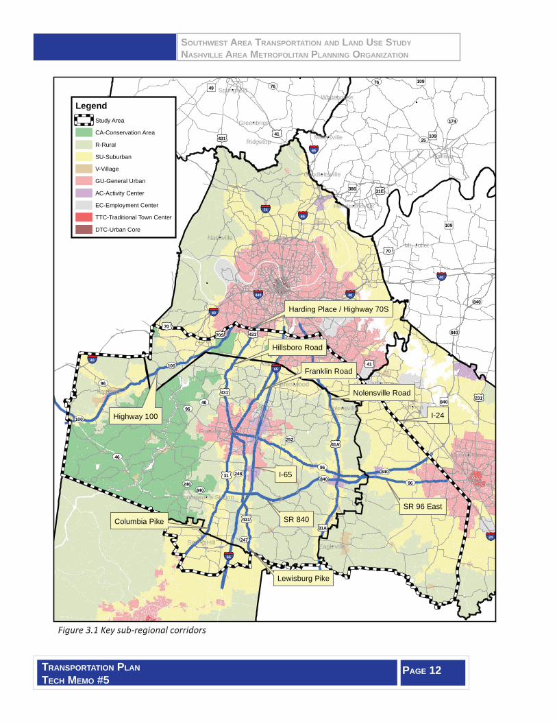
Certain corridors across the study area have the potenti al to substanti ally shape the sub-regional form and functi on as it grows over the next 25 years. Based on growth projecti ons and the envisioned character areas of each, these corridors will each play key roles in shaping the communiti es that they provide access to. These sub-regional corridors are:
Harding Place/Highway 70S: This corridor is the northern boundary of the study area and extends across I-24, I-65, and I-40 in Davidson County. The corridor transects general urban, suburban, village, and rural characters areas as defi ned in the PG scenario. Managing these character area transiti ons should especially follow MPO Goals 2, 3, and 6 to promote effi cient cross-travel through southern Davidson County. Goal 5 will also be important in promoti ng Bellevue Center as a regional acti vity center.
Highway 100: The criti cal link for Fairview and northwestern Williamson County, Highway 100 will be
SOUTHWEST AREA TRANSPORTATION AND LAND USE STUDYNASHVILLE AREA METROPOLITAN PLANNING ORGANIZATION
TRANSPORTATION PLANTECH MEMO #5
PAGE 11
shaped by special att enti on to Goals 2, 3, and 7. Goal 4 will be especially important as Highway 100 crosses areas of complex geography near the Davidson/Williamson County Line.
Hillsboro and Franklin Roads: Generally already developed, these corridors may see growing redevelopment pressures in both commercial and residenti al areas. Hillsboro Road will require special att enti on as road widening becomes more of a need in keeping with Goal 2.
Nolensville Road: This corridor will bisect areas categorized as general urban, suburban, and rural, but the character area of the corridor itself is classifi ed as suburban in the PG. Maintaining desirable densiti es and access along the corridor in keeping with its suburban designati on (and the resulti ng protecti on of rural areas just off the corridor) will further regional Goals 3, 4, and 7.
State Route 96 East: Sti ll considered a primary sub-regional connecti on from Franklin to Murfreesboro, this corridor will conti nue to play an increasingly access-oriented role as development extends east out of Franklin. Traffi c capacity will be required to accommodate the suburban growth patt erns envisioned by the PG. Contextually appropriate roadway features will be required in village areas like Arrington and Triune. Goals 2, 3, 5, and 7 will especially help shape State Route 96 East.
Columbia and Lewisburg Pikes: Having common roles of linking central Williamson County (Franklin – Thompson’s Stati on – Spring Hill) these arterials will conti nue to transiti on from urban into suburban
corridors heading south from Franklin. In the high-growth communiti es of southern Williamson County, planning for land use densiti es in accordance with roadway capaciti es will be criti cal. Simultaneously, looking for ways to add capacity in already built areas will remain a challenge. Adherence to Goals 2, 3, 6 and 7 will produce success for these corridors in the southern part of the study area.
Access-Controlled Corridors: The interstate routes in the study area as well as State Route 840 will obviously conti nue to shape transportati on in the Southwest sub-region signifi cantly. A major considerati on for these corridors is found in regional Goal 5. Inherent in preserving these highway faciliti es as major economic tools is protecti ng their safety (Goal
1), and capacity (Goal 2).
The sub-regional key corridors are shown in Figure 3.1.
Regional Goals
Goal #1: Maintain and Preserve the Effi ciency, Safety, and Security of the Region’s Existi ng Transportati on Infrastructure.
Goal #2: Manage Congesti on to Keep People and Goods Moving.
Goal #3: Encourage Quality Growth and Sustainable Land Development Practi ces.
Goal #4: Protect the Region’s Health & Environment.
Goal #5: Support the Economic Competi ti veness of the Greater Nashville Area.
Goal #6: Off er Meaningful Transportati on Choices for a Diverse Populati on Including the Aging.
Goal #7: Encourage Regional Coordinati on, Cooperati on, & Decision Making.
Goal #8: Practi ce Thoughtf ul, Transparent Financial Stewardship by Ensuring that Transportati on Improvements meet Regional Goals.
SOUTHWEST AREA TRANSPORTATION AND LAND USE STUDYNASHVILLE AREA METROPOLITAN PLANNING ORGANIZATION
TRANSPORTATION PLANTECH MEMO #5
PAGE 12
Figure 3.1 Key sub-regional corridors
£¤41
£¤70
£¤70
£¤41
£¤31
£¤31A£¤431
£¤70S
£¤231
£¤31E
£¤41A
£¤431
£¤431
£¤431
")49
")840
")109
")109
")386
")109
Smyrna
Ridgetop
LaVergneFairview
Franklin
Gallatin
Brentwood
Nashville
Eagleville
Greenbrier
Mt. Juliet
Whitehouse
Nolensville
Spring Hill
Springfield
Millersville
Murfreesboro
Goodlettsville
Hendersonville
Thompson's Station
§̈¦65
§̈¦24
§̈¦24
§̈¦40
§̈¦24
§̈¦24
§̈¦65
§̈¦65
§̈¦65
§̈¦40
§̈¦40
§̈¦40
§̈¦440
UV46
UV46
UV96
UV96
UV76UV76
UV25
UV96
UV96
UV840UV246
UV252
UV248
UV247
UV840
UV100
UV840
UV174
UV100
UV840
UV840
LegendStudy Area
CA-Conservation Area
R-Rural
SU-Suburban
V-Village
GU-General Urban
AC-Activity Center
EC-Employment Center
TTC-Traditional Town Center
DTC-Urban Core
Harding Place / Highway 70S
Highway 100
Hillsboro Road
Franklin Road
Nolensville Road
SR 96 East
Columbia Pike
Lewisburg Pike
I-65
SR 840
I-24
SOUTHWEST AREA TRANSPORTATION AND LAND USE STUDYNASHVILLE AREA METROPOLITAN PLANNING ORGANIZATION
TRANSPORTATION PLANTECH MEMO #5
PAGE 13
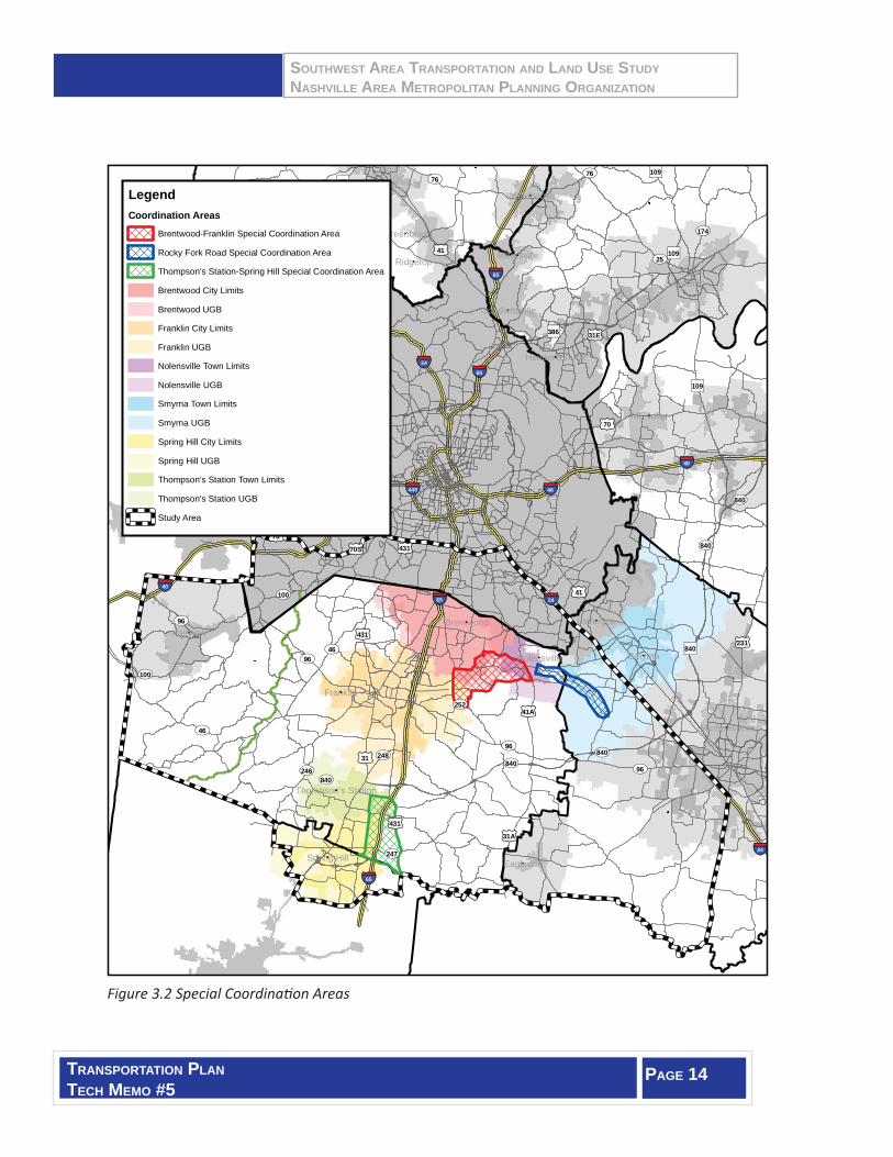
3.3 Build Stronger Linkages in Jurisdictional Coordination
For many years, the jurisdicti ons of this area have worked well together in administering deliberate land use and transportati on objecti ves. These partnerships conti nue and should be both maintained and strengthened as added pressures in development grow. There are three areas of the sub-region where the City Limits, Urban Growth Boundaries, and even county boundaries create unique coordinati on challenges.
One “criti cal coordinati on” area is the Wilson Pike/Clovercroft Road area where Brentwood, Franklin, and Williamson County meet. As annexati on and residenti al subdivision projects have occurred, planning staff s of these agencies have adapted local plans to develop a coordinated approach to transportati on needs.
The Rocky Fork Road corridor will require special coordinati on with its improvement and emergence as a primary sub-regional route and growth corridor. The Towns of Nolensville and Smyrna as well as unincorporated Williamson and Rutherford Counti es all have some level of planning jurisdicti on within the corridor and all expect to see increasing future growth along this corridor.
The third coordinati on area is the I-65 corridor between Thompson’s Stati on and Spring Hill. Along with Williamson County, these agencies have partnered on a study of this corridor to determine key access needs. As new development and roadway planning conti nues, this area too will require close on-going coordinati on.
The special coordinati on areas are shown in Figure 3.2.
SOUTHWEST AREA TRANSPORTATION AND LAND USE STUDYNASHVILLE AREA METROPOLITAN PLANNING ORGANIZATION
TRANSPORTATION PLANTECH MEMO #5
PAGE 14
Figure 3.2 Special Coordinati on Areas
£¤41
£¤70
£¤70
£¤41
£¤31
£¤31A£¤431
£¤70S
£¤231
£¤31E
£¤41A
£¤431
£¤431
£¤431
")49
")840
")109
")109
")386
")109
Smyrna
Ridgetop
LaVergneFairview
Franklin
Gallatin
Brentwood
Nashville
Eagleville
Greenbrier
Mt. Juliet
Whitehouse
Nolensville
Spring Hill
Springfield
Millersville
Murfreesboro
Goodlettsville
Hendersonville
Thompson's Station
§̈¦65
§̈¦24
§̈¦24
§̈¦40
§̈¦24
§̈¦24
§̈¦65
§̈¦65
§̈¦65
§̈¦40
§̈¦40
§̈¦40
§̈¦440
UV46
UV46
UV96
UV96
UV76UV76
UV25
UV96
UV96
UV840UV246
UV252
UV248
UV247
UV840
UV100
UV840
UV174
UV100
UV840
UV840
LegendCoordination Areas
Brentwood-Franklin Special Coordination Area
Rocky Fork Road Special Coordination Area
Thompson's Station-Spring Hill Special Coordination Area
Study Area
Brentwood City Limits
Franklin City Limits
Nolensville Town Limits
Brentwood UGB
Franklin UGB
Smyrna Town Limits
Spring Hill City Limits
Thompson's Station Town Limits
Nolensville UGB
Smyrna UGB
Spring Hill UGB
Thompson's Station UGB