Southern Tasmania Industrial Land Strategy -...
78
130715 STCA Industrial Land Strategy Final July 2013_no tracked changes Southern Tasmania Industrial Land Strategy Stage 2 Final Report Southern Tasmanian Councils Authority Department of Economic Development, Tourism and Arts July 2013
Transcript of Southern Tasmania Industrial Land Strategy -...

130715 STCA Industrial Land Strategy Final July 2013_no tracked changes
Southern Tasmania Industrial Land Strategy Stage 2 Final Report Southern Tasmanian Councils Authority Department of Economic Development, Tourism and Arts July 2013

130715 STCA Industrial Land Strategy Final July 2013_no tracked changes
This report has been prepared on behalf of Department of Economic Development, Tourism and Arts. It was substantially funded by the Department of Economic Development, Tourism and Arts with significant financial in-kind support from the Southern Tasmanian Councils.SGS Economics and Planning and its associated consultants are not liable to any person or entity for any damage or loss that has occurred, or may occur, in relation to that person or entity taking or not taking action in respect of any representation, statement, opinion or advice referred to herein. SGS Economics and Planning Pty Ltd ACN 007 437 729 www.sgsep.com.au Offices in Brisbane, Canberra, Hobart, Melbourne, Sydney

Southern Tasmania Industrial Land Strategy
TABLE OF CONTENTS
1 INTRODUCTION 1 1.1 Aim of the Strategy 1 1.2 Scope of the Strategy 1 1.3 Remainder of this Strategy 2
2 THE TASK FOR INDUSTRIAL LAND 3 2.1 Task for this Strategy 3 2.2 Overview Site Assessment Method 4 2.3 Strategic Planning Objectives in Southern Tasmania 5
Summary of Strategic Planning Objectives 8
3 FUTURE OPTIONS ASSESSMENT 9 3.1 Potential Future Sites for Industrial Use 9 3.2 Overview of sites 9 3.3 Short profiles of suitable sites 12 3.4 Overview 16
4 INDUSTRIAL LAND USE STRATEGY 18 4.1 Objective 18 4.2 Overview of Future Industrial Sites 18 4.3 Strategy Scope 20 4.4 Measures to Manage Industrial Land Availability 21 4.5 Sequencing and Timing Considerations 22 4.6 Overview and Maps 26 4.7 Conditions for Regionally Significant Sites 36
Minimum and maximum lot sizes 36 The intended use of regionally significant sites 36 Staging of Land Development 37
4.8 Monitoring and Review 38 Appendices Appendix 1 First Step Option Assessment – Fact Sheets ........................................................................................ 39 Appendix 2 Overview of Government-owned land organisations in Australia ....................................................... 68 List of Tables Table 1 Common location criteria for industry businesses by category .................................................................. 5 Table 2 Long list of potential future industrial options ........................................................................................... 9 Table 3 First Step Assessment Summary Overview ............................................................................................... 11 Table 4 List of Options after first step assessment ................................................................................................ 12 Table 5 Potential future supply of industrial land, by Council ............................................................................... 17 Table 6 Potential Future Sites, by significance and industry focus ........................................................................ 17 Table 7 Industrial Land to 2026 and 2041 ............................................................................................................. 26

Southern Tasmania Industrial Land Strategy
List of Figures Figure 1 Overview map of Future Industrial Sites in Southern Tasmania ............................................................... 19 Figure 2 Greater Hobart sales & prices of industrial land, 2005-06 to 2009-10 ..................................................... 23 Figure 3 Brighton-Bridgewater transport Hub and Cove Hill area .......................................................................... 27 Figure 4 Brighton Bridgewater, including Tea Tree Road ........................................................................................ 28 Figure 5 Clarence .................................................................................................................................................... 30 Figure 6 Clarence, Mornington ............................................................................................................................... 31 Figure 7 Kingborough ............................................................................................................................................. 32 Figure 8 Huonville................................................................................................................................................... 34 Figure 9 New Norfolk ............................................................................................................................................. 35

Southern Tasmania Industrial Land Strategy 1
1 INTRODUCTION
Industrial land is of great importance for the functioning of the economy. Not only should there be sufficient industrial land, it should also meet the requirements of the market. Industrial land is used by firms from a wide variety of industries, ranging in size from firms without employees to large companies with hundreds of employees working from one site. To support a sustainable pathway for urban growth, planning for industrial land should also ensure that:
Supply of industrial land does not outpace demand (which may result in inefficient land use)
Conservation and heritage values of land are properly considered
Sensitive uses, such as residential, are not significantly adversely impacted on
Industrial land is used efficiently and effectively
Usage of existing infrastructure is optimised before expanding the capacity of roads, power, water, sewage
and internet infrastructure
1.1 Aim of the Strategy
The aim of this strategy is to plan for sufficient industrial land in Southern Tasmania to accommodate future economic growth and to allow for sustainable urban growth patterns, for the next 15 to 30 years. This strategy describes a strategic land use growth path for industrial land in Southern Tasmania, with a focus on Greater Hobart. It recommends on:
Sites for future industrial use/zoning for the next 5, 15 and 30 years;
Measures and planning provisions to ensure future land supply meets the needs of industries; and
A monitoring plan to periodically review the sequencing of land rezoning.
It also considers possible ways to ensure existing industrial land is better used and how this may influence on the
timing and sequencing of the rezoning of future industrial sites.
1.2 Scope of the Strategy
This strategy builds on the Stage 1 report for this project that assessed projected demand for industrial land over the next 5, 15 and 30 years against existing supply of industrial land. As part of that exercise, the suitability of existing vacant industrial land was reviewed. The analysis showed that of the 199 hectares of vacant industrial land identified initially, about 141 hectares is regarded as suitable for industrial use. As part of the Stage 1 report it was noted that there appear to be industrial sites that are currently underused. This suggests there may be opportunities to make better use of existing industrial land, especially in Glenorchy. While the scope of the study does not encompass specific analysis and strategies to make better use of existing land, it is an area that requires further exploration. Once effective measures have been identified, this should be incorporated in a future iteration of the industrial land strategy. If implemented effectively, strategies to make better use of existing land may reduce the need for additional Greenfield industrial land in the future and contribute to more sustainable spatial development of the built environment. This strategy discusses some measures in broad terms. It also recommends on actions and work to explore better land use options. This industrial land strategy includes a section on monitoring and review. Economic growth, technological innovation and socio-demographic may drive demand for industrial land in a different way than we see today. Also, if measures

Southern Tasmania Industrial Land Strategy 2
to make better use of existing land will be implemented in the future, the rate of demand for net additional land may drop. The section on monitoring and review makes recommendations about the information that needs to be collated and how this information may influence decision making for industrial land use planning.
1.3 Remainder of this Strategy
Section 2 summarises the task for the Industrial Land Strategy based primarily on the findings of the Stage 1 report. It also gives an overview of the assessment method that was used to assess potential future industrial sites on their suitability for industrial use in general and more specific for local service industries, transport and warehousing, export oriented industries or a mix of uses. The section also summarises the relevant strategic planning objectives that were used as part of the suitability assessment. Section 3 reports on the results of the site assessments. It lists the long lists of sites that were initially considered and it concludes with the short lists of suitable sites, including the industry categories that should be accommodated at these sites. It also identifies whether sites are of local significance, predominantly servicing local demand for land, or of regional significance, where sites are intended to service demand for land at a regional scale. Section 4 is the actual Industrial Land Use Strategy. It includes:
The objective of the strategy,
Its strategic scope,
Possible measures to manage land availability,
Considerations in regards to the timing and sequencing of future industrial sites
Maps of the recommended future sites
Planning conditions to manage Regionally Significant Sites
Monitoring and Review

Southern Tasmania Industrial Land Strategy 3
2 THE TASK FOR INDUSTRIAL LAND
This section provides an overview of the key findings of the Stage 1 report and summarises the task for this strategy in terms of identifying sites for future industrial use. It also provides a summary of the methodology that was used to for identifying and assessing potential future sites.
2.1 Task for this Strategy
Greater Hobart is home to about 92% of economic activity in Southern Tasmania. It will continue to be the centre of economic activity of the Southern Tasmanian region. Future industrial land should therefore primarily be accommodated for within Greater Hobart. In Southern Tasmania, demand for vacant industrial land over the last five years has been strongest in Brighton (Bridgewater) and Clarence (Cambridge). This reflects to some extent location preferences by industries, but also the availability of land geographically. In Southern Tasmania there is currently an industrial land supply of approximately 141 hectares of vacant and suitable industrial land. Over 80 hectares of vacant land is available in Clarence. The current supply is sufficient to meet demand over the next five years. However, there is a projected shortfall of industrial land to meet demand for the next 15 years. The projected shortfall for export oriented industries and transport and warehousing is between 34 to 88 hectares in Greater Hobart (over the next 15 years). Further, shortfalls at the local level to meet future demand for local service industries (over the next 15 years) are projected in:
Glenorchy – 7 to 9 hectares
Kingborough – 1 to 2.5 hectares
Sorell – 1 to 1.5 hectares
Hobart – 12 to 15 hectares
Tasman – up to about 2,000 sqm
Potential shortfall in Brighton with few small lot sizes and competing demand for transport & warehousing and export oriented industries. The Brighton area continues to attract significant industries, especially in the areas of transport and warehousing of regional significance. More small lots are required to ensure local service industries are catered for.
While there is no overall shortage of industrial land in Clarence, there are few lots with an area of less than 2,000 sqm which is most suitable for local service industries. With some possible ‘flow-over’ land demand from local service industries from Glenorchy and Hobart, it is important to provide more small lots in the short to medium term.
The long term (30 year horizon) shortfall of demand for industrial land for Southern Tasmania is between 188 and 326 hectares, or 153 to 238 hectares for the period from 2026 to 2041. The task for this strategy is to identify:
Regionally significant sites in Greater Hobart to cater for 34 to 88 hectares of transport & warehousing and export oriented industries over the next 15 years;
Locally significant sites to accommodate demand for local service industries; and
Sites to meet the medium to long term demand of 153 to 238 hectares of industrial land in total (2026 to 2041).

Southern Tasmania Industrial Land Strategy 4
2.2 Overview Site Assessment Method
The identification and assessment of potential future sites for industrial use has followed a two -step approach. In relation to the identification of potential sites a broad list of potential future industrial sites was considered. The long list was based on consultation with local and State government representatives and industry stakeholders. Stakeholders were allowed to nominate any site they would consider potentially suitable, without any form of upfront selection or assessment. The first step of the assessment involved:
Compiling site information
Excluding any sites that are obviously not suitable for potential future industrial use
Key considerations in step one were:
Would the potential future use of the site for industrial activities be clearly out of line with Tasmania’s
Resource Management & Planning System and the Southern Tasmania Regional Land Use Strategy? The
next section considers these objectives in more detail (Section 2.3).
Are there any obvious constraints that would inhibit potential future use of the site for industrial activities,
or make it prohibitively costly to develop the site (physical, legislative, statutory and/or conservation
constraints)?
Are there any obvious and significant adverse impacts the potential future use of the site for industrial
activities would impose on nearby uses?
Is the current zoning and/or use of the site of such a nature it would prohibit potential future rezoning to
industrial?
The second step of the assessment process considered the specific land use and location requirements of businesses
that occupy industrial land. These requirements vary between transport & warehousing, export oriented and local
service businesses. The second assessment step focussed on the site and location preferences of specific industry
categories.
The second step involved:
Assessment of the options in regards to their suitability for: o local service industries (locally significant sites) o transport and warehousing and/or (regionally significant sites) o export oriented industries (regionally significant sites)
The optimal sequencing of potential future sites to meet 5, 15 and 30 year land demand targets.

Southern Tasmania Industrial Land Strategy 5
Location criteria for industrial businesses (with employees1) vary by category. The table below demonstrates the
common location criteria for industrial businesses in transport & warehousing, export oriented services (traditional,
state of the art high value adding and specialised) and for local service industries.
TA B L E 1 C OM M ON LOC ATI ON C RI T E RI A FOR I ND US TRY B U S INE S S E S BY C ATEG ORY
Industry category Location criteria
Transport & warehousing Access to heavy transport routes and/or rail Strategically located in relation to source of produce/goods, transport corridor and/or ports
and the market Water, sewage, electricity and ICT Often prefer large precincts Medium to large lots: as a guide, plan for lots of 4,000 sqm to 1.5 ha, 1.5 to 4 ha and 4 to 8 ha.
Occasional demand of up to 16 ha (40%, 20%, 30% and 15%) Relatively flat land Opportunities to operate 24/7 and according to JiT processes; potential benefits for co-location Regionally or locally significant sites
Export oriented industries ‘- traditional Medium to large sites (2 ha and up) Water, sewage, electricity and gas Large buffers to nearby uses Access to heavy transport routes and/or rail Regional significant sites ‘- state of the art Close to key inputs: resources, labour and/or knowledge/research institutions Small to medium lots (mostly 4,000 sqm to 1 ha and up to 2 ha) Opportunities for co-location (which may go as far as providing shared services such as business
and IP services) Water, sewage, electricity and ICT Small to medium buffers to nearby uses Regionally significant sites ‘- specialised Varies greatly, depends on the specific type of industry Local service industries Small lots (up to 2,000 sqm) and some medium sized lots (to say 4,000 sqm) Small buffers to nearby uses Close to market / population centres Possibly visible location Industrial or commercial zoning Locally-significant sites
The future industrial options were assessed against these criteria. The assessment determined whether an option is
mostly suitable for transport & warehousing, export oriented industries and/or local service industries (or none).
2.3 Strategic Planning Objectives in Southern Tasmania
This sub section provides an overview of the relevant strategic planning objectives that are applicable to Southern
Tasmania. They have been used as input into the first step of the options assessment process.
The objectives of the Resource Management and Planning System (RMPS) of Tasmania are to:
a) Promote the sustainable development of natural and physical resources and the maintenance of ecological
processes and genetic diversity;
b) Provide for the fair, orderly and sustainable use and development of air, land and water;
c) Encourage public involvement in resource management and planning;
d) Facilitate economic development in accordance with the objectives set out in the above paragraphs; and
1 Businesses with no employees are often run from home or have no physical address (such as transport and construction)

Southern Tasmania Industrial Land Strategy 6
e) Promote the sharing of responsibility for resource management between the different spheres of
government, the community and industry in the State.
These objectives are included in the Acts that form part of the integrated RMPS.
The Land Use Planning and Approvals Act 1993 (LUPAA) is part of the RMPS. The objectives of LUPAA in addition to
the RMPS objectives are to (Part 2, Schedule 1):
a) Require sound strategic planning and co-ordinated action by State and local government;
b) Establish a system of planning instruments to be the principal way of setting objectives, policies and
controls for the use, development and protection of land;
c) Ensure that the effects on the environment are considered and provide for explicit consideration of social
and economic effects when decisions are made about the use and development of land;
d) Require land use and development planning and policy to be easily integrated with environmental, social,
economic, conservation and resource management policies at State, regional and municipal levels;
e) Provide for the consolidation of approvals for land use or development and related matters, and to co-
ordinate planning approvals with related approvals;
f) Secure a pleasant, efficient and safe working, living and recreational environment for all Tasmanians and
visitors to Tasmania;
g) Conserve those buildings, areas or other places which are of scientific, aesthetic, architectural or historical
interest, or otherwise of special cultural value;
h) Protect public infrastructure and other assets and enable the orderly provision and co-ordination of public
utilities and other facilities for the benefit of the community; and
i) Provide a planning framework which fully considers land capability.
The State Policies and Projects Act 1993 (SPP) is part of the RMPS. It provides for Tasmanian Sustainable
Development Policies, (‘State Policies’) the integrated assessment of projects of State significance, for State of the
Environment Reporting and for related purposes. There are only three State Policies in Tasmania:
The State Policy on the Protection of Agricultural Land 2009, which seeks to conserve and protect
agricultural land so that it remains available for the sustainable development of agriculture, recognises the
particular importance of prime agricultural land. Southern Tasmania has an insignificant amount of Prime
Agricultural Land, however the Policy requires other land that is nonetheless significant from a local or
regional point of view to be recognised and protected, particularly where within an existing or proposed
irrigation district. It is noted that the Policy does not rule out the conversion of significant, or even prime,
agricultural land to other uses, but there needs to be demonstrable benefits to the region. In the context
of this industrial land study, there may well be justification for conversion of some significant agricultural
land to industrial land, especially if the alternative would be a shortage of viable and practical industrial
land across the region.
The State Policy on Water Quality Management 1997, which seeks to achieve the sustainable
management of Tasmania's surface water and groundwater resources by protecting or enhancing their
qualities while allowing for sustainable development.
The State Coastal Policy 1996, which attempts to implement the sustainable development objectives of
the RMPS in coastal areas.
The recently declared (October 2011) Southern Tasmania Regional Land Use Strategy’s vision is ‘a vibrant, growing,
liveable and attractive region, providing a sustainable lifestyle and development opportunities that build upon our
unique natural and heritage assets and our advantages as Australia’s most southern region.’
The Strategy has been developed in the context of the RMPS and supports its objectives. The strategy has a set of
strategic directions that determine how the strategy’s vision should be achieved. These strategic directions are:

Southern Tasmania Industrial Land Strategy 7
Adopting a more integrated approach to planning and infrastructure (SD1). Among other things the strategy says in
relation to this that the direction should ensure that “new development makes use of excess capacity in existing
infrastructure..”. New infrastructure should be developed when existing capacities are no longer able to meet
demand within the foreseeable future. In that regard it is important to note that planning of infrastructure should
not be too strict/limited so that it adversely affects market dynamics for property/land. If infrastructure is only
provided when current infrastructure is at or close to capacity, demand may drive up prices of scarce
properties/land with infrastructure provisions2. This is true for all land use, industrial or other.
Holistically managing residential growth (SD2). The aim is to provide a strategic planning environment to support
less dispersed settlement with a greater diversity of housing types and densities and which considers affordability.
There is no reason to approach growth for employment and industrial development in a different way as it supports
and interacts with residential growth patterns.
Creating a network of vibrant and attractive activity centres (SD3). This direction is not directly relevant in relation
to industrial land. Industrial estates are generally not recognised as activity centres which provide a mix of uses
including residential, recreational and commercial activities. Industrial uses are mostly separated from other more
sensitive uses. The only type of use of industrial land that may relate to this is bulky goods retailing that is
recognised as a ‘specialist centre’ (Cambridge Park).
Improving our economic infrastructure (SD4). Good and reliable access to interstate transport infrastructure
(through intrastate linkages) for industrial operators is important to support the region’s economic sustainability.
More specific, access to the three ports in the State’s north and the Hobart airport is a priority in relation to
industrial development.
Supporting our productive resources (SD5). Aquaculture, forestry and niche agricultural production are forms of
primary production that involve some industrial activities. These activities are primarily undertaken on resource,
rural or other types of land zoning. For future industrial development it is important to understand that not all
industrial activities take place on industrial land. The renewed industrial land demand study (DEDTA, 2011) has
excluded primary production sectors from demand projections for industrial zoned land. The current task for the
industrial land strategy is aimed at industrial activities using industrial land.
Increasing responsiveness to our natural environment (SD6). Settlement planning should consider the presence
and conservation of natural values and the management of natural hazards. Future industrial development should
also take these aspects into account.
Improving management of our water resources (SD7). Access to sufficient and clean water is important for the
health and wellbeing of the public and for the prosperity of productive resources and industries. Efficient use of and
minimal impacts on the water supply are considerations for future industrial development.
Supporting strong and healthy communities (SD8). The direction aims to promote equity in access to services for all
residents. Availability and access to jobs is an important factor. The future provision of industrial land should
therefore take jobs accessibility into account. Economic growth and creation of jobs benefit from the availability of
sufficient industrial and other land.
Making the region nationally and internationally competitive (SD 9). Southern Tasmania should (continue to)
benefit from its comparative advantages and ensure these advantages are not adversely impacted upon by
development. In relation to industrial land planning, the important notion would be that there should be sufficient
land of proper quality and servicing to support the economic competitiveness of Southern Tasmania.
Creating liveable communities (SD10). Liveability refers to quality of life, health and wellbeing of places where
people live, work and recreate. Liveable places are generally referred to as attractive, safe, accessible and having a
high amenity. Availability of services and activities as well as urban design aspects play an important role. In relation
2 In some states among which New South Wales a ‘user pays’ approach has been introduced to ensure that expansion of
infrastructure provision keeps pace with demand (development contributions).

Southern Tasmania Industrial Land Strategy 8
to this direction it would be fair to expect that future industrial sites do not adversely affect liveability in a negative
way.
The Strategy also has a number of specific regional policies that are relevant to the identification of new industrial
land. The most directly relevant are the Industrial Activity strategies:
17 – Industrial Activity
IA 1 Identify, protect and manage the supply of well-sited industrial land that will meet regional need across the 5, 15 and 30 year horizons. IA 1.1 Ensure industrial land is relatively flat and enables easy access to major transport routes,
other physical infrastructure such as water, wastewater, electricity and telecommunications IA 1.2 Locate new industrial areas away from sensitive land uses such as residentially zoned land. IA 1.3 Through the Southern Tasmania Industrial Land Study identify land sufficient to provide a 30-
year supply of industrial land and protect from use and development, which would preclude its future conversion to industrial land use.
IA 1.4 Through the Southern Tasmania Industrial Land Study identify land sufficient to provide a 15-year supply of industrial land and ensure its zoning for industrial purposes within the new planning schemes.
IA 1.5 Aim to ensure a minimum 5-year supply of subdivided and fully serviced industrial land. IA 1.6 Take into account the impact on regional industrial land supply, using best available data,
prior to rezoning existing industrial land to non-industrial purposes. IA 2 Protect and manage existing strategically located export orientated industries.
IA 2.1 Identify significant industrial sites through zoning and ensure that other industrial uses not related to its existing function do not diminish is strategic importance.
IA 3 Ensure industrial development occurs in a manner that minimises regional environmental impacts and
protects environmental values. IA 3.1 Take into account environmental values and the potential environmental impacts of future
industrial use and the ability to manage these in the identification of future industrial land.
The other policies within the Regional Strategy all interact to varying degrees and many will have bearing on the
subject of identifying future industrial land, most notably:
12 - Physical Infrastructure
13 - Land Use and Transport Integration
15 - Strategic Economic Activities
16 – Productive Resources
18 – Activity Centres
19 – Settlement & Residential Development
Summary of Strategic Planning Objectives
The strategic planning objectives for the State and Southern Tasmania would require potential future sites to
contribute to and/or not significantly adversely impact on:
a) Sustainable economic and spatial development with consideration for
natural values, water supply and catchment and natural hazards
significant agricultural land , and
liveability and a pleasant, efficient and safe working, living and recreational environment
b) Efficient use of existing infrastructure capacities where possible
c) A less dispersed settlement pattern
d) Equitable access to jobs

Southern Tasmania Industrial Land Strategy 9
3 FUTURE OPTIONS ASSESSMENT
This section reports the results of the future options assessment process. It concludes with a short list of potential sites that indicates the significance of the options (locally or regionally significant) and the industry categories the options should best serve.
3.1 Potential Future Sites for Industrial Use
The long list of potential future options is as follows is provided below. The appendix (Appendix 1) provides a detailed overview of each option.
TA B L E 2 LON G L I S T OF P OTE N TI A L FUTUR E I N DUS TR I AL OP TI ON S
Site description Considered developable land area (in ha.)
Brighton, Bridgewater Cove Hill, 12 vacant lots in Hurst St, Cove Hill Rd and Cowle Rd 7
Brighton, Brighton-Bridgewater, seven lots adjacent to Brighton Industrial Estate 15
Brighton, Pontville, 367, 447 and 503 Tea Tree Road 150
Brighton, Transport Hub west, south-west (Cobbs Hill Rd) 82
Brighton Transport Hub Infill Opportunities 5
Clarence, Cambridge, 51 Cranston Parade 70
Clarence, Cambridge, Cranston Parade (excluding 51 Cranston Prde) 25
Clarence, Cambridge, 1 Kennedy Drive 14
Clarence, Hobart International Airport, Precinct 3 and 9 6
Clarence, Hobart International Airport, land for potential future aeronautical purposes 36
Clarence, Mornington, 128 Mornington Rd 3
Derwent Valley, New Norfolk, cr Glebe Rd and the Avenue. 4
Glamorgan-Spring Bay, Triabunna, Part of Mount Murray, 336 Okehampton Rd 270
Huon Valley, Cradoc, Duggans Pty ltd quarry, Channel Hwy 3
Huon Valley, Geeveston, next to oval and adjacent to existing industrial land 2
Huon Valley, Huonville, 199 Glen Road (approved) 14
Kingborough, Leslie Vale: HBMI Pty Ltd Quarry 37
Kingborough, Huntingfield – Maddocks Rd, 27 Springfarm Rd 16
TOTAL 759
3.2 Overview of sites
The assessment against the four following criteria determines if the sites are in broad terms suitable for potential future industrial zoning. The four key criteria to discern broad potential suitability are:
Is the potential future industrial use of the site clearly in contrast with the strategic land use objectives of Tasmania’s Resource Management & Planning System and the Southern Tasmania Regional Land Use Strategy (STRLUS)?
Is the site obviously constrained in such a way that future industrial use is inhibited or prohibitively costly? (physical, legislative, statutory and/or conservation constraints)

Southern Tasmania Industrial Land Strategy 10
Is the potential future use of the site obviously imposing significant adverse impacts on nearby sensitive uses?
Is the current zoning or use of the site of such a nature it inhibits potential future industrial zoning and use of the site?
Of the eighteen long listed options there are three options that are deemed not suitable after being assessed against the four criteria and are not further considered as part of this strategy for future industrial use. One of the four options does not meet the criteria except for one lot within that option. All but one option have been excluded on the basis they clearly contrast with the strategic land use objectives in Southern Tasmania. The sites that are deemed unsuitable after being assessed against the four key criteria are:
Brighton, Brighton-Bridgewater, six of the seven lots adjacent to existing Brighton Industrial Estate: one lot (4.3 ha) is deemed potentially suitable. Conservation values and long term conservation commitments by DIER are the core reasons.
Glamorgan-Spring Bay, Triabunna, Okehampton Rd. The land is away from existing development, is not serviced and would impact on the character of the surrounding environment. Further, there appears to be an oversupply of industrial land in the area with sufficient industrial land remaining vacant.
Huon Valley, Cradoc, quarry Channel Hwy. The land is away from existing settlement and is not (yet) serviced. The land is within an agricultural area and a change of use could significantly impact on the character of the area.
In addition, there are two sites that do not meet the criteria either, at least for the short to medium term. These sites do not support a sustainable and consolidated urban growth pattern. However, in the longer term the urban fabric of Greater Hobart is likely to change and expand. If by then no better alternatives are available, these sites may be reconsidered:
Brighton, Pontville, Tea Tree Road. The land is away from existing settlement, would impact on the liveability and current character and is not serviced. This option may be reconsidered in the long term when the urban footprint may have altered and when there are insufficient alternatives to meet demand for land. Therefore, this area is recommended to be earmarked for potential long term future development. Site studies will be required to determine the development capabilities of the land. The site abuts and potentially overlaps with an area of land that is under investigation by the Brighton and Southern Midlands Councils as a possible joint heritage landscape precinct within their new planning schemes.
Kingborough, Leslie Vale, quarry Leslie Vale Rd. The land is away from existing settlement, is not serviced and would require significant effort to make it serviceable. The option may be reviewed if no other options remain available. This area is recommended to be earmarked for potential long term future development. Site studies are required to determine the development capabilities of the land.
Both sites are recommended to be reserved and included in the next iteration of the Regional Land Use Strategy. Finally, Hobart International Airport Pty Ltd (HIAPL) has identified a site for potential future aeronautical purposes. This land does not fall under the Clarence Planning Scheme, like other land areas of the airport which are on Commonwealth land. Currently the identified land is not in use, however, HIAPL has identified that opportunities exists to use the land for aeronautical purposes in the future. These uses include:
a. Antarctic services; b. Aircraft maintenance and hangars; c. General Aviation; and d. Freight and logistics.
The land was brought forward as a potential future industrial site by Clarence City Council. Considering the intended uses of the land, especially points b. and c., the land is recommended to be zoned for specialty industrial use to allow for use and development of airport related functions. Aviation related uses require specific safety and quality standards and this would best be provided if it is recognised and managed as a zone for that particular purpose. The site is therefore excluded from the general industrial supply analysis. The intended uses, once realised, are expected to have positive flow-on effects for related industrial uses nearby. The Cranston Parade site would be well suited to accommodate such potential future flow-on effects. The following table provides an overview of how the long list options scored against the criteria to determine their broad suitability for future industrial use (Table 3).

Southern Tasmania Industrial Land Strategy 11
TA B L E 3 F I RS T S TE P A S S E S SM E N T S UM MA RY OV E RV I E W
Considered developable land area (in ha.)
Contrasting strategic planning objectives
Constraints that inhibit industrial use?
Causing significant adverse impacts?
Current use inhibits industrial use?
Excluded for consideration in this strategy?
Possibly suitable area (ha)
Brighton, Bridgewater Cove Hill 7 no no no no no 7
Brighton, Brighton-Bridgewater 15 no yes, except 1 site no no yes, except 1 site
4.3
Brighton, Pontville, Tea Tree Road 150 yes no, but issues no no yes, long term review
Brighton, Transport Hub west, south-west 82 no no no n/a no 82
Brighton Transport Hub Infill Opportunities 4.6 no no no n/a no 4.6
Clarence, Cambridge, 51 Cranston Parade 70 no no no no no 70
Clarence, Cambridge, Cranston Parade 25 no no no no no 25
Clarence, Cambridge, 1 Kennedy Drive 14 no uncertain no, but issues no no 6
Clarence, HIAPL 3 and 9 4 no no no n/a no 4
Clarence, HIAPL aeronautical purposes 36 no yes no no Identified for specialty industrial use3
Clarence, 128 Mornington Rd 3 no no no no no 3
Derwent Valley, New Norfolk 4 no no no no no 4
Glamorgan-Spring Bay, Triabunna 270 yes no no no yes
Huon Valley, Cradoc 3 yes no no no yes
Huon Valley, Geeveston 2 no no no no no 2
Huon Valley, Huonville (approved) 13 no no no n/a no 13
Kingborough, Leslie Vale 37 yes no no no yes, long term review
Kingborough, Huntingfield – Maddocks Rd 16 no no no no no 16
TOTAL 755.6 240.9
3 Excluded from general assessment of potential future industrial sites.

Southern Tasmania Industrial Land Strategy 12
3.3 Short profiles of suitable sites
The table below (Table 4) shows the sites that are considered as potential future industrial sites of strategic importance after step one of the assessment.
TA B L E 4 L IS T OF OP TI ON S A FTE R F IRS T S TE P A SS E S S M EN T
Site description Considered developable land area
(in ha.)
In %
Brighton, Bridgewater Cove Hill, 10 vacant lots in Hurst St, Cove Hill Rd and Cowle Rd 7 3%
Brighton, Brighton-Bridgewater, 1 lot adjacent to Brighton Industrial Estate 4.3 2%
Brighton, Transport Hub west, south-west (Cobbs Hill Rd) 82 34%
Brighton Transport Hub Infill Opportunities 4.6 2%
Clarence, Cambridge, 51 Cranston Parade 70 29%
Clarence, Cambridge, Cranston Parade (excluding 51 Cranston Prde) 25 10%
Clarence, Cambridge, 1 Kennedy Drive 6 2%
Clarence, Hobart International Airport, Precinct 3 and 9 4 2%
Clarence, Mornington, 128 Mornington Rd 3 1%
Derwent Valley, New Norfolk, cr Glebe Rd and the Avenue. 4 2%
Huon Valley, Geeveston, next to oval and adjacent to existing industrial land 2 1%
Huon Valley, Huonville, 199 Glen Road (approved) 13 5%
Kingborough, Huntingfield – Maddocks Rd, 27 Springfarm Rd 16 7%
TOTAL 240.9 100%
Below follows a short summary of each site that meets the step 1 assessment criteria. Detailed site descriptions are provided in the fact sheets (Appendix 1). For each site it is also recommended whether it should be developed as a site that is locally significant or regional significant, and whether the site should be aimed at accommodating local service industries, export oriented industries, transport and warehousing or a mix of uses.
Brighton- Bridgewater, Cove Hill
This option consists of ten vacant lots that are currently zoned commercial. Council intends to rezone the area to industrial to better reflect the character of existing uses in the commercial precinct. One large parcel is close to an existing residential area in Bridgewater, and would require adequate buffering and planning provisions not permitting uses with significant impacts such as noise, air quality and smell. The total developable area would be approximately 7 hectares. The area would be most suitable for local service industries. The area provides a number of small parcels (<2,000 sqm) and a large site that could potentially be subdivided. Three parcels are in the area of 600 sqm, 4 parcels just under 3,000 sqm and 2 parcels just over 4,000 sqm and 1 parcel of 5.8 hectares of which about 4.8 hectares would be developable. The area is well accessible from the Midland Hwy and close to local and regional population centres (market). All sites are serviced. The land is flat and there are no known constraints to converting it to for industrial use. There may be a negative perception attached to the location which is close to a social housing estate. However, many businesses have already established in the area. If need be, a local business association could possibly address any issues in regards to image and security. The lots are readily available and would be suitable to meet short to medium term demand (over next 15 years). The larger site would preferably be subdivided in order to meet demand for land by local service industries.
Brighton-Bridgewater, north adjacent to Hub
The site (rural parcel 159938/4) is owned by DIER and is zoned rural and has an area of 4.3 ha. It is strategically located adjacent to Midlands Highway. There are no known constraints to the site, which has been intensely surveyed as part of the Brighton bypass and transport hub projects. Services are all close by. The land is relatively flat. DIER considers the site for disposal so it can be developed for industrial use.

Southern Tasmania Industrial Land Strategy 13
Industrial zoning would be in line with the strategic direction and use of the wider area of the Brighton transport hub. The site would be part of the Brighton Transport Hub industrial precinct, which is of regional significance with a string orientation towards transport and warehousing. The rural zoned land does not have the capacity under current conditions to sustain a viable rural enterprise and the surrounding land is largely zoned industrial. The site would have good visibility. The overall direction of the transport hub and industrial estate is towards transport and warehousing, and the intended use of the site would be compatible to that. The site would therefore be most suitable to accommodate transport & warehousing and related export industries. The site is part of a regionally significant precinct.
Brighton, Transport Hub west, south-west
This area of industrial land that is not yet occupied by industrial uses covers an area of approximately 82 hectares over six titles. The current land use is agriculture (in line with historic zoning) and some land is owned by DIER and is likely to become available for disposal and development. The land is strategically located and future industrial use of the land would make optimal use of the transport provisions at the hub. Since the land is already zoned industrial, there are no constraints to its future use as industrial. Due to its proximity to the transport hub and the midland highway, the land is ideally located for transport and warehousing and related export oriented industries. It is therefore recommended that the minimum lot size would be between 2,000 and 3,500 sqm. The site is part of a regionally significant precinct.
Brighton Transport Hub Infill Opportunities
There are four vacant parcels that lie within the Transport Hub precinct. The land is partially zoned rural and is owned by DIER. The land will likely be disposed of to become available for development. This option represents an infill development and therefore supports the regional planning objectives. The land is currently zoned industrial and owned by DIER, who aims to dispose of the sites so they are available for future industrial use. Infrastructure and services are available nearby. The parcels vary in size between 0.5 ha and 2.6 ha (Rogerville Siding). All four sites are strategically positioned close the transport hub and adjacent to the Midland Hwy. The location and parcel sizes would make the areas suitable for transport and warehousing and related export oriented industries. The site is part of a regionally significant precinct.
Clarence, Cambridge, 51 Cranston Parade
The site is strategically located adjacent to Hobart International Airport and is subject to the Airport Buffer Overlay and the Inundation Overlay (Clarence Planning Scheme). The land is currently zoned rural. The area would represent development of land that is not suitable for residential use and there should be sufficient buffer from residential uses since it is within the Airport Buffer Overlay. The site is well accessible and close to other employment lands. Part of the site may be proposed for rezoning (for Scheme amendment S33(2)(a)) and encompasses approximately 70 ha, subject to further design work. The remainder is to be conserved for natural values and to be developed as water drainage area (water retention basin) to manage inundation risks. Although there are significant constraints in regards to drainage and servicing, the technical assessments undertaken so far suggest these constraints can be overcome by the developer. Access to the Airport and the Tasman Highway is possible via Cranston Parade or Holyman Dr (the latter would be supported by DIER). The land is currently zoned rural. The technical assessments undertaken so far have not yet been reviewed and contested. Possibly the southwest corner of the proposed rezoning leaves insufficient buffer to residential uses, and this may be addressed by resizing the area earmarked for industrial zoning.

Southern Tasmania Industrial Land Strategy 14
The site is strategically located close to the airport, and future industrial use should be aimed at accommodating export oriented industries and transport and related transport and warehousing. The Southern Economic Development Strategy (DEDTA) recognises the Antarctic Gateway as an important opportunity for Hobart and Southern Tasmania. HIA does have an established (non-passenger) air connection with Antarctica. HIA may not be strongly positioned to substantially grow air bridge services based on the international connectedness of the airport compared to other competing international gateways. The Cranston Prde site would be well positioned to accommodate industries and services related to the Antarctic operations. Due to its strategic positioning the site should be developed for regionally significant industries, export oriented industries and transport and warehousing that is preferably related to the export gateway. Local service industries should in principle be discouraged from this site to leverage from its strategic location for export oriented industries and possible future Antarctic Gateway related flow-on effects by setting a minimum lot size. The technical assessments undertaken so far need to be reviewed independently or to be otherwise appropriately tested.
Clarence, Cambridge, Cranston Parade (excluding 51 Cranston Prde)
The land is located close to the HIA and Cambridge industrial area, and is subject to the Airport Buffer Overlay and partially to the Inundation Overlay. The total land area is approximately 25 ha. The land is zoned rural. The site would likely have similar constraints to 51 Cranston Parade, with the difference that no known site assessments have been undertaken. The distance between the closest dwelling and the nearest border of the site would be approximately 250 metres. Access to the Airport and Tasman Highway could be provided either via Cranston Parade (not favoured by DIER) or through 51 Cranston Parade onto Holyman Drive. In the latter case, development at 51 Cranston Parade would have to allow for access. It would be logical from an urban consolidation and infrastructure development point of view to sequence land zoning and first allow 51 Cranston Parade to be developed and then the subject adjacent site. The future intended use would be to accommodate regionally significant export oriented industries and related transport and warehousing. It is therefore recommended to apply a minimum lot size of between 2,000 and 3,500 sqm.
Clarence, Cambridge, 1 Kennedy Drive
The Kennedy Drive site is adjacent to existing industrial uses in Cambridge and has a total area of approximately 17 hectares. The land is zoned intensive agriculture, but arguably of limited agricultural productive quality. The land is serviced and adjacent to existing industrial uses, agricultural uses and residential uses. It has good access onto the Tasman Highway and is adjacent to existing industrial uses. A proposed rezoning and subdivision of the land to residential was refused by the Tasmanian Planning Commission (May 2012) due to site constraints (nearby uses, existing dwelling on land, current zoning). Any future development proposal would need to consider the integration and connectivity to the surrounding area as part of a local area or structure plan4. To minimise potential land use conflict, it would be plausible that only part of the site is considered for rezoning to industrial. This could involve a strip of land along Kennedy Drive. The western part of the site could possibly allow for a greater depth in line with adjacent industrial uses, while the eastern site would allow for less depth to minimise land use conflict. Overall, sufficient buffer from sensitive uses will be required. On this basis, and as a broad assumption, it is likely that approximately 6 hectares of industrial land could be created. A larger area may be feasible if constraints are addressed appropriately. The land is flat and close to other industrial uses. Due to its close proximity to the Cambridge bulky goods retail area and accessibility from residential centres the site would be well positioned to accommodate local service industries.
4 this was also part of the Tasmanian Planning Commissions considerations of the site as part of a recent development proposal
Southern Tasmania Industrial Land Strategy 15
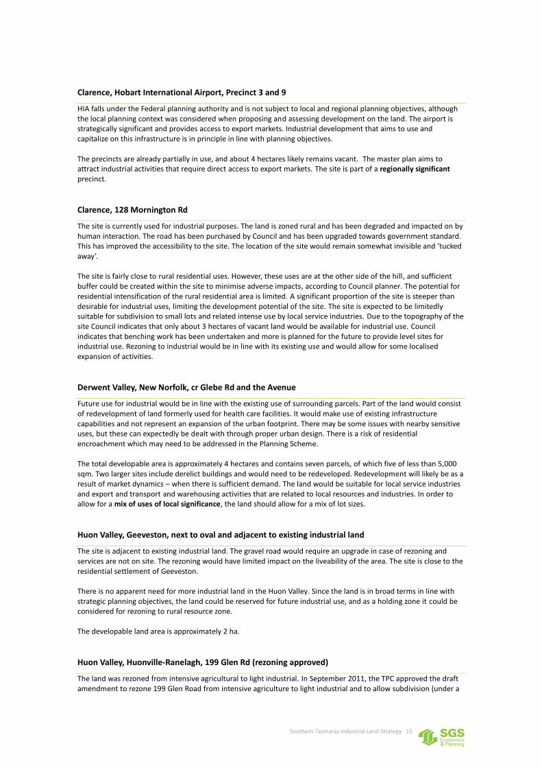
Clarence, Hobart International Airport, Precinct 3 and 9
HIA falls under the Federal planning authority and is not subject to local and regional planning objectives, although the local planning context was considered when proposing and assessing development on the land. The airport is strategically significant and provides access to export markets. Industrial development that aims to use and capitalize on this infrastructure is in principle in line with planning objectives. The precincts are already partially in use, and about 4 hectares likely remains vacant. The master plan aims to attract industrial activities that require direct access to export markets. The site is part of a regionally significant precinct.
Clarence, 128 Mornington Rd
The site is currently used for industrial purposes. The land is zoned rural and has been degraded and impacted on by human interaction. The road has been purchased by Council and has been upgraded towards government standard. This has improved the accessibility to the site. The location of the site would remain somewhat invisible and ‘tucked away’. The site is fairly close to rural residential uses. However, these uses are at the other side of the hill, and sufficient buffer could be created within the site to minimise adverse impacts, according to Council planner. The potential for residential intensification of the rural residential area is limited. A significant proportion of the site is steeper than desirable for industrial uses, limiting the development potential of the site. The site is expected to be limitedly suitable for subdivision to small lots and related intense use by local service industries. Due to the topography of the site Council indicates that only about 3 hectares of vacant land would be available for industrial use. Council indicates that benching work has been undertaken and more is planned for the future to provide level sites for industrial use. Rezoning to industrial would be in line with its existing use and would allow for some localised expansion of activities.
Derwent Valley, New Norfolk, cr Glebe Rd and the Avenue
Future use for industrial would be in line with the existing use of surrounding parcels. Part of the land would consist of redevelopment of land formerly used for health care facilities. It would make use of existing infrastructure capabilities and not represent an expansion of the urban footprint. There may be some issues with nearby sensitive uses, but these can expectedly be dealt with through proper urban design. There is a risk of residential encroachment which may need to be addressed in the Planning Scheme. The total developable area is approximately 4 hectares and contains seven parcels, of which five of less than 5,000 sqm. Two larger sites include derelict buildings and would need to be redeveloped. Redevelopment will likely be as a result of market dynamics – when there is sufficient demand. The land would be suitable for local service industries and export and transport and warehousing activities that are related to local resources and industries. In order to allow for a mix of uses of local significance, the land should allow for a mix of lot sizes.
Huon Valley, Geeveston, next to oval and adjacent to existing industrial land
The site is adjacent to existing industrial land. The gravel road would require an upgrade in case of rezoning and services are not on site. The rezoning would have limited impact on the liveability of the area. The site is close to the residential settlement of Geeveston. There is no apparent need for more industrial land in the Huon Valley. Since the land is in broad terms in line with strategic planning objectives, the land could be reserved for future industrial use, and as a holding zone it could be considered for rezoning to rural resource zone. The developable land area is approximately 2 ha.
Huon Valley, Huonville-Ranelagh, 199 Glen Rd (rezoning approved)
The land was rezoned from intensive agricultural to light industrial. In September 2011, the TPC approved the draft amendment to rezone 199 Glen Road from intensive agriculture to light industrial and to allow subdivision (under a

Southern Tasmania Industrial Land Strategy 16
specified departure clause). The quarry is largely exhausted, which makes it available for alternative use. The site is close to existing developed areas and close to Huonville CBD and supports a less dispersed development pattern. Due to its proximity to town, it would provide fairly easy access for most. The rezoning of the site is supported by local strategic planning directions and by the Huonville/Ranelagh Structure Plan. Council estimates about 13 ha of 20 ha is suitable for development. The minimum lot size is 1,000 sqm, and the use classes largely comprise local service industries but also allow for general industries and rural industries. Access onto the Huon Highway is via Glen Rd, which is sealed and wide to allow for trucks. Other industrial uses from that road include a local saw mill and timber yard and a Tassal processing plant. The wider area is also recognised in the Huonville / Ranelagh Structure Plan as having potential for downstream processing of agricultural and horticultural products. The site is suitable to be developed as a locally significant site for a mix local service industries and resource related export oriented and transport and warehousing industries.
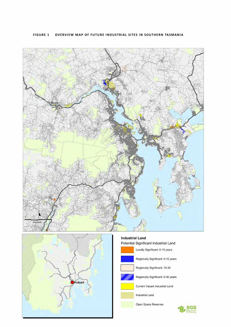
Kingborough, Huntingfield – Maddocks Road
The site is within the urban growth boundary for Greenfield development. Industrial zoning would compete with demand for land for residential and commercial purposes, but the total land area would likely allow for mixed uses. It is currently zoned primary industries. The optimal mix and intensity of uses will be subject to future site investigations. It has good access to the Channel Hwy, possibly onto bypass roundabout near Antarctic Division. The land is zoned Primary Industries and Council aims to zone it Particular Purpose Urban Growth Zone under the new planning scheme, which in principle allows for residential, commercial and/or industrial use. It would be a ‘holding zone’ for future growth. Up to 16 hectares of the total land area of 54 ha would possibly be available for industrial use. The land is being reserved by Council for future urban growth, and could therefore become available for development in the medium to long term (15 to 30 years). The site would be regionally significant (servicing the southern part of Greater Hobart) and would ideally accommodate a mix of local service industries, export oriented industries and transport and warehousing. The area would require a structure plan or area development plan to plan for its future use and to determine any appropriate industrial zoning for part of the site, and how this could be feasible without adverse impacts on sensitive uses.
3.4 Overview
There are two key sites that could accommodate a significant share of the projected shortfall of industrial land for the next 15 to 30 years:
1. The Brighton Transport Hub south, south-west site which covers approximately 82 ha of land which is already zoned industrial but still used for agricultural purposes or owned by DIER and likely to be disposed of so it can be developed for industrial use; and
2. 51 Cranston Parade in Cambridge (Clarence) which covers approximately 70 ha of developable land and for which a development application is being prepared by the owner. The site is within the Airport Buffer Overlay which is regarded as unsuitable for residential development due to airport noise impacts.
Adjacent to 51 Cranston Parade is more land that was suggested by Council for consideration. This site covers approximately 25 ha of developable land within the Airport Buffer Overlay. Another significant site for consideration (Huntingfield - Maddocks Rd) is located in Kingston and is close to the Kingston bypass roundabout near the Antarctic Division. Council is holding this land for future urban development and may involve (a mixture of) residential, commercial and industrial development. Early 2012 the Tasmanian Planning Commission approved the industrial rezoning of land on Glen Rd (Huonville-Ranelagh) of which about 13 ha is developable for industrial purposes. Both Clarence and Brighton are expected to play crucial roles in providing additional industrial land in the medium to long term (Table 5). These potential future sites will potentially provide up to 241 hectares of additional industrial

Southern Tasmania Industrial Land Strategy 17
land. The net additional demand for industrial land is projected to be between 34 and 88 hectares. The identified sites are in principle sufficient to meet demand over the next 15 years.
TA B L E 5 P OTE N TI A L FUTUR E S UP PLY OF I N D US TR I AL L A N D, BY C OUN CI L
Council area where options are located
Total area of potential future sites
Area as share of total potential future supply in Southern Tasmania
Brighton 98 41%
Clarence 108 44%
Derwent Valley 4 2%
Huon Valley 15 6%
Kingborough 16 7%
TOTAL 241 100%
The net additional demand for industrial land in the medium term (2026 to 2041) is between 153 and 238 hectares. Depending on how strong the economy develops and the population grows, the identified sites as mentioned above may not be sufficient to meet the long term demand. This means in the long term the potential future sites along Tea Tree Rd (Pontville, Brighton) or Leslie Vale (Kingborough) may need to be reconsidered, if no better alternatives are found in the meantime. Of the two sites, the Tea Tree Rd site is better positioned to a main transport corridor, close to a population centre and more easily serviced and would therefore be preferred over the Leslie Vale site. Also, potential future urban redevelopment opportunities may further impact on demand for Greenfield land.
TA B L E 6 P OTE N TI A L FUTUR E SI T E S, BY S IG NI F I CA N C E A N D IN D US TRY FOC US
Significance Site name Industry focus Land area (ha)
Regionally significant Brighton, Transport Hub west, south-west T&W, related EOI 82
Brighton-Bridgewater, north to Hub T&W, related EOI 4.3 Brighton Transport Hub Infill Opportunities T&W, related EOI 4.6 Clarence, Cambridge, 51 Cranston Parade EOI, related T&W,
Antarctic industries 70
Clarence, Cambridge, Cranston Parade (ex 51) EOI, related T&W 25
Clarence, HIA, Precinct 3 and 9 EOI, related T&W 4
Kingborough, Huntingfield – Maddocks Rd Mixed uses 16
SUBTOTAL 206
Locally significant Brighton, Bridgewater Cove Hill LSI 7
Clarence, Cambridge, 1 Kennedy Drive LSI 6
Clarence, 128 Mornington Rd LSI 3
Derwent Valley, New Norfolk Mixed uses 4
Huon Valley, Huonville, Glen Road Mixed uses 13
SUBTOTAL 30
Long term holding Brighton, Pontville, Tea Tree Rd n/a 150?
Kingborough, Leslie Vale n/a 40?
SUBTOTAL 193

Southern Tasmania Industrial Land Strategy 18
4 INDUSTRIAL LAND USE STRATEGY
This section presents the industrial land strategy for Southern Tasmania over the next 15 to 30 years.
4.1 Objective
The overall objective of the industrial land use strategy is:
To plan for sufficient industrial land in Southern Tasmania to accommodate future economic growth and to allow for sustainable urban growth patterns, for the next 15 to 30 years.
The task is to identify 34 to 88 hectares of additional (to existing vacant, suitable land) land for industrial use for the medium term (0-15 years), or to 2026. The strategy will plan for the high demand scenario (88 hectares) initially. The task is further to identify sites for long term future development (15 to 30 years from now). In the medium to long term, 2026 to 2041, the projected need for net additional land is between 153 and 238 hectares. The overall objective implies there should not be too little supply of land, which would drive land prices up and adversely impact on economic growth. It also implies there should not be too much supply of land as this can lead to unsustainable land use patterns: underuse of land, urban sprawl and establishment of uneconomic industries. In general, regional land use strategies aiming to provide for sufficient industrial land aim5 to have about 15 years of supply zoned industrial, and to have up to about 25 years of land designated for future development. This strategy has adopted a 30 year timeframe. Periodic monitoring of the take-up and availability of industrial land will be required to review this strategy. As a result of the actual future take-up of land, this target may need to be adjusted. In case of even higher demand, sites identified for development in the 15 to 30 year horizon may need to be considered for the 0 to 15 year horizon. In case of lower demand, the development of sites identified for the 15 to 30 year horizon may need to be postponed. The future demand for Greenfield industrial land may be impacted by better use and redevelopment of existing industrial land, redevelopment of industrial land to alternative uses and/or by closure of significant industrial complexes. The periodic monitoring and review that is proposed as part of this strategy will ensure these aspects will be considered, and that the industrial land strategy will be amended accordingly.
4.2 Overview of Future Industrial Sites
The map on the following page shows the future industrial sites for Southern Tasmania. More detailed maps with supporting descriptions are provided in Section4.6.
5 Productivity Commission (2011), Performance Benchmarking of Australian Business Regulation: Planning, Zoning and
Development Assessments
Southern Tasmania Industrial Land Strategy 19
F I G UR E 1 OV E RV I E W M A P OF FUTU R E I N D US TR IA L SI TE S I N S OUTHE R N TA S M AN I A

Southern Tasmania Industrial Land Strategy 20
4.3 Strategy Scope
To plan for the supply of sufficient suitable vacant industrial land, the following measures are available:
Zoning of land, codes and specific area plans
Setting conditions to manage the intended use or development of the land in line with strategic considerations (such as minimal lot size, urban design criteria, access requirements)
Actively managing regional land use and development, for instance by a land development agency The first two points can be achieved by an industrial land use strategy for the region that is endorsed and adopted by participating councils and local planning schemes. The third dot point relates to a more active and regionally concerted approach to land use planning where a separate government body such as a land development agency would play a central role in purchasing land, developing it and releasing it to the market according to a sequenced approach. The objective of this strategy is to provide for industrial land over the next 15 to 30 years. The scope of the strategy does not include the identification of possible redevelopment sites and any measures to achieve better use of existing land. However, the two are interrelated. Redevelopment of land may impact on land availability and therefore impact on demand for net additional land. In fact, a theoretical data exercise undertaken in the first stage of this study suggests underutilisation of industrial land may be a key issue in Southern Tasmania, especially in long established industrial areas such as in Glenorchy. There is a need to properly investigate the apparent underutilisation of industrial land in established urban areas, and to form a strategic approach to improve land use in these areas for Greater Hobart. Non-conforming uses, fragmented land ownership and historical urban growth patterns are causes of inefficient land use. If better use of existing land can be achieved, there may be less demand for Greenfield land. Vice versa, an oversupply of Greenfield sites discourages redevelopment of derelict and underused sites. Measures for better use of existing industrial land include:
Prevention of non-conforming uses through planning schemes
Management of regional supply of land (in case of an oversupply of Greenfield land, potential redevelopment sites are less attractive)
Active management of redevelopment of existing derelict and/or underused sites (amalgamating fragmented land, purchasing, redeveloping and selling land), by a government-owned land organisation (GLO)
While the first point can be addressed through succinct planning schemes6, the two latter points require a more active and regionally concerted approach. Redevelopment of areas generally requires the support of a land development agency, or government-owned land organisation, to purchase and amalgamate land, to redevelop the areas and to then release (sell) the land according to a strategic and sequenced approach. If in the future a strategy to improve land use efficiency is adopted, such a strategy would achieve results in the medium to long term (say 5 to 15 years from now) at best. The results may impact on the net additional demand for industrial land over time. So, by that time there may be a need to review this Industrial Land Strategy in light of realistic targets to make better use of existing industrial land. Tasmania is the only state in Australia that does not have a government-owned land organisation (GLO) that acts as a developer. A GLO can guide Greenfield land release and to redevelop existing urban areas. Although GLOs have the capacity to complete developments on their own, they often partner with private sector developers to complete projects (PC, 2011). In the absence of that, the available measures for land use planning of industrial land is mainly confined to rezoning of land and setting planning conditions. Appendix 2 provides a quick overview of the operations of government-owned land organisations in Australia. From a property development perspective, any barriers or constraints to invest and develop may defer the release of serviced and newly developed industrial land. Also, any incentives to support property development may speed up the release of serviced and newly developed land. The level of red and green tape sometimes generates significant
6 This has mostly been achieved already; most current non-conforming uses are a result of more historic planning decisions and
planning conditions.

Southern Tasmania Industrial Land Strategy 21
additional costs to developers to meet conditions and for local government authorities in terms of costs of regulation. The costs of additional regulation should in general be outweighed by the benefits. Barriers and incentives to property development have not been considered to any level of detail as part of this study. As a rule of thumb, the costs of implementing and applying regulation, subsidies, development charges and other constraints and incentives should be outweighed by the wider benefits. Benefits would not only relate to monetary values, but also social, environmental and other less tangible values. A broader study into development constraints and incentives that considers all land zonings and uses may provide a solid background of relevance for future industrial development.
4.4 Measures to Manage Industrial Land Availability
Within the existing planning framework, planning authorities have a number of measures available to influence and manage land supply and the way land supply meets demand characteristics. This strategy makes recommendations using some of these measures including minimum and maximum lot sizes and the need to implement structure plans at some of the key sites of strategic importance. In addition to the recommendations in this strategy, local planning authorities may want to consider the application of additional conditions to permits derived from their local planning scheme zone objectives. Below follows an overview of the generic measures that are available in Tasmania at present.
Special provisions
Special provisions for certain types of use or development are not specific to any zone, area plan, or an area to which a code applies. Currently the Special provisions in the Template relate to changes to existing non-conforming uses, adjustments of boundaries and demolition. Additional special provisions could be made that apply to all use or development.
Land Zoning
Under the new planning scheme format the following zones are designated for industrial land use:
Light Industrial Zone which provides for manufacturing, processing, repair, storage and distribution of goods and materials where off-site impacts are minimal or can be managed to minimize conflict or impact on the amenity of any other uses.
General Industrial Zone which provides for manufacturing, processing, repair, storage and distribution of goods and materials where there may be impacts on neighbouring uses.
Other zones that may accommodate some industrial uses are:
Rural Resource Zone which provides for: o the sustainable use or development of resources for agriculture, aquaculture, forestry, mining
and other primary industries, including opportunities for resource processing; or o other use or development that does not constrain or conflict with resource development uses.
Port and Marine Zone which provides for port and marine activity related to shipping and other associated transport facilities and supply and storage..
Particular Purpose Zone which provides for use with a particular purpose defined by the relevant planning authority.
Codes (Subclause 7.1 of the Planning Directive)
Codes set out standards for use or development for matters that are not confined to one zone and apply over and above zone provisions. Where there is a conflict, codes provisions override zone provisions but specific area plan provisions override code and zone provisions. A code should not alter the intent of the zone and should assist in delivering appropriate planning outcomes.

Southern Tasmania Industrial Land Strategy 22
Specific area plans (Subclause 7.2 of the Planning Directive)
Specific area plans can comprise of local area plans, structure plans or development plans. They are used to implement more detailed planning controls and apply in addition to the underlying zone or overlying code. Where there is a conflict, the provisions of specific area plans override zone and code provisions.
Use and development standards
Standards are requirements that must be addressed by the particular use of development of land and are provide as a section of a zone, code or specific area plan. Use standards relate to the on-going operation or performance of a use and include requirements in regards to:
Hours of operation
Size and type of machinery
Noise, air and light emissions
Outdoor storage and public display The conditions may be attached to a permit. Development standards relate to built structures and the subdivision or consolidation of land, and include:
Lot dimensions
Height and setbacks
Density and site coverage
Public and private open space
4.5 Sequencing and Timing Considerations
Meeting the projected shortfall over the next 15 years There are two significant sites that could meet most of or the entire target of 34 to 88 hectares industrial land in Greater Hobart for transport and warehousing and export oriented industries over the next 15 years. These sites are the already industrial zoned land to the west south-west of the Brighton transport hub (approximately 82 hectares of vacant land) and the proposed site at 51 Cranston Parade (approximately 70 hectares of land). The strategic focus of the two areas differs somewhat. The site south, south-west of the transport hub would logically be transport and warehousing oriented, with a focus on rail and road transport and both inbound and outbound transport activities with related export oriented industries. The site adjacent to the airport would be more export oriented, supported by warehousing, with a short delivery line to the airport.

Southern Tasmania Industrial Land Strategy 23
Anecdotal evidence suggests a few land owners hold the majority of vacant land in ownership. The Productivity Commission recently published data that show that industrial land prices in Greater Hobart have increased quite sharply in recent times. The figure below (Figure 2) shows a significant drop in land sales (and also a shift towards smaller lots) and a simultaneous significant increase in land prices. This effect may occur due to either an undersupply of land or an ‘artificial’ undersupply of land, where existing supply is not made available to the market. Land data analysis has shown there is no acute shortage or undersupply of industrial land in the short term. Also, the land prices continued to increase in an economically weakening period.
F I G UR E 2 G R EATE R HOBA R T SA LE S & P R IC E S OF IN D US TR IA L LA N D, 2 0 05 - 0 6 TO 2 00 9 - 1 0
Source: Productivity Commission (2011) To adequately support economic growth in Southern Tasmania, it is important there is sufficient industrial land providing for a range of types, sizes and locations. It is therefore recommended to allow for industrial development at the two locations of strategic regional significance in Brighton (south, south-west to the transport hub) and in Clarence (51 Cranston Parade) and to stage or sequence the development of these sites according to forecast demand. By allowing both sites to be partially developed over the next 15 years, the risk of undersupply of land (artificial or not) is reduced. For the regionally significant sites it is recommended:
To identify both the site south, south-west to the Brighton transport hub and the 51 Cranston Parade site as regionally significant industrial sites with relevance to the short to medium term supply (0-15 years) and medium to long term supply (15 to 30 years) of regionally significant industrial land.
To identify the site south, south-west to the Brighton transport hub as a site oriented towards transport and warehousing, requiring proper truck access to sites and medium to large lots.
To identify the 51 Cranston Parade as a site oriented towards export industries and supporting warehousing with strong linkages to the airport, and requiring a mix of medium and large lots. In case an activity on the air bridge between HIA and the Antarctic grows substantially, the site should also be identified as a site to accommodate industries related to the Antarctic. Note: the technical assessments of 51 Cranston Parade need to be reviewed to confirm the suitability and feasibility of the site.
To release these sites according to a staged approach, by allowing approximately half of the area of the sites being subdivided within the next 15 years. The remainder is to be held in large lot sizes;
To reserve the remainder by allowing subdivision of the remaining land in the longer term only (15 to 30 years from now) or on the basis of a review of the industrial land use strategy or a demonstrated need for more industrial land. This land is to be included in the next iteration of the Regional Land Use Strategy and reserved as potential long term industrial land.
To develop a structure plan (or local area plan) for both the Brighton transport hub and the 51 Cranston Parade sites. These plans need to prescribe that at least half of the developable land area of these sites is

Southern Tasmania Industrial Land Strategy 24
to be reserved for large lot sizes until 15 years from now or if it can be demonstrated there is an unmet need for smaller lot sizes that cannot be accommodated at other nearby industrial sites.
To allow the development of the infill sites and the site north and adjacent to the Hub in Brighton for industrial use. Lot sizes should be adequate to accommodate transport and warehousing and export oriented industries.
The Antarctic Gateway principle is an important economic development principle for Southern Tasmania. An established passenger air bridge between HIA and the Antarctic (not currently present) would be a key element of this development opportunity. The Cranston Prde site would be strategically well located to accommodate services and industries related to Antarctic operations. The type of associated uses and their typical footprints and other use and operational aspects may require specific allowances in the structure plan for this precinct. The structure plan should clearly demonstrate the likelihood of an established passenger air bridge with the Antarctic and the requirements for Antarctic related industries and how this translates to lot sizes, use and operational standards. Also, the structure plan should provide for measures, use and operational requirements that prevent local service industries from occupying this regionally significant precinct.
In addition to industrial land of regional significance, there should also be sufficient land to accommodate demand from local service industries. In regards to local service industries, it is at the discretion of individual to plan for industrial zoned land. This strategy provides considerations for Councils in relation to their strategic industrial land use planning. In Clarence, there is sufficient industrial land in general, but a lack of small sites of below 2,000 sqm. A variation to a recent approval for subdivision aims to create just over 70 lots, with about 56 lots for general industrial uses with lot sizes ranging from 1,800 sqm to 7,000 sqm in the Cambridge area. More small lots are likely required within the 15 year timeframe. Part of the site at 1 Kennedy Drive would be well suited to accommodate demand for local service industries, including potential ‘over flow’ demand from Hobart and Glenorchy7. If to be developed within the next 15 years, this site should be required to provide small lots primarily (maximum lot size of about 3,500 sqm). In Brighton, to provide for local service industries and some possible ‘over flow’ demand from Glenorchy, the Cove Hill area should be made available to accommodate local service industries specifically. The area has already attracted a significant number of small scale industries, in quite a similar way as the area in Southern Brighton that is proposed to be zoned industrial to reflect and accommodate existing uses. A possible socio-economic benefit would be the local job creation in an area where unemployment rates are significant. In Kingborough, no potential new sites for industrial zoning within the short to medium term were identified. The Huntingfield – Maddocks Rd property is unlikely to be developed within five to ten years. Council has earmarked this site for future urban growth. A temporary shortage of industrial land for mixed industrial uses may occur in Kingborough. Better use of existing land may help bridge this temporary gap, until land at Huntingfield – Maddocks Rd is being developed. Outside Greater Hobart, additional potentially suitable sites of local significance have been identified in New Norfolk, Huonville and Geeveston8. The New Norfolk site represents an opportunity for redevelopment of derelict land. The site in Huonville has been approved in 2011 and provides land for local service industries and possibly some export oriented industries and transport and warehousing. The site would provide sufficient land to meet demand for the next 30 years. The site at Geeveston could be considered in the long term, and may in the meantime be rezoned to rural resource zone as a holding zone. In the short to medium term the following locally significant sites should be considered to be rezoned to industry:
Brighton, Cove Hill – the area that is currently zoned commercial, to accommodate local service industries (7 ha.)
Clarence, part of 1 Kennedy Drive, to accommodate local service industries (approximately 6 ha.)
Clarence, 128 Mornington Rd, to enhance conformity of use and allow for some expansion of industrial uses (approximately 3 ha.)
Derwent Valley, New Norfolk, corner of Glebe St and the Avenue, to accommodate a mix of local service industries, export oriented industries and transport and warehousing (4 ha.)
Huon Valley, Huonville, Glen Road (rezoning already approved), to accommodate a mix of local service industries, export oriented industries and transport and warehousing (13 ha.)
7 The option at 128 Mornington Rd is little suitable for industrial use, and especially for local service industries. 8 No other shortfalls were identified in Southern Tasmania

Southern Tasmania Industrial Land Strategy 25
In total these locally significant sites for local service industries add up to approximately 30 hectares of developable land. Meeting future demand for industrial land, 2026 to 2041 In the longer term, 15 to 30 years from now, the remainder of the sites south, south-west of the Hub and 51 Cranston Parade are recommended to be rezoned (if applicable) and subdivided. Over this longer term period, the following sites may also be rezoned and developed for industrial use, depending on specific site assessments:
Cranston Parade site adjacent to 51 Cranston Parade in Clarence (~25 hectares)
Huntingfield – Maddocks Rd property in Kingston (up to 16 hectares) Depending on the growth rate of the economy and of the population in Southern Tasmania, additional future sites may need to be considered. By that time, and if no suitable alternatives are found, it would be recommended to consider the land identified off Tea Tree Rd in Pontville (Brighton) for future industrial use. The site would need to be assessed in more detail. Potential constraints include its current agricultural zoning, nearby residential uses, heritage and natural conservation values. Since the site is that large, there would presumably be sufficient opportunities to create buffers and to reserve areas for conservation offsets. It is recommended to identify the Tea Tree Rd site in the future iteration of the Regional Land Use Strategy mapping as a potential long term future site for industrial growth (15 to 30 years from now).The current rural resource zone could remain in the meantime. The Leslie Vale site is less suitable as a regionally significant site than the Tea Tree Rd site. It is less strategically located towards the south of Hobart, and there are no infrastructure and services provided or nearby. However, if the site assessments at Tea Tree Rd identify constraints that inhibit future industrial use, this site may still be considered. The Leslie Vale site could be reserved for long term future use (30+ years). The current zoning (Primary industries) would be appropriate to reserve the land for potential future industrial use. These sites should be included in the next iteration of the Regional land Use Strategy and reserved as potential long term industrial land.

Southern Tasmania Industrial Land Strategy 26
4.6 Overview and Maps
The table below indicates how the unmet demand for industrial land over the medium term (to 2026) and long term (to 2041) would be met by future industrial sites.
TA B L E 7 I N D US TRI AL L AN D TO 2 0 26 AN D 2 0 4 1
Future sites Site names
Land area
To meet projected shortfalls for
Regionally significant sites, for the short to medium term, to 2026
- 50% south-west Hub, Brighton 41 ha
- Infill Brighton, Brighton 9 ha
- 50% 51 Cranston Pd, Clarence 35 ha
- Hobart Airport (HIA), Clarence 4 ha
Sub-Total 89 ha 34-88 ha
Regionally significant sites, for the medium to long term, 2026 to 2041
- 50% south-west Hub, Brighton 41 ha
- 50% 51 Cranston Pd, Clarence 35 ha
- Cranston Pd, Clarence 25 ha
- Huntingfield–Maddocks Rd, Kingb. 16 ha
For consideration: Tea Tree Rd, Pontville 150 ha
Sub-total 267 ha 153-238 ha
Locally significant sites, to meet local shortfalls for the short to long term (to 2041)
Cove Hill, Brighton 7 ha
1 Kennedy Dr, Clarence 6 ha
128 Mornington Rd 3 ha
Glebe Rd/Avenue, New Norfolk 4 ha
190 Glen Rd, Huonville 13 ha
Sub-total 33 ha Local shortfalls
Total 389 ha 187 – 326 ha Source: SGS (2012)
The following maps (Figure 3 to Figure 9) show the potential future sites and indicate the significance (locally or regionally significant) and the timing of the envisaged release of the land. The first map focuses (Figure 3) on the Bridgewater area and Brighton Transport hub. There are three identified options that would be part of the Brighton Transport Hub which is an industrial estate of regional significance and still well in development. The three options are:
Brighton-Bridgewater, north adjacent to Hub
Brighton Transport Hub west, south-west
Brighton Transport Hub infill opportunities The Railyards are in the process of being relocated from Hobart to reserved land9 at the transport hub over the next couple of years. This is expected to generate additional demand for development in the area. Macquarie Point in Hobart may become a mixed use site without industrial uses. The infill sites around the hub are recommended to be released and developed within the short to medium term. The large site south-west of the hub is recommended to be gradually released and developed, about half of it over the next 15 years and the remainder in the longer term. These sites will be developed in a way that they attract transport and warehousing and related export oriented industries. Lots need to be medium to large (~3,000 sqm and above), have good access to the Midland Highway and be accessible by large trucks. The land is flat to undulating, which is suitable for transport and warehousing activities. In the Cove Hill Rd area in Bridgewater, future industrial sites are recommended to cater for local service industries. The land is recommended to cater for small lot sizes. The area has already attracted a range of local service industries and this will enable agglomeration effects attracting increasing traffic.
9 This land has not been identified as vacant in Stage 1 of the project, as it is reserved for intended uses.

Southern Tasmania Industrial Land Strategy 27
The next following map (Figure 4) provides a more distant overview of the Brighton area and also identifies the potential future site for industrial use at Tea Tree Rd. Depending on the rate of economic and population growth, and the availability of suitable alternatives, this site may need to be considered in the long to very long term. Until that time, this land is identified as a potential future site for urban growth.
F I G UR E 3 B R IG HTON -B R I DG E WATER TRA N S P OR T HUB A N D C OV E HIL L A R EA

Southern Tasmania Industrial Land Strategy 28
F I G UR E 4 B R IG HTON BR I DG E WATER , I NC LUDI NG TEA TR E E R OA D

Southern Tasmania Industrial Land Strategy 29
In Clarence (Figure 5), most of the future industrial land is located in and around the Cambridge area and the Hobart International Airport (HIA). In the short to medium term, regionally significant sites at HIA and part of 51 Cranston Parade are recommended to be released and developed. From about 2026 to 2041, the remainder of 51 Cranston Parade would be developed, and depending on the rate of demand, the adjacent site also at Cranston Parade should be considered for industrial use. While there is a significant supply of vacant industrial land in Clarence, there is a shortfall of small lots to cater for local service industries to 2026. There may therefore be an opportunity, to zone part of the site at 1 Kennedy Drive and subdivide this land into small lots (up to about 3,000 sqm). The land between Tasman Highway and Kennedy Drive, referred to as Cambridge Park, has been included as a non-industrial site. The current use and development of this area is not predominantly industrial, despite the zoning in the planning scheme, and includes many commercial uses. The removal of industrial zoning from this land would not have a material impact on the future supply of vacant industrial land. It is not for this Strategy to recommend on land zonings other than industrial. In Kingborough, there is a shortfall of industrial land to cater for a mix of industrial uses. For the short to medium term, there may not be opportunities to address this shortfall. In the medium to long term however, a significant site near the Kingston bypass roundabout near the Antarctic Division may be available for future urban growth (Figure 7). Kingborough Council intends to reserve this land (referred to as the Huntingfield- Maddocks Road property) as a special particular purpose zone for future urban development. It is recommended that part of this site, up to 16 hectares, is considered for industrial use, catering for a mix of potential uses (local service industries, transport and warehousing and export oriented industries). The Kingborough map provides an indicative size, shape and location of the future industrial land within the property. The exact size and location will be determined as part of future urban planning exercises and site assessments.

Southern Tasmania Industrial Land Strategy 30
F I G UR E 5 C L A R EN C E
* Specialty industrial use: Commonwealth land, which is beyond the jurisdiction of State and local planning controls.

Southern Tasmania Industrial Land Strategy 31
F I G UR E 6 C L A R EN C E , M ORN IN GTON
Southern Tasmania Industrial Land Strategy 32
F I G UR E 7 K I NG B OR OUG H

Southern Tasmania Industrial Land Strategy 33
In the regional areas of the Huon Valley and the Derwent Valley, the economic centres of Huonville and New Norfolk are recommended to cater for industrial land for a mix of industries; local service industries and transport and warehousing and export oriented industries that are predominantly related to local resources and agricultural production. In Huonville, a proposed rezoning has been approved for an industrial site between Huonville and Ranelagh (Figure 8). The site is close to an existing aquaculture processing plant. The area around the plant has been earmarked for downstream processing of regional produce and resources. In New Norfolk, Council aims to rezone land adjacent to the centre of New Norfolk to industrial (Figure 9). These two sites are expected to accommodate demand for land over the short to long term. The site is part of the previous health precinct which has been abandoned and is in a derelict state. Rezoning and redeveloping the site is a strategic planning opportunity. There is a risk of sensitive uses encroaching the area thereby increasing the risk of land use conflict. It is recommended for Council to address this appropriately and maintain sufficient buffer.

Southern Tasmania Industrial Land Strategy 34
F I G UR E 8 HUON V I L L E

Southern Tasmania Industrial Land Strategy 35
F I G UR E 9 N E W N OR FOL K

Southern Tasmania Industrial Land Strategy 36
4.7 Conditions for Regionally Significant Sites
While it is important to determine the strategic direction of regionally significant sites, being too prescriptive may inhibit the development of the land and economic growth in general. As was recently noted by the Productivity Commission, industrial land uses across cities are far more varied than residential and commercial uses. Hence, there is far greater variation required. This strategy does therefore not aim to provide precise requirements in regards to for instance road frontage, lot depth, use restrictions etcetera. This strategy does aim to provide sufficient guidance to ensure sufficient industrial land is planned for, and that the land is broadly suitable for the intended use categories: local service industries, export oriented industries, transport and warehousing or a mix of these. Local planning authorities may add conditions to ensure local planning issues are being considered.
Minimum and maximum lot sizes
A key denominator between local service industries and export and transport & warehousing, is the common lot size. Local service industries tend to use lots with a size up to 2,000 sqm mostly, with some uses requiring lots of between 3,000 and 4,000 sqm. Transport and warehousing and export oriented industries tend to occupy land of 3,000 sqm and up. In order to guide the intended use of sites, it is recommended for Councils to:
Apply a maximum lot size of about 3,500 sqm for local service industries, and
Apply a minimum lot size of about 2,500 sqm for regionally significant sites, that accommodate export oriented industries and transport and warehousing.
Occasionally, there is demand for very large industrial sites of more than 10 or 20 hectares.
The intended use of regionally significant sites
The two strategic sites south-west to the Hub in Brighton and 51 Cranston Parade in Clarence will accommodate a significant amount of industries over the next 15 to 30 years. To ensure the two sites fulfil their significant roles in providing for regionally significant land, there should be due consideration of how these sites relate and connect to their surrounding areas. It is recommended to develop local area or structure plans for both areas. While structure plans are generally drawn up for residential and mixed use areas, the regionally strategic significance of the two sites requires that they are developed sensibly and with regard to their surroundings. The structure plan for the south-west to the Hub site would consider most of the Brighton transport hub and surrounding industrial uses. The structure plan for Cranston Parade would include both 51 Cranston Parade and the adjacent site and the connectivity to HIA and the Tasman Highway. The structure plans will at least need to address:
Transport connectivity; traffic flow, road width and design and logistics are key considerations for the southwest hub site, and the connection to the HIA and Midlands Hwy is a key issue for the Cranston Parade sites
Operating hours; 24/7 operating hours is a key requirement for transport and warehousing activities and therefore the southwest hub site in Brighton. For the Cranston Parade site operating hours may be considered in relation to the Airport Buffer Overlay10 and possible nuisance for nearby residential uses
An appropriate mix of lot sizes. Export oriented industries mostly operate from medium sized lots of between 3,000 sqm and 2 hectares. Transport & warehousing activities operate from a mix of lot sizes. Based on the existing mix of transport & warehousing uses in Greater Hobart, the precinct area would provide a mix of sites of
o ~2,500 sqm to 1.5 ha – covering roughly 35% of the total area; o 1.5 to 4 ha – covering roughly 20% of the total area; o 4 to 8 ha – covering roughly 30% of the total area, and o Larger sites – covering roughly 15% of the sites.
Other issues may be addressed in the local area or structure plans at the discretion of the responsible municipality, such as urban design and sustainability principles.
10
Flights and noise from the airport is mostly restricted to between 6am and 12pm

Southern Tasmania Industrial Land Strategy 37
Staging of Land Development
Land at potential future sites may be allowed to be rezoned in line with the intended development horizon of the sites demonstrated in the maps. However, there are no planning instruments available to control the timing of land release and development of land if it is already zoned industrial, or if sites are intended to be developed according to a staged approach. The local area or structure plans for the southwest hub site and the 51 Cranston Parade site will need to describe the intended rate of development of the land. In order to provide some guidance both the south-west hub site and the 51 Cranston Parade are required to reserve a significant share of land for potentially very large uses (requiring 10, 20 hectares or more) for the next 15 years or until it can be demonstrated that there is an unmet demand for industrial land for smaller lot sizes, and that this unmet demand cannot be met by alternative suitable locations. The Cranston Prde precinct will be well positioned to accommodate Antarctic related industries. The local area or structure plan should allow for appropriate lot sizes and other guidelines to accommodate Antarctic industries based on demonstrated evidence of the particular needs of these industries. The local area or structure plan should also include requirements to ensure the land is occupied by a range of intended uses complimentary to the functions of the airport (i.e. export oriented, Antarctic industries and transport and warehousing). For the southwest hub site, approximately 40 hectares would need to be reserved for potential demand for large industrial sites of 10 hectares or more. For the 51 Cranston Parade site, approximately 35 hectares (or 50% of developable area) would need to be reserved for demand for large industrial sites of 10 hectares or more. It is further intended that the site adjacent to 51 Cranston is developed after that site has been largely taken up. Therefore this strategy determines that the rezoning and development of the site adjacent to 51 Cranston Parade, which would expectedly occur in the medium to long term (between 2026 and 2041), would be allowed if it can be demonstrated there is an unmet demand for industrial land which cannot be met at alternative suitable locations (most importantly 51 Cranston Parade).

Southern Tasmania Industrial Land Strategy 38
4.8 Monitoring and Review
Monitoring is required to understand the actual take-up of vacant industrial land and the rezoning of land to or from industrial. This data could be collected on a bi-annual basis, or at least once every five years. The analysis of the monitoring data will demonstrate:
How much land is taken up
Where land is taken up
What lot sizes are taken up and developed
How much land is being rezoned
Any changes in the land price of industrial land On the basis of this analysis, the industrial land strategy may need to be reviewed. A lower or higher than expected take-up rate of land may require a reconsideration of the timeframes for future industrial sites. Also, it may be possible that in the future measures will be implemented by planning authorities to support land redevelopment into alternative uses, infill development and better or more efficient use of industrial land. The possible future closure of a significant industrial complex could provide land for other industries to locate there. As part of that, it may be required to adjust the timeframes for Greenfield land release either by:
Minimising new land release as an incentive to make better use of existing industrial land (note that this measure should only be adopted if effective measures to enable better use of land are available);
Adjusting the timing of future industrial sites to reflect the expected drop in demand for Greenfield sites as a result of better use of existing land (allowing more industrial uses being accommodated on existing industrial land)
The data requirements for monitoring encompass the following:
Uptake of vacant land by location (Council, Precinct/Suburb): o Number of parcels o Land area o Date of development application o Type of use
Supply of vacant and suitable industrial land by location: o Number of parcels o Land area
Rezoning of land to industrial and vice versa by location: o Number of parcels o Land area o Date of approval
Trends in industrial land price data: o Number of lots and area sold per annum o Mean and median land price per annum ($/sqm or $/ha)
Redevelopment projects involving industrial land (to make better use of existing land) or land that may be rezoned to industrial land.
o Number of parcels o Land area o Expected improvement of the use of the land
Further, there is a need to properly investigate the apparent underutilisation of industrial land in established urban areas, and to form a strategic approach to improve land use in these areas for Greater Hobart.

Southern Tasmania Industrial Land Strategy 39
A P P E N D I X 1 F I RS T S TE P OP TI ON A S SE S S ME N T – FAC T S HE E TS
The long list of future options is as follows:
Brighton, Bridgewater Cove Hill, 10 vacant lots on current commercial precinct, considered to be rezoned
to light industrial, Hurst St, Cove Hill Rd and Cowle Rd, developable area 10 ha.
Brighton, Brighton-Bridgewater, seven lots adjacent to existing Brighton Industrial Estate, adjacent and
close to Midland Hwy11
.
Brighton, Pontville, 367, 447 and 503 Tea Tree Road, approximately 150 ha.
Brighton, Transport Hub west, south-west, Industrial land with current agricultural, Cobbs Hill Rd.
Brighton Transport Hub Infill Opportunities, Industrial parcels 85916/1, 9559/3, 50018/4 and 163537/1.
Clarence, Cambridge, 51 Cranston Parade, developable area approx. 70 ha.
Clarence, Cambridge, Cranston Parade (excluding 51 Cranston Prde), developable area approximately 25
ha, subject to site assessments
Clarence, Cambridge, 1 Kennedy Drive, land zoned intensive agriculture.
Clarence, Hobart International Airport, Precinct 3 and 9, land is partly in use, remaining vacant area is well
below than 15.5 ha. (Which is total area).
Clarence, HIAPL land identified for potential future aeronautical services, land is vacant and adjacent to
airport, area is approximately 35.6 ha
Clarence, Mornington, three lots comprising existing Mornington Waste Transfer Station and adjacent,
developable area less than 23.5 (total area).
Derwent Valley, New Norfolk, cr Glebe Rd and the Avenue. Developable, vacant land area is approx. 5.6
ha, proposed rezoning as part of PS review.
Glamorgan-Spring Bay, Triabunna, Part of Mount Murray, 336 Okehampton Rd, developable area yet
unknown, could be very large.
Huon Valley, Cradoc, Duggans Pty ltd quarry, Channel Hwy, developable area yet unknown.
Huon Valley, Geeveston, next to oval and adjacent to existing industrial land, Council owned, 2 to 3
hectares.
Huon Valley, Huonville, 199 Glen Road: approved rezoning to industrial. Developable area approx. 13ha.
Kingborough, Leslie Vale: HBMI Pty Ltd Quarry opposite Leslie Vale turn-off from Huon Hwy. Developable
area approx. 50 ha.
Kingborough, Kingston Huntingfield – Maddocks Rd: 27 Springfarm Rd, developable area up to ~16 ha.
For each of the identified future industrial options, the first stage was used to collate the following information to
gain a better understanding of the likely suitability of the option in broad terms:
1. Alignment with State and regional planning objectives
2. Developable land area
3. Current zoning and use
4. Land status: ownership, parcels, lot sizes, planning and management authorities
5. Availability and proximity of infrastructure and services (transport, water, sewage and power)
6. Physical site characteristics (slope, soil issues, hazards, contamination)
7. Environmental, heritage and other conservation values
8. Other planning, legislative or statutory constraints
9. Nearby uses
11
Land titles are: 2 titles unknown, 156586/10, 156586/3, 159938/4, 156586/1, 156856/11

Southern Tasmania Industrial Land Strategy 40
Site: Brighton, Bridgewater Cove Hill Address: Hurst St, Cove Hill Rd and Cowle Rd
Suburb: Bridgewater Date: 28 March 2012
1. ALIGNMENT STRATEGIC PLANNING OBJECTIVES
The vacant lots are in a wider commercial zone, which is proposed to be rezoned to industrial to better reflect the actual use of the area. One significant parcel particularly is close to an existing residential area in Bridgewater, and would require adequate buffering and planning provisions not permitting uses with significant impacts such as noise, air quality and smell.
The adjacent Bridgewater residential area is a social housing area with a high level unemployment. More industrial land would potentially create additional jobs for this community, however, a rezoning from commercial to industrial does not necessarily provide better job opportunities.
The sites are within the existing developed area and development could most likely be serviced by existing infrastructure provisions.
2. DEVELOPABLE LAND AREA
Ten lots were vacant at the time of site visit (28 March 2012). Total area comprises approximately 8 hectares, with one site comprising 5.8 ha. This lot is adjacent to residential area requiring maybe 1 ha buffer. This brings the developable area to 7 hectares.
3. CURRENT ZONING AND USE
The vacant parcels are currently zoned commercial and are currently not in use.
4. LAND STATUS (OWNERSHIP, PARCELS, LOT SIZES, PLANNING AND MANAGEMENT AUTHORITIES)
The parcels are in private ownership. Three parcels in the area of 600 sqm, 4 parcels just under 3,000 sqm and 2 parcels just over 4,000 sqm and 1 parcel of 5.8 hectares of which about 4.8 hectares would be developable. See below parcels marked with red cross.
All land falls under the Brighton Planning Scheme.
5. INFRASTRUCTURE AND SERVICES (TRANSPORT, WATER, SEWAGE, POWER, ICT)
All sites have road access. All sites would also have access to water, sewage, power and telephone/broadband. Cove Hill Rd provides easy access, also for heavier vehicles, to the Midland Hwy.
6. PHYSICAL SITE CHARACTERISTICS (SLOPE, SOIL ISSUES, HAZARDS, CONTAMINATION)
The land is relatively flat and as far as known there are no soil issues and/or hazards.
7. ENVIRONMENTAL, HERITAGE AND OTHER CONSERVATION VALUES (INCLUDING SIGNIFICANT AGRICULTURAL LAND)

Southern Tasmania Industrial Land Strategy 41
There are no known conservation values applicable to the land.
8. OTHER CONSTRAINTS
The land is close to a social housing estate. This may impact adversely on the perception of businesses located there. There may also be a (perceived) risk to security in being located there.
9. NEARBY USES
One parcel is close to a residential area of Bridgewater. Sufficient buffer would be required when developing this land. This would be true both under its current zoning and its potential future zoning as industrial. Other nearby uses are commercial/industrial.
10. OTHER OBSERVATIONS
-
Site: Brighton, Brighton-Bridgewater Address: seven lots adjacent to existing Brighton Industrial Estate, adjacent and close to Midland Hwy12
Suburb: Brighton Date: 28 March 2012
1. ALIGNMENT STRATEGIC PLANNING OBJECTIVES
The sites are all close the Brighton Transport Hub and close to the Brighton bypass. It would use land directly adjacent to a key transport corridor. The sites could in principle make use of existing infrastructure (partly still in development). There are however some significant constraints in terms of conservation values and physical aspects (see remainder).
Only one site does not contain significant natural and/or cultural heritage values (159938/4), the other sites are not available/suitable for industrial use.
2. DEVELOPABLE LAND AREA
The total area of the parcels is approximately 11 ha (see map below). The red parcels are heavily constrained. The yellow site is unconstrained.
12
Land titles are: 2 titles unknown, 156586/10, 156586/3, 159938/4, 156586/1, 156856/11

Southern Tasmania Industrial Land Strategy 42
After excluding the parcels with significant constraints, one parcel remains and has an area of 4.3 ha – see map below. The remaining six parcels have an area of about 11ha.

Southern Tasmania Industrial Land Strategy 43
3. CURRENT ZONING AND USE
Current zoning Rural. Except for one parcel (159938/4), the remaining parcels are Future Crown Reserves and future zoning would likely be Environmental Management Zone.
4. LAND STATUS (OWNERSHIP, PARCELS, LOT SIZES, PLANNING AND MANAGEMENT AUTHORITIES)
The parcels are owned by DIER. With the exception of the one parcel, the land has significant natural and cultural values. DIER has long term obligations to protect the values. The sites often contain offset areas to compensate for natural values that were within the Brighton bypass route. Parcel (159938/4) is also owned by DIER is considered (by DIER) for disposal to it can be used for industrial activity.
5. INFRASTRUCTURE AND SERVICES (TRANSPORT, WATER, SEWAGE, POWER, ICT)
The parcel without conservation values and long term protection obligations (parcel 159938/4), has good road access and is located between rail
and road infrastructure (adjacent to the Brighton Bypass). Water, sewer and electricity would be easily available.
6. PHYSICAL SITE CHARACTERISTICS (SLOPE, SOIL ISSUES, HAZARDS, CONTAMINATION)
Parcel (159938/4) is relatively flat and is not subject to any known hazards.
7. ENVIRONMENTAL, HERITAGE AND OTHER CONSERVATION VALUES (INCLUDING SIGNIFICANT AGRICULTURAL LAND)
All parcels (except parcel 159938/4) have significant heritage and natural conservation values. Also, DIER has long term obligations to protect the values. These sites are all owned by DIER and earmarked as future Crown Reserve and expected to be rezoned to Environmental Management Zone.
8. OTHER CONSTRAINTS
One parcel has no road access (156586/10).
9. NEARBY USES

Southern Tasmania Industrial Land Strategy 44
Parcel 156586/10 is adjacent to the Boral site. DIER expresses to ensure the site will be retained as a buffer between the Boral site and other uses.
10. OTHER OBSERVATIONS
-
Site nr: Brighton, Pontville Address: 367, 447 and 503 Tea Tree Road
Suburb: Brighton Date: 28 March 2012
1. ALIGNMENT STRATEGIC PLANNING OBJECTIVES
The sites, if rezoned to industrial, would significantly expand the urban footprint of Brighton and Greater Hobart. It would significantly alter the rural and rural-residential character of the area. Via Tea Tree Rd the sites would have quick access to the Midland Hwy. It is likely that the existing infrastructure capacity would need to be upgraded to service the industrial use of the land.
2. DEVELOPABLE LAND AREA
Approximately 189 ha, but natural values would likely significantly reduce that area, to about say 150 ha.
3. CURRENT ZONING AND USE
The land is currently zoned rural.
4. LAND STATUS (OWNERSHIP, PARCELS, LOT SIZES, PLANNING AND MANAGEMENT AUTHORITIES)
Land is in private ownership and falls under the Brighton Planning Scheme.
5. INFRASTRUCTURE AND SERVICES (TRANSPORT, WATER, SEWAGE, POWER, ICT)
Via Tea Tree Rd the sites would have quick access to the Midland Hwy. It is likely that the existing infrastructure capacity would need to be upgraded to service the industrial use of the land.
6. PHYSICAL SITE CHARACTERISTICS (SLOPE, SOIL ISSUES, HAZARDS, CONTAMINATION)
The land is relatively flat. There are no known soil issues or hazards.
7. ENVIRONMENTAL, HERITAGE AND OTHER CONSERVATION VALUES (INCLUDING SIGNIFICANT AGRICULTURAL LAND)
As part of earlier work undertaken by Southern Water, it was established there are threatened species on the land (parcel 158420/21). Parts of this land have also been used by DIER for natural values offsets via conservation covenants.
Without detailed surveying, the extent of natural conservation values on the land are not known.
8. OTHER CONSTRAINTS
-
9. NEARBY USES
Rural and rural-residential.
10. OTHER OBSERVATIONS
-

Southern Tasmania Industrial Land Strategy 45
Site: Brighton, Transport Hub (west south-west), Industrial land with current agricultural use or DIER land potentially available for development/disposal
Address:
Industrial zoned sections of 155 Cobbs Hill Rd, 32 Cobbs Hill Rd, Cobbs Hill Rd (156750/2) and Cobbs Hill Rd (156750/1)
Suburb: Bridgewater Date: 28 March 2012
1. ALIGNMENT STRATEGIC PLANNING OBJECTIVES
The land is already zoned industrial, and directly adjacent to the Brighton Industrial hub. Industrial use of the land would make optimal use of the transport provisions at the hub.
2. DEVELOPABLE LAND AREA
155 Cobbs Hill Rd (158008/1): ~28 hectares of industrial zoned land, privately owned
32 Cobbs Hill Rd (127216/1): ~ 12-13 hectares of industrial zoned land, privately owned
Cobbs Hill Rd 156750/1: ~5.8 hectares of industrial zoned land, minus ~1.5ha water basins, DIER
Cobbs Hill Rd 156750/2:~ 6 hectares of industrial zoned land, DIER
Cobbs Hill Rd 156752/1: ~ 3 hectares of industrial zoned land, privately owned
Greenbanks Rd 156757/1: ~29 developable vacant industrial zoned land, privately owned
SUM: ~82 hectares (see pink marked area below)

Southern Tasmania Industrial Land Strategy 46
3. CURRENT ZONING AND USE
Zoned industrial, use is rural in line with historic zoning. While the land is currently technically not vacant, the future intended use would be industrial instead of rural.
4. LAND STATUS (OWNERSHIP, PARCELS, LOT SIZES, PLANNING AND MANAGEMENT AUTHORITIES)
155 and32 Cobbs Hill Rd, Cobbs Hill Rd 156752/1 and Greenbanks Rd 156757/1 are privately owned, and the two remaining lots are DIER owned. The land has not been subdivided, except for Greenbanks Rd of which the subdivided lots are currently on the market. DIER land lots will likely be disposed of for future industrial use.
5. INFRASTRUCTURE AND SERVICES (TRANSPORT, WATER, SEWAGE, POWER, ICT)
DIER parcels have road access and other services would be nearby. The private owned parcels (32 and 155 Cobbs Hill Rd and Cobbs Hill Rd 156752/1 ) are not yet serviced, but services would be nearby especially after the two DIER parcels would have been developed. It would be recommended to not provide road access, especially for freight, via Cobbs Hill Rd, but solely via the transport hub.
6. PHYSICAL SITE CHARACTERISTICS (SLOPE, SOIL ISSUES, HAZARDS, CONTAMINATION)
Land is mostly flat to undulating. Some parts of the parcels may have areas with a slope of greater than 10%, towards the outer edges of the land. But this appears to be minimal. Since the land is already zoned industrial, no significant hazards or soil issues are likely present.

Southern Tasmania Industrial Land Strategy 47
Cobbs Hill Rd 156750/1 includes approximately 1.5ha of water basins, which may serve a drainage purpose and would likely need to be retained.
7. ENVIRONMENTAL, HERITAGE AND OTHER CONSERVATION VALUES (INCLUDING SIGNIFICANT AGRICULTURAL LAND)
The land is already zoned industrial, so it is very unlikely that there are conservation values present that have not already been dealt with (for instance via offsets elsewhere).
8. OTHER CONSTRAINTS
-
9. NEARBY USES
There is a buffer area between the rural residential uses on Cobbs Hill Rd and the industry zone. No other obvious constraints are present.
10. OTHER OBSERVATIONS
The land is strategically positioned in relation to the transport hub and is already zoned industrial.
Site: Brighton Transport Hub Infill Opportunities, Address: Industrial parcels part of 85916/1, 156374/1, part of 9559/3, part of 50018/4 and 163537/1 (Rogerville Siding)
Suburb: Bridgewater Date: 28 March 2012
1. ALIGNMENT STRATEGIC PLANNING OBJECTIVES
All four parcels lie within the Transport Hub precinct and would represent infill development. The land is currently zoned industrial and owned by DIER, who aims to dispose of the sites so they are available for future industrial use. Infrastructure and services are available nearby.
2. DEVELOPABLE LAND AREA
part of 85916/1, 156374/1: 0.6 ha (nr.1)
part of 9559/3: 0.9 ha (nr.2)
part of 9559/3 and part of 50018/4: 0.5 ha (nr.3)
163537/1 (Rogerville Siding): 2.6 ha (nr.4)
SUM: 4.6 ha.

Southern Tasmania Industrial Land Strategy 48
3. CURRENT ZONING AND USE
part of 85916/1, 156374/1: industrial & rural zone, possibility to rezone (according to DIER)
part of 9559/3: industrial zone
part of 9559/3 and part of 50018/4: industrial zone
163537/1 (Rogerville Siding) recently subdivided, balance available for industrial development, remainder was used for transport
infrastructure development
4. LAND STATUS (OWNERSHIP, PARCELS, LOT SIZES, PLANNING AND MANAGEMENT AUTHORITIES)
All four sites are owned by DIER and may be disposed of and become available for industrial use. The parcels are smaller than 1 ha. Except Rogerville Siding.
5. INFRASTRUCTURE AND SERVICES (TRANSPORT, WATER, SEWAGE, POWER, ICT)
All four sites are strategically positioned close the transport hub and adjacent to the Midland Hwy. All services would be available.
6. PHYSICAL SITE CHARACTERISTICS (SLOPE, SOIL ISSUES, HAZARDS, CONTAMINATION)
Most of the land is zoned industrial. There are no known soil issues or hazards.
7. ENVIRONMENTAL, HERITAGE AND OTHER CONSERVATION VALUES (INCLUDING SIGNIFICANT AGRICULTURAL LAND)
The land is already zoned industrial, so it is very unlikely that there are conservation values present that have not already been dealt with (for instance via offsets elsewhere).
8. OTHER CONSTRAINTS
-
9. NEARBY USES
Nearby uses are industrial and transport.
10. OTHER OBSERVATIONS
Strategically located. And as infill development it would support regional planning objectives.
Site: Clarence, Cambridge, Address: 51 Cranston Parade
Suburb: Cambridge Date: 19 March 2012
1. ALIGNMENT STRATEGIC PLANNING OBJECTIVES
The site is strategically located adjacent to Hobart International Airport and is subject to the Airport Buffer Overlay and the Inundation Overlay (Clarence Planning Scheme). The land is currently zoned rural. The area would represent development of land that is not suitable for residential use (Airport Buffer Overlay). The site is well accessible and close to other employment lands.
2. DEVELOPABLE LAND AREA
Part of the site may be proposed for rezoning (for Scheme amendment S33(2)(a)) and encompasses approximately 70 ha, subject to further design work. Remainder to be conserved for natural values and to be developed as water drainage area (water retention basin) to manage inundation risks.

Southern Tasmania Industrial Land Strategy 49
3. CURRENT ZONING AND USE
The site is zoned Rural and the northern part (approx. 21 hectares) is used as a motocross track with significant fill and earth barriers. The southern part of the site has until recently been used for grazing. Part of the site is swampy/wetlands.
4. LAND STATUS (OWNERSHIP, PARCELS, LOT SIZES, PLANNING AND MANAGEMENT AUTHORITIES)
The parcels are owned by one single private party. The land is subject to the Clarence Planning Scheme.
5. INFRASTRUCTURE AND SERVICES (TRANSPORT, WATER, SEWAGE, POWER, ICT)
The site is strategically located adjacent to the Airport, close to the Tasman Hwy, with possible access via Cranston Parade or Holyman Dr (the latter would be supported by DIER). Stormwater could be managed on site and the site would connect to the HIA drainage system. Sewer would require new rising main with new main pump station (200-300 mm) to be provided for by developer. It is located close to Cambridge Waste Water Treatment Plant. Water supply provisions to meet water demand have not been assessed yet, and no feedback has been received yet from Southern Water.
6. PHYSICAL SITE CHARACTERISTICS (SLOPE, SOIL ISSUES, HAZARDS, CONTAMINATION)
Part of the site is subject to inundation. The site is mostly within the 20NEF Noise Forecast Contour which would make it unsuitable for residential use. The land is flat. There are natural conservation values that are outside the proposed industry zone.
To manage inundation risks the site plan includes a water retention basin of approximately ~20 ha.
A geotechnical assessment by p+s (2010) concludes the site is suitable for industrial development, provided sympathetic design to near-surface

Southern Tasmania Industrial Land Strategy 50
clays and water logging.
A Stormwater Drainage Assessment (p+s, 2010) shows a detention basin would be required on the remainder of the site. Water supply provisions have not yet been assessed.
In short; although there are significant constraints, the technical assessments undertaken so far suggest these constraints can be overcome by the developer.
7. ENVIRONMENTAL, HERITAGE AND OTHER CONSERVATION VALUES (INCLUDING SIGNIFICANT AGRICULTURAL LAND)
Aboriginal cultural heritage assessment indicates no Aboriginal sites or object (Nov, 2010).
Desktop historic heritage assessment (p+s, Oct 2011) indicates no features of heritage significance.
Flora and fauna assessment (February 2009 and Spring 2010) identify 6 threatened species under the TSP Act 1995 and 2 species under EPBC Act 1999.
8. OTHER CONSTRAINTS
-
9. NEARBY USES
- Hobart International Airport
- Tasman Hwy
- Cambridge Park Industrial Precinct
- To south west: rural residential. The industrial zoned is contained within the Airport Buffer Overlay: an area already subject to noise.
- To south east: recreation zone: Llahere Golf Course.
10. OTHER OBSERVATIONS
The technical assessments undertaken so far have not yet been reviewed and contested. Possibly the southwest corner of the proposed rezoning leaves insufficient buffer to residential uses, which may be addressed by resizing the area earmarked for industrial zoning.
Site: Clarence, Cambridge, Cranston Parade
(excluding 51 Cranston Prde) Address: Cranston Parade. Parcels: part of 107856/2 or HRB28, part of 156582/1 or HRB36 and part of 161103/1 or HRP11
Suburb: Cambridge Date: 19 & 28 March 2012
1. ALIGNMENT STRATEGIC PLANNING OBJECTIVES
The land is located close to the HIA and Cambridge industrial area, and is subject to the Airport Buffer Overlay and partially to the Inundation Overlay.
2. DEVELOPABLE LAND AREA
part of 107856/2 or HRB28: ~11.3 ha
part of 156582/1 or HRB36 ~3 ha
part of 163617/1: ~7.5 ha
part of 146586/6: 3.5 ha.
SUM ~25 ha. Minus area required to manage inundation risks / drainage.

Southern Tasmania Industrial Land Strategy 51
3. CURRENT ZONING AND USE
Rural zone with grazing.
4. LAND STATUS (OWNERSHIP, PARCELS, LOT SIZES, PLANNING AND MANAGEMENT AUTHORITIES)
The land is privately owned and falls under the Clarence Planning Scheme.
5. INFRASTRUCTURE AND SERVICES (TRANSPORT, WATER, SEWAGE, POWER, ICT)
The land would have access to Cranston Parade and Cranston Parade has access to the Tasman Hwy via the airport roundabout. The roundabout requires a future upgrading to adequately manage traffic streams on the Hwy and from the airport. DIER has expressed it would not be in favor of increasing the traffic volume from Cranston Parade onto the roundabout due to design and road safety issues. Alternatively, access could be created through 51 Cranston Parade onto Holyman Dr.
Sewer infrastructure would likely require an upgrade in line with what is defined for 51 Cranston Parade. Whether this upgrade could support both 51 Cranston Parade and this site is uncertain.
A drainage system would be a required infrastructure investment to manage inundation risks.
6. PHYSICAL SITE CHARACTERISTICS (SLOPE, SOIL ISSUES, HAZARDS, CONTAMINATION)
The land is flat and there are no known soil issues. The site is subject to inundation hazards and these should be addressed as part of the site’s development.
7. ENVIRONMENTAL, HERITAGE AND OTHER CONSERVATION VALUES (INCLUDING SIGNIFICANT AGRICULTURAL LAND)
As far as known, no site assessments have taken place. Based on the assessments on the adjacent land, it would be possible there are some threatened species present. In case the site is developed this would have to be addressed adequately.
8. OTHER CONSTRAINTS
-
9. NEARBY USES
Nearby uses are rural residential to the southwest, the Tasman Hwy, HIA and the Cambridge industrial area. There is a buffer of approximately 700 meters from the nearest rural-residential use (dwelling).

Southern Tasmania Industrial Land Strategy 52
10. OTHER OBSERVATIONS
This site would be closer to rural-residential uses than the 51 Cranston Parade site. It would be logical from an urban consolidation point of view to first develop (if at all deemed suitable) 51 Cranston Parade and then the subject site.
Site nr: Clarence, Cambridge, 1 Kennedy Drive Address: 1 Kennedy Drive
Suburb: Cambridge Date: 28 March 2012
1. ALIGNMENT STRATEGIC PLANNING OBJECTIVES
Developing the entire site for industrial use may not be in line with strategic planning objectives. The site is zoned intensive agriculture and is outside the urban growth boundary. But, the site is fully serviced (supporting the aim to make efficient use of existing infrastructure capabilities).
A proposed rezoning and subdivision of the land to residential was refused by the Tasmanian Planning Commission (May 2012). The agricultural value of (some) of the land and nearby residential uses would conflict with an industrial zoning. Possibly, part of the site with road frontage may be suitable for industrial use, say 6 hectares of total area.
The current zoning allows for agriculture related industrial uses, such as a horticulture and garden centre.
2. DEVELOPABLE LAND AREA
The site is 17 hectares minus reserved area for possible future bypass and buffers from sensitive uses, say 14 ha. Minus preservation for some agricultural use and buffer from sensitive uses, the developable area may be around 6 ha..
3. CURRENT ZONING AND USE
The land is zoned Intensive Agriculture and is used for grazing. Evidence submitted to the TPC hearing suggests the land is mostly suitable for grazing and somewhat suitable for intensive cropping. It was however also argued that intensive cropping at the site given constraints such as available water volume from irrigation schemes would be uneconomically.
Discretionary uses under the current zone include plant nursery / garden centre and rural industry.
4. LAND STATUS (OWNERSHIP, PARCELS, LOT SIZES, PLANNING AND MANAGEMENT AUTHORITIES)
The land is privately owned, is within Clarence City Council authority and consists of two parcels of ~17ha and 2ha.
5. INFRASTRUCTURE AND SERVICES (TRANSPORT, WATER, SEWAGE, POWER, ICT)
According to a report for the development proposal, the land is fully serviced with access to mains water, sewer, power and communications

Southern Tasmania Industrial Land Strategy 53
infrastructure. The land has good access to the Tasman Hwy.
6. PHYSICAL SITE CHARACTERISTICS (SLOPE, SOIL ISSUES, HAZARDS, CONTAMINATION)
The land is relatively flat and a creek runs along the border of the parcels. There are no known soil issues or hazards, apart from the argument that the land may be less suitable for intensive agriculture. Land category is Class 4 which according to Grose (1999) makes it mostly suitable for grazing and potentially suitable for occasional cropping.
7. ENVIRONMENTAL, HERITAGE AND OTHER CONSERVATION VALUES (INCLUDING SIGNIFICANT AGRICULTURAL LAND)
The value of the land for agricultural uses (on an economical basis) appears to be constrained. There are no known significant conservation values.
8. OTHER CONSTRAINTS
-
9. NEARBY USES
The land is adjacent to rural-residential uses to the north-east, adjacent to intensive agriculture to the north and adjacent to industrial uses to the south and west. The site is close to the Tasman Hwy to HIA.
10. OTHER OBSERVATIONS
A proposed residential redevelopment of the site was not approved by the Tasmanian Planning Commission.
Site: Clarence, Hobart International Airport, Precinct 3 and 9
Address: Hobart International Airport
Suburb: HIA Date: 19 March 2012
1. ALIGNMENT STRATEGIC PLANNING OBJECTIVES
HIA falls under the Federal planning authority and is not subject to local and regional planning objectives, although the local planning context was considered when proposing and assessing development on the land.
The airport is strategically significant and provides access to export markets. Industrial development that aims to use and capitalize on this infrastructure is in principle in line with planning objectives.
2. DEVELOPABLE LAND AREA
Precinct 3 and 9, as identified as part of the HIA Master Plan (2009, approved July 2010) are earmarked for industrial use. The precincts are already partially in use and the developable area is less than 15.5 ha (total precinct areas) and likely in the area of ~4ha. (response requested from HIA – no response after 3 actions).
3. CURRENT ZONING AND USE
The land is zoned industrial.
4. LAND STATUS (OWNERSHIP, PARCELS, LOT SIZES, PLANNING AND MANAGEMENT AUTHORITIES)
Federal land, owned by Hobart International Airport.
5. INFRASTRUCTURE AND SERVICES (TRANSPORT, WATER, SEWAGE, POWER, ICT)
Land is fully serviced.
6. PHYSICAL SITE CHARACTERISTICS (SLOPE, SOIL ISSUES, HAZARDS, CONTAMINATION)

Southern Tasmania Industrial Land Strategy 54
The land is flat and part of the airport land, and constraints to some uses that may impose a risk to aviation traffic are likely applicable.
7. ENVIRONMENTAL, HERITAGE AND OTHER CONSERVATION VALUES (INCLUDING SIGNIFICANT AGRICULTURAL LAND)
There are no known conservation values that have not already been dealt with as part of the HIA Master Plan.
8. OTHER CONSTRAINTS
-
9. NEARBY USES
Hobart International Airport, Tasman Hwy and industrial uses and agricultural land adjacent to HIA.
10. OTHER OBSERVATIONS
-
Site: Clarence, Hobart International Airport, potential future aeronautical purposes
Address: Hobart International Airport
Suburb: HIA Date: 28 March 2013
1. ALIGNMENT STRATEGIC PLANNING OBJECTIVES
The subject land falls under the Clarence Planning Scheme and is currently not part of the HIAPL master plan. The land has been identified for potential future use by specific aeronautical uses. The intended uses are aviation related. Any use of land related to aviation is subject to particular safety and quality standards. A particular purpose zone should be considered for this site. Industrial zoning is not appropriate.
2. DEVELOPABLE LAND AREA
The land is located to the southwest of the current airport. The land area is approximately 36 ha.

Southern Tasmania Industrial Land Strategy 55
3. CURRENT ZONING AND USE
The land is zoned recreation.
4. LAND STATUS (OWNERSHIP, PARCELS, LOT SIZES, PLANNING AND MANAGEMENT AUTHORITIES)
Commonwealth land, owned by Hobart International Airport.
5. INFRASTRUCTURE AND SERVICES (TRANSPORT, WATER, SEWAGE, POWER, ICT)
Land is not serviced. The land has no direct access onto major transport routes.
6. PHYSICAL SITE CHARACTERISTICS (SLOPE, SOIL ISSUES, HAZARDS, CONTAMINATION)
The land is flat and part of the airport land, and constraints to some uses that may impose a risk to aviation traffic are likely applicable.
7. ENVIRONMENTAL, HERITAGE AND OTHER CONSERVATION VALUES (INCLUDING SIGNIFICANT AGRICULTURAL LAND)
There are no known conservation values.

Southern Tasmania Industrial Land Strategy 56
8. OTHER CONSTRAINTS
-
9. NEARBY USES
Hobart International Airport, rural and recreation uses.
10. OTHER OBSERVATIONS
The intended uses of the land by the airport are for aeronautical purposes: Antarctic services; Aircraft maintenance and hangars; General Aviation; and Freight and logistics.
Site: Clarence, Mornington Rd, Waste Transfer
Station and adjacent parcel
Address: 126 and 128 Mornington Road
- 128 Mornington Rd, 140025/1, HRQ56
- 126 Mornington Rd, Waste Transfer St, 135388/1
& 135388/2 Suburb: Mornington Date: 19 March
1. ALIGNMENT STRATEGIC PLANNING OBJECTIVES
Both 126 and 128 are currently used as industrial land and most land has been degraded by human interaction. The sites would not expand the existing urban footprint and could plausibly make use of existing infrastructure provisions. Since much of the area is already used for industrial purposes, a rezoning would represent a limited expansion of available vacant supply by about 6 hectares for 128 Mornington Road. At 126 Mornington Rd the rezoning would allow for an expansion of operations by the waste transfer station and would not create additional land for other industrial uses. The road towards the site is currently privately owned, but is likely to be purchased by Council and upgraded towards government standard in late 2012 early 2013. This is expected to improve the accessibility to the site. The location of the site would remain somewhat invisible and ‘tucked away’.
2. DEVELOPABLE LAND AREA
126 Mornington Rd: The waste transfer station uses the site and is intended to continue to do so. The site may be used more intensely in the future. The developable area of the site (which is mostly already in use) is about 18 ha. Since the use is already industrial the rezoning would not generate available new supply.
128 Mornington Rd: Part of the site listed as a potential future industrial site covers approximately 6 hectares.

Southern Tasmania Industrial Land Strategy 57
3. CURRENT ZONING AND USE
126 Mornington Rd, The Mornington Waste Transfer Station is currently zoned industry.
128 Mornington Rd: the part listed as potential future industrial is zoned Landscape and skyline conservation zone, and is an undeveloped area and mostly degraded by human interaction. Part of the remainder of the site is currently zoned industrial and used as such.
4. LAND STATUS (OWNERSHIP, PARCELS, LOT SIZES, PLANNING AND MANAGEMENT AUTHORITIES)
126 &128 Mornington Rd: fall under the Clarence planning scheme.
5. INFRASTRUCTURE AND SERVICES (TRANSPORT, WATER, SEWAGE, POWER, ICT)
Both 126 and 128 Mornington Road have road access and have power, water and sewage on site.
6. PHYSICAL SITE CHARACTERISTICS (SLOPE, SOIL ISSUES, HAZARDS, CONTAMINATION)
126 Mornington Rd: the area is steep at places, and many terraces have been made.
128 Mornington Rd: the area is fairly steep, and would likely be limitedly suitable for intense use. Expansion of existing uses would likely be possible.

Southern Tasmania Industrial Land Strategy 58
7. ENVIRONMENTAL, HERITAGE AND OTHER CONSERVATION VALUES (INCLUDING SIGNIFICANT AGRICULTURAL LAND)
There are a number of threatened flora species (Risdon Peppermint) at the southern border of 126 Mornington Rd and some buffer may be required. There are no known other conservation values.
128 Mornington Rd is a landscape and skyline conservation area, but the selected area within the site does not include known natural values and is not the most elevated part.
8. OTHER CONSTRAINTS
-
9. NEARBY USES
Nearby uses are mostly residential (north and west) and some rural residential uses nearby (north). To south and east the land is surrounded by natural and skyline conservation zone and rural-residential uses. There is a steep natural ridge to the south of 126 Mornington Rd, which provides a natural border. The potential for residential intensification of the rural residential area is limited.
10. OTHER OBSERVATIONS
The waste transfer station site is proposed for rezoning to better reflect its current use and to allow for expansion of existing activities. 128 Mornington Rd would allow for expansion of existing use and to some extent for locating additional industrial uses, although the slope may be a limiting factor. The site is however tucked away behind existing industrial uses, and would unlikely be attractive for intensive use by local service industries. In all, the site offers limited development potential.
Site: Derwent Valley, New Norfolk Address: cr Glebe Rd and the Avenue
Suburb: New Norfolk, Derwent Valley Date: 28 March 2012
1. ALIGNMENT STRATEGIC PLANNING OBJECTIVES
Future use for industrial would be in line with the existing use of surrounding parcels. Part of the land would consist of redevelopment of land formerly used for health care facilities. It would make use of existing infrastructure capabilities and not represent an expansion of the urban footprint. There may be some issues with nearby sensitive uses, but these can expectedly be dealt with through proper urban design. There is a risk of residential encroachment which may need to be addressed in the Planning Scheme.
2. DEVELOPABLE LAND AREA
Developable, vacant land area is approx. 4 ha. Vacant sites:
139660/5, HVS16 – 4,500 sqm
139660/8, HVS12 – 3,000 sqm
139660/7, HVS40 – 3,000 sqm
Abandoned, 139660/6, HVS45 – 1.2 ha
Abandoned, part of 159779/38 – 1.2 ha
Council land 139660/22 – 2,500 sqm
Plus underused parcels with subdivision potential ~0.5ha

Southern Tasmania Industrial Land Strategy 59
3. CURRENT ZONING AND USE
Council considers rezoning as part of PS review: the current zone is Special Development and that will cease to exist under new scheme. Planner will recommend rezoning it to Light Industrial to Council. Surrounding uses are industrial and commercial. It is supported by the Joint Land Use Planning Initiative (Derwent Valley, Southern Midlands, Brighton and Central Highlands Councils) which was completed in 2009, endorsed by Council but it has not been declared a regional land use strategy by the Minister (Section 30C(3) of LUPAA 1993.
4. LAND STATUS (OWNERSHIP, PARCELS, LOT SIZES, PLANNING AND MANAGEMENT AUTHORITIES)
According to Council’s planner there are no nearby sensitive uses, land is flat and owners are happy to rezone. Land is all subject to Derwent Valley planning scheme.
5. INFRASTRUCTURE AND SERVICES (TRANSPORT, WATER, SEWAGE, POWER, ICT)
The land is accessible by road and should be fully serviced. Some of the on-site infrastructure may be out of date (some parcels were historically health care facilities).
6. PHYSICAL SITE CHARACTERISTICS (SLOPE, SOIL ISSUES, HAZARDS, CONTAMINATION)
The land is flat. Two larger parcels have abandoned (derelict) building on them.
7. ENVIRONMENTAL, HERITAGE AND OTHER CONSERVATION VALUES (INCLUDING SIGNIFICANT AGRICULTURAL LAND)
There are no known heritage or other values.
8. OTHER CONSTRAINTS
-
9. NEARBY USES
Nearby uses include commercial/industrial uses. Nearby residential uses are towards the southeast, west and north. Both in southeast and north residential lost are being released. The residential uses mostly separated by a road, other industrial uses and open space.
10. E
-

Southern Tasmania Industrial Land Strategy 60
Site: Glamorgan-Spring Bay, Triabunna, Part of
Mount Murray, 336 Okehampton Rd
Address: 336 Okehampton Rd
Suburb: Glamorgan-Spring Bay, Triabunna Date: n/a
1. ALIGNMENT STRATEGIC PLANNING OBJECTIVES
The land is away from other industrial land in Triabunna and would also expand the urban footprint. The land is only limitedly serviced (one dwelling) and accessible by access road.
2. DEVELOPABLE LAND AREA
Developable area yet unknown, could be very large. The entire parcel is ~270 hectares.
3. CURRENT ZONING AND USE
The land appears to be used for grazing and includes one dwelling. The land is zoned Rural and a small part of it is zoned Native Habitat.
4. LAND STATUS (OWNERSHIP, PARCELS, LOT SIZES, PLANNING AND MANAGEMENT AUTHORITIES)
The land consists of one large parcel and is subject to the Glamorgan-Spring Bay planning authority.
5. INFRASTRUCTURE AND SERVICES (TRANSPORT, WATER, SEWAGE, POWER, ICT)
The land is only limitedly serviced (one dwelling) and accessible by access road.
6. PHYSICAL SITE CHARACTERISTICS (SLOPE, SOIL ISSUES, HAZARDS, CONTAMINATION)
The land is flat to fairly steep. There are no known hazards or issues.
7. ENVIRONMENTAL, HERITAGE AND OTHER CONSERVATION VALUES (INCLUDING SIGNIFICANT AGRICULTURAL LAND)
There was one flora conservation site identified on the land. There are no known other conservation values.
8. OTHER CONSTRAINTS
There is a lack of demand for industrial land.
9. NEARBY USES
Rural and natural areas.
10. OTHER OBSERVATIONS
There is no obvious reason to rezone an enormous parcel of land to industrial in light of the facts there is vacant supply and a lack of demand. It would also not make use of existing (road) infrastructure capabilities. There would likely be more suitable locations in case there was a need for additional industrial land.

Southern Tasmania Industrial Land Strategy 61
Site: Huon Valley, Cradoc, Duggans Pty ltd quarry Address: Duggans Pty ltd quarry, Channel Hwy,
Cradoc (PID 3138515)
Suburb: Cradoc Date: 23 April 2012
1. ALIGNMENT STRATEGIC PLANNING OBJECTIVES
The site is used for quarry and industrial activities. A future industrial zoning of the site would arguably better reflect current activities and allow for expansion of manufacturing (construction industry) related activities. The site is well away from urban settlement. The site will soon be connected to reticulated water and has state highway access.
The future industrial zoning of this site would not support a less dispersed settlement pattern. However, the site is already in use – so it would also not adversely affect the settlement pattern that already exists.
The future industrial zoning of the site would contribute to a more efficient use of existing infrastructure to the site.
The rezoning would involve rezoning from rural land (rural A) which aims to protect the rural environment and rural related activities.
2. DEVELOPABLE LAND AREA
Area to be developed (excluding existing uses): ~2 ha..
3. CURRENT ZONING AND USE
The land is a Buffer Area. “The purpose of Buffer Areas is to indicate areas which may be detrimentally affected in terms of health, safety or amenity due to the influence of a particular use on surrounding land.” (Port Cygnet Planning Scheme)
The zoning is Rural A, the intent of which is to “to protect the rural environment and to aid the continuance of farming and other rural related activities”
The land is currently used as a quarry and also for manufacturing of pre-cast concrete walls.
4. LAND STATUS (OWNERSHIP, PARCELS, LOT SIZES, PLANNING AND MANAGEMENT AUTHORITIES)
The land is under the Port Cygnet Planning Scheme, and under the future Huon Valley Planning Scheme.
5. INFRASTRUCTURE AND SERVICES (TRANSPORT, WATER, SEWAGE, POWER, ICT)
The site is accessible from the Channel Hwy and is soon to be connected to reticulated water as part of the Huon Valley Regional Water Scheme.
6. PHYSICAL SITE CHARACTERISTICS (SLOPE, SOIL ISSUES, HAZARDS, CONTAMINATION)
The site is fairly steep, less so towards the west. Terraces have been made in the past as part of quarry activities. There are no known other site issues.
7. ENVIRONMENTAL, HERITAGE AND OTHER CONSERVATION VALUES (INCLUDING SIGNIFICANT AGRICULTURAL LAND)
There are no known conservation values. There are no known threatened species on the land. However, some threatened species (fauna) are listed on the exact boundary of the site (eastern barred bandicoot).
8. OTHER CONSTRAINTS
-
9. NEARBY USES
Rural and rural-residential.
10. OTHER OBSERVATIONS
There are some current industrial activities (pre-cast concrete wall manufacturing) that have spinned off the quarry activities. Quarry activities are

Southern Tasmania Industrial Land Strategy 62
however discretionary under the Rural A zoning.
Site: Huon Valley, Geeveston, next to oval and
adjacent to existing industrial land
Address: Incorporated in Kermandie Foorball Club
site, 4525 Huon Hwy, owned by Council
Suburb: Geeveston Date: 14 May 2012
1. ALIGNMENT STRATEGIC PLANNING OBJECTIVES
The site is adjacent to existing industrial land. The gravel road would require an upgrade in case of rezoning and services are not on site. The rezoning would have limited impact on the liveability of the area. The site is close to the residential settlement of Geeveston. There is no apparent need for more industrial land. The land could be reserved for future industrial use, and as a holding zone it could be considered for rezoning to rural resource zone.
2. DEVELOPABLE LAND AREA
The developable land area is approximately 2 ha.
3. CURRENT ZONING AND USE
The land is zoned Open Space under the Esperance Planning Scheme. Council purchased the land from the Crown as part of the Crown Land Classification Project and incorporated it in the recreation ground.
The land is currently not used and does not include the existing sports ground.

Southern Tasmania Industrial Land Strategy 63
4. LAND STATUS (OWNERSHIP, PARCELS, LOT SIZES, PLANNING AND MANAGEMENT AUTHORITIES)
Council owns the site.
5. INFRASTRUCTURE AND SERVICES (TRANSPORT, WATER, SEWAGE, POWER, ICT)
No servicing for water. Sewage could be made available from highway.
There is an existing gravel road access (Thiessen’s Rd) which would require upgrading.
6. PHYSICAL SITE CHARACTERISTICS (SLOPE, SOIL ISSUES, HAZARDS, CONTAMINATION)
The land is relatively flat and there are no known physical issues.
7. ENVIRONMENTAL, HERITAGE AND OTHER CONSERVATION VALUES (INCLUDING SIGNIFICANT AGRICULTURAL LAND)
There are no known conservation values on the site.
8. OTHER CONSTRAINTS
-
9. NEARBY USES
Adjacent uses are recreation (football), rural and industrial and some residential uses at some distance with light industry in between.
10. OTHER OBSERVATIONS
-
Site: Huon Valley, Huonville-Ranelagh, former quarry, approved rezoning to industrial
Address: 199 Glen Rd
Suburb: Huonville Date: 24 January 2011
11. ALIGNMENT STRATEGIC PLANNING OBJECTIVES
The land was rezoned from intensive agricultural to light industrial. The land had been in use as a quarry (mining sand, pebbles and clay) for an extended period, and as such was preferred to be rezoned over other rural zonings with actual agricultural use. Stormwater management is appropriately dealt with in the amendment.
The quarry is largely exhausted, which makes it available for alternative use.
The site is close to existing developed areas and close to Huonville CBD and supports a less dispersed development pattern
Due to its proximity to town, it would provide fairly easy access for most.
The rezoning of the site is supported by local strategic planning directions and by the Huonville/Ranelagh Structure Plan
12. DEVELOPABLE LAND AREA
Council estimates about 13 ha of 20 ha is suitable for development. This excludes land with conservation values, flood prone land and large dam).

Southern Tasmania Industrial Land Strategy 64
13. CURRENT ZONING AND USE
Light Industrial, limited use as quarry, otherwise ready for redevelopment.
14. LAND STATUS (OWNERSHIP, PARCELS, LOT SIZES, PLANNING AND MANAGEMENT AUTHORITIES)
The land has been rezoned to Light industrial after approval by TPC. The land is in single ownerships (Hazell Brothers Group Pty Ltd). Huon Valley Council is the responsible planning authority.
Minimum lot sizes 1,000 sqm
Use classes largely comprise local service industries and also allows for general industries and rural industries.
15. INFRASTRUCTURE AND SERVICES (TRANSPORT, WATER, SEWAGE, POWER, ICT)
Direct access to a local road which is sealed and wide to allow for trucks. Other industrial uses from that road include a local saw mill and timber yard and a Tassal processing plant.
Council has advised the site is capable of being serviced.
16. PHYSICAL SITE CHARACTERISTICS (SLOPE, SOIL ISSUES, HAZARDS, CONTAMINATION)
Mixed features, including excavation features, hardstand areas, small dams, pockets of pasture and remnant eucalypt woodland.
Provision has been allowed for a walkway beside Mountain River in the proposed departure.
17. ENVIRONMENTAL, HERITAGE AND OTHER CONSERVATION VALUES (INCLUDING SIGNIFICANT AGRICULTURAL LAND)
Approximately 1 ha is below 1/100 ARI flood mapping conducted in 1993. A clause for development in this area is provided in the planning scheme
amendment.
Ares with natural values protected from development (through clauses)are:
Dry blue gum forest and woodland (threatened native vegetation community), important habitat for threatened fauna species.

Southern Tasmania Industrial Land Strategy 65
Riparian vegetation is classified as vulnerable land: clearance and conversion is not permitted unless exceptional circumstances
A Weed Management Strategy and Hygiene Plan are required prior to development.
A rehabilitation plan is required and to be approved before the current mining lease can be surrendered.
18. OTHER CONSTRAINTS
-
19. NEARBY USES
Agricultural and residential, close to Tassal factory and area that is recognized in Huonville / Ranelagh Structure Plan as having potential for downstream processing of agricultural and horticultural products. Council aims to allow for downstream processing in the rural resource zone under the new planning scheme.
20. OTHER OBSERVATIONS
-
Site: HBMI Pty Ltd Quarry opposite Leslie Vale
turn-off from Huon Hwy
Address: The cleared part of three titles:
441 Leslie Vale Rd (198868/1)
Huon Hwy (199923/1)
Huon Hwy (101664/7)
Suburb: Leslie Vale (Kingborough) Date: 14 May 2012
1. ALIGNMENT STRATEGIC PLANNING OBJECTIVES
The site does not support a condensed settlement pattern, as it is away from existing settlement.
It would require water and sewage to be provided on site or the infrastructure to be supplied to the site. It would also require an
upgrade of the highway turn-off.
It does not result in obvious land use conflicts. The existing quarry likely creates some noise and dust issues.
The cleared land on the site has been degraded in the past, and is currently zoned Primary Industries (and rural resource zone
under the planning scheme – which Council recognizes a ‘holding zone’ for potential future industrial use).
2. DEVELOPABLE LAND AREA
The cleared area over the three parcels is approximately 54 hectares. The potentially developable area (minus the steep land area of ~17ha) is approximately 37 ha.
3. CURRENT ZONING AND USE
The land is currently used for extractive industries and functions as a quarry. Part of the site is used for the sale of extracted products. The cleared land is not all currently in use, but has been degraded in the past.
The land is currently zoned Primary Industries, and will be zoned rural resource under the planning scheme. It is used by Council as a holding zone for potential future industrial use of the site depending on findings from future investigations into the feasibility of the site. In the meantime it can be continued to be used for extractive and related industries.
4. LAND STATUS (OWNERSHIP, PARCELS, LOT SIZES, PLANNING AND MANAGEMENT AUTHORITIES)

Southern Tasmania Industrial Land Strategy 66
The land is privately owned and exists of three lots, all owned by a single owner.
5. INFRASTRUCTURE AND SERVICES (TRANSPORT, WATER, SEWAGE, POWER, ICT)
The land is well accessible via the Huon Highway and there is an existing turn-off (Leslie Vale Rd) which could be used, but would require upgrading to allow more intense use.
Water and sewer are not available. Electricity can easily be made available.
6. PHYSICAL SITE CHARACTERISTICS (SLOPE, SOIL ISSUES, HAZARDS, CONTAMINATION)
The land is mostly flat to undulating and there is a more steep area that would likely be unsuitable for industrial use.
There are no known issues.
The land is mostly surrounded by very steep bushland which creates a natural buffer to any nearby uses.
7. ENVIRONMENTAL, HERITAGE AND OTHER CONSERVATION VALUES (INCLUDING SIGNIFICANT AGRICULTURAL LAND)
The cleared land encompasses few known conservation values (beaked needlebush and common brushtail possum) and no known threatened or rare species. The timbered areas around the cleared land (not considered for potential industrial) does inhibit some conservation values.
The cleared land has been significantly degraded in the past.
8. OTHER CONSTRAINTS
-
9. NEARBY USES
Most nearby uses are rural. Across the Huon Hwy there are rural-residential uses. Part of the site is used as a quarry, and there is a sales yard for quarry products.
10. OTHER OBSERVATIONS
-
Site: Kingborough, Kingston Huntingfield –
Maddocks Rd, 27 Springfarm Rd
Address: 27 Springfarm Rd, 158092/1
Suburb: Kingston (Kingborough) Date: 14 May 2012
11. ALIGNMENT STRATEGIC PLANNING OBJECTIVES
Within the urban growth boundary (Kingborough Council) for Greenfield development
Would compete with demand for land for residential and commercial purposes; possible mixed use area
Currently zoned primary industries
Not currently serviced for water and sewage
Good access to Channel Hwy, possibly onto bypass roundabout near Antarctic Division.

Southern Tasmania Industrial Land Strategy 67
12. DEVELOPABLE LAND AREA
Developable area (minus steep land 17ha. and minus Environmental Management zone 3.5ha) is approximately 54 ha. Assuming mixed use development, between 14 and 18 ha. May be available for future industrial zoning.
13. CURRENT ZONING AND USE
Current use is mainly paddocks / grazing. The land is zoned Primary Industries and Council aims to zone it Particular Purpose Urban Growth Zone under the new planning scheme, which in principle allows for residential, commercial and/or industrial use. It would be a ‘holding zone’ for future growth.
14. LAND STATUS (OWNERSHIP, PARCELS, LOT SIZES, PLANNING AND MANAGEMENT AUTHORITIES)
Single ownership, under the Kingborough Planning Scheme.
15. INFRASTRUCTURE AND SERVICES (TRANSPORT, WATER, SEWAGE, POWER, ICT)
Road access would be either via Maddocks Rd onto the Channel Hwy or directly onto roundabout of Kingston by-pass near Antarctic Division. It is adjacent to a Transend power station. The land is currently not serviced, but would be once Greenfield development is initiated.
16. PHYSICAL SITE CHARACTERISTICS (SLOPE, SOIL ISSUES, HAZARDS, CONTAMINATION)
There is a steep area nearly dividing the land in two separate areas (natural buffer between different uses) of about 17 ha, which would be unsuitable for development. There is a creek running through the land, and the creek and the area around it is zoned Environmental Management (approx. 4 ha. outside the steep area), which would not be proposed to be developed.
There are no other known issues.
17. ENVIRONMENTAL, HERITAGE AND OTHER CONSERVATION VALUES (INCLUDING SIGNIFICANT AGRICULTURAL LAND)
There are likely some natural values in the Environmental Management Zone. There is threatened flora (gentle rush). There may be Aboriginal Heritage values, possibly along the Creek.
18. OTHER CONSTRAINTS
-
19. NEARBY USES
Primary industries / agriculture, utilities, State highway and at some distance residential and commercial uses.
20. OTHER OBSERVATIONS
-

Southern Tasmania Industrial Land Strategy 68
A P P E N D I X 2 OV E RV I E W OF G OV E RN M EN T -OWN E D LA N D ORG AN I SAT I ON S I N AUS TRA LI A
Australian Capital Territory The Land Development Agency (LDA) is a territory authority established by Section 31 of the Planning and Development Act 2007. The LDA sells and develops land on behalf of the ACT Government. The LDA is the act government’s agency with responsibility for the development and release of government owned land for residential, commercial, and industrial and community purposes. In this role it operates at the boundary of commercial and
Southern Tasmania Industrial Land Strategy 69
public sector activities. It seeks to balance potentially competing priorities, and provide opportunities for private sector development to optimise the community benefits from the act’s land assets. In the discharge of its responsibilities, the LDA is:
A key deliverer of government land release outcomes;
A major supplier of raw land for development and individual serviced sites for building activities for private
sector developers, builders, households and businesses; and
A tool for the delivery of the act community’s aspirations for high quality, sustainable living environments.
Each year the ACT Government prepares Indicative Land Release Programs setting out the Government’s intended Program of residential, commercial, industrial and community and non-urban land releases. The Programs are indicative and are subject to change as market conditions alter or as Government priorities are adjusted. The Economic Development Directorate (EDD) is responsible for preparing the Programs in conjunction with key Territory agencies such as Treasury Directorate, Chief Minister and Cabinet Directorate (CMCD), and ACT Planning and Land Authority (ACTPLA). EDD also closely consults with the Land Development Agency (LDA). The Economic Development Directorate is the portfolio agency for the LDA. From there, the LDA sells residential land in three ways: over-the-counter, auction and ballot. In the 2010- 2011 financial year, LDA released residential land totalled sites for 5,048 dwellings (target 5,000). Commercial land releases comprised a total area of 168,233 square metres with industrial land releases totalling 173,466 square metres. As of 30 June 2011, the LDA held exchanged contracts with a total value of $476 million. During 2010-11, total land sales revenues and profits were $218.3 million in. (Land Development Agency, 2011) New South Wales Landcom is a state-owned corporation, operating under the Landcom Corporation Act 2001. As the New South Wales Government’s property developer, Landcom is charged with delivering the state’s plans for urban growth and change. Landcom plan and deliver strategic developments across the greater metropolitan region including residential neighbourhoods; mixed use centres of commerce, employment and services; and regional recreational facilities. Landcom’s principal functions are to:
Undertake and participate in residential, commercial, industrial and mixed development projects; and
Provide advice and services related to urban development, on a commercial basis, to government agencies
and others.
Landcom’s developments must deliver on the urban growth and management objectives set by the New South Wales Government. For the 2010/ 2011 period, Landcom achieved $403.9 million in total revenue. Dwelling equivalents delivered to the market for this period totalled 1,758 (Landcom, 2011). New South Wales has a number of site specific redevelopment authorities within metropolitan Sydney. The Sydney Metropolitan Development Authority (SMDA) was established in December 2010 to pursue the NSW Government's commitment to urban renewal in the Sydney Metropolitan area and to ensure delivery of the objectives of the State Environmental Planning Policy (Urban Renewal) 2010 (SEPP). The SMDA assumes many of the functions of the now defunct Redfern-Waterloo Authority, and focuses on the areas of Redfern-Waterloo and Granville. The Sydney Metropolitan Development Authority is constituted under the Growth Centres (Development Corporations) Act 1974 and reports to the Minister for Planning and Infrastructure through the SMDA Board. (SMDA, 2012) The Sydney Harbour Foreshore Authority was formed in 1999 under the Sydney Harbour Foreshore Authority Act 1998 to consolidate the work and functions of City West Development Corporation, Darling Harbour Authority and Sydney Cove Authority (Sydney Harbour Foreshore Authority, 2012). +Regions outside metropolitan Sydney also have designated land development authorities. The Hunter Development Corporation is active in the Lower Hunter region of New South Wales, facilitating the development of industrial, residential and recreational facilities. In July 2007 the NSW Government announced the formation of the Hunter Development Corporation through the merger of the Honeysuckle Development Corporation and the Regional Land Management Corporation. As a NSW State Government organisation, corporate governance is the province of a board of directors which reports to the Minister for Planning and Infrastructure (Hunter Development Corporation, 2012). The Central Coast Regional Development Corporation (CCRDC) was established to be the State Government‘s lead agency in creating development projects and opportunities over key government land holdings across Central Coast of NSW. It was created under the Growth Centres (Development Corporations) Act and it has replaced expanded the role of the former Festival Development Corporation (CCRDC, 2012).
Southern Tasmania Industrial Land Strategy 70
Queensland The Urban Land Development Authority (ULDA) is a statutory authority which operates under the Urban Land Development Authority Act 2007 and whose main purpose is to facilitate the following areas:
The availability of land for urban purposes;
The provision of a range of housing options to address diverse community needs;
The provision of infrastructure for urban purposes;
Planning principles that give effect to ecological sustainability and best practice urban design; and
The provision of an ongoing availability of affordable housing options for low to moderate income
households.
The ULDA's role is to plan, carry out and co-ordinate the development of land in selected urban areas. As well as planning and development assessment, the ULDA also develops key sites and priority infrastructure within selected urban areas. The Authority is controlled by the State of Queensland which is the ultimate parent. For the 2010/ 2011 period, the ULDA achieved a total revenue of $54.79 million. Income from the sale of land was $40.27 million (ULDA, 2011). Queensland also has a further land development authority which is responsible for one particular area in Metropolitan Brisbane. The South Bank Corporation has been the development authority responsible for South Bank since its inception in 1989. Under the South Bank Corporation Act 1989, the Corporation’s responsibilities are as follows:
To promote, facilitate, carry out and control the development, disposal and management of land and
other property within the corporation area; and
To achieve an appropriate balance between the corporation's commercial and non-commercial functions;
and
To ensure the corporation area complements, rather than duplicates, other public use sites in the inner
city Brisbane area; and
To provide for a diverse range of recreational, cultural and educational pursuits for local, regional and
international visitors; and
To accommodate public events and entertainment that benefit the general community; and
To achieve excellence and innovation in the management of open space and park areas. (South Bank
Corporation, 2012)
Northern Territory The Land Development Corporation (LDC) is a commercially driven statutory authority established in 2003 to develop and manage the Northern Territory Government owned land identified for strategic industrial development. In 2009 the Corporation’s scope was increased to include innovative residential developments. The LDC operates under the Land Development Corporation Act and through an advisory board, and reports to the minister for Lands and Planning. The LDC is the Northern Territory Government’s leading land developer. They provide companies that are about to start up, or plan to expand their operations, with easy access to a range of strategically located industrial and commercial land ready for development. It offers a choice of lot sizes, locations and onsite facilities to suit the needs of a wide variety of industry and business sectors. The Corporation assists key industry sectors to take advantage of major industrial project in the region and facilitates strategic industrial land development to further stimulate economic growth. In addition to this, the LDC has a mandate to facilitate other activities associated with the development or management of project land by industrial businesses or the use of project land for residential developments; including:
Commercial activities;
Recreational activities; and
Activities relating to heritage and environmental conservation.
For the 2010/ 2011 financial year, the LDC achieved a total gross industrial sales revenue of $10,727,475, and a total income of $8,684,000 (Land Development Corporation, 2011). The Northern Territory has an additional land development authority which is responsible for a defined area of Metropolitan Darwin. The Darwin Waterfront Corporation is a statutory authority which was established to develop, manage and service the Waterfront precinct for the benefit of the community and on behalf of Government. The Darwin Waterfront Corporation operates under the Darwin Waterfront Corporation Act (Darwin Waterfront Corporation, 2012).

Southern Tasmania Industrial Land Strategy 71
Western Australia Landcorp is the trading name for the Western Australian Land Authority. Landcorp is a government trading enterprise, and is governed by the Western Australian Land Authority Act 1992 and the Statutory Corporations (Liability of Directors) Act 1996. The Act sets out a clear role for Landcorp to ensure the State’s future land needs are met in a commercially responsible manner and establishes lines of accountability with the State Government. The West Australian Minister for Regional Development and Lands has portfolio responsibility for Landcorp. Landcorp provides residential, commercial and industrial land for the growth of Western Australia. This includes major urban projects that come about through a need for land rejuvenation, urban renewal or population growth. Industrial estates are developed by Landcorp to ensure an adequate supply of strategic commercial land is available right throughout WA. Redevelopment of government property where the original use has changed is also a major focus for Landcorp. In the 2009/10 financial year, Landcorp achieved a total revenue for land sales of $272,646,000. Landcorp’s total comprehensive income for the same period was $68,151,000(Landcorp, 2011). Further to Landcorp, Western Australia has another land development authority which is designated to facilitate growth in defined areas of metropolitan Perth. The Metropolitan Redevelopment Authority (MRA) was established as a result of the Metropolitan Redevelopment Authority Act 2011 to undertake redevelopment projects in suitable areas within the Perth metropolitan area. It combines the responsibilities and projects formerly undertaken by the East Perth, Subiaco, Midland and Armadale redevelopment authorities and the Perth Waterfront project. The MRA continues the work of the former redevelopment authorities revitalising large areas in and around Central and East Perth, Subiaco, Midland and Armadale. The MRA's functions are to control these developments and to prepare and keep under review the Redevelopment Schemes for those areas. Under the Act, the MRA has the power to resume land, undertake environmental rehabilitation and plan, implement, promote and coordinate urban regeneration projects. Each redevelopment area has a Land Redevelopment Committee enabling community and local government involvement in the development and delivery of redevelopment projects (MRA, 2012). South Australia The Urban Renewal Authority (URA) has recently been established in South Australia to present a fully integrated approach to urban development. The key objectives of the URA will be to create opportunities and attract private sector investment and involvement to help progress development and accommodate population growth. The URA will plan, prepare and negotiate to ready development sites for market release. It will also seek to increase private sector’s involvement in the areas of master planning, urban design, project delivery, infrastructure development and social housing. When establishing the URA, the state government acknowledges the private sector’s role in the development sector, claiming “the private sector’s expertise, financial resources and entrepreneurship will be critical in helping State Government deliver national leading urban renewal, greenfield and social housing initiatives”. The URA does not yet operate under an Act. Victoria VicUrban was established through the Victorian Urban Development Authority Act 2003 which sets out the following functions:
Carry out urban development alone or in partnership;
Develop the Docklands area in accordance with the Docklands Act 1991;
Undertake declared projects; and
Assist in the implementation of government urban development policies and strategies
The Act requires VicUrban to carry out its functions on a commercial basis. From 8 August 2007, VicUrban has reported to the Minister for Planning. In June 2011 the government introduced legislation into Parliament abolishing VicUrban and establishing the Urban Renewal Authority. All VicUrban’s assets, liabilities, projects and staff will transfer to the new Authority. In June 2011 the government introduced to Parliament the Victorian Urban Development Authority Amendment (Urban Renewal Authority Victoria) Bill 2011. Places Victoria was established in 2011 by this Act of Parliament. Places Victoria facilitates large-scale urban renewal – for residential and mixed-use purposes – within established areas of Melbourne and strategic locations in regional Victoria. Places Victoria is the Victorian Government’s land development agency, helping government to meet the challenges of population growth and increased demand for housing by facilitating the delivery of diverse and affordable living options. Places Victoria drives major long -term urban renewal projects and is self-funding. Places Victoria creates opportunities for the realisation of Victorian Government policy and private sector investment by making urban renewal sites development ready, including:
Master planning;
Land preparation and site acquisition;
Developing land; and
Partnering with land owners, developers and builders.

Southern Tasmania Industrial Land Strategy 72
As Places Victoria was only established in July 2011, financial results are not available. In the 2011/11 financial year however, VicUrban’s total revenue was $280 million (VicUrban, 2011).

Southern Tasmania Industrial Land Strategy 73
References: o CCRDC (2012) Central Coast Regional Development Corporation, accessed 23
rd April 2012,
<http://www.ccrdc.nsw.gov.au/AboutUs.aspx> o Darwin Waterfront Corporation (2012) Darwin Waterfront Corporation, accessed 23rd April 2012,
<http://www.waterfront.nt.gov.au/darwin-waterfront-corporation/> o Hunter Development Corporation (2012) Hunter Development Corporation, accessed 23
rd April 2012,
<http://hunterdevelopmentcorporation.com.au/about/corporate-governance> o Landcom (2011) Annual Report 2011, received 17
th April 2012,
<http://www.landcom.com.au/downloads/uploaded/AR11_download_f260.pdf> o Landcorp (2011) Annual Report 2011, viewed 17
th April 2012,
<http://www.landcorp.com.au/_document/Corporate-Publications/LandCorp-Annual-Report-2010.pdf> o Land Development Agency (2011) Annual Report 2011, accessed 17
th April 2012,
<http://www.lda.act.gov.au/uploads/Publications/2010-11%20Annual%20Report/31624%20LDA%20Annual%20Report%202011_Low%20res.pdf>
o Land Development Corporation (2011) Annual Report 2011, viewed 17th
April 2012, <http://www.ldc.nt.gov.au/corporate/documents/LDC_Annual_Report_2010_2011.pdf>
o MRA (2012) Metropolitan Redevelopment Authority, viewed 23
rd April 2012,
<http://www.mra.wa.gov.au/About-Us/Act-and-Scheme/> o Sydney Harbour Foreshore Authority (2012) Sydney Harbour Foreshore Authority, accessed 23
rd April 2012,
<http://www.shfa.nsw.gov.au/> o SMDA (2012) Sydney Metropolitan Development Authority, accessed 23
rd April 2012,
<http://www.smda.nsw.gov.au/> o South Bank Corporation (2012) South Bank Corporation, accessed 23
rd April 2012,
<http://www.southbankcorporation.com.au/> o ULDA (2011) Annual Report 2011, accessed 17
th April 2012,
<http://www.ulda.qld.gov.au/_dbase_upl/Annual_Report_2010-11.pdf> o Urban Renewal Authority (2011) The Urban Renewal Authority, accessed 17
th April 2012,
<http://www.ura.sa.gov.au/> o VicUrban (2011) Annual Report 2011, accessed 17
th April 2012,
<http://www.places.vic.gov.au/cs/Satellite?blobcol=urldata&blobheader=application%2Fpdf&blobky=id&blobtable=MungoBlobs&blobwhere=1324515609476&ssbinary=true&blobheadername1=Content-Type&blobheadervalue1=application/pdf&blobheadername2=ContentDispostion&blobheadervalue2=attachment%3B+filename%3D567\423\VicUrbanAnnualReport2011.pdf>

www.sgsep.com.au
Contact us BRISBANE
PO Box 117 Level 1, 76 McLachlan Street Fortitude Valley QLD 4006
+61 7 3124 9026 [email protected]
CANBERRA
Level 1, 55 Woolley Street Dickson ACT 2602
+61 2 6262 7603 [email protected]
HOBART
Unit 2, 5 King Street Bellerive TAS 7018
+61 (0)439 941 934 [email protected]
MELBOURNE
Level 5, 171 La Trobe Street Melbourne VIC 3000
+61 3 8616 0331 [email protected]
SYDNEY
Suite 12, 50 Reservoir Street Surry Hills NSW 2010
+61 2 8307 0121 [email protected]