
SOUTHERN DIABLO MOUNTAIN RANGE AND … · southern diablo mountain range and central coast of...
155
September 2007
Transcript of SOUTHERN DIABLO MOUNTAIN RANGE AND … · southern diablo mountain range and central coast of...

September 2007

August 31, 2007
SOUTHERN DIABLO MOUNTAIN RANGE AND CENTRAL COAST OF CALIFORNIA
RESOURCE MANAGEMENT PLAN
RECORD OF DECISION
Prepared by:
U. S. Department of the Interior Bureau of Land Management
Hollister Field Office 20 Hamilton Court
Hollister, CA 95023
September 2007
Recommended by:
Approved by:
Mike Pool, State Director, California
Date
Date
September 7, 2007

BLM Hollister Field Office Table of Contents Hollister RMP Record of Decision
TABLE OF CONTENTS
Summary............................................................................................................................................... i 1.0 RECORD OF DECISION .................................................................................................. 1-1
1.1 ALTERNATIVES .................................................................................................................1-1 1.2 MANAGEMENT CONSIDERATIONS AND DECISION RATIONALE..........................1-3 1.3 CHANGES TO PROPOSED ACTION ................................................................................1-5 1.4 MITIGATION AND MONITORING...................................................................................1-5 1.5 AGENCY AND PUBLIC PARTICIPATION ......................................................................1-5
2.0 PLANNING FRAMEWORK............................................................................................. 2-1 2.1 Purpose and Need..............................................................................................................2-1 2.2 Planning Area....................................................................................................................2-2
2.2.1 Area Profile...................................................................................................................2-3 2.3 Background .......................................................................................................................2-3
2.3.1 Planning History ...........................................................................................................2-4 2.3.2 Scoping / Issues ............................................................................................................2-4 2.3.3 Summary of Major Planning Issues..............................................................................2-5 2.3.4 Issues Considered, but Not Further Analyzed ..............................................................2-6
2.4 Planning Criteria ...............................................................................................................2-6 2.5 Planning process ...............................................................................................................2-7 2.6 Relationship to BLM Policies, Plans, and Programs ........................................................2-8
3.0 Hollister RESOURCE MANAGEMENT PLAN.............................................................. 3-1 3.1 Air Quality .........................................................................................................................3-1 3.2 Soil Resources....................................................................................................................3-2 3.3 Water Resources ................................................................................................................3-3 3.4 Biological Resources – Vegetation Resources...................................................................3-4 3.5 Biological Resources – Wildlife Habitat............................................................................3-5 3.6 Biological Resources – Special Status Species ..................................................................3-6 3.7 Fire Management ...............................................................................................................3-7 3.8 Recreation ........................................................................................................................3-11 3.9 Visual Resources Management ........................................................................................3-16 3.10 Special Management Areas..............................................................................................3-17 3.11 Livestock Grazing ...........................................................................................................3-24 3.12 Energy and Minerals ........................................................................................................3-28 3.13 Cultural Resources ...........................................................................................................3-29 3.14 Paleontological Resources ...............................................................................................3-31 3.15 Social and Economic Conditions .....................................................................................3-32 3.16 Transportation and Access ...............................................................................................3-33 3.17 Hazardous Materials and Public Safety ...........................................................................3-34 3.18 Land and Realty ...............................................................................................................3-35
4.0 ADMINISTRATIVE REVIEW AND APPEALS ............................................................ 4-1 4.1 APPEALS....................................................................................................................................4-1 4.2 CONTACT INFORMATION.....................................................................................................4-2
5.0 LIST OF PREPARERS ...................................................................................................... 5-1
Table of Contents August 2007

C
BLM Hollister Field Office Table of Contents Hollister RMP Record of Decision
List of Appendices
A Figures (MAPS) B Wild & Scenic River Inventory
Best Management Practices Outlined in the June 2005 Programmatic Environmental Impact Statement on Wind Energy Development on BLM-Administered Lands in the Western United States
D Oil and Gas Stipulations E Special Status Species Information F Hollister Field Office Area Reasonably Foreseeable Development Scenario for Oil
and Gas
Table of Contents August 2007

BLM Hollister Field Office Hollister RMP Record of Decision Summary
RECORD OF DECISION
Summary
The Bureau of Land Management (BLM) is adopting decisions identified in the Hollister Field Office Proposed Resource Management Plan (RMP) for the Southern Diablo Mountain Range and Central Coast of California to allocate land use on approximately 274,000 acres of public land and an additional 443,806 acres of subsurface mineral estate located in Alameda, Contra Costa, Monterey, San Benito, San Mateo, Santa Clara, and Santa Cruz counties, and portions of Fresno, Merced, Stanislaus, and San Joaquin counties.
In accordance with 43 Code of Federal Regulations (CFR) 1610.5-2(b), all protests to the Director were resolved prior to approving this Record of Decision (ROD).
Alternatives
The Draft RMP and Draft Environmental Impact Statement (EIS) for the Southern Diablo Mountain Range and Central Coast of California analyzed four alternatives. BLM developed these alternatives on the basis of, and in response to, substantive public input on the existing environment, existing uses, desired future uses, and desired environmental conditions of the public lands administered by the Hollister Field Office.
Alternative A was the no action alternative, which would continue current management under BLM’s existing 1984 Hollister RMP as amended. Management of resources and sensitive habitats would not address emerging issues concerning public lands. Furthermore, management of land acquired after the 1984 Hollister RMP was completed would be based on interim management strategies approved upon acquisition to protect public safety and resource values.
Alternative B emphasized conserving natural resources, maintaining functioning natural systems, and restoring degraded natural systems. Management would focus on protecting sensitive resources while limiting or excluding certain uses in sensitive areas.
Alternative C (Preferred Alternative) balanced resource conservation and ecosystem health with commodity production and public use of the land. This alternative placed importance on collaboration with landowners, permit holders, and other land managers to provide opportunities for sustainable use of the resources while maintaining key ecological, visual, and recreational values.
Alternative D emphasized commodity production and public uses (recreation, grazing, mining, and oil/gas leasing, etc.) consistent with BLM guidance and constraints. Potential impacts on sensitive resources would be mitigated on a case-by-case basis. Emphasis would be on maintaining resource conditions where required. Restoration actions that would enhance resource use or commodity production would be utilized.
Summary i August 2007

BLM Hollister Field Office Hollister RMP Record of Decision Summary
Management Considerations and Decision Rationale
BLM has determined that the decisions described in this ROD best meet the purpose and need for administering the public lands managed by the Hollister Field Office. The factors considered by BLM in approving this ROD include: alternatives described in the Draft RMP/EIS; impacts from those alternatives; the purpose and need for the action; and public comments and agency input provided throughout the planning process. This ROD consists of the Proposed Action identified in the Proposed RMP and Final EIS for the Southern Diablo Mountain Range and Central Coast of California, with minor revisions based on comments and protests received on the Proposed RMP and Final EIS. Changes to the Proposed Action are identified below.
Eleven protest letters were received and responded to by the BLM Director. The primary concern expressed by the public through the planning process was that the Proposed RMP should adequately protect sensitive resources from energy development, livestock grazing, and potential loss of habitat from land tenure adjustments. The approved decisions focus on meeting this central theme, while accommodating a variety of issues and concerns for area resources.
Changes to the Proposed Action
After considering all of the comments submitted, the BLM determined that the Proposed Action, as described in the Proposed RMP and Final EIS, best meets the purpose and need for the project, with the following exceptions:
¾ BLM public lands in the Clear Creek Management Area (CCMA) administrative boundary that were included in Appendix A on Figure 26 of the Proposed RMP and Final EIS will not be made available for disposal under this Record of Decision. BLM will prepare a stand alone RMP for the CCMA to address human health risks from naturally occurring asbestos that will also address land tenure adjustments and other issues in the CCMA.
¾ Management decisions for approximately 5,514 acres at Coast Dairies in Santa Cruz County will be outlined in a separate Record of Decision (ROD), if acquired.
Summary ii August 2007

BLM Hollister Field Office Hollister RMP Record of Decision Summary
Mitigation and Monitoring
All mitigation measures identified in the proposed RMP and Final EIS (Chapter 4) will be adopted. These mitigation measures represent all practicable means to avoid or minimize environmental harm from the decisions adopted in this ROD.
Agency and Public Participation
The Council on Environmental Quality regulations (40 CFR 1501.7) and BLM planning regulations (43 CFR 1610) require an early and open process for development of an RMP. BLM initiated the planning process for this effort with a Notice of Intent in the Federal Register on March 30, 2004, and initiated a public comment period for scoping; however, public comments were accepted and considered throughout development of the Draft RMP and Draft EIS. BLM received 26 public comment letters and hosted 3 scoping meetings for 59 members of the public and various agencies from March 2004 through September 2004.
The Draft RMP and Draft EIS were released to the public for a 120-day comment period in October 2005. During this review period, BLM conducted three public meetings to receive comments. Approximately 40 people attended these public meetings. In addition to the comments gathered during the public meetings, BLM received approximately 1,500 written comments and email letters from agencies, individuals, and organizations.
Coordination with the U.S. Fish and Wildlife Service (FWS) occurred throughout the planning process with frequent communications (phone, email, submission of reports), and face-to-face meetings. BLM submitted a Biological Assessment (BA) for the Proposed Action in July 2006, which included a complete description of the action area, proposed action and anticipated effects on special status species. Based on findings in the BA, BLM determined that the Proposed Action was likely to adversely affect special status species. On June 8, 2007, FWS issued a Biological Opinion (BO) for the Proposed RMP and Final EIS. The BO concluded that implementation of the Proposed Action would not jeopardize the continued existence of any special status species.
In accordance with the Federal Land Policy and Management Act (FLPMA) and BLM planning regulations (43 CFR 1610.3-2), BLM provided the Governor of California with 60 days in which to identify any inconsistencies and submit recommendations. The Governor of the State of California in his letter dated September 15, 2006 stated, “Pursuant to 43 CFR 1603-2, and after consulting with affected State and Local agencies, the Governor’s Office of Planning and Research (OPR) has not found any inconsistencies with any state or local plans, policies, or programs with regards to this [Proposed] Resource Management Plan.”
Summary iii August 2007

BLM Hollister Field Office Hollister RMP Record of Decision Summary
Native American Consultation
Consultation with Native American interests began in September 2004. Government-to-government consultation occurred with the Tachi Yokuts in November 2004; no specific concerns were raised in the course of consultation with this tribe. Specific issues identified through public comments from California State recognized tribes (Salinan Tribe and the Ohlone Costanoan Esselen Nation) focused around the ability to maintain access to public lands for traditional Native uses. Currently the Hollister Field Office continues to consult and coordinate with Native American tribes and individuals for traditional use needs as they arise.
Other Consultation
Coordination with other agencies was accomplished through frequent communications, meetings, and cooperative efforts between the BLM interdisciplinary team and involved federal, state, and local agencies and organizations. This included interaction and meetings with the Environmental Protection Agency, Monterey Bay Unified Air Pollution Control District, California State Historic Preservation Office, and California Department of Forestry and Fire Protection. BLM also notified affected elected officials in regard to the Proposed RMP through meetings and letters describing the relationship of BLM management activities to local, state, and federal plans.
Summary iv August 2007

BLM Hollister Field Office Hollister RMP Record of Decision Section 1
1.0 RECORD OF DECISION
It is the decision of the Bureau of Land Management (BLM) to approve the Hollister Field Office Resource Management Plan for the Southern Diablo Mountain Range and the Central Coast of California, as described in Section 3. This decision reflects the Proposed Action (Alternative C), as outlined in the Hollister Field Office Proposed Resource Management Plan (RMP) Amendment and Final Environmental Impact Statement (EIS 2006), with the changes outlined in Section 1.3. of this Record of Decision (ROD). This decision was developed under the regulations implementing the Federal Land Policy and Management Act. An environmental impact statement was prepared in compliance with the National Environmental Policy Act. This decision considers public comments; best available scientific and technical information; and results of consultations with federal and state agencies, local governments, Native American tribal governments, a variety of non-governmental organizations, and numerous individuals.
1.1 ALTERNATIVES
The Draft RMP/EIS presented a range of alternatives that reflect direction provided by numerous laws, mandates, policies, and plans. These include the Federal Land Policy and Management Act (FLPMA), the National Environmental Policy Act (NEPA), and BLM planning regulations, criteria, and guidance. As a result, the alternatives analyzed in the Draft RMP/EIS consisted of different combinations of management actions and resource allocations or use. Alternatives considered but not analyzed in detail were discussed in the Draft RMP/EIS as well.
The four alternatives considered in detail in the Draft RMP/Environmental Impact Statement (EIS) included:
Alternative A continues current management practices as the No Action alternative required by NEPA. This alternative would continue current management under the existing 1984 Hollister RMP (BLM 1984) as amended. Management of resources and sensitive habitats would remain at current levels but would not address emerging issues concerning public lands. This alternative also would not address the use of lands acquired after the 1984 Hollister RMP, including public lands at Fort Ord, nor potential acquisitions such as lands at the Santa Cruz Coast Dairies. Management actions described in the No Action alternative for land acquired after the 1984 Hollister RMP are a continuation of emergency and interim management strategies approved upon acquisition to protect public safety and resource values.
Alternative B emphasizes conserving natural resources, maintaining functioning natural systems, and restoring natural systems that are degraded. Management would focus on protecting sensitive resources while limiting or excluding certain resource uses in sensitive areas.
Section 1 1-1 August 2007
BLM Hollister Field Office Hollister RMP Record of Decision Section 1
Alternative C (Preferred Alternative) balances resource conservation and ecosystem health with the production of commodities and with public use of the land. This alternative places importance on collaborative arrangements with landowners, permit holders, and other land managers to provide opportunities to produce commodities from natural resources and to use the land for public purposes on a sustainable basis while maintaining key ecological, visual, and recreational values.
Alternative D emphasizes the production of natural resources commodities and public use opportunities. Resource uses such as recreation, grazing, mining, and oil/gas leasing, consistent with BLM guidance and constraints, would be emphasized. Potential impacts on sensitive resources would be mitigated on a case-by-case basis. Emphasis would be on maintaining resource conditions where required. Restoration actions that would enhance resource use or commodity production would be utilized.
Resource-specific management goals, objectives, and management actions were described for each alternative. Management actions were specified for each resource, including area-wide actions and actions specific to each of the four management areas, where applicable.
Based on the analysis of environmental impacts in the Draft RMP/EIS, and on input from the public, agencies, and interested stakeholders, BLM assembled a set of management actions that were presented in the Proposed RMP. The Proposed RMP consisted of BLM’s preferred alternative from the Draft RMP/EIS (Alternative C), plus additional elements that resulted from public comments.
Comparison of Alternatives
The underlying goal of developing alternatives was to explore the range of use options, protection options, and management tools that will achieve a balance between protection of the planning area’s natural character, and a variety of resource uses and management issues. Alternatives must: meet the project purpose and need; be viable and reasonable; provide a mix of resource protection, management use, and development; be responsive to issues identified in scoping; and meet the established planning criteria, federal laws and regulations, and BLM planning policy.
Of the action alternatives, Alternative B represented less intense management and/or use, emphasizing a greater utilization of natural processes wherever possible, and minimizing human impacts. This would result in lower levels of active involvement in resource restoration and management, as well as limited resource use. In the middle of the spectrum, Alternative C (preferred alternative) provided a greater diversity of uses and approaches to management, with a broad mix of tools that would allow for moderate levels of use. Alternative D took a more active approach, allowing more intense management and/or use while still maintaining and enhancing resource conditions. It included the widest application of management tools and actions, and provided the highest level of recreation use. The preferred alternative and proposed RMP was
Section 1 1-2 August 2007

BLM Hollister Field Office Hollister RMP Record of Decision Section 1
developed using decisions from each of the other alternatives. See the Management Considerations section (below) for more detail.
Environmentally Preferable Alternative
40 CFR 1505.2(b) requires that an agency identify the “environmentally preferable” alternative(s) in the ROD. CEQ has stated that,
The environmentally preferable alternative is the alternative that will promote the national environmental policy as expressed in NEPA's Section 101. Generally this means the alternative that causes the least damage to the biological and physical environment; it also means the alternative which best protects, preserves, and enhances historic, cultural, and natural resources. (CEQ, "Forty Most Asked Questions Concerning CEQ's National Environmental Policy Act Regulations,” Federal Register Vol. 46, No. 55, 18026-18038, March 23, 1981: Question 6a.)
NEPA's Section 101(b) (1-6) establishes the following goals:
• Fulfills the responsibility of this generation as trustee of the environment for succeeding generations,
• Assures for all Americans productive and aesthetically and culturally pleasing surroundings,
• Attains the widest range of beneficial uses of the environment without degradation or other undesirable and unintended consequences,
• Preserves important natural aspects of our national heritage and maintains an environment which supports diversity and variety of individual choice,
• Achieves a balance between population and resource use, which permits high standards of living and a wide sharing of life's amenities, and
• Enhances the quality of renewable resources and approach the maximum attainable recycling of depletable resources.
Alternative B is the environmentally preferable alternative due to its focus on protection of natural and cultural resource values. In the Draft EIS (Chapter 4, “Environmental Consequences”), Alternative B reported the greatest number of moderate or major beneficial effects and the fewest moderate to major adverse impacts among the alternatives.
1.2 MANAGEMENT CONSIDERATIONS AND DECISION RATIONALE
The factors considered by BLM in approving the decision contained herein include: alternatives described in the Draft RMP/EIS; impacts from those alternatives; the purpose and need for the action; and public comments and agency input provided throughout the planning process. This Record of Decision consists of the Proposed Action as identified in the Proposed RMP and Final EIS, with minor revisions based on public comments and protests received on the Proposed RMP/FEIS. Changes to the Proposed Action are identified in Section 1.3 of this Record of Decision.
Section 1 1-3 August 2007

BLM Hollister Field Office Hollister RMP Record of Decision Section 1
The decisions adopted herein best address the diverse community and stakeholder concerns in a fair and equitable manner. The decisions also provide a range of recreational opportunities in the areas of highest demand while protecting sensitive resources through closures, monitoring and the ability to adapt management to future conditions. The decisions provide a reasonable framework for future management of the planning area by establishing land use allocations for long-term management of BLM public lands administered by the Hollister Field Office. The adopted decisions will protect four Areas of Critical Environmental Concern, the Monvero Dunes Research Natural Area, 736 acres of designated Wilderness, and four Wilderness Study Areas. The designation of a route system and the adopted management actions will enhance protection and monitoring for Federally-listed and State-listed special status species. These designations focus OHV use away from sensitive species and their habitats. The management actions provide proactive interventions to help sustain and enhance these species.
BLM has determined that the decisions as described in this ROD, best meet the purpose and need for the project. Additional discussion of management considerations and rationale are provided with decision points in Section 3 and in the Final EIS.
Protests
Any person who participated in the planning process and had an interest that may have been adversely affected by the Proposed Action, as described in the Proposed RMP and Final EIS, had standing to protest. Protests could only raise those issues that were submitted for the record during the planning process. The protest had to be filed within 30 days from the date the Environmental Protection Agency published the notice of availability for the Proposed RMP and Final EIS in the Federal Register. Letters from protestors whom BLM determined to have standing were reviewed, and protest issues and comments were identified. Each protest issue was responded to by the BLM Director, and those responses were included in return letters to each protestor. In accordance with BLM regulations (43 CFR 1610.5-2(b)), all protests to the Director were resolved prior to approving the Hollister RMP.
Eleven protest letters were received and responded to by the BLM Director. The primary concern expressed by the public through the planning process was that the Proposed RMP should adequately protect sensitive resources from energy development, livestock grazing, and potential loss of habitat from land tenure adjustments. The approved decisions focus on meeting this central theme, while accommodating a variety of issues and concerns for area resources.
1.3 CHANGES TO PROPOSED ACTION
Section 1 1-4 August 2007

BLM Hollister Field Office Hollister RMP Record of Decision Section 1
After considering all of the comments submitted, the BLM determined that the Proposed Action, as described in the Proposed RMP and Final EIS, best meets the purpose and need for the project, with the following exceptions:
¾ BLM public lands in the Clear Creek Management Area administrative boundary that were included in Appendix A on Figure 26 of the Proposed RMP and Final EIS will not be made available for disposal under this ROD.
¾ Management decisions for approximately 5,514 acres at Coast Dairies in Santa Cruz County will be outlined in a separate ROD, if acquired.
1.4 MITIGATION AND MONITORING
Approved mitigation measures represent all practicable means to avoid or minimize environmental harm from the decisions adopted in this ROD. These mitigation measures were identified in Chapter 4 of the Proposed RMP and Final EIS.
Monitoring is an essential component of natural resource management because it provides information on changes in resource use, condition, processes, and trends. Monitoring also provides information on the effectiveness of management activities and strategies. Implementation of the decisions in this ROD will be monitored to ensure that management actions follow prescribed management direction (implementation monitoring), meet desired objectives (effectiveness monitoring), and are based on accurate assumptions (validation monitoring).
1.5 AGENCY AND PUBLIC PARTICIPATION
The Council on Environmental Quality regulations (40 CFR 1500) and BLM planning regulations (43 CFR 1610) require an early and open process for development of an RMP amendment. Extensive efforts were made to make the public and agencies aware of the planning process and of opportunities for involvement in that process.
Public Scoping
Three public scoping workshops were held during August 2004 to initiate the public involvement process for the Hollister RMP Revision. BLM’s official scoping period began March 30, 2004, with the publication of the NOI in the Federal Register. However, the comment period was extended to September 3, 2004 to incorporate the comments received during the public scoping workshops.
BLM received 26 responses to the NOI for the Hollister RMP/EIS including comments from the following groups: California Native Plant Society, Ghostriders Motorcycle Club, Quail Unlimited, Ridge Runners Motorcycle Club, Salinas Ramblers Motorcycle Club, Sierra Club, Stewards of the Arroyo Pasajero Watershed, Three Rocks Research, and the Ventana Wilderness Alliance. Public Review of the Draft RMP/EIS and the Proposed RMP & Final EIS
Section 1 1-5 August 2007

BLM Hollister Field Office Hollister RMP Record of Decision Section 1
The Hollister Field Office Draft RMP/EIS was released to the public for a 104-day comment period on October 14, 2005. On November 14, 2005, the Hollister Field Office announced a series of public meetings to accept comments on the Hollister Draft RMP and Draft EIS for the Southern Diablo Mountain Range and Central Coast of California. BLM announced these meetings through a news release that was posted on the California State Office website and sent to local newspapers, including the Monterey Herald, Salinas Californian, San Jose Mercury News, Fresno Bee, and the Santa Cruz Sentinel. BLM also sent postcards to individuals on the Hollister RMP mailing list inviting them to participate in the public meetings on the Draft RMP/EIS. A total of approximately 40 people attended these public meetings.
In addition to the comments gathered during the public meetings, BLM received 1,500 written comments and email letters from agencies, individuals, and organizations. BLM developed written responses that were included in Appendix G of the Proposed RMP and Final EIS.
The Proposed RMP was released to the public for a 30-day protest period on July 14, 2006. BLM received eleven protests on the Proposed RMP and Final EIS that were resolved by the Director on February 1, 2007.
Endangered Species Act Consultation
Federal regulations (50 CFR 402) implementing the provisions of Section 7 of the Endangered Species Act (ESA), require BLM and other federal agencies to consult with the U.S. Fish and Wildlife Service (FWS) for terrestrial and freshwater species on projects, plans, and actions that may negatively affect a threatened or endangered species.
On July 28, 2006 an initial Request for Initiation of Formal Section 7 Consultation on the Proposed RMP Final EIS was sent to the FWS. BLM prepared a Biological Assessment for the Proposed Action in December 2006, which included a complete description of the action area and proposed action and its effects on special status species. Based on findings in the Biological Assessment, BLM determined that the Proposed Action was likely to adversely affect special status species. A subsequent memorandum dated January 19, 2007, transmitted the Biological Assessment for the Hollister Field Office Proposed RMP and supporting documentation in relation to the Request for Initiation of Formal Section 7 Consultation. On June 8, 2007 FWS issued a Biological Opinion for the Proposed RMP and Final EIS. The Biological Opinion concluded that implementation of the Proposed Action would not jeopardize the continued existence of any special status species.
Governor’s Consistency Review
BLM submitted the Draft RMP and Draft EIS to the Governor’s Office of Planning and Research, State Clearinghouse and Planning Unit (SCH # 2005101060) on October 12, 2005. No state agencies commented on the Draft RMP/Draft EIS to the Clearinghouse. In accordance with FLPMA and BLM planning regulation (43 CFR 1610.3-2), BLM
Section 1 1-6 August 2007

BLM Hollister Field Office Hollister RMP Record of Decision Section 1
RMPs must be consistent with officially approved or adopted resource related plans of state and local governments and must identify any known inconsistencies with state or local plans, policies, or programs. BLM also must provide the Governor with up to 60 days in which to identify any inconsistencies and submit recommendations. On July 14, 2006, BLM submitted the Proposed RMP/Final EIS to the Governor’s Office of Planning and Research, State Clearinghouse and Planning Unit for review.
The Governor of the State of California in his letter dated September 15, 2006 stated, “Pursuant to 43 CFR 1603-2, and after consulting with affected State and Local agencies, the Governor’s Office of Planning and Research (OPR) has not found any inconsistencies with any state or local plans, policies, or programs with regards to this [Proposed] Resource Management Plan.”
Human Health
The US Environmental Protection Agency (EPA) and the California Department of Toxic Substances Control (DTSC) have voiced concerns regarding possible impacts to public health and safety from naturally-occurring asbestos on public lands administered by the Hollister Field Office. BLM has agreed to work with the EPA to address the human health risk associated with naturally occurring asbestos, and the Hollister Field Office will continue to consult with DTSC, the State Air Resources Board, the State Water Resources Board, and the Monterey and San Joaquin Air Pollution Control Districts regarding concerns for public health and safety.
National Historic Preservation Act
The California BLM and the California State Historic Preservation Officer (SHPO) operate under a statewide Programmatic Agreement (PA) that fulfills the requirements set forth in the National Historic Preservation Act (NHPA). This PA prescribes the manner in which the BLM and the SHPO shall cooperatively implement the National Programmatic Agreement in California developed among the BLM, the Advisory Council on Historic Preservation, and the National Conference of State Historic Preservation Officers. The PA is “intended to ensure that the BLM organizes its programs to operate efficiently and effectively in accordance with the intent and requirements of the NHPA and that the BLM integrates its historic preservation planning and management decisions with other policy and program requirements” (Protocol Agreement, Preamble, p.2-3).
As part of the PA, it is directed that at “the earliest stage of the planning process, each Field Office responsible for preparing a land use plan or significant amendments or revisions at the regional or local level shall ensure invitation of the SHPO to participate in the planning effort, including commenting on proposed resource use allocations…All draft and final land use plans and cultural resource preservation project plans shall be submitted to the SHPO for review and comment” (Protocol Agreement; Part II.
Section 1 1-7 August 2007

BLM Hollister Field Office Hollister RMP Record of Decision Section 1
Procedures, subpart D. SHPO Involvement in the BLM Cultural Resource Program, (1) Planning Efforts, p.6).
In accordance with these provisions of the PA, consultation between BLM and SHPO was initiated in October 2005 with the release and distribution of the Draft RMP/EIS. BLM also submitted a copy of the Proposed RMP/Final EIS to SHPO in June 2006 and met with representative of the Office of Historic Preservation in Sacramento, CA. No concerns were expressed during either comment period or during the meeting with BLM officials, provided that SHPO will be afforded an opportunity to review and comment on BLM’s activity-level planning efforts subsequent to the approval of the Proposed RMP/Final EIS.
Native American Consultation
BLM recognizes the importance of the continuing government-to-government relationship with tribal entities. BLM follows 36 CFR 800.2(c)(2) and the protocols and guidelines established in the BLM Cultural Resources Program in order to conduct consultation with the American Indian community. Non-Federally recognized Indian communities and individual members are encouraged to raise issues, express concerns, provide information and identify resources and places they would like the BLM to consider in decision making. The BLM solicits such input through the public participation opportunities afforded by BLM’s land use planning and environmental review processes, government-to-government consultation and the development of Agency/Tribe protocol agreements. BLM takes into account any confidentiality concerns raised by Indian tribes during the identification process (Protocol Agreement; Part IV. American Indian Participation, p.12).
Consultation with Native American interests began in September 2004. Government-to-government consultation occurred with the Tachi Yokuts in November 2004; no specific concerns were raised in the course of consultation with this tribe. Specific issues identified through public comments from California State recognized tribes (Salinan Tribe and the Ohlone Costanoan Esselen Nation) focused around the ability to maintain access to public lands for traditional Native uses. Currently the Hollister Field Office continues to consult and coordinate with Native American tribes and individuals for traditional use needs as they arise.
Other Consultation
Coordination with other agencies and consistency with other plans for the Proposed RMP was accomplished through frequent communications, meetings, and cooperative efforts between the BLM interdisciplinary team and involved federal, state, and local agencies and organizations. This included interaction and meetings with the EPA, Monterey Bay Unified Air Pollution Control District, California State Office of Historic Protection, and California Department of Forestry and Fire Protection. BLM also notified affected elected officials in regard to the Proposed RMP through meetings and letters describing the relationship of BLM management activities to local, state, and federal plans.
Section 1 1-8 August 2007

BLM Hollister Field Office Hollister RMP Record of Decision Section 2
2.0 PLANNING FRAMEWORK
The following decisions contained in this Record of Decision replace the Hollister Resource Management Plan (1984), as amended:
• Designation of routes and areas as open or closed areas for OHV use. • Designation of expanded boundaries for the Panoche-Coalinga Area of Critical
Environmental Concern (ACEC). • Designation of the Monvero Dunes Research Natural Area (RNA) • Designation of the Joaquin Rocks ACEC. • Designation of the Fort Ord Public Lands ACEC. • Designation of Special Recreation Management Areas (SRMA) and Extensive
Recreation Management Areas (ERMA). • Land use allocations for livestock grazing, energy development, land tenure
adjustments, and visual resources management.
2.1 PURPOSE AND NEED
The purpose of the Hollister RMP for the Southern Diablo Mountain Range and Central Coast of California is to establish goals, objectives, and management actions for BLM public lands that address current issues, knowledge, and conditions. This effort is needed because since the development of the 1984 Hollister RMP and associated amendments, many social, political, and environmental changes have occurred that affect resource conditions and influence public land uses. These changes, coupled with significant population growth that had not been anticipated in the 1984 Hollister RMP, have presented some complex management issues that are addressed in this land use plan.
BLM envisions partnerships with Federal, State, and local entities that could broaden involvement in the planning process and widen acceptance and ownership in the future management of public lands. The revision of the 1984 Hollister RMP allows local counties and communities to explore their common needs, such as planning for transportation, emergency services, law enforcement, infrastructure, and tourism or recreational opportunities appropriate for the surrounding communities. This planning effort was comprehensive, evaluating existing management plans and resolving or addressing issues within the region identified through public, interagency, and within-agency scoping efforts.
The BLM developed this Hollister RMP for the Southern Diablo Mountain Range and Central Coast of California under the authority and direction of the Federal Land Policy and Management Act (FLPMA) of 1976 (Sec. 202(a)), which states that land use plans shall be developed, maintained, and, when appropriate, revised for the use of the public lands. The RMP for the Southern Diablo Mountain Range and Central Coast of California will guide public land management for lands and resources administered by the BLM within the Planning Area for another 10 to 15 years.
Section 2 2-1 August 2007

BLM Hollister Field Office Hollister RMP Record of Decision Section 2
The RMP for the Southern Diablo Mountain Range and Central Coast of California provides an updated assessment of resources, uses, conditions, and trends; a forum for enhanced public collaboration and involvement; and a comprehensive impact analysis of reasonable management alternatives and resulting land use decisions. It addresses management of BLM lands within the Planning Area, including approximately 7,212 acres of public lands at the former Fort Ord military base.
2.2 PLANNING AREA
The Planning Area encompasses all or part of 12 counties. The HFO manages approximately 274,000 acres of public land located in 11 counties—Alameda, Contra Costa, Monterey, San Benito, San Mateo, Santa Clara, and Santa Cruz Counties and portions of Fresno, Merced, Stanislaus, and San Joaquin Counties. San Francisco County is also within the Planning Area; however, there are no BLM-managed public lands currently located in that county (see Figure 1 in Appendix A). These scattered public land parcels vary in size from less than 40 to more than 50,000 acres, with the most notable holdings located on the Central Coast at the former Fort Ord military base and in the western San Joaquin Valley. The BLM also administers subsurface minerals on approximately 588,197 acres of “split estate” (areas where the BLM administers Federal subsurface minerals but the surface is owned by a non-Federal entity).
The lands managed by the HFO are bounded by the Pacific Ocean on the west and the San Joaquin Valley on the east. They include a variety of settings and landforms, including the Central Coast Range, the Salinas and San Joaquin Valleys, and three major watersheds: the Pajaro, which drains into the Pacific Ocean, and Arroyo Pasajaro and Silver Creek, which drain into the San Joaquin Valley. The BLM’s mission is to sustain the health, diversity, and productivity of these public lands for the use and enjoyment of present and future generations.
About two-thirds of the public lands managed by the HFO consist of chaparral and oak woodland vegetation. Approximately one-third of public lands (primarily on the eastern slopes of the Diablo Range and the southern Salinas Valley) consist of annual grassland and half-shrub vegetation. The terrain is typically steep and mountainous. Elevations range from near sea level to more than 5,000 feet.
2.2.1 Area Profile
Public land resources described in this RMP/EIS revision are classified as “Planning Areas” or “Decision Areas.” The Planning Area encompasses the entire area within the boundaries of the HFO, except for the CCMA, regardless of jurisdiction or ownership. The BLM-administered lands refer to public lands within the Planning Area for which the BLM has authority and makes decisions (sometimes referred to as the Decision Area). However, in addressing Federal minerals and decisions regarding these minerals, BLM-administered lands also includes the subsurface minerals or “split estate” (e.g., State Trust Land, private land).
This RMP revision incorporates existing BLM-administered land and recently acquired public lands into four Management Areas. Table 2.2-1 identifies the Management Areas and the acres of BLM-administered lands in each. Figure 1 shows the boundaries of the four Management Areas and the BLM-administered lands included within each Management Area.
Section 2 2-2 August 2007

BLM Hollister Field Office Hollister RMP Record of Decision Section 2
Table 2.2-1 Hollister RMP Revision: Management Areas (Exclusive of the CCMA)
Management Area (MA) Acres of BLM-administered Lands
1. Central Coast MA 7,486 2. San Joaquin MA 164,650 3. Salinas MA 31,145 4. San Benito MA 70,451
2.3 BACKGROUND
The regional area described in this document is referred to as the “Planning Area.” The Planning Area for the Bureau of Land Management (BLM) Hollister Field Office (HFO) encompasses a 12-county region in Central California. Within the Planning Area, the HFO manages approximately 274,000 acres of public lands (see Figure 1 in Appendix A). These are referred to as BLM-administered lands.
This document does not address the 63,000-acre Clear Creek Management Area (CCMA), which is within the Planning Area; that area will be analyzed in a separate Resource Management Plan (RMP) amendment specific to that area (see subsection 2.3.4).
The original Hollister RMP was prepared in 1984 (BLM 1984). Since 1984, the Hollister RMP has been amended several times to address new issues and emerging trends on public lands. In addition, BLM has since acquired new public lands in the Planning Area that must be included in a land use plan to determine the desired future conditions and appropriate management actions to achieve these conditions. These factors, among others, are the main drivers for the BLM to update the RMP.
The 2005 Draft RMP and Environmental Impact Statement (EIS) presented alternatives to help the BLM and interested parties understand the various ways of addressing issues in the region and evaluate the environmental consequences of revising the 1984 RMP and subsequent amendments.
Upon evaluation of the alternatives described in the Draft RMP/EIS (BLM 2005) and public and agency comments, the BLM prepared the Proposed RMP and Final EIS. The Proposed RMP was comprised of the management actions listed under Alternative C in the Draft RMP/EIS with small changes as a result of comments received. The RMP for the Southern Diablo Mountain Range and Central Coast of California balances resource conservation and ecosystem health with the production of commodities and public use of the land.
2.3.1 Planning History
The previous Hollister Resource Management Plan (RMP) was completed in 1984. That planning effort divided the field office into sixteen separate management units. The 1984 RMP was amended several times to provide updated management strategies to meet changing resource conditions; new laws, rules, regulations, and BLM policies; and to meet emerging public needs.
Section 2 2-3 August 2007

BLM Hollister Field Office Hollister RMP Record of Decision Section 2
While Field Office-level planning activities have not occurred since 1984, activity level planning has been accelerated in the Hollister Field Office resulting in ongoing public land inventories, resource analysis, resource allocations, and generating more public involvement than in previous planning efforts.
Over time, BLM determined that the 1984 RMP and associated amendments were lacking emphasis on bureau management priorities and were not consistent with strategic planning for programs such as livestock grazing, recreation, land tenure, and recovery of threatened and endangered species.
Since the 1984 RMP, through the land exchange program the Hollister Field office has transferred into private ownership approximately 83,906 acres and acquired (not including 7,200 acres of former Fort Ord) approximately 38,447 acres (primarily in the San Joaquin Valley). Also, since the 1984 RMP, BLM made jurisdictional boundary adjustments between Field Offices in Central California, adding public lands to the Hollister Field Office that were not considered in the 1984 RMP. Therefore, guidance and direction for management of these BLM public lands has been incorporated into this Record of Decision.
2.3.2 Scoping / Issues
Public involvement in the BLM’s planning process begins with a public scoping period. The Council on Environmental Quality (CEQ) under the National Environmental Policy Act of 1969 (NEPA) defines scoping as an “early and open process for determining the scope of issues to be addressed and for identifying the significant issues related to a proposed action” (40 Code of Federal Regulations (CFR) 1501.7). Objectives of the scoping process are to:
• Identify potentially interested parties;
• Identify public and agency concerns;
• Define the range of issues that will be examined in the plan;
• Ensure that relevant issues are identified early and drive the analyses; and
• Establish a public record.
This RMP revision incorporates an individual planning effort that began previously for the Fort Ord Public Lands. On April 17, 2003, the BLM published the “NOI to Prepare an Amendment to the Hollister RMP and Environmental Impact Statement (EIS) for the Fort Ord Public Lands Project in Monterey County, California” (Federal Register, Volume 68, Number 74). This ushered in three scoping meetings and the development of a scoping report. That scoping report helped frame the issues and opportunities for the Hollister RMP revision.
On March 30, 2004, the BLM published the “Notice of Intent to Prepare a Resource Management Plan Revision/ Environmental Impact Statement for the Hollister Field Office” in the Federal Register (Volume 69, Number 61). Following the Notice of Intent (NOI), BLM hosted three public scoping workshops to increase public involvement in the development of the revised Hollister RMP. The time and location of each workshop was chosen to maximize workshop visibility for the general public and generate interest from the communities most often associated with the public lands in the Planning Area.
Section 2 2-4 August 2007

BLM Hollister Field Office Hollister RMP Record of Decision Section 2
The Draft RMP/EIS was released to the public on October 14, 2005. The 104-day public comment period extended through January 27, 2006. During this period, the BLM hosted three public meetings to gather feedback and input from the public, agencies, and interested stakeholders on all facets of the draft document. The dates and locations of these meetings were as follows:
• November 29, 2005: Coalinga, California
• December 1, 2005: Salinas, California
• December 7, 2005: San Jose, California
2.3.3 Summary of Major Planning Issues
Based on internal scoping, public input, and analysis of current land use/management issues in the Planning Area by BLM staff, 18 program areas are addressed in the Hollister RMP for the Southern Diablo Mountain Range and Central Coast of California. The following planning issues were identified during the scoping process and/or through public comments on the Draft RMP/EIS:
• Off-highway vehicle (OHV) management and route designations;
• Establishment of recreation carrying capacities;
• Recreational opportunities to meet the public demand;
• Management of current and future special status species;
• The potential for the spread of noxious weeds;
• Consideration of lands to be designated for special management;
• Land tenure adjustments (land disposal, acquisition, and exchanges);
• Fluid and solid mineral development;
• Impacts on watershed resources and water quality;
• Impacts on air quality in nonattainment areas; and
• Implementation of the Federal Wildland Fire Policy.
2.3.4 Issues Considered, but Not Further Analyzed
A number of issues raised during scoping were determined to be beyond the scope of the RMP revision. For example, issues related to state and private land were not analyzed in the RMP because it prescribes management for BLM-administered lands only. The following issues are not further addressed in this document:
• Fort Ord Reuse Plan. Several respondents identified issues that were outside the scope of the BLM’s responsibilities and/or area of expertise at the former Fort Ord. Most of these comments referred to preferences about the level and type of development that would occur on lands that are slated for transfer to local government agencies. For example, some respondents were concerned with the type of housing opportunities that would be provided by local jurisdictions and voiced preferences about the type of development that should cater to various economic classes. While this is an important issue that local government agencies are addressing, this issue is outside the BLM’s management authority.
Section 2 2-5 August 2007

BLM Hollister Field Office Hollister RMP Record of Decision Section 2
• Wilderness Designation. The HFO currently manages four Wilderness Study Areas (WSAs) in the Planning Area. Only the U.S. Congress can designate official wilderness to be added to the National Wilderness Preservation System. All WSAs will be managed under the Interim Management Policy for Lands Under Wilderness Review (H-8550-1) until Congress determines their suitability for wilderness designation.
• Botanical Areas. The U.S. Department of Agriculture Forest Service (USFS) and the BLM operate under separate guidance from the Department of Agriculture and the Department of the Interior. The USFS identifies Special Interest Areas that include Botanical Areas and Research Natural Areas. While the BLM does designate Research Natural Areas for the purpose of non-manipulative research and study, it does not designate Botanical Areas, which are established by the USFS to protect sensitive resources and, where appropriate, to foster public education and enjoyment.
• Clear Creek Management Area (CCMA). The CCMA is not addressed in this document. The CCMA encompasses approximately 63,000 acres of BLM-administered public land that has been used extensively for OHV recreation for many years as well as for other recreational uses such as hunting, rock collecting, watching native wildlife, and hiking. In 1984, a large portion of the CCMA was designated as an Area of Critical Environmental Concern (ACEC), primarily due to the unique serpentine soils in the area and the related human health concerns over naturally occurring asbestos in those soils. Accordingly, the BLM has decided to address land use planning in the CCMA separately to focus on multiple uses, human health issues, and the acquisition and consolidation of public lands.
2.4 PLANNING CRITERIA
An RMP inventories the natural resources and analyzes the socioeconomic environment associated with a planning area (43 CFR 1610.4-4). To do this, the BLM must: (1) analyze the inventory data and other information available to determine the ability of the planning area to respond to identified issues and opportunities; and (2) prove, consistent with multiple use principles, the basis for formulating reasonable alternatives, including the types of resources to be developed or protected.
The analysis should:
• Describe the current conditions and trends of the resources and the uses/activities in the planning area sufficient to create a framework from which to resolve the planning issues through the development of alternatives;
• Establish indicators or criteria that will be used in evaluating the effects of the alternatives;
• Describe the status (the physical and biological processes that affect ecosystem function; the condition of individual components such as soil, water, vegetation, and wildlife habitat; and the relative value and scarcity of the resources) or present characteristics and condition of the public land; and
• Address social and economic conditions to understand how people, communities, and economies interact with the ecosystem.
Planning criteria help to: (1) streamline the RMP’s preparation and focus; (2) establish standards, analytical techniques, and measures to be used in the process; (3) guide development of the RMP; (4) guide and direct issue resolution; and (5) identify factors and data to consider in making decisions.
Section 2 2-6 August 2007

BLM Hollister Field Office Hollister RMP Record of Decision Section 2
Principles of ecosystem management and a continuing commitment to multiple use and sustained yield will also guide land use decisions in the Planning Area. The commitment to multiple uses does not mean that all land would be open for all uses. Some uses may be excluded on certain lands to protect specific resource values or uses. Any exclusions, however, would be based on laws or regulations, or be determined through the planning process and subject to public involvement. Planning criteria developed during public scoping will help guide the planning effort.
The planning criteria for this planning effort are:
• Recognize valid existing rights;
• Comply with existing law, executive orders, regulations, and BLM policy and program guidance;
• Seek public input;
• Consider adjoining non-public lands when making management decisions to minimize land use conflicts;
• Consider the planning jurisdictions of other Federal agencies and State, local and tribal governments;
• Develop a reasonable range of alternatives;
• Use current scientific data to evaluate appropriate management strategies; and
• Analyze the socioeconomic effects of alternatives along with the environmental effects.
2.5 PLANNING PROCESS
In general, the BLM follows the eight-step planning process outlined below: • Step 1 – Planning Issues Identified. Issues and concerns are identified through a scoping
process that includes the public, Indian tribes, other Federal agencies, and State and local governments.
• Step 2 – Planning Criteria Development. Planning criteria are created to ensure decisions are made to address the issues pertinent to the planning effort. Planning criteria are derived from a variety of sources, including applicable laws and regulations, existing management plans, coordination with other agencies’ programs, and the results of public and agency scoping. The planning criteria may be updated or changed as planning proceeds.
• Step 3 – Data and Information Collection. Data and information for the resources in the planning area are collected based on the planning criteria.
• Step 4 – Alternatives Formulation. A range of reasonable management alternatives that address issues identified during scoping is developed.
• Step 5 – Alternatives Assessment. The estimated environmental effects of each alternative are estimated and analyzed.
• Step 6 – Preferred Alternative Selection. The alternative that best resolves planning issues is identified as the preferred alternative.
• Step 7 – Resource Management Plan Selection. First, a Draft RMP/EIS is issued and made available to the public for a review period of 90 calendar days. During this time, the BLM holds another round of public meetings to gather comments and accepts comments in writing.
Section 2 2-7 August 2007
BLM Hollister Field Office Hollister RMP Record of Decision Section 2
After comments on the draft document are received, the draft is modified as necessary, and the Proposed RMP/Final EIS is published and made available for public review for 30 calendar days. A Record of Decision (ROD) is signed to approve the Final RMP/EIS.
• Step 8 – Implementation and Monitoring. Management measures outlined in the approved plan are implemented, and future monitoring is conducted to test their effectiveness. Changes are made as necessary to achieve the desired results.
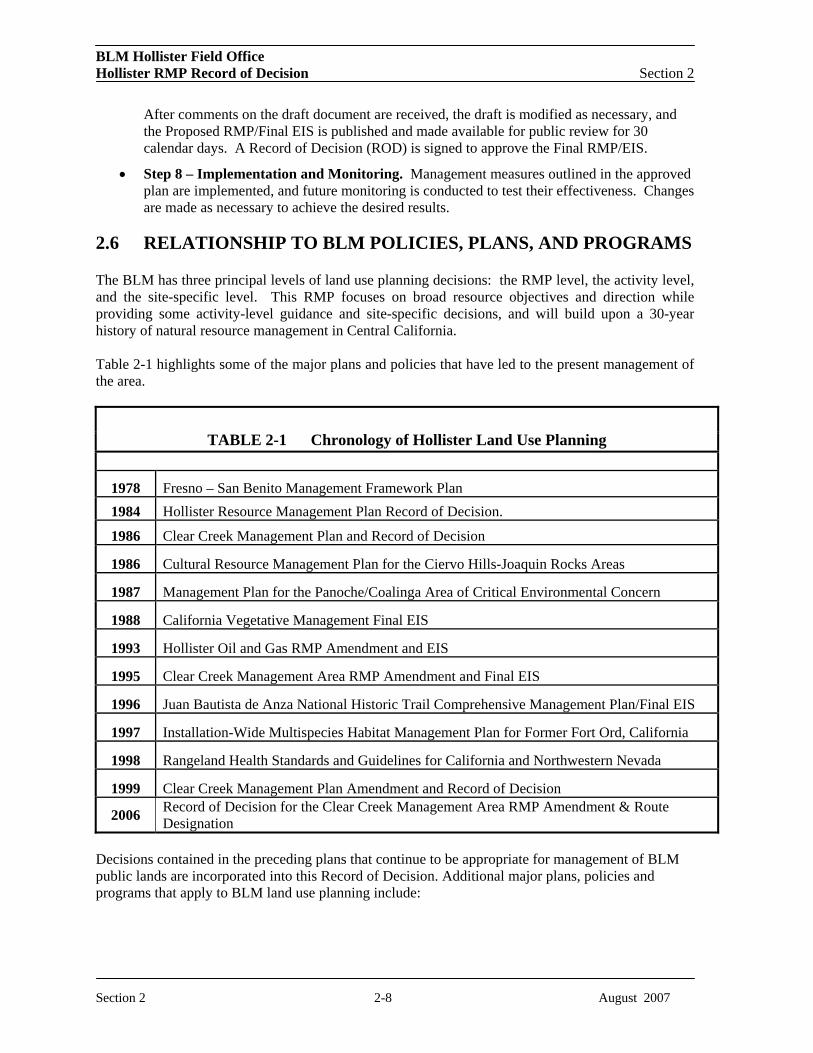
2.6 RELATIONSHIP TO BLM POLICIES, PLANS, AND PROGRAMS
The BLM has three principal levels of land use planning decisions: the RMP level, the activity level, and the site-specific level. This RMP focuses on broad resource objectives and direction while providing some activity-level guidance and site-specific decisions, and will build upon a 30-year history of natural resource management in Central California.
Table 2-1 highlights some of the major plans and policies that have led to the present management of the area.
TABLE 2-1 Chronology of Hollister Land Use Planning
1978 Fresno – San Benito Management Framework Plan 1984 Hollister Resource Management Plan Record of Decision.
1986 Clear Creek Management Plan and Record of Decision
1986 Cultural Resource Management Plan for the Ciervo Hills-Joaquin Rocks Areas
1987 Management Plan for the Panoche/Coalinga Area of Critical Environmental Concern
1988 California Vegetative Management Final EIS
1993 Hollister Oil and Gas RMP Amendment and EIS
1995 Clear Creek Management Area RMP Amendment and Final EIS
1996 Juan Bautista de Anza National Historic Trail Comprehensive Management Plan/Final EIS
1997 Installation-Wide Multispecies Habitat Management Plan for Former Fort Ord, California
1998 Rangeland Health Standards and Guidelines for California and Northwestern Nevada
1999 Clear Creek Management Plan Amendment and Record of Decision
2006 Record of Decision for the Clear Creek Management Area RMP Amendment & Route Designation
Decisions contained in the preceding plans that continue to be appropriate for management of BLM public lands are incorporated into this Record of Decision. Additional major plans, policies and programs that apply to BLM land use planning include:
Section 2 2-8 August 2007

BLM Hollister Field Office Hollister RMP Record of Decision Section 2
Rangeland Health Standards and Guidelines The Central California standards for rangeland health and guidelines for livestock grazing management were adopted in 2000 for managing grazing on BLM public lands in the planning area. BLM is required by policy to use these standards and guidelines for evaluating rangeland health.
California Vegetation Management Environmental Impact Statement This 1988 EIS describes and analyzes the consequences of implementing a program to control vegetation on public lands in California. While this EIS addresses the impacts of different vegetation control techniques, subsequent environmental analyses will be prepared in conformance with the revised Hollister RMP/EIS, which will address site-specific impacts of individual projects.
BLM Wilderness Recommendations Wilderness studies were completed for all BLM lands as a requirement under Section 603 of the FLPMA, and recommendations have been formally submitted to Congress by the President. Therefore, these decisions cannot be changed except by Congressional action. In the Planning Area, approximately 22,287 acres are being managed in four Wilderness Study Areas until Congress makes the final wilderness determination through legislative action.
California Coastal National Monument Resource Management Plan The BLM released the Resource Management Plan for the California Coastal National Monument (CCNM) in September 2005. The document details the management strategy for approximately 20,000 rocks, small islands, exposed reefs, and pinnacles off the 1,100-mile length of the California coast. These features, encompassing about 1,000 acres, are within a 14,600 square nautical mile (NM) area extending from the mean high tide line out to 12 NM, as delineated by the presidential proclamation establishing the California Coastal National Monument on January 11, 2000.
Overall, the RMP for the CCNM focuses on protection of the scenic and geologic formations of the monument and the habitat they provide for seabirds, sea mammals, and unique vegetation. The RMP also discusses provisions for research, education, and additional planning through collaboration, cooperation, and coordination with agencies and organizations that have natural and/or cultural resources management responsibilities along the coast. Five BLM field offices have jurisdiction over portions of the California coast, including the HFO. Each of these field offices has a plan that guides policies and land use. The CCNM RMP amends these other BLM plans where inconsistencies exist between the CCNM RMP and those plans.
National Off-highway Vehicle Strategy The BLM released a National Management Strategy for Motorized Off-highway Vehicle (OHV) Use on Public Lands on January 19, 2001. This strategy is aimed at recognizing the interests of motorized OHV users while protecting environmentally sensitive areas on the public lands. It also seeks to focus the Agency’s scarce funding and staffing resources on motorized OHV management on the ground at the local field office level.
National Mountain Bike Strategy The BLM’s National Mountain Bicycling Strategic Action Plan is a comprehensive approach to addressing issues regarding mountain bicycling and other mechanical transport activities on public lands. This Action Plan focuses on guidance and actions for BLM field office managers and staff, interest groups, and individuals. It provides innovative and proactive approaches to protect soil, water, wildlife habitat, threatened or endangered plant and animal species, native vegetation, heritage
Section 2 2-9 August 2007

BLM Hollister Field Office Hollister RMP Record of Decision Section 2
resources, and other resources while providing for high-quality, environmentally responsible recreational opportunities. Implementation of this Action Plan will be an ongoing, adaptive approach that will require the continued cooperation and participation of the public.
Bird Conservation Plans The Point Reyes Bird Observatory (PRBO) has developed an approach to address bird conservation and habitat issues on a continental scale in cooperation with a voluntary, international coalition known as Partners In Flight (PIF). Formed in 1990, PIF was originally dedicated to reversing the decline of neotropical migratory songbirds but soon expanded its mission to include all land birds.
The California Partners In Flight (CalPIF) program has completed six habitat- and bioregion-based Bird Conservation Plans (BCPs) for riparian, oak woodlands, coastal scrub and chaparral, grasslands, coniferous forests, and the Sierra Nevada bioregion. One of the main goals of the CalPIF BCP is to document the health and status of bird populations across the entire state. To this end, the PRBO has developed a database of CalPIF bird monitoring sites and has served as a repository for species breeding-status information for the entire state. Combined with the associated CalPIF study areas database and focal species breeding-status database, these plans provide the foundation for adaptive conservation management in California’s habitats.
Wind Energy Development Program The BLM is responsible for the development of wind energy resources on BLM-administered lands. Currently, about 500 megawatts (MW) of wind capacity are installed nationwide under right-of-way (ROW) grants administered by the BLM.
The BLM’s Programmatic EIS for Wind Energy Development was released as a final document in June 2005. The Wind Energy EIS establishes policies and best management practices (BMPs) for ensuring that the impacts of wind energy development on BLM-administered lands will be kept to a minimum. The policies and BMPs are applicable to all wind energy development projects. These elements of the program, along with a proposed universal amendment to land use plans, will result in shorter time lines and reduced costs for wind energy projects, thereby facilitating development. In addition, it would ensure consistency in the way ROW applications and grants for wind energy development are managed.
Native American Consultation per Executive Orders 12866, 13084, et seq. Executive Order 12866 is intended to enhance planning and coordination with respect to both new and existing regulations and to make the process more accessible and open to the public. Executive Order 13084 establishes requirements for meaningful consultation and collaboration with Indian tribal governments in the development of regulatory practices on Federal matters that significantly or uniquely affect their communities.
CFR Title 43, Section 1610, and BLM Manual 1601 and Handbook 1601 on Land use Planning 43 CFR 1610 states that guidance for preparation and amendment of resource management plans may be provided by the Director and State Director, as needed, to help the District and Area Manager and staff prepare a specific plan.
Section 2 2-10 August 2007
BLM Hollister Field Office Hollister RMP Record of Decision Section 2
The 1601 Manual and 1601 Handbook provide guidance to the BLM on the requirements of the FLPMA, the BLM’s Planning Regulations (43 CFR 1600), and NEPA. Nothing in the Manual or Handbook supersedes the legal and regulatory mandates in the CFR. The Manual and Handbook provide guidance for preparing new RMPs, plan revisions, plan amendments, other equivalent plans (e.g., plans adopted from other agencies), and subsequent implementation-level plans. Procedures and requirements are set forth to ensure that the BLM’s plans meet regulatory and statutory requirements. To the extent possible, this guidance integrates land use planning requirements with requirements under NEPA.
2.6.1 Consultation and Coordination
Intergovernmental and Interagency
The RMP revision will allow the BLM the opportunity to review existing agreements and consider cooperative agreements with the Federal, State, and local agencies to improve management of public land resources in the Planning Area. These agencies include:
• U.S. Environmental Protection Agency
• U.S. Fish and Wildlife Service
• U.S. Army Corps of Engineers
• California Department of Forestry and Fire Protection
• California State Historic Preservation Office
• California Department of Fish and Game
• California Regional Water Quality Control Board
• Monterey Bay Air Pollution Control Board
Previous formal consultations with the USFWS were conducted for livestock grazing in the San Joaquin Valley with a Biological Opinion (BO) issued in 1993 and for the Hollister Oil and Gas RMP Amendment with a Biological Opinion issued in 1994. Section 7 consultation regarding Fort Ord route management, habitat enhancement, integrated weed management, fuel break construction and maintenance, aquatic monitoring, and educational programs was completed on December 30, 2005, following the issuance of a BO from the USFWS. Subsequent coordination with the USFWS Sacramento Office and Ventura Office has been ongoing throughout the Hollister RMP/EIS planning process, with frequent communications and meetings to discuss the development of the Biological Assessment for the Hollister Proposed RMP and Final EIS and the associated Biological Opinion from the FWS.
Coordination with the EPA by phone, through various meetings, and coordination of studies has also occurred throughout the planning process. Topics discussed include comments on the Draft EIS, air and water quality, and human health risks associated with exposure to naturally occurring asbestos.
Coordination with other agencies and consistency with other agency and local and state government plans were accomplished through frequent communications and cooperative efforts between BLM and involved federal, State, and local agencies. The California Governor’s Clearinghouse received copies of the Draft and Proposed RMP(s) for comment and review to ensure consistency with
Section 2 2-11 August 2007

BLM Hollister Field Office Hollister RMP Record of Decision Section 2
ongoing state plans. The California Office of Historic Preservation also received a copy of the Draft and Proposed RMP(s).
Tribal Relationships
The Tachi Yokut tribe of the Santa Rosa Rancheria is the only federally recognized Native American group in the Planning Area. Personal contacts between BLM officials and tribal representatives are routinely scheduled for other planning activities in the HFO, and the BLM extended the opportunity to provide input for the RMP revision to the Tachi Yokut tribe throughout the planning process.
Other Stakeholder Relationships
The BLM HFO participates in the following regional Coordinated Resource Management Planning (CRMP) groups: • Arroyo Pasajero Watershed CRMP,
• Cantua Creek Watershed CRMP,
• Pajaro Watershed CRMP,
• Panoche-Silver Creek Watershed CRMP, and
• Fort Ord CRMP.
Coordinated resource management is a voluntary planning process that has proven to be successful in the management of natural resources and is rapidly gaining acceptance nationwide as an essential tool in watershed management. The CRMP process allows local people to provide input in making and implementing proactive natural resource management decisions. It involves bringing all affected stakeholder groups together to set common goals and resolve resource issues as a team.
2.7 POLICY
A broad range of Federal laws guide development of the RMP revision. Key laws with bearing on the planning decisions are discussed below.
Federal Land Policy and Management Act The FLPMA establishes the authority and provides guidance for how public lands are to be managed by the BLM. In managing public lands on the basis of multiple use and sustained yield, the FLPMA requires that the quality of scientific, scenic, historical, ecological, environmental, air and atmospheric, water resource, and archaeological values be protected. The revised RMP/EIS will not terminate any valid ROW or customary operation, maintenance, repair, or replacement activities in existing ROWs on BLM lands.
National Environmental Policy Act This legislation established a national policy to maintain conditions under which people and nature can exist in productive harmony and fulfill the social, economic, and other requirements of present and future generations of Americans. NEPA established the CEQ to coordinate environmental matters at the Federal level and advise the President on such matters. The law requires all Federal actions that could result in a significant impact on the environment to be subject to review by Federal, tribal, state, and local environmental authorities, as well as affected parties and interested citizens.
Section 2 2-12 August 2007

BLM Hollister Field Office Hollister RMP Record of Decision Section 2
Endangered Species Act Management activities on private and public lands are subject to the Federal Endangered Species Act of 1973 (ESA), as amended. The ESA directs project proponents or government agencies, as appropriate, to consult with the U.S. Fish and Wildlife Service (USFWS) and/or National Oceanic and Atmospheric Administration Fisheries Service (NOAA Fisheries) to address the effects of management activities on threatened and endangered species and designated critical habitats. Consultation leads to the issuance of a Biological Opinion and may result in issuance of a Section 10(a) permit (for non-Federal actions) or a Section 7 permit (for Federal actions) by the USFWS and/or NOAA Fisheries.
National Historic Preservation Act The National Historic Preservation Act (NHPA) is the primary Federal law providing for the protection and preservation of cultural resources. The NHPA established the National Register of Historic Places, the Advisory Council on Historic Preservation, and the State Office of Historic Preservation.
Migratory Bird Treaty Act The Migratory Bird Treaty Act (MBTA) is the domestic law that implements the United States’ commitment to four international conventions (with Canada, Japan, Mexico, and Russia) for the protection of a shared migratory bird resource. The MBTA decrees that all migratory birds and their parts (including eggs, nests, and feathers) be fully protected. Each of the conventions protects selected species of birds that are common to multiple countries (i.e., they occur in both countries at some point during their annual life cycle). The MBTA is implemented by the USFWS. BLM will be required to manage the bird populations on BLM-administered public lands consistent with the requirements of the MTBA.
Anadromous Fish Management The Interim Management Strategies for Managing Anadromous Fish-Producing Watersheds on Federal Lands in Eastern Oregon and Washington, Idaho, and portions of California (PACFISH 1995) amended land use plans to include these standards and guidelines for all management activities. The decisions in the revised Hollister RMP incorporate the PACFISH standards and guidelines and will be consistent with and/or complementary to these strategies. Activity plans and implementation of projects pursuant to a revised Hollister RMP may further refine PACFISH implementation.
2.8 OVERALL VISION
The overall vision of BLM public lands management, derived from public scoping, inter-agency dialogue, and the BLM’s interdisciplinary team, is to “maintain and improve natural, cultural, and open space values across a variety of central California landscapes through partnerships and collaboration, for the enjoyment and use of a growing and diverse population of current and future generations.”
Section 2 2-13 August 2007

BLM Hollister Field Office Section 3 Hollister RMP Record of Decision
3.0 HOLLISTER RESOURCE MANAGEMENT PLAN
This chapter details the approved management actions for this Bureau of Land Management (BLM) Hollister Field Office (HFO) Resource Management Plan (RMP). Eighteen program areas and the approved management actions for each program are described in this chapter. The land use management actions described in this chapter address identified issues, management concerns, and current and projected future uses of the lands administered by the HFO in the Planning Area.
3.1 Air Quality
3.1.1 Goals and Objectives
The goal for air quality management is to ensure that BLM authorizations and management activities comply with local, State, and Federal air quality regulations, requirements, State Implementation Plans (SIPs), and Regional Air Board standards and goals.
To achieve this goal, the following objectives are established:
• Manage prescribed fires to comply with established air quality standards;
• Manage energy and mineral development to avoid degradation of established air quality standards; and
• Coordinate with Regional Air Quality Control Districts on resource management activities to ensure consistency with State air basin plans.
3.1.2 Area-wide Management Actions
AIR-COM1. Incorporate mitigation for activities and projects on BLM lands in order to comply with applicable Federal, State, and local air quality regulations.
AIR-COM2. Manage motorized vehicle travel on dirt roads to minimize air pollution from dust and exhaust by restricting vehicle types and seasons when vehicles could be used.
AIR-COM3: Manage fires to minimize smoke and coordinate with Federal, State, and local governments in smoke-sensitive areas to comply with local Smoke Management Programs.
3.1.3 Central Coast Management Area Actions
AIR-C1. Coordinate with the Monterey Bay Unified Air Pollution Control District (APCD) to predict impacts on air quality from prescribed burns on Fort Ord Public Lands. Develop criteria for prescribed burns with the Monterey APCD to avoid air quality degradation beyond established air quality standards.
Section 3 3-1 August 2007

BLM Hollister Field Office Section 3 Hollister RMP Record of Decision
3.2 Soil Resources 3.2.1 Goals and Objectives
The goal for soil resources management is to manage soil on BLM lands such that functional biological and physical characteristics that are appropriate to soil type, climate, and land form are exhibited (Rangeland Health Standards and Guidelines 2000).
To achieve this goal the following objectives are established:
• Control erosion and sediment transport;
• Maintain vegetation cover at or above the level necessary to stabilize soils; and
• Protect and restore biological soil crusts on watersheds.
3.2.2 Area-wide Management Actions
SOIL-COM1. Require an approved erosion control strategy and topsoil segregation/restoration plan for proposals involving surface disturbance on slopes of 20 to 40 percent. Such construction must be properly surveyed and designed by a certified engineer and approved by the BLM before construction and maintenance. No surface disturbance on slopes greater than 40 percent would be allowed unless it is determined that it would cause a greater impact to pursue other alternatives.
SOIL-COM2. Require a topsoil segregation/restoration plan be submitted to and approved by the BLM before construction and maintenance actions that would disturb the surface of soils considered to have poor topsoil suitability or restoration potential.
SOIL-COM3. Close roads and trails to public use during periods of extreme wet weather in areas where sustained public use may compromise the integrity of the road or trail surface.
SOIL-COM4. Implement soil loss assessment procedures for road and trail maintenance;
SOIL-COM5. Implement best management practices (BMPs) for non-point source pollution control;
3.3 Water Resources 3.3.1 Goals and Objectives
The goals for water resources management are to (1) maintain, restore, or improve water quality and quantity to sustain the designated beneficial uses on BLM lands and (2) ensure that surface and groundwater quality comply with the Clean Water Act (CWA) and with California State standards.
To achieve this goal the following objectives are established:
• Maintain the existing quality and beneficial uses of water; protect waters where they are threatened; and restore currently degraded waters. This objective is of even higher priority in the following situations:
Section 3 3-2 August 2007

BLM Hollister Field Office Section 3 Hollister RMP Record of Decision
– Where the beneficial uses of water bodies have been listed as threatened or impaired pursuant to Section 303(d) of the CWA; and
– Where aquatic habitat is present or has been present for Federal threatened or endangered species, candidate species, and other special status species (Section 3.6) dependent on water resources.
• Protect all designated beneficial uses by preventing or limiting non-point source pollution.
3.3.2 Area-wide Management Actions
WAT-COM1. Implement BMPs at the activity-plan or project level to prevent degradation of water quality.
WAT-COM2. Maintain existing developed water sources (i.e., spring developments and reservoirs). Develop new sources on a case-by-case basis through project-level planning.
WAT-COM3. Maintain adjudicated water rights; inventory water sources not adjudicated or water rights sought, where applicable.
WAT-COM4. Manage CWA 303(d)-listed impaired water bodies to meet properly functioning condition (PFC) objectives relative to beneficial uses and total maximum daily loads (TMDLs).
WAT-COM5. Maintain stable watershed conditions and implement passive and active restoration projects to protect beneficial uses of water and meet TMDLs.
WAT-COM6. Work with Regional Water Quality Control Boards, Coordinated Resource Management Planning groups, and other private landowners or non-profit organizations to prioritize watershed improvement projects and establish monitoring programs to prevent water bodies from reaching impairment levels that would result in listing under CWA 303(d).
WAT-COM7. Limit authorized uses and management activities to those that do not cause irreversible, irreparable impacts to water quality and watershed function.
WAT-COM8. Periodically monitor water quality in seasonal pools and perennial ponds containing known or suspected threatened and endangered (T & E) species. Identify water quality issues and initiate repairs, within environmental constraints.
WAT-B2. Submit request to the California State Department of Water Resources to establish Federal water reserves on acquired lands to ensure water availability for multiple use management and for functioning, healthy, riparian and upland systems.
WAT-C1. Manage all fluvial systems functioning at risk to meet PFCs.
3.3.3 Central Coast Management Area Actions
WAT-COM9. Upon completion, fulfill aquatic, wetland, and riparian habitat management and restoration requirements outlined in the Fort Ord Habitat Conservation Plan.
Section 3 3-3 August 2007

BLM Hollister Field Office Section 3 Hollister RMP Record of Decision
3.4 Biological Resources – Vegetation Resources 3.4.1 Goals and Objectives
The goals for vegetation resources are to (1) restore, maintain, or improve ecological conditions, natural diversity, and associated watersheds of high value, high-risk native plant communities and unique plant assemblages and (2) to restore degraded landscapes and plant communities.
To achieve this goal the following objectives are established:
• Provide a mosaic of vegetative communities to protect soil, watershed, and wildlife; maintain sustained yield of vegetation for consumptive and non-consumptive uses.
• Rehabilitate disturbed areas to stabilize soils and promote growth of desired plant communities;
• Prevent the introduction and proliferation of noxious and invasive weeds.
3.4.2 Area-wide Management Actions
VEG-COM1. Issue woodcutting permits on a case-by-case basis. Only allow commercial harvesting consistent with resource management goals and objectives to control the spread of disease and invasive and non-native species and to reduce the risk of catastrophic fire.
VEG-COM2. Include mitigation measures to protect or enhance riparian areas in all activity or project plans.
VEG-A2. Manage the native perennial grassland as a sensitive community to maintain or increase populations.
VEG-C1. Rehabilitate vegetative cover following wildland fires and/or other surface-disturbing activities in a timely manner. Allow use of non-persistent (or temporary), non-native, non-invasive species to be used in re-vegetation materials.
VEG-C2. Use livestock grazing to improve ecological conditions and increase forage production (see RANG-C8).
VEG-C3. Mitigate or relocate proposed activities within 250 feet of riparian vegetation if the activities have long-term negative impacts on riparian resources.
VEG-C4. Initiate riparian restoration/improvement projects within systems that have been identified as not functioning or functioning at risk with a downward or static trend.
VEG-C5. Prioritize noxious or invasive weed treatment in accordance with BLM's policy of early detection, rapid response. Priority noxious or invasive weed species identified for treatment will be based on the California Department of Food and Agriculture, Division of Plant Industry, Pest Ratings of Noxious Weed Species, and/or the California Invasive Plant Council Invasive Plant list.
VEG-C6. Expand the use of an Integrated Pest Management program to prevent the introduction and proliferation of noxious and invasive weeds on 10,000 acres within 10 years throughout the resource area.
Section 3 3-4 August 2007

BLM Hollister Field Office Section 3 Hollister RMP Record of Decision
VEG-C7. Issue non-commercial permits for collecting vegetation in response to public demand. Monitor resource conditions to determine if a limit on personal-use permits is necessary. Consider commercial-use permits on a case-by-case basis.
3.4.3 Central Coast Management Area Actions
VEG-C9. Use a mixture of management activities, including prescribed burns and mechanical treatments, to manage and maintain the composition, mixed age classes, and native wildlife habitat of maritime chaparral and Douglas fir/tan oak woodland.
3.4.4 San Joaquin Management Area Actions
VEG-C10. Implement a Russian thistle abatement program for alkali desert scrub, John Tucker-Alvordiana oak woodland, and saltbrush.
3.5 Biological Resources – Wildlife Habitat 3.5.1 Goals and Objectives
The goal for fish and wildlife is to ensure diverse, structured, resilient, and connected habitat on a landscape level to support viable and sustainable populations of wildlife, fish, and other aquatic organisms.
To achieve the goal for fish and wildlife, the following objectives are established:
• Maintain or enhance viable, healthy, and diverse populations of native and desired species, including special status species, where appropriate.
• Conserve habitat consistent with the Installation-Wide Multi-species Habitat Management Plan for Former Fort Ord, California.
• Conserve habitat for migratory birds and species listed on the U.S. Fish and Wildlife Service (USFWS) list of Birds of Conservation Concern.
3.5.2 Area-wide Management Actions
HAB-COM1. Coordinate with the Animal and Plant Health Inspection Service (APHIS), the California Department of Fish and Game (CDFG), and the USFWS to control non-native wildlife species. Conduct monitoring and facilitate research to increase the public’s awareness and scientific knowledge regarding these resources.
HAB-C1. Evaluate functioning guzzlers and spring developments for benefits to wildlife habitat and recreation to determine the need to increase or decrease water improvements in arid regions.
HAB-C2. Limit disturbance, within a distance of up to 0.5 miles of nesting special status raptors (e.g., California condor, bald eagle, golden eagle, Swainson's hawk, sharp-shinned hawk, northern harrier, peregrine falcon, and burrowing owl) during courtship, nest building, incubation, and fledging periods. Limit disturbance to other raptor species, including State species of concern (e.g., osprey, sharp-shinned hawk, northern harrier, ferruginous hawk, prairie falcon, short-eared owl, long-eared
Section 3 3-5 August 2007

BLM Hollister Field Office Section 3 Hollister RMP Record of Decision
owl) and common species (e.g., red-tailed hawk and American kestrel) during critical periods of their reproductive cycle on a case-by-case basis.
HAB-C3. Cooperate with the CDFG to reintroduce, release, and/or restore populations of native fish and wildlife species into historic and occupied ranges with suitable habitat. Consider supplemental releases of game on a case-by-case basis, except for feral pigs.
3.5.3 Central Coast Management Area Actions
HAB-COM2. Preserve fallen trees, snags, and duff in occupied and potential habitat for the Monterey ornate shrew. Prohibit collecting wood in areas known to provide habitat.
HAB-COM3. Mitigate or relocate man-made barriers that substantially impede migration outside of wildlife travel corridors, as appropriate.
HAB-B6. Coordinate with local animal control agencies to remove feral animals from BLM public lands.
HAB-C5. Establish an education program addressing the effects of dogs and cats on wildlife and wildlife habitat.
3.6 Biological Resources – Special Status Species 3.6.1 Goals and Objectives
The goal for management of special status species is to (1) protect and/or improve habitat necessary to recover populations of special status species and (2) manage BLM land to maintain, restore, or enhance populations and habitat of special status fish, wildlife, and plant species.
To achieve the goal for management of special status species, the following objectives are established:
• Manage listed, proposed, or candidate threatened or endangered species to comply with the provisions of the Endangered Species Act (ESA).
• Manage special status plants consistent with BLM policy on Special Status Species Management (BLM Manual 6840).
• Prevent the need for listing proposed, candidate, and sensitive species under the ESA
• Improve the condition of special status species and their habitats to a point where their special status recognition is no longer warranted.
3.6.2 Area-wide Management Actions
SSS-COM1. Prohibit the collection of species status species, except for authorized restoration projects, BLM-permitted scientific research, or for Native American traditional practices.
SSS-COM2. Monitor and maintain upland habitat for the California tiger salamander.
Section 3 3-6 August 2007

BLM Hollister Field Office Section 3 Hollister RMP Record of Decision
SSS-C1. Maintain, restore, or enhance special status species habitat.
SSS-C2. Limit proposed new surface-disturbing activities within occupied or potential habitat for special status species and significant plant communities. Limit long-term disturbances in potential habitat.
SSS-C3. Mitigate or relocate activities that disturb, alter, or interrupt hydrologic or ecological processes that support special status species.
3.6.3 Central Coast Management Area Actions
SSS-COM3. Protect ponds, wetlands, or riparian areas known to support or that could potentially support California tiger salamander, red-legged frog, or California linderiella to maintain natural corridors between pools/wetlands and upland habitat so that continuous native plant coverage allows adequate movement of these species.
SSS-C4. Restrict public and pet access to all ponds at Fort Ord Public Lands known or suspected to support special status aquatic species during important breeding and gestation periods.
3.7 Fire Management 3.7.1 Goals and Objectives
The goals for fire management are to (1) establish a fire management program that is cost-efficient and commensurate with threats to life, property, public safety, and resources, (2) use fire to restore and/or sustain ecosystem health, (3) cooperate with communities at risk within the wildland-urban interface to develop plans for risk reduction, (4) cooperate with regional partners in fire and resource management across agency boundaries, and (5) reduce man-made fires, with a special emphasis on reductions in developed areas such as communities, campgrounds, and transportation corridors.
To achieve the goals for fire management, the following objectives are established:
• Wildfire Suppression
– Provide for firefighter and public safety in all fire-management activities.
– Provide an appropriate management response for all wildland fires, emphasizing firefighter and public safety. Areas of Critical Environmental Concern (ACECs), Special Recreation Management Areas (SRMAs), Wilderness Areas (WAs), Wilderness Study Areas (WSAs), and certain other public lands will require modified suppression techniques to protect the known values. Modified suppression techniques are identified in the Hollister Fire Management Plan (FMP).
– Limit the intensity of fire suppression efforts to the most economical response consistent with the human and resource values that are at risk.
– Protect sensitive cultural and paleontological resource sites from damage by fire and/or fire suppression actions.
• Fuels Management
– Reduce the risk of fire in wildland-urban interface communities.
Section 3 3-7 August 2007

BLM Hollister Field Office Section 3 Hollister RMP Record of Decision
– Reduce the risk of catastrophic wildfire through fuels management.
– Promote greater diversity within plant communities of the HFO with the use of fire.
– Use fire as natural land management tool for the control and eradication of noxious and invasive weeds.
– Use fire as a management tool to improve the ecological condition of the area within HFO jurisdiction.
– Use prescribed burning to reduce the fuel hazard in the chaparral community and for wildlife habitat improvement and increased local water yield and watershed enhancement.
• Fire Rehabilitation, Stabilization, and Restoration
– Rehabilitate burned areas to mitigate adverse effects of fire on soils, water, and cultural resources and vegetation.
• Prevention, Risk Mitigation, and Education
– Increase the public’s knowledge of fire’s natural role in the ecosystem and the hazards and risks associated with living in the wildland-urban interface.
– Educate the public on fire safety and prevention measures.
• Work with the California Department of Forestry and Fire Protection (CDF) to suppress all wildfires involving less than 10 acres 90 percent of the time.
3.7.2 Area-wide Management Actions
FIRE-COM1. Develop and maintain the Hollister Fire Management Plan.
FIRE-COM2. Identify appropriate management response goals, objectives, and constraints by specific Fire Management Units (FMUs) in the Hollister Fire Management Plan (see Figure 7).
FIRE-COM3. Employ fire prevention strategies that reduce man-made fires, with special emphasis on developed areas such as communities, campgrounds, and transportation corridors.
FIRE-COM4. Develop fuels projects to mimic fire’s natural role in enhancing resource values.
FIRE-COM5. Coordinate with the CDF or cooperating fire protection entities to develop appropriate management response actions, as documented in the annual operating plan, for wildland fires on or threatening BLM lands. Primary consideration and operational emphasis are placed on firefighter and public safety, minimizing the loss of life and damage to private property, minimizing environmental damage due to suppression efforts, and considering resource values and high value habitat at risk from unwanted wildfire.
FIRE-COM6. Identify high priority wildfire risk areas (e.g., wildland-urban interface, critical habitats and cultural areas).
• See the Hollister Fire Management Plan.
• The FMP displays the list of values at risk and the communities at risk within each FMU.
• These lists may change as communities are removed or added each year.
Section 3 3-8 August 2007

BLM Hollister Field Office Section 3 Hollister RMP Record of Decision
FIRE-COM7. Work collaboratively with Federal, State, Fire Safe Councils, and local partners to develop cross boundary fire management strategies and prioritize cross agency fire management actions.
FIRE-COM8. Work collaboratively with communities at risk within the wildland-urban interface to develop plans for risk reduction.
FIRE-COM9. Work collaboratively with managing partners to design and implement prescribed fire and fuels management projects across agency boundaries where this interaction would improve the overall success of the project.
FIRE-COM10. Restrict the application of fire retardants 200 to 300 feet from rock outcroppings, waterways, vernal pools, and wetlands to minimize adverse effects on listed species and prevent damage to rock art sites.
FIRE-COM11. Establish a fire-effects monitoring system that inventories pre-burn species composition and resulting post-fire response, over time.
FIRE-COM12. Monitor fire/fuels treatment effects and adjust the Hollister FMP as needed.
FIRE-COM13. Implement a chaparral management program within the HFO area to use fire to improve wildlife habitat.
FIRE-COM14. Protect the primitive nature of public lands within the Panoche Hills WSAs from any action affecting the overall “naturalness” of the area.
FIRE-COM15. Prohibit the use of heavy mechanical equipment within the Panoche Hills WSAs. This restriction may be lifted by the Field Manager to protect human life, private property, structures, visitor safety, or sensitive or valuable resources.
FIRE-COM16. Develop local or regional “Normal Fire Year Rehabilitation Plans.”
FIRE-COM17. Promote the use of native species in reseedings.
FIRE-COM18. Monitor rehabilitation efforts to facilitate future planning and implementation.
FIRE-COM19. Allow commercial biomass harvesting within the Fort Ord FMU as appropriate to help accomplish fuels-reduction goals.
Table 3.7-1 Prescribed Fire Target Acres
Geographic Area/Management Area Average Annual Acres
Proposed Plan Salinas Management Area Sierra de Salinas FMU – 8,500 acres 425 Williams Hill FMU – 7,000 acres 350 Parkfield FMU (Stockdale Mountain – 2,000 acres) 100 San Joaquin Management Area San Joaquin Valley South Continued FMU (Coalinga Mineral Springs – 6,500 acres) 725
Section 3 3-9 August 2007
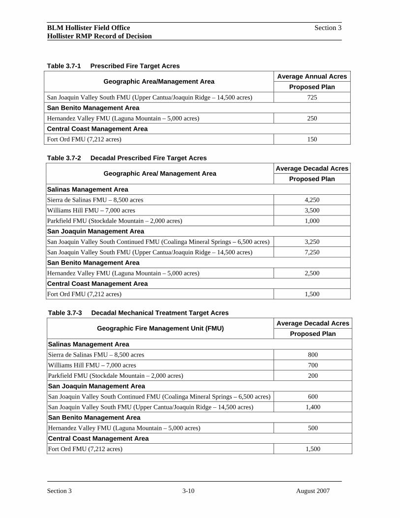
BLM Hollister Field Office Section 3 Hollister RMP Record of Decision
Table 3.7-1 Prescribed Fire Target Acres
Geographic Area/Management Area Average Annual Acres
Proposed Plan San Joaquin Valley South FMU (Upper Cantua/Joaquin Ridge – 14,500 acres) 725 San Benito Management Area Hernandez Valley FMU (Laguna Mountain – 5,000 acres) 250 Central Coast Management Area Fort Ord FMU (7,212 acres) 150
Table 3.7-2 Decadal Prescribed Fire Target Acres
Geographic Area/ Management Area Average Decadal Acres
Proposed Plan Salinas Management Area Sierra de Salinas FMU – 8,500 acres 4,250 Williams Hill FMU – 7,000 acres 3,500 Parkfield FMU (Stockdale Mountain – 2,000 acres) 1,000 San Joaquin Management Area San Joaquin Valley South Continued FMU (Coalinga Mineral Springs – 6,500 acres) 3,250 San Joaquin Valley South FMU (Upper Cantua/Joaquin Ridge – 14,500 acres) 7,250 San Benito Management Area Hernandez Valley FMU (Laguna Mountain – 5,000 acres) 2,500 Central Coast Management Area Fort Ord FMU (7,212 acres) 1,500
Table 3.7-3 Decadal Mechanical Treatment Target Acres
Geographic Fire Management Unit (FMU) Average Decadal Acres
Proposed Plan Salinas Management Area Sierra de Salinas FMU – 8,500 acres 800 Williams Hill FMU – 7,000 acres 700 Parkfield FMU (Stockdale Mountain – 2,000 acres) 200 San Joaquin Management Area San Joaquin Valley South Continued FMU (Coalinga Mineral Springs – 6,500 acres) 600 San Joaquin Valley South FMU (Upper Cantua/Joaquin Ridge – 14,500 acres) 1,400 San Benito Management Area Hernandez Valley FMU (Laguna Mountain – 5,000 acres) 500 Central Coast Management Area Fort Ord FMU (7,212 acres) 1,500
Section 3 3-10 August 2007

BLM Hollister Field Office Section 3 Hollister RMP Record of Decision
3.8 Recreation
3.8.1 Goals and Objectives
The goals for recreation management are to (1) provide a variety of experiences and settings for a diversity of users and to meet potential changes in demand while minimizing conflicts with adjacent property owners and among user groups; (2) provide a range of recreational use opportunities while protecting sensitive natural and cultural resources from human intrusion; (3) promote sharing of ideas, resources, and expertise to increase the public’s appreciation and understanding of natural and cultural resources on BLM public lands; and (4) disseminate information that will foster responsible behavior in order to achieve the highest possible environmental quality on BLM public lands.
To achieve the goals for recreation management, the following objectives are established:
• Maintain a range of facilities to support recreational uses.
• Design maps and brochures and educational opportunities to improve visitors’ appreciation and understanding of natural and cultural resources on BLM public lands.
• Create experiences and settings appropriate for the desired outcome within developed and undeveloped recreation areas.
• Establish and manage intensive-use areas, where the presence of high quality natural resources and the current or potential demand warrants intensive management practices to protect areas for their scientific, educational, and/or recreational values while accommodating anticipated increases in recreational activities in specific areas.
• Manage recreational facilities to protect natural resources and to meet user needs.
3.8.2 Allowable Uses
3.8.2.1 Area-wide Management Actions
Allowable uses for areas in the Proposed RMP are noted in Table 3.8-1. Uses are defined as follows:
• Non-motorized – Non-motorized recreation includes hiking, backpacking, bird and wildlife viewing, equestrian use, environmental education, sightseeing, picnicking and photography. Non-motorized recreation does not include activities listed as motorized or mechanized recreation.
• Mechanized – Mechanized recreation includes cycling, mountain biking, hang-gliding, and rock-climbing using assistive devices.
• Motorized – Motorized recreation includes the use of off-highway vehicles (OHVs) (as described in the Travel Management and Route Designation section) and car touring.
Table 3.8-1 Recreation Allowable Uses for the Hollister RMP Area Allowable Use
Fort Ord Public Lands Non-motorized; Mechanized; Motorized limited Joaquin Rocks Non-motorized; Mechanized; Motorized limited to special permit.
Section 3 3-11 August 2007

BLM Hollister Field Office Section 3 Hollister RMP Record of Decision
Table 3.8-1 Recreation Allowable Uses for the Hollister RMP Area Allowable Use
Coalinga Mineral Springs Non-motorized; Mechanized Sierra de Salinas Non-motorized; Mechanized Stockdale Mountain Non-motorized; Mechanized Williams Hill Non-motorized; Mechanized; Motorized Laguna Mountain Non-motorized; Mechanized Panoche Non-motorized; Mechanized (except in WSAs) Tumey Non-motorized; Mechanized Griswold Hills Non-motorized; Mechanized
REC-USE-COM1. Establish Special Recreation Management Areas (SRMAs) (see Figure 9) and Extensive Recreation Management Areas (ERMAs) within the planning area.
• SRMAs – Public lands identified to direct recreation funding and personnel to fulfill commitments made to provide specific, structured recreation opportunities (i.e., activity, experience, and benefit opportunities).
• ERMAs – Recreation management actions are limited to those of a custodial nature. Therefore, actions within ERMAs are generally implemented directly from land use plan decisions and do not require activity-level planning.
Prepare SRMA Plans that detail travel management strategies, limitations on public use, recreation management zone boundaries, special recreational use permit requirements, environmental education strategies, needed infrastructure development, and specific visual resource management objectives. Focus ERMA management actions on facilitating recreational opportunities that provide basic information and access, primarily for activities where visitors are expected to rely on their own equipment, knowledge, and skills.
REC-USE-COM2. Limit occupancy and use for recreational camping to 14 consecutive days per management area.
REC-USE-COM3. Provide hunting and hiking opportunities in conjunction with Henry Coe State Park. Develop a Cooperative Agreement with the park.
REC-USE-COM4. Issue permits for commercial, competitive, educational, and organized group recreational activities.
REC-USE-C1. Establish group size limits for WSAs and ACECs (see subsection 2.2.10, “Special Management Areas”).
3.8.2.2 Central Coast Management Area Actions
REC-USE-COM5. Designate Fort Ord Public Lands as a SRMA.
REC-USE-C2. Allow opportunities for public use after daylight hours under a special recreation use permit system for Fort Ord Public Lands.
Section 3 3-12 August 2007

BLM Hollister Field Office Section 3 Hollister RMP Record of Decision
REC-USE-C3. Establish pet restrictions (e.g., leash policy, exclusion areas) to reduce user conflicts and protect wildlife and livestock on Fort Ord Public Lands.
REC-USE-C4. Authorize motorized public access on a case-by-case basis in remote areas of Fort Ord Public Lands.
REC-USE-C5. Establish initial carrying capacities at current visitor-use levels for Fort Ord Public Lands (see Table 3.8-2) until an activity-level plan is prepared that details visitor management strategies.
REC-USE-C6. Establish the initial maximum duration of permitted events that involve exclusive trail use (commercial and competitive events) at a combined total of 15 days per year for all events for Fort Ord Public Lands.
REC-USE-C7. Evaluate appropriate recreational fishing areas on Fort Ord Public Lands in consultation with the CDFG and USFWS through activity-level SRMA and ACEC planning. In the interim, access to potential fishing areas would be restricted to prevent adverse impacts on special status species.
REC-USE-C8. Prohibit firearms use on Fort Ord Public Lands.
3.8.2.3 San Joaquin Management Area Actions
REC-USE-C10. Designate Joaquin Ridge as a SRMA.
REC-USE-C11. Limit the issuance of special recreation permits in the Joaquin Ridge area to emphasize and promote protection of cultural, biological, and natural resources.
REC-USE-C12. Establish criteria for Special Recreation Permits for organized groups for the Joaquin Ridge area, including the nature of activities, number of vehicles, mode of transportation, number of people, and seasonal restrictions.
REC-USE-C13. Maintain the existing Panoche, Tumey, Griswold Hills SRMAs with an emphasis on providing non-motorized and mechanized recreation opportunities while protecting resources.
REC-USE-C15. Provide a limited number of access permits into the Panoche Hills during the fire season (April 15 through September).
REC-USE-C16. Maintain the existing Coalinga Mineral Springs SRMA for non-motorized, dispersed recreational opportunities while protecting resources.
REC-USE-C17. Establish target shooting areas at Coalinga Mineral Springs.
REC-USE-C19. Maintain the existing Ciervo Hills SRMA.
3.8.2.4 Salinas Management Area Actions
REC-USE-COM6. Designate the Sierra de Salinas and Stockdale Mountain as ERMAs.
Section 3 3-13 August 2007

BLM Hollister Field Office Section 3 Hollister RMP Record of Decision
REC-USE-C20. Designate Williams Hill as a SRMA.
REC-USE-C21. Manage the Stockdale Mountain ERMA primarily for hunting opportunities (foot access).
REC-USE-C22. Provide motorized recreational opportunities in the Williams Hill SRMA.
3.8.2.5 San Benito Management Area Actions
REC-USE-C23. Designate Laguna Mountain as a SRMA with an emphasis on hunting.
3.8.3 Visitor Services
3.8.3.1 Area-wide Management Actions
REC-VIS-COM1. Establish boundary posting and visitor use patrols in recreation areas concurrent with access development or enhancement.
REC-VIS-COM2. Install and maintain informational and directional signs to orient visitors to the rules and regulations on BLM public lands.
REC-VIS-COM3. Establish visitor-use fees on BLM public lands consistent with the Federal Lands Recreation Enhancement Act (2005).
REC-VIS-COM5. Allow development of facilities to protect public safety and allow for interpretation of natural and cultural values.
REC-VIS-COM6. Rehabilitate or temporarily close recreation sites where resources are being degraded.
REC-VIS-C1. Manage existing recreation sites and allow expansion of existing facilities. Establish new recreation sites to meet increased recreation demand while protecting natural and cultural values and providing for public safety.
REC-VIS-C2. Place new signs as appropriate for the desired setting in SRMAs and ERMAs.
3.8.3.2 Central Coast Management Area Actions
REC-VIS-C4. Design and manage trails on Fort Ord Public Lands to emphasize hiking, equestrian, and mountain biking opportunities.
REC-VIS-C5. Provide recreational facilities along the margins and within the interior of Fort Ord Public Lands.
REC-VIS-C6. Design and implement a comprehensive visitor-use allocation system within seven years to allow a moderate increase in visitor use numbers and provide moderate opportunities for solitude. This would be an adaptive allocation system, progressing from limits on commercial groups during popular holiday weekends to requiring permits for all users within established limits on
Section 3 3-14 August 2007

BLM Hollister Field Office Section 3 Hollister RMP Record of Decision
popular holiday weekends to high-use season permits to year-round permits, as needed. In the interim, implement a self-registration permit system to collect visitor data and aid in disseminating information to the public.
3.8.3.3 San Joaquin Management Area Actions
REC-VIS-C7. Acquire additional public access to Joaquin Rocks.
REC-VIS-C8. Maintain the current public access to Joaquin Rocks at Wright Mountain.
REC-VIS-C9. Provide a limited number of facilities adjacent to county-maintained lands and private property in the Coalinga Mineral Springs area.
REC-VIS-COM7. Improve public access to Tumey Hills (primarily for upland game hunting).
REC-VIS-COM8. Provide a limited number of facilities at the Panoche, Tumey, and Griswold Hills.
REC-VIS-COM9. Improve access to BLM lands adjacent to Clear Creek (primarily for hunting).
3.8.3.4 Salinas Management Area Actions
REC-VIS-C10. Acquire public access to the Sierra de Salinas; limit use to low-impact recreational activities.
3.8.4 Interpretation and Education
3.8.4.1 Area-wide Management
REC-INT-COM1. Provide recreation information such as maps, brochures, and educational opportunities to enhance visitors’ experience on BLM public lands.
REC-INT-COM2. To ensure public safety, increase the number of boundary signs at all sites that offer hunting and target shooting opportunities.
REC-INT-COM3. Cooperate with adjacent landowners on land management activities to the extent possible.
REC-INT-COM4. Design and construct outdoor kiosks and displays to provide current, accurate, and descriptive information to facilitate a safe and enjoyable experience on BLM public lands while minimizing negative impacts on resources and surrounding communities.
3.8.4.2 Central Coast Management Area Actions
REC-INT-COM5. Establish an education program addressing impacts and the minimization of impacts of dogs and cats on BLM lands.
Section 3 3-15 August 2007

BLM Hollister Field Office Section 3 Hollister RMP Record of Decision
REC-INT-COM6. Coordinate with California State Parks, the Department of Fish and Game, and gateway communities to develop educational and interpretive programs and materials consistent with the California Coastal National Monument Resource Management Plan.
REC-INT-COM7. Collaborate with various entities to provide interpretive opportunities, such as museums, which offer the best opportunities for developing cooperative cultural resources educational and interpretive programs.
3.9 Visual Resources Management
3.9.1 Goals and Objectives
The goal for visual resource management is to manage public land actions and activities in a manner consistent with visual resource management (VRM) class objectives.
To achieve the goal for visual resource management the following objective is established:
• Protect, maintain, improve, or restore visual resource values by managing all public lands in accordance with the VRM system.
3.9.2 Area-wide Management Actions
VIS-COM1. Manage all acquired lands consistent with the VRM classifications on adjacent public lands.
VIS-COM2. Manage all designated wilderness as VRM Class I.
VIS-COM3. Manage all WSAs as VRM Class I until Congress acts to either designate wilderness or release the WSA from wilderness suitability, at which point evaluate the area to determine the appropriate VRM designation, based on laws, regulations, and policies in place at that time.
VIS-COM4. In the event that a river or stream is designated a Wild and Scenic River (WSR) by Congress, the WSR would be managed as VRM Class I.
VIS-COM5. Apply VRM Class IV standards to all Management Areas unless otherwise stated.
3.9.3 Central Coast Management Area Actions
VIS-COM6. Manage the coastal resources, in cooperation with appropriate agencies and non-profit organizations, to be consistent with the VRM class objectives identified in the California Coastal National Monument RMP.
VIS-C1. Manage Fort Ord Public Lands as VRM Class II.
3.9.4 San Joaquin Management Area Actions
Section 3 3-16 August 2007
BLM Hollister Field Office Section 3 Hollister RMP Record of Decision
VIS-COM7. Manage the Ciervo Hills as VRM Class III.
VIS-COM8. Manage the Griswold/Tumey Hills as VRM Class III.
VIS-COM9. Manage Coalinga Mineral Springs as VRM Class III.
VIS-C2. Manage Joaquin Rocks as VRM Class II.
3.9.5 Salinas Management Area Actions
VIS-COM10. Manage the Sierra de Salinas as VRM Class III.
3.9.6 San Benito Management Area
VIS-COM11. Manage Hernandez Valley, Call Mountain, and Laguna Mountain as VRM Class III.
3.10 Special Management Areas
3.10.1 Areas of Critical Environmental Concern (ACECs) & Research Natural Areas (RNAs)
3.10.1.1 Goals and Objectives
The goals for ACECs and RNAs are to identify and manage ACECs and RNAs to protect and prevent irreparable damage to important historic, cultural, or scenic values, fish and wildlife resources or other natural systems or processes, or to protect life and safety from natural hazards.
3.10.1.2 Area-wide Management Actions
ACEC-COM1. Establishment of an ACEC would not preclude other land uses.
ACEC-COM2. Develop stipulations for scientific research and collection in concert with individuals and institutions involved.
ACEC-COM3. Establish appropriate guidelines that protect special status species habitat from surface-disturbing activities.
ACEC-COM4. Monitor the effects of management activities and uses (predominantly energy and mineral development, recreation, and grazing) on relevant and important values.
ACEC-COM5. Evaluate surface-disturbing activities such as road construction, ground leveling, mining or oil and gas development for potential adverse impacts on fossil resources, cultural resources, and special status species. Do an on-site field exam for all applications within the ACEC. Consult with the USFWS, in accordance with Section 7 of the ESA, if appropriate. If necessary, take protective measures. These measures can be categorized as pre-development, development, and post-
Section 3 3-17 August 2007

BLM Hollister Field Office Section 3 Hollister RMP Record of Decision
development. Such measures are useful not only in evaluating oil and gas applications but all surface-disturbing activities. Not all measures apply in every situation. Evaluate each surface-disturbing action on a case-by-case basis for applicability of the following measures:
Pre-development Protective Measures
ACEC-COM6. Mitigation for vegetation and cultural resources impacts would include the following:
• Avoiding the impact altogether by not taking a certain action or part of an action;
• Minimizing impacts by limiting the degree or magnitude of the action and its implementation;
• Rectifying the impact by repairing, rehabilitating, or restoring the affected environment;
• Reducing or eliminating the impact over time by preservation and maintenance operations during the life of the action;
• Compensating for the impact by replacing or providing substitute resources or environments.
ACEC-C5. Install temporary fencing on a case-by-case basis.
ACEC-C6. Plan access roads and pipelines to use existing roads and trails. New roads should avoid, where possible, cultural resources and populations of special status species and their potential habitat and critical habitat.
ACEC-C7. Consider seasonal limitations for operational activities on a case-by-case basis.
ACEC-C8. Conduct employee awareness of conservation measures to protect the values for which an ACEC is established on an informal basis.
ACEC-C9. Consider surface occupancy in critical or sensitive habitat areas on a case-by-case basis.
Development Protective Measures
ACEC-COM7. Install pipelines/steam lines aboveground and align with roads, where possible.
ACEC-COM8. Determine size and alignment (or orientation) of pads to minimize surface disturbance and habitat loss while at the same time accommodating construction activities (i.e., lengthwise or parallel to existing roads, short side toward sensitive features). Revegetate portions of pads not needed for production purposes as soon as possible.
ACEC-COM9. Contain and/or remove wastewater to a designated disposal site.
ACEC-COM10. Stockpile topsoil from surface-disturbing activities to be used in conjunction with revegetation efforts.
ACEC-COM11. Maintain buffer zones around cultural resources (100 feet) and sensitive habitat features (minimum of 200 feet from active or inactive kit fox dens; minimum of 100 feet from all intermittent streams; 100 feet from dry washes in blunt-nosed leopard lizard habitat; and minimum of 200 feet from giant kangaroo rat colonies). Use fencing if necessary.
Section 3 3-18 August 2007

BLM Hollister Field Office Section 3 Hollister RMP Record of Decision
ACEC-COM12. Fence or cover all existing and active sumps with fine wire mesh to prevent entrapment of animals.
ACEC-C11. Consolidate locations for maintenance activities where feasible or identify alternative locations. Implement appropriate mitigation measures to minimize impacts.
ACEC-C12. Stipulate in leases for all energy developments that access is limited to two roads.
Post-development Protective Measures
ACEC-COM13. Delineate areas to be rehabilitated in writing, by map, and by staking/flagging on-site.
ACEC-COM14. If in an active field, conduct rehabilitation efforts before the first rainy season after project completion.
ACEC-COM15. If necessary, fence-in revegetated sites (or block with physical barriers) from vehicular or livestock access.
ACEC-COM16. Dispose of all well site debris, including equipment, pipelines, and garbage in an acceptable manner (i.e., remove to a designated disposal site for contaminated soil and/or other debris).
ACEC-COM17. In addition to the protective measures listed above, require compensation in the form of on-site or off-site habitat enhancement (installation of guzzlers, conversion of oil and gas wells to water wells, seeding of native shrub species, etc.). Project applicants may also be required to provide funds for purchase of off-site lands.
ACEC-COM18. Require sheep grazing lessees within ACECs to eliminate sheep trailing and bedding activities from within 200 feet of sensitive habitat areas (giant kangaroo rat colonies and kit fox dens). Also, locate sheep camps at least 200 feet from these areas.
ACEC-COM19. Require cattle grazing lessees within ACECs to eliminate salting or supplemental feed or watering facilities within 200 feet of sensitive habitat areas.
ACEC-COM20. Work with cattle and sheep grazing lessees in on-the-ground meetings at least annually at the beginning of each grazing season.
ACEC-COM21. Preclude predator trapping and rodent poisoning on all BLM surface lands in the subject area. Work with adjacent landowners and counties to the extent possible to avoid placing poison on public land. Monitoring for placement of poison on public land would be a high priority.
ACEC-COM22. Work with cattle and sheep grazing lessees to prevent overgrazing by establishing seasons of use, fencing, control of water, and placement of supplemental feed and salt. Provide fence materials if funds are available.
ACEC-C13. Determine reclamation by the degree of impacts.
Section 3 3-19 August 2007

BLM Hollister Field Office Section 3 Hollister RMP Record of Decision
ACEC-C14. The lessee does all ripping, reseeding, and recontouring of all roads, pads, sumps, and all other past surface disturbances (including oil spills from operations) not of value to the leasehold operation, as approved by the BLM.
ACEC-C15. Reseed with environmentally compatible species, including non-native, non-invasive, non-persistent species, in all disturbed areas within construction zones, as well as any additional locations agreed to for the benefit of special status species and surface protection from erosion.
ACEC-C16. Specify timeframes, rates of seed applications and type of seed for reseeding.
3.10.1.3 Central Coast Management Area Actions
ACEC-C1. Designate all Fort Ord Public Lands managed by BLM as an ACEC to protect unique biological resources, including maritime chaparral habitat and special status species; to promote scientific research and educational opportunities; and in consideration of public safety hazards from previous military operations, including the presence of munitions and explosives of concern (MEC)
Rationale
The proposed designation of the Fort Ord Public Lands ACEC is based on the risk to public safety from the potential presence of MEC on former military lands and special status species associated with the maritime chaparral, grassland and vernal pool habitats. These include the sand gilia, Contra Costa goldfields, Monterey spineflower, Seaside’s bird’s-beak, toro manzanita, sandmat manzanita, Monterey ceanothus, Eastwood’s ericameria, coast wallflower, Hooker’s Manzanita, Congdon’s tarplant, California tiger salamander, and California linderiella, which are known to occur on the Fort Ord Public Lands. The California red-legged frog, black legless lizard, and Monterey ornate shrew are suspected to occur on the Fort Ord Public Lands.
3.10.1.4 San Joaquin Management Area Actions
ACEC-C2. Adjust the boundary of the Panoche-Coalinga ACEC to exclude approximately 60 acres northeast of the Panoche Hills that are divided from the remainder of the ACEC by the American Canal and to include 12,772 acres of BLM public land known to contain significant cultural resources and/or paleontological resources associated with the Moreno shale formation, plus the BLM-managed portions of Monvero Dunes. The Monvero Dunes portion of the proposed ACEC would also be designated a Research Natural Area (RNA) in order to promote scientific research and educational opportunities to study this rare disjunct desert community and protect unique biological species and special status species associated with this habitat.
Expand values identified for protection in the Panoche-Coalinga ACEC to include all special status species and cultural resources.
Revise the ACEC management plan as necessary to promote scientific research and educational opportunities in the Monvero Dunes RNA and to address riparian values, invasive species, wildlife habitat improvements, and the protection/enhancement of special status species and cultural resources throughout the Panoche-Coalinga ACEC.
Manage all acquired lands adjacent to the Panoche-Coalinga ACEC to be consistent with the management goals and objectives for the San Joaquin Management Area.
Section 3 3-20 August 2007

BLM Hollister Field Office Section 3 Hollister RMP Record of Decision
Rationale
Panoche-Coalinga ACEC Expansion
The proposed expansion of this ACEC is based on the recognition of significant paleontological resources and special status species habitat adjacent to the existing ACEC boundary. The existing Panoche-Coalinga ACEC and the proposed ACEC expansion area is subject to the USFWS Recovery Plan for the Upland Species of the San Joaquin Valley, California (1997). The suite of endemic species targeted for recovery in the USFWS plan that occur on BLM public lands in the Panoche-Coalinga ACEC include the San Joaquin kit fox, the giant kangaroo rat, and the blunt-nosed leopard lizard.
There are also significant cultural resources within the proposed ACEC expansion area, specifically, prehistoric archaeological resources associated with the Tachi Yokuts California Indians. Given that this region of California is not well researched or described in archaeological and anthropological studies, the preservation of such resources is considered a critical element for proper cultural resources management.
Monvero Residual Dunes Research Natural Area
An RNA is an area that is established and maintained for the primary purpose of research and education because the land has one or more of the following characteristics: (1) A typical representation of a common plant or animal association; (2) an unusual plant or animal association; (3) a threatened or endangered plant or animal species; (4) a typical representation of common geologic, soil, or water features; or (5) outstanding or unusual geologic, soil, or water features (43 CFR 8223).
The goal of BLM in California is to establish and maintain the best representatives of all distinct community types in each physiographic province in which they occur on BLM-managed lands. The Monvero Dunes are characterized as a residual sand ecosystem dominated by species that occur in sandy areas in the Mojave desert, including Indian ricegrass (Achnatherum hymenoides), Indian rhubarb (Rumex hymenosepela), and several sand-dwelling annual plant species. Mormon tea (Ephedra californica) is also scattered throughout the sand. The hillsides of the Monocline Ridge are open annual grassland with scattered native annual plants, perennial grass (Poa secunda), and shrubs such as goldenbrush (Ericameria linearfolia) and matchweed (Gutierezzia californica), typical of the Ciervo Hills ecosystem. The Monvero Residual Dunes distribution is narrowly restricted to hilltops and ridgelines along the Monocline Ridge in the Ciervo Hills that occur in the lower Inner South Coast Range in western Fresno County, generally between 1,500 and 3,000 feet elevation (Holland 1986).
The hilltop sand accumulations are thought to have weathered in place from Miocene sandstones. These sands have been identified as the Monvero soil series. The residual dunes in western Fresno County on Monvero soils is a special case of a more widespread series, but study is needed throughout the range of vegetation to develop association-parent material relationships.
The California Native Plant Society identified the Monvero Residual Dunes of the lower inner South Coast Ranges in Fresno County as habitat that is likely to occur largely on BLM land (Sawyer and Keeler-Wolf 1995). Several federally endangered species targeted in the Recovery Plan for Upland
Section 3 3-21 August 2007

BLM Hollister Field Office Section 3 Hollister RMP Record of Decision
Species of the San Joaquin Valley (USFWS 1997) are known to occur within or along the edges of the proposed Monvero Dunes RNA. These species include the blunt-nosed leopard lizard (Gambelia sila) and the San Joaquin woolly-threads (Monolopia congdonii). The proposed RNA is also within the habitat range of the federally endangered San Joaquin kit fox (Vulpes macrotis mutica) and the Ciervo aegialian scarab beetle (Aegialia concinna).
A gap analysis is an assessment of the protection status of biodiversity in a specified region which looks for gaps in the representation of species or ecosystems in protected areas (Noss and Cooperrider 1994). According to the University of California Santa Barbara’s Donald Bren School of Environmental Science and Management California Gap Analysis, the total percentage of Monvero Residual Dunes land-cover type in California less than 0.1% of the State (Davis, et al. 1998).
ACEC-C3. Designate 7,327 acres surrounding Joaquin Rocks as an ACEC for the protection of special status species habitat, including fairy shrimp, Prairie Falcon, and the California Condor, and preserve the unique visual and cultural resources associated with the history of Native American and Hispanic communities in the region. Rationale
The proposed designation of Joaquin Rocks ACEC recognizes outstanding natural values listed above but also recognizes the significant cultural values present, including prehistoric and historic archaeological sites and features as well as Native American traditional use values. The prehistoric archaeological presence in the area focuses less on habitation and exhibits more in the spiritual realm; there are several rock art features demonstrating different styles and methods of production, with the potential for many more sites. The historic values associated with the area and, specifically, the Rocks themselves center around Mexican-American folk heroes and religious leaders.
Table 3.10-1 Designated ACEC/RNA ACEC / RNA Name Acres
Central Coast Management Area Fort Ord Public Lands ACEC 7,212 San Joaquin Management Area Panoche-Coalinga ACEC Expansion 12,772 Panoche-Coalinga ACEC Existing 43,357 Monvero Dunes RNA 1,173 Joaquin Rocks ACEC 7,327
3.10.2 Wilderness
3.10.2.1 Goals and Objectives
The goal for Wilderness Areas and Wilderness Study Areas is to manage the areas consistent with the Wilderness Act of 1964 and/or the Interim Management Policy for Lands Under Wilderness Review (H-8550-1) until Congress designates the area(s) as wilderness or releases them from the Section 603
Section 3 3-22 August 2007

BLM Hollister Field Office Section 3 Hollister RMP Record of Decision
FLPMA provision. If the areas are released, they would be managed consistent with the provisions within the RMP.
To achieve the goal for Wilderness Areas and WSAs, the following objectives are established:
• Manage designated wilderness to allow for differing levels of resource use.
• Accomplish necessary projects and activities occurring in wilderness with the minimum tools or requirements needed to achieve a desired result. The chosen tool, equipment, or structure would be the one that least degrades wilderness values temporarily or permanently.
• Manage livestock grazing in wilderness under the stipulations of the Congressional Grazing Guidelines (HR 101-405 Appendix A).
• Manage existing WSAs in conformance with the Interim Management Policy for Lands Under Wilderness Review.
3.10.2.2 San Joaquin Management Area Actions
WILD-COM1. To protect wilderness values, limit the group size for WSAs to 25 people and 25 stock animals.
3.10.3 Wild and Scenic Rivers
Pursuant to BLM Manual 8351 – Wild and Scenic Rivers – Policy and Program Direction for Identification, Evaluation, and Management, the BLM evaluates identified river segments for their eligibility and suitability for Wild and Scenic River designation through its RMP process. The criteria and information upon which WSR river eligibility and suitability determinations are based are included in Appendix B. Only Congress can designate Wild and Scenic Rivers to be included in the National Wild and Scenic River System (NWSRS).
WSR-COM1. None of the river and stream segments on BLM public lands were determined to be eligible for inclusion in the Wild and Scenic River System. Therefore, BLM recommends that none of the rivers and streams identified in Appendix B be included in the NWSRS.
3.11 Livestock Grazing
3.11.1 Goals and Objectives
The goals for livestock grazing management are to (1) provide for a sustainable level of livestock grazing consistent with other resource objectives and (2) achieve the standards and implement guidelines for rangeland health as outlined in the Central California Standards for Rangeland Health
Section 3 3-23 August 2007

BLM Hollister Field Office Section 3 Hollister RMP Record of Decision
and Guidelines for Livestock Grazing Management (July 13, 2000) (hereafter referred to as the Standards and Guidelines).
3.11.2 Area-wide Management Actions
RANG-COM1. Ensure that levels and duration of rest or deferment after a wildfire are consistent with site characteristics, ecological site descriptions, land management objectives, short-term emergency stabilization, and rehabilitation objectives such as rehabilitating the desired plant community.
RANG-COM2. In order to meet physiological requirements of key plant species or to meet other resource objectives, control the intensity, duration, and timing of grazing and/or provide for periodic deferment and/or rest where livestock grazing is limiting the achievement of multiple use objectives.
RANG-COM3. Conduct interdisciplinary rangeland health assessments on all grazing allotments to evaluate conformance with the Standards and Guidelines.
RANG-COM4. If new information demonstrates that livestock grazing within a particular allotment is not compatible with conservation or preservation of endangered, threatened, candidate, or special status species, these lands would become unavailable for livestock grazing.
RANG-COM5. When evaluation of rangeland health assessments determines that exclusion of livestock grazing is necessary to meet the resource objectives (i.e., cultural or historical resources protection, geologically unstable area protection, sensitive plant or animal areas, intensive recreational use areas, etc.), these lands would become unavailable for livestock grazing.
RANG-COM6. Where possible, fence spring developments to prevent trampling by livestock.
RANG-COM7. Cancel forage allocations on grazing allotments and make lands unavailable if lands are disposed of through exchange or sale or are devoted to another purpose.
RANG-C1. Allow prescribed burning for rangeland improvement to prevent vegetative conversion (i.e., chaparral or juniper encroachment into annual grasslands or oak savannahs).
RANG-C2. Allow existing allotments to be converted from sheep to cattle grazing if determined to be compatible with the standards for rangeland health and in conformance with resource objectives.
RANG-C3. Develop allotment management plans to bring allotments not meeting the Standards and Guidelines due to livestock grazing into compliance.
RANG-C4. Make public acres and animal unit months (AUMs) available for livestock grazing as summarized in Table 3.11-1.
RANG-C5. Allow grazing on newly acquired land inside of allotments not in compliance with the Standards and Guidelines where livestock is not the cause.
RANG-C6. Allow grazing on allotments not in compliance with the Standards and Guidelines where livestock grazing is determined as not being the cause of noncompliance.
Table 3.11-1 Hollister RMP Livestock Grazing Summary
Section 3 3-24 August 2007

BLM Hollister Field Office Section 3 Hollister RMP Record of Decision
Allotment Number Allotment Name
Management Area
Public Acres
Public AUMs
Livestock Class
Period Begin Date
Period End Date
4306 Aurignac, Paul Salinas 40 8 Ca 1-Mar 28-Feb 4331 Tom L. Freeman G.L. Salinas 283 34 Ca 1-Mar 28-Feb 4337 Chualar Salinas 196 11 Ca 1-Mar 28-Feb 4357 Rana Creek Ranch Salinas 666 17 Ca 1-Mar 28-Feb 4367 Rail Cattle Co Salinas 280 15 Ca 1-Mar 28-Feb 4373 Roth Salinas 1,683 56 Ca 1-Mar 28-Feb 4389 Thomason Salinas 422 44 Ca 1-Mar 28-Feb 4433 Mueller Salinas 2,171 70 Ca 1-Mar 28-Feb 4435 Boekenoogen Salinas 880 21 Ca 1-Mar 28-Feb 4461 Castle Mountain Salinas 680 47 Ca 1-Mar 28-Feb
Subtotal 10 Salinas 7,301 323 -- -- --4301 Akers San Benito 368 69 Ca 1-Mar 28-Feb 4310 Pine Rock San Benito 41 1 Ca 1-Mar 28-Feb 4313 Butts, Estate San Benito 1,425 359 Ca 1-Mar 28-Feb 4319 Lewis Flat San Benito 190 19 Ca 1-Mar 28-Feb 4333 Frusetta San Benito 880 43 Ca 1-Mar 28-Feb 4334 Gates San Benito 180 13 Ca 1-Mar 28-Feb 4352 Willow Spring San Benito 940 80 Ca 1-Mar 28-Feb 4409 Bar B Ranch San Benito 1,957 129 Y 1-Mar 28-Feb 4410 Hernandez Ranch San Benito 2,823 159 Y 1-Mar 28-Feb 4418 Goat Mountain San Benito 440 32 Ca 1-Mar 28-Feb 4457 Laguna Creek San Benito 1,551 93 Ca 1-Mar 28-Feb 4467 Laguna Ridge San Benito 600 81 Ca 1-Mar 28-Feb
Subtotal 12 San Benito 11,395 1,078 -- -- --4302 De Pavo San Joaquin 947 139 Sh 1-Jan 30-Apr 4308 Birdwell, Perry W San Joaquin 1,389 72 Ca 1-Mar 28-Feb
Birdwell Addition 514 112 4309 Surprise Arroyo San Joaquin 3,455 992 Ca, Sh 1-Jan 30-Apr 4312 Bear Canyon San Joaquin 1,623 140 Ca 1-Mar 28-Feb 4316 Kreyenhagen San Joaquin 1,728 82 Ca 1-Mar 28-Feb 4317 Dias, Mary A San Joaquin 283 52 Ca 1-Mar 28-Feb 4322 Ciervo Hills San Joaquin 9,210 1,230 Sh, Y 1-Jan 30-Apr
Ciervo Hills Addition
216 107
4325 Westphal Ranch San Joaquin 911 82 Ca 1-Mar 28-Feb 4329 Little Panoche San Joaquin 2,730 380 Sh 1-Jan 30-Apr 4332 Frusetta Ranch San Joaquin 1,480 149 Ca 1-Mar 28-Feb
Section 3 3-25 August 2007

BLM Hollister Field Office Section 3 Hollister RMP Record of Decision
Table 3.11-1 Hollister RMP Livestock Grazing Summary
Allotment Number Allotment Name
Management Area
Public Acres
Public AUMs
Livestock Class
Period Begin Date
Period End Date
4340 Harris Jack A San Joaquin 789 286 Y 1-Mar 28-Feb Harris Jack A
Addition 274 236
4341 Indian Valley San Joaquin 3,020 352 Sh, Y 1-Dec 31-May Indian Valley
Addition 3,858 1,336
4344 Sherman Peak San Joaquin 1,664 145 Ca 1-Mar 28-Feb 4345 WJM Sheep Co. San Joaquin 3,257 318 Ca, Sh 1-Mar 28-Feb
WJM Sheep Co. Addition
603 345
4347 Bee Canyon San Joaquin 320 19 Ca 1-Mar 28-Feb 4348 Draghi San Joaquin 160 8 Ca 1-Mar 28-Feb 4350 Lasgoity San Joaquin 901 118 Sh 1-Mar 28-Feb 4351 Cedar Flt San Joaquin 1,394 125 Ca 1-Mar 28-Feb 4356 Ortigalita Peak San Joaquin 1,791 358 Sh 1-Mar 28-Feb 4359 Quarter Circle A-1 San Joaquin 3,348 155 Ca 1-Mar 28-Feb 4360 Ortiz Estate San Joaquin 1,397 94 Ca 1-Dec 31-May 4370 Alcalde Canyon San Joaquin 680 40 Ca 1-Mar 28-Feb 4371 Juniper Ridge San Joaquin 280 43 Ca 1-Mar 28-Feb 4374 Joaquin Rocks San Joaquin 3,568 275 Ca 1-Mar 28-Feb
Joaquin Rocks Addition
3,603 1,914
4375 Dosados Canyon San Joaquin 1,351 286 Sh 1-Jan 30-Apr Dosados Canyon
Addition 612 611
4379 Upper Los Gatos Crk. San Joaquin 4,317 1,036 Y 1-Jan 31-May 4380 Squire, John San Joaquin 4,437 451 Ca 1-Mar 28-Feb
Squire, John Addition
837 255
4385 Moreno Gulch San Joaquin 2,720 381 Sh 1-Jan 30-Apr 4386 Panoche Hills San Joaquin 5,635 580 Sh 1-Jan 30-Apr 4398 Adobe Ranch San Joaquin 2,124 162 Ca 1-Dec 31-May 4401 Williamson San Joaquin 1,920 126 Ca 15-Feb 15-Aug 4402 Wolfenberger San Joaquin 1,628 187 Ca 1-Mar 28-Feb 4404 East Little Panoche San Joaquin 3,187 700 Sh 1-Jan 30-Apr 4405 Zubeldia San Joaquin 638 160 Sh 1-Jan 30-Apr 4406 Zwang San Joaquin 400 40 Ca 1-Mar 28-Feb
Section 3 3-26 August 2007

BLM Hollister Field Office Section 3 Hollister RMP Record of Decision
Table 3.11-1 Hollister RMP Livestock Grazing Summary
Allotment Number Allotment Name
Management Area
Public Acres
Public AUMs
Livestock Class
Period Begin Date
Period End Date
4407 Mercy San Joaquin 782 54 Ca 1-Mar 28-Feb 4411 Ashurst Ranch San Joaquin 12,759 1,965 Y 1-Dec 30-Apr
Ashurst Ranch Addition
314 47
4412 Alcalde Ranch San Joaquin 5,342 561 Ca 1-Mar 28-Feb Alcalde Ranch
Addition 180 54
4413 Echo Canyon San Joaquin 2,417 308 Ca 1-Mar 28-Feb 4414 Diamond A San Joaquin 7,254 1,804 Y 1-Dec 20-Mar
Diamond A Addition 9,761 4,839 4419 Walker Peak San Joaquin 120 9 Ca 1-Mar 28-Feb 4424 Los Banos Ranch San Joaquin 400 70 Ca 1-Mar 28-Feb 4426 Silver Creek San Joaquin 12,012 5,573 Y 1-Jan 30-Apr
Silver Creek Addition
4,675 3,099
4429 Mine Canyon San Joaquin 765 84 Ho 1-Mar 28-Feb 4431 Ardans Bros San Joaquin 1,306 161 Ca 1-Mar 28-Feb 4444 Mine Creek San Joaquin 729 146 Ca 1-Mar 28-Feb 4447 Cal-West San Joaquin 243 30 Ca 1-Mar 28-Feb 4449 White House Ranch San Joaquin 40 10 Ca 1-Mar 28-Feb 4458 Gorham Ranch San Joaquin 10,031 836 Y 1-Jan 30-Apr
Gorham Ranch Addition
3,332 2,606
4459 Gravelly Flat San Joaquin 1,195 127 Ca 1-Mar 28-Feb 4462 Manning San Joaquin 1,081 116 Sh 1-Mar 28-Feb
Manning Addition 40 31 4465 Bucks Peak San Joaquin 800 153 Ca 1-Mar 28-Feb
Subtotal 52 San Joaquin 160,777 37,107 -- -- --74 Grand Total 179,113 38,760
Note :1 AUM (Animal Unit Month) = one cow + one calf (or equivalent of 5 sheep). 2 Livestock Class: Ca = cattle, Sh = sheep, Y = yearling, Ho = Horse.
3.11.3 Central Coast Management Area Actions
RANG-C8. Allow livestock grazing as a tool to reduce noxious and invasive weeds, maintain perennial grasses, and improve habitat for special status species.
Section 3 3-27 August 2007

BLM Hollister Field Office Section 3 Hollister RMP Record of Decision
3.11.4 San Joaquin Management Area Actions
RANG-C9. Modify and develop activity plans as needed to address management objectives.
3.12 Energy and Minerals
3.12.1 Goals and Objectives
The goal for energy and mineral resource management is to allow development of energy and mineral resources to meet the demand for energy and mineral production while protecting natural and cultural resources in the area.
To achieve the goal for energy and mineral resource management, the following objectives are established:
• Balance responsible mineral resource development with the protection of other resource values;
• Provide opportunities for mineral exploration and development under the mining and mineral leasing laws; and
• Provide mineral materials needed for community and economic purposes.
3.12.2 Area-wide Management Actions
ENERG-COM1. As outlined in the Interim Management Policy for Lands Under Wilderness Review (IMP) and wilderness legislation, WSAs and Wilderness Areas would be closed to mineral leasing and sales and to locatable mineral activities that require reclamation or degrade wilderness values.
ENERG-COM2. As outlined in the IMP and wilderness legislation, WSAs and Wilderness Areas would be exclusion areas for wind energy development. Unless noted below, all other areas would be available for wind energy development consideration. Wind energy developments would be subject to the best management practices outlined in Appendix C.
ENERG-COM3. Require No Surface Occupancy stipulations on all recreation and public purposes lease areas.
ENERG-COM4. Make all BLM public lands, unless withdrawn or otherwise noted, available for energy and mineral development subject to BLM's Fluid Minerals Best Management Practices (BMPs).
ENERG-COM5. Consider energy and minerals exploration, development, and production within environmental and multiple-use management constraints.
ENERG-C1. Oil and gas leases in ACECs would stipulate “No Surface Occupancy” in special status species habitat (see Stipulations in Appendix D)
Section 3 3-28 August 2007

BLM Hollister Field Office Section 3 Hollister RMP Record of Decision
ENERG-C4. Leases would be subject to standard stipulations and mitigation measures for special status species (see Stipulations in Appendix D).
3.12.3 Central Coast Management Area Actions
ENERG-COM6. Fort Ord Public Lands would not be open to mineral location.
ENERG-C2. Fort Ord Public Lands would only be available for leasable minerals with a No Surface Occupancy stipulation on BLM public lands.
ENERG-C5. Fort Ord Public Lands would be closed to saleable minerals.
ENERG-C6. Fort Ord Public Lands would be an exclusion area for wind energy development.
3.12.4 San Joaquin Management Area Actions
ENERG-C7. Joaquin Ridge would be an exclusion area for wind energy development.
3.13 Cultural Resources 3.13.1 Goals and Objectives
The goals for cultural resources are to (1) identify, preserve, and protect significant cultural resources and ensure that they are available for appropriate uses by present and future generations; (2) provide access to areas managed by the HFO for federally and non-federally recognized Native Americans and California Indians for the purpose of maintaining traditional values intrinsic to their cultural identities; (3) fulfill the essential roles that public communication and heritage education play in historic preservation; and (4) improve access, where appropriate, to cultural resources on public lands for the benefit of public use.
To achieve the goals for cultural resources, the following objectives are established:
• Protect archaeological resources, including prehistoric and historic sites, using the BMPs available with physical (“on-the-ground”) and/or administrative methods to achieve improved site stabilization, protection, or health;
• Establish a variety of heritage education programs that promote the public stewardship of cultural resources, including but not limited to conventional outreach efforts within community libraries and civic events, and participate in the following programs:
– California Archaeological Site Stewardship Program and the California Indian Site Stewardship program, which provide training for volunteer site stewards for site monitoring, protection, and enhancement);
– California Archaeology Month, which includes public presentations, field tours, and exhibits; and National Public Lands Day , which promotes activities and programs to increase cultural resources awareness, including historic preservation ethics and restoration projects, among the public;
Section 3 3-29 August 2007
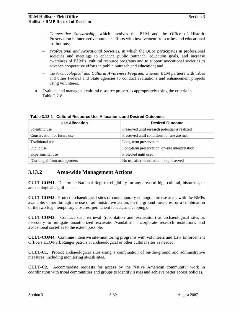
BLM Hollister Field Office Section 3 Hollister RMP Record of Decision
– Cooperative Stewardship, which involves the BLM and the Office of Historic Preservation in interpretive outreach efforts with involvement from tribes and educational institutions;
– Professional and Avocational Societies, in which the BLM participates in professional societies and meetings to enhance public outreach, education goals, and increase awareness of BLM’s cultural resource programs and to support avocational societies to advance cooperative efforts in public outreach and education; and
– the Archaeological and Cultural Awareness Program, wherein BLM partners with tribes and other Federal and State agencies to conduct evaluations and enhancement projects using volunteers.
• Evaluate and manage all cultural resource properties appropriately using the criteria in Table 2.2-8.
Table 3.13-1 Cultural Resource Use Allocations and Desired Outcomes Use Allocation Desired Outcome
Scientific use Preserved until research potential is realized Conservation for future use Preserved until conditions for use are met Traditional use Long-term preservation Public use Long-term preservation, on-site interpretation Experimental use Protected until used Discharged from management No use after recordation; not preserved
3.13.2 Area-wide Management Actions
CULT-COM1. Determine National Register eligibility for any areas of high cultural, historical, or archaeological significance.
CULT-COM2. Protect archaeological sites or contemporary ethnographic-use areas with the BMPs available, either through the use of administrative action, on-the-ground measures, or a combination of the two (e.g., temporary closures, permanent fences, and capping).
CULT-COM3. Conduct data retrieval (recordation and excavation) at archaeological sites as necessary to mitigate unauthorized excavation/vandalism; incorporate research institutions and avocational societies to the extent possible.
CULT-COM4. Continue intensive site-monitoring programs with volunteers and Law Enforcement Officers LEO/Park Ranger patrols at archaeological or other cultural sites as needed.
CULT-C1. Protect archaeological sites using a combination of on-the-ground and administrative measures, including monitoring at-risk sites.
CULT-C2. Accommodate requests for access by the Native American community; work in coordination with tribal communities and groups to identify issues and achieve better access policies.
Section 3 3-30 August 2007

BLM Hollister Field Office Section 3 Hollister RMP Record of Decision
CULT-C3. Promote opportunities with academic, professional, and avocational groups and institutions for anthropological, archaeological, and ethnographic studies.
CULT-C4. Physically protect all known archaeological sites and Native American use areas with demonstrated use conflicts, or avoid through project/route redesign, as appropriate.
3.13.3 San Benito Management Area Actions
CULT-C5. Monitor impacted archaeological sites. Identify and protect Native American use areas.
3.13.4 Central Coast Management Area Actions
CULT-C6. Fence and monitor impacted archaeological sites. Identify and protect Native American use areas.
3.14 Paleontological Resources 3.14.1 Goals and Objectives
Goals for paleontological resources are to (1) preserve, protect and manage vertebrate, noteworthy invertebrate, and plant paleontological resources in accordance with existing laws and regulations for current and future generations; (2) facilitate the appropriate scientific, educational, and recreational uses of paleontological resources such as research and interpretation; (3) accommodate permit requests for scientific research by qualified individuals or institutions; (4) ensure that proposed land uses do not destroy or damage paleontological resources.
To achieve the goals for paleontological resources, the following objectives are established:
• Using predictive modeling, identify significant localities that may be in conflict with other resource uses;
• Foster public awareness and appreciation of paleontological resources through educational outreach programs.
3.14.2 Area-wide Management Actions
PALEO-COM1. Accommodate permit requests for scientific research by qualified individuals or institutions; these are issued by the California State Office for a maximum of three years to individuals and/or organizations who meet the proper qualifications.
PALEO-COM2. Protect paleontological resources from inadvertent damage or destruction from proposed land uses. 3.14.3 San Joaquin Management Area Actions
PALEO-C1. Establish a 300-foot buffer for project actions around all paleontological sites and localities.
Section 3 3-31 August 2007

BLM Hollister Field Office Section 3 Hollister RMP Record of Decision
PALEO-C2. Install temporary fences along margins of pad sites on oil and gas developments to eliminate off-site project-related vehicle impacts on undisturbed areas; initiate site-specific mitigation, if necessary, through contract studies if significant sites cannot be avoided.
PALEO-C3. Stabilize and/or recover significant fossil resources that may be threatened by natural erosion.
3.15 Social and Economic Conditions 3.15.1 Goals and Objectives
The goal for social and economic conditions is to manage public lands to provide social and economic benefits to local residents, businesses, visitors, and future generations.
To achieve the goals for social and economic conditions the following objectives are established:
• Work cooperatively with private and community groups and local tribal governments to provide for customary uses consistent with other resource objectives and to sustain or improve local economies.
• Maintain and promote the cultural, economic, ecological, and social health of communities associated with BLM public lands.
3.15.2 Area-wide Management Actions
SOCEC-C1. Through cooperative and collaborative processes, make contracts and cooperative agreements for services and products available locally when need and conditions permit.
SOCEC-C2. Protect and conserve natural values except that BLM would provide for sustainable tourism, production, and industry.
SOCEC-C3. Work collaboratively with local populations to emphasize a high level of natural resource protection, which contributes to tourism and attracts sustainable commodities industries.
SOCEC-C4. Emphasize sustainable economic operations while protecting the ecological, social, and cultural integrity of BLM public lands.
3.16 Transportation and Access
3.16.1 Goals and Objectives
The goals for transportation and access are to (1) maintain roads for administrative purposes; (2) support local counties and the State of California in providing a network of roads for movement of people, goods, and services across public lands; and (3) manage motorized access use to protect resource values, promote public safety, provide responsible motorized access use opportunities where appropriate, and minimize conflicts among various user groups.
To achieve the goals for transportation and access the following objectives are established:
Section 3 3-32 August 2007
BLM Hollister Field Office Section 3 Hollister RMP Record of Decision
• Provide travel routes to and through BLM-managed lands as appropriate to meet resource objectives while providing for private and public access needs.
• Manage motorized access and mechanized vehicle use in conformance with OHV designations.
3.16.2 Area-wide Management Actions
TRANS-COM1. Public vehicle use on all BLM lands would be limited to designated routes, except as noted. As outlined in the IMP and wilderness legislation, WSAs and Wilderness Areas would be closed to vehicle use, except on designated pre-existing vehicle ways.
TRANS-COM2. Complete route maintenance and improvement work in accordance with implementation standards and references from the following sources:
• BLM Manuals 9113, H-9113-2, and 9114
• Federal Highway Administration (FHWA) Standard Specifications for Construction of Roads and Bridges on Federal Highway Projects Standards
• U.S. Forest Service Trails Handbook 2309.18 (Section 2.32 (a)(b)(c))
TRANS-C1. Reclaim redundant road systems or roads that no longer serve their intended purpose to protect sensitive resources, reduce sediment transport, and control erosion.
TRANS-C2. Implement BMPs to reduce off-site water quality impacts from roads and trails that no longer serve their original purpose or exceed state soil loss standards.
TRANS-C3. Temporarily close roads to vehicle use during periods of extreme wet weather in areas where sustained vehicle use may compromise the integrity of the road surface.
TRANS-C4. Mitigate or relocate travel routes that traverse riparian areas or cross critical habitat, and occupied or potential habitat, of special status species.
TRANS-C6. Designate routes, as shown on Figures 17 through 21.
3.16.3 Central Coast Management Area Actions
TRANS-COM3. Limit motorized access to street-legal motorized vehicles on Ford Ord Public Lands. Work with local transportation agencies (i.e., Monterey County) for the provisions of public and administrative access north of Eucalyptus Road.
3.16.4 San Joaquin Management Area Actions
TRANS-COM5. Limit vehicle use in the Panoche/Tumey and Griswold Hills to four-wheel drive street-legal vehicles on designated routes from the beginning of upland game season to April 15. Allow foot access all year round.
TRANS-C5. Limit Joaquin Ridge Road to vehicular access for permitted street legal vehicles only.
Section 3 3-33 August 2007

BLM Hollister Field Office Section 3 Hollister RMP Record of Decision
Table 3.16-1 provides an overview of the designated route mileage under the Hollister RMP.
Table 3.16-1 Designated Route Mileage Area Hollister RMP
BLM Lands Excluding Williams Hill, Coalinga Mineral Springs, and Fort Ord Closed 236 Open (County and State Roads) 10 Limited (seasonal closures) 73 Williams Hill and Coalinga Mineral Springs Closed 21 Open 25 Limited 0 Fort Ord Public Lands Closed 0 Open 0 Limited (to street legal vehicles) 0.25
3.17 Hazardous Materials and Public Safety 3.17.1 Goals and Objectives
The goals for hazardous materials and public safety management are to (1) protect public health and safety and environmental resources by minimizing environmental contamination from past and present land uses (i.e., abandoned mine lands and former military lands) on public lands and BLM-owned and operated facilities; (2) comply with Federal, State, and local hazardous materials management laws and regulations; (3) maintain the health of ecosystems through assessment, cleanup, and restoration of contaminated lands; (4) manage the costs, risks, and liabilities associated with hazardous materials so that the responsible parties and not the government bear the brunt of financial liabilities; and (5) integrate environmental protection and compliance with all environmental statutes into BLM activities.
To achieve the goals for hazardous materials and public safety management the following objectives are established:
• Identify and control imminent hazards or threats to human health and/or the environment from hazardous substances releases on public lands (including abandoned mine lands (AML) sites).
• Reduce hazardous waste produced by BLM activities and from authorized uses of public lands through waste minimization programs that include recycling, reuse, substitution, and other innovative, safe, cost-effective methods of pollution prevention.
• Ensure that authorized activities on public lands comply with applicable Federal, State, and local laws, policies, guidance, and procedures.
Section 3 3-34 August 2007

BLM Hollister Field Office Section 3 Hollister RMP Record of Decision
• Promote working partnerships with states, counties, communities, other Federal agencies, and the private sector to prevent pollution and minimize hazardous waste on public lands.
• Protect visitors from risks associated with AMLs and former military lands having unexploded ordnance from either safety hazards and/or environmental releases of chemicals of concern.
3.17.2 Area-wide Management Actions
HAZ-COM1. Maintain an inventory of hazardous materials sites, including abandoned mine sites, BLM facilities, and former military facilities (i.e., Fort Ord).
HAZ-COM2. Ensure that all BLM-authorized activities comply with Federal, State, and local hazardous materials laws and regulations.
HAZ-COM3. Reduce the use of Federal funds for clean-up of contaminated lands by seeking cost avoidance and/or cost recovery from the legally responsible parties.
HAZ-C1. Evaluate existing trails and roads for sediment production and drainage in areas where naturally occurring asbestos (NOA) is likely to be present.
HAZ-C2. Conduct air analyses to determine the presence and exposure of NOA during common activities in the area.
HAZ-C3. Where NOA is present at hazardous levels, post signs and/or inform users that NOA is present, what the risks are, and how users can avoid exposure.
3.18 Land and Realty 3.18.1 Goals and Objectives
The goal for lands and realty management is to provide lands, interests in land, and authorizations for public and private uses while maintaining and improving resource values and public land administration.
To achieve the goal for lands and realty management, the following objectives are established:
• Retain, consolidate, and/or acquire land or interest in land with high public resource values for effective administration and improvement of resource management;
• Make public land available for disposal that meets the disposal criteria contained in Section 203(a) of the FLPMA;
• Meet public, private, and Federal agency needs for realty-related land use authorizations and land withdrawals, including those authorizations necessary for wind, solar, biomass, and other forms of renewable energy development;
• Acquire legal public or administrative access to public land; and
• Eliminate unauthorized use of public lands.
Section 3 3-35 August 2007

BLM Hollister Field Office Section 3 Hollister RMP Record of Decision
3.18.2 Land Tenure Adjustments
3.18.2.1 Area-wide Management Actions
LTEN-COM1. Prohibit the acquisition of contaminated lands, except for those identified in LTEN-C3 following cleanup under the Comprehensive Environmental Response, Compensation, and Liability Act (CERCLA).
LTEN-COM2. Acquire or exchange lands in accordance with FLPMA and other applicable Federal laws and regulations to ensure more efficient management of the public lands, to reduce conflicts with other public and private landowners, and to provide more consistency and logic in land use patterns within the Hollister Resource Area.
LTEN-COM3. Identify the public lands (noted in Figures 22 through 27) for potential disposal. These lands have been screened and considered for disposal to promote management efficiency. These public lands meet the disposal criteria of FLPMA and other Federal laws and regulations and would not jeopardize management objectives (i.e., disposal would have to be in conformance with the management objectives of the plan).
Prior to any disposal, a site-specific analysis must determine that the lands considered:
• Contain no significant wildlife, recreation, or other resource values the loss of which cannot be mitigated;
• Have no overriding public values;
• Are not within or adjacent to a special designation area; and
• Represent no substantial public investments.
LTEN-COM4. Acquire lands within special management areas, including WSAs and ACECs.
LTEN-C1. Acquire lands with high resource values, including biological resources and recreation opportunities.
Table 3.18-1 Acres Available for Disposal San Joaquin Panoche Hills and Griswold/Tumey Hills 23,445
Ciervo Hill/Joaquin Rocks Coalinga Mineral Springs Coalinga
San Benito Mountain/Hernandez Valley 6,027
Gabilans/Diablo Salinas Sierra de Salinas 16,840
Parkfield Williams Hill
Central Coast Scattered Tracts 264
3.18.2.2 Central Coast Management Area Actions
Section 3 3-36 August 2007

BLM Hollister Field Office Section 3 Hollister RMP Record of Decision
LTEN-COM5. Retain all offshore islands and maintain the protective withdrawal for the California Coastal National Monument.
LTEN-C2. Fort Ord Public Lands – Retain lands transferred from the Army to the BLM under a Memorandum of Understanding (MOU) with the Army and Transfer Agreements as part of the Base Realignment and Closure Act (BRAC). Consider minor boundary adjustments (less than 50 acres) for existing developed lands through sale, exchange, or other means to facilitate management efficiency.
LTEN-C3. Fort Ord Public Lands – Acquire and retain additional lands from the Army through transfer following cleanup under CERCLA. Consider acquiring other lands from willing sellers to augment the management efficiency of the Fort Ord Public Lands.
LTEN-C5. Other Acquisition Areas – Consider acquiring additional lands within the Central Coast Management Area from willing sellers to enhance the appreciation and management efficiency of the California Coastal National Monument or to contribute to the fulfillment of resource management goals and objectives.
3.18.2.3 Salinas Management Area Actions
LTEN-C6. A stipulation on BLM public lands available for disposal in the Sierra de Salinas would prioritize potential interested parties in the following order:
(1) The State in which the land is located; (2) Local government entities in such State that are in the vicinity of the land; (3) Adjoining landowners; (4) Individuals; and (5) Any other person.
3.18.2.4 San Joaquin Management Area Actions
LTEN-C7. A stipulation on BLM public lands that are subject to the USFWS Recovery Plan for Upland Species of the San Joaquin Valley (1997) would only be available for disposal in exchange for occupied and/or high quality habitat of the target species of the Recovery Plan.
3.18.3 Land Use Authorizations
3.18.3.1 Area-wide Management Actions
LUSE-COM1. Lands identified for retention are considered unsuitable for entry under any of the agricultural land laws because of significant multiple-use values.
LUSE-COM2. Place special emphasis on resolution of unauthorized uses of public lands. Increase coordination with local, State and other Federal law enforcement agencies.
LUSE-COM3. Maintain consistency with County General Plans and zoning within BLM policy.
LUSE-COM4. Consider use authorizations and permits on a case-by-case basis.
Section 3 3-37 August 2007
BLM Hollister Field Office Section 3 Hollister RMP Record of Decision
LUSE-C1. Consider expanding existing communication sites and utility corridors to meet the needs of the state and local communities.
3.18.3.2 Central Coast Management Area Actions
LUSE-COM6. Honor valid existing rights and easements that have been acquired through land acquisitions. Serialize and enter into the automated record all rights-of-way, easements, or other third-party authorizations.
LUSE-C2. Fort Ord – Consider requests for new right-of-way and/or construction of utility sites and related facilities on a case-by-case basis. Restrict proposed uses that require the conversion of natural lands to development-oriented uses to less than 2 percent of BLM holdings at Fort Ord. This 2 percent development restriction would apply to BLM developments (i.e., roads, trails, parking areas, etc.) as well and would exclude habitat.
Consider constructing up to two additional towers and related support buildings on the Wildcat Communication Site once transferred from the Army to BLM.
3.18.3.3 San Joaquin Management Area Actions
LUSE-COM7. Expand the U.S. Interstate 5 utility corridor on the western boundary to include the Path 15 transmission line and the San Luis water pipeline, but exclude the Panoche North and South WSAs.
Section 3 3-38 August 2007

BLM Hollister Field Office Hollister RMP Record of Decision Section 4
4.0 ADMINISTRATIVE REVIEW AND APPEALS
The goals, objectives, and management actions management outlined in Section 3 of this Record of Decision (ROD) that replace the 1984 Hollister Resource Management Plan (RMP), as amended, are not appealable to the Interior Board of Land Appeals. All protests on the Hollister Field Office Proposed RMP and Final Environmental Impact Statement (EIS) have been resolved, and the decision of the BLM Director is the final decision of the Department of the Interior (43 CFR 1610.5-2).
The decisions designating routes of travel for motorized vehicles are an implementation decisions and are appealable under 43 CFR Part 4. These decisions are contained in Appendix A of the RMP (Figures 17-22). The appeal procedures are summarized below.
4.1 APPEALS
The route designations, as described in Appendix A of the RMP, are effective upon issuance of this Record of Decision, unless a stay of the decision is granted. In accordance with 43 CFR 8342.3(b), public notice was provided with publication in the Federal Register of a Notice of Availability of the Proposed RMP and Final EIS and with a Notice of Availability of this Record of Decision.
Any party adversely affected by the proposed route designations may appeal within 30 days of receipt of this decision in accordance with the provisions of 43 CFR Part 4.4. The publication of the Notice of Availability of this ROD will be considered the date the decision is received. The appeal should state the specific route(s), as identified in Appendix A of the RMP, on which the decision is being appealed. The appeal must be filed with the Field Manager, at the following address:
Hollister Field Office 20 Hamilton Court Hollister, CA 95023
You may include a statement of reasons when the notice of appeal is filed, or you may file the statement of reasons within 30 days after filing the appeal. A copy of the appeal, statement of reasons, and all other supporting documents must also be sent to the Solicitor, U.S. Department of the Interior, 2800 Cottage Way, Suite E-1712, Sacramento 95825.
If the Statement of reasons is filed separately, it must be sent to the Interior Board of Land Appeals, Office of Hearings and Appeals, 801 N. Quincy Street, Suite 300, Arlington, VA 22203. It is suggested that any appeal be sent certified mail, return receipt requested.
Section 4 4-1 August 2007

BLM Hollister Field Office Hollister RMP Record of Decision Section 4
If you wish to request a stay of the decision pending the outcome of the appeal, the motion for stay must be filed in the office of the authorized officer at the time the appeal is filed and must show sufficient justification based on the following standards under 43 CFR 4.21:
1. The relative harm to the parties if the stay is granted or denied.
2. The likelihood of the appellant’s success on the merits.
3. The likelihood of immediate and irreparable harm if the stay is not granted.
4. Whether the public interest favors granting the stay.
4.2 CONTACT INFORMATION
For more information, please call the Hollister Field Office at (831) 630-5000.
Section 4 4-2 August 2007

BLM Hollister Field Office Hollister RMP Record of Decision Section 5
5.0 LIST OF PREPARERS
This Record of Decision for the Hollister Resource Management Plan and the associated environmental impacts statements were prepared by an interdisciplinary team of resource specialist from the BLM Hollister Field Office. Ecology and Environment, Inc. (E & E), an environmental consulting firm in San Francisco, California, assisted the BLM in the preparation of these documents and in the planning process.
BLM Staff Contractor Project • George Hill, Field Office Manager, HFO • Ron Karpowicz, P.E., Management • Sky Murphy, NEPA Coordinator, HFO
• Eliseo Ilano, Planning and Environmental Coordinator, California State Office
Project Manager, E & E) • Colin Moy, Resource
Leader, E & E • Bill Richards, Resource
Leader, E & E • Elke Rank, Resource
Leader, E & E Air Quality • Tim Moore, Physical Scientist, HFO • Bruce Wattle, Air and Noise
Specialist, E & E Biological • Bruce Delgado, Botanist, HFO • Noreen Roster, Biologist, Resources • Julie Anne Delgado, Botanist, HFO
• Gary Diridoni, Wildlife Biologist , HFO E & E
• Jerry Barker, Rangeland and Fire Management Specialist, E & E
• Adrienne Fink, Ecologist, E & E
Cultural and • Erik Zaborsky, Archeologist, HFO • Leslie Fryman, Heritage Archaeologist, Albion Resources Environmental Inc.
• Matthew Brickley, Anthropologist, Albion Environmental Inc.
Energy and • Tim Moore, Physical Scientist, HFO • Ralph Lambert, R.G., Minerals • Jeff Prude, Petroleum Engineer,
Bakersfield Field Office • Larry Vredenburgh, GIS Specialist,
Bakersfield Field Office
Geologist, E & E • Bill Richards,
Environmental Scientist, E & E
Fire Management • Mario Marquez, Fire Management Officer, HFO
• Jerry Barker, Rangeland and Fire Management Specialist, E & E
Hazardous Materials and Public Safety
• Tim Moore, Physical Scientist, HFO • Steve Morin, Engineer, E & E
Lands and Realty • Dan Byrne, Realty Specialist/ Property Clerk, HFO
• Colin Moy, Environmental Scientist, E & E
Paleontological Resources
• Erik Zaborsky, Archeologist, HFO • Jessica Spiegel, Geologist E & E
Section 5 1 August 2007

BLM Hollister Field Office Hollister RMP Record of Decision Section 5
BLM Staff Contractor Rangeland Resources
• Bruce Cotterill, Range Conservationist, HFO
• Diana Brink, California State Office
• Jerry Barker, Rangeland and Fire Management Specialist, E & E
Recreation • Lesly Smith, Outdoor Recreation Planner, HFO
• Eric Morgan, Fort Ord Project Manager, HFO
• Elke Rank, Environmental Planner, E & E
Social and • George Hill, Assistant Field Manager, • Steve Moore, Socio-Economic HFO Economist, Burro Canyon
Enterprises, LLC • Elke Rank, Environmental
Planner, E & E Soil Resources • Tim Moore, Physical Scientist, HFO • Ralph Lambert, R.G. ,
Geologist, E & E Special Designations
• Lesly Smith, Outdoor Recreation Planner Sky Murphy, NEPA Coordinator, HFO
• Maureen O’Shea-Stone, Ecologist, E & E
Transportation • Lesly Smith, Outdoor Recreation Planner, • Angela Glenn, Recreation and Access HFO
• Eric Morgan, Fort Ord Project Manager, HFO
Planner, E & E • Elke Rank, Environmental
Planner, E & E Visual Resource Management
• Lesly Smith, Outdoor Recreation Planner, HFO
• Debbie Linton, Visual Resource Specialist, E & E
Water Resources • Tim Moore, Physical Scientist, HFO • Jessica Spiegel, Geologist E & E
• Bill Richards, Environmental Scientist, E & E
GIS/Mapping • Eric Wergeland, GIS Specialist, HFO • Al Hanson, GIS Specialist, E & E
Section 5 2 August 2007

Hollister Field Office Appendix B Resource Management Plan
Appendix B Wild & Scenic River Inventory
I. Wild and Scenic River System
The Wild and Scenic Rivers Act of 1968 (Public Law 90-542) was passed by Congress to preserve riverine systems that contain outstanding features. The law was enacted during an era when many rivers were being dammed or diverted, and is intended to balance this development by ensuring that certain rivers and streams remain in their free-flowing condition. The BLM is mandated to evaluate stream segments on public lands as potential additions to the National Wild and Scenic Rivers System (NWSRS) during the Resource Management Plan (RMP) Process under Section 5(d) of the Act. The NWSRS study guidelines are found in BLM Manual 8351, U.S. Departments of Agriculture and Interior Guidelines published in Federal Register Vol. 7, No.173, September 7, 1982 and in various BLM memoranda and policy statements. Formal designation as a Wild and Scenic River requires Congressional Legislation, or designation can be approved by the Secretary of Interior if nominated by the Governor of the state containing the river segment. The following discussion provides information on how BLM considered waterways for potential inclusion in the NWSRS.
The NWSRS study process has three distinct steps:
1. Determine what rivers or river segments are eligible for NWSRS designation;
2. Determine the potential classification of eligible river segments as wild, scenic, recreational or any combination thereof; and
3. Conduct a suitability study to determine if the river segments are suitable for designation as components of the NWSRS.
This report documents all three steps of the process for the streams in the planning area.
II. Eligibility of Planning Area Rivers & Streams
Identification
A variety of sources were reviewed to identify waterways which could have potential for wild and scenic river designation. They include the Nationwide Rivers Inventory List, the Outstanding Rivers List compiled by American Rivers, Inc., river segments identified by state or local government, river segments identified by the public during formulation of the Hollister Resource Management Plan, and river segments identified by the planning team as having potential to meet Wild and Scenic River eligibility requirements.
The Wild and Scenic Rivers Act defines a river as a “flowing body of water or estuary or a section, portion, or tributary thereof, including rivers, streams, creeks, runs, kills, rills, and small lakes.”
Fifteen stream segments totaling 77 miles located on or crossing BLM public lands were identified for review. Some streams were divided into segments, based on land status, or classification criteria (see paragraph on classification).These rivers are listed in Table 1: Wild & Scenic River Inventory.
B-1

Hollister Field Office Appendix B Resource Management Plan
Eligibility Determination
Each identified river segment was evaluated to determine whether it is eligible for inclusion in the NWSRS. To be eligible, a river segment must be “free flowing” and must possess at least one “outstandingly remarkable value” (ORV). These ORV’s include:
• Scenic, • Cultural,
• Recreational, • Ecological,
• Geological, • Riparian,
• Fish, • Botanical,
• Wildlife, • Hydrological, and
• Historical, • Scientific values
To be considered as “outstandingly remarkable”, a river related value must be a unique, rare, or exemplary feature that is significant at a comparative regional or national scale. Only one such value is needed for eligibility. All values should be directly river related, meaning they should:
1. Be located in the river or on its immediate shorelands (generally within ¼ mile on either side of the river);
2. Contribute substantially to the functioning of the river ecosystem; and/or
3. Owe their location or existence to the presence of the river.
These are the only factors considered in determining the eligibility of a river segment. All other relevant factors are considered in determining suitability. A river need not be navigable by watercraft to be eligible. For purposes of eligibility determination, the volume of flow is sufficient if it is enough to maintain the outstandingly remarkable value(s) identified within the segment.
Table 1 summarizes the eligibility evaluation of all identified river segments. The table includes information on the length of stream segments managed by BLM, BLM acreage (including a ¼ mile corridor on either side of the stream), free-flowing status, and outstandingly remarkable value(s) of each eligible segment, if applicable. Table 1 also gives a description of each eligible river segment’s location on BLM Surface Management (SM) maps.
B-2

Hollister Field Office Appendix B Proposed RMP/Final EIS
Table 1: Wild & Scenic River Inventory River Name/Segment Reason Considered (1) BLM Length (mi.) BLM Acres Segment/Reach Identification Free Flowing ORV (2) Eligibility AGUA MALA CREEK C 1.0 3.0 POINT SUR SM, T17S., R4E., SEC 17, 18 Y A Non-eligible
ARROYO LEONA CANYON C 14.5 43.9 COALINGA SM, T18S., R13E., SEC 3, 9, 10, 15, 16, 22, 23 Y A Non-eligible
BLACK ROCK CREEK C 1.5 4.5 POINT SUR SM, T17S., R2E., SEC 33, 34 Y A Non-eligible
CANTUA CREEK 1 C 10.5 63.6 COALINGA SM, T18S., R13E., SEC 3, 4,5,6 T18S., R12E., SEC 1, 12 Y A Non-eligible
CANTUA CREEK 2 C 1.5 9.0 COALINGA SM, T17S., R13E., SEC 36 Y A Non-eligible EL TORO CREEK C 3.8 22.5 MONTEREY SM, T15S., R2E T16S., R2E Y A Non-eligible GRISWOLD CREEK C 1.5 4.5 MENDOTA SM, T 16S., R10E., SEC 12, 13 Y A Non-eligible HEPSEDAM CREEK C 0.8 2.3 COALINGA SM, T18S., R10E., SEC 26 Y A Non-eligible HORSE CANYON C 0.5 1.5 POINT SUR SM, T19S., R5E., SEC 35 Y A Non-eligible
LAGUNA CREEK C 1.8 5.3 COALINGA SM, T18S., R11E., SEC 18, 19 T18S., R10E., SEC 13 N A Non-eligible
MINE CREEK C 0.8 2.3 MENDOTA SM, T13S., R9E., SEC 23, 25, 26 Y A Non-eligible
PANOCHE CREEK C 23.0 138.0 MENDOTA SM, T15S., R12E., SEC 18, 19, 20 T15S., R11E., SEC 13, 14, 22, 23, 24 Y A Non-eligible
SAN BENITO RIVER (non-CCMA) C 0.3 2.7 COALINGA SM, T18S., R10E., SEC 3, 4, 9, 34 N A Non-eligible
SILVER CREEK C 15.0 90.0
MENDOTA SM T16S., R12E., SEC 6, 7, 19, 29 T15S., R12E., SEC 20, 29, 31, 32 T15S., R11E., S24 Y A Non-eligible
SWEETWATER CREEK C 0.5 1.5 POINT SUR SM, T19S., R6E., SEC 31, 32 Y A Non-eligible
SM = BLM Surface Management Map (1) A – National Rivers Inventory
B – 1988 Outstanding Rivers List, American Rivers, Inc. C – Segment in Hollister Field Office riparian database D – Other
(2) A – Non-existent B – Scenic C – Recreational D – Geological E – Fish & Wildlife F – Historical G – Cultural H – Other (including Ecological)
B-3

Hollister Field Office Appendix B Proposed RMP/Final EIS
III. Suitability of Hollister Field Office Stream Segments
No river segments displayed in Table 1 were found to be eligible for inclusion into the NWSRS.
Section 4(a) of the Wild and Scenic River Act mandates that all rivers found eligible as potential additions to the NWSRS be studied as to their suitability for such a designation. The purpose of the suitability study is to provide information upon which the President of the United States can base his recommendation and Congress can make a decision. The study report describes the characteristics that do or do not make the stream segment a worthy addition to the system, the current status of land ownership and use in the area, the reasonably foreseeable potential uses of the land and water which would be enhanced, foreclosed, or curtailed if the area were included in the system, and several other factors. The suitability study is designed to answer these questions:
1. Should the river’s free–flowing character, water quality, and outstandingly remarkable values (ORVs) be protected, or are one or more other uses important enough to warrant doing otherwise?
2. Will the river’s free-flowing character, water quality, and ORVs be protected through designation? Is it the best method for protecting the river corridor? (In answering these questions, the benefits and impacts of wild and scenic river designation must be evaluated, and alternative protection methods considered.)
3. Is there a demonstrated commitment to protect the river by any nonfederal entities that may be partially responsible for implementing protective management?
Pursuant to Sections 4(a) and 5(c) of the Wild and Scenic Rivers Act, the following factors would be considered and evaluated as a basis for the suitability determination for each river (as described further, below);
1. Characteristics that do or do not make the area a worthy addition to the NWSRS;
2. The current status of land ownership, minerals (surface and subsurface), and use in the area, including the amount of private land involved and associated or incompatible uses.
3. The reasonably foreseeable potential uses of the land and water that would be enhanced, foreclosed, or curtailed if the area were included in the NWSRS. Historical or existing rights which could be adversely affected.
4. The federal agency that will administer the area should it be added to the NWSRS.
5. The estimated cost to the United States of acquiring necessary lands and interests in lands and of administering the area should it be added to the NWSRS.
6. A determination of the degree to which the state or its political subdivisions might participate in the preservation and administration of the river should it be proposed for inclusion in the NWSRS.
7. An evaluation of the adequacy of local zoning and other land use controls in protecting the river’s ORVs by preventing incompatible development;
8. Federal, public, state, local, or other interests in designation or non-designation of the river, including the extent to which the administration of the river, including the cost thereof, may be shared by state, local, or other agencies and individuals. Support or opposition to the designation.
9. The consistency of designation with other agency plans, programs or policies and in meeting regional objectives.
10. The contribution to river system or basin integrity.
B-4

Hollister Field Office Appendix B Proposed RMP/Final EIS
11. The ability of BLM to manage the river segments under designation, or ability to protect the river area other than Wild and Scenic designation.
1. Characteristics that Do or Do Not Make the River Segments Worthy Additions to the NWSRS
Stream segments in the Planning Area are located within the California Coast Range and California Trough of the Pacific Border Physiographic Province. This province was used as a basis to determine if the study segments possess characteristics of at least regional significance that would make them worthy additions to the NWSRS. The Coast Range Physiographic Province contains the highest rainfall and density of streams in California. Also, many of these streams provide habitat for anadromous fisheries. There are currently five designated Wild & Scenic Rivers within the province. They include portions of the Smith River, Klamath River, Van Duzen River, the Main Stem & Middle Fork of the Eel River, and the entire South Fork Eel River. This amounts to a total of approximately 150 miles of designated Wild & Scenic River segments in the region. Very few of the eligible river segments within the Planning Area have any outstandingly remarkable values, and when considered in the context of other streams in the region, which may contain these same values to varying levels, the BLM planning team found that some river segments provided below-average to low quality values in this regional context and therefore were not considered to be worthy additions to the system.
In summary, although these values meet the minimum eligibility criteria, when viewed in the context of the California Coastal Range Physiographic Province, the study team determined that these river segments were not of a level of quality to make them worthy additions to the NWSRS.
2. Status of Land Ownership and Current Use
BLM Manual 8351.33A(2), “Wild and Scenic Rivers – Policy and Program Direction for Identification, Evaluation and Management”, states “In situations where there is limited public land (shoreline and adjacent land) administered by the BLM within an identified river study area, it may be difficult to ensure those identified outstandingly remarkable values could be properly maintained and afforded adequate management protection over time. Accordingly, for those situations where the BLM is unable to protect or maintain any identified outstandingly remarkable values, or through other mechanisms (existing or potential), river segments may be determined suitable only if the entity with land use planning responsibility supports the finding and commits to assisting the BLM in protecting the identified river values. An alternative method to consider these segments is for state, local governments or private citizens to initiate efforts under section 2(a)(ii), or a joint study under section 5C of the Wild and Scenic Rivers Act.” Typically, the local county governments have land use planning responsibility for the private lands on these segments. However, BLM has not approached the counties in the Planning Area regarding their support for wild and scenic designation of these segments, since the study team determined that they are not worthy additions to the system.
3. Potential Uses of the Land to be Enhanced or Curtailed by Designation/ Historical or Existing Rights That Could Be Adversely Affected, including Water Resources Projects.
Diversion of additional water from any of the streams during the summer low-flow period could impact outstandingly remarkable values if they are present. Wild and Scenic River designation would not impact current water rights, but could affect future diversions from the streams.
B-5

Hollister Field Office Appendix B Proposed RMP/Final EIS
4. Federal Agency that will Administer Wild & Scenic River Segments
The Bureau of Land Management’s Hollister Field Office would administer all river segments under evaluation should they be included in the NWSRS.
5. Estimated Cost of Acquisition and Administration
There would be a major need to acquire additional lands for Hollister Field Office river segments to be included in the National Wild & Scenic River System. A large number of residential lots and/or agricultural lands would need to be acquired (or placed under conservation easements) in stream corridors to restore their character. There would also be a modest cost associated with developing management plan(s) for all designated streams, and coordination with adjacent private landowners to ensure that their activities would not cause offsite (downstream or downslope) impacts that could potentially affect river values.
6. State or local political subdivision participation in river preservation and management.
During the initial scoping period no government agencies commented or expressed interest specifically in wild and scenic river designation. However, numerous state and Federal agencies have committed funding and effort to protecting river related values on the study segments. For example, the BLM and California Department of Water Resources have funded grants to reduce sediment transport and flooding that result from watershed management activities in the San Joaquin Valley. Plus, BLM works closely with Regional Water Quality Control Districts and EPA to implement TMDL’s of pollutants in rivers and streams within the planning area. In summary, there is already a strong established level of cooperation among Federal, state and local agencies to restore and protect the beneficial uses of streams in the region.
7. Local Zoning and Land Use Planning Adequacy in protecting the river values.
All of the stream segments included in this study are on Federal Lands administered by the BLM and local zoning would not apply. Where the segments cross private lands, most stretches are zoned for livestock, agriculture, and/or residential use. Livestock and argicultural uses at the scales foreseen within the study segments would not be compatible with Wild and Scenic River designation. Furthermore, as the population of California continues to grow, the land base in these watersheds could be developed for residences at a high density level, and Wild and Scenic River designation would not be compatible with this development.
8. Federal, public, state, local or other interests in designation/non-designation of the river. Support or Opposition to the Designation.
A description of other Federal, state and local agency involvement and interest in river management is contained under item 6 above. Residents of the San Joaquin Valley have a long history of active interest in water conservation for flood control and agriculture or livestock use. Although no comments specific to wild and scenic river designation were received during the scoping period, many comments were received regarding protection of river related values including water quality/quantity, anadromous fisheries, and scenic values.
A number of Coordinated Resource Management Planning (CRMP) groups in the region directly support watershed management and restoration efforts that protect and enhance many of the study segments. The
B-6

Hollister Field Office Appendix B Proposed RMP/Final EIS
Arroyo-Pasajero CRMP and Panoche-Silver Creek CRMP are a consortium of local landowners and residents from western Fresno County and the surrounding region that meet regularly to schedule watershed improvement projects and promote stewardship of resources among property owners and managers in the planning area.
9. The consistency of designation with other agency plans, programs or policies and in meeting regional objectives.
Wild and Scenic River designation for most of the study segments would not be consistent with other agency plans and programs for the region. Although, some segments are classified as Riparian Reserves, which are intended to conserve aquatic ecosystems and are compatible with Wild and Scenic River designation.
10.Contribution to River System or Basin Integrity
The contribution of Wild and Scenic River designation to river system or basin integrity in the planning area would be minimal due to the current regulations and existing efforts to conserve water resources for beneficial uses.
11.Management or Protection other than Wild and Scenic River Designation
In the case of river segments that are found not suitable for designation, the Hollister Field Office will continue to manage these streams as integral ecosystem components on BLM public lands. Management objectives in the Hollister RMP call for continued emphasis on restoration of riparian ecosystems, and other components of healthy watersheds. The preferred alternative for this plan also calls for the BLM to submit applications to the State of California for federal water reserves to protect the aquatic habitat of streams on public lands.
Recommendation
It is recommended that none of the eligible river segments identified in this study, as defined in Table 1, be designated as components of the NWSRS.
IV.Protective Management
All river segments found to be eligible for inclusion in the NWSRS are placed under protective management by the BLM. Subject to valid existing rights, the BLM is required to protect the free-flowing characteristics and outstandingly remarkable values in the stream corridors. The BLM must also protect the corridor from modifications that would impact the tentative river classification (I. E. change the classification potential from Wild to Scenic, or from Scenic to Recreational). These management restrictions apply only to public lands. Once suitability is determined and the Record of Decision (ROD) for the RMP signed, protective management continues only for those segments found suitable for designation. This protective management remains in effect until Congress makes a final decision regarding designation, or the Resource Management Plan is amended.
Rationale
Many of the river segments under evaluation have similar land tenure status, historical uses, and potential or existing uses. The primary factor for the non-suitable determination of all river study segments in the planning area was the conclusion that they would not make worthy additions to the system. Many of these watersheds have been substantially modified through past mining and logging activities and the
B-7

Hollister Field Office Appendix B Proposed RMP/Final EIS
associated construction of roads and trails. The resulting landscapes would not broaden the representation of key ecosystems within the Wild and Scenic River system. A second factor contributed to the non-suitable recommendation for river segments near the urban interface. Although these watersheds are currently somewhat undeveloped, local and regional planning demand residential development in these areas to address California’s growing population. The anticipated level of development will change the character of the watersheds and be incompatible with Wild and Scenic River designation. Fisheries and other watershed values for all streams will be afforded protection through state and local land use plans, the Clean Water Act, and the Endangered Species Act.
B-8

Hollister Field Office Appendix C Resource Management Plan
Appendix C Best Management Practices Outlined in the June 2005 Programmatic Environmental Impact Statement on Wind Energy Development on BLM-Administered Lands in the Western United States
The following Best Management Practices (BMPs) will be applied to all wind energy development projects to establish environmentally sound and economically feasible mechanisms to protect and enhance natural and cultural resources. These proposed BMPs were derived from the mitigation measures discussed in Chapter 5 of the Programmatic Environmental Impact Statement (PEIS) but are limited to those measures that are applicable to all wind energy development projects (PEIS Section 5.15). These BMPs would be adopted as required elements of project-specific Plan(s) of Development (PODs) and/or as right-of-way (ROW) authorization stipulations. They are categorized by development activity: site monitoring and testing, development of the POD, construction, operation, and decommissioning. The proposed BMPs for development of the POD identify required elements of the POD needed to address potential impacts associated with subsequent phases of development.
Some of the proposed BMPs address issues that are not unique to wind energy development but that are more universal in nature, such as road construction and maintenance, wildlife management, hazardous materials and waste management, cultural resource management, and pesticide use and integrated pest management. For the most part, however, the level of detail provided by the BMPs is less specific than that provided in other, existing BLM program-specific mitigation guidance documents (PEIS Section 3.6.2). As required by proposed policy (PEIS Section 2.2.3.1), mitigation measures identified in or required by these existing program-specific guidance documents would be applied, as appropriate, to wind energy development projects; however, they are not discussed in detail in the programmatic BMPs proposed here.
In summary, stipulations governing specific wind energy projects would be derived from a number of sources: (1) the proposed BMPs discussed in this section; (2) other, existing and relevant program-specific mitigation guidance (PEIS Section 3.6); and (3) the mitigation measures discussed in PEIS Chapter 5. Guidelines for applying and selecting project-specific requirements include determining whether the measure would (1) ensure compliance with relevant statutory or administrative requirements, (2) minimize local impacts associated with siting and design decisions, (3) promote postconstruction stabilization of impacts, (4) maximize restoration of previous habitat conditions, (5) minimize cumulative impacts, or (6) promote economically feasible development of wind energy on BLM-administered land.
Site Monitoring and Testing
• The area disturbed by installation of meteorological towers (i.e., footprint) shall be kept to a minimum.
• Existing roads shall be used to the maximum extent feasible. If new roads are necessary, they shall be designed and constructed to the appropriate standard.
• Meteorological towers shall not be located in sensitive habitats or in areas where ecological resources known to be sensitive to human activities (e.g., prairie grouse) are present. Installation of towers shall be scheduled to avoid disruption of wildlife reproductive activities or other important behaviors.
C-1

Hollister Field Office Appendix C Resource Management Plan
• Meteorological towers installed for site monitoring and testing shall be inspected periodically for structural integrity.
Plan of Development (POD) Preparation
General
• The BLM and operators shall contact appropriate agencies, property owners, and other stakeholders early in the planning process to identify potentially sensitive land uses and issues, rules that govern wind energy development locally, and land use concerns specific to the region.
• Available information describing the environmental and sociocultural conditions in the vicinity of the proposed project shall be collected and reviewed as needed to predict potential impacts of the project.
• The Federal Aviation Administration (FAA)-required notice of proposed construction shall be made as early as possible to identify any air safety measures that would be required.
• To plan for efficient use of the land, necessary infrastructure requirements shall be consolidated wherever possible, and current transmission and market access shall be evaluated carefully.
• The project shall be planned to utilize existing roads and utility corridors to the maximum extent feasible, and to minimize the number and length/size of new roads, lay-down areas, and borrow areas.
• A monitoring program shall be developed to ensure that environmental conditions are monitored during the construction, operation, and decommissioning phases. The monitoring program requirements, including adaptive management strategies, shall be established at the project level to ensure that potential adverse impacts of wind energy development are mitigated. The monitoring program shall identify the monitoring requirements for each environmental resource present at the site, establish metrics against which monitoring observations can be measured, identify potential mitigation measures, and establish protocols for incorporating monitoring observations and additional mitigation measures into standard operating procedures and BMPs.
• “Good housekeeping” procedures shall be developed to ensure that during operation the site will be kept clean of debris, garbage, fugitive trash or waste, and graffiti; to prohibit scrap heaps and dumps; and to minimize storage yards.
Wildlife and Other Ecological Resources
• Operators shall review existing information on species and habitats in the vicinity of the project area to identify potential concerns.
• Operators shall conduct surveys for federal- and/or state-protected species and other species of concern (including special status plant and animal species) within the project area and design the project to avoid (if possible), minimize, or mitigate impacts to these resources.
• Operators shall identify important, sensitive, or unique habitats in the vicinity of the project and design the project to avoid (if possible), minimize, or mitigate impacts to these habitats (e.g., locate the turbines, roads, and ancillary facilities in the least environmentally sensitive areas; i.e., away from riparian habitats, streams, wetlands, drainages, or critical wildlife habitats).
• The BLM will prohibit the disturbance of any population of federal listed plant species.
C-2

Hollister Field Office Appendix C Resource Management Plan
• Operators shall evaluate avian and bat use of the project area and design the project to minimize or mitigate the potential for bird and bat strikes (e.g., development shall not occur in riparian habitats and wetlands). Scientifically rigorous avian and bat use surveys shall be conducted; the amount and extent of ecological baseline data required shall be determined on a project basis.
• Turbines shall be configured to avoid landscape features known to attract raptors, if site studies show that placing turbines there would pose a significant risk to raptors.
• Operators shall determine the presence of bat colonies and avoid placing turbines near known bat hibernation, breeding, and maternity/nursery colonies; in known migration corridors; or in known flight paths between colonies and feeding areas.
• Operators shall determine the presence of active raptor nests (i.e., raptor nests used during the breeding season). Measures to reduce raptor use at a project site (e.g., minimize road cuts, maintain either no vegetation or nonattractive plant species around the turbines) shall be considered.
• A habitat restoration plan shall be developed to avoid (if possible), minimize, or mitigate negative impacts on vulnerable wildlife while maintaining or enhancing habitat values for other species. The plan shall identify revegetation, soil stabilization, and erosion reduction measures that shall be implemented to ensure that all temporary use areas are restored. The plan shall require that restoration occur as soon as possible after completion of activities to reduce the amount of habitat converted at any one time and to speed up the recovery to natural habitats.
• Procedures shall be developed to mitigate potential impacts to special status species. Such measures could include avoidance, relocation of project facilities or lay-down areas, and/or relocation of biota.
• Facilities shall be designed to discourage their use as perching or nesting substrates by birds. For example, power lines and poles shall be configured to minimize raptor electrocutions and discourage raptor and raven nesting and perching.
Visual Resources
• The public shall be involved and informed about the visual site design elements of the proposed wind energy facilities. Possible approaches include conducting public forums for disseminating information, offering organized tours of operating wind developments, and using computer simulation and visualization techniques in public presentations.
• Turbine arrays and turbine design shall be integrated with the surrounding landscape. Design elements to be addressed include visual uniformity, use of tubular towers, proportion and color of turbines, nonreflective paints, and prohibition of commercial messages on turbines.
• Other site design elements shall be integrated with the surrounding landscape. Elements to address include minimizing the profile of the ancillary structures, burial of cables, prohibition of commercial symbols, and lighting. Regarding lighting, efforts shall be made to minimize the need for and amount of lighting on ancillary structures.
Roads
• An access road siting and management plan shall be prepared incorporating existing BLM standards regarding road design, construction, and maintenance such as those described in the BLM 9113 Manual (BLM 1985) and the Surface Operating Standards for Oil and Gas Exploration and Development (RMRCC 1989) (i.e., the Gold Book).
C-3

Hollister Field Office Appendix C Resource Management Plan
Ground Transportation
• A transportation plan shall be developed, particularly for the transport of turbine components, main assembly cranes, and other large pieces of equipment. The plan shall consider specific object sizes, weights, origin, destination, and unique handling requirements and shall evaluate alternative transportation approaches. In addition, the process to be used to comply with unique state requirements and to obtain all necessary permits shall be clearly identified.
• A traffic management plan shall be prepared for the site access roads to ensure that no hazards would result from the increased truck traffic and that traffic flow would not be adversely impacted. This plan shall incorporate measures such as informational signs, flaggers when equipment may result in blocked throughways, and traffic cones to identify any necessary changes in temporary lane configuration.
Noise
• Proponents of a wind energy development project shall take measurements to assess the existing background noise levels at a given site and compare them with the anticipated noise levels associated with the proposed project.
Noxious Weeds and Pesticides
• Operators shall develop a plan for control of noxious weeds and invasive species, which could occur as a result of new surface disturbance activities at the site. The plan shall address monitoring, education of personnel on weed identification, the manner in which weeds spread, and methods for treating infestations. The use of certified weed-free mulching shall be required. If trucks and construction equipment are arriving from locations with known invasive vegetation problems, a controlled inspection and cleaning area shall be established to visually inspect construction equipment arriving at the project area and to remove and collect seeds that may be adhering to tires and other equipment surfaces.
• If pesticides are used on the site, an integrated pest management plan shall be developed to ensure that applications would be conducted within the framework of BLM and DOI policies and entail only the use of EPA-registered pesticides. Pesticide use shall be limited to nonpersistent, immobile pesticides and shall only be applied in accordance with label and application permit directions and stipulations for terrestrial and aquatic applications.
Cultural/Historic Resources
• The BLM will consult with Indian Tribal governments early in the planning process to identify issues regarding the proposed wind energy development, including issues related to the presence of cultural properties, access rights, disruption to traditional cultural practices, and impacts to visual resources important to the Tribe(s).
• The presence of archaeological sites and historic properties in the area of potential effect shall be determined on the basis of a records search of recorded sites and properties in the area and/or, depending on the extent and reliability of existing information, an archaeological survey. Archaeological sites and historic properties present in the area of potential effect shall be reviewed to determine whether they meet the criteria of eligibility for listing on the National Register of Historic Places (NRHP).
• When any ROW application includes remnants of a National Historic Trail, is located within the viewshed of a National Historic Trail’s designated centerline, or includes or is within the
C-4

Hollister Field Office Appendix C Resource Management Plan
viewshed of a trail eligible for listing on the NRHP, the operator shall evaluate the potential visual impacts to the trail associated with the proposed project and identify appropriate mitigation measures for inclusion as stipulations in the POD.
• If cultural resources are present at the site, or if areas with a high potential to contain cultural material have been identified, a cultural resources management plan (CRMP) shall be developed. This plan shall address mitigation activities to be taken for cultural resources found at the site. Avoidance of the area is always the preferred mitigation option. Other mitigation options include archaeological survey and excavation (as warranted) and monitoring. If an area exhibits a high potential, but no artifacts were observed during an archaeological survey, monitoring by a qualified archaeologist could be required during all excavation and earthmoving in the high-potential area. A report shall be prepared documenting these activities. The CRMP also shall (1) establish a monitoring program, (2) identify measures to prevent potential looting/vandalism or erosion impacts, and (3) address the education of workers and the public to make them aware of the consequences of unauthorized collection of artifacts and destruction of property on public land.
Paleontological Resources
• Operators shall determine whether paleontological resources exist in a project area on the basis of the sedimentary context of the area, a records search for past paleontological finds in the area, and/or, depending on the extent of existing information, a paleontological survey.
• If paleontological resources are present at the site, or if areas with a high potential to contain paleontological material have been identified, a paleontological resources management plan shall be developed. This plan shall include a mitigation plan for collection of the fossils; mitigation could include avoidance, removal of fossils, or monitoring. If an area exhibits a high potential but no fossils were observed during survey, monitoring by a qualified paleontologist could be required during all excavation and earthmoving in the sensitive area. A report shall be prepared documenting these activities. The paleontological resources management plan also shall (1) establish a monitoring program, (2) identify measures to prevent potential looting/vandalism or erosion impacts, and (3) address the education of workers and the public to make them aware of the consequences of unauthorized collection of fossils on public land.
Hazardous Materials and Waste Management
• Operators shall develop a hazardous materials management plan addressing storage, use, transportation, and disposal of each hazardous material anticipated to be used at the site. The plan shall identify all hazardous materials that would be used, stored, or transported at the site. It shall establish inspection procedures, storage requirements, storage quantity limits, inventory control, nonhazardous product substitutes, and disposition of excess materials. The plan shall also identify requirements for notices to federal and local emergency response authorities and include emergency response plans.
• Operators shall develop a waste management plan identifying the waste streams that are expected to be generated at the site and addressing hazardous waste determination procedures, waste storage locations, waste-specific management and disposal requirements, inspection procedures, and waste minimization procedures. This plan shall address all solid and liquid wastes that may be generated at the site.
• Operators shall develop a spill prevention and response plan identifying where hazardous materials and wastes are stored on site, spill prevention measures to be implemented, training requirements, appropriate spill response actions for each material or waste, the locations of spill
C-5

Hollister Field Office Appendix C Resource Management Plan
response kits on site, a procedure for ensuring that the spill response kits are adequately stocked at all times, and procedures for making timely notifications to authorities.
Storm Water
• Operators shall develop a storm water management plan for the site to ensure compliance with applicable regulations and prevent off-site migration of contaminated storm water or increased soil erosion.
Human Health and Safety
• A safety assessment shall be conducted to describe potential safety issues and the means that would be taken to mitigate them, including issues such as site access, construction, safe work practices, security, heavy equipment transportation, traffic management, emergency procedures, and fire control.
• A health and safety program shall be developed to protect both workers and the general public during construction, operation, and decommissioning of a wind energy project. Regarding occupational health and safety, the program shall identify all applicable federal and state occupational safety standards; establish safe work practices for each task (e.g., requirements for personal protective equipment and safety harnesses; Occupational Safety and Health Administration [OSHA] standard practices for safe use of explosives and blasting agents; and measures for reducing occupational electric and magnetic fields [EMF] exposures); establish fire safety evacuation procedures; and define safety performance standards (e.g., electrical system standards and lightning protection standards). The program shall include a training program to identify hazard training requirements for workers for each task and establish procedures for providing required training to all workers. Documentation of training and a mechanism for reporting serious accidents to appropriate agencies shall be established.
• Regarding public health and safety, the health and safety program shall establish a safety zone or setback for wind turbine generators from residences and occupied buildings, roads, ROWs, and other public access areas that is sufficient to prevent accidents resulting from the operation of wind turbine generators. It shall identify requirements for temporary fencing around staging areas, storage yards, and excavations during construction or decommissioning activities. It shall also identify measures to be taken during the operation phase to limit public access to hazardous facilities (e.g., permanent fencing would be installed only around electrical substations, and turbine tower access doors would be locked).
• Operators shall consult with local planning authorities regarding increased traffic during the construction phase, including an assessment of the number of vehicles per day, their size, and type. Specific issues of concern (e.g., location of school bus routes and stops) shall be identified and addressed in the traffic management plan.
• If operation of the wind turbines is expected to cause significant adverse impacts to nearby residences and occupied buildings from shadow flicker, low-frequency sound, or EMF, site-specific recommendations for addressing these concerns shall be incorporated into the project design (e.g., establishing a sufficient setback from turbines).
• The project shall be planned to minimize electromagnetic interference (EMI) (e.g., impacts to radar, microwave, television, and radio transmissions) and comply with Federal Communications Commission [FCC] regulations. Signal strength studies shall be conducted when proposed locations have the potential to impact transmissions. Potential interference with public safety communication systems (e.g., radio traffic related to emergency activities) shall be avoided.
C-6

Hollister Field Office Appendix C Resource Management Plan
• The project shall be planned to comply with FAA regulations, including lighting regulations, and to avoid potential safety issues associated with proximity to airports, military bases or training areas, or landing strips.
• Operators shall develop a fire management strategy to implement measures to minimize the potential for a human-caused fire.
Construction
General
• All control and mitigation measures established for the project in the POD and the resource-specific management plans that are part of the POD shall be maintained and implemented throughout the construction phase, as appropriate.
• The area disturbed by construction and operation of a wind energy development project (i.e., footprint) shall be kept to a minimum.
• The number and size/length of roads, temporary fences, lay-down areas, and borrow areas shall be minimized.
• Topsoil from all excavations and construction activities shall be salvaged and reapplied during reclamation.
• All areas of disturbed soil shall be reclaimed using weed-free native grasses, forbs, and shrubs. Reclamation activities shall be undertaken as early as possible on disturbed areas.
• All electrical collector lines shall be buried in a manner that minimizes additional surface disturbance (e.g., along roads or other paths of surface disturbance). Overhead lines may be used in cases where burial of lines would result in further habitat disturbance.
• Operators shall identify unstable slopes and local factors that can induce slope instability (such as groundwater conditions, precipitation, earthquake activities, slope angles, and the dip angles of geologic strata). Operators also shall avoid creating excessive slopes during excavation and blasting operations. Special construction techniques shall be used where applicable in areas of steep slopes, erodible soil, and stream channel crossings.
• Erosion controls that comply with county, state, and federal standards shall be applied. Practices such as jute netting, silt fences, and check dams shall be applied near disturbed areas.
Wildlife
• Guy wires on permanent meteorological towers shall be avoided.
• In accordance with the habitat restoration plan, restoration shall be undertaken as soon as possible after completion of construction activities to reduce the amount of habitat converted at any one time and to speed up the recovery to natural habitats.
• All construction employees shall be instructed to avoid harassment and disturbance of wildlife, especially during reproductive (e.g., courtship and nesting) seasons. In addition, pets shall not be permitted on site during construction.
C-7

Hollister Field Office Appendix C Resource Management Plan
Visual Resources
• Operators shall reduce visual impacts during construction by minimizing areas of surface disturbance, controlling erosion, using dust suppression techniques, and restoring exposed soils as closely as possible to their original contour and vegetation.
Roads
• Existing roads shall be used, but only if in safe and environmentally sound locations. If new roads are necessary, they shall be designed and constructed to the appropriate standard and be no higher than necessary to accommodate their intended functions (e.g., traffic volume and weight of vehicles). Excessive grades on roads, road embankments, ditches, and drainages shall be avoided, especially in areas with erodible soils. Special construction techniques shall be used, where applicable. Abandoned roads and roads that are no longer needed shall be recontoured and revegetated.
• Access roads and on-site roads shall be surfaced with aggregate materials, wherever appropriate.
• Access roads shall be located to follow natural contours and minimize side hill cuts.
• Roads shall be located away from drainage bottoms and avoid wetlands, if practicable.
• Roads shall be designed so that changes to surface water runoff are avoided and erosion is not initiated.
• Access roads shall be located to minimize stream crossings. All structures crossing streams shall be located and constructed so that they do not decrease channel stability or increase water velocity. Operators shall obtain all applicable federal and state permits.
• Existing drainage systems shall not be altered, especially in sensitive areas such as erodible soils or steep slopes. Potential soil erosion shall be controlled at culvert outlets with appropriate structures. Catch basins, roadway ditches, and culverts shall be cleaned and maintained regularly.
Ground Transportation
• Project personnel and contractors shall be instructed and required to adhere to speed limits commensurate with road types, traffic volumes, vehicle types, and site-specific conditions, to ensure safe and efficient traffic flow and to reduce wildlife collisions and disturbance and airborne dust.
• Traffic shall be restricted to the roads developed for the project. Use of other unimproved roads shall be restricted to emergency situations.
• Signs shall be placed along construction roads to identify speed limits, travel restrictions, and other standard traffic control information. To minimize impacts on local commuters, consideration shall be given to limiting construction vehicles traveling on public roadways during the morning and late afternoon commute time.
Air Emissions
• Dust abatement techniques shall be used on unpaved, unvegetated surfaces to minimize airborne dust.
• Speed limits (e.g., 25 mph [40 km/h]) shall be posted and enforced to reduce airborne fugitive dust.
C-8

Hollister Field Office Appendix C Resource Management Plan
• Construction materials and stockpiled soils shall be covered if they are a source of fugitive dust.
• Dust abatement techniques shall be used before and during surface clearing, excavation, or blasting activities.
Excavation and Blasting Activities
• Operators shall gain a clear understanding of the local hydrogeology. Areas of groundwater discharge and recharge and their potential relationships with surface water bodies shall be identified.
• Operators shall avoid creating hydrologic conduits between two aquifers during foundation excavation and other activities.
• Foundations and trenches shall be backfilled with originally excavated material as much as possible. Excess excavation materials shall be disposed of only in approved areas or, if suitable, stockpiled for use in reclamation activities.
• Borrow material shall be obtained only from authorized and permitted sites. Existing sites shall be used in preference to new sites.
• Explosives shall be used only within specified times and at specified distances from sensitive wildlife or streams and lakes, as established by the BLM or other federal and state agencies.
Noise
• Noisy construction activities (including blasting) shall be limited to the least noise-sensitive times of day (i.e., daytime only between 7 a.m. and 10 p.m.) and weekdays.
• All equipment shall have sound-control devices no less effective than those provided on the original equipment. All construction equipment used shall be adequately muffled and maintained.
• All stationary construction equipment (i.e., compressors and generators) shall be located as far as practicable from nearby residences.
• If blasting or other noisy activities are required during the construction period, nearby residents shall be notified in advance.
Cultural and Paleontological Resources
• Unexpected discovery of cultural or paleontological resources during construction shall be brought to the attention of the responsible BLM authorized officer immediately. Work shall be halted in the vicinity of the find to avoid further disturbance to the resources while they are being evaluated and appropriate mitigation measures are being developed.
Hazardous Materials and Waste Management
• Secondary containment shall be provided for all on-site hazardous materials and waste storage, including fuel. In particular, fuel storage (for construction vehicles and equipment) shall be a temporary activity occurring only for as long as is needed to support construction activities.
• Wastes shall be properly containerized and removed periodically for disposal at appropriate off-site permitted disposal facilities.
• In the event of an accidental release to the environment, the operator shall document the event, including a root cause analysis, appropriate corrective actions taken, and a characterization of the
C-9

Hollister Field Office Appendix C Resource Management Plan
resulting environmental or health and safety impacts. Documentation of the event shall be provided to the BLM authorized officer and other federal and state agencies, as required.
• Any wastewater generated in association with temporary, portable sanitary facilities shall be periodically removed by a licensed hauler and introduced into an existing municipal sewage treatment facility. Temporary, portable sanitary facilities provided for construction crews shall be adequate to support expected on-site personnel and shall be removed at completion of construction activities.
Public Health and Safety
• Temporary fencing shall be installed around staging areas, storage yards, and excavations during construction to limit public access.
Operation
General
• All control and mitigation measures established for the project in the POD and the resource-specific management plans that are part of the POD shall be maintained and implemented throughout the operational phase, as appropriate. These control and mitigation measures shall be reviewed and revised, as needed, to address changing conditions or requirements at the site, throughout the operational phase. This adaptive management approach would help ensure that impacts from operations are kept to a minimum.
• Inoperative turbines shall be repaired, replaced, or removed in a timely manner. Requirements to do so shall be incorporated into the due diligence provisions of the ROW authorization. Operators will be required to demonstrate due diligence in the repair, replacement, or removal of turbines; failure to do so could result in termination of the ROW authorization.
Wildlife
• Employees, contractors, and site visitors shall be instructed to avoid harassment and disturbance of wildlife, especially during reproductive (e.g., courtship and nesting) seasons. In addition, any pets shall be controlled to avoid harassment and disturbance of wildlife.
• Observations of potential wildlife problems, including wildlife mortality, shall be reported to the BLM authorized officer immediately.
Ground Transportation
• Ongoing ground transportation planning shall be conducted to evaluate road use, minimize traffic volume, and ensure that roads are maintained adequately to minimize associated impacts.
Monitoring Program
• Site monitoring protocols defined in the POD shall be implemented. These will incorporate monitoring program observations and additional mitigation measures into standard operating procedures and BMPs to minimize future environmental impacts.
• Results of monitoring program efforts shall be provided to the BLM authorized officer.
C-10

Hollister Field Office Appendix C Resource Management Plan
Public Health and Safety
• Permanent fencing shall be installed and maintained around electrical substations, and turbine tower access doors shall be locked to limit public access.
• In the event an installed wind energy development project results in EMI, the operator shall work with the owner of the impacted communications system to resolve the problem. Additional warning information may also need to be conveyed to aircraft with onboard radar systems so that echoes from wind turbines can be quickly recognized.
Decommissioning
General
• Prior to the termination of the ROW authorization, a decommissioning plan shall be developed and approved by the BLM. The decommissioning plan shall include a site reclamation plan and monitoring program.
• All management plans, BMPs, and stipulations developed for the construction phase shall be applied to similar activities during the decommissioning phase.
• All turbines and ancillary structures shall be removed from the site.
• Topsoil from all decommissioning activities shall be salvaged and reapplied during final reclamation.
• All areas of disturbed soil shall be reclaimed using weed-free native shrubs, grasses, and forbs.
• The vegetation cover, composition, and diversity shall be restored to values commensurate with the ecological setting.
C-11

THIS PAGE INTENTIONALLY LEFT BLANK

Hollister Field Office Appendix D Resource Management Plan
Appendix D Oil and Gas Stipulations
Management Guidance that Applies to all Alternatives
The following stipulations and conditions would apply to new leases issued in the resource area under all alternatives. These conditions would also be applied to new operations on existing leases as conditions of approval for Applications for Permit to Drill (APD) or geophysical exploration permits.
1. Measures to Protect Threatened, Endangered, and Other Special Status Species
A) BLM Standard Lease Stipulations (BLM Form 3100-11).
These provisions require the operator to minimize impacts to biological resources, take reasonable measures required by the BLM to protect resources, conduct minor inventories or short term special studies, contact the BLM if threatened or endangered species are observed, and cease operations that would result in the destruction of threatened or endangered species. Reasonable measures are defined in 43 CFR 3101.1-2 as consistent with lease rights if, at a minimum, they do not require relocation of operations more than 200 meters, require siting of facilities off the lease, or prohibit surface disturbing operations more than 60 days in any lease year.
B) Prior to authorization of any surface disturbing activity a review of existing ecological data would be conducted to determine if any threatened, endangered, or other special status species may exist on the proposed site. If this review indicates species of concern may occur on the site, then a site-specific field examination would be conducted during the appropriate season to determine if the species occupies the site. Field surveys would be conducted by qualified botanists following the standards established by the California Department of Fish and Game (2000) and the California Native Plant Society (revised from Nelson 1987, approved by CNPS Board on June 2, 2001, included in CNPS 2001). If species occur, then all surface disturbing activity would be moved up to 200 meters and/or prohibited for up to 60 days in any lease year to avoid adverse impacts to the species. If movement of the site this distance or these seasonal restrictions were insufficient to avoid impacts, then additional mitigation measures would be develop din conjunction with consultations with the U.S. Fish & Wildlife Service per Section 7 of the Endangered Species Act. Similar procedures would also be used to avoid adverse impacts to state-listed species, with appropriate measures developed in concert with the California Department of Fish & Game regional managers.
Guidelines for Assessing the Effects of Proposed Projects on Rare, Threatened, and Endangered Plants and Natural Communities, Department of Fish and Game, December 9, 1983, Revised May 8, 2000.
CNPS Botanical Survey Guidelines, California Native Plant Society, December 9, 1983, Revised June 2, 2001.
D-1

Hollister Field Office Appendix D Resource Management Plan
C) Specialized habitats such as riparian areas, vernal pools, other wetlands, floodplains, native perennial grasses, saltbrush, and oak woodlands would be avoided by surface disturbing activities when practical and feasible alternatives exist.
D) Measures included in the Panoche/Coalinga ACEC Plan (1987) to mitigate oil and gas exploration and development activities would be implemented in all areas within the resource area where potential or occupied habitat for these species occurs. These measures would also be applied to T&E plant habitat as appropriate. (These measures are included as Management Actions in Chapter 2 of this RMP/EIS under ACEC–A3 through ACEC–A27).
E) A stipulation prohibiting surface occupancy within ½ mile of raptor nest sites during nesting and fledgling seasons would be placed on all leases that include known raptor nest sites. The seasonal prohibition could be waived if field examination indicated the nest site was not being used.
2. Measures to Protect Scenic Quality (Visual Resources)
A) BLM Standard Lease Stipulations (BLM Form 3100-11).
The operator is required to take reasonable measures to minimize impacts to visual resources. Reasonable measures are defined in 43 CFR 3101.1-2 to include, but not limited to, modification of design or siting of facilities, and relocation of proposed operations by up to 200 meters.
3. Measures to Protect Water Quality
A) BLM Standard Lease Stipulations (BLM Form 3100-11).
The operator is required to take reasonable measures to minimize impacts to land, air, and water resources. Such measures include, but are not limited to, specifications of interim and final reclamation measures.
B) Standards and guidelines in the Surface Operating Standards for Oil and Gas Exploration and Development (RMRCC 1989) would be applied to all oil and gas exploration and development activities. These are interagency guidelines developed to provide design and construction techniques and other practices that would minimize surface disturbance, effects on other resources, and maintain reclamation on potential of lease sites.
C) Proposed oil and gas development proposals (pad/access road construction, vegetation removal, etc.) on slopes that exceed 10%, within the selenium-bearing Moreno shale formation would require submission of designs prepared by a licensed professional engineer, incorporating adequate mitigation measures to preclude slope failure or off-site sediment transport of sediments and detailing reclamation procedures that would result in successful restoration and revegetation of the site.
D-2

Hollister Field Office Appendix D Resource Management Plan
4. Measures to Protect Cultural Resources
A) BLM Standard Lease Stiplations (BLM Form 3100-11).
The operator is required to minimize impacts to cultural resources, take reasonable measures required by the BLM to protect resources, conduct minor inventories or short term special studies, contact the BLM if objects of historic or scientific interest are observed, and cease operations that would result in destruction of historic objects. Reasonable measures are defined in 43 Code of Federal Regulations 3101.1-2 as consistent with lease rights if, at a minimum, they do not require relocation of operations more than 200 meters or require siting of facilities off the lease.
B) A cultural resource inventory would be required prior to authorization of any surface disturbing activity. Proposed activities would be moved up to 200 meters to avoid adverse impacts to all potentially significant archaeological sites. For sites that could not be avoided, an appropriate data recovery plan would be developed in consultation with the State Historic Preservation Officer and the National Advisory Council on Historic Preservation. Implementation of the data recovery plan would be a condition of approval of the proposed activity.
5. Measures to Protect Air Quality
A) All oil and gas exploration and development activities that require off-road vehicle use or surface disturbance would be required to obtain an air quality emission permit or verification that such permits are not appropriate from the regional air quality control board.
B) All oil and gas exploration and development activities resulting in surface disturbance or requiring the use of motorized vehicles would be required to suppress fugitive dust emissions from paved and unpaved surfaces in accordance with local APCD regulations.
Selection of the Proposed Actions and Associated Mitigation Measures
All lands with potential for oil and gas development would be identified for leasing , with more than 65% of the resource area identified for leasing subject to standard terms and conditions only. Where stipulations were applied to leases, less restrictive measures would be carefully considered in lieu of stipulations. Less restrictive measures would not provide an appropriate level of protection for environmental resources. Wherever prudent and consistent with appropriate protection of environmental resources, information notices would be used in lieu of lease stipulations. Information notices may be used to assure that potential bidders would be aware of special considerations that affect operations on prospective leases.
D-3
Hollister Field Office Appendix D Resource Management Plan
The use of No Surface Occupancy (NSO) stipulations have been limited to relatively small areas where directional drilling could occur off-site without impacting similar resource values that the NSO is designed to protect.
An Endangered Species Stipulation has been applied to endangered plant species habitat. The use of this stipulation clearly establishes that when protection of a listed species conflicts with exploration or development of the lease, then protection of the species shall prevail. Less restrictive measures did not provide this assurance. Development of new oil and gas fields in T&E animal species habitat would be limited to disturbance of 10% of the habitat within the lease area. This level of disturbance is compatible with maintenance of high-quality habitat for these species. BLM anticipates a continued cooperative effort between the oil and gas industry, the BLM, the U.S. Fish & Wildlife Service, and California Department of Fish & Game to develop and refine procedures that allow for continuation of oil and gas activities without jeopardizing the survival of these endangered species.
Requirements that all lease activities on federal lands be permitted by the Regional Air Quality Control Districts would assure that all practical and reasonable measures to resolve air quality degradation are being implemented.
While the imposition of these Measures to protect elements of the environment from unnecessary and undue degradation could affect some individual oil and gas operators, it is not expected to have a significant impact on the overall level of domestic oil and gas exploration and development.
Additional Mitigation Measures
A) Air modeling studies per the requirements of the Monterey Bay Unified Air Pollution Control District Rule 207 would be required before any emissions are allowed on leases in the Pinnacles National Monument.
B) Destruction of potential T&E habitat would require acquisition and transfer to the BLM of comparable off-site habitat. If suitable lands are not available for purchase, establishment of trust funds for future purchase of mitigation lands could be made in lieu of land purchases.
C) Exploratory drilling in T&E plant or animal habitat would be required to use self- contained units to eliminate the need for sumps and to minimize spillage.
D) Development of new oil and gas fields in T&E animal species habitat would be limited to disturbance of 10% of the habitat within the lease area.
E) Exploratory wells would be moved at least 200 meters from wildlife water sources.
F) Off-site mitigation would be required if development activities in newly discovered field results in loss of Santa Lucia deer herd habitat.
D-4
Hollister Field Office Appendix D Resource Management Plan
G) Wherever practical and consistent with other objectives, abandonment procedures would attempt to restore native vegetation and natural appearing contours.
H) Where site-specific evaluation indicates exploratory well sites would be valuable wildlife water resources, conditions would be applied requiring operators to provide the BLM with the option to develop unsuccessful wells for wildlife water. Priority for allocation of new water sources would be to enhance wildlife habitat.
I) Site-specific conditions for well abandonment operations with T&E animal or plant habitat would give priority to maintaining and/or establishing habitat for these species.
J) Within blunt-nosed leopard lizard and San Joaquin antelope ground squirrel habitat, road berms would be avoided during road maintenance and construction with burrows hand excavated to allow animals to escape prior to destruction of the berms.
K) Wherever practical, access roads would be constructed on slopes not visible from the major road corridors.
L) Except within the intensively developed areas of existing oil fields, all new facilities would be painted to blend in with the surrounding natural landscape.
M) To prevent contamination of surface waters during flood events, oil sump construction and storage of oil in oil well cellars would not be permitted in floodplains.
Monitoring
A) Table D-1 summarizes items to be monitored, impact thresholds which will trigger subsequent actions, and actions to be taken if thresholds are exceeded.
B) Specifically the following will comprise BLM’s monitoring strategy.
1) Monitoring will be conducted by BLM staff.
2) Results will be conveyed to other concerned agencies when significant adverse impacts have occurred or, when significant adverse impacts are absent, a report would be submitted to the USFWS and the CA DFG upon request.
3) All known populations of listed plant species will be visited annually and population size, area, vigor, and reproductive success will be measured or sampled following methods established by species experts and researchers.
4) All areas where surface disturbing activities have been authorized will be visited annually to assess if unexpected impacts are occurring.
D-5

Hollister Field Office Appendix D Resource Management Plan
5) Oil fields under production will be visited twice annually to ensure unauthorized disturbances have not occurred.
C) A moratorium would be placed on leasing within affected areas if the environmental assessment prompted by the monitoring plan indicates that unanticipated significant impacts could result from continuation of the leasing program. The moratorium would remain in effect until a new Environmental Impact Statement is completed.
D-6

Hollister Field Office Appendix D Resource Management Plan
Table D-1. Hollister Oil & Gas Monitoring Plan
ENVIRONMENTAL ELEMENT
ITEM MONITORED THRESHOLD ACTION IF THRESHOLD IS EXCEEDED
AIR QUALITY # of exploratory wells # of new producing wells # of wells abandoned Total new annual emissions
No increase of 20 wells in San Joaquin basin, or net increase of five wells in N. Central Coast basin, or new emissions = 80% of emissions forecast for a basin
Complete new environmental analysis & consult with appropriate air quality control board
SPECIAL STATUS PLANTS Annual inventory of known T&E locations in or near existing or future oil activities following CDFG and CNPS procedures
Any damage to occupied habitats or reduction in population size attributable to human disturbance
Develop new mitigation measures to preclude additional damage
# of acres of habitat disturbed Acres impacted limited to 10% of habitat within lease area or as determined by consultation with the appropriate resource agency and specific resource of concern
Complete new environmental assessment and consult with USFWS
SPECIAL STATUS ANIMALS
Annual monitoring of T&E species in or near existing or future oil activities following ACEC procedures
Any damage to burrows, or reduction in population size attributable to human disturbance
Develop new mitigation measures to preclude additional damage
# of acres of habitat disturbed Acres impacted limited to 10% of habitat within lease area or as determined by consultation with the appropriate resource agency and specific resource of concern
Complete new environmental assessment and consult with USFWS
VISUAL RESOURCES Visually impacted acres visible from I-5
Acres impacted limited to 10% of resource within lease area or as determined by consultation with the appropriate resource agency and specific resource of concern
Complete new environmental assessment
D-7

Hollister Field Office Appendix D Resource Management Plan
Table D-1. Hollister Oil & Gas Monitoring Plan
ENVIRONMENTAL ELEMENT
ITEM MONITORED THRESHOLD ACTION IF THRESHOLD IS EXCEEDED
WILDLIFE Acres of upland game or Santa Lucia deer herd habitat disturbed
Acres impacted limited to 10% of habitat within lease area for either deer or upland game or as determined by consultation with the appropriate resource agency and specific resource of concern
Complete new environmental assessment
WATER QUALITY AND EROSION
Total acres disturbed Acres disturbed (minus acres successfully rehabilitated) limited to 10% of resource within lease area or as determined by consultation with the appropriate resource agency and specific resource of concern
Complete new environmental assessment
OIL & GAS RESOURCES Price and demand for oil No increase of 20 wells in San Joaquin basin or net increase of five wells in N. Central Coast basin
Complete new environmental assessment
Note: Thresholds for actions have generally been set at 80% of impacts anticipated in the Hollister O&G EIS (1993). This allows for sufficient lag time to allow completion of new environmental assessments before impacts in excess of those anticipated in the EIS occur.
D-8

Hollister Field Office Appendix D Resource Management Plan
Endangered Species Stipulation
All or part of the lands within the 273,724 acres of BLM managed lands and 588,197 acres of split estate are within the range of one or more of the taxa identified and/or endangered species listed in the US Fish and Wildlife Service (FWS) Biological Opinion (1-8-07-F-19) for the Hollister RMP/EIS (2007). The BLM manager, through an environmental review process, and the USFWS, through an ESA Section 7 comprehensive biological opinion, have determined that the action is not likely to jeopardize the continued existence of T&E species or result in the destruction or adverse modification of T&E critical habitat.
Therefore, prior to any surface disturbance activities, or even the use of vehicles off existing roads on a lease, BLM approval is required. This restriction also applies to geophysical activities for which a permit is required. The approval is contingent upon the results of site-specific inventories of the listed T&E species in the critical areas of concern. The lessee is hereby notified that the process is likely to take longer than the normal review process and that surface activity approval may be delayed.
If no T&E species are found during the inventories, then no formal Section 7 consultation with the USFWS would be necessary and the action will be processed using the standard Onshore Oil and Gas Order Number 1 Approval of Operations (43 CRF Part 3160, W0-610-411H12-24 1A) procedures [48 FR 48916 as amended in 48 FR 56226 (1983) and proposed rule in 70 FR 43349, July 27, 2005]. However, the lessee is hereby notified that, if T&E species are found during the inventories, the surface disturbing activities may be prohibited on portions of, or even all of the lease, unless an alternative is available that meets all of the following criteria: (a) the proposed action is not likely to jeopardize the continued existence of the T&E species, (b) the proposed action is not likely to destroy or adversely modify critical habitat for the T&E species, and (c) the proposed actions are consistent with USFWS recovery plans and/or BLM resource management plans. This denial authority will also apply to directional drilling proposals which require federal approval to drill into the leased mineral estate from adjacent lands.
D-9

THIS PAGE INTENTIONALLY LEFT BLANK

Hollister Field Office Appendix E Resource Management Plan
Appendix E Special Status Species Information
1. PLANTS
Adobe sanicle – Sanicula maritime Adobe sanicle is not Federally listed, but was listed as Rare under the California Endangered Species Act (CESA) in 1981. This member of the carrot family (Apiaceae) is found in wet to dry clay soils of coastal prairie and coastal sage scrub plant communities. Though there are historic records from San Francisco, its distribution is centered in the coastal hills of San Luis Obispo and Monterey counties and is known to occur in the Hollister Field Office (HFO) Central Coast Management Area.
Antioch Dunes evening primrose – Oenothera deltoids, var. howelii Antioch Dunes evening primrose was listed as Endangered under the CESA in November 1978, Endangered under the Endangered Species Act (ESA) in August 1978, and has federally designated critical habitat.1 This perennial herb is a member of the evening-primrose family (Onagraceae) and grows in loose sand and semi-stabilized dunes. It is located in a small area along the San Joaquin River near Antioch in Contra Costa County and is protected by the San Francisco Bay National Wildlife Refuge and Pacific Gas & Electric (PG&E). A reservoir of moving sand is essential to maintain the dynamic ecology of the dunes and it is degraded by fire control activities, off-highway vehicle (OHV) use, and invasion by exotic species. The most recent population trend for Antioch Dunes evening primrose is one of increase
Beach layia – Layia carnosa Beach layia was listed as Endangered under the ESA in June 1992 and Endangered under the CESA in January 1990. It is a succulent annual herb and sunflower relative (Asteraceae) that occurs on semi-stabilized sand in sparse coastal dune scrub vegetation. This plant is known to occur on five dune systems along the California coastline: in northern Santa Barbara County, on the Monterey Peninsula, at Point Reyes in Marin County, and in two dune systems in Humboldt County.
Threats include residential development, trampling, OHVs, and encroachment by non-native plants. The United States Fish and Wildlife Service (USFWS) completed a recovery plan for beach layia and six other coastal plants in 1998.
Ben Lomond spineflower – Chorizanthe pugens, var. hartwegiana Ben Lomond spineflower was listed as Endangered under the ESA and is not listed under the CESA. It is a short-lived annual herb in the buckwheat family (Polygonaceae) found on sandy Zayante soils that are the basis for the Ben Lomond sandhill communities in the Santa Cruz Mountains. It is found in open areas within northern maritime chaparral and within the scattered ponderosa pines in the sand parklands. The best populations are found on ridgelines where underlying fossilized sand dollar beds inhibit the growth of all but herbaceous perennials and annuals.
Seventeen populations occur within the area generally bounded by the communities of Ben Lomond, Glenwood, Scotts Valley, and Felton, with one outlying population occurring in the Bonny Doon area, 5 miles west of Felton, and one population at Quail Hollow Ranch County Park.
1 "Critical habitat" is defined as the specific area occupied by a species that contains physical or biological features essential to the conservation of the species and that may require special management considerations or protection.
E-1

Hollister Field Office Appendix E Resource Management Plan
Historical and continuing threats to the Ben Lomond spineflower include the direct removal of habitat by sand quarrying and residential development. Alteration of habitat may also be occurring in the form of increased canopy density within the Ben Lomond sandhills as a result of fire suppression.
Butterworth’s buckwheat – Eriogonum butterworthianum Butterworth’s buckwheat was listed Rare under the CESA in 1979 and is not listed under the ESA. It is a woody perennial herb in the buckwheat family (Polygonaceae) and resides in dry sandstone outcrops and crevices within chaparral or mixed evergreen forests in the Santa Lucia Mountains near the headwaters of the Arroyo Seco River in Monterey County. The four known occurrences of this species are on United States Forest Service (USFS) land.
Cattle have continued to graze throughout the habitat, without apparent damage to Butterworth's buckwheat populations. Little information is available on the ecology or population biology of this species. Updated surveys and a management plan are needed. There is a lack of information regarding the trend of this species, but it may be one of stability due to lack of significant threats.
California jewelflower – Caulanthus californicus California jewelflower was listed as Endangered under the CESA in January, 1987 and Endangered under the ESA on July 19, 1990. This annual herb was once found over much of the southern San Joaquin Valley floor. Experimental reintroductions have occurred in Kern, Santa Barbara, and Tulare counties, but all have failed. Taylor (Fremontia 16(1):18-19 (1988) provides a species account.
California jewelflower is known to occur on Hollister Field Office San Joaquin Management Area – Southern Section lands in the Kreyenhagen Hills region of western Fresno County. Agricultural conversion of suitable habitat resulted in a loss of suitable habitat and greatly restricted its known range.
California seablite – Suaeda californica California seablite was listed as Endangered under the ESA on July 19, 1990 and is not listed under the CESA. It is an evergreen shrub restricted to the upper intertidal zone of a coastal salt marsh along the perimeter of a bay. The only known extant plants are discontinuously distributed in a narrow intertidal band around Morro Bay in San Luis Obispo County, California.
The foreseeable threat with the greatest impact is habitat degradation/loss; other threats include anything that alters the topographic gradient or hydrologic conditions of the marsh, including increased sedimentation of the Bay, dredging projects, bluff erosion, and recreation. The plant's restricted range and limited number of individuals also threaten it with extinction due to random events.
Coastal dunes milkvetch – Astragalus tener, var. titi Coastal dunes milkvetch was listed as Endangered under the ESA in June 1998 and Endangered under the CESA in 1982. It is an annual plant in the pea family (Fabaceae), grown in moist depressions on clay soils in coastal terrace grasslands and in coastal strand vegetation on sand dunes. Only one population, on the Monterey Peninsula, has been located in recent years, and numbers fluctuate greatly from year to year in response to local rainfall and competition with native and non-native species. The population is bisected by a road and is subject to golfing and equestrian activities, some of which are detrimental to the milkvetch.
Contra Costa goldfields – Lasthenia conjugens Contra Costa goldfields was listed as Endangered under the ESA on June 18, 1997 and has Federally designated critical habitat. It is not listed under the CESA. Habitat for Contra Costa goldfields is limited to vernal pools. This annual herb was once scattered and frequent in vernal pool habitat throughout central California, but has become greatly reduced with the decline in available habitat. Contra Costa
E-2

Hollister Field Office Appendix E Resource Management Plan
goldfields is known to occur on vernally wet sites and vernal pools in the Bureau of Land Management (BLM) Hollister Field Office Central Coast Management Area on former Fort Ord.
Contra Costa wallflower – Erysimum capitatum, ssp. angustatum Contra Costa wallflower was listed as Endangered under the ESA in April 1978, Endangered under the CESA in 1978, and has Federally designated critical habitat. This member of the mustard family (Brassicaceae) is a herbaceous biennial herb whose distinctive habitat consists of stabilized interior sand dunes that currently are densely covered with herbs, grasses, and shrubs. Only two populations remain, both at the 70-acre Antioch Dunes along the San Joaquin River, near Antioch in Contra Costa County. The area is mainly protected by the USFWS at Antioch Dunes National Wildlife Refuge and by PG&E on its adjoining property.
Sand mining, industrial development, discing for fire control, and OHV activities have left this wallflower on the verge of extinction. A recovery plan for this species and two other species endemic to the Antioch Dunes, prepared by the USFWS, calls for enhancement of existing populations of Contra Costa wallflower and establishment of new populations within its historic range. PG&E designed and paid for enhancement at the Antioch Dunes, which was conducted by the USFWS. The USFWS is currently preparing a management plan for the Antioch Dunes, with the goal of increasing the viability of Contra Costa wallflower.
Coyote ceanothus – Ceanothus ferrisiae Coyote ceanothus was listed as Endangered under the ESA in February 1995 and is not listed under the CESA. It is an erect evergreen shrub of the buckthorn family (Rhamnaceae) known from only four locations on dry slopes in serpentine chaparral and valley and foothill grassland below 1,000 feet within the Mt. Hamilton Range in Santa Clara County. The existing populations are threatened by residential and recreational development, unauthorized dumping, landfill activities, lack of natural recruitment, the expansion of the Anderson Reservoir spillway, altered fire regimes and grazing. There is some evidence that coyote ceanothus seeds require fire for germination, however, this has not been established.
Delta button celery – Eryngium racemosum Delta button celery was listed as Endangered under the CESA in 1981 and is not listed under the ESA. A member of the carrot family (Apiaceae), it is an herbaceous plant that occurs on clay soils on sparsely vegetated margins of seasonally flooded floodplains and swales. Periodic flooding maintains the species' habitat through sustenance of seasonal wetlands and reduction of competition due to scouring. This species' remaining occurrences are in Merced County along the historical floodplain of the San Joaquin River. Friant Dam on the San Joaquin River and an extensive levee system has greatly reduced the frequency and intensity of flooding of Delta button-celery's floodplain habitat.
Population locations and population characteristics differ in dry and wet years. In dry years, many populations occur only as annual plants. A strong population of plants that were perennial during the drought disappeared during wet years. Successful conservation of the species will require protection and maintenance of habitat with a variety of hydrological regimes.
Dudley’s lousewort – Pedicularis dudleyi Dudley’s lousewort was listed as Rare under the CESA in 1979 and is not listed under the ESA. This perennial herb is a member of the figwort family (Scrophulariaceae) that grows under shaded conditions in the coastal redwood and mixed evergreen forest communities of San Luis Obispo, Monterey, Santa Cruz, and San Mateo counties.
E-3

Hollister Field Office Appendix E Resource Management Plan
Fountain thistle – Cirsium fontinale, var. fontinale Fountain thistle was listed as Endangered under the ESA in February 1995 and Endangered under the CESA in July 1979. It is an herbaceous perennial member of the sunflower family (Asteraceae) that occurs only in the extremely restricted serpentine seeps of the Crystal Springs region, San Mateo County. Trail construction would threaten the plants through direct destruction of the habitat or through modification of hydrologic regimes. Fountain thistle is dependent upon seeps and springs to provide abundant soil moisture, such that any disruption in the flow of water (such as that caused by road, trail, or drain construction) would threaten the plants.
The California Department of Fish and Game (CDFG), in cooperation with the USFWS, conducted a recovery workshop addressing this species in April 1997, and as a result of recommendations made at that meeting, the California Department of Transportation (CALTRANS) and San Francisco Water District (SFWD) have initiated pampas grass control programs to try to prevent further degradation of populations on their property. These eradication efforts will need to continue. Management and recovery actions for the species have been addressed in the USFWS's Recovery Plan for Serpentine Soil Species of the San Francisco Bay Area, finalized in 1998.
Gowen cypress – Cupressus goveniana, ssp. goveniana Gowen cypress was listed as Threatened under the ESA and is not listed under the CESA. It is an evergreen tree that occurs in only two areas of Monterey County, California: Huckleberry Hill, and between San Jose Creek and Gibson Creek. In some areas Gowen cypress is associated with closed-cone coniferous woodlands and closed-cone pine-cypress forests. It is a fire-adapted, fire-dependent species, though fire at the wrong time in the species life cycle could wipe it out. It is confined to poorly drained, acidic, podzolic soils, usually on exposed sites and grows best on the coast.
Gowen cypress seedlings are susceptible to damping-off fungi and highly susceptible to coryneum canker, which can kill trees. Grazing and trampling by livestock are detrimental to seedlings; fire followed by intensive grazing could eliminate a cypress grove.
Hickman’s cinquefoil (Hickman’s Potentilla) – Potentilla hickmanii Hickman’s cinquefoil was listed as Endangered under the ESA in 1998 and Endangered under the CESA in 1979. This herbaceous perennial member of the rose family (Rosaceae) is found in seepage areas and other wet sites in coastal prairies or open forested areas along the central coast. Potentilla hickmanii is currently known from only one location, on the western Monterey Peninsula, in a meadow opening within Monterey pine forest.
This species is threatened by the following: alteration, destruction, and fragmentation of habitat; recreational activities; highway widening; competition with non-native species; and alteration of natural fire cycles. It is also threatened with stochastic extinction due to the small numbers of populations and individuals.
Large-flowered fiddleneck – Amsinckia grandiflora Large-flowered fiddleneck was listed as Endangered under the ESA in May 1985 and has Federally designated critical habitat. It was also listed as Endangered under the CESA in April 1982. It is a hairy annual herb in the borage family (Boraginaceae) whose main habitat is now grazing land. The primary current threat is believed to be competition from non-native, annual grasses; other threats include stochastic extinction due to small numbers of populations, and fluctuations in numbers due to predation by rodents.
At present, only three natural populations are known. These all occur in the Altamont Hills of the Diablo Range. All of the populations, both native and experimental, have experienced dramatic declines in the
E-4

Hollister Field Office Appendix E Resource Management Plan
last three years and in April 2000 the Department of Energy entered into an agreement with the USFWS that designated 160 acres within the Lawrence Livermore National Laboratory (LLNL) Site 300 as the Amsinckia grandiflora Reserve to provide for the survival and recovery of the species.
Marin western flax (Marin dwarf flax) – Hesperolinon congestum Marin western flax was listed as Threatened under the ESA in February 1995 and Threatened under the CESA in 1992. This annual plant in the flax family (Linaceae) is found on serpentine ridges covered with bunchgrass from Marin County to San Mateo County and in a serpentine chaparral association in Marin County. There are now 20 known existing occurrences. Residential development and road and freeway construction have eliminated five of the historically known populations of Marin western flax.
Threats to Marin western flax include residential and recreational development, foot traffic, and competition with non-native species. Serpentine outcrops in the San Francisco Bay area are limited; 20 percent of those outcrops have already been eliminated as plant habitat because of development. The pressure to build more houses, roads, and other facilities for humans is great. Serpentine habitats also have been fragmented by the construction of roads. Habitat fragmentation increases the risks of extinction due to chance events such as fire, flood, landslide, pest or disease outbreaks, severe drought, or other natural or human-caused disaster.
Mason’s lilaeopsis – Lilaeopsis masonii Mason’s lilaeopsis was listed as Rare under the CESA in 1979 and is not listed under the ESA. It is a perennial plant in the carrot family (Apiaceae) that is semi-aquatic and is usually found on saturated clay soils that are regularly inundated by waves and tidal action. Its known distribution extends from the margins of the Napa River in Napa County, east to the channels and sloughs of the Sacramento-San Joaquin Delta in Contra Costa, Solano, Sacramento, Yolo, and San Joaquin counties.
Continuing threats include levee maintenance and construction, widening of Delta channels for water transport, dredging and dumping of spoils, recreation, erosion, and, potentially, changes in water quality in the delta.
Mexican flannel bush – Fremontodendron mexicanum Mexican flannel bush was listed as Endangered under the ESA in February 1998 and Rare under the CESA in 1982. It is a tree-like shrub member of the cacao family (Sterculiaceae), currently restricted to the chaparral and cypress woodland plant community in Cedar Canyon on Otay Mesa in San Diego County, where it grows in the canyon bottoms.
The habitat of Mexican flannelbush is subject to human-caused fires, which may occur too frequently to permit regrowth and reproduction of this chaparral species should the areas supporting the plants be burned. Occurrences of Mexican flannelbush are owned by BLM and private landowners.
Marsh sandwort – Arenaria paludicola Marsh sandwort was listed as Endangered under the ESA on 1993 and as Endangered under the CESA in 1990. It is a perennial herb in the pink family (Caryophyllaceae) that occurs in swamps, freshwater marshes, and other wet areas in widely disjunct localities in California and Washington. Today, the distribution of this species is limited to two locations in San Luis Obispo County on the Nipomo Mesa, and one recently discovered population in Mendocino County. Encroachment of non-native eucalyptus trees and drilling of water wells in the immediate watershed of Black Lake Canyon are serious threats to the continued existence of this species. The population in Mendocino County is in a fairly inaccessible location in Inglenook Fen.
E-5

Hollister Field Office Appendix E Resource Management Plan
The Land Conservancy of San Luis Obispo County has acquired 2 acres in Black Lake Canyon, which include the existing marsh sandwort site and one of the previously occupied marsh sandwort sites; the Land Conservancy has prepared a management plan for the canyon that addresses marsh sandwort. Protection measures for marsh sandwort are included in the USFWS's Recovery Plan for Marsh Sandwort (Arenaria paludicola) and Gambel's watercress (Rorippa gambellii), completed in 1999.
Menzies’ wallflower – Erysimum menziesii, ssp. menziesii Menzies’ wallflower was listed as Endangered under the ESA on June 22, 1992 and as Endangered under the CESA in September 1984. Menzies’ wallflower is a biennial or perennial herb member of the mustard family (Brassicaceae) found on partially stabilized sand dunes. USFWS recognizes three subspecies of Menzies’ wallflower: Menzies’ (Erysimum menziesii, ssp. menziesii), Humboldt Bay wallflower (Erysimum menziesii, ssp. eurekense), and Yadon's wallflower (Erysimum menziesii, ssp. yadonii). The entire distribution is restricted to three coastal dune systems in Humboldt, Mendocino, and Monterey counties.
Urbanization and industrialization of California's coast have eliminated many dune communities, and few undisturbed dune regions remain. Most of the remaining populations on the Humboldt County and Mendocino County coastline are threatened by invasive, non-native species such as ice plant and European beach grass.
Metcalf Canyon jewelflower – Streptanthus albidus, ssp. albidus Metcalf Canyon jewelflower was listed as Endangered under the ESA in February 1995 and is not listed under the CESA. It is an annual herb of the mustard family (Brassicaceae) that only grows on serpentine outcrops with little soil development. It can be locally abundant but its range is limited, extending less than 20 miles from San Jose south to Anderson Lake, which lies northeast of Morgan Hill. Furthermore, the serpentine outcrops on which Metcalf Canyon jewelflower grows are patchily distributed and comprise only a small percentage of the area within its range. It is threatened by trash dumping, residential development, and off-road vehicles.
Monterey clover – Trifolium trichocalyx Monterey clover was listed as Endangered under the ESA in 1998 and as Endangered under the CESA in 1979. This herbaceous annual member of the pea family (Fabaceae) has an extremely limited distribution confined to a small portion of the Monterey Peninsula in the Bishop pine/Monterey pine/pygmy cypress plant community. Nutrient-poor ancient podzol-like soils in this habitat are poorly drained and underlain with hardpan. This species appears in large numbers only after fire burns through its habitat removing the vegetative cover; in the absence of fire, or a reasonable habitat disturbance alternative, this species could become extirpated and potentially rendered extinct.
Monterey Spineflower – Chorizanthe pungens, var. pungens Monterey spineflower was listed under the ESA as Threatened on February 4, 1994 and has Federally designated critical habitat. It is not listed under the CESA. The recovery plan is titled Myrtle's Silverspot Butterfly/Seven Plants.
Monterey spineflower occurs in sandy soils of grasslands, dunes, and maritime chaparral from the Monterey Peninsula to Santa Cruz County. It occurs along roadsides, in firebreaks, and in other disturbed sites. In oak woodland, chaparral, and shrub-scrub communities, the plants occur in sandy openings between shrubs. In older stands with a high cover of shrubs, the plant is restricted to roadside and firebreaks that bisect these communities. This species is known to occur on BLM Hollister Field Office Central Coast Management Area on former Fort Ord.
E-6

Hollister Field Office Appendix E Resource Management Plan
This species is threatened by the following: reduction in habitat and fragmentation due to development and recreational use; dune stabilization due to non-native species introduction; human and equestrian use of habitat and trampling; and road development. This species has been extirpated from locations in the Salinas Valley.
Mt. Diablo bird’s-beak – Cordylanthus nidularius Mount Diablo bird's-beak was listed as Rare under the CESA in February 1978 and is not listed under the ESA. It is an annual member of the figwort family (Scrophulariaceae) that grows in serpentine chaparral. The entire global distribution of this unusual bird's-beak consists of one occurrence on the northeast slope of Mount Diablo in Contra Costa County, within Mount Diablo State Park. This population is stable, although it appears to require some disturbance, such as fire.
Pacific Grove clover – Trifolium polyodon Pacific Grove clover was listed as Rare under the CESA in February 1979 and is not listed under the ESA. It is an annual herb in the pea family (Fabaceae) and occurs in moist grassland areas in the vicinity of the Monterey Peninsula. Competition by weedy native and non-native plants are the main threats.
Pallid manzanita (Alameda manzanita) – Arctostaphylos pallida Pallid manzanita was listed as Threatened under the ESA in April 1998 and as Endangered under the CESA in 1979. A member of the heath family (Ericaceae) and the manzanita chaparral community, it is an evergreen shrub that occurs on east or south facing slopes in pure stands on somewhat sterile mineral soils. It is found primarily at the Sobrante Ridge Preserve and Huckleberry Preserve in Contra Costa and Alameda counties. This plant's habitat has been lost primarily to residential development, and approximately 13 occurrences remain. However, all but three populations on East Bay Regional Parks District (EBRPD) lands are so isolated and small that their long-term viability is questionable.
Significant threats to the species include removal of the plants during construction of fuel breaks and the lack of a natural fire regime; additional threats are shading and competition from native and alien plants. To a lesser extent, the species is threatened by fungal infection, herbicide spraying, hybridization, and the ongoing effects of habitat loss and fragmentation.
Palmate-bracted bird’s-beak – Cordylanthus palmatus Palmate-bracted bird’s-beak was listed as Endangered under the ESA on July 1986 and as Endangered under the CESA in May 1984. It is an annual herb in the figwort family (Scrophulariaceae) confined to saline-alkaline soils and a component of alkali sink scrub vegetation in relatively undisturbed, seasonally flooded lowlands in the Central and Livermore valleys.
The rarity of saline-alkali soils with natural vegetation makes the intensive agricultural and urban development within the species' range the main threat.
Point Reyes meadowflower (Point Reyes meadowfloam) – Limnanthes douglasii, ssp. sulphurea Point Reyes meadowflower was listed as Endangered under the CESA in 1982 and is not listed under the ESA. This herbaceous annual is a member of the false mermaid family (Limnanthaceae) that occurs primarily in vernally moist depressions in open, rolling coastal prairies and meadows. There are 13 occurrences of this species known; 12 of these are within the Point Reyes National Seashore in Marin County, and the other is on private property near Pescadero in San Mateo County. Plant numbers fluctuate widely year to year, and so a general trend is difficult to discern.
Presidio clarkia – Clarkia franciscana Presidio clarkia was listed as Endangered under the ESA on February 3, 1995 and as Endangered under the CESA in November 1978. It is an herbaceous annual member of the evening primrose family
E-7

Hollister Field Office Appendix E Resource Management Plan
(Onagraceae) that occurs on serpentine soils within the coastal prairie grassland community at San Francisco's Presidio and in the Oakland Hills of Alameda County.
The Presidio populations are threatened by habitat degradation. Pedestrian and mountain bicycle traffic on and near trails threatens the habitat. The species is also threatened by road maintenance (mowing) at the Presidio.
Presidio manzanita – Arctostaphylos hookeri, ssp. ravenii Presidio manzanita was listed as Endangered under the ESA on October 26, 1979 and as Endangered under the CESA in November 1978. It is an evergreen shrub member of the heath family (Ericaceae) that grows on shallow, rocky serpentine soils in open areas with some exposure to fog within the Presidio of San Francisco. This taxon has been reduced to a single wild plant plus some clones, which are managed by the National Park Service (NPS). The single wild plant was found in the winter of 1997-98 with a fungal pathogen resulting in approximately 10 percent dieback of branches; as of August 1998, vigorous regrowth had covered over most of the dieback. The plants are protected by fencing and are measured and weeded each year.
Purple amole – Chlorogalum purpureum, var. purpureum Purple amole was listed as threatened under the ESA, has Federally designated critical habitat, and is not listed under the CESA. It is a perennial in the lily family (Liliaceae) with fragmented distribution along the eastern base of the Santa Lucia Mountains of southern Monterey and northern San Luis Obispo counties. This species occurs on thin, rocky to gravelly clay soils of open sites in oak savanna, grasslands, and occasionally chaparral.
Primary threats at Fort Hunter Liggett include loss of plants, habitat alteration, and further fragmentation, all caused by military training activities. Other potential threats include human-caused fires during the late flowering and fruiting season and unauthorized cattle grazing. At Camp Roberts, military training poses a lesser threat, but some sheep grazing may cause trampling. Feral pig activities and competition from noxious weeds pose additional threats in both areas.
Robust spineflower – Chorizanthe robusta, var. robusta Robust spineflower was listed under the ESA as Threatened on February 4, 1994, has Federally designated critical habitat, and is not listed under the CESA. It occurs in sandy soils of grasslands, dunes, and maritime chaparral along the coast and near-coastal areas in Santa Cruz County, and from the Point Reyes National Seashore in Marin County, California. This species is known to occur on the BLM Hollister Field Office Central Coast Management Area on former Fort Ord.
Robust spineflower is threatened by urban development, recreational activities, and competition with nonnative vegetation. In addition, some of the populations contain very low numbers of individuals, which put them at great risk of extinction due to random naturally occurring (stochastic) events.
Rock sanicle – Sanicula saxatilis Rock sanicle was listed as Rare under the CESA in 1982 and is not listed under the ESA. It is a perennial herb in the carrot family (Apiaceae) found on rocky soil, rock outcrops, and talus slopes, usually within the chaparral plant community.
About 10 occurrences of rock sanicle are known. In Contra Costa County, this species occurs on the main and north peaks in Mount Diablo State Park. Several populations along trails there appear stable and receive few impacts from hikers. In Santa Clara County, rock sanicle is known from the vicinity of Mount Hamilton, on privately owned land or on property of the University of California's Lick Observatory, and in remote areas that receive few impacts.
E-8

Hollister Field Office Appendix E Resource Management Plan
San Benito evening primrose – Camissonia benitensis San Benito evening primrose was listed as Threatened under the ESA, and is not listed under the CESA. It is a villous annual herb of the family Onagraceae found only on serpentine alluvial terraces in the San Benito Mountain/Clear Creek region. It grows in loose alluvial soil in openings in chaparral, under the sparse understory of the odd San Benito forest, or in relatively barren deposits of alluvial gravel.
The limited range of this species is subject to gravel mining and disturbance by off-road vehicles (ORVs) and associated use. Mining currently threatens the San Benito evening primrose. Recent designation of the Clear Creek Area of Critical Environmental Concern by the BLM will help to protect major populations of C. benitensis on public land.
San Bruno Mountain manzanita – Arctostaphylos imbricata San Bruno Mountain manzanita was listed as Endangered under the CESA in 1982 and is not listed under the ESA. It is a low evergreen shrub of the heath family (Ericaceae) that forms dense, mat-like colonies on shallow soils derived from Franciscan sandstone, greywacke, or shale. San Bruno Mountain manzanita is known only from the summit of San Bruno Mountain in San Mateo County.
A fungal pathogen infected the plants beginning in about 1997 and caused significant dieback or loss of entire plants. Since then, recovery has been generally good, although some management such as controlled burning may benefit the species.
San Francisco lessingia – Lessingia germanorum San Francisco lessingia was listed as Endangered under the ESA on June 19, 1997 and as Endangered under the CESA in January 1990. A member of the sunflower family (Asteraceae), it is an annual herb that occurs in remnant areas of coastal dune scrub habitat on the San Francisco Peninsula. It appears to require open sandy soils that are relatively free of competing plants.
Damage to lessingia habitat has occurred in the past from trampling by hikers, bikers, and joggers. Ice plant is a direct threat to San Francisco lessingia. In addition, pampas grass is encroaching on lessingia habitat on San Bruno Mountain.
San Francisco popcorn-flower – Plagiobothrys diffusus San Bruno Mountain manzanita was listed as Endangered under the CESA in 1979 and is not listed under the ESA. It is an herbaceous annual member of the borage family (Boraginaceae) found in coastal prairie and vernal pool habitat. It is known from a historic location on the Presidio of San Francisco and from several occurrences in Santa Cruz County and one in northwest San Benito County. The type-locality near Mountain Lake in San Francisco has been altered by landscaping with trees and shrubs and introduced annual grasses, and the popcorn-flower may be extirpated from that site.
This species is vulnerable to disturbance by recreational activities such as horseback riding and biking as well as development.
San Mateo thornmint – Acanthomintha obovata, ssp. duttonii (Acanthomintha duttonii) San Mateo thornmint was listed as Endangered under the ESA on September 18, 1985 and as Endangered under the CESA July 1979. It is an aromatic annual herb of the mint family (Lamiaceae) restricted to serpentine soils of chaparral and valley and foothill grasslands in San Mateo County. The species occupies slopes and flats with deep, heavy clay soil inclusions. The only remaining large population, in Edgewood County Park, is a remnant of a more extensive population damaged by motor vehicle use. Edgewood County Park also contains a small subpopulation. There is an introduced population at Pulgas Ridge.
E-9

Hollister Field Office Appendix E Resource Management Plan
San Mateo thornmint is seriously threatened by urbanization, which extirpated two populations. Road construction may have destroyed a third. The extant populations are threatened by development, off-road vehicles and vandalism.
San Mateo woolly sunflower – Eriophyllum latilobum San Mateo woolly sunflower was listed as Endangered under the ESA on February 3, 1995 and as Endangered under the CESA in June 1992. It is a short-lived herbaceous perennial in the sunflower family (Asteraceae) that occurs in openings in live oak woodland. San Mateo woolly sunflower is a highly restricted endemic whose distribution is limited to several hundred individuals in less than a dozen scattered subpopulations in the Crystal Springs area of San Mateo County.
This species is threatened by many factors. Dumping of garden debris and downhill seepage of pesticides from homeowners living above the population may have a negative impact. The plant also is threatened by competition with non-native plants. The steep slopes along Crystal Springs Road provide a very unstable habitat for San Mateo woolly sunflower. The slopes are subject to erosion and soil slippage. After soil slippage occurs, road maintenance crews remove the slumped soil, which may contain mature individuals, seedlings, and/or seeds. The road cut is then reshaped, which may damage plants remaining on the banks.
Management and recovery actions for the species have been addressed in the USFWS's Recovery Plan for Serpentine Soil Species of the San Francisco Bay Area, finalized in 1998.
Sand (Monterey) Gilia – Gilia tenuiflora, ssp. arenaria Sand Gilia was listed as Endangered under the ESA on June 22, 1992 and as Threatened under the CESA in January 1987. The recovery plan is titled Myrtle's Silverspot Butterfly/Seven Plants.
This member of the phlox family (Polemoniaceae) is an annual herb narrowly endemic to isolated occurrences within wind-sheltered, sparsely vegetated portions of maritime chaparral and coastal dunes on the southerly Monterey Bay and Monterey Peninsula in Monterey County. The subspecies typically grows within coastal dune scrub or Flandrian dune habitat. The Monterey Peninsula populations range from Point Pinos to Point Joe. It is known to occur on the BLM Hollister Field Office Central Coast Management Area on former Fort Ord.
The imminent threat facing this species and its associated habitats is the ongoing and threatened destruction and adverse modification of these dune systems by commercial and residential development, off-road vehicle use, trampling by hikers and equestrians, sand mining, and disposal of dredged material from adjacent bays and waterways. In addition, stochastic events, which commonly adversely affect small isolated populations, may result in the extirpation of some populations of these species.
Santa Clara Valley dudleya – Dudleya setchellii Santa Clara Valley dudleya was listed as Endangered under the ESA on February 3, 1995 and is not listed under the CESA though the CDFG considers it to be "very threatened." It is a low-growing perennial of the stonecrop family (Crassulaceae) that is restricted to rocky outcrops within serpentine grasslands in Santa Clara County. It is found only in the Coyote Valley area, from San Jose south about 20 miles to San Martin, at elevations of 300 to 900 feet.
Santa Clara dudleya always has been restricted to the Coyote Valley area of Santa Clara County. Populations are subject to various levels of threat from development, unauthorized dumping, and off-road vehicle use. The species is also vulnerable because of the horticultural appeal of succulents and the slow growth of the plants. The remaining plants are usually not spectacular in flower but may nonetheless appeal to collectors because of their rarity.
E-10

Hollister Field Office Appendix E Resource Management Plan
Santa Cruz cypress – Cupressus abramsiana Santa Cruz cypress was listed as Endangered under the ESA on 1987 and as Endangered under the CESA in 1979. A member of the cypress family (Cupressaceae), it is a coniferous tree that grows on old marine sandstones or granitic soils in chaparral and closed-cone pine forest communities. This cypress is restricted to a localized area within the Santa Cruz Mountains near Bonny Doon and Eagle Rock in Santa Cruz County. It also occurs at Butano Ridge in San Mateo County. Its distribution suggests that Santa Cruz cypress is a relict species, representing a type of vegetation widespread during glacial times but now confined to scattered sites.
Threats to the populations include competition with non-native species such as broom and pampas grass and the lack of fires to enable reproduction. USFWS released a recovery plan for Santa Cruz cypress in 1998.
Santa Cruz tarplant – Holocarpha macradenia Santa Cruz tarplant was listed as Threatened under the ESA in 1998 and as Endangered under the CESA in 1979. It is an annual herb in the sunflower family (Asteraceae) that occurs in clay soils in grasslands and competes poorly with introduced annual grasses. The species is now limited to 12 natural occurrences in Santa Cruz and Monterey counties.
Management actions such as mowing, raking, hoeing techniques, and fall controlled burns have resulted in increases in the number of tarplants at managed sites.
Santa Cruz (Ben Lomond) wallflower – Erysimum teretifolium Santa Cruz wallflower was listed as Endangered under the ESA on 1994 and as Endangered under the CESA in 1981. A member of the mustard family (Brassicaceae), it is an herbaceous short-lived perennial restricted to inland ponderosa pine sandhills near Felton, Ben Lomond, and Bonny Doon in Santa Cruz County. The habitat, which contains a combination of deep, coarse, and poorly developed dry soils in a relatively humid coastal climate, is rare in California. Distribution of this species is highly correlated with deep sands, which are valuable for mining.
Santa Lucia mint – Pogogyne clareana Santa Lucia mint was listed as Endangered under the CESA in 1979 and is not listed under the ESA. It is an herbaceous annual member of the mint family (Lamiaceae) known only from the tributaries of the Nacimiento River on the Hunter-Liggett Military Reservation in Monterey County. It grows in moist, sandy soil in riparian habitats.
All occurrences on Army land may be vulnerable to livestock grazing, feral pigs, military activities, road maintenance, too frequent fires, trampling, and OHVs, although all known sites seemed to be doing well as of 1998.
Scott’s Valley polygonum (Hickman’s knotweed) – Polygonum hickmanii Scott’s Valley polygonum was listed as Endangered under the ESA and CESA, and has Federally designated critical habitat. It is a taprooted annual in the buckwheat family (Polygonaceae) that occurs on gently sloping to nearly level fine-textured shallow soils over outcrops of Santa Cruz mudstone and Purisima sandstone, at the northern end of Scotts Valley.
Threats to this species include: the present or threatened destruction, modification, or curtailment of its habitat and random extinction due to the small populations of limited distribution.
E-11

Hollister Field Office Appendix E Resource Management Plan
Scotts Valley spineflower – Chorizanthe robusta, var. hartwegii Scotts Valley spineflower was listed as Endangered under the ESA (1994), with the entire Chorizanthe robusta species, has Federally designated critical habitat, and was listed as Endangered under the CESA. It is a short-lived annual species in the buckwheat family endemic to Purisima sandstone and Santa Cruz mudstone in Scotts Valley in the Santa Cruz Mountains. Where Scotts Valley spineflower occurs on Purisima sandstone, the bedrock is overlain with a thin soil layer that supports a meadow community that includes herbs and low-growing grasses that suggest high seasonal moisture content. Where the plant occurs on Santa Cruz mudstone, the bedrock is variously mixed with scree or a thin soil layer supporting a meadow community of herbs and grasses, though of somewhat different composition than those on Purisima sandstone.
Scotts Valley spineflower is threatened by the destruction of a portion of currently occupied habitat associated with the proposed construction of a high school and two proposed residential developments and by secondary impacts, including alteration of the remaining habitat by trampling, introduction of nonnative species, the application of herbicides, pesticides, and fertilizers, and alteration of the surrounding hydrologic regime.
Seaside bird’s-beak – Cordylanthus rigidus, var. littoralis Seaside bird’s-beak was listed as Endangered under the CESA in January 1982. It is not listed under the ESA. Seaside bird’s-beak is a bushy annual herb in the figwort family (Scrophulariaceae) found in sandy stabilized dunes covered by closed-cone pine forest, cismontane woodland, or maritime chaparral that thrives in areas of recent surface soil disturbance or in areas with reduced levels of competition from shrubs and herbaceous plants bordering the central California Coast. Seaside bird’s-beak is known to occur on the BLM Hollister Field Office Central Coast Management Area on former Fort Ord.
Prescribed burning, wildfires, vegetation fuel break construction, invasive species, and recreational activities on protected lands may pose a threat to the rare Burton Mesa chaparral plant community and populations of seaside bird's-beak found there. High fire frequency and out-of-season burning may adversely affect the species. Fires, ground-disturbing activities, and recreational use contribute to the spread of invasive species like pampas grass, ice plant, and veldt grass, which are capable of overtaking bird's-beak habitat. Additional data on the status of populations and threats is needed to better understand long-term trends and guide management.
Showy Indian clover – Trifolium amoenum Showy Indian clover was listed as Endangered under the ESA on October 22, 1997. It is not listed under the CESA; however, the CDFG considers it to be "very threatened." It is an annual plant in the pea family (Fabaceae) found in a variety of habitats including low, wet swales, grasslands, and grassy hillsides. It sometimes grew on serpentine soils.
The species was considered extinct until 1993, when a single plant was discovered on privately owned property in Sonoma County. That site has since been developed and the species is no longer present. Another natural population, consisting of about 200 plants, was discovered in 1996 in Marin County on privately owned property.
The soil seed bank in the remaining natural habitat within the species' historical range may contain viable seeds. Should the species be found in these areas, it is likely to be threatened by urbanization, competition from non-native plants, land conversion to agriculture, and livestock grazing.
E-12

Hollister Field Office Appendix E Resource Management Plan
Soft bird’s-beak – Cordylanthus mollis, ssp. mollis Soft bird's-beak was listed as Endangered under the ESA on November 1997 and as Rare under the CESA in 1979. It is an annual herb of the snapdragon family (Scrophulariaceae) that grows predominantly in the upper reaches of salt grass/pickleweed marshes at or near the limits of tidal action from northern San Francisco Bay to Suisun Bay in Napa, Solano, and Contra Costa counties. A CDFG-sponsored study revealed that populations fluctuate greatly from year to year, depending on weather patterns.
Habitat conversion, water pollution, increases in salinity of tidal marshes due to upstream withdrawals of fresh water, habitat fragmentation, indirect effects of urbanization, competition with non-native vegetation, insect predation, projects that alter the natural tidal regime, mosquito abatement activities (including off-road vehicle use), erosion, and naturally occurring events variously threaten the remaining occurrences of soft bird's-beak.
Tiburon Indian paintbrush (Tiburon paintbrush) – Castilleja affinis, ssp. neglecta Tiburon Indian paintbrush was listed as Endangered under the ESA on February 3, 1995 and as Threatened under the CESA in January 1990. It is a semi-woody perennial of the snapdragon family (Scrophulariaceae) that grows in serpentine bunchgrass communities on north to west facing slopes. The known populations occur in Marin County, Napa County, and Santa Clara County. The Marin County populations are threatened by residential development, foot traffic, and soil slumping. The Napa County population is threatened by gravel mining.
Tidestrom’s lupine (Clover lupine) – Lupinus tidestromii (var. tidestromii) Tidestrom's lupine was listed as Endangered under the ESA on June 22, 1992 and as Endangered under the CESA in January 1987. It is a perennial herb member of the pea family (Fabaceae) that occurs on partially stabilized coastal dunes of the Monterey Peninsula in Monterey County, at Point Reyes National Seashore and near Dillon Beach in Marin County, and at the Sonoma Coast State Beach in Sonoma County.
Threats are related to loss of habitat due to development, trampling by hikers and equestrians, and livestock grazing, as well as invasion of non-native species.
Tracy’s eriastrum – Eriastrum tracyi Tracy's eriastrum was listed as Rare under the CESA in 1982, and is not listed under the ESA. It is an annual in the phlox family (Polemoniaceae) that occurs in open, dry gravelly flats within closed-cone forest, chaparral, and serpentine scrub. Its range includes Trinity, Tehama, Glenn, Lake, Colusa, and Santa Clara counties. A taxonomic revision indicates that this species should be included in the species Eriastrum brandegeae, an equally rare taxon.
Extant occurrences are being degraded by OHV activity, cattle grazing, and recreational use.
White-rayed pentachaeta – Penctachaeta bellidiflora White-rayed pentachaeta was listed as Endangered under the ESA on February 3, 1995 and as Endangered under the CESA in June 1992. It is a small annual plant of the aster family (Asteraceae) currently known from a serpentine bunchgrass community and native prairie in two small areas of San Mateo County, both on San Francisco Water District lands.
White-rayed pentachaeta is threatened by competition from non-native plant species. This competition becomes a problem when the soils are disturbed. The species is also threatened by proposed trail construction and is extremely vulnerable to random events. Management and recovery actions for the species have been addressed in the USFWS's Recovery Plan for Serpentine Soil Species of the San Francisco Bay Area, finalized in 1998.
E-13

Hollister Field Office Appendix E Resource Management Plan
Yadon’s rein orchid (Yadon’s Piperia) – Piperia yadonii Yadon’s orchid was listed under the ESA as Endangered on August 12, 1998 and is not listed under the CESA. The Recovery Plan, Monterey County Plants, California addresses this species.
This slender biennial herb is a member of the orchid family (Orchidaceae) and is narrowly endemic to maritime chaparral and Monterey pine forest habitats on the southerly Monterey Bay in northern coastal Monterey County. Yadon’s orchid is known to occur on the BLM Hollister Field Office Central Coast Management Area on former Fort Ord.
Habitat for this species has been destroyed, altered, or fragmented by development. Other threats include the introduction of competing non-native species, trampling by recreationists, mowing for fire control during the flowering season, collecting by horticulturists, and increased predation from deer.
Yadon’s wallflower – Erysimum menziesii, ssp. yadonii Yadon’s wallflower is one of three subspecies of Menzies’ Wallflower, all three of which were listed as Endangered under the ESA in June 1992 and as Endangered under the CESA in September 1984. Menzies’ Wallflower is a biennial or perennial herb whose entire distribution is restricted to three coastal dune systems in Humboldt, Mendocino, and Monterey counties.
Threats to this species include further damage to the coast dune habitat, invasive, non-native species, and endemic fungus. BLM is currently listed an owner of some of this habitat.
San Joaquin woollythreads – Monolopia congdonii San Joaquin woollythreads was listed under the ESA on July 19, 1990. The species has no State listing status under CESA. This annual herb was once found over much of the southern San Joaquin Valley floor. Agricultural conversion of suitable habitat resulted in a loss of suitable habitat and greatly restricted its known range. Population and plant size can vary depending on site and weather conditions. Seed production depends on plant size and number of flower heads. In years of below-average precipitation, few seeds of this species germinate, and those that do typically produce tiny plants.
San Joaquin woollythreads is known to occur on Hollister Field Office San Joaquin Management Area – Southern Section lands in the Ciervo Hills and Panoche Hills region of western Fresno County. Potential threats to one or more sites or metapopulations of San Joaquin woolythreads include commercial development, conversion of natural habitat to agriculture, increased petroleum production, competition from non-native plants, and either complete removal or grazing or uncontrolled grazing.
E-14

Hollister Field Office Appendix E Resource Management Plan
2. FISH
Tidewater Goby – Eucyclobobius newberryi The Tidewater goby is a State Species of Special Concern and Federally listed as Endangered. Its habitat consists of brackish shallow lagoons and lower stream reaches where the water is fairly still but not stagnant; it may enter the marine environment only when forced out of the lagoon by strong storms. They have been documented in water with salinity levels from zero to 10 parts per thousand, temperature levels from 35 to 73 degrees Fahrenheit (° F), and water depths from 5 to 7.5 feet.
This species, found only in California, is almost unique among fish along the Pacific coast in its restriction to brackish waters of coastal wetlands. The species historically occurred in at least 87 California coastal lagoons from San Diego County to Humboldt County. However, the species has disappeared from most of these sites.
The decline of the Tidewater goby can be attributed to upstream water diversions, and dredging and its associated changes in salinity, pollution, siltation, and urban development that result in loss of coastal saltmarsh habitat. Competition from the introduced yellowfin goby is also a potential threat. These threats continue to affect the remaining populations of tidewater gobies. Because the species does not normally enter the ocean, colonization of new locations is unlikely.
Central Coast Coho ESU – Oncorhynchus kisutch The Central Coast Coho ESU (Evolutionary Significant Unit) was listed as Threatened under ESA on October 31, 1996. The ESU includes all naturally spawned populations of coho salmon from Punta Gorda in northern California south to and including the San Lorenzo River in central California, as well as populations in tributaries to San Francisco Bay, excluding the Sacramento-San Joaquin River system. This species was also listed under the CESA as Endangered for Coho south of San Francisco Bay.
Spawning sites are typically at the head of riffles or tails of pools where there are beds of loose, silt-free, coarse gravel, and cover exists nearby for adults; juveniles prefer well-shaded pools with plenty of overhead cover. Highest densities are typically associated with logs and other woody debris in the pools or runs.
Critical habitat was designated on May 5, 1999. Critical habitat is designated to include all river reaches accessible to listed coho salmon from Punta Gorda in northern California south to the San Lorenzo River in central California, including Mill Valley (Arroyo Corte Madera Del Presidio) and Corte Madera Creeks, tributaries to San Francisco Bay. Excluded are areas above specific dams or above longstanding, naturally impassable barriers (i.e., natural waterfalls in existence for at least several hundred years). Major river basins containing spawning and rearing habitat for this ESU comprise approximately 4,152 square miles in California. The following counties lie partially or wholly within these basins: Lake, Marin, Mendocino, San Mateo, Santa Clara, Santa Cruz, and Sonoma.
The decline of this species is primarily due to unfavorable climate conditions in recent decades. Droughts during the 1970s and 1990, intense floods in the 1980s and late 1990s, and recent unfavorable ocean conditions have all contributed substantially to the continuing decline of southern coho salmon. Very poor (warm, nutrient-poor) ocean conditions in the fall of 1997 resulted in most adult coho returning to central coast streams having very poor fertility. In addition, most of the limited production from this group of adults was probably destroyed by extraordinarily high rainfall amounts in February 1998, and associated high levels of streambed scour. More favorable ocean and precipitation conditions during the winter of 1998-99 produced a substantial 1999 year-class.
E-15

Hollister Field Office Appendix E Resource Management Plan
Central and South-Central California Coast ESU – Oncorhynchus mykiss The Central and South-Central California Coast ESU was listed as threatened as Threatened under the ESA on August 18, 1997. The Central Coast ESU includes all naturally spawned populations of steelhead (and their progeny) in California streams from the Russian River to Aptos Creek, and the drainages of San Francisco and San Pablo Bays eastward to the Napa River, excluding the Sacramento-San Joaquin River Basin. The South-Central California Coast ESU includes all naturally spawned populations of steelhead (and their progeny) in California streams from the Pajaro River to, but not including, the Santa Maria River.
Critical habitat was designated on August 12, 2005, and published in the Federal Register September 2, 2005 for five evolutionary significant units of steelhead in California. Approximately 8,935 net miles of riverine habitat and 470 square miles of estuarine habitat were designated. The South-Central California Coast and Central California Coast ESU covers the lands managed by the Hollister Field Office. The following counties lie partially or wholly within watersheds designated in this rule: Alameda, Contra Costa, Lake, Marin, Mendocino, Monterey, Napa, San Benito, San Francisco, San Joaquin, San Luis Obispo, San Mateo, Santa Clara, Santa Cruz, and Sonoma. The areas designated within this ruling are considered occupied and contain physical and biological features essential to the conservation of the species. The lateral extent of critical habitat is the ordinary high-water line or, where this is not defined, the bankfull elevation. Excluded are unoccupied areas above dams or above longstanding, naturally impassable barriers (i.e., natural waterfalls in existence for at least several hundred years).
Steelhead exhibit one of the most complex suites of life history traits of any salmonid species. They may exhibit anadromy (meaning they migrate as juveniles from fresh water to the ocean, and then return to spawn in fresh water) or freshwater residency (meaning they reside their entire life in fresh water). Steelhead typically migrate to marine waters after spending 2 years in fresh water.
This species has experienced declines in abundance in the past several decades as a result of natural and human factors. Forestry, agriculture, mining, and urbanization have degraded, simplified, and fragmented habitat. Water diversions for agriculture, flood control, domestic, and hydropower purposes (in the Sacramento-San Joaquin Basins) have greatly reduced or eliminated historically accessible habitat. Loss of habitat complexity has also contributed to the decline of steelhead. Steelheads support an important recreational fishery throughout their range. During periods of decreased habitat availability (e.g., drought conditions or summer low flow when fish are concentrated), the impacts of recreational fishing on native anadromous stocks may be heightened. Infectious disease is one of many factors that can influence adult and juvenile steelhead survival. Steelhead are exposed to numerous bacterial, protozoan, viral, and parasitic organisms in spawning and rearing areas, hatcheries, migratory routes, and marine environments.
E-16

Hollister Field Office Appendix E Resource Management Plan
3. INVERTEBRATES
Conservancy fairy shrimp – Branchinecta conservatio The Conservancy fairy shrimp was listed under the ESA as Endangered on September 19, 1994 and critical habitat was designated August 6, 2003. The species is a small crustacean in the Branchinectidae family found to inhabit rather large, cool-water vernal pools with moderately turbid water.
The species is currently known from several disjunct populations: the Vina Plains in Tehama County, south of Chico in Butte County, the Jepson Prairie Preserve and surrounding area in Solano County, Sacramento National Wildlife Refuge in Glenn County, Mapes Ranch west of Modesto, San Luis National Wildlife Refuge and the Haystack Mountain/Yosemite Lake area in Merced County, and two locations on the Los Padres National Forest in Ventura County.
This highly disturbed remnant habitat is imperiled by a variety of human-caused activities, primarily urban development, water supply/flood control projects, and conversion of land to agricultural use.
Longhorn fairy shrimp – B. Longiantenna The Longhorn fairy shrimp was listed under the ESA as Endangered on September 19, 1994, and critical habitat was designated August 6, 2003. The species is a small crustacean in the Branchinectidae family that inhabits clear to rather turbid vernal pools. This species is known only from disjunct populations along the eastern margin of the central Coast Range from Concord in Contra Costa County south to Soda Lake in San Luis Obispo County.
This highly disturbed remnant habitat is imperiled by a variety of human-caused activities, primarily urban development, water supply/flood control projects, and conversion of land to agricultural use.
Vernal pool fairy shrimp – B. lynchi The vernal pool fairy shrimp was listed under the ESA as Threatened on September 19, 1994, and has designated critical habitat. The species is a small crustacean in the Branchinectidae family that occupies a variety of different vernal pool habitats, from small, clear, sandstone rock pools to large, turbid, alkaline, and grassland valley floor pools. Although the species has been collected from large vernal pools, including one exceeding 25 acres, it most frequently is found in pools measuring less than 0.05 acre. These are most commonly in grass- or mud-bottomed swales, or basalt flow depression pools in unplowed grasslands.
Known populations extend from Stillwater Plain in Shasta County through most of the length of the Central Valley to Pixley in Tulare County. Along the central coast, they range from northern Solano County to Pinnacles National Monument in San Benito County. Four additional, disjunct populations exist: one near Soda Lake in San Luis Obispo County, one in the mountain grasslands of northern Santa Barbara County, one on the Santa Rosa Plateau in Riverside County, and one near Rancho California in Riverside County.
This species’ highly disturbed remnant habitat is imperiled by a variety of human-caused activities, primarily urban development, water supply/flood control projects, and conversion of land to agricultural use.
Vernal pool tadpole shrimp – Lepidurus packardi The vernal pool tadpole shrimp was listed under the ESA as Endangered on September 19, 1994, and critical habitat is designated. This species is a small crustacean in the Triopsidae family that inhabits vernal pools containing clear to highly turbid water, ranging in size from 54 square feet in the former Mather Air Force Base area of Sacramento County, to the 89-acre Olcott Lake at Jepson Prairie
E-17

Hollister Field Office Appendix E Resource Management Plan
The vernal pool tadpole shrimp is known from 18 populations in the Central Valley, ranging from east of Redding in Shasta County south to the San Luis National Wildlife Refuge in Merced County, to a single vernal pool complex on the San Francisco Bay National Wildlife Refuge in the City of Fremont, Alameda County.
This species’ highly disturbed remnant habitat is imperiled by a variety of human-caused activities, primarily urban development, water supply/flood control projects, and conversion of land to agricultural use.
Western (California) fairy shrimp (California linderiella) – Linderiella occidentalis California fairy shrimp is a small crustacean in the Linderiellidae family that is Federally listed as a Species of Concern. They tend to live in large, fairly clear vernal pools and lakes, but can survive in clear to turbid water with a pH from 6.1 to 8.5, and they have been found in very small pools. They are tolerant of water temperatures from 41° to 85° F, making them the most heat-tolerant fairy shrimp in California.
Threats include habitat loss, altered hydrology, and contamination, as a result of a variety of other incompatible land uses including off-road vehicle use, dumping, invasion of non-native species, vandalism, erosion, and sedimentation.
E-18

Hollister Field Office Appendix E Resource Management Plan
4. INSECTS
Bay Checker spot butterfly – Euphydryas editha bayensis The Bay checker spot butterfly is one of several subspecies of checker spot butterflies found in California, was Federally listed as Threatened on September 18, 1987 (52 FR 35366), and critical habitat was designated in Federal Register 66:21449; April 30, 2001. A recovery plan for the species was published in the Serpentine Soil Species of the San Francisco Bay Area, September 30, 1998.
This species habitat exists on shallow, droughty, or infertile soils, including serpentine-derived. It formerly extended throughout the San Francisco Bay, including the East and South Bay Counties. The known habitat is now reduced to Santa Clara and San Mateo counties and the populations are patchily distributed.
Reasons for population declines are associated with habitat fragmentation, loss and degradation, due to urban development, invasive weeds, and grazing and fire management practices.
Callippe silverspot butterfly – Speyeria callippe callippe The Callippe silverspot butterfly was listed under the ESA as Endangered on September 5, 1997. It is a medium-sized butterfly in the brush foot family (Nymphalidae) found in native grassland and adjacent habitats. This species has been recorded at San Bruno Mountain and Sign Hill near South San Francisco (San Mateo County), in the hills near Pleasanton (Alameda County), at Sears Point (Sonoma County), and in the hills between Vallejo and Cordelia.
The primary cause of the decline of the Callippe silverspot butterfly is the loss of habitat from human activities. The species is imperiled by the current and potential future destruction and alteration of its habitat due to off-road vehicle use, unsuitable levels of livestock grazing, and invasive exotic vegetation. Off-road vehicles and trampling by horses and hikers could also crush the food plants of the larvae or the adult nectar sources. Although the majority of the natural areas on San Bruno Mountain have been preserved and will remain undeveloped in perpetuity, collection of specimens by amateur lepidopterists poses a threat. Use of insecticides may also be a problem.
Ciervo aegialian scarab beetle – Aegialia concinna/Doyen’s dune weevil – Trigonoscuta doyeni/ San Joaquin dune beetle – Coelus gracilis These three beetle species are considered together here because of overlapping habitat requirements within the Planning Area. All three beetles are described by the USFWS as Species of Concern. Little is known about their specific life history traits and habitats for these species other than they are restricted to sandy soils of unstabilized dunes or similar accumulations of sand. Currently, all known locations of these beetles are small, isolated sand dunes along the western edge of the San Joaquin Valley. They are addressed in the Recovery Plan for Upland Species of the San Joaquin Valley (USFWS 1998).
Suitable habitats for the Ciervo aegialian scarab beetle associated with dune systems in the San Joaquin Valley are limited and highly fragmented. Dune systems have been destroyed or severely degraded by agricultural development, flood control, water management, and off-road vehicle use. As a result, populations of the species are locally isolated, making it highly vulnerable to disturbances.
There is no evidence that Doyen’s dune weevil has declined, though it may be inferred from the widespread loss of sand dune communities in the San Joaquin Valley and their apparent disappearance from the relict dunes are very small in extent, but they have persisted for long periods. Surveys since the early 1960s have not located additional populations of the species on the open sandy areas of remnant dunes in the Panoche-Coalinga area of the central interior coast ranges. Although it is possible that others
E-19

Hollister Field Office Appendix E Resource Management Plan
still could be found, the Los Medanos population is the only known extant population in the San Joaquin Valley.
The primary threats to the San Joaquin dune beetle are the random effects of environmental and population processes facing such a small, single population; fire; off-road vehicle use; and road widening, sand stabilization, or other highway maintenance activities.
Moestan blister beetle – Lytta moesta/Molestan blister beetle – Lytta molesta/Morrison’s blister beetle- Lytta morrisoni These three beetle species are considered together here because of overlapping habitat requirements within the Planning Area, and all three beetles are USFWS Species of Concern. Little is known about the specific life history traits and habitats for these species other than other than they are restricted to vernal pools and grasslands on the San Joaquin valley floor. Most records, for the moestan blister beetle, are from San Joaquin Valley (Kern, San Joaquin, and Stanislaus counties) with a few specimens collected from Santa Cruz county. The molestan blister beetle occurs in the San Joaquin Valley from Contra Costa County south to Tulare and Kern counties. Specimens of Morrison’s blister beetle have been collected from the Tumey Hills in Fresno County.
Mount Hermon june beetle – Polyphylla barbata The Mount Hermon june beetle was listed under the ESA as Endangered on January 24, 1997. It is a member of the Polyphylla species and is restricted to the Zayante hills ecosystem endemic to inland marine sand deposits in the Santa Cruz Mountains of Santa Cruz County. The coarse, sandy Zayante soils create a warmer and drier microclimate that supports a uniquely adapted flora. The habitat of the area, Zante sandhills habitat, is broken down into three subunits, the ponderosa sand parkland, the ponderosa pine sandhills, and the silver-leafed manzanita mixed chaparral.
This species is in danger of extinction principally because of ongoing and future habitat loss due to sand mining and urban development.
Myrtle’s silverspot butterfly – Speyeria zerene myrtleae The Myrtle’s silverspot butterfly was listed under the ESA as Endangered on June 22, 1992. It is a medium-sized butterfly in the brush foot family (Nymphalidae) found in coastal dune or prairie habitat. Four populations are known to inhabit coastal terrace prairie, coastal bluff scrub, and associated nonnative grassland habitats in western Marin and southwestern Sonoma counties, including the Point Reyes National Seashore.
Habitat loss due to residential and commercial land development has extirpated these butterflies from parts of their range and may threaten some of the remaining populations. Maintaining larval and nectar plants is critical for conservation of these butterflies. Changes in natural fire patterns, introduction of exotic plants, and successional changes in the plant community have reduced the availability of host plants. Either excessive or inadequate grazing levels can result in plant communities unfavorable to the butterflies. Measures for habitat improvement may include eradication of invasive exotics such as ice plant (Mesembryanthemum spp.) and identifying appropriate grazing and/or burning regimes in grassland and scrub areas. These butterflies are highly prized by insect collectors, and are vulnerable due to their small population. Silverspot butterfly larvae are also extremely sensitive to pesticides.
Ohlone tiger beetle – Cicindela ohlone The Ohlone tiger beetle was listed under the ESA as Endangered on October 3, 2001. It is a member of the Coleopteran family (Cicindelidae) endemic to Santa Cruz County, California, where it is known only from coastal terrace prairies supporting remnant patches of native grassland habitat. The substrate is shallow, pale, poorly drained clay or sandy clay soil that bakes to a hard crust by summer, after winter
E-20

Hollister Field Office Appendix E Resource Management Plan
and spring rains cease, associated with either Watsonville loam or Bonnydoon soil types. Adults will also utilize barren areas among low or sparse vegetation and on level or nearly level slopes along trails (e.g., footpaths, dirt roads, and bicycle paths) adjacent to or near the preferred grassland habitat.
Currently, the Ohlone tiger beetle is known from four narrow geographic areas within the County of Santa Cruz: northwest of the City of Soquel, within the City of Scotts Valley, west of the City of Santa Cruz, and northwest of the City of Santa Cruz.
The habitat of the Ohlone tiger beetle is threatened by habitat fragmentation and destruction due to urban development, habitat degradation from invasion of non-native vegetation, and vulnerability to local extirpations from random natural events.
San Bruno elfin butterfly – Incisalia mossii bayensis The San Bruno elfin butterfly was listed under the ESA as Endangered on June 1, 1976. It is a small butterfly in the Lycaenidae family found in coastal mountains near San Francisco Bay, in the fog-belt of steep north-facing slopes that receive little direct sunlight. It lives near prolific growths of the larval food plant, stonecrop (Sedum spathulifolium), which is a low growing succulent. Colonies are known today on San Bruno Mountain, Milagra Ridge, and Montara Mountain of San Mateo County; Mount Diablo in Contra Costa County; and near Alpine Lake and at Dillon Beach in Marin County.
Threats to the butterfly are increased urbanization in the area, loss of habitat by road construction, rock and sand quarrying, and urban developments. Grazing and grassfire have encouraged the growth of exotic plants in the area. In the early 1980s, a habitat conservation plan was developed to allow development on San Bruno Mountain while minimizing the adverse effects on the San Bruno elfin butterfly and other rare species in the area.
Smith’s blue butterfly – Euphilotes enoptes bayensis The Smith’s blue butterfly was listed under the ESA as Endangered in 1976. They spend their entire lives in association with two buckwheat plants in the genus Eriogonum, which are adapted to conditions of active sand (dunes habitat) and require disruption in order to spread successfully.
Important habitat for the Smith's Blue butterfly is threatened by development and the invasion of nonnative plants. Increasing automobile and foot traffic along the coast is causing degradation of the coastal scrub and coastal dune ecosystems. Many introduced plants, primarily European beach grass and ice plant, have served to stabilize the dune systems of the California coast, formerly very active dunes.
Several sites along Monterey Bay are now being managed for preservation of the Smith's blue butterfly and its host plants including a preserve established by the U.S. Army at Fort Ord, the nation's first insect-based preserve. These sites are being replanted with Eriogonum and protected from foot and off-road vehicle traffic.
Valley elderberry longhorn beetle – Desmocerus californicus dimorphus The Valley elderberry longhorn beetle is a Federally listed as Threatened and had critical habitat designated on August 8, 1980. The critical habitat falls outside land managed by the Hollister Field Office. This species is covered in the recovery plan, Valley Elderberry Longhorn Beetle Recovery Plan, June 28, 1984.
It is an insect subspecies endemic to the central valley of California and found in riparian and upland associated habitats where elderberry (Sambucus sp.) grows below 3,000 feet in elevation. Within the Planning Area, the valley elderberry longhorn beetle will be associated with elderberry in riparian
E-21

Hollister Field Office Appendix E Resource Management Plan
vegetation communities. Due to the extensive destruction of California's Central Valley riparian forests, the valley elderberry longhorn beetle, though wide-ranging, is in long-term decline.
Zayante band-winged grasshopper – Trimerotropis infantilis The Zayante band-winged grasshopper was listed under the ESA as Endangered in January 1997. The species is a member of the family Acrididae and in the Trimerotropis genus, a large genus (56 species) of small grasshoppers. Little is known of the life history of this grasshopper. They are found only in the sandy areas of the Santa Cruz Mountains known as the Zayante sand hills. They share habitat with several other threatened or potentially threatened organisms.
The primary threats to the Zayante sandhills have been sand mining and urban development. At the time of listing it was estimated that 60 percent of the sandhills habitat had been disturbed. Of the remaining habitable area, nearly two-thirds is unprotected (i.e., privately owned) and much is subject to continued mining.
E-22

Hollister Field Office Appendix E Resource Management Plan
5. AMPHIBIANS
Arroyo toad – Bufo californicus The arroyo toad was listed under the ESA as Endangered on December 16, 1994. It is a small toad in the family Bufonidae restricted to rivers that have shallow, gravelly pools adjacent to sandy terraces.
Arroyo toads were historically found along the length of drainages in southern California from San Luis Obispo County to San Diego County, but now they survive primarily in the headwaters as small isolated populations. Urbanization and dam construction, beginning in the early 1900s in southern California, caused most of the extensive habitat degradation. The species was formerly distributed southward along the northwestern coastal region of Baja California, Mexico, to the vicinity of San Quintin.
Several factors presently threaten the remaining 25 percent of the habitat of the arroyo toad including: short- and long-term changes in river hydrology, including construction of dams and water diversions; alteration of riparian wetland habitats by agriculture and urbanization; construction of roads; site-specific damage by off-highway vehicle use; development of campgrounds and other recreational activities; overgrazing; and mining activities.
California red-legged frog – Rana aurora draytonii The California red-legged frog was Federally listed as Threatened on April 13, 2004, and is critical habitat designated. There is also a recovery plan for this species, The Recovery Plan for the California Red-legged Frog (Rana aurora draytonii), September 12, 2002.
It occupies a fairly distinct habitat, combining both specific aquatic and riparian components. The adults require dense, shrubby, or emergent riparian vegetation closely associated with deep (greater than 2 1/3feet deep) still or slow moving water. They have been found up to 100 feet from water in adjacent dense riparian vegetation.
The historic range of this species extended along the coast from the vicinity of Point Reyes National Seashore, Marin County, California, and inland from the vicinity of Redding, Shasta County, California, southward to northwestern Baja California, Mexico. They are still locally abundant within portions of the San Francisco Bay area (including Marin County) and the central coast. Within the remaining distribution of the species, only isolated populations have been documented in the Sierra Nevada, northern Coast, and northern Transverse ranges. The species is believed to be extirpated from the southern Transverse and Peninsular ranges, but is still present in Baja California, Mexico.
The California red-legged frog has sustained a 70 percent reduction in its geographic range in California as a result of several factors acting singly or in combination. Habitat loss and alteration, combined with over-exploitation and the introduction of exotic predators, were significant factors in its decline in the early to mid-1900s. It is threatened within its remaining range by a wide variety of human impacts, including urban encroachment, construction of reservoirs and water diversions, land conversions, industrial and non-industrial forest practices, introduction of exotic predators and competitors, livestock grazing, and habitat fragmentation. Remaining aggregations (assemblages of one or more individuals, not necessarily a viable population) in the Sierran foothills became fragmented and have been nearly extirpated by reservoir construction, continued expansion of exotic predators, grazing, and prolonged drought.
California tiger salamander – Ambystoma californiense The California tiger salamander was Federally listed throughout its range on August 4, 2004 as a Threatened species and was listed as a California Species of Special Concern. Critical habitat for this
E-23

Hollister Field Office Appendix E Resource Management Plan
species was published on August 10, 2004. A recovery plan, Vernal Pools of Northern California, is under development.
The range is restricted to California in disjunct remnant vernal pool complexes in Sonoma and Santa Barbara counties, in vernal pool complexes and isolated ponds scattered mainly along narrow strips of rangeland on each side of the Central Valley from southern Colusa County south to northern Kern County, and in sag ponds and human-maintained stock ponds in the coast ranges from Suisun Bay south to the Temblor Range. It has been eliminated from an estimated 55 to 58 percent of its historic breeding sites and has lost an estimated 75 percent of its habitat.
The primary cause of the decline of California tiger salamander populations is the loss and fragmentation of habitat from human activities and the encroachment of non-native predators. Federal, State and local laws have not prevented past and ongoing losses of habitat. All of the estimated seven genetic populations of this species have been significantly reduced because of urban and agricultural development, land conversion, and other human-caused factors.
Foothill yellow-legged frog – Rana boylii The foothill yellow-legged frog is a BLM sensitive species, a U.S. Fish and Wildlife Service Federal Species of Concern, and a California Species of Special Concern. Formerly, it occurred from western Oregon south along coastal mountains to Los Angeles County, California and in the Sierra Nevada foothills. It is now rare or absent south of northwestern San Luis Obispo County and the southern Sierra Nevada foothills. The foothill yellow-legged frog inhabits rocky streams, creeks, and rivers in chaparral, woodland, and forest.
This species has sustained a 70 percent reduction in its geographic distribution in California as a result of habitat loss, or alteration due to over-collecting, introduced predators, reservoir construction, steam channelization, urbanization, overgrazing, and drought, which are continued threats.
Santa Cruz long-toed salamander – Ambystoma macrodactylum croceum The Santa Cruz long-toed salamander was listed under the ESA as Endangered and the CESA as Endangered. This salamander is a member of the family Ambystomatidea that inhabits temporary ponds for breeding and adjacent upland scrub and woodland areas during the non-breeding season. These ponds and adjacent scrub and woodland habitats are restricted naturally to relatively few areas along the central coast of California including chaparral and woodland areas of coast live oak or Monterey pine, and in strips of riparian vegetation such as arroyo willows, cattails, and bulrush. The soils associated with these plant communities are usually sandy loams formed on old dune deposits, marine terraces, or alluvium deposits.
The northern or Santa Cruz County metapopulation (consisting of four currently recognized subpopulations) appears to be restricted to the area bounded by Valencia Creek on the north, Corralitos Creek on the east, the Pajaro River on the south, and the Pacific Ocean on the west. The central or McClusky Slough metapopulation is found in the region between the Pajaro River and Elkhorn Slough, and the southern or Moro Cojo metapopulation is located between Elkhorn Slough and the Salinas River.
Direct habitat loss due to agriculture, urbanization, and road construction is the main cause for this salamander's decline. Other known threats include pollution, siltation, and declining water quality in breeding ponds due to nearby development and agricultural activities; loss of non-breeding habitat and food resources due to the spread of exotic plants; predation by introduced fishes, bullfrogs, and tiger salamanders; and parasites.
E-24

Hollister Field Office Appendix E Resource Management Plan
Western spadefoot toad – Spea (Scaphiopus) hammondii The Western spadefoot toad is a BLM sensitive species, USFWS Species of Concern, and a California Species of Special Concern. A recovery plan, Vernal Pools of Northern California, is under development. This species prefers grassland, scrub, and chaparral locally but also could occur in oak woodlands. Historically, the western spadefoot toad ranged from Redding to northwestern Baja California. In California, the species was found throughout the Central Valley, and in the Coast Ranges and coastal lowlands from San Francisco Bay to Mexico. It has been extirpated from many locations within this range.
The species is found mostly below 3,000 feet, but can occur at up to 4,500 feet. The average elevation of sites where the species still occurs is significantly higher than the average elevation of historical sites, suggesting that declines have been more pronounced in lowlands.
The principal factors contributing to the decline of the western spadefoot toad are loss of habitat due to urban development and conversion of native habitats to agricultural lands, the introduction of non-native predators, and stochastic events that particularly impact small, isolated populations.
E-25

Hollister Field Office Appendix E Resource Management Plan
6. REPTILES
Alameda whip snake – Masticophis lateralis ewryzanthus The Alameda whipsnake, one of two subspecies of the California whipsnake, was listed as Federally Threatened on December 5, 1997 and is critical habitat designated. The Alameda whipsnake is restricted to the inner Coastal Range in western and central Contra Costa and Alameda counties. Although closely associated with coastal chaparral, the Alameda whipsnake utilizes adjacent habitats, including grassland, oak savanna, and occasionally oak-bay woodland. Research indicates that the type of vegetation may be closely associated with slope exposure, extent of the vegetation canopy, and the availability of retreats such as rock outcrops and rodent burrows.
The primary cause for population decline is associated with loss of habitat for urban development. Critical habitat for the Alameda whipsnake is located in Contra Costa, Alameda, San Joaquin, and Santa Clara counties, California. A total of approximately 406,598 acres of land occur within the boundaries of designated critical habitat and seven critical habitat units have been identified.
Blunt-nosed leopard lizard – Gambelia sila The Federally listed as Endangered blunt-nosed leopard lizard is a San Joaquin endemic species with a range that extends from the north in Stanislaus County southward to Kern County. They inhabit semiarid grasslands, alkali flats, and washes and soils may be sandy, gravelly, loamy, or occasionally hardpan. Vegetation in which it occurs includes annual and perennial grasslands, and saltbush.
Loss of habitat to cultivation, petroleum and mineral extraction, ORV use, and construction of transportation, communications, and irrigation infrastructures has resulted in the endangerment of blunt-nosed leopard lizard populations. The main loss was due to farming. Collectively, development of former habitat has reduced and isolated the species into many small populations, scattered throughout portions of their historical geographic range. Existing threats to remaining populations include habitat disturbance, destruction, and fragmentation. Further decline may or may not result from insecticide and rodenticide spraying and drift.
Coast horned lizard – Phrynosoma coronatum, ssp. frontale The coast horned lizard is a California Species of Special Concern and a USFWS Species of Concern. They are known to occur in a variety of habitats, including chaparral, grassland, and coniferous forests. Within the Planning Area, this species is most commonly sighted in open shrub-dominated communities where loose, fine soils and an abundance of native ants occur. It relies on open areas for sunning and nearby brush for cover. Today, this species remains abundant only in localized areas along the South Coast Ranges (e.g., Pinnacles National Monument, San Benito County), and in isolated sections of natural habitat remaining on the valley floor (e.g., Pixley Vernal Pools Preserve, Tulare County).
This species has disappeared from approximately 35 percent of its range in central and northern California and extant populations are becoming increasingly fragmented as a result of continued development of the region. In the Central Valley, the conversion of a large percentage of the historical habitat from relict lake sand dunes and alluvial fans, through development such as pipelines, canals, and roads, has resulted in the disappearance of this taxon from many areas. This activity continues and has been significantly extended into the surrounding foothills over the last 20 years as technological advances have allowed farmers to cultivate crops such as wheat, grapes, and fruit orchards on increasingly steeper slopes previously only used for livestock grazing. Because the California horned lizard is probably long-lived, individuals may continue to be observed for some years along the fringes of agricultural developments. However, this lizard seems inevitably likely to disappear after several generations if the edge habitat is altered, or its food resources are reduced due to pesticides or habitat takeover by Argentine ants. Negative effects of human disturbance are not limited to the immediate vicinity of land disturbance
E-26

Hollister Field Office Appendix E Resource Management Plan
or human habitation; sometimes effects are manifest at considerable distances (e.g., domestic cats have been observed to eliminate horned lizards within several square kilometers of the area from a cat's home base).
Giant garter snake – Thamnophis gigas The giant garter snake was listed under the CESA as Threatened and under the ESA as Threatened on October 20, 1993. They are one of the largest garter snakes, in the family Colubridae, and inhabit agricultural wetlands and other waterways such as irrigation and drainage canals, sloughs, ponds, small lakes, low gradient streams, and adjacent uplands in the Central Valley. Because of the direct loss of natural habitat, the giant garter snake relies heavily on rice fields in the Sacramento Valley, but also uses managed marsh areas in Federal National Wildlife Refuges and State Wildlife Areas. There have been only a few recent sightings of giant garter snakes in the San Joaquin Valley.
Giant garter snakes are typically absent from larger rivers because of lack of suitable habitat and emergent vegetative cover, and from wetlands with sand, gravel, or rock substrates. Riparian woodlands typically do not provide suitable habitat because of excessive shade, lack of basking sites, and absence of prey populations, however, some riparian woodlands do provide good habitat.
Habitat loss and fragmentation, flood control activities, changes in agricultural and land management practices, predation from introduced species, parasites, water pollution, and continuing threats are the main causes for the decline of this species. Giant garter snakes can inhabit water bodies that contain predatory fish. When lots of cover is available, they seem to hold their own, even when numerous predators share the same habitats. Giant garter snakes are probably absent from larger rivers because the habitat is not suitable, not because of the fish. The major rivers have been highly channelized, removing oxbows and backwater areas that probably at one time provided suitable habitat.
Northwestern pond turtle – Clemmys marmorata marmorata and Southwestern pond turtle – Clemmys marmorata pallida These two subspecies of the Western pond turtle are considered together here because the two intergrade and are difficult to distinguish in some localities, and have overlapping ranges in the Planning Area. They are both California Species of Special Concern, mainly found east of the Cascade-Sierra Nevada crest in northwest California, with outlier populations in southern California. For part of the life cycle, they depend on streams, or lakes and reservoirs in open woodland, grassland, or open forest associated with the riparian areas. In the Planning Area, however, a habitat requirement is permanent water in a variety of habitat types.
Threats to this species include: few viable populations remain in the region, weather pattern changes such as drought, livestock activity, introduced exotic aquatic predators or competitors, and fishing (for example: accidental capture of this species without removal of the hook). In Baja California most historic populations have been extirpated and only a few populations remain at remote localities.
Silvery legless lizard – Anniella pulchra pulchra /Black (=California) legless lizard – Anniella pulchra nigra These two lizard species are considered together here because of overlapping habitat requirements within the Planning Area. Both species are California Species of Special Concern. This secretive fossorial lizard is common in suitable habitats in the Coast Ranges from the vicinity of Antioch, Contra Costa County south to the Mexican border. Legless lizards are of spotty occurrence throughout the rest of their range, which includes the floor of the San Joaquin Valley from San Joaquin County south, the west slope of the southern Sierra, the Tehachapi Mountains west of the desert, and the mountains of southern California. An isolated desert population is known from Whitewater, Riverside County. Their habitat
E-27

Hollister Field Office Appendix E Resource Management Plan
ranges in elevation from sea level to over 6,000 feet (1,830 meters) in the Sierra. They are common in several habitats but especially in coastal dune, valley-foothill, chaparral, and coastal scrub types.
Soil moisture is essential for legless lizards. High confidence exists that legless lizards cannot survive in urbanized, agricultural, or other areas where a loose substrate in which to burrow has been removed or radically altered (e.g., the substrate severely disturbed by plowing or bulldozing). A suite of other factors, including livestock grazing, off-road vehicle activities, sand mining, beach erosion, excessive recreational use of coastal dunes, and the introduction of exotic plant species are likely to alter the substrate so that they cannot survive there.
Two-striped garter snake – Thamnophis hammondii The two-striped garter snake is a BLM Sensitive Species and a California Species of Special Concern. This snake ranges in size from 7 to 18 inches and occurs in perennial freshwater locations such as streams with rocky beds. It can be found in riparian areas from the vicinity of Salinas (Monterey County, California) to northwestern Baja California.
Threats to this species that have led to its decline include: habitat destruction from urbanization, large reservoirs, and the cement lining of stream channels in southern California for flood control.
E-28

Hollister Field Office Appendix E Resource Management Plan
7. AVIAN
Bald eagle – Haliaeetus leucocephalus The bald eagle was listed as Endangered in 1970 and declassified to Threatened on July 12, 1995. It is also listed under the CESA as an Endangered species. Further protection is afforded to this species under the 1940 Federal Bald Eagle Protection Act, as amended. This species has no designated critical habitat. In 1978, only 40 nest territories were known in California. As of 1997, 142 bald eagle nests were known from the six northern California National Forests, and public and private land sites in California. In the BLM Hollister Field Office area, bald eagles are found during the winter and are generally associated with open bodies of water, such as reservoirs.
Wintering habitat for bald eagles is varied but requires a food source close by, with proximity probably the most important factor influencing perch selection. Favored perch trees are invariably located near feeding areas, and individual eagles consistently use preferred branches. There is no evidence of a communal bald eagle roost within the BLM Hollister Field Office area. Bald eagles winter along open bodies of water in the Clear Creek Management Area (CCMA), in particular the San Benito River and the Hernandez Reservoir near the CCMA.
The bald eagle historically ranged throughout North America, except extreme northern Alaska and Canada, and in central and southern Mexico. Prior to 1940, the eagle population began to decrease in direct relation to the decline in numbers of prey species, as well as direct killing and loss of habitat. In 1940, the Bald Eagle Protection Act was passed. This law made it illegal to kill, harm, harass, or possess bald eagles, alive or dead, including eggs, feathers, and nests. As a result of the passing of this law, the bald eagle began to partially recover. After World War II, the use of dichloro-diphenyl-trichloroethane (DDT) to control mosquitos became very widespread along coastal and wetland areas. This had a drastic effect on the bald eagle, and as a result of foraging on contaminated food, the species' population plummeted. DDT prevented calcium release in females necessary to produce strong egg shells, and consequently, the chemical caused reproductive failure. In response to the decline, the Secretary of the Interior, on March 11, 1967, listed those populations of the bald eagle south of the 40th parallel as endangered under the Endangered Species Preservation Act of 1966. However, the decline continued until DDT was banned from use in the United States on December 31, 1972.
Bank swallow – Riparia riparia Bank swallows have been extirpated from Southern California and are listed as Threatened under the CESA. The species nests in colonies and creates nests by burrowing into vertical banks consisting of fine-texture soils. Currently, bank swallows are locally common only in restricted portions of California where sandy, vertical bluffs or riverbanks are available for the birds to dig their burrows and nest in colonies. Most of California's remaining populations nest along the upper Sacramento River where it still meanders in a somewhat natural manner. In this alluvial plain, the river system provides suitable soil types and erosion needed for prime nesting habitat. It is estimated that the range of bank swallows in California has been reduced by 50 percent since 1900. Seventy-five percent of the State's population is concentrated on the banks of Central Valley streams, including several colonies on the Sacramento River.
Historically, they occurred principally along the coast. Bank swallows were eliminated from Southern California because virtually every river and natural waterway where it was known to occur was converted to flood control channels. Former coastal colonies have been abandoned by swallows due to increased human disturbance. Remaining, scattered populations exist in portions of Inyo and Mono counties and northern, north coastal, and central coastal regions of the State.
There have been significant changes in the degree and type of endangerment factors for the bank swallow since the 1992. The rip-rapping of natural stream bank associated with bank protection projects is the
E-29
Hollister Field Office Appendix E Resource Management Plan
single most serious, human-caused threat to the long-term survival of the bank swallow in California. It is projected that as much as 50 percent of the remaining population of bank swallows could be lost if all bank protection projects currently proposed are completed. Existing colonies and areas of potential habitat may be lost over the next several years if current planning is implemented. Rip-rap installed by the U.S. Army Corps of Engineers (USCOE) under the Sacramento River Bank Protection Project has already affected almost 150 miles of Sacramento River bank since 1960. Additional rip-rap proposed under this project may result in extensive loss of essential, eroding bank habitat.
Recent survey information indicates a continuing decline in bank swallow populations on the Sacramento River. Based on an average occupancy rate of about 45 percent of all burrows dug into river banks, an estimated population of 13,170 pairs of bank swallows nested in Sacramento River habitats in 1986. In 1997, the breeding population had declined to about 5,770 pairs.
Factors responsible for the declines from 1986 to the present are not completely understood, but the drought years followed by flooding may have had a major influence along with the loss of several major breeding colonies to bank protection projects. Further monitoring will be necessary to determine the true population trend, if any.
A State Recovery Plan for the bank swallow was completed and adopted by FGC in 1992. The Recovery Plan identifies habitat preserves and a return to a natural, meandering riverine ecosystem as the two primary strategies for recovering the bank swallow.
Bell’s sage sparrow – Amphispiza belli,ssp. belli Bell's sage sparrow, a California Species of Special Concern, tolerates a fairly broad range of shrublands, from coastal sage scrub to diverse types of dry chaparral on interior foothills. Nevertheless, sage sparrows are not distributed uniformly through tracts of seemingly suitable habitat. Within the CCMA, where Bell’s sage sparrow breeds and nests, most sightings have been in dense chamise (Adenostoma fasciculatum) habitat, and not necessarily throughout the entire serpentine foothill pine-chaparral woodlands vegetation type.
The taxonomy of Bell’s sage sparrow subspecies is uncertain at present, and genetic studies will determine whether populations of coastal California year-round resident populations are distinct from migratory desert populations nesting in the Great Basin and Mojave deserts. If the two subspecies deserve status as full species, systematic analysis will drive the degree of recognized endangerment for both populations (Fitton, pers. comm., 2003).
Bell's sage sparrow is threatened by habitat destruction and fragmentation due to development.
Blue grosbeak – Guiraca caerulea The blue grosbeak breeds from central California, southern Nevada, Utah, southern Colorado, the Dakotas, and portions of the midwest and mid-Atlantic states, south to northern Baja California, southern Arizona, Costa Rica, the Gulf coast, and central Florida. It winters from southern Baja and northern Mexico, south to Panama and portions of South America. It is found in partly-open situations with scattered trees, and in riparian woodlands, scrub, thickets, cultivated lands, woodland edges, overgrown fields, and hedgerows. It is frequently parasitized by the brown-headed cowbird.
Burrowing owl – Athene cunicularia The Western burrowing owl, a BLM sensitive species and California Species of Special Concern, is a small ground-dwelling owl. Burrowing owls are found in open, dry grasslands, agricultural and range lands, and desert habitats often associated with burrowing animals. They can also inhabit grass, forb, and shrub stages of pinyon and ponderosa pine habitats. They are found at elevations ranging from 200 feet
E-30

Hollister Field Office Appendix E Resource Management Plan
below sea level to 9,000 feet. These owls can be found at the margins of airports and golf courses and in vacant urban lots.
Conversion of grasslands and pasturelands to agriculture and destruction of ground squirrel colonies have been the main factors causing the decline of the burrowing owl population. Assimilation of poisons applied to ground squirrel colonies has probably also taken a toll. Their propensity for nesting in roadside banks also makes them particularly vulnerable to roadside shooting, being hit by cars, road maintenance operations, and general harassment.
California black rail – Laterallus jamaicensis coturniculus The California black rail is listed under the CESA as Threatened. They can be found in the San Francisco Bay area, along the lower reaches of the Colorado River in California and Arizona, and in other pockets of the state. The "California" subspecies is believed to be resident, while the eastern subspecies is believed to migrate to the southern part of its range in winter.
Black rails inhabit both freshwater and saltwater wetlands, and generally avoid habitat that is affected by daily tidal action, preferring areas that do not flood regularly. Birds fleeing flooded areas are more susceptible to predation.
The secretive nature of this species makes it difficult to accurately assess population trends. The loss of coastal and freshwater wetland habitat throughout the country has undoubtedly had an impact on the population of this species. One study reported a 30 percent decline in the population of black rails found in the Lower Colorado River from 1973 to 1989. Further research is required to assess the status of black rails in the San Francisco Bay area and along the eastern seaboard.
The primary threat to black rails is the loss and fragmentation of habitat. It is estimated that half of the historical coastal wetlands have been filled or drained along the eastern coastline. In San Francisco Bay, 95 percent of existing tidal marshes have been drained. This loss of habitat has drastically reduced the amount of suitable land available to this species. Although the rate of wetland loss has now slowed, changes are still occurring. Mosquito-control programs include measures to change the hydrology of wetlands and often include the use of pesticides, both of which could have unintended consequences for black rails.
California brown pelican – Pelecanus occidentalis californicus The California brown pelican was listed as Federally Endangered in 1970 and State Endangered in 1971. They are found on coastal saltwater, beaches, bays, marshes, and on the open ocean, most numerously within a few kilometers of shore throughout the year. They have been regularly observed at Sweetwater Reservoir.
Population declines in the 1960s and 1970s were due to the agricultural use of organochlorine pesticides (DDT),which harmed reproduction by causing egg shell thinning and consequential collapse. Since the ban on DDT, the most current threats to the population are pollution, human disturbance of breeding colonies, loss or serious decline of food fishes to human over-fishing, specifically the anchovy, loss of post-breeding roost sites, fishing gear entanglement, and bacterial infection resulting from overcrowding at fish disposal areas in harbors.
Monitoring and management activities include protecting nesting colonies from human disturbances in California, annual assessment of reproductive success in southern California populations, preparation of a recovery plan, investigation of the importance of post-breeding areas along the coast of California, Oregon, and Washington, and disease investigations and studies on the effects of waterfowl shooting on pelicans at the Moss Landing Wildlife Area (Monterey County).
E-31

Hollister Field Office Appendix E Resource Management Plan
California clapper rail – Rallus longirostris obsoletus The California clapper rail is listed under the ESA as Endangered and under the CESA as Endangered. The salt marsh harvest mouse and California clapper rail are discussed in the 1984 recovery plan. Clapper rails occur within a range of salt and brackish marshes.
In south and central San Francisco Bay and along the perimeter of San Pablo Bay, rails typically inhabit salt marshes dominated by pickleweed and Pacific cordgrass. In the North Bay (Petaluma Marsh, Napa-Sonoma marshes, Suisun Marsh), clapper rails also live in tidal brackish marshes, which vary significantly in vegetation structure and composition. Use of brackish marshes by clapper rails is largely restricted to major sloughs and rivers of San Pablo Bay and Suisun Marsh, and along Coyote Creek in south San Francisco Bay. Clapper rails have rarely been recorded in non-tidal marsh areas.
California clapper rails are now restricted almost entirely to the marshes of San Francisco estuary, where the only known breeding populations occur. In south San Francisco Bay, there are populations in all of the larger tidal marshes. Distribution in the North Bay is patchy and discontinuous, consisting primarily of small, isolated habitat fragments. Small populations are widely distributed throughout San Pablo Bay. They are present sporadically and in low numbers at various locations throughout the Suisun Marsh Area (Carquinez Strait to Browns Island, including tidal marshes adjacent to Suisun, Honker, and Grizzly bays).
Of the 193,800 acres of tidal marsh that bordered San Francisco Bay in 1850, about 30,100 acres remain. This is an 84 percent reduction. A number of factors limit the habitat value of the remaining tidal marshes. Much of the East Bay shoreline from San Leandro to Calaveras Point is rapidly eroding, and many marshes along this shoreline could lose their clapper rail populations in the future, if they have not already. In addition, an estimated 600 acres of former salt marsh along Coyote Creek, Alviso Slough, and Guadalupe Slough has been converted to fresh- and brackish-water vegetation due to freshwater discharge from South Bay wastewater facilities, and is of lower quality for clapper rails.
The suitability of many marshes for clapper rails is further limited by their small size, fragmentation, lack of tidal channel systems, and other habitat features. In addition, the difference between high and low tides is much greater in the South Bay than in San Pablo or Suisun bays. Many marshes are completely submerged during high tides and lack sufficient escape habitat. This probably results in nesting failures and high rates of predation. Larger tracts of habitat are needed to maintain stable populations. Throughout the Bay, the remaining clapper rail population is besieged by mammal and bird predators. At least 12 native and three non-native predator species are known to prey on the clapper rail or its eggs. Encroaching development not only displaces predators from their natural habitat, but also adversely affects higher-order predators, such as coyotes, which would normally limit population levels of middle- and lower-order predators, especially red foxes. The proliferation of non-native red foxes into tidal marshes of the South Bay since 1986 has had a serious effect on clapper rail populations.
Non-native Norway rats are also predators of clapper rail nests. Placement of shoreline riprap favors rat populations, which results in greater predation pressure on clapper rails, especially in narrow, linear strip marshes. Predation impacts are made worse by a reduction in high marsh and natural high tide cover in marshes. Hunting intensity and efficiency by raptors on clapper rails also is increased by electric power transmission lines, which crisscross tidal marshes and provide otherwise-limited hunting perches. Mercury accumulation in eggs is perhaps the most significant contaminant problem, with the South Bay containing the highest levels; mercury is extremely toxic to bird embryos.
California condor – Gymnogpys californianus The USFWS listed the California condor as Endangered on March 11, 1967; the California condor is critical habitat designated and listed by the State of California as Endangered. The California condor
E-32

Hollister Field Office Appendix E Resource Management Plan
declined quickly over the past century; the last wild condor was captured in 1987 and the USFWS has raised young birds in captivity and reintroduced them into the wild in western Monterey County, eastern San Luis Obispo County, and eastern Santa Barbara County in California. In San Benito County a reintroduction program is under way at the Pinnacles National Monument, approximately 10 to 15 miles west of the CCMA.
Habitat for the California condor consists of arid foothills and mountains of southern and central California, and formerly included the San Joaquin Valley. Potential condor foraging and nesting habitat exists within and around the CCMA within the serpentine foothill pine-chaparral woodlands, southern ultramafic Jeffery pine forest, and non-serpentine areas. Recent deaths in the wild in California and Arizona were due to predation, collisions with wires, and unknown causes. Also, several of the California birds were treated for lead poisoning and were released.
California least tern – Sterna antillarum browni The California least tern was Federally listed as Endangered in 1970, and State listed as Endangered in 1971. They are migratory, arriving in California in the spring of each year. They inhabit bays and lagoons and form breeding colonies in the adjacent open sandy beaches, dunes, or disturbed sites. Least terns have been recorded breeding at the mouth of the Sweetwater River and in nearby areas in southern San Diego Bay. They have also been recorded rarely at the Sweetwater Reservoir, presumably to feed on abundant bait fish.
Intense coastal development and increased human activity on beaches have seriously affected populations. Current species management within its range in California focuses on creation and protection of breeding sites and predator control to increase nest production.
Ferruginous hawk – Buteo regalis A California Species of Special Concern, the ferruginous hawk is an open country species of western North America. Ferruginous hawks are found in open habitats, such as grasslands, shrubsteppes, sagebrush, deserts, saltbush-greasewood shrublands, and outer edges of pinyon-pine and other forests. Generally, they avoid high elevations, narrow canyons, and interior regions of forests. Trees, utility poles and towers, fence posts, rocky outcrops, cliffs, and the ground are perching substrates used by ferruginous hawks.
The ferruginous hawk population is thought to be declining throughout its range. Agricultural development is considered to be the most serious threat to this species. Other threats include the effects of grazing, poisoning and controlling of small mammals, mining, and fire in the nesting habitats. Although it is not as significant a problem in the breeding range, shooting may still be a problem in this species' wintering range, including California.
Golden eagle – Aquila chrysaetos The golden eagle is a BLM Sensitive species, a California Species of Special Concern, and a California Fully Protected Species. Further protection is afforded to this species under the 1940 Federal Bald Eagle Protection Act, as amended. The golden eagle was once a common permanent resident in open rangeland, but is now reduced to an estimated 500 nesting pairs in California. Natural population densities are very low, and its reproductive rate is very low as well. Golden eagles nest on rocky cliffs within the Pinnacles National Monument, approximately 10 miles west of the CCMA. This large eagle species occurs regularly within the CCMA along Clear Creek and in other open areas. It is found in a wide range of elevations in the park, needs open terrain for hunting, and nests on cliffs and in large trees in open areas.
E-33

Hollister Field Office Appendix E Resource Management Plan
Habitat destruction (reclamation of grasslands for agriculture), shooting, and human disturbance at nest sites are major threats. Disturbance by humans during the breeding season was found to be the major source of nest failure in other western states.
Grasshopper Sparrow – Ammodramus savannarum Grasshopper sparrows occupy a variety of tall- and mixed-grass habitats including native prairies, hayfields, pastures, and grassy fallow fields. In recent decades, however, this sparrow has experienced population declines throughout most of its breeding range. Except when the males are singing, grasshopper sparrows tend to be very secretive and spend most of their time skulking through grassy cover.
As is true for most grassland birds, habitat loss is the factor primarily responsible for the recent declines in grasshopper sparrow populations. In the northeastern states, the abandonment of farmlands and subsequent reforestation has caused the greatest loss of suitable breeding habitats. Elsewhere, urbanization and the conversion of grasslands to cultivated cropland are the most important factors. Additionally, the early cutting of hayfields can result in the abandonment of breeding territories and contribute to the annual fluctuations in abundance in some areas.
Least Bell’s vireo – Vireo bellii pusillus The Least Bell's vireo primarily inhabits riparian woodlands, scrub, and thickets for breeding. Population declines are due to urban and agricultural development, habitat alteration, and brood parasitism by the brown-headed cowbird.
The vireo was listed as Federally Endangered in 1986 and State Endangered in 1980. Federal "Critical Habitat" has been designated for upper Sweetwater Reservoir and immediately upstream habitat. Rangewide, brown-headed cowbird control (trapping and nest monitoring) have resulted in a nearly 10fold population expansion over the last decade. The Federal Draft Recovery Plan (in circulation) describes the need for a long-term management plan only for the Sweetwater River population.
LeConte’s thrasher – Toxostoma lecontei LeConte’s thrasher is a BLM Sensitive Species and a California Species of Special Concern. It is a widespread but rare permanent resident in the western and southern San Joaquin Valley, upper Kern River Basin, Owens Valley, Mojave Desert, and Colorado Desert. Densities even in optimum habitat are five pairs or less per square mile, an extremely low density for any passerine bird. Many areas with seemingly suitable habitat lack this species.
Populations in the San Joaquin Valley have definitely declined. Formerly breeding as far north as Coalinga, Fresno County, on the western edge of the valley, it is today restricted to the southwestern corner of the San Joaquin Valley in the Taft-Maricopa area. California is a major population center for this species.
Although this species inhabits some of the most inhospitable regions in California, most of its habitat is also preferred racing ground for the growing numbers of off-road vehicle enthusiasts. Not only is this species rare and local, but it is exceptionally wary of human beings. The impact of even a single motorcycle race through a desert wash (preferred nest sites are in large shrubs along washes) on a breeding pair of Le Conte's Thrashers must be considerable. The remnant San Joaquin Valley and Owens Valley populations are threatened by agricultural development.
Loggerhead shrike – Lanius ludovicianus A common resident and winter visitor in lowlands and foothills throughout California, the loggerhead shrike is a BLM Sensitive Species and a California Species of Special Concern. This species prefers open
E-34
Hollister Field Office Appendix E Resource Management Plan
habitats with scattered shrubs, trees, posts, fences, utility lines, or other perches. Highest density occurs in open-canopied valley foothill hardwood, valley foothill hardwood-conifer, valley foothill riparian, pinyon-juniper, juniper, desert riparian, and Joshua tree habitats. Although populations have declined elsewhere, they have remained fairly stable in the Pacific states.
Long-eared owl – Asio otus Once a common to abundant permanent resident in many parts of California, this species had begun to decline by the 1940s, and the decline has continued to the present. Currently, any sighting of a long-eared owl is unusual, although this secretive species may be more common than the paucity of recent records indicates.
Destruction of lowland riparian woodland habitat has played a role in the decline, but the absence of this species from existing riparian areas and its disappearance from many areas before the habitat was destroyed indicates that other factors are involved. Road kills by high-speed cars may have an impact on populations, since the birds seem very prone to collide with autos (R. Stallcup, pers. comm.). This species' nests are rather conspicuous, making the birds vulnerable to shooting and harassment (D. Gaines, pers. comm.).
Marbled murrelet – Brachyramphus marmoratus The marbled murrelet was listed as Threatened on September 28, 1992. Critical habitat has been designated for this species and a recovery plan is in effect. They occur year-round in marine subtidal and pelagic habitats along the California-Oregon boarder to Point Sal, Santa Barbara County. During the breeding season, marbled murrelets occur inland and nest in mature and old growth coastal coniferous forests. Apparently, dense, mature stands of Douglas fir and redwood are required for nesting. Nocturnal broadcast surveys identified two potential breeding locations in Santa Cruz County, including Wadell Creek and Big Basin Redwoods State Park. Species decline is due to loss of habitat and habitat destruction throughout its range.
The HFO manages 12.55 acres of public land in the mountains of Santa Cruz County. Although surrounding lands may be considered potential marbled murrelet breeding habitat, the BLM-managed lands do not consist of the necessary vegetation to support this species. No known occurrences of marbled murrelets are recorded as utilizing the 12.55-acre HFO-managed parcel.
Mountain plover – Charadrius montanus The mountain plover is a California Species of Special Concern. It is widely distributed during the breeding season from Montana south to Texas. Wintering mountain plovers are most numerous in California; however, some do winter in Arizona, Texas, and Mexico. This species utilizes shortgrass prairie, shrub steppe, and cultivated landscapes. They occur throughout the Central Valley, including the foothill valleys of the San Joaquin Valley below 3,200 feet in elevation.
Threats include sensitivity to human activities, predation, and pesticides and contaminants.
Northern harrier (Marsh Hawk) – Circus cyaneus The northern harrier is a California Species of Special Concern. This species has greatly declined in California as a breeding bird, the decline being already conspicuous by the 1940s. At present, nesting localities are still scattered throughout the state, but numbers are much reduced. This species nests primarily in emergent vegetation, wet meadows, or near rivers or lakes and may nest in grasslands away from water.
Destruction of marsh habitat is undoubtedly the major reason for the decline. Grazing has certainly had an adverse effect on populations nesting in grasslands. The bulk of the breeding population is
E-35

Hollister Field Office Appendix E Resource Management Plan
concentrated in ungrazed portions of state and Federal wildlife refuges. Wintering populations are much larger, but these have also declined.
Peregrine falcon – Falco peregrinus Generally, the peregrine falcon, a listed Endangered species under the CESA, is found in open habitats from tundra, savannah, and coastal areas to high mountains. The species is most commonly associated with tall cliffs with wide open views that are used for perching and nesting, and are usually near a water source. Cliffs, ledges, caves, or small holes with protection from the weather provide nesting sites. Typically, this species breeds in woodland, forest, and coastal habitats. It is also found in many cities throughout North America, nesting on the window or other ledges of tall buildings, and taking advantage of the abundance of pigeons (as prey).
During migration, peregrine falcons may be found near marshes, lakes, and ponds with high concentrations of waterfowl, shorebirds, and other birds. Also, like many other migratory birds of prey, peregrines migrate along mountain ridges along both the eastern and western coastlines.
Peregrine falcon populations have seriously declined since the 1940s due to eggshell thinning from pesticides, particularly DDT, and polychlorinated biphenyl (PCB) poisoning. Although a few harmful pesticides have been banned in the United States, many of the contaminants remain in the environment and are still hindering the recovery of some populations. Over the last few decades, many recovery programs involving captive breeding and releases have been operating throughout the United States and Canada, and these have helped to increase the numbers of the wild populations. As of 1990, in California, high levels of DDE (a derivative of DDT) contamination still existed; the sources of contamination vary, but one was from an insecticide that was still being used in the Central Valley. In 1985, 77 nesting pairs were known in California, up from the five known active sites in 1970. Since 1973, the State of California has established three ecological reserves to protect peregrine falcon nesting sites. Other threats to this species include competition with ravens and prairie falcons (Falco mexicanus) for nest sites. This fast and agile species is also popular among falconers; but because of its endangered status, peregrine falcons can no longer be taken from the wild for use in this sport.
Many of the breeding populations within the continental United States, particularly in the east, were affected by high levels of pesticide contamination, eventually eliminating them from many areas. In the last few decades, some of the harmful pesticides, such as DDT, have been banned from the United States and with the help of captive breeding and release programs, several populations have been reestablished in many areas of their former range.
In California, peregrine falcons are considered uncommon residents. Active nesting sites of this species are known from along the coast north of Santa Barbara, in the Sierra Nevada, and in other mountains of northern California. Some of the individuals that breed farther north migrate into California for the winter months. During this time, peregrines can be seen inland throughout the Central Valley, and occasionally on the Channel Islands. Spring and fall migrations occur along the coast and in the western Sierra Nevada Mountains.
Prairie falcon – Falco mexicanus The prairie falcon, a California Species of Special Concern, was once a common permanent resident throughout California, but has declined in recent decades. They inhabit dry, open country, grasslands, and woodlands, and nest on cliffs. They have declined in California due to several probable factors, including nest robbing by humans, control of prey species, and use of pesticides.
E-36

Hollister Field Office Appendix E Resource Management Plan
Rhinoceros auklet – Cerorhinca monocerata Rhinoceros auklet is listed under the CESA as a Species of Special Concern (breeding). This species has been noted in the Farallon Islands and Castle Rock, Del Norte County. Nevertheless, it is still very vulnerable; it is known to nest on only two islands, and is one of the most susceptible seabirds to oil pollution.
Human disturbance at nest sites and oil spills are potential threats.
Sharp-shinned hawk – Accipiter striatus The sharp-shinned hawk, a California Species of Special Concern, is the smallest accipiter raptor species. It formerly bred in small numbers throughout northern California and in even smaller numbers in southern California. Only a few individuals are reported during the summer months, and a small breeding population in Contra Costa and Alameda counties has apparently disappeared. Winter populations are larger and appear to be stable. Sharp-shinned hawks occupy forested and woodland habitats. They hunt in open coniferous forest and edges of meadows and clearings between 4,000 and 7,000 feet in elevation in the Sierra Nevada and nest in forests.
The total population breeding within California is very small, and thus vulnerable to impact from falconry, although at present this species is not taken by falconers to a significant extent. Logging is another potential hazard.
Short-eared owl – Asio flammeus The short-eared owl is a California Species of Special Concern. Small numbers once bred locally throughout California where suitable habitat was available. Now this species has completely vanished as a breeding bird from the southern coastal area and perhaps the San Joaquin Valley. Its main habitat is marsh and tall grassland in lowlands.
This species is more common in winter, but has declined in many parts of North America. Destruction of its habitat is certainly the main cause for the decline. Grazing of existing marshes and tall grasslands, and shooting have apparently eliminated most birds in remaining habitat. This species is especially vulnerable to shooting.
Snowy plover – Charadrius alexandrinus nivosu The snowy plover is a Federal Threatened species. The Pacific coast population of the western snowy plover is defined as those individuals that nest beside or near tidal waters, and includes all nesting colonies on the mainland coast, peninsulas, off-shore islands, adjacent bays, and estuaries from southern Washington to southern Baja California, Mexico. Habitats used by nesting and non-nesting birds include sandy coastal beaches, salt pans, coastal dredged spoils sites, dry salt ponds, salt pond levees, and gravel bars. Historic records suggest that nesting western snowy plovers were once more widely distributed in coastal California.
In the habitats remaining for the snowy plover, human activity continues to be a key factor adversely affecting snowy plover coastal breeding sites and breeding populations in California. Projects or management activities in plover nesting areas that cause, induce, or increase human-associated disturbance during the plover's breeding season (March 1 to September 14) adversely impact plovers. These activities may reduce the functional suitability of nesting, foraging, and roosting areas. Activities that may adversely affect plovers include sand deposition or spreading, beach cleaning, construction of breakwaters and jetties, dune stabilization/restoration using native and non-native vegetation or fencing, beach leveling, and off-road vehicles driven in nesting areas or at night.
E-37

Hollister Field Office Appendix E Resource Management Plan
Swainson’s hawk – Buteo swainsoni Swainson’s hawk is a California State Threatened species and a USFWS Species of Concern. Swainson's hawks prefer open habitats that include: mixed and short grass grasslands with scattered trees or shrubs for perching; dry grasslands; irrigated meadows; and edges between two habitat types (ecotones). Within California, Swainson's hawks favor agricultural areas (particularly alfalfa fields), juniper-sage flats, riparian areas, and oak savannas.
Swainson's hawks were once found throughout lowland California and were absent only from the Sierra Nevada, north Coast Ranges, and Klamath Mountains, and portions of the desert regions of the State. Today, Swainson's hawks are restricted to portions of the Central Valley and Great Basin regions where suitable nesting and foraging habitat is still available. Central Valley populations are centered in Sacramento, San Joaquin, and Yolo counties.
The loss of agricultural lands to various residential and commercial developments is a serious threat to Swainson's hawks throughout California. Additional threats are habitat loss due to riverbank protection projects, conversion from agricultural crops that provide abundant foraging opportunities to crops such as vineyards and orchards that provide fewer foraging opportunities, shooting, pesticide poisoning of prey animals and hawks on wintering grounds, competition from other raptors, and human disturbance at nest sites.
Tri-colored blackbird – Agelaius tricolor The tri-colored blackbird, a BLM Sensitive species, a USFWS Species of Concern, and a California Species of Special Concern, is mostly a resident in California. Common locally throughout the Central Valley and in coastal districts from Sonoma County south, it breeds near freshwater, preferably in emergent wetlands with tall, dense cattails or tules, but also in thickets of willow, blackberry, wild rose, and tall herbs. In winter, the tri-colored blackbird becomes more widespread along the central coast and San Francisco Bay area; however, numbers appear to be declining in California. Dense breeding colonies are vulnerable to massive nest destruction by mammalian and avian predators, including Swainson's hawks.
Western (California) yellow-billed cuckoo – Coccyzus americanus occidentales The Western yellow-billed cuckoo is listed under the CESA as Endangered. Although the cuckoo nests in walnut and almond orchards in California, its natural nesting habitat is in cottonwood-tree willow riparian forest. Historically, the cuckoo was known to breed in all regions of California except the central and northern Sierra Nevada, the Great Basin, and the Colorado Desert. Now, the bird likely is found only along the upper Sacramento Valley portion of the Sacramento River, the Feather River in Sutter County, the south fork of the Kern River in Kern County, and along the Santa Ana, Amargosa, and lower Colorado rivers.
This bird is threatened by loss and degradation of its habitat. Adverse impacts to cuckoo habitat are from clearing of land for urban and suburban development and for agriculture, human disturbance (e.g., illegal camping), fire in riparian habitat, OHVs, livestock trampling and grazing on tree saplings, invasion of non-native plants (e.g., tamarisk and giant reed), flood control projects, pumping of groundwater, and diversion of surface water.
Willow flycatcher – Empidonax traillii The willow flycatcher was formerly a common summer resident throughout California; presently it is listed under the CESA as an Endangered species. Its breeding range extended wherever extensive willow thickets occurred. The species has now been eliminated as a breeding bird from most of its former range in California. Only small, scattered populations remain in isolated meadows of the Sierra Nevada and
E-38

Hollister Field Office Appendix E Resource Management Plan
along the Kern, Santa Margarita, San Luis Rey, and Santa Ynez rivers in Southern California. The smallest of these populations consists of about five pairs and the largest has about 50 pairs.
Loss and degradation of riparian habitat is the principal reason for the decline of the willow flycatcher population and the decrease in the geographic range of the species. Impacts of livestock grazing to both the habitat and nests of breeding birds have also been implicated in the decline of the species. Nest parasitism by brown-headed cowbirds has contributed to population reductions.
Yellow breasted chat – Icteria virens
The yellow-breasted chat, a California Species of Special Concern, was once a fairly common summer resident in riparian woodland throughout California, but now is much reduced in numbers, especially in southern California. Destruction of riparian woodland is a threat, but this species' absence from some areas that still have intact habitat indicates some other factor is involved, perhaps cowbird parasitism.
Yellow warbler – Dendroica petechia The Yellow warbler is a California Species of Special Concern that prefers riparian woodlands, but also breeds in chaparral, ponderosa pine, and mixed conifer habitats with substantial amounts of brush. In recent decades, numbers of breeding pairs have declined dramatically in many lowland areas of California. A major cause of this decline has apparently been brown-headed cowbird parasitism
E-39

Hollister Field Office Appendix E Resource Management Plan
8. MAMMALS
American badger – Taxidea taxus The American badger is a California Species of Special Concern. The distribution of American badgers occurs from northern Alberta southward to central Mexico. They range from the Pacific Coast eastward through Ohio. They are absent from the humid coastal forests and from other regions with dense forests. In California, badgers occupy a diversity of habitats. The principal requirements seem to be sufficient food, friable soils, and relatively open, uncultivated ground. Grasslands, savannas, and mountain meadows near the timberline are preferred.
Badger populations have declined drastically in California within the last century and were reduced in numbers over almost all of their range in California by 1937. At that time they were still numerous in the Central Valley, but now they survive only in low numbers in peripheral parts of the valley and adjacent lowlands to the west in eastern Monterey, San Benito, and San Luis Obispo counties. In the coastal areas from Mendocino County south they have been drastically reduced in numbers and have been extirpated from many areas in southern California. Deliberate killing probably has been a major factor in the decline of badger populations. Most people regard badgers as detrimental to their interests and attempt to kill them. Cultivation is adverse to badgers, as they do not survive on cultivated land. Agricultural development and urban development have been the primary causes of the decline and extirpation of populations of badgers in California. Rodent and predator poisoning pose double threats through direct and secondary poisoning of badgers and elimination of the food badgers are dependent upon. Shooting and trapping of badgers for animal "control" is another source of mortality. Trapping of badgers for the fur trade probably has had little impact on populations in many areas because the fur was of low economic value. In the late 1920s to at least the late 1930s, badger fur was in high demand and trapping increased to levels that may have decimated local populations. Additionally, since 1975, demand for badger pelts has increased, and enhanced efforts are being expended to trap badgers.
Big-eared kangaroo rat – Dipodomys elephantinus The big-earred kangaroo rat is a California Species of Special Concern. Its distribution is restricted to chaparral from the Del Puerto Canyon area of Stanislaus County to the Gabilan and Diablo Mountains in southern San Benito County.
The main threat to this species is its limited range.
Fringed myotis – Myotis thysanoides The fringed myotis, a member of the Vespertilionidae family, is a BLM Sensitive species. It is found in mid to lower elevations in deciduous and mixed conifer forest habitats, where it feeds in open areas and over water by gleaning insects from foliage. Roosts include caves, buildings, and trees, especially large conifer snags. Found to at least 6,400 feet in the Sierra Nevada, the fringed myotis inhabits deciduous/ mixed conifer forests.
This species ranges throughout much of western North America from southern British Columbia, Canada, south to Chiapas, Mexico and from Santa Cruz Island in California, east to the Black Hills of South Dakota (Geographic Range = 16E-52EN to 92E-124EE; Altitudinal Range = sea level to 2,850 meters).
Though there is a lack of information regarding distribution and ecology, threats to this species include: it is easily disturbed by human presence, especially vulnerable to disturbance due to roosting habits (colonial, location choice), low fecundity, high juvenile mortality, long generational turnover, abandoned mine closures, recreational caving and mine exploration, renewed mining at historic sites, toxic material
E-40

Hollister Field Office Appendix E Resource Management Plan
impoundments, pesticide spraying, vegetative conversion, livestock grazing, timber harvest, and building and bridge conversion.
Giant Kangaroo rat – Dipodomys ingens The giant kangaroo rat, in the family Heteromyidae, was listed as Federally Endangered in 1987 without critical habitat. They prefer annual grassland on gentle slopes of generally less than 10°, with friable, sandy-loam soils. However, most remaining populations are in poorer, marginal habitats, which include shrub communities on a variety of soil types and on slopes up to about 22°.
The population is currently fragmented into six major geographic units. The units located in the southern San Joaquin Valley are: the Kettleman Hills in Kings County; and western Kern County in the area of the Lokern, Elk Hills, and other uplands around McKittrick, Taft, and Maricopa. The major units are fragmented into more than 100 smaller populations, many of which are isolated by several miles of barriers such as steep terrain with plant communities unsuitable as habitat, or agricultural, industrial, or urban land without habitat for this species. Extant habitat is estimated to be 27,540 acres, about 2 percent of historical habitat.
Completion of Federal and State water projects resulted in rapid cultivation and irrigation of giant kangaroo rat habitat. Urban and industrial developments, petroleum and mineral exploration and extraction, new energy and water conveyance facilities, and construction of communication and transportation infrastructures continue to destroy habitat for giant kangaroo rats and increase the threats to the species by reducing and further fragmenting populations. Use of rodenticide-treated grain to control ground squirrels and kangaroo rats also may have contributed to the decline of giant kangaroo rats.
Greater western (California) mastiff bat – Eumops perotis californicus The Western mastiff bat, a member of the family, Molossidae, is a BLM Sensitive Species and a California Species of Special Concern. It ranges from central Mexico across the southwestern United States (parts of California, southern Nevada, Arizona, southern New Mexico, and western Texas). Recent surveys have extended the previously known range to the north in both Arizona (several localities near the Utah border) and California (to within a few miles of the Oregon border). The species has also been detected acoustically in southern Utah. Published information suggests that the species occurs only to 375 meters in California.
Mastiff bats are found in a wide variety of habitats from desert scrub to chaparral to oak woodland and into the ponderosa pine belt, to over 10,000 feet in elevation. They roost primarily in crevices on cliff faces, and forage primarily over meadows and other open areas, but will also feed over forest canopy.
This species is threatened by urban/suburban expansion, and by activities that disturb or destroy cliff habitat (e.g., recreational climbing, water impoundments, highway construction, and quarry operations). Pest control operations have eliminated most known building colonies in the Los Angeles basin. Grazing and pesticide applications in agricultural areas may impact foraging habitat.
Long-eared myotis – Myotis evotis The long-eared myotis, a member of the Vespertilionidae family, is a BLM Sensitive species. It occurs in semiarid shrublands, sage, chaparral, and agricultural areas, but is usually associated with coniferous forests. Individuals roost under exfoliating tree bark, and in hollow trees, caves, mines, cliff crevices, sinkholes, and rocky outcrops on the ground. They also sometimes roost in buildings and under bridges.
This species ranges across western North America from southwestern Canada (British Columbia, Alberta, and Saskatchewan) to Baja California and eastward in the United States to the western Great Plains.
E-41

Hollister Field Office Appendix E Resource Management Plan
It may be affected by closure of abandoned mines without surveys, recreational caving, some forest-management practices, and activities (such as highway construction, water impoundments, blasting of cliffs for avalanche control) that impact cliff faces or rock outcrops.
Pallid bat – Antrozous pallidus The pallid bat, a member of the Vespertilionidae family, is a BLM Sensitive Species and a California Species of Special Concern. Pallid bats, primarily found below 6,000 feet in elevation, prefer forested habitats over a wide range of elevations but occur in a number of habitats ranging from rocky arid deserts to grasslands into higher elevation coniferous forests. This colonial bat roosts in caves, mine tunnels, crevices in rocks, and trees.
Distribution is from southern British Columbia and Montana to central Mexico, and east to Texas, Oklahoma, and Kansas. An isolated population also occurs on Cuba.
This species’ use of mines places them in jeopardy with regards to mine closure projects. Additional threats include human vandalism within roost sites, roost site destruction, extermination in buildings, and pesticide use. Loss of tree roosts could occur through commercial timber harvest (including selective hardwood removal), and loss of oaks to suburban expansion, and/or vineyard development.
Ringtail (Ring-tailed Cat) – Bassariscus astutus The ringtail is a widely distributed California Fully Protected Species. Suitable habitat for ringtails consists of a mixture of forest and shrubland in close association with rocky areas or riparian habitats.
The historical threat was due to fur harvesting, but this has halted. Current threats have not been assessed by CDFG.
Salt-marsh harvest mouse – Reithrodontomys raviventris The salt marsh harvest mouse was first listed as Federally Endangered for its entire range in 1970 and as California State Endangered in 1971. A recovery plan (Saltmarsh Harvest Mouse/California. Clapper Rail) details specific tasks needed to recover this species. The salt marsh harvest mouse occurs exclusively in tidal wetlands around San Francisco Bay in Northern California. There are two subspecies of the salt marsh harvest mouse: the northern subspecies, Reithrodontomys raviventris haliocoetes, and the southern subspecies, Reithrodontomys raviventris raviventris. The northern subspecies is found in the marshes of San Pablo and Suisun bays (the northeastern portions of San Francisco Bay). The southern subspecies are found in the few salt marshes that remain in the southern, more developed portion of San Francisco Bay.
Threats include loss of suitable habitat (due to development, pollution, and encroachment by exotic plant species), as well as changes in salinity levels of preferred salt-tolerant food plants (due to excessive freshwater, mainly from the discharge of treated municipal sewage into estuaries).
San Francisco (Dusky-footed) Woodrat – Neotoma fuscipes annectens The San Francisco dusky-footed woodrat is one of 11 subspecies that live in California and the arid west. They are a State Species of Special Concern. They are medium-sized rodents found in forested and scrub habitats with sufficient ground and aerial cover for protection from predators. They are found in central California from south of San Francisco Bay to Monterey Bay.
This species is relatively common and widespread but are vulnerable to disturbance and loss of habitat.
E-42

Hollister Field Office Appendix E Resource Management Plan
San Joaquin antelope squirrel – Ammospermophilus nelsoni The San Joaquin antelope squirrel is a California Threatened species and a USFWS Species of Concern. This species inhabits the arid grassland, shrubland, and alkali sink habitats of the San Joaquin Valley and adjacent foothills.
Present populations can be found at elevations of 165 feet (50 meters ) on the floor of the San Joaquin Valley to around 3,609 feet (1,100 meters ) in the Temblor Mountains. In 1979, substantial populations were located within the areas around Lokern and Elk Hills in western Kern County and on the Carrizo and Elkhorn Plains in eastern San Luis Obispo County. Since 1979, San Joaquin antelope squirrels have disappeared from many of the smaller habitat clusters on the valley floor.
Loss of habitat due to agriculture, urbanization, and petroleum extraction and the use of rodenticides for ground squirrel control are the primary threats to the survival of the San Joaquin antelope ground squirrels.
San Joaquin kit fox – Vulpes macrotis mutica The San Joaquin kit fox was listed as Federally Endangered without critical habitat designation in 1967 and is listed under the CESA as Threatened. A recovery plan for the species was approved in 1983, and it is further addressed in the Recovery Plan for Upland Species of the San Joaquin Valley. Historically, San Joaquin kit foxes occurred throughout the San Joaquin Valley in several native plant communities including: Valley Sink Scrub, Valley Saltbush Scrub, Upper Sonoran Subshrub Scrub, and annual nonnative and native grasslands. Currently kit foxes inhabit grazed, non-irrigated grasslands, agricultural fields, orchards, and vineyards and remnant portions of native grasslands of the San Joaquin Valley. Although kit fox dens are typically found in loose-textured soils, it is not uncommon to find dens in nearly every soil type, particularly when interspersed with sandy-gravelly substrate.
Loss of native habitat to various kinds of agriculture (e.g., cotton fields and vineyards), and residential and commercial developments remain the principal threats to this species.
San Joaquin pocket mouse – Perognathus inornatus inornatus The San Joaquin pocket mouse is a BLM Sensitive species. This species occurs on fine-textured, sandy soils. They may also occur on a variety of other substrates in annual grassland and desert shrub communities, especially where plant cover is not dense and soils are friable.
The known distribution extends from near Soledad southward to Hog Canyon in the Salinas Valley, Monterey County. The relationships of populations on the Carrizo Plains, Cuyama Valley, and upper Salinas River watershed are uncertain.
There is some question to species identification. The main threat to this species is habitat destruction.
Short-nosed kangaroo rat – Dipodomys nitratoides brevinasus The short-nosed kangaroo rat, a BLM Sensitive Species and a USFWS Species of Concern, is one of three subspecies of the San Joaquin kangaroo rat. Similar to the other subspecies of the San Joaquin kangaroo rat, the populations of the short-nosed kangaroo rat undergo dramatic population fluctuations.
Typically, short-nosed kangaroo rats inhabit grasslands with scattered shrubs and desert-shrub associations on powdery soils. They inhabit highly saline soils around Soda Lake on the Carrizo Plain, and less saline soils elsewhere. In the Panoche Valley, San Benito County, this species is found on gently sloping and rolling, low hilltops that have some shrubs. Over most of their range, they are generally more numerous in lighter, powdery soils such as the sandy bottoms and banks of arroyos and other sandy areas. The extent of its current distribution is unknown.
E-43

Hollister Field Office Appendix E Resource Management Plan
The extensive agricultural development of the 1960s and 1970s within its historic range is the main cause of the decline of the short-nosed kangaroo rat. Loss of the best habitats and the large populations they supported, together with habitat fragmentation and the resulting isolation of the populations and population fluctuations, have apparently caused their extirpation from some undeveloped sites. In limited areas, widespread use of rodenticides to control ground squirrels may have contributed to extirpation of some populations. Because the distribution and population statuses are not well-understood, present or potential threats to this species cannot be adequately assessed.
Tipton kangaroo rat – Dipodomys nitratoides nitratoides The Tipton kangaroo rat is listed as State Endangered (1989) and Federally Endangered. This species is covered in the Recovery plan for the upland species of the San Joaquin Valley, California, September 30, 1998. It is one of three subspecies of the San Joaquin kangaroo rat, morphologically distinguished by being larger than the Fresno kangaroo rat and smaller than the short-nosed kangaroo rat.
The historical geographic range of Tipton kangaroo rats was over 1.7 million acres. Distribution was limited to arid-land communities occupying the valley floor of the Tulare Basin in level or nearly level terrain. By 1985, the inhabited area had been reduced, primarily by cultivation and urbanization, to about 60 thousand acres, only about 4 percent of the historical acreage. Current occurrences are limited to scattered, isolated areas. In the southern San Joaquin Valley this includes the Kern National Wildlife Refuge, Delano, and other scattered areas within Kern County. In Kings County, two populations of San Joaquin kangaroo rats have been found on about 371 acres in 1994 and 1995. One site, Lemoore Naval Air Station, is 97 acres.
The construction of dams and canals that made a dependable supply of water available and allowed the cultivation of the alkaline soils of the saltbush and valley sink scrub and relictual dune communities, was principally responsible for the decline and endangerment of the Tipton kangaroo rat. Widespread, unrestricted use of rodenticides to control California ground squirrels probably contributed to the decline or extirpation of small populations. Urban and industrial development and petroleum extraction all have contributed to habitat destruction. Except for small, isolated populations, predation is unlikely to threaten Tipton kangaroo rats. The increasing fragmentation of the range of Tipton kangaroo rats, however, increases the vulnerability of small populations to predation. Current threats of habitat destruction or modifications come primarily from industrial and agriculturally-related developments, cultivation, and urbanization, and secondarily from flooding.
Townsend’s western big-eared bat – Plecotus townsendii townsendii is a BLM Sensitive Species and a California Species of Special Concern. This colonial bat roosts primarily in caves, mine tunnels, and buildings, and is found in Alameda, Colusa, Lake, Marin, Mendocino, Napa, San Mateo, and Yolo counties. This bat species requires caves, mines, or buildings for roosting, and forages for insects on brush and trees in moist areas. Habitats include oak, pine, and chaparral woodlands. Townsend’s western big-eared bat is found in all habitats up to alpine zone.
The main threat is human disturbance to roosting sites.
E-44

Hollister Field Office Appendix E Resource Management Plan
Tulare grasshopper mouse – Onychomys torridus tularensis The Tulare grasshopper mouse, a BLM Sensitive Species and a California Species of Special Concern, is a subspecies of the southern grasshopper mouse. They inhabit arid shrubland communities in hot, arid grassland and shrubland associations. These include blue oak woodlands at 1,476 feet (450 meters); upper Sonoran subshrub scrub community; alkali sink and mesquite associations on the Valley Floor; and grassland associations on the sloping margins of the San Joaquin Valley and Carrizo Plain region. Specific habitat requirements are unknown.
They are known to occur in these areas: along the western margin of the Tulare Basin, including western Kern County; Carrizo Plain Natural Area; along the Cuyama Valley side of the Caliente Mountains, San Luis Obispo County; and the Ciervo-Panoche Region in Fresno and San Benito counties.
Like most of the other sensitive species of the San Joaquin Valley, habitat reduction, fragmentation, and degradation are the principal causes of the decline of the Tulare grasshopper mouse. Use of insecticides may have contributed to the extirpation of this species from fragmented habitat on the Valley floor by reducing their main food source and from both direct and indirect poisoning.
Western small-footed myotis – Myotis ciliolabrum The Western small-footed myotis, a member of the Vespertilionidae family, is a BLM Sensitive species. Usually found above 6,000 feet, it occurs in deserts, chaparral, riparian zones, and western coniferous forest; it is most common above piñon-juniper forest. Individuals are known to roost singly or in small groups in cliff and rock crevices, buildings, concrete overpasses, caves, and mines.
It ranges across the western half of North America from British Columbia, Alberta, and Saskatchewan in Canada, throughout most of the United States west of the 100th Meridian, and into central Mexico.
The Western small-footed myotis may be affected by closure of abandoned mines without adequate surveys and by recreational caving. Contaminant poisoning is a possibility.
Yuma myotis – Myotis yumanensis The Yuma myotis, a member of the Vespertilionidae family, is a BLM Sensitive Species and a California Species of Special Concern. It ranges across the western third of North America from British Columbia, Canada, to Baja California and southern Mexico. In the United States, it occurs in all the Pacific coastal states, as far east as western Montana in the north, and as far east as western Oklahoma in the south. This species may be affected by closure of abandoned mines without adequate surveys, some forest management practices, and disturbance of maternity roosts in caves and buildings. Since this species frequently occurs in anthropogenic structures, it is vulnerable to destructive pest control activities. Some riparian-management practices may be detrimental.
The Yuma myotis may be affected by closure of abandoned mines without adequate surveys, some forest management practices, and disturbance of maternity roosts in caves and buildings. Since this species frequently occurs in anthropogenic structures, it is vulnerable to destructive pest control activities. Some riparian-management practices may be detrimental.
E-45

THIS PAGE INTENTIONALLY LEFT BLANK

Hollister Field Office Appendix F Resource Management Plan
Appendix F Hollister Field Office Area Reasonably Foreseeable Development Scenario for Oil and Gas
I. Summary
Based on an analysis of past oil and gas related activities within the boundaries of the Hollister Field Office (HFO) and the very small amount of federal mineral estate within areas of high development potential, we project that oil and gas activities on federal mineral estate within the Hollister Field Office area boundary will continue at a relatively minimal level. Overall, within the next 15-20 years, we project total surface disturbance due to all oil and gas activities on federal mineral estate to be no more than 74 acres. This estimate includes geophysical exploration (seismic), 5 exploration wells, 10 development wells and associated facilities, roads, and a transmission pipeline that could be linked to existing transmission lines within the area. One third of this disturbance, 26 acres, will be temporary, and would be mostly to totally reclaimed within a few months to a couple of years. Over the long term, both new and existing oil and gas related activities would eventually be abandoned, the lands would be reclaimed, and the sites would be restored to as near a natural condition as practical.
The total surface disturbance for up to 10 development wells would be 10 acres for well pads, 12 acres for roads, and 24 acres for a single transmission line 10 miles long. No more than 1 acre would be required for the small facility (meter, separator) on each of two parcels, for a total of 2 acres. The total surface disturbance caused by seismic operations, exploration drilling, and development would be 74 acres.
Description Number Unit Surface Disturbance
(acres)
Total Surface Disturbance
(acres) Exploratory Wells
Well Pads Roads (40’ wide)
5 wells 5 x 0.5 miles
1 acre/well 4.8 acre/mile
5 12
Development Well Pads
Roads (40’ wide) Facilities
10 10 x 0.25 mi 4
1 acre/well 4.8 acre/mile 1 acre/facility
10 12 4
Seismic (2 track x 18”) 25 miles 0.36 acre/mi 9 Pipeline (20 ‘ wide) 10 miles 2.4 acres/mi 24
Total: 74
II. Introduction
This appendix describes the scenario for the Reasonably Foreseeable Development (RFD) of oil and gas. The RFD scenario estimates the level and type of future oil and gas activity in the planning area and provides a basis for the analysis of cumulative effects. Based on current regulations and the small amount of projected activity on federal mineral estate within the planning area, this RFD is applicable regardless of which of the alternatives analyzed in the EIS is chosen as the Preferred Alternative.
F-1
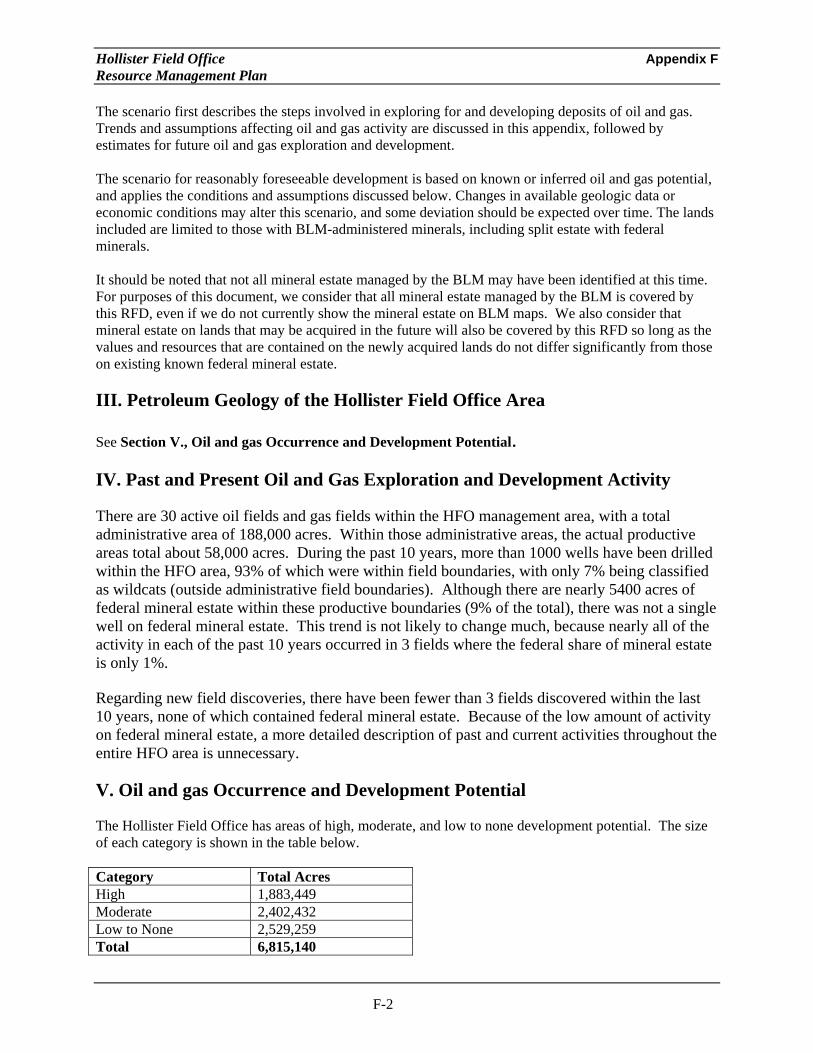
Hollister Field Office Appendix F Resource Management Plan
The scenario first describes the steps involved in exploring for and developing deposits of oil and gas. Trends and assumptions affecting oil and gas activity are discussed in this appendix, followed by estimates for future oil and gas exploration and development.
The scenario for reasonably foreseeable development is based on known or inferred oil and gas potential, and applies the conditions and assumptions discussed below. Changes in available geologic data or economic conditions may alter this scenario, and some deviation should be expected over time. The lands included are limited to those with BLM-administered minerals, including split estate with federal minerals.
It should be noted that not all mineral estate managed by the BLM may have been identified at this time. For purposes of this document, we consider that all mineral estate managed by the BLM is covered by this RFD, even if we do not currently show the mineral estate on BLM maps. We also consider that mineral estate on lands that may be acquired in the future will also be covered by this RFD so long as the values and resources that are contained on the newly acquired lands do not differ significantly from those on existing known federal mineral estate.
III. Petroleum Geology of the Hollister Field Office Area
See Section V., Oil and gas Occurrence and Development Potential.
IV. Past and Present Oil and Gas Exploration and Development Activity
There are 30 active oil fields and gas fields within the HFO management area, with a total administrative area of 188,000 acres. Within those administrative areas, the actual productive areas total about 58,000 acres. During the past 10 years, more than 1000 wells have been drilled within the HFO area, 93% of which were within field boundaries, with only 7% being classified as wildcats (outside administrative field boundaries). Although there are nearly 5400 acres of federal mineral estate within these productive boundaries (9% of the total), there was not a single well on federal mineral estate. This trend is not likely to change much, because nearly all of the activity in each of the past 10 years occurred in 3 fields where the federal share of mineral estate is only 1%.
Regarding new field discoveries, there have been fewer than 3 fields discovered within the last 10 years, none of which contained federal mineral estate. Because of the low amount of activity on federal mineral estate, a more detailed description of past and current activities throughout the entire HFO area is unnecessary.
V. Oil and gas Occurrence and Development Potential
The Hollister Field Office has areas of high, moderate, and low to none development potential. The size of each category is shown in the table below.
Category Total Acres High 1,883,449 Moderate 2,402,432 Low to None 2,529,259 Total 6,815,140
F-2

Hollister Field Office Appendix F Resource Management Plan
High Development Potential
The areas of high oil/gas development potential occur in five areas. The areas, a total of 1,883,000 acres, are depicted in pink on Map 1. They will be described from north to south.
The first area of high oil/gas development potential is in the extreme northern part of the Hollister Field Office area in Contra Costa County. This area is dominated by gas fields that produce from Eocene and Paleocene sedimentary rocks.
The second area of high oil/gas development potential is in the Santa Clara Mountains of southeastern San Mateo and northwestern Santa Cruz Counties. There are no presently active oil or gas fields in the area. However, several drilling programs have identified potential production (“shows”) from Lower Tertiary and Upper Cretaceous formations in this area.
The third area of high oil/gas development potential is in the central part of the Hollister Field Office area in northern San Benito County. The Sargent Oil Field produces from the Miocene Monterey Formation and Pliocene Purisima Formation of the San Juan Valley sedimentary basin.
The fourth area of high oil/gas development potential is in southeastern San Benito County and western Fresno County. This area is part of the San Joaquin Basin, and has several oil fields that produce from Miocene and Pliocene marine sedimentary rocks.
The fifth area of high oil/gas development potential is in southwestern San Benito County and southeastern Monterey County. The most important oil/gas field in this area is the San Ardo field. It, and the other oil fields in the area, produce from the Miocene Monterey formation in the Salinas sedimentary basin.
Moderate Potential
There are several areas of moderate potential within the Hollister Field Office area. These areas, a total of 2,402,000 acres, are shown in yellow on Map 1. They are described as areas with Upper Cretaceous or Lower Tertiary sedimentary rocks containing many wells with oil and gas “shows” or even production, although generally not in economic quantities. Although these areas may contain numerous wells that either had production at one time, or had “shows”, they are classified as having only moderate potential because the rocks in this area are generally more highly fractured, and do not generally have trapping styles or cap rocks that permit sustained development from oil/gas accumulations.
In the southern part of the Hollister Area Office, these rocks are found in three strips along the western central and eastern parts of the Area Office. The eastern strip of Moderate oil/gas potential lies west of high-potential areas of the Sacramento-San Joaquin Basin. This strip lies east of a mass of crystalline and Franciscan metamorphic rocks in the center of the Field Office Area, including the Clear Creek Management Area in the Diablo Mountain Range.
The central strip of moderate oil/gas potential is bounded on the east by a mass of crystalline and Franciscan metamorphic rocks of the Diablo Range and a similar set of igneous and metamorphic rocks in the Coast Ranges.
The western strip of moderate oil/gas potential occurs between the coast and the western foothills of the Coast Ranges.
F-3
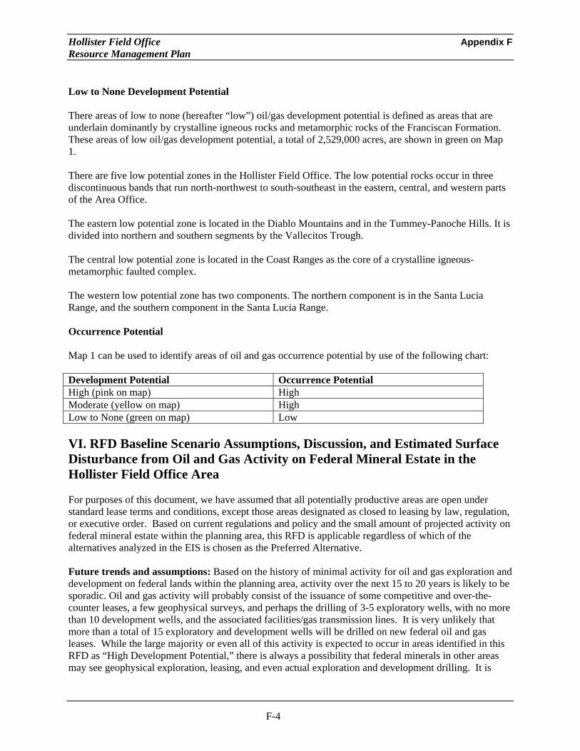
Hollister Field Office Appendix F Resource Management Plan
Low to None Development Potential
There areas of low to none (hereafter “low”) oil/gas development potential is defined as areas that are underlain dominantly by crystalline igneous rocks and metamorphic rocks of the Franciscan Formation. These areas of low oil/gas development potential, a total of 2,529,000 acres, are shown in green on Map 1.
There are five low potential zones in the Hollister Field Office. The low potential rocks occur in three discontinuous bands that run north-northwest to south-southeast in the eastern, central, and western parts of the Area Office.
The eastern low potential zone is located in the Diablo Mountains and in the Tummey-Panoche Hills. It is divided into northern and southern segments by the Vallecitos Trough.
The central low potential zone is located in the Coast Ranges as the core of a crystalline igneous-metamorphic faulted complex.
The western low potential zone has two components. The northern component is in the Santa Lucia Range, and the southern component in the Santa Lucia Range.
Occurrence Potential
Map 1 can be used to identify areas of oil and gas occurrence potential by use of the following chart:
Development Potential Occurrence Potential High (pink on map) High Moderate (yellow on map) High Low to None (green on map) Low
VI. RFD Baseline Scenario Assumptions, Discussion, and Estimated Surface Disturbance from Oil and Gas Activity on Federal Mineral Estate in the Hollister Field Office Area
For purposes of this document, we have assumed that all potentially productive areas are open under standard lease terms and conditions, except those areas designated as closed to leasing by law, regulation, or executive order. Based on current regulations and policy and the small amount of projected activity on federal mineral estate within the planning area, this RFD is applicable regardless of which of the alternatives analyzed in the EIS is chosen as the Preferred Alternative.
Future trends and assumptions: Based on the history of minimal activity for oil and gas exploration and development on federal lands within the planning area, activity over the next 15 to 20 years is likely to be sporadic. Oil and gas activity will probably consist of the issuance of some competitive and over-the-counter leases, a few geophysical surveys, and perhaps the drilling of 3-5 exploratory wells, with no more than 10 development wells, and the associated facilities/gas transmission lines. It is very unlikely that more than a total of 15 exploratory and development wells will be drilled on new federal oil and gas leases. While the large majority or even all of this activity is expected to occur in areas identified in this RFD as “High Development Potential,” there is always a possibility that federal minerals in other areas may see geophysical exploration, leasing, and even actual exploration and development drilling. It is
F-4

Hollister Field Office Appendix F Resource Management Plan
highly unlikely that any wells in such an area would be productive, so any associated surface disturbance would likely be short term.
Geophysical exploration: Geophysical exploration is conducted to determine the subsurface structure of an area and the potential for mineral resources. There are three geophysical survey techniques that are generally used to define subsurface characteristics through measurements of the gravitational field, magnetic field, and seismic reflections.
Gravity and magnetic field surveys—involve small, portable measuring units that are easily transported by light off-highway vehicles, such as 4-wheel drive pickup trucks and jeeps, or aircraft. Both off and on-highway travel may be necessary. Although these two survey methods can take measurements along defined lines, it is more common to have a grid of distinct measurement stations. Surface disturbance resulting from these surveys is negligible, consisting almost exclusively of soil or vegetation compaction that persists no more than a few months.
Seismic reflection surveys—are the most common of the geophysical methods, and they produce the most detailed subsurface information. Seismic surveys are conducted by sending shock waves, generated by a small explosion or by mechanically beating the ground with a thumping or vibrating platform.
In the explosive method, small charges are detonated on the surface or in a shallow drill hole. The surface charge method uses 1 to 5-pound charges attached to wooden laths 3 to 8 feet above the ground. Placing charges lower than 6 feet usually results in destruction of vegetation, whereas placing the charges higher, or on the surface of deep snow, results in little visible surface disturbance. In the drill hole method, holes for the charges are drilled using truck-mounted or portable air drills. In general, this method uses 4 to 12 holes per mile of line, and a 5 to 50-pound explosive charge is placed in each hole, covered, and detonated. The shock wave created is recorded by geophones placed in a line on the surface. In rugged terrain, a portable drill carried by helicopter can sometimes be used. The vehicles used for a drilling program may include heavy truck-mounted drill rigs, track-mounted drill rigs, water trucks, a computer recording truck, and a light pickup.
In the mechanical method, four large trucks are usually used, each equipped with pads about 4-feet square. The pads are lowered to the ground, and the vibrations are electronically triggered from the recording truck. Once information is recorded, the trucks move forward a short distance and the process is repeated. Surface disturbance includes flattening of vegetation and compaction of soils.
In either type of seismic reflection surveys, existing roads and trails are used where possible. However, off-road travel is necessary in some cases. Several trips per day are made along a seismograph line, usually resulting in a well defined two-track trail.
It is expected that no more than three Notices of Intent, involving seismic reflection and gravity/magnetic field surveys across federal surface, would be filed under all Alternatives and the Proposed RMP during the life of this plan. Although it is unlikely, it is possible that one or two of the parcels with federal surface could be involved in a 3-D seismic proposal. If that occurs, the total expected surface disturbance could be up to 9 acres, based on up to 25 miles of seismic lines and a two track road with each track being 18” wide. It is possible that much of the travel could be located on existing roads or other previously disturbed lands, and there could be some hand laying of lines, and that would result in less new disturbance.
Drilling phase: After a parcel is leased, there may or may not be any actual disturbance. In fact, historically, a large majority of leases are relinquished without ever having any actual surface disturbance. In the event that an Application for Permit to Drill (APD) is submitted, a site specific evaluation will be
F-5

Hollister Field Office Appendix F Resource Management Plan
made by the BLM to ensure compliance with NEPA requirements. Based on the results of that evaluation, additional Conditions of Approval may be added, and the operator may only begin construction after complying with lease stipulations and Conditions of Approval of the drilling permit. When a site requires construction of an access road, the shortest feasible route is usually selected to reduce the haul distance and construction costs. Environmental factors or a landowner’s wishes may dictate a longer route in some cases. Drilling in the planning area is expected to be done using existing roads and construction of only short (approximately 0.5 mile) roads to access drill site locations.
Even though there are 30 active oil fields and gas fields that are partly or totally within the Hollister FO area, only 9% land within the productive boundaries of those fields contains federal minerals (5400 federal acres out of a total of more than 58,000 acres). In the past ten years, 1030 wells have been drilled in the entire FO area, but no wells have been drilled on federal minerals within the entire FO area. Consequently, based on the history of oil and gas exploration in the planning area, it is projected that no more than three to five exploratory wildcat wells (wells outside of the administrative boundary of existing oil and gas fields) would be drilled on BLM-administered land in the planning area during the life of this plan. Although the success rate for wildcat wells has improved markedly during the past decade, largely due to improved seismic data, it is still unlikely that any new fields would be discovered by drilling on federal minerals because there is so little activity in areas with significant amount of federal mineral estate.
Most drilling is expected to occur in areas of land designated as high development potential (shown in pink on Map 1). Although there is a low probability that a field will be discovered on federal land during the life of this plan, if a field containing federal land were to be discovered in the northern portion of HFO area, it is likely that the discovery would be gas because all of the occurrences in that area are gas. Conversely, if a field containing federal land were to be discovered in the southern portion of HFO area, it is likely that the discovery would be oil because all of the occurrences in that area are oil.
During the first phase of drilling, the operator would move construction equipment over existing maintained roads to the point where the access road begins. Less than 0.5 mile of moderate duty access road per well with a gravel surface 20 feet wide is expected for construction. With ditches, cuts, and fill, the total width of surface disturbance would average 40 feet. The second part of the drilling phase is the construction of a drill pad up to 1 acre in size. The likely duration of well drilling, testing, and abandonment is 3 or 4 months per site. The total disturbance for each exploratory well and any new road is estimated to be 3.4 acres. The total surface disturbance caused by exploratory drilling of 3-5 wells over the life of this plan is expected to be no more than 10-17 acres.
Field development and production: Exploratory drilling is not expected to lead to the development of a producing field in the planning area. Nonetheless, the following scenario describes the operations and effects associated with field development.
The minimum size considered economically feasible would depend mainly on its proximity to existing infrastructure. There are many fields within the boundaries of the HFO area, mostly in the extreme southern and extreme northern portions of the area, and it is likely that any pipelines from a new field would be relatively short. The wells within the actual productive boundaries (smaller than the administrative boundaries) of gas fields are spaced on average at 80-160 acres. For oil fields in the HFO area, spacing is much closer. In the larger oilfields, usual development spacing is typically at 5-7 acres per well. However, spacing can be as close as well well per acre in areas with heavy oil. Although it is unlikely that a new field will be discovered on federal minerals, for planning purposes we will assume a fairly small to mid size oil field may be discovered somewhere within the planning area. The average field size in the FO area is over 1900 acres, but that is significantly skewed by the presence of a few very large fields. The bottom 80% of the active fields in the FO area average 650 acres, about one square mile.
F-6

Hollister Field Office Appendix F Resource Management Plan
If a single oilfield of that size was discovered, on average it would contain 9.1% federal mineral estate, about 60 acres. At 5-7 acres per well, it would take approximately 10 wells to fully develop the parcel. Each development well would require an estimated 0.25 mile of road, which would have a surface of crushed aggregate or gravel approximately 20 feet wide (total disturbed width of 40 feet). Well pads would be no more than 1 acre in size. Oil/gas produced would be carried by pipelines that could be linked to existing and proposed transmission lines in the planning area. Average infield pipeline length is estimated to be 0.25 mile per well, which could probably be largely contained within the road right of way and little new surface disturbance would be required. The total distance from a new field to an existing transmission pipeline is likely to be less than 10 miles. The width of the surface disturbance for pipelines would average 20 feet.
The total surface disturbance for up to 10 development wells would be 10 acres for well pads, 12 acres for roads, and 24 acres for a single transmission line 10 miles long. No more than 1 acre would be required for the small facility (meter, separator) on each parcel. For planning purposes, we will assume that the wells may be on two separate parcels, so there would be a total of 2 acres for facilities. The total surface disturbance caused by seismic operations, exploration drilling, and development would be 74 acres.
Description Number Unit Surface Disturbance
(acres)
Total Surface Disturbance
(acres) Exploratory Wells
Well Pads Roads (40’ wide)
5 wells 5 x 0.5 miles
1 acre/well 4.8 acre/mile
5 12
Development Well Pads
Roads (40’ wide) Facilities
10 10 x 0.25 mi 2
1 acre/well 4.8 acre/mile 1 acre/facility
10 12 2
Seismic (2 track x 18”) 25 miles 0.36 acre/mi 9 Pipeline (20 ‘ wide) 10 miles 2.4 acres/mi 24
Total: 74
Plugging and abandonment: Wells that are drilled and determined to be dry holes are plugged according to a plan designed for the condition of each well. Plugging involves placing cement plugs at strategic locations in the hole. Drilling mud is used as a spacer between the plugs to prevent communication between fluid-bearing zones. The drill casing is cut off at least 5 feet below ground level and capped by welding a steel plate on the casing stub. After plugging, all equipment and debris would be removed and the site restored as near as reasonably possible to its original condition. It is projected that much of the surface disturbance from exploratory activities and all of the seismic activities would be of short duration (between a few months and a couple of years). The impacts from the successful development wells would last longer, but it would still be completely reclaimed eventually
Military Bases – Fort Hunter Liggett military base is within the planning area. Leasing these lands requires consent from the local Base Commander. It has been shown in numerous cases across the country and within California that oil and gas exploration and development can often be conducted in a manner that is fully compatible with ongoing military operations. It is quite possible that negotiations between BLM and military personnel may result in agreement to lease lands within the boundaries of bases or other military lands. In the event that happens, appropriate leasing stipulations that would fully protect the military’s mission will be added prior to any land being leased.
F-7

Hollister Field Office Appendix F Resource Management Plan
Authors: BLM Bakersfield Field Office Lead - Jeff Prude – Petroleum Engineer – Field Office Oil and Gas Program Lead
Gregg Wilkerson - Geologist W/ Assistance from Larry Vredenburgh – GIS Specialist
F-8


