SOUTHEASTERN IRAN - Northwestern University · REPORTONFIELD WORKSHOP SUSTAN and BELUCHISTAN...
23
REPORT ON FIELD WORKSHOP SUSTAN and BELUCHISTAN PROVINCE SOUTHEASTERN IRAN 09 - 19 October 2010 The "Mars Mountains" of Beluchistan Coastal Highway — Beris to Lipar Thursday, 14 October 2010 Emile A. OKAL Northwestern University
-
Upload
truongngoc -
Category
Documents
-
view
215 -
download
2
Transcript of SOUTHEASTERN IRAN - Northwestern University · REPORTONFIELD WORKSHOP SUSTAN and BELUCHISTAN...

REPORT ON FIELD W ORKSHOP
SUSTAN and BELUCHISTAN PROVINCE
SOUTHEASTERN IRAN
09 − 19 October 2010
The "Mars Mountains" of BeluchistanCoastal Highway — Beris to Lipar
Thursday, 14 October 2010
Emile A. OKAL
Northwestern University
Report on Field Workshop, Sistan and Beluchistan Province, Southeastern I ran
09 − 19 October 2010
This field workshop was organized under the auspices of UNESCAP in the aftermath of theprevious workshop, held in Tehran from 01 to 05 May 2010. The goals of the field workshopwere (i) to obtain testimonies from elderly witnesses of the 1945 Makran tsunami and organizethem into a homogeneous scientific database; and (ii) to explore the possibility of obtaining,through trenching, paleotsunami data regarding both the 1945 event and any possible predeces-sors. Inaddition to these fundamental goals, information was also gathered regarding the effectsof the 2004 Sumatra tsunami, as well as of extreme meteorological events, such as CycloneGonuin 2007.
The team assembled in Tehran on 09 October 2010. Trainers included Professor Emile A.Okal (France; Northwestern University), Professor Hermann M. Fritz (Switzerland; Georgia Insti-tute of Technology), Professor C.P. Rajendran (India; Center for Earth Science Studies), Dr. EkoYulianto (Indonesian Institute of Science), and Mr. Majid Shah-Hosseini (Iran; CEREGE).
For logistical reasons, the team split into two groups. One group, led by Professor Okal andcomprising Mr. Mohammad Ali Hamzeh and Professor Javad Ghasemzadeh operated from a baseat the Research Station of the Iranian National Institute of Oceanography in Chahbahar, andfocused exclusively on surveying the 1945 tsunami along the coast of the Province of Sistan andBeluchistan. Thesecond group, led by Professor Fritz, operated in the Province of Hormozgan,and focused on the paleotsunami and meteorological aspects. The present report is limited to theactivities of the Chahbahar group.
Reconstructing the 1945 tsunami in Sistan-and-Beluchistan Province
Professor Okal and Mr. Hamzeh flew from Tehran to Chahbahar in the morning of Sunday, 10October. Field work started in the afternoon, following a visit to the Research Station.
General Remarks
While we tried very hard to recover information about our witnesses, the question of their ageoften remains unresolved. Several witnesses claiming to be in their early sixties, had unquestion-ably vivid memories of the tsunami which should then have predated their birth. By contrast,younger family members had a general tendency to extrapolate the age of their elderly relatives,one adolescent even describing his grandfather as being 100 years old while offering him asporty ride on his moped; in our opinion, this witness was probably in his early seventies, as sug-gested by his status as a bachelor at the time of the 1945 tsunami. It is with such reservations thatwe offer estimates of the age of our witnesses.
Similarly, the times given by witnesses for the observation of natural phenomena are generallyapproximate. Whenever possible, we attempted to ascertain them using reference activities (e.,g.,morning prayer).

-2-
Tiss
On Sunday afternoon, 10 October, we visited the jetty in the port area of Tiss, a suburb ofChahbahar. We met a fisherman in his sixties, who related the story of his late father whohad observed the water running up in the drainage channel of the village of Tiss, across thebay, up to the vicinity of the village mosque (Figure 1). This transect was surveyed onMonday, 11 October, with a run-up of 1.65 m and an inundation of 1289 m(Site Number01).
An additional testimony, not directly relevant to the Iranian survey, was obtained from a62−yr. old man who had heard from a sailor who had been in Jiwani (on the Pakistani sideof the border) during the 1945 tsunami, and witnessed the emergence of a new island, to areported height of 15 m above sea level; this island is said to be gradually coming downnow.
Regarding the 2004 Indonesian tsunami, we obtained the testimony of Mr. AbdalghaniSiahuee, who described an anomalous sound around 11 a.m. (07:30 GMT), followed anhour later by flooding of the jetty up to a[n uncorrected] height of 3.35 m(Site Number21), resulting in several boats breaking their moorings.
Konarak
On Tuesday, 12 October 2010, we traveled to the western shores of the Bay of Chahbahar,home of the major fishing community of Konarak, and later to the port of Pozm.
A first witness gav eus a precise report of the inundation of the 1945 tsunami reaching tothe middle of the block past the mosque, and related that the water penetrated into a houseadjacent to the mosque, disrupting a week-long wedding ceremony. The witness remembersbeing about 12−13 years old at the time, but claims to be only 67 in 2010.
A second witness confirmed inundation of the mosque, but was clearly confused in terms ofdates, claiming to have been in his twenties at the time, but only 60 years old in 2010.
A third, and in our opinion more reliable, witness confirmed that the water penetrated themosque, disrupted morning prayers (estimated around 4 a.m. local time), broke windowsand left a few people injured with broken limbs, although no deaths were known to him inKonarak. Onemonth later, he traveled to Pasni and Ormora (in Pakistan), where the cityhad been totally destroyed. Thiswitness claimed to have been 20 to 25 years old at thetime and to be in his eighties now.
The combination of these testimonies is translated into a surveyed run-up of 3.05 m and aninundation of 52 m(Site Number 02;Figure 2).
Regarding the 2004 tsunami, witnesses indicating flooding to the front of the coastal road,for a run-up of 2.20 m and an inundation of 26 m(Site Number 22).
Pozm
We could not find witnesses of the 1945 tsunami in Pozm, where the 2004 tsunami wasremembered by a number of witnesses on the port jetty. The latter, measured at 1.80 mabove sea level, was not flooded to its top. In the village (Figure 3), a witness indicated thathis boat, which he was cleaning, was beached during the ebbing phase, and later floatedback. At the estuary of the river, the sea ran up to 1.10 m on the local beach(Site Number23), and 1.95 m on a bluff near the town schoolyard(Site Number 24).

-3-
Chahbahar
Thanks to proactive groundwork by Mr. Hamzeh prior to the survey, we were able to inter-view sev eral reliable witnesses in the city of Chahbahar itself on Monday, 11 October (Fig-ure 4). Among them, we had a long interview in his house with Mr. Rahmat Khodadian,who claims to be 75 years old, clearly a very educated person, who indicated an arrival ofthe wav es around 03:30 a.m., and an inundation reaching to the present location of theBank Melli, near the downtown beach. This location(Site Number 03)was surveyed on13 October for a run-up of 3.65 m and an inundation of 367 m. The witness mentioned ashis only known ancestral memoryof major inundation following an earthquake a case"about 200 years ago in India", which is most probably the 1819 earthquake in Gujarat,during which the Rann of Kuchchh was flooded, but without generation ofa genuinetsunami by this continental earthquake. This observation reinforces the absence of ancestralmemory from true tsunamigenic events other than the 1945 one along the Makran coast.Mr. Khodadian also mentioned that the telegraph cable (presumably from Europe) was notsevered in Chahbahar, by contrast with the situation farther East, as reported in the Indianpress, suggesting that the Indian cable was cut by a local submarine landslide.
We also interviewed a female witness, aged about 13 at the time of the tsunami, whorecalled the destruction, by the wav es, of straw houses in the low lands neighboring thebeach, resulting in several fatalities, a description which would generally agree with therun-up surveyed at Site Number 03.
During the 2004 Indonesian tsunami, the main cargo harbor of Chahbahar saw some500-ton boats break their moorings and wander inside the harbor, reportedly around 5 p.m.local time, i.e., 13:30 GMT or 5 to 6 hours after the arrival of the first wav es. Theseepisodes are reminiscent of similar effects in Toamasina, Madagascar; Le Port, Re´union;Dar-es-Salaam, Tanzania, and Salallah, Oman. They are attributable to the arrival of higherfrequency components of the tsunami, dispersed outside the shallow-water approximation,and capable of setting ports in resonance.
Ramin
Ramin is a village located 12 km East of Chahbahar on the coastal highway. It is built at analtitude of about 15−20 m, behind dunes topping at an estimated 40 m. It features animproved harbor, next to a small beach which drains a river bed (dry at the time of ourvisit). To the East, the coast transforms into a series of cliffs, on which a large number ofimbricated boulders (Figure 5) have been deposited by catastrophic ocean wav es, whoseorigin (tsunami or cyclone) remains unclear. We identified a witness who reported to us thatthe boulders were reached by the 1945 tsunami, but that they had been present before. Weinterpret this information as a splash on the cliff at a height of 7.15 m(Site Number 04).
Lipar
Lipar is a small community located at the mouth of a major river (also named Lipar) whichdrains a vast hinterland plain, capable of retaining some water in the form of intermittentlakes and marshes after heavy precipitations, following the building of a levee damming theLipar. The coastal road crosses the valley on an artificial causeway. Lipar is presentlyinhabited by about a dozen people, but in 1945, a community existed at the foot of thecliffs, some 3 km inland.
We identified as a witness Mr. Ghalamhossein Dadshahpour, who used to live in Lipar butnow living in Ramin, who remembered being in his early teens at the time of tsunami (andclaims to be 73 years old in 2010). We drove him in our field vehicle to the beach in Lipar,
-4-
where he guided our survey (Figure 6). He described three big wav es coming in "the earlymorning", and which carried boulders from the sea to the berm at the estuary (latelycov-ered with sediments). Based on his recollections, we measured(Site Number 05)a run-upof 2.80 m for an inundation of 540 m, to the present huts (which did not exist in 1945); thetsunami penetrated some 3−4 km inside the river bed (now beyond the damming levee).
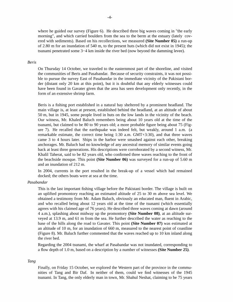
Beris
On Thursday 14 October, we traveled to the easternmost part of the shoreline, and visitedthe communities of Beris and Pasabandar. Because of security constraints, it was not possi-ble to pursue the survey East of Pasabandar in the immediate vicinity of the Pakistani bor-der (distant only 20 km at this point), but it is doubtful that any elderly witnesses couldhave been found in Gavater given that the area has seen development only recently, in theform of an extensive shrimp farm.
Beris is a fishing port established in a natural bay sheltered by a prominent headland. Themain village is, at least at present, established behind the headland, at an altitude of about50 m,but in 1945, some people lived in huts on the low lands in the vicinity of the beach.Our witness, Mr. Khaled Baluch remembers being about 10 years old at the time of thetsunami, but claimed to be 80 to 90 years old; a more probable figure being about 75 (Fig-ure 7). He recalled that the earthquake was indeed felt, but weakly, around 1 a.m. (aremarkable estimate, the correct time being 1:30 a.m. GMT+3:30), and that three wav escame 3 to 4 hours later. Ships in the harbor were smashed against each other, breakinganchorages. Mr. Baluch had no knowledge of any ancestral memory of similar events goingback at least three generations. His descriptions were corroborated by a second witness, Mr.Khalil Taherat, said to be 82 years old, who confirmed three wav es reaching to the front ofthe beachside mosque. This point(Site Number 06)was surveyed for a run-up of 5.60 mand an inundation of 212 m.
In 2004, currents in the port resulted in the break-up of a vessel which had remaineddocked; the others boats were at sea at the time.
Pasabandar
This is the last important fishing village before the Pakistani border. The village is built onan uplifted promontory reaching an estimated altitude of 25 to 30 m above sea level. Weobtained a testimony from Mr. Adam Baluch, obviously an educated man, fluent in Arabic,and who recalled being about 12 years old at the time of the tsunami (which essentiallyagrees with his claimed age of 76 years). He described three wav es coming at dawn (around4 a.m.), splashing about midway up the promontory(Site Number 08), at an altitude sur-veyed at 13.9 m, and 61 m from the sea. He further described the water as reaching to thebase of the hills along the road to Gavater. This point(Site Number 07)was estimated atan altitude of 10 m, for an inundation of 660 m, measured to the nearest point of coastline(Figure 8). Mr. Baluch further commented that the wav es reached up to 10 km inland alongthe river bed.
Regarding the 2004 tsunami, the wharf at Pasabandar was not inundated, corresponding toa flow depth of 1.0 m, based on a description by a number of witnesses(Site Number 25).
Tang
Finally, on Friday 15 October, we explored the Western part of the province in the commu-nities of Tang and Bir Daf. In neither of them, could we find witnesses of the 1945tsunami. In Tang, the only elderly man in town, Mr. Shahul Neshat, claiming to be 75 years

-5-
old, could not remember any such event. By contrast, in 2004 several witnesses described 3waves arriving in late morning which deposited a boat at the maximum storm surge watermark, and sank another one during an ebbing phase.Based on these witnesses’ testimony,we surveyed a run-up of 1.1 m for an inundation of 229 m at this location(Site Number26), protected by a barrier island (Figure 9).
Bir Daf
To the West, the community of Bir Daf is built 1.5 km inland. The beach slopes quickly to aberm of dunes (Figure 10). A witness described to us the arrival of 2 wav es, around 8 a.m.(which is probably erroneous), and a run-up half-way up the berm, to a height of 3.8 m, foran inundation of 35 m(Site Number 27).
Additional data points from the Western Group
We include in this report data points surveyed by the Western team led by Professor Fritz.The team obtained one witness report of the 1945 tsunami at Souraf(Site Number 09;Fig-ure 11) and 4 reports for the 2004 events(Site Numbers 28−31).
Data Processing
All the data points listed in this report were surveyed using a hand-held GPS device. The exacttime at which the survey took place was recorded to allow a tidal correction. The latter made useof the tidal computation algorithm on the web site of the French Service Hydrographique etOceanographique de la Marine, by averaging the tidal computations available for Muscat, Omanand Karachi, Pakistan.
The entire dataset for 1945 is appended as Table 1, that for 2004 as Table 2. The datasets are pre-sented graphically on Maps 1 and 2.
Other Activities
• Seminar at Chahbahar Maritime University
On Saturday evening, 16 October 2010, and at the invitation of Professor Ghasemzadeh,Professor Okal gav ea lecture introducing the general concepts of tsunamis, their effectsand the role of scientists in their mitigation, to a group of several students in a large audito-rium of the University. This lecture, translated in real time by Dr. Ghasemzadeh, was fol-lowed by a questions-and-answers session, lasting until 10:30 p.m.
• Keep Clean the Beaches
On Sunday, 17 October 2010, Professor Okal joined his Iranian colleagues on the beachesto the East of Chahbahar, where school children were involved in a clean-up effort of accu-mulated garbage (Figure 12). On this occasion, he gav ea short lecture about the resilienceof plastic components as a threat to the food chain, both to the children and to a local tele-vision station.
All the participants in the field workshop flew back to Tehran on Monday, 18 October. Adebriefing session (Figure 13) was held at the Iranian National Institute of Oceanography onTuesday 19 October, where the initial results of the field work were presented, and certificatesaw arded to all participants.
-6-
Conclusions
• We were able to build a set of 9 data points for the 1945 Makran tsunami. While most run-up values are in the 3−m range, they ramp up to significantly higher values near the Pak-istani border.
It is clear that this study would benefit from being extended to the Pakistani side of the bor-der, where the testimony of witnesses who were on travel in Pakistan in 1945 confirms amuch higher level of inundation and destruction.
• The witnesses generally described a series of three wav es, arriving between 3:30 and 4:30a.m. In this respect, the phenomenon is clearly delayed with respect to direct propagationfrom the epicentral area. This delay would be compatible with the generation of thetsunami by an ancillary phenomenon, such as an underwater landslide. It could also beattributable to propagation as an edge wav eon the continental shelf.
In a most remarkable testimony, one witness recalled feeling the earthquake "around 1 a.m.(21:30 GMT)" in Beris. The earthquake took place at 21:56 GMT and its shear wav eswould have been felt in Beris within one minute of occurrence.
• The witnesses we interviewed did not possess any ancestral memory of comparable eventsprior to the occurrence of the 1945 tsunami. By contrast, one of our witnesses expressed amemory of the distant earthquake of 1819 in the Rann of Kuchchh. This would suggest thatthe Makran earthquake of 1851, reported by Ambraseys and Melville [1982] to haveoccurred to the West of the 1945 shock, was of comparably lower magnitude.
• The 2004 Sumatra tsunami had significant run-up, in the 3−4 m range, along the whole sur-veyed segment of coastline. It involved delayed response effects in the port of Chahbahar,due to the dispersed arrival of the higher frequency components of the tsunami.
Acknowledgments
This workshop was made possible by a grant from UNESCAP.
In addition, we gratefully acknowledge the support of the Iranian National Institute forOceanography, particularly its Director, Dr. Vahid Chegini, as well as Mr. Majid Naderi,Mr. Nima Kiani and Ms. Fahimeh Foroughi in Tehran. InChahbahar, we are grateful to ourhost at the Research Station of INIO, Mr. Mohammad Ali Hamzeh and his staff, in particu-lar our driver, who took a personal interest in the project, and provided translation from theBeluchi language during our interviews. We thank Professor Javad Ghasemzadeh for hiswelcome at the Chahbahar Maritime University, in particular for arranging the seminar.
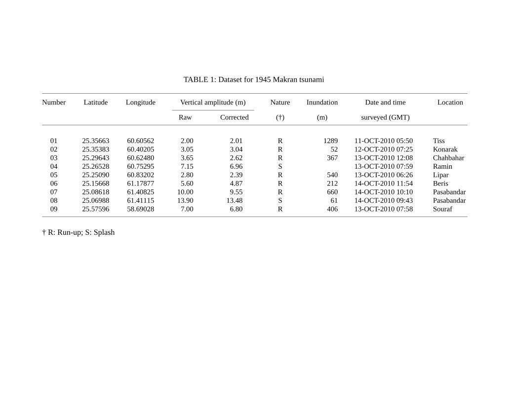
TABLE 1: Dataset for 1945 Makran tsunami
Number Latitude Longitude Vertical amplitude (m) Nature Inundation Date and time Location
Raw Corrected (†) (m) surveyed (GMT)
01 25.35663 60.60562 2.00 2.01 R 1289 11-OCT-2010 05:50 Tiss02 25.35383 60.40205 3.05 3.04 R 52 12-OCT-2010 07:25 Konarak03 25.29643 60.62480 3.65 2.62 R 367 13-OCT-2010 12:08 Chahbahar04 25.26528 60.75295 7.15 6.96 S 13-OCT-2010 07:59 Ramin05 25.25090 60.83202 2.80 2.39 R 540 13-OCT-2010 06:26 Lipar06 25.15668 61.17877 5.60 4.87 R 212 14-OCT-2010 11:54 Beris07 25.08618 61.40825 10.00 9.55 R 660 14-OCT-2010 10:10 Pasabandar08 25.06988 61.41115 13.90 13.48 S 61 14-OCT-2010 09:43 Pasabandar09 25.57596 58.69028 7.00 6.80 R 406 13-OCT-2010 07:58 Souraf
† R: Run-up; S: Splash

TABLE 2: Dataset for 2004 Sumatra tsunami
Number Latitude Longitude Vertical amplitude (m) Nature Inundation Date and time Location
Raw Corrected (†) (m) surveyed (GMT)
21 25.35523 60.60022 3.35 2.66 F 10-OCT-2010 11:05 GMT Tiss Harbor22 25.35383 60.40205 2.20 3.18 R 26 12-OCT-2010 06:52 GMT Konarak23 25.36018 60.31382 1.10 2.09 R 12-OCT-2010 08:23 GMT Pozm24 25.35823 60.31350 1.95 2.92 R 12-OCT-2010 08:30 GMT Pozm25 25.06838 61.41687 1.00 1.61 F 14-OCT-2010 09:55 GMT Pasabandar26 25.35720 59.89457 1.10 1.50 R 15-OCT-2010 08:47 GMT Tang27 25.40330 59.81385 3.80 4.26 R 35 15-OCT-2010 10:02 GMT Bir Daf28 25.56027 58.81188 2.30 3.27 R 39 12-OCT-2010 06:48 GMT Gugsar29 25.56922 58.70377 1.80 2.24 R 62 13-OCT-2010 05:31 GMT Geshmi30 25.56746 58.20059 1.60 1.85 R 21 15-OCT-2010 06:00 GMT Surgalm31 25.74627 57.73561 3.10 3.24 R 55 16-OCT-2010 07:26 GMT Lafi
† R: Run-up; F: Flow depth

58˚
30'
59˚
00'
59˚
30'
60˚
00'
60˚
30'
61˚
00'
61˚
30'
62˚
00'
24˚
30'2
5˚
00'2
5˚
30'2
6˚
00'
5101520meters
N
Konara
k
Chahbahar
Ram
in
Lip
ar B
eris
Pasabandar
Soura
f
1945
MA
KR
AN
TS
UN
AM
I
Run
-up
Spl
ash
Map
1.:
Sum
mar
y of
sur
vey re
sults
for
the
1945
tsun
ami.

57˚
30'
58˚
00'
58˚
30'
59˚
00'
59˚
30'
60˚
00'
60˚
30'
61˚
00'
61˚
30'
62˚
00'
24˚
30'2
5˚
00'2
5˚
30'2
6˚
00'
2468meters
N
Pozm
Konara
k Tis
s
Pasabandar
Tang
Bir D
af
Geshm
i
Gugsar
Surg
alm
Lafi
2004
SU
MA
TR
A T
SU
NA
MI
Run
-up
Flo
w D
epth
Map
2.:
Sum
mar
y of
sur
vey re
sults
for
the
2004
tsun
ami.

Figure 1.: Interview of a 62−yr old witness on the jetty of the port of Tiss, in the suburbs ofChahbahar(Top).
Based on the story of his late father, we reconstructed the inundation of the 1945 tsunami,which reached the mosque in the background of thebottomframe(Site Number 01)
Sunday, 10 October 2010

Figure 2.: Interviews in the port city of Konarak. First witness(Top)and third witness(Bottom).
Tuesday, 12 October 2010

Figure 3.: Surveying the 2004 tsunami in Pozm.Sites Number 23(Top)and24 (Bottom).
Tuesday, 12 October 2010

Figure 4.: Interviews and surveying in Chahbahar. Top Left, from left to right: Prof. Ghasemzadeh, Prof. Okal, Mr. Hamzeh, INIO Driver, Witness(Monday, 11 October 2010);Bottom Left:Site Number 03(Wednesday, 13 October 2010).Arrow shows present Bank Melli building reached by wav ein 1945.Interview photos courtesy J. Ghasemzadeh.
↓

Figure 5.: Inter view (Top; Tuesday, 12 October 2010)and surveying (Bottom; Wednesday, 13October 2010)at Ramin. Note the boulders deposited on the cliff at an altitude of about 7 mabove sea level. Photographs courtesy J. Ghasemzadeh.
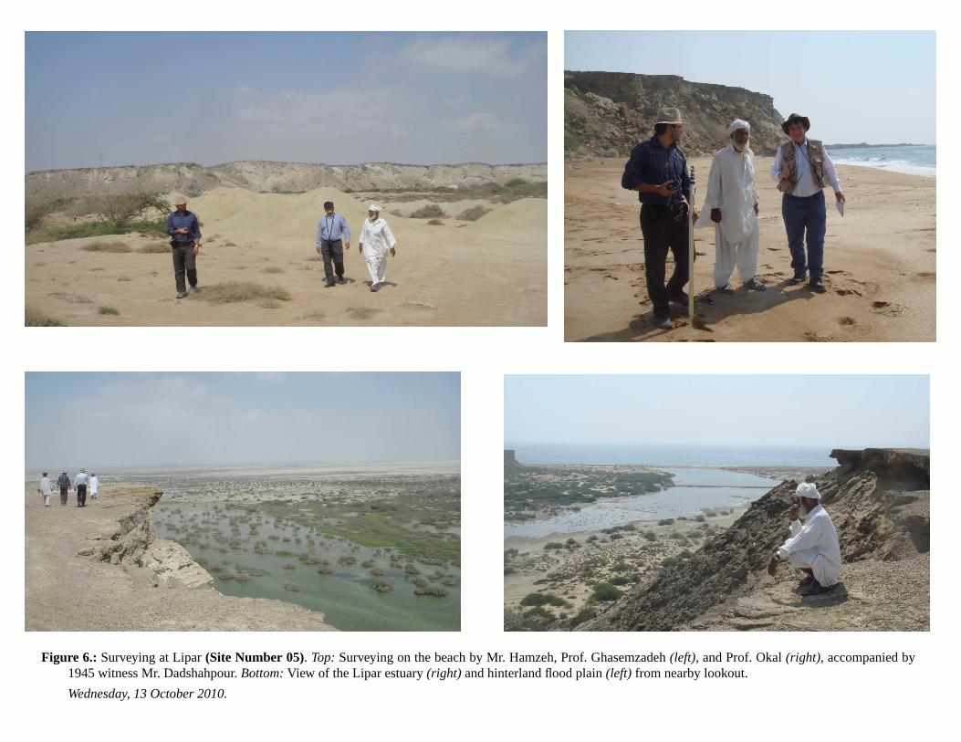
Figure 6.: Surveying at Lipar(Site Number 05). Top: Surveying on the beach by Mr. Hamzeh, Prof. Ghasemzadeh(left), and Prof. Okal(right), accompanied by1945 witness Mr. Dadshahpour.Bottom:View of the Lipar estuary(right) and hinterland flood plain(left) from nearby lookout.
Wednesday, 13 October 2010.

Figure 7.: Top: The port of Beris, sheltered by a largepromontory. Center:Interview of 1945 witness Mr.Beluch. Left to Right: Prof. Ghasemzadeh, Prof.Okal (taking notes), INIO driver (back to camera).Bottom:Site Number 06near Beris mosque.
Thursday, 14 October 2010

Figure 8.: Top: Interview of 1945 witness Mr.Baluch (shown with grandchildren) at Pasa-bandar;Left to Right:Mr. Hamzeh, INIOdriver, Prof. Okal. Center: Survey SiteNumber 08 along cliff; note road to port,built since 1945.Bottom: Estuarine plainNorth of Pasabandar. The 1945 tsunamiflooded it, reaching to the base of thesehills, at Site Number 07. Top and Centercourtesy J. Ghasemzadeh.
Thursday, 14 October 2010

Figure 9.: Surveying of the 2004 Sumatra tsunami at Tang(Site Number 26). In the back, notebarrier island offering protection to the site.Photographs courtesy J. Ghasemzadeh.
Friday, 15 October 2010.
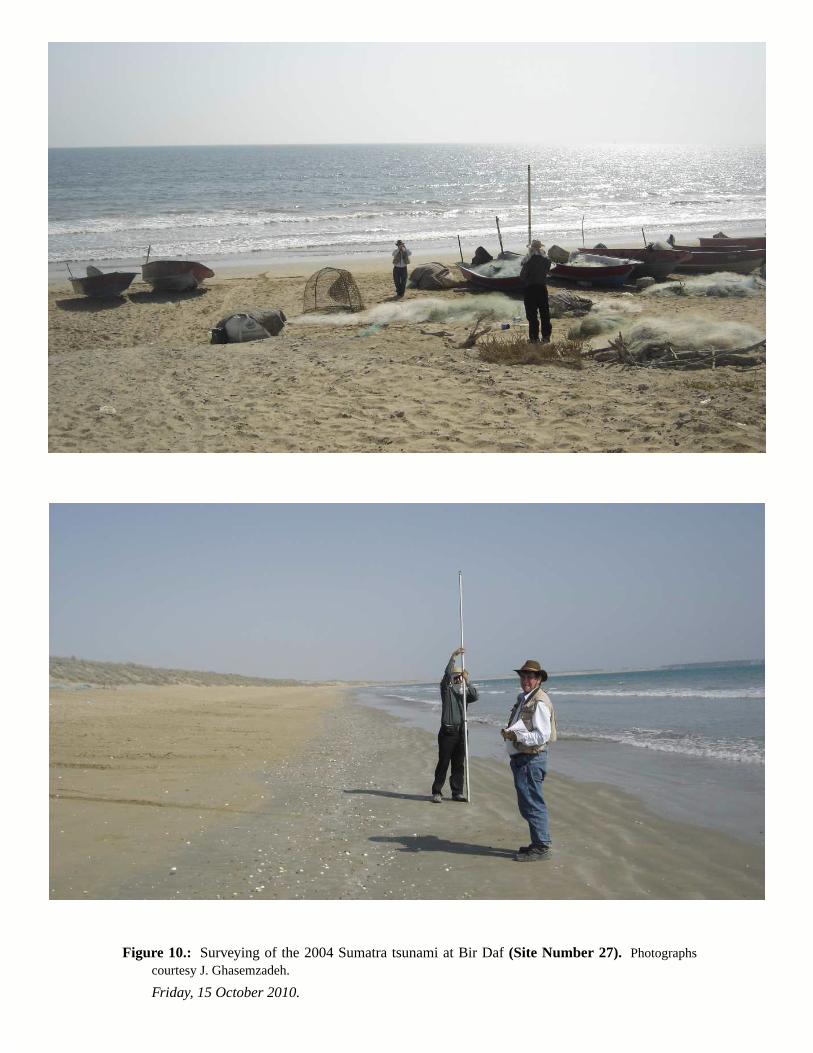
Figure 10.: Surveying of the 2004 Sumatra tsunami at Bir Daf(Site Number 27). Photographscourtesy J. Ghasemzadeh.
Friday, 15 October 2010.

Figure 11.: Top: Interview of 1945 witness(right) at Souraf(Site Number 09). Bottom:Surveyat Souraf.Photographs courtesy H.M. Fritz.
Wednesday 13 October 2010.

Figure 12.: Professor Okal (with dark hat) joins schoolchildren participating in the clean-up ofthe beach at Chahbahar.
Sunday, 17 October 2010.
Figure 13.: Group photograph at the conclusion of the workshop, at the Headquarters of INIO in Tehran.
Tuesday, 19 October 2010.