Southcentral Alaska small hydroelectric projects ... · PDF fileSouthcentral Alaska Small...
39
" • Q PLANNING AID REPORT Southcentral Alaska Small Hydroelectric Projects Reconnaissance Phase Prepared for U.S. Army, Corps of Engineers Alaska District u.s. FISH & WILDLIFE SERVICE Prepared by u.s. Department of the Interior Fish and Wildlife Service Western Alaska Ecological Services February, 1983
Transcript of Southcentral Alaska small hydroelectric projects ... · PDF fileSouthcentral Alaska Small...

"
• Q
PLANNING AID REPORT
Southcentral Alaska Small Hydroelectric Projects
Reconnaissance Phase
Prepared for
U.S. Army, Corps of Engineers Alaska District
u.s. FISH & WILDLIFE
SERVICE
Prepared by
u.s. Department of the Interior Fish and Wildlife Service
Western Alaska Ecological Services
February, 1983
United States Department of the Interior
IN REPLY REFER TO: WAES
FISH AND WILDLIFE SERVICE
Western Alaska Ecological Services 605 W. 4th, Room G-81
Anchorage, Alaska 99501
Colonel Neil E. Saling District Engineer - Alaska Corps of Engineers 18 FEB 1~83 PO\.lCh 898 Anchorage, Alaska 99506
Dear Colonel Saling:
The enclosed correspondence transmits our Planning Aid ~eport, as it pertains to the environmental assessment of the proposed Southcentral Alaska small hydroelectric projects.
Fish and wildlife information presented in our report was coordinated with the Alaska Department of Fish and Game. The report was prepared in accordance with the provisions of the Fish and Wildlife Coordination Act (48 Stat. 401, as amended; 16 U.S.C. 661 et seq.), but does not constitute the report of the Secretary of the Interior within the meaning of Section 2(b) of the Act, nor does it constitute consultation required under Section 7 of the Endangered Species Act (87 Stat. 884, as amended).
Please review our report and provide us written ·comments within 30 days.
Enclosure
cc: Nadeau ROES ADF&G, Anchorage ID1FS, Anchorage
Field Supervisor

--L.~----------------------~----~------------------------------------~---------
! i
I l
I
f I ' I I I ,
librar)f' U S F. h & wn dlife Service • • IS .
1011 E. Tuc!nr Road Anchorage, Alaska 99503
SOUTHCENTRAL ALASKA S~mLL.HYDROELECTRIC PROJECTS
Reconnaissance Phase ~
PLANNING AID REPORT
Submitted to Alaska District U.S. Army Corps of Engineers
Anchorage, Alaska
I
~
Prepared by: Wayne M. Crayton and Marian Zimmerman Approved by: Robert G. Bowker, Field Supervisor
Western Alaska Ecological Services Field Office U.S. Fish and Wildlife Service
Anchorage, Alaska
February, 1983

__L.i~ L----------------------------------------------------------------------------------------
TABLE OF CONTENTS
Introduction ••• oo•oooeeeoeeoeoeooeeeo••••••••••••o••••••••••• 1
Bear Creek- Hope, Alaska ••••••••• O'l!lo••••••••••e•••••••••
Stu dj1 Area . ........ ~~~ . o e •••••• .,••••••••flo eo•••••••••• Project Description~ •••••...•.••••••. Fish and Wildlife Resources •••••.•••. Discussion .•••••••.•.••..••••.... i. Recommendations ••....•.••••••
Kings River- Chickaloon, Alaska ••..••• ............. ~ ..... . Stucy Area . ........ ~~ ................. . Project Description .•.••••••••.•••••.••.•.••.•••..•.•••.•.•• Fish and Wi 1 dl i fe Resources ••......•••••••••••.••••••••..•.. Discussion .••••..•••.•••••••...••.•••••••.•.•.•••••.•.•.. Reconunendati ons ••••••••••••••••••••••••••••.•••••••••.•..
Placer River- Whittier, Alaska •••••. Stuey Area . .................... . Project Description ..•.•••••••....•••••.•••. Fish and Wildlife Resources •.•••••••.••..••. Discussion •••.••••••••.•.. • • • • • • • • 0 ••• 0 ••
Recommendations ••••••.••••
Tonsina River Tributary- Kenny Lake, Alaska •. Stu ey Area . ., ......................... .
. . . . . . . . . . . . . . . . • ••••• 0 ••••••
Project Description ••••••.••••••••.•..•.•••••••.. Fish and Wildlife Resources ••••••.•....••••..•.•. Discussion ••••••.•....•.•••••. . ............ . Recommendations •••.•.••••••••.
Windy River Seldovia, Alaska ..•••.•••••.. Study' Area • ................... ljJ •••
Project Description ..•.•.•.•.•.•. Fish and Wildlife Resources. Discussion .••••••••.••.•••.. Recommendations •••.••.•.••...••••••.•.....
Summary • •••• ,. ••••• 0 ••••••••••••• o ••• G •• G ., ••••
4 4 5 5 6 7
8 8 8 9
10 11
12 12 13 13 15 16
17 17 18 18 19 21
22 22 23 23 24 25
26
References Cited."••••••o•c.•o•••••••••••••••••••••••••••o•••••••• 27
Appendix A.
B.
Dangerous Cape Creek Small Hydroelectric Project: Trip Report •••• ••••••.•..•••••.•.. 0 ~~~ •••••••
Small hydroelectric project impact matrix ••..
ii
A-1 B-1
I
j I I
L
INTRODUCTION
The Alaskan Small Hydropower Study (1976) authorized the Corps of Engineers (CE) to assess the potential for installing small hydroelectric prepackaged units five megawatts or less to serve isolated communities throughout Alaska. EBASCO Services (1982) conducted a recon~aissance level study of hydroelectric resources near 42 Southcentral Alaska communities for the Alaska District. Figure 1 depicts the locations of the sites the Alaska District deemed worthy of further evaluation, while Table 1 summarizes pertinent information regarding them. The six sites under consideration are:
1. Bear Creek- Hope 2. Dangerous Cape Creek - English Bay/Port Graham 3. Kings River - Chickaloon 4. Placer River - Whittier 5. Tonsina River Tributary - Kenny Lake 6. Windy River - Seldovia
Initial design indicates that the Kings River site could produce more than five megawatts of energy. Continued study of this site could occur under the small hydropower authority only if additional hydrologic data and engineering design indicate that the optimum capacity is within the authorized production limit.
The Fish and Wildlife Service (FWS) initially became involved with the Southcentral Hydroelectric power study during fiscal year 1982, when general biological investigations were conducted at each of the six sites. All trips were held in conjunction with the CE biological and engineering staff. Our primary emphasis during these trips was to document the presence or absence of fish and wildlife resources within each project area. Some topographic and vegetative features were also recorded.
In fiscal year 1983 CE funding constraints limited the FWS involvement to writing a Planning Aid Report detailing the field data collected the previous year. This Planning Aid Report is based on information gathered from: (1) Kings River, (2) Tonsina River Tributary, (3) Placer River, (4) Bear Creek, and {5) Windy River. Specific.tasks to be discussed are:
1. Description of species or areas of particular environmental concern;
2. A literature search on the fish and wildlife resources of the proposed project site;
3. Identification of any information gaps and associated advanced environmental studies required for mitigation and enhancement measure recommendations;
4. Identification of potential significant impacts in regard to fish and wildlife;
5. Discussion of the future without the project conditions; and

I N I
e·
KEY MAP
0 50
MILES
DANGEROUS CAP£ CK.
·---fg~""";;>,--- ------------ ·-------
GULF OF ALASKA
Figure 1. Southcentral Alaska small hydroelectric project locations.

------------------------------------------------------~
---r----~~-~----~--------~--~---~--~-~-~-------------r:.g~---------------~-----
Table 1. Southcentral Alaska hydroelectric results of detailed reconnaissance investigation*
Drainage Transmission Net Design Minimum Installed Energy Stream Area Distance Head Flow Fl mv Capacity Cost Name Community (mi. 2) (mi) (ft) ( cfs) (cfs) ( kW) ($/kWh)
Bear Creek Hope 4.0 0.4 1086 8.5 .8 626 . 160
Dangerous ·Port Graham- 5.8 6. 1 407 35.7 3.6 985 .160 Cape Creek English Bay
Kings River Chickaloon 99.0 7.4 191 598.0 119.6 7744 .065
Placer River Whittier 20.8 11 .3 265 218.0 43.6 3917 .120
Tonsina River Kenny Lake 7.8 2.7 937 6.2 .6 394 .280
Windy River Seldovia 6.4 2.5 191 59.0 5.9 764 . 140
* Regional Inventory and Reconnaissanc Study for Small Hydropower Projects: Southcentral Alaska, U.S. Department of the Army, Alaska District, Corps of Engineers, EBASCO Services Inc., June 1982.
Benefit Cost Ratio
2.36
2.43
5.96
3.21
1.28
2.78
l-

I
F I
6. Preliminary recommendations of locations for diversion structures, powerhouse sites, and access roads/transmission corridors which would cause the least environmental damage.
The FWS conducted a field trip to Dangerous Cape Creek in September, 1982, as agreed to by the fiscal year 1982 Southcentral Hydroelectric Scope-of-Work, and had intended to incorporate a detailed analysis in the body of this report. Subsequently, the CE has determined that the Dangerous Cape Creek hydroelectric project is not engineeringly feasible and that further engineering and/or environmental study is not required. In light of this decision, the FWS has only cursorarily addressed the project impacts on Dangerous Cape Creek in a trip report (Appendix A), and has focused our analysis on the five aforementioned project sites.
Study Area
BEAR CREEK Hope, Alaska
Bear Creek is a five mile long perennial stream located in the vicinity of Hope, Alaska, The creek mouth is located at tide water (Turnagain Arm) and originates from a four square mile watershed located below 3,000 feet mean sea level (msl). The mean streamflow for Bear Creek is estimated by EBASCO (1982} to be 5.7 cfs. Stream width varies between 10 to 20 feet.
Bear Creek 1 s substrate is composed mainly of gravel and cobble with coarse sands filling the interstices. Severe alterations to the natural creek bed have been historically made throughout the creek as a result of heavy placer mining operations. Presently, this alteration continues. Two to three hundred yards of creek bed are currently being mined with the use of bulldozers and front-end loaders. The lower reaches of the creek downstream from the mining operation are choked by sand and gravel causing the creek to overflow its banks and braid prior to flowing into the tidal flats.
Upstream from the active placer mining operation, the once heavily mined creek bed has stabilized, establishing riffle-run sequences. Many cascades are found throughout the stream length where accumulations of cobble, gravel and dead vegetation occur in constricted areas.
Local residents report that most of the downstream reaches cease to flow on the surface in the winter, though a small spring located just upstream of the tidally influenced portion of the mouth keeps a small channel open year-round. The upper portion of the creek, however, flows year-round.
The floodplain of the upper reaches of the project creek lies near the tree line within a narrow, heavily vegetated valley. Most of the vegetation in the diversion site area can be classified as a sub-alpine shrub and herbaceous community. The hills and side slopes are grass covered with patches of alder thickets. Alder thickets lie close to the creek throughout its course; however, below approximately 1,300 feet msl, large stands of cottonwood, birch and hemlock join alder in lining the stream. Herbaceous understories persist throughout the creek 1 S length. Vegetation in the powerhouse area and along the penstock routes is coastal spruce-hemlock forest.
-4-

I j j.
~ I
i ' i
Project Description
EBASCO (1982) proposed a 10 foot high concrete gravity diversion dam be built at 1,340 feet msl, with a stairstep fish ladder spillway having an opening height of 5 feet and a width of 16 feet. A 16 inch diameter, 12,100 feet long penstock would connect with the power station approximately one-quarter mile upstream from the Hope highway. Two pelton turbines would have an installed capacity of 626 kW. Maximum flow with both units would be 8.5 cfs and minimum . flows with a single unit would be 0.85 cfs. An access road to the diversion site may be a project feature. A transmission line 0.4 miles in length would connect with existing lines of Chugach Electric Association.
Fish and Wildlife Resources
Bear Creek is specified by the Alaska Department of Fish and Game {ADF&G) as important for the migration, spawning, or rearing of anadromous fish (State Anadromous Fish Stream: No. 247-60-10160). ADF&G fish surveys report that Bear Creek support pink and coho salmon and Dolly Varden.
The FWS and CE conducted a joint trip to Bear Creek on 1 September 1982, to collect information on the fish and wildlife resources of the Bear Creek region. A BP-3 Coffelt backpack electroshocker was used to sample fishery resources between the mouth and a large placer mine, approximately 1.5 miles upstream. A bedrock ledge crossing the stream in the vicinity of the placer operation forms a 15 to 20-foot high waterfall, creating a significant fish barrier for the upstream movement of fish. Dolly Varden caught in a pool just upstream from the ledge and _throughout the lower reaches of the creek, ranged from five to eight inches long and appeared to be in spawning colors. Local placer miners report that "golden fin" {i.e., resident Dolly Varden) are also found throughout the upper reaches of Bear Creek and in an alpine lake at 2,350 feet msl at the headwaters of Bear Creek.
Pink salmon were found using the intertidal areas of Bear Creek's meandering mouth. An excess of 50 carasses were found throughout the tidal flat area. Live pinks were confined to the tidally influenced areas of Bear Creek, since the clogged stream channels prevented upstream access.
Much of the channel gravel above and below the mining operation was covered with a thin layer of diatomaceous growth. Filamentous green algae were also present. Mayflies and caddisflies were abundantly found in most reaches of the creek. These aquatic flora and fauna indicate a relatively high water quality which is capable of supporting and maintaining anadromous fish species. Gravels conducive to supporting a spawning population of anadromous fish including pink, chum, and possibly coho salmon, appear to be limited to the lowest reaches of Bear Creek, downstream from Hope highway.
The U.S Forest Service (USFS} reports that no habitat improvement projects are being conducted within the Bear Creek watershed (K. Rice, personal communication). The USFS also reports that black bear are hunted in the spring and that mountain goats and Dall sheep have been eliminated by hunting. Moose use in the area is confined to those areas below 1,500 feet msl during winter months.
-5- .

1.~----------~----------------~-------------------------------------------------
~ I I
Wildlife signs were not abundantly observed during our one day investigation. Bear tracks were limited to the tidal flats near the mouth vicinity of Bear Creek. Moose scats and tracks were found in the upper reaches of the project site, but ev.idence of winter browsing was limited. The few game trails observed within the project area did not appear to be heavily used. One trail near the diversion site came down the west slope and ended in the creek, perhaps indicating that the creek itself is used to access the uppermost reaches of the valley.
Small mammal and avian observations were limited during our investigation. This may indicate a limited use of the habitat along Bear Creek, even though the habitat is conducive to supporting such populations. Red squirrels were seen in the hemlock and birch trees lining the creek.
Discussion
The Bear Creek fishery appears to be limited to resident Dolly Varden, pink salmon and possibly coho salmon. Pink salmon use the most downstream reaches of Bear Creek within the intertidal zone for spawning. Creek segments upstream from tidally influenced areas appear capable of supporting spawning populations of pink and coho salmon, but the dynamic nature of the unconsolidated creek bed resulting from gravel and silt deposition from upstream placer mine operations precludes successful access and spawning.
Naturally occurring fish blocks were not found in Bear Creek; however, a 15-foot waterfall, constructed one mile upstream by mining operations, preclude upstream movements of fish. The majority of the stream segments above the falls do not have adequate spawning habitat for anadromous fish.
The effects of the hydroelectric project on the anadromous fish populations of lower Bear Creek is of major concern. Powerplant discharges into Bear Creek must be of sufficient quality, volume, and temperature to enable anadromous fish to spawn, rear and migrate in the downstream reaches. Further fish collections are needed to delineate the distribution and abundance of anadromous and resident fish populations. Mitigation and/or enhancement measures should be investigated and developed for evaluation species of pink and coho salmon in order to improve their utilization of the lower reaches of Bear Creek.
Diversion of all or a significant portion of the natural flows for hydroelectric power. which would reduce or eliminate over 2 miles of Dolly Varden habitat, is also of concern. Since tributaries do not exist to supplement the flow within the affected stream reach, the only water available for instream use would come from leakage around the dam, small seeps lining the creek, and runoff.
Documentation of the wildlife resources in the Bear Creek Valley is wanting, though the valley does not appear heavily used by large mammals. Small mammal usage may also be limited. Additional wildlife investigations should be conducted to form ·an adequate data base from which future environmental assessments of the project can be made more reliable. If substantial wildlife populations occur evaluation species would be selected for the purposes of developing a mitigation plan.
-6-

(
EBASCO's proposed penstock route along the west hillside of Bear Creek would involve construction in presently undisturbed areas through hemlock, birch, cottonwood forest. Just east of Bear Creek is an existing bulldozer trail parallelling the stream. Another trail running the length of Bear Creek approximately 50 to 75 feet up the east hillside from the creek has historically been used as a wagon trail. Either of these trails as a penstock alignment might cause fewer impacts than the presently identified route.
Major environmental impacts are not expected to occur in conjunction with constructing either a powerhouse at the proposed EBASCO site or the transmission line, since the area is already heavily impacted by present placer mining operations. The impacts of the diversion structure on the wildlife resources of upper Bear Creek Valley are difficult to anticipate because little is known about these resources.
Because of extensive placer mining claims and operations on Bear Creek, potential conflicts could arise as to water rights and land ownership. These factors must be considered as early as possible in CE reconnaissance planning.
Recommendations
On the basis of a single reconnaissance level investigation of the project area, we make the following recommendations:
1. The existing bulldozer and historically used wagon trails should be evaluated as alternative penstock alignments in addition to the presently identified route.
2. Selection of EBASCO's powerhouse and transmission line site would keep environmental impacts to a minimum.
3. The currently limited amount of fish and wildlife data should be seasonally supplemented in order to environmentally assess various engineering designs and project features. The following kinds of fish and wildlife information are still needed:
a. Further identification of species composition and distribution of resident and anadromous fish both up- and downstream, as well as within the project area. Standard sampling methods such as fyke netting, minnow trapping, and electrofishing, in addition to visual observation of spawning and/or redds, should be used;
b. If applicable, map anadromous fish spawning, rearing, and overwintering habitats. The use of the FWS Instream Flow Incremental Methodology or similar procedures to describe these habitats may be appropriate; and,
c. Verification of the seasonal occurrence of wildlife within the project area. Data should include site-specific wildlife observations, including wildlife signs, denning sites, feeding sites, migration routes, winter use areas and calving areas. Nesting surveys of raptors, including bald eagles, need to be conducted. The
-7-

application of the FWS' Habitat Evaluation Procedures or the CE's Habitat Evaluation System in analyzing habitat and population information may be applicable.
4. If applicable, descriptions of any measures or facilities for the mitigation of impacts on fish, wildlife, and associated habitat, or for the enhancement of these resources. Some of the features to be addressed include erosion control, revegetation, transmission line placement, access routing, powerhouse siting and construction timing.
Study Area
KINGS RIVER Chickaloon, Alaska
The site under investigation is located near the town of Chickaloon, Alaska, on the Kings River about 12 miles from its confluence with the Matanuska River. Draining 99 square miles of the Talkeetna Mountains, the Kings River is joined by a major unnamed tributary approximately one mile upstream from the project site.
The downstream reaches of the river have a meandering configuration. Substrates are boulder/rubble in high velocity sections and sand/gravel in lower velocity reaches. A series of cascades through a bedrock canyon reach interrupts this meandering about 8-9 miles upstream from the mouth of the river. ·
Approximately 11 miles from the confluence, there begins a 0.5 mile series of cascades created by a constriction of the channel between a talus slope and a glacial moraine. The gradient and velocities in this river reach are considerably higher than either up- or downstream. The predominant substrate is large boulder.
Upstream from this second series of cascades the river has a braided configuration; in August, 1982, side channels had relatively low velocities and sand/gravel substrates, while the main channel had velocities over 5 ft/sec and small boulder/rubble substrates. A discharge measurement of 318 cfs was made approximately 0.2 miles upstream from the cascades. Sediment deposition and channel shifting in this river reach are evident.
Riparian vegetation upstream from a second series of cascades and along their 0.5 mile length consists primarily of willow and alder, with devils club, and ground cover species of blueberry, low bush cranberry, and crowberry. White spruce and paper birch occur upland of the stream banks and aspens at higher elevations.
Project Description
The project as designed by EBASCO {1982} plans a 25 foot high concrete gravity dam creating an impoundment of undetermined size. The dam would· be located about 12 miles upstream from the confluence at the base of the glacial moraine
-8-
I
~ I
~. I
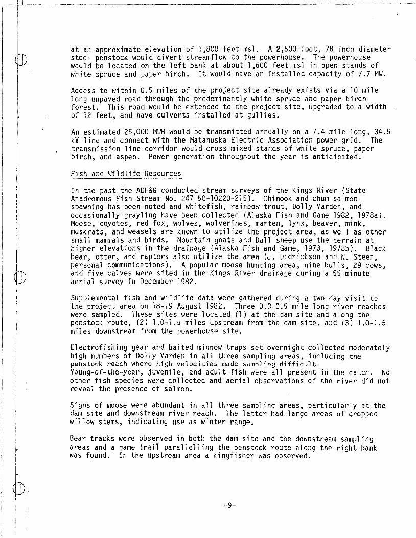
at an approximate elevation of 1,800 feet msl. A 2,500 foot, 78 inch diameter steel penstock would divert streamflow to the powerhouse. The powerhouse would be located on the left bank at about 1,600 feet msl in open stands of white spruce and paper birch. It would have an installed capacity of 7.7 MW.
Access to within 0.5 miles of the project site already exists via a 10 mile long unpaved road through the predominantly white spruce and paper birch forest. This road would be extended to the project site, upgraded to a width of 12 feet, and have culverts installed at gullies.
An estimated 25,000 MWH would be transmitted annually on a 7.4 mile long, 34.5 kV line and connect with the Matanuska Electric Association power grid. The transmission line corridor would cross mixed stands of white spruce, paper birch, and aspen. Power generation throughout the year is anticipated.
Fish and Wildlife Resources
In the past the ADF&G conducted stream surveys of the Kings River (State Anadromous Fish Stream No. 247-50-10220-215). Chinook and chum salmon spawning has been noted and whitefish, rainbow trout, Dolly Varden, and occasionally grayling have been collected (Alaska Fish and Game 1982, 1978a). Moose, coyotes, red fox, wolves, wolverines, marten, lynx, beaver, mink, muskrats, and weasels are known to utilize the project area, as well as other small mammals and birds. Mountain goats and Dall sheep use the terrain at higher elevations in the drainage (Alaska Fish and Game, 1973, 1978b). Black bear, otter, and raptors also utilize the area (J. Didrickson and N. Steen, personal communications). A popular moose hunting area, nine bulls, 29 cows, and five calves were sited in the Kings River drainage during a 55 minute aerial survey in December 1982.
Supplemental fish and wildlife data were gathered during a two day visit to the project area on 18-19 August 1982. Three 0.3-0.5 mile long river reaches were sampled. These sites were located {1} at the dam site and along the penstock route, (2) 1.0-1.5 miles upstream from the dam site, and (3) 1.0-1.5 miles downstream from the powerhouse site.
Electrofishing gear and baited minnow traps set overnight collected moderately high numbers of Dolly Varden in all three sampling areas, including the penstock reach where high velocities made sampling difficult. Young-of-the-year, juvenile, and adult fish were all present in the catch. No other fish species were collected and aerial observations of the river did not reveal the presence of salmon.
Signs of moose were abundant in all three sampling areas, particularly at the dam site and downstream river reach. The latter had large areas of cropped willow stems, indicating use as winter range.
Bear tracks were observed in both the dam site and the downstream sampling areas and a game trail parallelling the penstock route along the right bank was found. In the upstream area a kingfisher was observed.
-9-

I
~ I
~ i I
Discussion
Cursory field investigation indicate that Dolly Varden compose most, if not all, of the resident fishery within the immediate project area. Young-of-the-year and juvenile fish made up the majority of the catch, but some adults were also collected.
The absence of other species in the catch, while an important observation, is not entirely conclusive. The lack of definitive passage barriers to migratory fish moving upstream into the project area indicates that the river could provide habitat for other fishes. Chinook spawning season was completed several weeks prior to our mid-August visit and high water velocities are thought to have flushed any carcasses out of the river into the Matanuska River (D. Watsjold, personal communications). No surveys have ever been conducted along the Kings River during late September to document coho usage but Granite Creek (State Anadromous Fish Stream No. 247-50-10220-2105) with habitat similar to that of the Kings River has recorded runs of both chinook and coho salmon (D. Watsjold, personal communication). Fishery use data during an extended portion of the year are needed to evaluate project impacts to the aquatic resources, as they represent major data gaps.
On-site investigations suggest that moose make considerable summer use of the project area. All three sampling areas had tracks, left after high water had receded. In addition, the cropping of willow stems evidenced winter use at the downstream sampling area. The extent of the winter range varies from year-to-year depending upon the weather and snow depth (N. Steen, personal communication).
Bear use was noted in the vicinity of the dam site and the downstream sampling areas but cannot be quantified at this time. Thorough identifications of other wildlife species inhabiting the area is also needed. Indications of population size, and season and extent of habitat usage are important data gaps that must be filled before project impacts can be accurately assessed.
Some impacts of project features can be anticipated even though specific fish and wildlife data and engineering design information are not yet available. Installation of a dam and the dewatering of the penstock reach could have major adverse effects in the event that chinook and/or coho salmon migrate upstream into the project area. ADF&G 1 s Anadromous Fish Catalog indicates that chinook spawning occurs upstream to the approximate vicinity of the powerhouse site. The limit of fish use as shown in the catalog often coincides with the end of the survey and does not necessarily define the furthest upstream extent of actual fish use. Likewise, a two day field visit one time during the season does not provide conclusive evidence that the project area does not provide salmon habitat. Should further investigation reveal salmon use of the river in and upstream from the project area, they would be utilized as evaluation species for mitigation. Fish passage and instream flow releases would be mitigation measures considered for incorporation as project features.
The impoundment will inundate an undetermined amount of moose, bear, and furbearer habitat. Small mammals and birds may also use this area.
-10-

-~1 ,llf-1, -------------------~---------,----------1
I
Although the powerhouse site and transmission line corridor have not been identified, they are project features which would cause wildlife impacts. Major habitat changes would occur in the predominantly white spruce, paper birch, and aspen cover types with clearing, particularly for the transmission line corridor, and could have implications esp~cially for moose, bear, and raptors. The designation of a corridor adjacent to the access road would reduce these impacts.
Improved access to the site would be accompanied by secondary impacts to big game species, furbearers, and their habitat. Hunting of moose, mountain goats, Dall sheep, and perhaps bear presently occurs in the project drainage, but poor condition of the road limits access. Increased recreational use including greater harvests and habitat degradation can be anticipated with easier entry. Evaluation species such as moose, black bear, Dall sheep, wolves, mink, and/or raptors would be selected to analyze terrestrial impacts and develop a mitigation plan.
Recommendations I
On the basis of a reconnaissance level investigation of the project area, we make the following recommendations:
1. The transmission line should be placed adjacent to the road so that impacts are confined to one corridor.
2. The currently limited amount of fish and wildlife data should be supplemented in order to assess engineering design of various project features as it becomes available. The following kinds of information on fish and wildlife of the project area are still needed:
a. Identification of species composition and distribution of resident and anadromous fish both up- and downstream, as well as within the project area. Standard sampling methods such as minnow trapping and electrofishing, in addition to visual observation of spawning and/or redds, should be used;
b. Mapping of spawning, rearing, and overwintering habitats. The use of the FWS Instream Flow Incremental Methodology or similar procedures to describe these habitats may be appropriate;
c. Verification of the occurrence of wildlife. Data should include site-specific wildlife observations, including wildlife signs, denning sites, feeding sites, migration routes, winter use areas, and calving areas. Nesting surveys of raptors, including bald eagles, need to be conducted. The application of the FWS 1 Habitat Evaluation Procedure or the CEs 1 Habitat Evaluation System in analyzing habitat and populat1on information may be applicable; and,
d. Descriptions of vegetation and cover typing and determinations of the areal extent of each type, particularly along the transmission corridor and the powerhouse site.
-11-

_j__l__j_ __________________________________________ _ !
3. A plan to mitigate the loss of or enhance fish, wildlife, and associated habitat will need to be developed. Some of the features to be addressed include erosion control, revegetation, transmission line placement, powerhouse siting, and construction timing.
Study Area
PLACER RIVER Whittier, Alaska
The Placer River is located at the east end of the Turnagain Arm of Cook Inlet, Alaska, approximately 50 road miles from Anchorage along the Seward Highway. The river is glacially fed by Spencer, Deadman and Bartlett glaciers and numerous small ice fields. Annual precipitation levels for the area are unknown, but accumulated snowfall in the higher valley areas often exceeds twenty feet each year.
Beginning at the Placer River mouth and moving 10.5 miles upstream, the river valley gradually rises to the foot of Spencer Glacier and the steep foothills of the Kenai Mountain Range. Then the river rises sharply through a steep, narrow gorge where water velocities are swift and turbulent. The canyon walls diverge at the head of the gorge to form a 0.5 to 0.8 mile wide and 2 mile long valley. Within the valley, short segments of the river flow through alluvial fill forming raised terraces and bedrock gorges. The Placer River receives substantial flows (i.e., approximately 50 cfs) from a tributary originating from Bartlett Galcier approximately one mile upstream from the gorge. The river gradient continues to gradually rise to the headwaters at approximately the 1,600 foot contour.
The river bed within the valley is composed of large cobble and boulders and banks are unstable. The Placer River is typically clear until turbid flows from Bartlett Glacier discharge into the river. Downstream small gravel and glacial fines settle out as the river meanders.
Distinct vegetative communities in the project area are coastal sprucehemlock forest, shrub thickets, subalpine-shrub, and balsam poplar. Portions of the upper Placer River Valley have a floodplain that is heavily vegetated with b 1 ack cottonwood, wi 11 ow, alder and annua 1 s. Many terraced areas 1 in i ng the river have lush, herbaceously vegetated meadows consisting of fireweed, cow parsnip, false hellebore, several species of grasses and berry bearing shrubs.
Areas with greater topographic relief and higher elevations have stands of spruce and western hemlock while blueberry shrubs and ferns composed most of the understory. Rusty menziesia was also a commonly occurring shrub in the spruce/hemlock zone. Herbaceous and shrubby plants typical of alpine tundra were found growing in the interstices of bare rock and rubble.
-12-

I
I
~ I . I '
Project Description
The project area proposed by EBASCO (1982) is located on the Placer River between river miles 10.5 and 13.5. The diversion site is located immediately downstream of the river's confluence with a westerly tributary. A low arch dam, approximately 50 feet high, would divert stream flow into a bto mile-long penstock that would traverse the narrow gorge. The powerhouse would be located near Spencer Glacier at the mouth of the Placer River gorge and a transmission line would follow the Alaska railroad right-of-way.
As a result of the CE August 1982 field trip to the project area, four additional alternatives to EBASCO's have been proposed:
(1) A 30- to 40-foot dam placed one quarter mile upstream of EBASCO's dam site and upstream from the lower pair of abandoned railroad loop abutments would have a developed head of 60 feet. Ponding could total about 340 acre feet;
(2) A dam would be placed 250 feet upstream from the EBASCO site and, would be upstream from the westerly tributary feeding the river;
(3) A dam placed at the lower end of the gorge would have a diversion to a powerhouse 2,000 to 3,000 feet downstream from the location of the EBASCO powerhouse. A 500-foot railroad spur (rockcut) would be developed and transmission lines would run about eight miles along the railroad tracks to intertie with the Chugach Electric Association power line;
{4) A 50- to 70-foot high, 225 long dam placed about one mile downstream from EBASCO's dam site would create a 1,000 acre foot lake. Having a useable head of at least 45 feet, a 300-foot penstock would leave adequate room for a sluice and/or non-consequential sedimentation.
Any of the alternatives developed would be accessible via the Alaska Railroad. The CE believes that any one or all of the alternatives could probably be developed for peaking or regulated energy. It is also possible that a series of small dams could be constructed.
Fish and Wildlife Resources
Published papers and/or reports regarding biology of the specific project area are wanting. Most published reports limit themselves to the Placer River Valley {PRV) which encompasses only the lowermost portion of the project area.
Published fishery reports are entirely limited to the PRV. The Placer River drainage is specified as important to anadromous fish under AS 16.05.870 (Anadromous Fish Act). Known spawners are hooligan, Dolly Varden, rainbow trout and pink, coho and sockeye salmon. Principle salmon spawning and rearing areas in~lude Skookum Creek, Leubner Lake and clearwater branches of Spencer Glacier (State Anadromous Stream No. 247-60-10200). Baker {1977) reported that a U.S. Forest Service investigation in the vicinity of the
-13-
'.
b I . I I
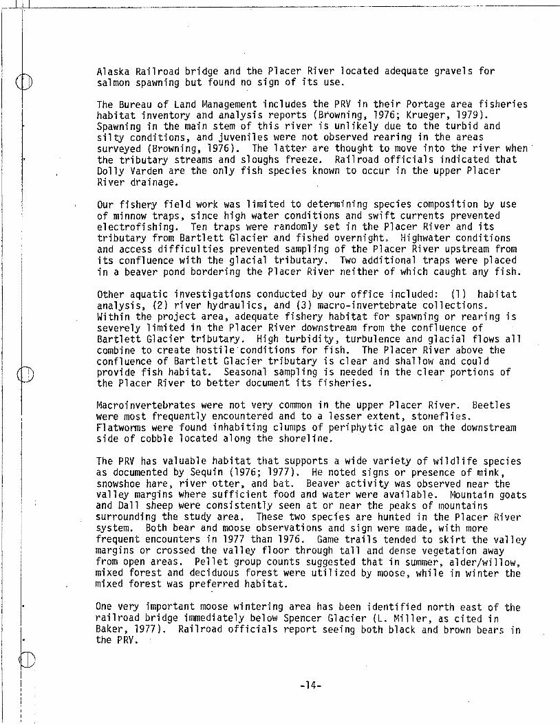
Alaska Railroad bridge and the Placer River located adequate gravels for salmon spawning but found no sign of its use.
The Bureau of Land Management includes the PRV in their Portage area fisheries habitat inventory and analysis reports (Browning, 1976; Krueger, 1979). Spawning in the main stem of this river is unlikely due to the turbid and silty conditions, and juveniles \'Jere not observed rearing in the areas surveyed (Browning, 1976). The latter are thought to move into the river when· the tributary streams and sloughs freeze. Railroad officials indicated that Dolly Varden are the only fish species known to occur in the upper Placer River drainage. ·
Our fishery field work was limited to determining species composition by use of minnow traps, since high water conditions and swift currents prevented electrofishing. Ten traps were randomly set in the Placer River and its tributary from Bartlett Glacier and fished overnight. Highwater conditions and access difficulties prevented sampling of the Placer River upstream from its confluence with the glacial tributary. Two additional traps were placed in a beaver pond bordering the Placer River neither of which caught any fish.
Other aquatic investigations conducted by our office included: (1) habitat analysis, (2) river hydraulics, and (3) macro-invertebrate collections. Within the project area, adequate fishery habitat for spawning or rearing is severely limited in the Placer River downstream from the confluence of Bartlett Glacier tributary. High turbidity, turbulence and glacial flows all combine to create hostile conditions for fish. The Placer River above the confluence of Bartlett Glacier tributary is clear and shallow and could provide fish habitat. Seasonal sampling is needed in the clear portions of the Placer River to better document its fisheries. ·
Macroinvertebrates were not very common in the upper Placer River. Beetles were most frequently encountered and to a lesser extent, stoneflies. Flatworms were found inhabiting clumps of periphytic algae on the downstream side of cobble located along the shoreline. ·
The PRV has valuable habitat that supports a wide variety of wildlife species as documented by Sequin (1976; 1977). He noted signs or presence of mink, snmvshoe hare, river otter, and bat. Beaver activity was observed near the valley margins where sufficient food and water were available. ~lountain goats and Dall sheep were consistently seen at or near the peaks of mountains surrounding the study area. These two species are hunted in the Placer River system. Both bear and moose observations and sign were made, with more frequent encounters in 1977 than 1976. Game trails tended to skirt the valley margins or crossed the valley floor through tall and dense vegetation away from open areas. Pellet group counts suggested that in summer, alder/willow, mixed forest and deciduous forest were utilized by moose, while in winter the mixed forest was preferred habitat.
One very important moose wintering area has been identified north east of the railroad bridge immediately below Spencer Glacier (L. Miller, as cited in Baker, 1977). Railroad officials report seeing both black and brown bears in the PRV.
-14-

_ _L~----------------~~--~-------------------------------------------------------------
I
(i~
Published literature, specifically related to the upper Placer River drainage, is wanting; however, personal accounts and observations are available from railroad employees and State biologists. D. B. Harkness (personal communication) reports that the area around Tunnel, Alaska receives little moose use during the winter. Wolves occasionally use the area during the summer, but winter use is probably not extensive because of harsh weather conditions. Mink, weasel, goat, sheep, lynx, brown and black bear, and wolverine have been sited in the upper project area.
During our field investigations 29-30 August 1982, wildlife sign and presence was limited. Beaver ponds were observed 200 to 300 yards upstream of the Alaska Railroad trestle. Small mammal trails were found crisscrossing the project area, though the extent and magnitude of trail use was not determined. Bear scats were occassionaly found in the terraced areas along the river.
Discussion
Preliminary field results indicate that any summer fishery in the main channel of the Placer River between Bartlett Glacier tributary and the railroad trestle is severely limited. Minnow trapping efforts yielded no fish; however, local residents report that Dolly Varden do reside in the river. The upper reaches of the Placer River, upstream from the confluence of Bartlett Glacier tributary, may act as a refuge for fish to avoid the turbid, turbulent waters of the lower reaches of the Placer River. More detailed field sampling is required in the upper Placer River to verify this inference.
Two physical parameters, one hydrological and the other geomorphical, heavily influence the fisheries of the upper Placer River. The Bartlett Glacier tributary influences the summer base flow of the river with increased flow, turbulence and turbidity. It is speculated that resident fish utilize the Placer River upstream from Bartlett Glacier in the summer. When these upstream reaches freeze during the winter fish are thought to seek refuge in the deeper, downstream portions of the main channel between the head of the gorge and the Bartlett Glacier tributary. However, geomorphic river characteristics which are conducive to a healthy fishery resource, such as rock islands, alluvial islands, mid-channel sand bars, side channels, chutes, backwater sloughs, are 1 ack i ng bebJeen the mouth of the gorge and the Bartlett Glacier tributary.
Recent research conducted in the Placer River Valley has confirmed that the Placer River supports a valuable anadromous fish resource; however, the uppermost reaches actually utilized by anadromous fish has not been delineated. We hypothesize that anadromous fish do not migrate upstream beyond Spencer Glacier into the project area. A steep and narrm~ river gorge between Spencer Glacier and Tunnel could act as an hydraulic chute and fish barrier. Impacts to any resident fish occurring within the project area can not be identified at this time due to the lack of field data.
The downstream environmental impacts associated with either a peaking or a regulated energy project design (series of small dams) are not clear. The contribution of the upper Placer River to the total flow must be identified in
-15-

order to understand its roll in supplying adequate flows to support downstream anadromous fish populations. Once this is clarified, then it can be determined whether or not the anadromous fishery of the Placer River Valley will be significantly effected by the project.
Few direct observations were made of wildlife in the project area and little information appears in the literature. Consequently, it is difficult to make definitive statements about the magnitude and extent of impacts expected to occur. However, because of severe winter conditions in the project area, very little moose browsing is likely to occur during that season. The lack of browsed vegetation within the project area appears to support this assumption. Black and brown bear and beaver may be the mammals most impacted by the project. Local residents and state biologists report large numbers of black bear in the project area.
All of the CE project alternatives will have some storage capacities. Since the degree and extent of storage is unclear, an estimate of the total habitat lost and/or number of large and small mammals displaced cannot be made. It is apparent that beaver ponds near the railroad trestle and at the confluence of the westerly tributa~ would be inundated and beaver would be displaced or eliminated from the area should storage be associated with this project. The ability of the surrounding habitat to absorb a displaced beaver population of undetermined size is not known.
EBASCO's suggested powerhouse site is located near Spencer Glacier, at the uppermost reaches of the Placer River Valley. Wildlife habitat in the vicinity is very conducive to supporting moose, bear and beaver. Both active and inactive beaver ponds were scattered throughout the area. Although raptors were not seen in the vicinity during our August trip, local residents report abundant sightings throughout the year.
Impacts associated with the penstock route are expected to be minimal and short term. During construction, local wildlife would be temporarily displaced but would afterwards be expected to return and use the area for feeding, nesting and/or as a traveling corridor.
Access to the general project area would be by rail. Roads may be built from the staging area, next to the railroad, to the vicinity of the diversion site; however, the presence of gorges near the diversion site may preclude roads and require the use of helicopters to transport equipment and construct the structure. Wildlife harassment and displacement is expected to occur as a result of such activity.
If substantial wildlife and anadromous fish populations occur within the project area, evaluation species would be selected for the purposes of developing a mitigat1on plan.
Recommendations
On the basis of a single reconnaissance level investigation of the project area, we make the following recommendations:
-16-

_ ___L!:I!_' L_~~-~~~---------::------------------,-----------------1
i
([)
I
1:. The currently limited amount of fish and wildlife data, should be
2.
supplemented in order to environmentally assess various engineering designs and project features. The following kinds of seasonal fish and wildlife information are still needed:
a. Identification of species composition and distribution of resident and/or anadromous fish both up- and downstream, as well a within the project area. Standard sampling methods such as minnow trapping and· electrofishing, in addition to visual observation of spawning and/or redds, should be used;
b. If anadromous fish are found to reside within the project area, mapping of spawning, rearing, and overwintering habitats will be needed. The use of the FWS Instream Flow Incremental Methodology or similar procedures to describe these habitats may be appropriate;
c. Verification of the occurrence of wildlife. Data should include site-specific wildlife observations, including wildlife signs, denning sites, feeding sites, migration routes, winter use areas, and calving areas. Nesting surveys of raptors, including bald eagles, need to be conducted. The application of the Fws• Habitat Evaluation Procedures or the CE 1 s Habitat Evaluation System in analyzing habitat and population information may be applicable; and
d. Description of vegetation and cover typing and determination of the areal extent of each type.
Descriptions of construction methods and project features which minimize damage to fish, wildlife, and associated habitat.
3. A plan must be developed to mitigate the loss of, or enhance fish, wildlife, and associated habitat. Some of the features to be addressed include erosion control, revegetation, transmission line placement, access routing, powerhouse siting, and constructi~n timing.
S;tudy Area
TONSINA RIVER TRIBUTARY Kenny Lake, Alaska
The site under investigation, a small unnamed tributary of the Tonsina River b;etween Dust and Liberty Creeks, is 1 ocated near the community of Kenny Lake, approximately 30 miles southeast of Glennallen. The tributary has its headwaters in mountain cirques at an approximate elevation of 4,700 msl and tlows into the Tonsina River at about 600 feet msl. Snowpack at higher e:l evati ons appears to be the primary source of flow; in mid-August 10-20 percent of the easternmost headwater stream was snow covered and snow banks remained in the cirques.
The six mile long creek drains a 7.8 square mile area and consists of a series of cascades throughout much of its length. Two major waterfalls occur within
-17-

~-__1_,!:,-L--------------~---------------------------~ ' I
(I~
I
I"
I I
rl:. \•
the canyon reach. A 17.3 cfs discharge measured in August gives an indication of the flow during summer months.
The alpine meadows surrounding the headwater streams gradually change to dense stands of alder adjacent to the creek, beginning in the vicinity of the confluence of the three streams that form the creek. Mixed deciduous vegetation, including alder and cottonwood, occur along the creek within the steep-wa 11 ed canyon, wh i 1 e white spruce predominate on the upper s 1 opes of the c:anyon and lower portions of the mountains. Near the mouth of the creek, ~tands of alder and willow, considerably less dense than upstream, occur on low benches and in former stream channels.
Project Description
The project as designed by EBASCO (1982) plans a 15 foot high, 200 foot long c:oncrete gravity dam located near the head of the canyon at approximately 2,400 feet msl. An impoundment of undetermined size would be created. A 6,300 foot, 12 inch diameter steel penstock would divert streamflow to the powerhouse at about 1,400 feet msl, where a 400 kW unit of two Pelton wheel turbines will generate power.
'
A six mile access road to the powerhouse site is a possible project feature. Access to the dam site and penstock route would be by either tramway or helicopter.
!
'
~n estimated 1,700 MWH will be transmitted annually on a three mile long, 14.4 k,V line across the Tonsina River and connect with the Copper Valley Electric A'ssoci ati on (CVEA) power grid. Excess power produced during warmer months w~ll be sold to CVEA displacing diesel generation. During the winter, power to the Kenny Lake community would come from the CVEA diesel generators, as the p~oject would produce no power.
Fish and Wildlife Resources
Although no studies of the project site were conducted prior to the initiation of this proposed project, the ADF&G has collected data on fish and wildlife in the general vicinity of the project stream (Alaska Fish and Game 1973, l978a, l978b, 1982). Chinook, coho, and sockeye salmon have been recorded in the Tonsina River (State Anadromous Fish Stream No. 212-20-10080-2331 ), while whitefish, grayling, burbot, lake trout, and Dolly Varden have been observed fn the Tonsina River drainage. In addition to a variety of small mammals, the p~esence of moose, caribou, Dall sheep, wolves, wolverines, marten, lynx, and m~skrats are residents of the project site and/or surrounding area. The project area is located within the Tonsina Management Area for sheep; access f~r hunting is restricted to walking (R. Tobey, personal communication).
Ai brief field visit to the project site provides a preliminary indication of the fish and wildlife resources of the area. Young-of-the-year chinook salmon, and a prickly sculpin were collected in baited minnow traps near the creek mouth and small Dolly Varden were caught 0.5-0.8 miles upstream. One chinook salmon redd near the water•s edge and adult chinook salmon were
-18-

I
~
r
observed in the Tonsina River at the mouth of the study creek; turbidity prevented observation of other redds. Adult chinook were not observed in the creek.
The canyon reach between the dam and powerhouse sites poses difficult access and made sampling virtually impossible in the time allowed. Baited minnow traps fished upstream from the dam site and in a headwater lake and stream captured no fish in overnight sets. Two waterfalls midway in the canyon block upstream fish movement.
Signs of moose, bear, coyote, and perhaps wolf were seen at the confluence of the creek and the Tonsina River. Moose sign were abundant and bear sign Common along the creek between the mouth and the powerhouse site. A number of birds, generally near the mouth, and red squirrels, between the Tonsina River ~nd the powerhouse site, were observed (Table 2).
Few wildlife observations were made upstream from the powerhouse site, as Mttle time was spent in this portion of the study area. However, game trails across the tundra were observed from the air and encountered while hiking from the upper slopes of the mountains to the dam site. Moose signs were a]so seen during the hike.
Discussion
Based upon limited sampling, at least several hundred meters of the downstream ~ortion of the creek provide rearing habitat for chinook salmon. Whether the young-of-the-year chinooks moved into the creek from the Tonsina River after hatching or were spawned in the creek cannot be ascertained with present qata. The absence of adult fish suggests the former possibility; however, the collection of young-of-the-year fish 300-400 meters upstream from the mouth, past cascades that represent significant upstream movement barriers to 40-50 mm fish, suggests the latter. Additional sampling is needed to determine which age classes of fish utilize the creek and the upstream limit of use.
Dolly Varden comprise another portion of the fishery which has not been defined. An estimated two miles of creek are potential Dolly Varden habitat, including approximately 0.5 miles along the penstock route. The absence of f:ish in collections made upstream from the dam site may indicate that no fishery occurs upstream from the falls.
Q1rect fishery impacts would result from dewatering the creek along the penstock route, assuming fish use extends upstream to the waterfalls. The fishery, not only in the creek, but also in the Tonsina River where Chinook,coho, and sockeye passage are known to occur (K. Roberson, personal communication), could be effected by the construction of an access road. lmpacts to Tonsina River fishery resources could potentially be greater than ~o those in the project creek. Depending upon the distribution of salmon in ~he project area and the method of access, chinook, coho, and/or sockeye salmon could be utilized as evaluation species for mitigation.
Preliminary on-site observations indicate that substantial wildlife populations may occur in the project area. Signs of moose and bear use were
-19-

( Table 2. Species list of biota observed during reconnaissance trip of the
Corps of Engineers• Kenny Lake small hydroelectric site, 9-10 August 1982
Classification
Phylum Chordata
Class Osteichthyes (Fish) Oncorhynchus tshawytscha Sa1velinus malma Cottus asper
Class Aves (Birds) Haliaeetus leucocephalus Pandion haliaetus
eryl e a 1 cyon C tes auratus Perisoreus canadensis Corvus corax Bombycilla garrulus Junco hyema 1 is Melospiza melodia
Class Mammalia (Mammals) Ursus sp. Cams l a trans Cams 1 upus Tamiasc1urus hudsonicus Alces alces
1/ Tracks and scats 2/ Tracks only
... 2Q,..,
Common Name
chinook salmon Dolly Varden prickly sculpin
bald eagle osprey belted kingfisher common flicker gray jay common raven bohemian waxwing dark-eyed junco song sparrow
bear l/ coyote Y wolf Y red squirrel moose 1/

I
l
particularly evident while coyote, wolf, red squirrel, and bird occurrences were also noted. Field work by ADF&G biologists confirm the diversity and abundance of wildlife species within the project area (R. Toby, personal communications).
In spite of the lack of precise engineering information, some impacts of project features can be anticipated. The placement of the penstock in the steep-walled canyon, while minimally affecting large mammals, could impact any raptor nesting on the rock outcropping of the gorge especially during construction. Impact beyond the time of construction would depend upon construction access and techniques utilized and the amount of habitat alteration needed to secure the penstock to the canyon wall.
Impacts, particularly to large mammals and raptors, could be caused by a 6 mile access road, a tramway, and a 3-mile long transmisson line corridor. All three project features would have both short and long term impacts associated with construction. Access into the area. which is presently infrequent, would cause secondary impacts, particularly to big game, anadromous fish, and perhaps furbearers from increased recreational and subsistence use. Based upon more specific wildlife data and detailed engineering design, a mitigation plan for the project would be developed utilizing selected large mammals, furbearers, and raptors and evaluation species.
Recommendations
On the basis of a reconnaissance level investigation of the project area, we make the fall owing recommendations:
1. Since a 6-mile access road and a tramway appear to be features potentially impacting fish, wildlife, and associated habitat for which alternatives do exist, a project design utilizing helicopter access or other access methods minimizing impacts to fish and wildlife is highly recommended.
2. The currently limited amount of fish and wildlife data should be supplemented in order to assess engineering design of various project features as it becomes available. The following k;-nds of information on fish and wildlife of the project area are still needed:
a. Identification of species composition and distribution of resident and anadromous fish both up- and downstream, as well as within the project area. Standard sampling methods such as minnow trapping and electrofishing, in addition to visual observation of spawning and/or redds, should be used;
b. Mapping of spawning, rearing, and overwintering habitats. The use of the FWS Instream Flow Incremental Methodology or similar procedures to describe these habitats may be appropriate;
c. Verification of the occurrence of wildlife. Data should include site-specific wildlife observations, including wildlife signs, denning sites, feeding sites, migration routes, winter use areas,
-21-

__ U~,~ L_~--~-------------------------------------------------------------------------
and calving areas. Nesting surveys of raptors, including bald eagles, need to be conducted. The application of the Fws• Habitat Evaluation Procedures or the cE•s Habitat Evaluation System in analyzing habitat and population. information may be applicable;
d. Compilation of historical and current harvest levels, in addition to subsistence use data, for anadromous and resident fish, and large mammals; and,
e. Descriptions of vegetation and cover typing and determinations of the areal extent of each type.
3. A plan to mitigate the loss of or enhance fish, wildlife, and associated habitat will need to be developed. Some of the features to be addressed include erosion control, revegetation, transmission line placement, powerhouse siting, and construction timing.
Study Area
WINDY RIVER Seldovia, Alaska
Windy River is located on the southern tip of the Kenai Peninsula, 15 miles east of the native village of Seldovia. The river is a tributary of Rocky River which in turn flows into Rocky Bay of the Gulf of Alaska. Annual precipitation is about 60 inches resulting in a mean streamflow of 40 cfs.
The source of the Windy River is located on the north slope of Red Mountain near the Kenai Chrome Mine. The river flows north between two ridges for four miles and then flows east two additional miles before discharging into the Rocky River. The uppermost four miles of the river has a variety of hydraulic conditions. Riffle-run sequences are most common. Turbulent hydraulic chutes, pools, and eddies occur near river bends and at most river constructions.
Stream width at the CE gauging site was 48.8 feet and 1.4 feet at maximum depth. Widths vary depending on the bank and bed composition, with width generally decreasing, and depth, velocity and turbulence increasing with the consoldiation of bed and bank materials. Two major falls exist within the study area. The largest is approximately 60 feet high at approximately 650 feet msl, and the other is approximately 15 feet high at 815 feet msl.
The Windy River vicinity has a coastal spruce-hemlock forest, which is characterized by tall and dense stands of Sitka spruce and western hemlock. Additionally, other conifers and black cottonwood are often interspersed with open treeless bogs. Alder, rus~ menziesia, willow, red alder, numerous species of berries, and devils club constitute the majority of the forest•s understory.
-22-

(1~.
~ I :
I : I
Project Description
EBASCO (1982) proposes that a ten foot high, 50 foot wide sheetpile diversion dam be locat~d in alluvial deposits at the 800 foot msl. A stairstep fish ladder type spillway would also be constructed. The 51 inch steel penstock would follow the northwest bank of the Windy River for 2,400 feet providing close to 200 feet net head. The powerhouse would be constructed near the intersection of the Windy River and Rocky River road. A 2.5 mile long transmission line would be constructed northwesterly from the powerhouse site and connect with Homer Electric Association powerlines.
Following the CE visit to the project site, two alternative dam designs were proposed, both using the EBASCO dam site. The first would have a length of 225 feet and a maximum height of about 35 feet while the second would be about 100 feet long and 20 feet high. A cut through the right side (facing downstream) of the rock point near the dam could be used for the penstock outlet. A penstock following the river appears to be uneconomical but a more gentle route along another gully could be utilized. This alternative route would intersect the Rocky River road about 500 feet downstream from the bridge over the ~~indy River and increase the penstock route to 2,900 feet.
Fish and Wildlife Resources
Published or recorded accounts of the fish and wildlife resources of the Windy River area are severely wanting. Therefore, our environmental analysis is based upon an on-site investigation conducted during 20-22 September 1982 and personal communications.
Field efforts to sample the fisheries of upper Windy River were unsuccessful because of frequent changes in river stage. Minnow traps placed in the river along a 300 yard stretch just upstream from EBASco•s diversion site were lost when the stage rose over one foot. Rock outcrops stripped of vegetation above the water surface and bent grass suggested that a recent stage had been over three feet higher. Electrofishing was considered unsafe because of high flow and turbulence.
A limited Dolly Varden sport fishery exists in segments of the Windy River parallelling the gravel road which connects Seldovia to the mouth of the Rocky River (T. R. Schroeder and H. Statler, personal communications). Local residents report that Dolly Varden are the only fish inhabiting the Windy River upstream of the diversion site (H. Statler, personal communication).
Other creeks and rivers in the vicinity of Windy River do have documented anadromous fish use. Jakolof Creek (State Anadromous Fish Stream No. 241-16-10040), a creek just north of Windy River, has pink and chum salmon spawning up to an elevation of 300 feet msl. Rocky River (State Anadromous Fish Stream No. 242-31-10120), the receiving waterway of the Windy River has pink, coho, sockeye and chum salmon spawning in its lower reaches below 150 feet msl. Numerous fish blocks and hydraulic chutes exist in the upper portion of Rocky River, however, and prevent anadromous fish from reaching the Windy River (T. R. Schroeder, personal communication). Sport fisherman also report
-23-

~_LI,~, L---------------~---------------------------------------------------------------1
(,D,
II · ~
I
~ I
'
b
spawning pink salmon upstream from the uppermost extent of the ADF&G's designated anadromous fish use area for the Rocky River (D. Ferrell, personal communication).
Specific wildlife information for the Windy River vicinity is limited, but a variety of large mammals are reported for the area (D. Holderman, personal communication). Both ridges east and west of upper Windy River provide good summer goat range. In September, a group of goats consisting of five individuals was seen on the west ridge of upper Windy River feeding on alpine herbaceous tundra. Goat counts made by ADF&G in Barbara Creek (Unit 863), one drainage area northwest of Win~ River, on 7 August 1982 found 29 adults and 5 kids. The most current count made in \~indy River (Unit 864) was in 1979 and identified 32 adults and 7 kids.
The Jakolof-Rocky River drainage represents some of the best moose habitat south of the head of Kachemak Bay (D. Holderman, personal communication). Three bulls were harvested between September 1 and 20, 1982. The Jakolof-Rocky River drainage offers prime black bear habitat. The area is traditionally hunted each year during the summer months. Brown bear are not common in the area but occassionally sited (D. Holderman, personal communication).
Dall sheep do not inhabit the Windy River drainage and the lynx population is very low. The lynx population is precluded from expanding because of the relatively low numbers of prey species in the drainage. Land otter, timber wolves and wolverines are reported in the Jakolof-Rocky River drainage but, their population status is unknown (D. Holderman, personal communication).
Little information is available regarding raptor use in the vicinity of the project area. Bald eagles reside and nest around Kachemak Bay and the uncommon golden eagle is suspected to inhabit the area. Substantiated sitings of the latter are rare.
Mitigation measures should be investigated and developed for evaluation species of black bear and mountain goat because of the impacts expected to occur to them should the project be developed. Additional information about the seasonal ranges of these species may alter the magnitude and extent of mitigation required.
Discussion
Available information indicates that several fish blocks exist downstream of the powerhouse site on the Rocky River and that a Windy River hydroelectric project would seem to have minimal impacts on the Rocky River anadromous fish populations. However, more hydrologic and fishery data are needed to make a conclusive statement.
The impacts of dewatering 2,500-2,900 feet of the Windy River by the penstock are not fully known because of the lack of fishery data. However, significant impacts to the resident Dolly Varden are not expected because severe hydrologic conditions in the reach are not conducive to supporting major
-24-

I I
CitD
populations. The absence of periphytic algae and macroinvertebrates also indicates that the habitat is not favorable for supporting major populations of Dolly Varden.
Impacts associated with the actual construction of the powerhouse and diversion structure are expected to be short term because of easy access by an existing road. Local mountain goat and black bear populations may be displaced and/or harassed temporarily. Construction of a penstock along the river bed as proposed by EBASCO would minimize impacts to local wildlife because the majority of habitat parallelling the stream is not conducive to supporting substantial large mammal populations, and segments of the river act as a movement barrier. However, construction through previously undisturbed forested areas would eliminate vegetation, alter natural physical shelters, harass wildlife and possibly act as a movement barrier. More in depth data analysis is needed to define the magnitude of these concerns.
The inundation area has been impacted by transient and abiding human activities. The river valley immediately upstream of the diversion site is made up of floodplain terraces. Livestock grazing in this area has effectively reduced plant biomass, altered plant population age structure and may have changed the species composition of the local communities. Anaconda Corporation is presently assessing whether or not to reopen the Kenai Chrome Mine located at the headwaters of Windy River, the impacts of which could exceed tllose associated with a hydroelectric project.
Recommendations
On the basis of a single reconnaissance level investigation of the project area, we make the following recommendations:
1. The currently limited amourit of fish and wildlife data should be supplemented in order to assess engineering design of various project features as it becomes available. The following kinds of seasonal fish and wildlife information are still needed;
a. Identification of species composition and distribution of resident and/or anadromous fish both up- and downstream, as well a within the project area. Standard sampling methods such as minnow trapping and electrofishing, in addition to visual observation of spawning and/or redds, should be used; ·
b. If anadromous fish are found to reside within the project area, mapping of spawning, rearing, and overwintering habitats will be needed. The use of the FWS Instream Flow Incremental Methodology or similar procedures to describe these habitats may be appropriate; and,
c. Verification of the seasonal occurrence of wildlife. Data should include site-specific wildlife observations, including wildlife signs, denning sites, feeding sites, migration routes, winter use areas, and calving areas. Nesting surveys of raptors, including
-25-
I' I: 11~~~------------------------------------~----------------------------~--------------
I
(~ipl· I •
2.
bald eagles, need to be conducted. The application of the FWS' Habitat Evaluation Procedures or the CE's Habitat Evaluation System in analyzing habitat and population information may be applicable.
A plan must be developed to mitigate the loss of, or enhance fish~ wildlife, and associated habitat. Some of the features to be addressed include erosion control, revegetation, transmission line placement, access routing, powerhouse siting, and construction timing.
SUMMARY
The five CE hydroelectric projects being studied in southcentral Alaska represent a variety of engineering designs in a variety of topographic and geographic areas. Although the environmental concerns for each project falls into similar categories, the extent and magnitude of concern will vary between sites. To address these concerns, data collection thorough enough to stand a legal or scientific test for both impact analysis and post-construction monitoring should be continued.
An impact matrix has been developed to help summarize all possible hydropower perturbations to ecosystem components and processes (Appendix B). Utilization of the matrix for each project selected for feasibility study will aid in identifying those attributes of the ecosystem needing to be measured and studied in future field efforts.
Major data gaps for all projects have already been identified. In general our primary concerns involve: (1) the distribution of resident and anadromous fish both up- and downstream, as well, as within the project area; (2) the seasonal occurrence of wildlife, and (3) the development of a plan to mitigate the loss of, or ~nhance fish, wildlife, and associated habitat. For all projects it is imperative that the scheduling and phasing of development activities reflect the time required to obtain and assess adequate environmental information.
-26-

(
(,
I
I •j I I I
·I
cp>:
REFERENCES CITED
Alaska Fish and Game Department. 1973. Alaska's Wildlife and Habitat. Vol. I.
1978a. Alaska's FisherY'Atlas, Vol. II.
1978b. Alaska's Wildlife and Habitat, Vol. II.
. 1982. An Atlas to the Catalog of Waters Important for ----~S~p-aw-n~,~n-g-Rearing and Migration of Anadromous Fishes. So~thcentral Region
2. Habitat Division, Resource Assessment Unit. April.
Baker, Robert. 1977. Staff Biologist;
State of Alaska, Department Fish and Game. Memo to files. October 7, 1982.
Regional
Browning, Randolph. 1977. Portage Area Fisheries Habitat Inventory and Analysis. 1976. Edited by Ross C. Kavanagh; Boulder, ,co= Western Interstate Commission for Higher Education. 92 pp.
Didrickson, John. 1983. Personal communication. State of Alaska, Department of Fish and Game, Palmer, Alaska.
EBASCO Services Incorporated. 1982. Regional Inventory and Reconnaissance Study for Small Hydropower Projects: Southcentral Alaska. Report submitted to Department of the Army, Alaska District, Corps of Engineers. June.
Ferrell, David. 1983. Personal communication. U.S. Department of the Interior, Fish an9 Wildlife Service. Anchorage, Alaska.
Harkness, D.B. 1983. Personal communication. State of Alaska, Department of Fish and Game, Anchorage, Alaska.
Holderman, David. 1983. Personal communication. State of Alaska, Department of Fish and Game, Homer, Alaska.
Krueger, S.W. 1979. Portage Area Fisheries Habitat Inventory and Analysis. 1977; edited by Larry Mangan, J. N. Mangus, Ross C. Kavanagh: -- Boulder, CO: Western Interstate Commission for Higher Elevations, 64 pp.
Rice, Kenneth. 1983. Personal communication. U.S. Department of Agriculture, Forest Service, Anchorage, Alaska.
Roberson, Kenneth. 1983. Personal communication, State of Alaska, Department of Fish and Game. Glennallen, Alaska.
Schroeder, T.R. 1983. Personal communication. State of Alaska, Department of Fish and Game, Homer, Alaska.
Sequin, R.J. 1976. Portage Wildlife Habitat Inventory and Analysis. WICHE program of Bureau of Land Management, Anchorage, Alaska. 75 pp.
-27-

__ u~~-----------------------------------
C)
I
1977. Portage Wildlife Habitat Inventory and Analysis. WICHE program of Bureau of Land Management, Anchorage, Alaska. 64 pp.
Statler, Herbert. 1982. Personal communication. Resident, Seldovia, Alaska.
Steen, Nicholas. 1983. Personal communication. State of Alaska, Department of Fish and Game, Palmer, Alaska.
Tobey, Robert. 1983. Personal communication. State of Alaska, Department of Fish and Game, Glennallen, Alaska.
Watsjold, David. 1983. Personal communication. State of Alaska, Department of Fish and Game, Anchorage, Alaska.
-28-

.
I
I I
I
APPENDIX A
Dangerous Cape Creek Small Hydroelectric Project Field Trip Report

I
I I
(~' I
UNITED STATES GOVERNMENT
memorandum TO:
FROM:
Files
U.S. FISH AND WILDLIFE SERVICE
1011 E. TUDOR RD. ANCHORAGE, ALASKA 99503
(907) 276-3800
Staff Biologist~(+ DATE' 18 FEB 1983
SUBJECT: Dangerous Cape Creek Small HYdroelectric Project (CE)
R7-3
INTRODUCTION
A reconnaissance trip to the Corps of Engineers (CE) Dangerous Cape Creek small hydroelectric site was made on 22 September 1982 by an interdisciplinary team consisting of the following:
Scott Shupe, CE, Project Manager Eddie Brooks, CE, Hydrologist lYnn Hornecker, CE, Foundation and Materials Guy McConnell, CE, Environmental ~1ayne Crayton, FWS, Ecological Services
STUDY AREA AND PROJECT DESCRIPTION
The site under investigation is located on the Kenai Peninsula, four to five miles directly north of Port Graham. Dangerous Cape Creek, the project tributary is approximately seven miles long and has a drainage area on 5.8 square miles. The diversion dam would be located at the confluence of tvJO smaller streams located at an elevation of 460 feet mean sea level. The general configuration of the creek chant1el was relatively straight and unbrai ded, as the very steep and narrmv canyon \'Ja 11 s prevent any meandering. Velocities measured by the CE 100 feet downstream from the confluence of the two smaller tributaries were approximately 60 cfs. Only one tributary from the north discharges into Dangerous Cape Creek between its mouth and the diversion site.
The entire 1 ength of the creek has varying sizes of gravel substrate 2 to 5 inches in diameter. Hydraulic chutes, found in the nar}·owest parts of the canyon, were formed by small boulders and cobble or downed spruce clogged with gravel and sand. Shallow pools were found in areas of low velocity and decreased slope.
The project area has a vegetative type consistent \'lith that of coasta 1 forests. The steep, rough topography has a narrow band of western hemlock and Sitka spruce along the stream course within the canyon. At higher elevations between the coastal forests and tundra, lie dense alder thickets with
A-2
3<!1.~-81

_ _LI!~·-~-------------------------------------------------------------------------------------, i
I I
!
I
'• I
I
I
herbaceous understories of devils club, salmonberry, fern, false hellebore and several species of grasses. Five-leaf bramble was most abundant on the northern facing forest floor.
The area upstream from the proposed diversion site is relatively flat. While Sitka spruce and western hemlock are most abundant, dense stands of alder line and overhang the creek. Moist tundra patches are interpersed throughout the area and become more frequent with higher elevations.
The powerhouse site is located in rough topography near the mouth of Dangerous Cape Creek. A very limited amount of flat area is available for constructing the powerhouse. Areas that do exist have sandy substrate and are subject to high surf from Cook Inlet. The installed capacity of the power staton would be 985 kW. Coastal spruce-hemlock forests dominate the area.
A penstock route would follow the north bank of the stream and would either be placed in the creek bed or be suspended from the canyon walls, or be a combination of both.
The proposed 6.1 mile, 14.4 kV/1 phase transmission line would follow the coastline to the communities of Port Graham and English Bay. Coastal spruce-hemlock forests constitute the majority of the transmission line corridor•s vegetation.
FIELD OBSERVATIONS AND INVESTIGATIONS
Access to the project area was by helicopter. Aerial reconnaissance of the creek and project area permitted observa~ions of vegetation and cursory identification of wildlife habitat.
Electrofishing for approximately 15-20 minutes at the diversion site (i.e., confluence of two streams) yielded only Dolly Varden. Wildlife signs were limited at the diversion site. Game trails crisscrossed the entire area, but neither mammal tracks and scats were found nor actual sitings made. An occassional dipper (water ouzel) was observed.
The majority of time in the field was spent hiking the penstock route and/or creek course. The three mile stretch of terrain was very rough and steep and inhibited our ability to sample the downstream fishery. Electrofishing efforts were limited to those sections crossed inadvertently. Dolly Varden were the only fish sampled, though the creek contains substrate conducive to supporting spawning anadromous fish populations and fish blocks were not found. However, hydraulic chutes and small log jams were observed.
Wildlife signs were not found in the vicinity of the powerhouse, and no tracks were seen on the sandy beach. However, game trails paralleled the creek between the diversion and powerhouse sites. Bear scats were very abundant, especially in the vicinity of berry patches.
A-3

b !
I
I I
I
~
DISCUSSION
Cursory field investigations indicate that Dangerous Cape Creek contains fishery habitat which is conducive to supporting anadromous fish populations. Local residents from English Bay/Port Graham report that pink salmon use Dangerous Cape Creek for spawning. The Alaska State Fish and Game Department anadromous fish catalogue (1982) indicates that pink, chum and coho salmon spawn in streams near the project area. More seasonally timed field trips are· needed to fully document the fishery resources of Dangerous Cape Creek. If anadromous fish do use the creek, instream flow releases may need to be incorporated into the operational plan for the project. In addition, some type of fish passage structure would be necessary to pass fish to the upper reaches of the creek.
Impacts to wildlife in the project area are anticipated, but significant amounts of field data needed to quantify the impacts are still wanting. Approximately three miles of adequate anadromous fishery habitat would be dewatered, as a result of penstock diversion. If the powerhouse were placed upstream of the areas anadromous fish use, no significant impacts would be expected to occur. The physical construction of the powerhouse would have short-term impacts on the local occurring wildlife. Impacts associated with the transmission line corridor cannot be discussed because field observations along the line were not made during this investigation.
A-4

___ _l._j,..-L--;--------------------------------------
1' !
(I~
APPENDIX 8 Small Hydroelectric Project
Impact Matrix
The U.S. Fish and Wildlife Service propo~~~ the use of a matrix in order to provide the fl~amework for collecting, synthesizing and analyzing information for the Corps of Engineers Southcentral Alaska small hydroelectric projects. Use of a matrix approach has the following advantages:}/
(1) Allows a wide view to be taken of the existing environment and the impending impacts on it;
(2) Provides a system which requires a multi-disciplinary approach to the identification and evaluation of specific impacts included in the analysis;
(3) Allows the diverse efforts of many specialist agencies to be coordinated;
(4) Requires users to make professional judgements and to document their opinion clearly;
(5) Demonstrates gaps in knowledge and therefore provides a basis for allocating .. research .. funds;
(6) Provides a system that is flexible and capable of being integrated into any kind of plannng context to either supplement or direct further analysis; and,
(7) Gives equal treatment to alternative proposals.
The impact matrix can be used to identify where impacts will occur and to estimate the relative magnitude and importance of individual perturbations on ecoystem components and processes. Many criteria should be considered in determining the magnitude and importance of a perturbation or effect~/. Determining the spatial extent and intensity of the perturbation and how long it will be present will delineate its magnitude. Understanding the extent of the effect on the ecosystem's components or processes will help to define its magnitude. Perturbations may set off a 11 Chain reaction .. of effects: first-order, second-order, and higher-order. First-order effects result
·directly from a perturbation. Second-order effects emanate from first-order, and so on.
Other criteria used in determining the magnitude and importance of a perturbation or effect is their relative persistence. The length of time it takes the natural system to recover from the disturbance is a factor. Short-term effects often have little impact on system dynamics, or they can be assimilated quite readily by the system. Long-term effects are generally more serious than short-term effects. They usually are detected at the population, community, or ecosystem level of organization, and they usually modify a system's functional or structural properties. Certain components are more important than others. If so, effects on these components, or on processes affecting these components, may warrent a higher ranking than would otherwise be given.
8-1

__ JJ . .--L..----~---~-----------,----------------
1
Cl~
C[D
Ranking impacts and assigning numbers are aacomplished by the following I stepwise procedure: I
1. Identification. Systematically scqn the column under each perturbation. Identify the potential impacts of each perturbation on components and processes affected by placing a small check mark 11 11
in a corner of the appropriate mattix cell.
2. Assign values to processes: A perturbation generally aff~cts a component through its effects on a !process. It is therefore necessary to evaluate the effects on processes first. In each process/perturbation cell containihg a check, assign a value (1-3) corresponding to your judgement of lthe magnitude and importance of the impact. Integer values, one tHrough three, are assigned as follows:
One - Effects occur but are of only slight concern; slightly important effects.
Two - Effects of moderate concern; moderately important effects.
Three - Effects are of particula~ concern; most important effects.
Blank - The perturbation has no dffect on the process or component.
3. Assign values to components: Afte~ the processes have been evaluated, assign values, to the impacts on each component. The value assigned to a component shoulld reflect the total impact of the perturbation on the component, including the effects on the processes that are most important to that co1ponent.
The values that you have assigned to each im,pact cell can now be summed to provide two relative measures of impacts. ]o obtain the total effect of all perturbations on any component or process, sum the impact rankings across the matrix. For the total effect of a single perturbation on all components and processes, sum the impact values for all components in the perturbation column. Do not include process scores from lthe column, since they are reflected in the assigned component values. I Major emphasis for future study should center on those perturbations, componlents and processes with the highest totals.
Since the evaluation of relative magnitude and importance of impacts is subjective, documentation of the procedure i~ important. Assumptions made in assigning numerical rankings should be recor~ed.
I,
I
I 1/ Fisher, D.W. and G.S. Davies. 1973. An approach to assessing
environmental impacts. Journal of Environmental Management 1:207-227.
21 I States, J.B., P.T. Haug, T.G. Shoemaker, L.W. Reed and E.B. Reed. 1978. A systems approach to ecological baseline studies. U.S. Fish and Wildlife Service, Office of Biological Services. FWS/OBS- 78/21.
I 392 pp.
B-2

SOIL HICRO AVIANS HAMMALS FLORA,MOSS-
ff;= ES/LICIIENS, >-l IIERB/WDY.PL t'l :;o
t:l 3: :;o S0 t:l 3: :;o S0 t:l 3: :;o ~;' .0 ..... 0 ro "'" 1-'· 0 ro "'" ..... 0 ro c: {I) , "0 ... -o {I) , "0 1-'.Q [J) , "0 ~ > "0 n ... ::>.: "d n ... ::>:E; "0 n ... t"" ro "' 0 rtrt ro "' 0 Mrt ro "' 0
~~ H " ,... 0. (!);:J'" ... ,... 0. (l);:l'" ... ,... 0. >-l {I) ..... " ::> en ..... " ::> en ..... " ...: Ill n n
~~ "' rt n "'"' "' n n ,... '< n ,_., '< n ::>::> ,... '< " .... flio. ..... no. ..... ~0. 0 0 ro 0 ::> ::> ::>
Appendix B.
Library
U.S. Fish fx \tVildlife Servic~ 1011 E. Tudor Road
Anchoraqe, Alaska 99503
t:l ..... {I)
"d ro ... {I)
Ill ,...
I
~~ •
() 0
FISH HACROIN- ZOO- MACRO- PERIPIIYTON PIIYTO- ~ 0 VERTEHRATES PLANKTON PIIYTES PLANKTON z t'l z >-l
3: ::0 S0 t:l 3: :;o S0 t:l 3: ::0 ~;' t:l 3: :;o S0 t:l 3: :;o s'"' t:l 3: :;o S0 0 f1) "'" ..... 0 ro "'" ..... 0 ro !-'· 0 ro "'" ..... 0 ro "'" ..... 0 ro ~8 "" , "d ~~
{I) , "0 1-'oO en ... "d ~-~ en ... "0 1-'<J {I) ... "0 1-'oO ~ ... "0 :;o
rT " "0 n ... ::> .; "0 n ... "0 n ... ::>.; "0 n ... ::>:E; n ... g:; 0
"' 0 ~;. ro "' 0 n rt ro Ill 0 ~;. ro "' 0 rtrt ro Ill 0 Mrt ro "' 0 () ,... 0. ... ,... 0. (l);:l'" ... ,... 0. ... ,... 0. (l);:l'" ... ,... 0. (l);:r" ... ,... 0. I; t'l ..... .: ~~ en ..... " ::> {I) ..... " {I) ..... " ::> en ..... " ::> {I) .... " "' rt n Ill n n '""' "' rt n
~~ Ill n n '"'" "' rt n Col~ p.:: n n "' '< n ,... '< rT ::>::> ,... '< n ,... '< n ::>::> ,... '< rT ::>::> ,... '< n t'l .... ~0. .... no. .... ..... no. .... no. ....
~0. "' 0 0 ro 0 0 ro 0 ro 0 ::> ::> ::> ::> ::> ::>
Vegetation destruction and removal
... -o t:l
Blasting and drilling 0 0 "' Ill ( 9 o. ro • en ,., - ;:l'"O.
Noise 0 ..... {I) " < " en ro ()
Temporary or "d ro ... 0 permanent "0 - en z 0 ..... "' access roads ,., n 0 >-l rt "' ::> :;o ..... c:
Dredge and fill "",... ()
"' ... ,......., n Ill 9 H ,...n-o 0
Stream crossings and/or t-oro 0 z ...... " modification n ::> > >-'· n 0.()
By-product removal storage ro ... 9 >-l {I) Ill ro H
and disposal ::> ::> < en n H 9 - >-l
Fuel storage .... H en -o t'l Ul ro "' 1-'o::l
Test drilling and 0 en ;l n
surveying 0 ,... n .... ,.. Borrow pits ;l
ro -Stuctural deterrents and/or >
() 0 barriers >-l "" H t'l Flow regulation and < ~ H drawdown >-l >-l
H H t'lO
Maintenance <nZ
Transient human activities > () >-lH
Recreational activities ~s HC: >-lO Ht'l
Hunting and fishing t'lCl
"' Secondary development
Impact matrix for small hydroelectric projects.