SOUTH JERSEY GAS – BL ENGLAND GAS ROUTE ... Documents/Attch 2a - Route...BL ENGLAND GAS ROUTE...
18
SOUTH JERSEY GAS – BL ENGLAND GAS ROUTE ANALYSIS REPORT 225616.00 South Jersey Gas Company June 18, 2012 woodardcurran.com COMMITMENT & INTEGRITY DRIVE RESULTS 609.448.8110 Dennis Walsh
-
Upload
dinhnguyet -
Category
Documents
-
view
218 -
download
3
Transcript of SOUTH JERSEY GAS – BL ENGLAND GAS ROUTE ... Documents/Attch 2a - Route...BL ENGLAND GAS ROUTE...

SOUTHJERSEY GAS –BL ENGLANDGAS ROUTEANALYSISREPORT
225616.00South Jersey GasCompanyJune 18, 2012
woodardcurran.comCOMMITMENT & INTEGRITY DRIVE RESULTS
609.448.8110Dennis Walsh
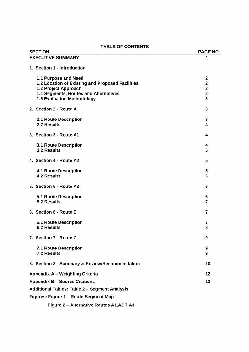
TABLE OF CONTENTSSECTION PAGE NO.
EXECUTIVE SUMMARY 1
1. Section 1 - Introduction
1.1 Purpose and Need 21.2 Location of Existing and Proposed Facilities 21.3 Project Approach 21.4 Segments, Routes and Alternatives 21.5 Evaluation Methodology 3
2. Section 2 - Route A 3
2.1 Route Description 32.2 Results 4
3. Section 3 - Route A1 4
3.1 Route Description 43.2 Results 5
4. Section 4 - Route A2 5
4.1 Route Description 54.2 Results 6
5. Section 5 - Route A3 6
5.1 Route Description 65.2 Results 7
6. Section 6 - Route B 7
6.1 Route Description 76.2 Results 8
7. Section 7 - Route C 9
7.1 Route Description 97.2 Results 9
8. Section 8 - Summary & Review/Recommendation 10
Appendix A – Weighting Criteria 12
Appendix B – Source Citations 13
Additional Tables: Table 2 – Segment Analysis
Figures: Figure 1 – Route Segment Map
Figure 2 – Alternative Routes A1,A2 7 A3

1
EXECUTIVE SUMMARY
South Jersey Gas (SJG) retained Woodard & Curran (W&C) to evaluate three different potential routes for theinstallation of a new 24” diameter steel pipeline (the “Project”) to supply natural gas to the existing Beesleys Pointcoal-fired electric generating plant located in Upper Township, Cape May County, commonly known as the B.L.England Generating Station (the “Facility”). The Project is necessary to convert the Facility from a coal to natural gasfueled generating plant. The new natural gas pipeline would originate either in Maurice River Township, CumberlandCounty or Hamilton Township, Atlantic County within SJG’s existing system, and would be installed largely beneathexisting State, County and local roads or an abandoned rail line. . Since the only feasible method to supply naturalgas to the Facility is via a pipeline, the Project is a necessary and essential component of the Facility repoweringproject.
To determine the overall preferred alternative route for the pipeline, W&C applied a utility-standard value ratingsystem adapted from the Electric Power Research Institute (EPRI) to evaluate the alternative routes using specificenvironmental, community, cultural, constructability and maintenance criteria. Three possible Supply Routes (SR)were evaluated, Route A, which approaches the Facility from the West and South, Route B, which approaches theFacility from the West and North, and Route C, which approaches the facility from the West and South, but along anabandoned rail corridor. In addition to limited field visits conducted by SJG and W&C staff, the evaluationincorporated "desk-top," publicly-available information related to possible environmental impacts, community andneighborhood impacts, constructability issues, and operation and maintenance issues.
Based on W&C’s overall analysis of these factors a variation of Route A, referred to as “Route A3,” was deemed tobe the best route. This alternative would involve construction of the pipeline within the Right-of-Way (“ROW”)beneath NJ Route 49 (East Main Street), starting at the intersection of NJ Route 49 and CR 671 (Union Road) inMaurice River Township, Cumberland County. The route would follow NJ Route 49 east about 12 miles to theintersection with Cedar Avenue. This NJ Route 49 segment would travel through Pinelands Forest Area within thepublic right-of-way for about 10 miles but would avoid the downtown area of the Village of Tuckahoe. The routewould follow secondary roads skirting the Village to NJ Route 50 and CR 662 (Tuckahoe Road). The route wouldfollow Tuckahoe Road for approximately 4 miles to Hudson Avenue and then to the Atlantic City Electric (“ACE”)electric transmission ROW and Beesleys Point Secondary rail line into the Facility. Route A3 would be installedalmost entirely beneath existing State and County road, power, or rail line and would have minimal environmentaland community impacts. By avoiding coniferous scrub forest, the Great Egg Harbor estuary, and city streets and bystaying within existing ROWs, Route A3 would yield less impact to the Pinelands ecosystem adjacent homeownersand the community as a whole, as there would be fewer disturbances to environmental resources, adjacent property(sidewalks, landscaping etc.) and facilities (pavement, utilities).
Route B, which would approach the Facility from the North, was rejected because of overall constructability issuesarising from the need to complete a horizontal directional drill (“HDD”) of nearly 7,000 feet beneath the Great EggHarbor estuary. This extraordinarily long and difficult HDD would present environmental risks and communityimpacts and would pose a risk of “fluid Frac-out” beneath the Great Egg Harbor estuary, which could impact benthicinvertebrates, aquatic plants and fish. Route B also would have significant community impacts because it wouldcause a major disturbance to homes along School House Road in Egg Harbor Township and would requiretemporary relocation of a dozen or more residents at Jefferson Landing on the Great Egg Harbor Bay.
Route C originates at the same starting point as Route A3 but would traverse the Forest Area along an abandonedrailroad corridor that is now heavily forested. Because this route would require extensive clearing of Pinelandsconiferous scrub forest that is habitat for the endangered northern pine snake, swamp pink, barred owl, Cope’s graytree frog, and frosted elfin, it was rejected.
Upon the acceptance of the A3 routing recommendation by SJG, W&C will begin detailed field environmental andcultural resource investigatory surveys, along with base mapping, and design drawings for the associated project

2
permitting submittals.
SECTION 1 – INTRODUCTION
1.1 Purpose and Need
BL England Power Plant is a coal-fired electric generating station that is owned and operated by RC Cape May
Holdings, LLC, an affiliate of Rockland Capital Energy Investments, in Upper Township, at the northern boundary of
Cape May County, New Jersey. BL England assumed responsibility for compliance with an existing Administrative
Consent Order (ACO) with the State of New Jersey and is pursuing the development of a new gas-fired combined-
cycle combustion turbine (CCCT) project at the existing power station in accordance with the ACO that will
significantly reduce air quality impacts and will ensure BL England continues to serve the power needs of southern
New Jersey. With the implementation of the gas-fired CCCT the generating station will convert from coal as its
primary fuel source to natural gas. Since there are no gas mains of sufficient capacity adjacent to the generating
station South Jersey Gas is proposing to extend a gas pipeline from the closest infrastructure with sufficient capacity
to serve the proposed gas-fired CCCT. The route selection study is being prepared to identify the most suitable route
to connect the existing delivery system with suitable capacity to the generating station.
1.2 Location of Existing and Proposed Facilities
The South Jersey Gas Transmission System that can supply the existing power plant located at Beesleys Point
exists to the west and north of the plant. The gas volumes and pressures required for the plant will necessitate
extending the existing 435 psig gas system to the plant. To meet the plant requirements, the proposed pipeline will
be a 24” steel natural gas pipeline with a Maximum Allowable Operating Pressure (MAOP) of 700 psig. Potential
routes for this pipeline would take it through the Pinelands and Coastal sections of New Jersey through residential,
commercial, industrial, and utility properties. Three primary potential routes have been identified for the new pipeline
as highlighted in MAP Figure #1.
1.3 Project Approach
The approach to the preliminary route assessments on this project involved a combination of desktop review, field
investigations, use of evaluation criteria, weighting factors, and other considerations to assist with assessing various
segments, routes and supply alternatives. Although the use of the weighting factors and the numerical values form
the basis of an objective approach to the route selection process, W&C also included an allowance for a subjective
input based upon the collective experience of the engineering and environmental personnel conducting the field
review.
1.4 Segments, Routes and Alternatives
To better manage the analysis of the various routing combinations, each route was divided into segments. Each
segment represents a subset of the route between the respective takeoff point from the existing gas system to the BL
England Power Plant. The segments are then compiled in various combinations to develop the potential routes.
Based on preliminary discussions with SJG, three independent primary routes were identified and reviewed for the
purpose of supplying natural gas to the BL England power plant. Later in the report, each route is described with its
length, location, benefits and potential conflicts.
3
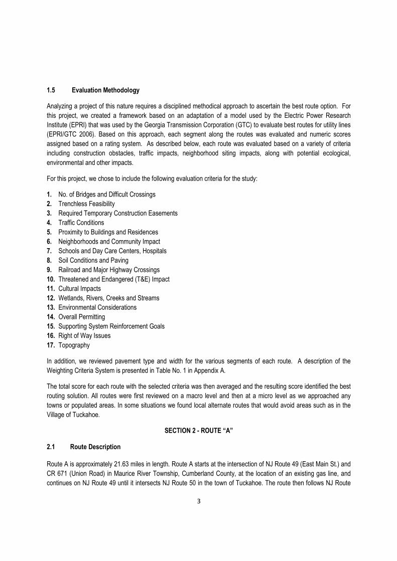
1.5 Evaluation Methodology
Analyzing a project of this nature requires a disciplined methodical approach to ascertain the best route option. For
this project, we created a framework based on an adaptation of a model used by the Electric Power Research
Institute (EPRI) that was used by the Georgia Transmission Corporation (GTC) to evaluate best routes for utility lines
(EPRI/GTC 2006). Based on this approach, each segment along the routes was evaluated and numeric scores
assigned based on a rating system. As described below, each route was evaluated based on a variety of criteria
including construction obstacles, traffic impacts, neighborhood siting impacts, along with potential ecological,
environmental and other impacts.
For this project, we chose to include the following evaluation criteria for the study:
1. No. of Bridges and Difficult Crossings
2. Trenchless Feasibility
3. Required Temporary Construction Easements
4. Traffic Conditions
5. Proximity to Buildings and Residences
6. Neighborhoods and Community Impact
7. Schools and Day Care Centers, Hospitals
8. Soil Conditions and Paving
9. Railroad and Major Highway Crossings
10. Threatened and Endangered (T&E) Impact
11. Cultural Impacts
12. Wetlands, Rivers, Creeks and Streams
13. Environmental Considerations
14. Overall Permitting
15. Supporting System Reinforcement Goals
16. Right of Way Issues
17. Topography
In addition, we reviewed pavement type and width for the various segments of each route. A description of the
Weighting Criteria System is presented in Table No. 1 in Appendix A.
The total score for each route with the selected criteria was then averaged and the resulting score identified the best
routing solution. All routes were first reviewed on a macro level and then at a micro level as we approached any
towns or populated areas. In some situations we found local alternate routes that would avoid areas such as in the
Village of Tuckahoe.
SECTION 2 - ROUTE “A”
2.1 Route Description
Route A is approximately 21.63 miles in length. Route A starts at the intersection of NJ Route 49 (East Main St.) and
CR 671 (Union Road) in Maurice River Township, Cumberland County, at the location of an existing gas line, and
continues on NJ Route 49 until it intersects NJ Route 50 in the town of Tuckahoe. The route then follows NJ Route

4
50 south to the intersection of Tuckahoe Road (CR 631). The route then follows Tuckahoe Road to US Route 9
(North Shore Road). US Route 9 is a major access road for the community. The final leg of Route A follows US
Route 9 north to Clay Avenue and continues west on Clay Avenue into the Plant. The route is shown in Figure 1,
Route Segments Map.
2.2 Results
Environmental
Route A is 21.63 miles long with approximately 3.60 miles of mapped wetlands adjacent to the route. Our review of
known threatened and endangered species/habitat along Route A identified numerous potential species at various
locations.
Route A has many historic resources within the study area. Specifically the area of downtown Tuckahoe includesresources very close to the road ROW.
Construction Considerations
Construction for the pipeline along Route A would mostly be open cut construction with numerous HDD’s or Jack &
Bores. Included in this would be a HDD under the railroad tracks on NJ Route 49 west of the Village of Tuckahoe
and another significant HDD under Cedar Swamp Creek along Tuckahoe Road. In addition, construction along US
Route 9 into the power plant would present numerous issues in terms of traffic flow and impact on the local
community.
Summary
Impacts to wetland areas adjacent to and within these ROWs could affect multiple species foraging and breeding
habitat; however, the proposed construction would be within previously filled and/or maintained ROWs. As a result,
wetland impacts should be minimal. Route A includes environmental resources that would require avoidance,
possible survey, special construction techniques and handling of contaminated soils encountered and permitting but
none of these issues would appear to represent significant obstacles considering the South Jersey Gas proposed
construction techniques.
SECTION 3 - ROUTE “A1”
3.1 Route Description
Route A1 is approximately 21.24 miles in length and is primarily a revision to Route A including the segments that
avoid the US Route 9 corridor. Route A1 begins in Millville at E Main Street & Union County Road (CR 671), at the
location of an existing gas line, and continues on to NJ Route 49 until it intersects NJ Route 50 in the town of
Tuckahoe. The route then follows NJ Route 50 south to the intersection of Tuckahoe Road (CR 631). The route then
follows Tuckahoe Road to the intersection with Church Road, then proceeds east on Tuckahoe Road to the
intersection of Hudson Avenue. The route then turns north on Hudson Avenue to the intersection with the Atlantic
City ROW, then east on the Atlantic City ROW to the intersection with the BL England property and continuing east to
the power station. The route is shown in Figure 2, Alternative Routes A1,A2 &A3.
5
3.2 Results
Environmental
Route A1 is 21.24 miles long with approximately 6.56 miles of mapped wetlands adjacent to the route. The
increased footage of wetlands adjacent to this route is primarily associated with wetlands adjacent to the route
between Tuckahoe Road and the power station. It is the intent of the project to avoid these wetlands through design
and trenchless construction techniques. Our review of known threatened and endangered species/habitat along
Route A1 identified numerous species. The revised section that extends from Church Road on Hudson Avenue, the
Atlantic City Electric ROW and onto BL England property includes unpaved ROW and approximately 1000 feet of
forested area. Construction techniques such as jack & bore will be utilized to avoid environmentally sensitive areas.
Route A1 has many historic resources within the study area as did Route A. There are numerous areas of knowncontamination within the study area of Route A1. These areas of known contamination are similar to Route A.
Construction Considerations
Much like the original Route A, Route A1 would mostly be open cut construction with numerous HDD’s or Jack &
Bores along NJ Route 49. Included in this would be a HDD under the railroad tracks on NJ Route 49 west of the
Village of Tuckahoe and another significant HDD under Cedar Swamp Creek along Tuckahoe road. However,
construction along US Route 9 into the plant would be avoided by using the Atlantic City electric ROW and the BL
England ROW into the plant. In that regard, construction along those ROW’s would be challenging and would require
avoidance of numerous wetlands, and removal and restoration of the railroad tracks in some areas, or the use of
HDD to circumvent sensitive areas. Overall, this last leg of the route is deemed to be a better option than installation
beneath US Route 9.
Summary
Impacts to wetland areas adjacent to and within these ROWs could affect multiple species foraging and breeding
habitat; however, proposed construction would be within previously filled and/or maintained ROWs. As a result,
wetland impacts should be minimal. Route A1 includes environmental resources that would require avoidance,
possible survey, special construction techniques and handling of contaminated soils encountered and permitting but
do not appear to represent significant obstacles considering the South Jersey Gas proposed construction techniques.
SECTION 4 - ROUTE “A2”
4.1 Route Description
Route A2 is approximately 22.14 miles in length. Route A2 is primarily a revision to Route A including segments that
avoid the NJ Route 50 downtown area of Tuckahoe. Route A2 begins in Millville at E Main Street & Union County
Road (CR 671), at the location of an existing gas line, and continues on to NJ Route 49 until it intersects Cedar
Avenue. Then south on Cedar Avenue to the intersection of CR 557. Then east on CR 557 to NJ Route 50. Then
South on NJ Route 50 for a very short distance to the intersection of Mt. Pleasant – Tuckahoe Road (CR 664). Then
south on Mt. Pleasant – Tuckahoe Road to the intersection of New York Avenue. Then east on New York Avenue to
NJ Route 50. Then south on NJ Route 50 to Tuckahoe Road. The route then follows Tuckahoe Road to US Route 9
(North Shore Road). US Route 9 is a major access road for the community. The final leg of Route A follows US

6
Route 9 north to Clay Avenue and continues west on Clay Avenue into the Plant. The route is shown in Figure 2,
Alternative Routes A1,A2 &A3
4.2 Results
Environmental
Route A2 has approximately 3.70 miles of mapped wetlands adjacent to the route. Our review of known threatened
and endangered species/habitat along Route A2 identified numerous species very similar to Route A.
Route A2 also has many historic resources within the study area as did Route A, but many identified historicresources on NJ Route 50 in downtown Tuckahoe would be avoided by Route A2. There are numerous areas ofknown contamination within the study area of Route A2. The areas of known contamination are similar to Route A.This includes thirteen (13) KCSL sites, three (3) ground water contamination areas, twenty six (26) regulated USTfacilities and several NJEMS sites.
Construction Considerations
Construction for Route A2 would be similar to Route A1, avoiding the downtown area of the Village of Tuckahoe. It
would still have the construction features of Route A and A1, with several HDD’s or Jack & Bores along NJ Route 49
and the one or two Jack & Bores under the same railroad tracks and a stream on Segment 2B, CR 567, but Route A2
would stay on US Route 9 like the original Route A. Hence, the impact of construction on the US Route 9 businesses
and community would still be significant.
Summary
This route is adjacent to wetland areas within these ROWs that could affect multiple species foraging and breeding
habitat; however, proposed construction would be within previously filled and/or maintained ROWs. As a result,
wetland impacts should be minimal. Route A2 includes environmental resources that would require avoidance,
possible survey, special construction techniques and handling of contaminated soils encountered and permitting but
do not appear to represent significant obstacles considering the South Jersey Gas proposed construction techniques.
SECTION 5 - ROUTE “A3”
5.1 Route Description
Route A3 is another variation of Route A and is approximately 21.75 miles in length. Route A3 is primarily a revision
to Route A including segments that avoid the NJ Route 50 downtown area of Tuckahoe and a segment that avoids
the US Route 9 corridor. Route A3 begins in Millville at E Main Street & Union County Road (CR 671), at the location
of an existing gas line, and continues on NJ Route 49 until it intersects Cedar Avenue. The route then continues
south on Cedar Avenue to the intersection of CR 557, then east on CR 557 to NJ Route 50; then south on NJ Route
50 for a very short distance to the intersection of Mt. Pleasant – Tuckahoe Road (CR 664); then south on Mt.
Pleasant – Tuckahoe Road to the intersection of New York Avenue; then east on New York Avenue to NJ Route 50.
Then south on NJ Route 50 to Tuckahoe Road; then east on Tuckahoe Road to the intersection with Church Road;
then east on Tuckahoe Road to the intersection of Hudson Avenue. The route then proceeds north on Hudson
Avenue to the intersection with the Atlantic City ROW, then goes east on the Atlantic City ROW to the intersection

7
with the BL England property and continuing east to the power station. The route is shown in Figure 2, Alternative
Routes A1,A2 &A3
5.2 Results
Environmental
Route A3 is 21.75 miles long with approximately 6.56 miles of mapped wetlands adjacent to the route Our review of
known threatened and endangered species/habitat along Route A3 identified numerous species. The revised section
that extends from Church Road on Hudson Avenue, the Atlantic City Electric ROW and onto BL England property
includes unpaved ROW and approximately 1000 feet of forested area. Construction techniques such as jack & bore
will be utilized to avoid environmentally sensitive areas.
Route A3 has many historic resources within the study area as did Route A, but many identified historic resources onNJ Route 50 in downtown Tuckahoe would be avoided by Route A3. There are numerous areas of knowncontamination within the study area of Route A3.
Construction Considerations
Construction for Route A3 would be similar to Route A with several exceptions. First, instead of an HDD under the
railroad ROW on NJ Route 49 just west of NJ Route 50, we would have one or two Jack & Bores under the same
railroad tracks on Segment 2B, CR 557. Second, instead of using US Route 9 and the resulting impact on the local
community, we would use the existing ACE and BL England ROW’s to go from Tuckahoe Road into the plant.
Construction along those ROW’s would require avoiding wetlands, may require removing and restoring existing
railroad tracks in some areas, or would require HDD to circumvent sensitive areas. Overall, this last leg of the route is
viewed as a better alternative to the Route 9 corridor.
Summary
Impacts to wetland areas adjacent to and within these ROWs could affect multiple species foraging and breeding
habitat; however, proposed construction would be within previously filled and/or maintained ROWs. As a result,
wetland impacts should be minimal. Route A3 includes environmental resources that would require avoidance,
possible survey, special construction techniques and handling of contaminated soils encountered and permitting but
do not appear to represent significant obstacles considering the South Jersey Gas proposed construction techniques.
SECTION 6 – ROUTE “B”6.1 Route Description
Route B would be approximately 10.5 miles in length. The route starts in Hamilton Township at CR 559 / Ocean
Heights Ave & Egg Harbor Road and travels in a southeastern direction on CR 559 until CR 575 / English Creek Ave.
At that point, the proposed main leaves CR 575 and follows School House Road to Somers Point / Mays Landing
Road. The route then follows Mays Landing Road to Morris Avenue. The route stays on Morris Avenue into Jefferson
Landings and finally a HDD of approximately 7,000 linear feet across Great Egg Harbor would be required to reach
the BL England Plant. The route is shown in Figure 1, Route Segments Map.

8
6.2 Results
Environmental
Our review of known threatened and endangered species/habitat along Route B identified numerous species. This
route includes work adjacent to tidal marsh and tidal waterways that may be impacted due to work area needed for
the extraordinarily long and difficult HDD crossing of the Great Egg Harbor Bay.
Route B does not have known significant historic resources within the study.
The long HDD across Great Egg Harbor Bay presents potential increased risk of “fluid Frac-out” in the estuary duringthe drilling process. Fluid Frac-out—the inadvertent return of drilling mud to the surface—is a potential concernwhenever the HDD technique is used under sensitive habitats and waterways. The HDD procedure uses bentoniteslurry as a drilling mud. A fluid frac-out occurring in the Great Egg Harbor estuary would have the potential tosuffocate benthic invertebrates, aquatic plants and other aquatic organisms. While drilling fluid frac-outs are always apotential with HDD’s, this exposure risk is increased on longer more difficult crossings such as the one proposedhere.
Construction Considerations
This route has several potential construction issues. There are numerous homes on School House Road that are less
than fifteen (15’) from the road, and the paving on the road leading from Jefferson Landings is only sixteen (16’) wide
which is the only access road to the homes located on the end of Jobs Point Rd. – Morris Ave. This route would
require 2 major HDD’s, one of which would be a technological challenge in the form of a long, difficult and complex
water crossing posing difficult construction issues and risk. The 7,000 foot larger crossing of Great Egg Harbor
requires 2 vertical and 1 horizontal curves in its design. During our preliminary route analysis, we considered drilling
from the plant side and from the end of Jobs Point Rd - Morris Ave. Either way would present issues. In the case of
drilling from the plant side, this would require using Jobs Point Rd. - Morris Ave for our laydown area. Jobs Point Rd -
Morris Ave is a very narrow, 16 foot wide paved area with year round homes located at the dead end. The terrain
drops off quickly into marsh areas so construction would be very difficult with extremely tight working conditions. It
would require the relocation of the residents during most of the construction period and especially during the final
welding and pipe pullback. Drilling from the Jobs Point - Morris Ave side would require either locating the drill rig up
on Jobs Point - Morris Ave essentially shutting off traffic flow or if the rig could be staged at the very end of Jobs
Point - Morris Ave., special permitting would be required due to the environmental considerations in that area.
In addition to the major HDD under Great Egg Harbor, an additional shorter HDD would be required on Jeffers
Landing Road just north of Jobs Point Rd. - Morris Ave. It will circumvent a bridge and marsh area. This would
require the drilling from the south and the laydown of the 24 inch steel pipe from the north. Again, the 24 foot wide
pavement makes for a very limited work area and adds difficulty to the project due to the extremely close marsh
areas along the perimeter of the pavement.
Summary
On the basis of all these considerations, Route B was rejected because of its overall constructability issues, and the
Horizontal Directional drill (“HDD”) of nearly 7,000 feet beneath the Great Egg Harbor estuary. This extraordinarily
long HDD would present environmental risks. Route B also would have significant community impacts because it

9
would cause a major disturbance to homes along School House Road in Egg Harbor Township and would require
temporary relocation of a dozen or so residents at Jefferson Landing on the Great Egg Harbor Bay.
SECTION 7 – ROUTE “C”7.1 Route Description
Route C is approximately 29 miles long. This proposed route starts at the same location as Route A, but deviates off
of NJ Route 49 to Port Elizabeth Road to the Conrail railroad ROW. From there, following the railroad ROW it travels
through the Town of Woodbine and then traverses either up CR 610 or continue over to US Route 9 and up US
Route 9 to the plant. This last option adds significant distance to the route. The route is shown in Figure 1, Route
Segments Map.
7.2 Results
Environmental
Our review of known threatened and endangered species/habitat along Route C identified numerous species. Route
C has many historic resources within the study area as did Route A. There are numerous areas of known
contamination within the study area of Route C.
Field inspection of the route discovered that significant miles of the ROW have gone through natural succession to
the point that this route could no longer be considered an improved ROW. The portion of the ROW that would
require tree and brush clearing for the pipeline includes habitat for barred owl, frosted elfin, northern pine snake,
swamp pink, Cope’s gray tree frog and Pine Barrens tree frog. Construction techniques such as HDD or jack & bore
could not be utilized to avoid the need to cut and clear numerous miles of this railroad ROW which would result in
unavoidable threatened and endangered species impacts.
Construction Considerations
The plan for this route was to follow the railroad ROW to avoid potential community impacts and crossing large
waterways/tidal wetlands. During the field inspection of this route, the railroad ROW was found to be revegitated by
understory and overstory species. There were also protected species identified in the reforested portions of the
railroad ROW. Single isolated sensitive areas could be circumvented by HDD, but field inspection of the route
discovered that miles of the ROW have gone through natural succession to the point that this route would no longer
be considered an improved ROW.
Summary
Based on a preliminary discussion with the Pinelands Commission Staff, and understanding the potential impacts to
protected species, wetlands, and cultural resources, it would appear that this route will not be a feasible alternative.
Hence, any considerations to employ trenchless construction techniques at isolated areas are not feasible at this
point and no viable route adjustments were investigated.

10
SECTION 8 - SUMMARY & REVIEW / RECOMMENDATION
Constructability Review / Ranking
Based upon the evaluation provided in this report, the alternate Route A3 is the preferred route. This alternate was
selected and is recommended for further study because it primarily uses existing public ROW, parallels the existing
Atlantic City Electric and BL England Rights-Of-Way, minimizes the distance it travels upon local city streets and
avoids the downtown area of the Village of Tuckahoe. The avoidance of city streets in Tuckahoe will yield less
impact to the adjacent homeowners and businesses in the downtown historic district area. Construction within
established Rights-Of-Way will also result in fewer disturbances to adjacent property (sidewalks, landscaping etc.)
and will therefore minimize the impact upon the community. This route also provides a secondary benefit to existing
SJG customers in Cape May County by providing an opportunity for a transmission system interconnect south of the
Village of Tuckahoe. Work along this route A3 should be closely coordinated with the NJ DOT and its planned
reconstruction efforts of the Tuckahoe River Bridge and Route 50 currently projected to start in 2013.
Route B is rejected because it would cause a major disturbance on School House Road in Mays Landing due the
close proximity of houses to the road which are less than fifteen feet away. The extraordinarily long HDD under the
Great Egg Harbor Bay, measuring approximately 7,000 feet in length, increases the risk exposure for a drilling fluid
frac-out in an unusually sensitive environment, and causes a major disturbance for the adjacent residents of
Jefferson Landing which would necessitate their relocation during the HDD operations.
Route C was also deemed not feasible early in the study as the selected path would require significant clearing and
grubbing of many miles of a reforested railroad ROW that is mapped as threatened and endangered species habitat.
The targeting of the pipeline on an abandon railroad ROW was a proposed alternative to avoid city streets and
disturbance of the local community, but the anticipated environmental impacts associated with this alternative far
outweigh the benefits resulting in the rejection of this route.
The ranking summary analysis shown below for the major routes is based on the project approach as defined in
Section 1.5 - Evaluation Methodology. Based on a review of the routing options, field observations, and identified
criteria, Route A3 is the route recommended for further study. A summary of the primary routes examined and their
respective scoring is provided in the table below.
Route Description SegmentsNo. of
SegmentsLength
(ft.)Length
(mi)Avg.
Points
A
Route A -originalroute on
Routes 49,50 & 9
1, 2, 2A,2H, 2F 3,3A,4 & 5 9 114,191 21.63 131.22
B Route B 15,16,17,18,19,20,22 7 55,425 10.50 119.29
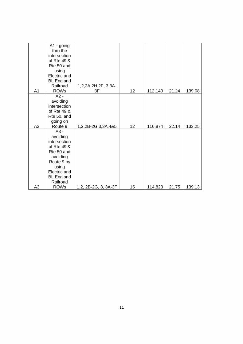
11
A1
A1 - goingthru the
intersectionof Rte 49 &Rte 50 and
usingElectric andBL England
RailroadROWs
1,2,2A,2H,2F, 3,3A-3F 12 112,140 21.24 139.08
A2
A2 -avoiding
intersectionof Rte 49 &Rte 50, and
going onRoute 9 1,2,2B-2G,3,3A,4&5 12 116,874 22.14 133.25
A3
A3 -avoiding
intersectionof Rte 49 &Rte 50 and
avoidingRoute 9 by
usingElectric andBL England
RailroadROWs 1,2, 2B-2G, 3, 3A-3F 15 114,823 21.75 139.13

12
APPENDIX A
Weighting Criteria

13
Appendix BSource Citations
• US Fish & Wildlife, New Jersey Field Office, Endangered Species Profiles and LifeHistories
http://www.fws.gov/northeast/njfieldoffice/• New Jersey Department of Environmental Protection, GIS data, Wetlands, Protected
Species Habitat, Environmental Sites, Streams, CAFRA boundaries, Historic andArchaeological Data
http://www.nj.gov/dep/gis/• U.S. Department of Agriculture, Natural Resources Conservation Services, Soil Mapping
of Atlantic, Cape May, and Cumberland Counties, NJhttp://soils.usda.gov/
• New Jersey Division of Fish and Wildlife, state protected species informationhttp://www.state.nj.us/dep/fgw/
• The Pinelands Commission, Pinelands boundary datahttp://www.state.nj.us/pinelands/landuse/gis/datas/
• US Geological Service, USGS 7.5 Minute Quadrangle Maps• United States Environmental Protection Agency (USEPA) databases• Additional project data from SJG

Table 2SEGMENT ANALYSIS
South Jersey Gas BL England Gas Supply Project
Route SectionLength
(ft)On Street(s) Starting at Ending at
No ofBridges/Difficult
Crossings
TrenchlessFeasibility
TempConstruc-tion
Easements
TrafficConditions
BuildingProximity
Neighborhoods& Community
Impact
Schools andDay CareCenters,Hospitals
Paved orUnpaved
Railroad &Major
HighwayCrossings
T&EImpact
CulturalImpacts
Wetlands,Rivers,Creeks,Streams
EcologicalConsiderations
Environ-mentalConsi-
derations
OverallPermitting
SupportingSystem
Reinforce-ment Goals
Right of WayIssues(LandAcquisition)
Topo-graphy
Over-allScoring
PavementType
PavementWidth
Major Facilities orLandmarks(Hospitals, FirstAid Squads, Schools, etc.)
Other Segment Comments
A 1 2,485 E Main St Union Rd (County Rd 671) Port Elizabeth Cumberland Rd 5 5 7 7 10 10 10 5 10 7 10 5 10 5 7 12 10 10 140 Asphalt 50 none
Cumberland Pond on north side of road;segment crosses Manumuskin River andassociated wetlands
A 2* 59,248 Rt 49 Port Elizabeth Cumberland Rd Rt 50 7 7 7 10 10 7 10 5 7 5 5 5 10 5 7 12 10 10 132 AsphaltVaries from
30+fire station
Sporatic facilities but the segment is 12 mileslong; not a major impact; Construction easementbased on water crossing; Tuckahoe River BridgeConstruction (rte 49 & 50) may be a factor forpipe installation. Significant amounts of wetlands,T and E habitat in study area; segment passesthrough 2 historic districts as well. *OriginalRoute A Segment 2 was 62,945' and changed to59,248' to compensate for the bypass of Route50.
A 2A 2,566 Rt 50 Rte 49 New York Ave 0 10 10 5 7 7 10 5 10 7 5 7 5 5 7 12 10 10 132 AsphaltVaries from
30+fire station
A 2H 3,697 Rte 49 Cedar Ave Rte 50 2 7 7 5 10 7 10 5 7 5 5 5 5 5 7 12 10 10 122 AsphaltVaries from
30+
A 2G 2,177 Cedar Ave Rte 49 County Highway 557 0 10 7 10 10 7 10 7 7 7 10 7 5 5 10 12 10 10 144 AsphaltVaries from
30+
A 2B 1,752 County Highway 557 Cedar Ave Reading Ave 2 7 7 7 10 7 10 7 7 7 5 7 5 5 7 12 10 10 130 AsphaltVaries from
30+
A 2C 1,706 County Highway 557 Reading Ave Mt Pleasant Road 0 10 7 7 7 7 10 7 7 7 5 5 5 5 7 12 10 10 128 AsphaltVaries from
30+
A 2D 2,262 Mt Pleasant Road County Highway 557 New York Ave 0 10 7 10 7 5 10 7 7 7 5 7 5 5 7 12 10 10 131 AsphaltVaries from
30+
A 2E 1,049 New York Ave Mt Pleasant Road Rte 50 0 10 7 10 10 7 10 7 7 7 5 7 5 5 10 12 10 10 139 AsphaltVaries from
30+
A 2F 7,443 Rte 50 New York Ave Rte 631 0 10 7 5 10 7 10 5 7 7 10 7 5 5 10 12 10 10 137 AsphaltVaries from
30+
A 3 11,676 Rt 631 Rt 50 County Highway 610 0 10 10 5 10 5 5 5 10 5 10 5 10 5 10 12 7 10 134 AsphaltVaries from
30+rescue squad center
extensive wetlands on both sides of road; longcrossing of Cedar Swamp Creek; large areas ofT and E habitat associated with creek andwetlands
A 3A 9,205 Tuckahoe Rd County Highway 610 @ Church Rd projection 1 7 7 5 10 10 10 5 7 7 10 7 10 5 7 12 7 10 136 AsphaltVaries from
30+
extensive wetlands on both sides of road
A 3B 2,292 Hudson Ave Church Rd ProjectionAtlantic City Electric (ACE) ROW @Holly Rd Projection
0 10 7 7 7 7 10 7 10 7 7 7 7 5 7 12 7 10 134Asphalt / Dirt
Road
A 3C 2,105 ACE ROW Hudson Ave and Ocean AveBL England Power Plant PropertyLine
0 10 10 10 10 7 10 10 10 7 10 5 5 5 7 12 10 10 148Dirt Road /
Grass
A 3D 7,009BL England Power Plant PropertyLine
BL England Power PlantProperty Line
End of ACE ROW @ West MapleShade Rd
0 10 10 10 10 10 10 10 10 7 10 5 5 5 10 12 10 10 154
A 3E 312Crossing BLEngland Property toRailroad ROW
End of Electric ROW Crossover BL England Railroad 0 10 10 10 7 7 7 10 10 7 7 7 5 5 10 12 10 10 144
Approximately 400 feet of Hudson Ave is paved,approx 1000 feet unpaved and overgrown, twominor wetland crossings on Electric ROW
A 3F 4,102 BL England Property Crossover BL England Plant 0 10 10 10 10 10 10 10 10 7 10 7 5 5 10 12 10 10 156 Elmwood Ave paved to Electric ROW
A 4 8,442 Tuckahoe Rd/ County Hwy 662 Church Rd N Shore Rd 0 10 7 5 7 5 5 5 5 10 10 7 5 5 7 12 7 10 122 AsphaltVaries from
30'+fire station
area of groundwater contamination (PCE andcarbon tetrachloride
AMosquito Landing Road/MiddletownRd/Woods Rd
Rt 50 Tuckahoe Rd 0 10-12'
Majority of length within public lands, StateTuckahoe Fish & Wildlife management area,would require Green Acres diversion and NJ Fish& Wildlife authorization. Not included in Analysis
A 5 9,429 N Shore RdCounty Hwy 662/ Old TuckahoeRd
Harbor Rd 0 10 7 5 7 7 7 5 7 10 5 10 5 5 7 12 7 10 126 AsphaltVaries from
30'+
area of groundwater contamination (PCE TCE);multiple historic properties near north end ofsegment
C 6 14,286 Port Elizabeth Cumberland Rd Rt 49 Railroad ROW 0 10 10 7 5 7 10 5 10 5 10 12 7 10 N/A Asphalt 22'
C 7 20,608 Railroad ROWRt 646/Port ElizabethCumberland Rd
Hunters Mill Rd 0 7 5 10 10 10 10 7 7 12 5 10 N/A n/a n/a
Abandon Railroad cars on track, Sandpit next torailroad, tracks have understory growth betweenrails east of abandon rail cars and east of pitsROW overgrown
C 7A 15,753 Railroad ROW Hunters Mill Rd Broad ST N/A n/a n/a Railroad ROW overgrown
C 7B 17,312 Upper Champion Rd/ Dehirsch Rd Broad ST Washington Ave n/a 5 5 10 10 10 10 10 5 12 5 5 N/A n/a n/aRailroad ROW maintained with varying width,This route goes thru Bellplain forest
C 7C 12,600 Dehirsch Ave/ County Hwy 550 Washington Ave Dennisville- Petersburg Rd 0 10 10 10 10 7 10 5 10 10 12 10 10 N/A AsphaltVaries from
30+NJ DOT training center, Municipal Airport,Overhead Rail Road
C 8 16,526Woodbine Oceanview Rd/ CountyHwy 550
Petersburg Rd Carsons Tavern Rd ( Rt 628) N/A
C 9 4,093 County Hwy 550 Carson Tavern Rd ( Rt 628) Shore Rd (Rt 9) N/A
C 10 10,651 Carson Tavern Rd ( Rt 628) Woodbine Oceanview Rd Rt 9 N/A
C 11 11,523 Shore Rd /Rt 9 County Hwy 550 County Hwy 628 N/A
C 11A 3,052 Shore Rd /Rt 9 County Hwy 628 W Katherine Ave N/A
C 12 2,627 W Katherine Ave Shore Rd / Rt 9 Old Stage Coach Rd / Rte 667 N/A
C 13 25,452 Shore Rd / Rt 9 W Katherine Ave N Shore Rd N/A
C 14 24,502 StageCoach Rd W Katherine Ave CR 662/ Old Tuckahoe Rd ` N/A
B 15 12,542 Ocean Heights Ave Egg Harbor Ave Rt 575 0 10 7 5 7 7 7 10 5 7 10 7 10 5 7 0 7 10 121 AsphaltVaries from
30+
B 16 10,735 Rt 575 / English Creek Ave Ocean Heights Ave School House Rd 0 10 7 5 5 7 10 10 5 7 10 7 7 5 7 0 7 10 119 Asphalt24, smallshoulders
B 17 8,613 School House Rd Somers Point/ Mays Landing Rd County Rd 575 0 10 7 5 1 5 5 10 10 5 10 7 5 5 7 0 7 10 109 Asphalt24', narrowshoulders
5+ T&E Species / Groundwater ContaminationPresent
B 18 3,959 Somers Point/ Mays Landing Rd Jeffers Landing Rd School House Rd 0 10 7 5 7 7 7 7 7 5 7 7 10 5 5 0 5 10 111 Asphalt24', narrowshoulders
6+ T&E Species
B 19 6,660 Jeffers Landing Rd Jobs Point Rd/ Morris Ave Somers Point/ Mays Landing Rd 1 7 7 7 7 10 7 10 10 10 10 5 10 5 7 0 7 10 129 Asphalt24', narrowshoulders
Potential Extensive Wetland Impacts
B 20 5,985 Jobs Point Rd/ Morris Ave Great Egg Harbor HDD Jeffers Landing Rd 0 10 5 5 5 7 10 10 10 10 10 5 10 5 5 0 5 10 122 Asphalt16', narrow
dirt shoulders
Potential Extensive Wetland Impacts
C 21 23,014County Road 610 (Dennisville -Petersburg Rd)
Dehirsch Ave County Road 631 (Tuckahoe Rd) 5 N/ANo analysis performed due to Route C FatalFlaw.
B 22 6,931 Great Egg Harbor HDD Morris Ave BL England Power Plant 1 5 5 10 10 10 7 10 10 10 10 5 10 5 5 0 5 7 124 None n/a
6/18/20126:58 PM

!(
!(
!(
!(
!(
!(
!(
!(
!(
!(!(
!(
!(
!(
!(
!(
!(
!(
!(
!(
!(
!(
!(!(
!(
!(
!(
!(
!(
!(
!(
!(
!(
!(
!(
!(
Tie in to Existing 24" PSIG Gas Main
#*
#*
Tie in to Existing 24" PSIG Gas Main
Segment 14
Segment 7
Segment 9
Segment 2
Segment 3Segment 5Segment 2A
Segment 4
Segment 3A
Segment 15
Segment 16
Segment 17
Segment 22
Segment 19
Segment 20
Segment 18
Segment 13Segment 21
Segment 8
Segment 7B
Segment 6
Segment 7A
Segment 7C
Segment 11
Segment 10
Segment 11A
Segment 9
Segment 1**Routes A and C
Segment 12
Figure 1: Route Segments MapProposed Gas Line to BL England Power Plant Atlantic, Cape May, and Cumberland Counties, New Jersey /
Data Source: Bing Maps
0 2 4 6 81 Miles
Legend!( Supply Route A!( Reinforcement Route A!( Supply Route B!( Supply Route C!( Reinforcement Route C
Existing 16 Inch 250 PSIG Gas MainExisting 20 Inch 350 PSIG Gas MainExisting 24 Inch 435 PSIG Gas MainExisting 24 Inch 700 PSIG Gas Main
BL England Power Plant
Route A
Route B
Route C

!(
!(
!(
!(
!(
!(
!( !(
!(
!(
!(
!(
!(
!(
!(
!(
!(
!(
!(
!(
!(
!(
!(
!(
!(
!(
!(
!(
!(
!( !(
!(
!(
!(
!(!(
#*
Tie in to Existing 24" PSIG Gas Main
Route A
Segment 2C
Segment 2F Segment 4
Segment 5
Segment 2G
Segment 2B
Segment 2H
Segment 2E
Segment 2
Segment 2A
Segment 3 Segment 3A
Segment 3D
Segment 3F
Segment 1
Segment 3B
Segment 3C
Segment 3E
Figure 2: Alternative Routes A1, A2, A3Proposed Gas Line to BL England Power Plant Atlantic, Cape May, and Cumberland Counties, New Jersey /
Data Source: Bing Maps
0 2 4 6 81Miles
Legend!( Reinforcement Routes A1, A2, A3!( Route A1!( Route A2!( Route A3
Existing 24 Inch 435 PSIG Gas Main
!(
!(
!(
!(
!(
!(
!(
Segment 3
Segment 3A
Segment 2A
Segment 3D
Segment 3F
Segment 3B
Segment 3CSegment 3E
Detail of Route A1
!(
!(
!(
!( !(
!(!(
Segment 2F
Segment 2D
Segment 2G
Segment 2C
Segment 2B
Segment 2E
Detail of Route A2