South Humber Gateway Mitigation Delivery Plan … · South Humber Gateway Mitigation Delivery Plan...
53
South Humber Gateway Ecological Mitigation North East Lincolnshire Delivery Plan September 2016
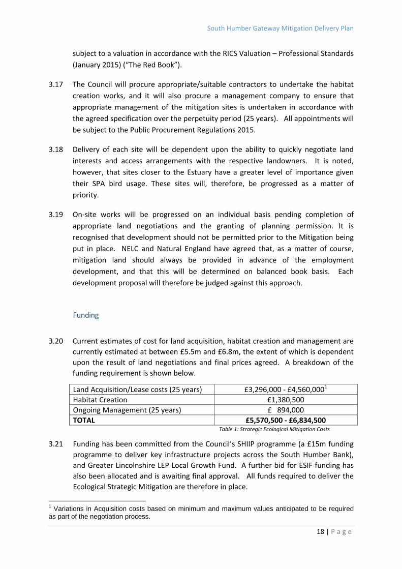
Transcript of South Humber Gateway Mitigation Delivery Plan … · South Humber Gateway Mitigation Delivery Plan...

South Humber Gateway Ecological Mitigation
North East Lincolnshire Delivery Plan
September 2016

South Humber Gateway Mitigation Delivery Plan
2 | P a g e
CONTENTS
1.0 Executive Summary Page 3
2.0 The Strategy Page 4
Context
Approach to site selection
Preferred Sites
3.0 Delivery Plan Page 11
Site specific proposals
Phasing and Delivery
Funding
Programme
Monitoring and Management
4.0 Conclusions Page 19
Appendix 1: Memorandum of Understanding (June 2010) Page 22
Appendix 2: Site Options Assessment Page 30
South Humber Gateway Mitigation Delivery Plan
3 | P a g e
1.0 Executive Summary 1.1 The South Humber Gateway (SHG) is located on the south bank of the Humber
estuary in northern Lincolnshire. Covering an area of approximately 1,000 hectares,
it represents one of the largest potential development areas in the UK. In recent
years there has been significant development interest in the area particularly from
the emerging renewable energy industry on the Humber.
1.2 The area is immediately adjacent to the Humber Estuary, which is recognised for its
importance for wildlife at both national and international levels. The Humber Estuary
is designated as a Special Area of Conservation, a Special Protection Area, a Ramsar
site and a Site of Special Scientific Interest. These designations mean that great care
is required when undertaking works which may result in negative impacts on the
wildlife interest features of the Estuary. A potential conflict therefore exists between
the need to develop the South Humber Gateway’s economic potential for the benefit
of the national economy and the legal obligation to ensure that its wildlife is
protected.
1.3 This document sets out a mechanism, which will resolve the potential conflicts within
the South Humber Gateway. In addition to providing details on the background to
the strategy and the principles upon which it is founded, it seeks to identify the
preferred mitigation sites for the North East Lincolnshire area, the proposals
associated with them and provide details of the approach to their implementation
and delivery. Proposals for delivery within North Lincolnshire have been prepared
separately.
South Humber Gateway Mitigation Delivery Plan
4 | P a g e
2.0 The Strategy
Context
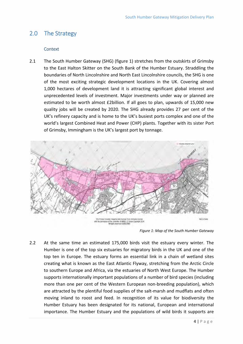
2.1 The South Humber Gateway (SHG) (figure 1) stretches from the outskirts of Grimsby
to the East Halton Skitter on the South Bank of the Humber Estuary. Straddling the
boundaries of North Lincolnshire and North East Lincolnshire councils, the SHG is one
of the most exciting strategic development locations in the UK. Covering almost
1,000 hectares of development land it is attracting significant global interest and
unprecedented levels of investment. Major investments under way or planned are
estimated to be worth almost £2billion. If all goes to plan, upwards of 15,000 new
quality jobs will be created by 2020. The SHG already provides 27 per cent of the
UK’s refinery capacity and is home to the UK’s busiest ports complex and one of the
world’s largest Combined Heat and Power (CHP) plants. Together with its sister Port
of Grimsby, Immingham is the UK’s largest port by tonnage.
Figure 1: Map of the South Humber Gateway
2.2 At the same time an estimated 175,000 birds visit the estuary every winter. The
Humber is one of the top six estuaries for migratory birds in the UK and one of the
top ten in Europe. The estuary forms an essential link in a chain of wetland sites
creating what is known as the East Atlantic Flyway, stretching from the Arctic Circle
to southern Europe and Africa, via the estuaries of North West Europe. The Humber
supports internationally important populations of a number of bird species (including
more than one per cent of the Western European non‐breeding population), which
are attracted by the plentiful food supplies of the salt‐marsh and mudflats and often
moving inland to roost and feed. In recognition of its value for biodiversity the
Humber Estuary has been designated for its national, European and international
importance. The Humber Estuary and the populations of wild birds it supports are
South Humber Gateway Mitigation Delivery Plan
5 | P a g e
afforded special protection being designated at national and international levels. The
estuary includes several Sites of Special Scientific Interest (SSSI) and is designated as
a Special Area of Conservation (SAC)1, Special Protection Area (SPA)2 and Ramsar
site. As such, both the estuary and its special features are covered by The
Conservation of Habitats and Species Regulations 2010 (the “Habitats Regulations”)
(SI No. 2010/490) as amended.
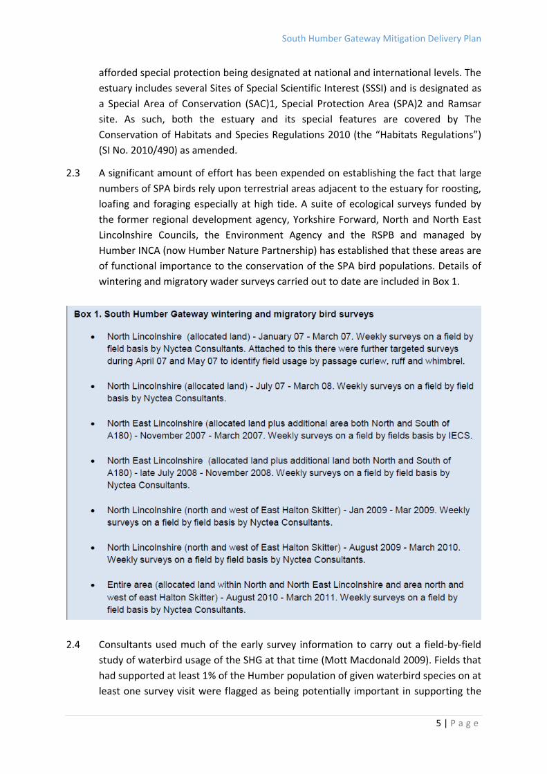
2.3 A significant amount of effort has been expended on establishing the fact that large
numbers of SPA birds rely upon terrestrial areas adjacent to the estuary for roosting,
loafing and foraging especially at high tide. A suite of ecological surveys funded by
the former regional development agency, Yorkshire Forward, North and North East
Lincolnshire Councils, the Environment Agency and the RSPB and managed by
Humber INCA (now Humber Nature Partnership) has established that these areas are
of functional importance to the conservation of the SPA bird populations. Details of
wintering and migratory wader surveys carried out to date are included in Box 1.
2.4 Consultants used much of the early survey information to carry out a field‐by‐field
study of waterbird usage of the SHG at that time (Mott Macdonald 2009). Fields that
had supported at least 1% of the Humber population of given waterbird species on at
least one survey visit were flagged as being potentially important in supporting the
South Humber Gateway Mitigation Delivery Plan
6 | P a g e
waterbird assemblage of the Humber Estuary SPA. 454 hectares of such fields were
identified across the SHG in North and North East Lincolnshire. However, this
resource was clearly highly variable, with some fields only being used on a few
occasions, and other fields being used regularly by significant numbers of one or
more species. Habitats used varied from arable crops that might only be used at
certain stages of growth or vegetation height to areas of permanent pasture that
might be used more predictably from year to year.
2.5 The development of all or most of the SHG area is considered likely to lead to a
significant loss of this supporting terrestrial habitat and it is not possible to conclude
that an adverse effect on the integrity of the SPA will be avoided. The Conservation
of Habitats and Species Regulations 2010 require that, where there are reasons of
“overriding public interest” (including both social and economic issues), proposals for
development that will have a negative impact upon the integrity and sustainability of
the site must have appropriate mitigation measures in place prior to planning
permission being supported.
2.6 It was determined that the most effective course of action in the SHG was to identify
large areas of land which can be used to mitigate against the loss of land currently
used by waders. In order to deliver this strategic mitigation, a South Humber
Gateway Ecology Group was formed comprising local authorities, landowners and
both statutory and non‐statutory conservation bodies.
2.7 A Memorandum of Understanding (MOU) was prepared and signed by each of the
parties within the SHG Ecology Group in June 2010. This demonstrated the
commitment of all parties to cooperative working to the production, adoption and
implementation of a framework to address the ecological and economical demands
upon the Estuary. The signatories agreed to a strategic approach to delivery,
believing this to be more preferable to piecemeal implementation, and that positive
planning reduces ad hoc loss and speeds decision making. The objectives for the
approach identified are detailed in Box 2, and a full copy of the MOU is enclosed at
Appendix 1.

South Humber Gateway Mitigation Delivery Plan
7 | P a g e
Box 2. Objectives for Strategic Mitigation Approach
To identify strategic conservation mitigation options through an agreed Delivery Plan, which will form part of the Local Development Frameworks for both North Lincolnshire and North East Lincolnshire Council.
To ensure that the Delivery Plan and the emerging LDFs comply with the Habitat Regulations and are subject to the relevant Regulations 61,62 and 66.
To examine the need and nature of Strategic Environmental Assessment for the LDFs.
To acknowledge that both the LDF and Delivery Plan for strategic mitigation will be delivered over a period of time and work together to establish these timescales with agreement over what will need to be delivered to meet environmental requirements.
To identify implementation and financial mechanisms for utilising the strategic mitigation that provide a clear process for development to address the issue of direct land take of areas used by SPA and Ramsar birds within the SHG.
To ensure the Delivery Plan takes into account the implementation of the approved Humber Estuary Flood Risk Management Strategy and subsequent reviews, recognising that there are intertidal issues.
To agree that mitigation areas identified by the Delivery Plan and associated LDF.
Allocations documents will be delivered both within the SHG Employment Allocation zone and in close proximity outside this zone, as currently adopted.
To meet the requirements of PPS9 to build in biodiversity to all developments.
To examine and agree the evidence base to support the development and implementation of the Delivery Plan, including Identifying the location and extent of existing critical land areas for avifauna – identified through bird survey work.
To agree the area where the Delivery Plan will operate, supported by an agreed evidence base, including optimal management guidelines and basic design principles to ensure that mitigation areas function appropriately.
To agree the basis for the ownership and management of mitigation sites, how contributions are worked out and methods of making contributions (S106 agreements/CIL etc) as well as how they will be used and how mitigation sites will be managed and by whom.
To agree requirements for monitoring and review of the Delivery Plan and the mitigation areas.
To share data and to work together to ensure that data are interpreted in a consistent manner by developers and regulators
South Humber Gateway Mitigation Delivery Plan
8 | P a g e
2.8 The work proceeded outlining a series of general principles that would give a broad
picture of what a final solution would likely look like. The principles identified in Box
3 were utilised to assess the requirements.
2.9 It was concluded that, in order to mitigate for 454ha within the SHG area, four 20ha
blocks of core wetland habitat, each surrounded by 150m wetland habitat buffers,
would be sufficient to offset the potential loss of proposed development land. These
should be located in close proximity to key intertidal feeding areas. These criteria led
to the identification of a requirement for two of the above blocks to be provided in
North Lincolnshire and two within North East Lincolnshire.
2.10 Further discussion relating to North East Lincolnshire led to agreement on an
approach, which will see the delivery of a number of sites smaller than the proposed
buffered 20ha sites. These sites will provide a network for birds, which reflects how
birds are currently using the area. Whilst some of these sites are too small to
function as mitigation alone, they are ecologically functional as part of the suite of
mitigation sites. These were subsequently taken further and a set of Mitigation
Principles have been developed and embodied in the Delivery Plan, as detailed in
Box 4.
BOX 3. Strategic Mitigation: General Principles
Continued unmitigated development of the SHG will cause adverse effects on the
integrity of the Humber SPA and Ramsar site
It is highly unlikely that all adverse effects can be mitigated outside the SHG
Given the size and length of the SHG a single mitigation site would not represent an
acceptable solution
The total area of mitigation will likely be less than the combined area of land used by
birds, provided the mitigation is appropriately located, designed and managed
There are likely to be areas in the SHG used in such large numbers that their loss alone
or in combination with other development in the area constitute an adverse effect on
the integrity of the Humber SPA and Ramsar site
The pattern of bird use may indicate areas that subject to the right mitigation could
support higher levels of use and may be suitable for mitigation
Some areas of the SHG not be used by birds may be affected by factors such as crop
regimes rather than locational factors
South Humber Gateway Mitigation Delivery Plan
9 | P a g e
BOX 4. Strategic Mitigation: Mitigation Principles
Area (combined):
The mitigation required to enable continued development of the SHG will need to be
sufficient to support the needs of the birds using the inland areas of the SHG and intertidal
areas. Data collected through the HINCA coordinated surveys suggests that the SHG
supports more than 1% of golden plover, lapwing, curlew, whimbrel and ruff on c.454ha of
the available c.1000ha – the creation of optimal mitigation would therefore need to
mitigate for the loss of the 454ha of land.
Area (individual):
The size of individual mitigation areas will need to take account of species and numbers of
birds to be accommodated, preferred roosting densities, scanning requirements,
disturbance effects and viable management. Calculations suggest that to create a 20ha
core refuge, allowing for minimal edge effect equating to a minimum 150m sub optimal
area of habitat to absorb edge effects, the overall mitigation site area would be 50ha. To
achieve confidence in ecological functioning a minimum of four mitigation areas are
required within the SHG
Location:
Mitigation must be located within appropriate distance of the intertidal areas, other
mitigation areas and “the potential development areas” used by SPA birds. The sites
should allow for distance impacts and should ideally be contiguous/ near contiguous to the
Humber flood banks and should closely linked.
Availability and Suitability:
Potential mitigation should be available for use by target species prior to development
commencing.
Accessibility:
Mitigation must be accessible to the birds they are to support, and provide clear pathways
between other mitigation areas and areas of the Humber bank.
Timing:
The mitigation area required to support development must be ready to support SPA birds
before that development commences.
Habitat Type and Management:
The needs of the target species should be met and potential mitigation maximised.
Efficacy
Adequate monitoring must be undertaken to assess development, management and use of
the mitigation areas
Durability:
Arrangements for the ownership and management of the mitigation measures must be
secured in the long term.

South Humber Gateway Mitigation Delivery Plan
10 | P a g e
2.10 Care has been taken to consider and refine the mitigation principles, particularly
considering their application in an area of existing landuses. In North East
Lincolnshire the patchwork of existing industrial uses and the pattern of existing bird
usage raises particular difficulties and considerations.
Preferred Sites
2.11 Whilst work advanced on refining the individual principles, it became clear that there
was not one solution that would deliver the mitigation solution coming from the
principles and that specific site options needed to be considered and evaluated. This
was not a simple process as there was no agreed consensus as to the significance of
weighting or particular factors. It was, therefore, through a process of site
identification, discussion and consideration that the site options were refined. The
options assessment is provided in more detail in Appendix Two.
2.12 The options assessment resulted in the identification of four key sites,
complemented by two existing areas of grassland, totalling an area of 107ha as
indicated on the plan below. These sites have been agreed within the Ecology group
as the preferred sites for mitigation provision.
Figure 2: Proposed South Humber Bank ecological mitigation areas

South Humber Gateway Mitigation Delivery Plan
11 | P a g e
3.0 Delivery Plan
Site Specific Proposals
3.1 For the delivery plan a suite of specific mitigation sites must be identified, with clear
boundaries, each with a specific long‐term management plan identified that will
deliver the appropriate habitat for the birds’ functional needs. The key principles
agreed by the Ecology Group are summarised as follows:
3.2 In terms of habitat management, wet grassland, managed to meet the requirements
of passage and wintering birds, and fulfilling several functions to provide for
foraging, roosting and loafing birds, was considered the most appropriate land use.
To provide most value, the mitigation must be delivered close (preferably adjacent)
to the estuary, and the areas should be of an appropriate size and shape to allow for
undisturbed central ‘refuges’ surrounded by marginal habitats (acting as a buffer
from disturbance).
3.3 Optimal management of such sites is generically well understood and would
probably involve: the creation and management of ditches and other water features;
the control of water levels; management of the sward through cattle grazing (with an
appropriate breed of cattle), and vegetation control; maintaining open sight lines for
waterbirds; and, keeping the areas free from disturbance while allowing access for
stock checks and other maintenance works.
3.3 A complex mosaic of small‐scale topography is also required due to being of greater
potential benefit to waterbirds than larger‐scale topographical work. This would
result in a patchwork of dry and wet grassland, with the former providing a resource
of invertebrate prey. Seasonal management of water levels would be actively
managed and was an early consideration in the design process.
3.4 A range of water features is required, including field edge and in‐field ditches
(primarily for water and access management), smaller drains (foot‐drains), which are
likely to be used by waders, scrapes and islands, and large seasonally inundated
areas. Wet grassland will require an appropriate breed of cattle to graze during the
summer months to create a mosaic of tussocks and short turf (their dung will also
help augment invertebrate populations). Cattle would (ideally) be removed, or
stocking density at least reduced, during the passage and winter periods. Rush cover
should be confined to less than 10% of the total waterbird mitigation area, this being
controlled in part by trampling by cattle, but cutting and water‐level manipulation
may also be required to inhibit regrowth.

South Humber Gateway Mitigation Delivery Plan
12 | P a g e
3.5 Mitigation areas are required to be as free as possible from disturbance during the
key migration and winter periods. Both informal and formal access to the site should
be controlled if possible to ensure the target birds are not subjected to disturbance.
Measures to control disturbance have been designed and implemented on a site‐by‐
site basis.
3.6 To progress the detailed design of the mitigation areas, North East Lincolnshire
Council appointed The Environment Bank to undertake all necessary assessments,
discuss areas for inclusion with landowners and prepare detailed designs for each of
the sites.
3.7 The principle habitat to be created and managed is wet grassland, primarily to
provide displacement habitat and additional refuge for birds using the SPA during
the overwinter period (principally September – March). The habitat will be
established through a combination of seeding (sowing rates should be within 3‐
5g/m2 and should be carried out in the spring or autumn), or use of green hay
followed by a management regime based on that for coastal grazing marsh. The
areas will be seeded with common plants from wet grassland habitats, including
common grasses such as Red Fescue Festuca rubra, Rough Meadow‐grass Poa
trivialis, Marsh Foxtail Alopecurus geniculatus, Meadow Foxtail Alopecurus pratensis,
Perennial Rye‐grass Lolium perenne and Creeping Bent Agrostis stolonifera. Sowing
blocks of taller tougher grasses such as Yorkshire Fog Holcus lanatus, Tall Fescue
Festuca arundinacea and Tufted Hair‐grass Deschampsia caespitosa provides
tussocky structure to the sward and, therefore, suitable habitat for nesting waders.
Low growing herbs of wet grasslands could also be sown such as Silverweed
Potentilla anserina, Creeping Jenny Lysimachia nummularia, Cuckooflower
Cardamine pratense and Self‐heal Prunella vulgaris.
3.8 The key factors in creating wet grassland habitat for overwintering waterfowl are:
a) Water management to create shallow standing water areas with muddy margins
and a soft substrate.
b) Sward management to create a suitable structure for invertebrates whilst
maintaining an open landscape for bird predator detection.
c) Disturbance management.
3.9 Due to the clay substrate, water level management will primarily be achieved
through design of the habitat with scrapes and ditches impounding rainfall, and a
much smaller influence of water level control structures. Perimeter ditch water

South Humber Gateway Mitigation Delivery Plan
13 | P a g e
levels will be controlled by installed sluices to hold water back on site and distribute
it across the field wetland features. These will be serviceable and maintained at
specified levels to ensure sufficient surface water in features and a large perimeter
of moist soil for terrestrial feeding. During the habitat design process, small, shallow
ephemeral pools will provide a food source for wader chicks through colonisation of
invertebrate communities of high biomass such as the Chironomidae. Water levels
will be monitored and adjusted in order to maintain desired features. As scrapes
slowly silt up, they, or new ones will be dug to ensure that suitable habitat is always
available. Water control structures will be inspected at least annually for damage.
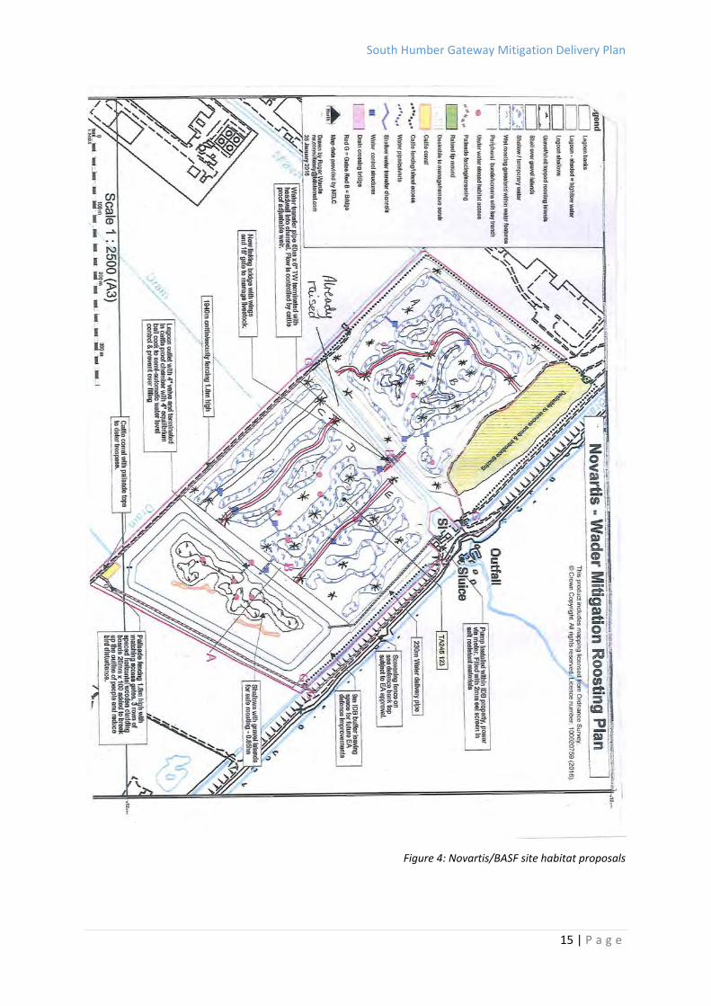
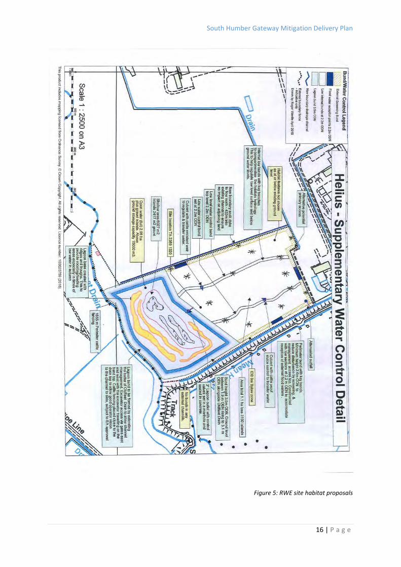
3.10 The proposals for habitat creation on each of the sites are shown below:

South Humber Gateway Mitigation Delivery Plan
14 | P a g e
Figure 3: Inland site habitat proposals
South Humber Gateway Mitigation Delivery Plan
15 | P a g e
Figure 4: Novartis/BASF site habitat proposals
South Humber Gateway Mitigation Delivery Plan
16 | P a g e
Figure 5: RWE site habitat proposals
South Humber Gateway Mitigation Delivery Plan
17 | P a g e
3.11 A Management regime has been devised, which will be implemented over the 20
year period. Following establishment, grazing with a breed of cow able to cope with
wet exposed conditions will be necessary to create the structure suitable for
invertebrate prey populations and wintering waders. Grazing pressure should be in
the region of 100‐250 livestock unit (LSU) days/ha/year, in order to produce a mosaic
of short sward of 5‐7cm in length and tussocks (RSPB 1997).
3.12 In the spring and early summer grazing pressure should be lighter to avoid poaching
and trampling nests and allow herbs to flower and seed. In the late summer and
early autumn grazing pressure could be increased to allow cattle to break down any
large stands of vegetation and open up the sward to create foraging areas for
waders.
3.13 The ground will not be poached, although small areas of bare ground can create
niches for colonisation of plants. Cover of rushes Juncus spp. should be less than 40%
(Natural England 2010). Tussocky swards require grazing to keep them more open
between the tussocks (tussocks ideally at a density of 1 per m2). This provides
suitable habitat for nesting waders. Where rushes are in the sward, management is
needed to maintain the tussocks at the optimum density for Redshank and Lapwing.
A combination of cutting in late summer and grazing can be used to keep density of
tussocks to 1 in 10m2. If tussocks are very dense they can be cut late autumn and
flooded immediately to knock them back.
3.14 Signage and interpretive boards will be used to explain the management of the area
and the importance of lack of disturbance to the area. Stock inspections will be done
from a distance using binoculars, and management tasks will be undertaken in such a
way as to limit the number of disturbance events.
Delivery and Phasing
3.15 Natural England, as the regulatory body ensuring compliance with the Habitats
Regulations, requires ‘certainty’ that the mitigation will meet the requirements of
the Habitats Regulations. As such, it needs to be demonstrated ‘beyond reasonable
doubt’ that the strategic mitigation proposed is achievable “in perpetuity”. Through
discussion with the Ecology Group, “in perpetuity” has been agreed as requiring
appropriate land interests and management agreements for each of the mitigation
sites for a minimum period of 25 years.
3.16 The four identified sites sit within seven separate ownerships. Negotiations have
been progressed with each owner, either on the basis of a freehold purchase or 25
year lease. Purchase values are to be determined at the prevailing market value and
South Humber Gateway Mitigation Delivery Plan
18 | P a g e
subject to a valuation in accordance with the RICS Valuation – Professional Standards
(January 2015) (“The Red Book”).
3.17 The Council will procure appropriate/suitable contractors to undertake the habitat
creation works, and it will also procure a management company to ensure that
appropriate management of the mitigation sites is undertaken in accordance with
the agreed specification over the perpetuity period (25 years). All appointments will
be subject to the Public Procurement Regulations 2015.
3.18 Delivery of each site will be dependent upon the ability to quickly negotiate land
interests and access arrangements with the respective landowners. It is noted,
however, that sites closer to the Estuary have a greater level of importance given
their SPA bird usage. These sites will, therefore, be progressed as a matter of
priority.
3.19 On‐site works will be progressed on an individual basis pending completion of
appropriate land negotiations and the granting of planning permission. It is
recognised that development should not be permitted prior to the Mitigation being
put in place. NELC and Natural England have agreed that, as a matter of course,
mitigation land should always be provided in advance of the employment
development, and that this will be determined on balanced book basis. Each
development proposal will therefore be judged against this approach.
Funding
3.20 Current estimates of cost for land acquisition, habitat creation and management are
currently estimated at between £5.5m and £6.8m, the extent of which is dependent
upon the result of land negotiations and final prices agreed. A breakdown of the
funding requirement is shown below.
Land Acquisition/Lease costs (25 years) £3,296,000 ‐ £4,560,0001
Habitat Creation £1,380,500
Ongoing Management (25 years) £ 894,000
TOTAL £5,570,500 ‐ £6,834,500 Table 1: Strategic Ecological Mitigation Costs
3.21 Funding has been committed from the Council’s SHIIP programme (a £15m funding
programme to deliver key infrastructure projects across the South Humber Bank),
and Greater Lincolnshire LEP Local Growth Fund. A further bid for ESIF funding has
also been allocated and is awaiting final approval. All funds required to deliver the
Ecological Strategic Mitigation are therefore in place.
1 Variations in Acquisition costs based on minimum and maximum values anticipated to be required as part of the negotiation process.
South Humber Gateway Mitigation Delivery Plan
19 | P a g e
3.22 It is intended that the Council will utilise the funds available to it to acquire
appropriate interests in the sites, create wet grassland habitat and ensure a 25‐year
management programme. This investment will therefore enable future
economic/employment development within the South Humber gateway area,
subject to the balancing provisions identified in Paragraph 3.19 above.
3.23 Planning legislation places the responsibility for appropriately mitigating any
negative impact of development on the developer. All development proposals
within the Mitigation Zone will be expected to contribute to the implementation of
the Mitigation Strategy. It is anticipated that contributions will be secured either
through Unilateral Agreements or s106 agreements.
3.24 Analysis of the Employment Land Review indicates that within the proposed
Mitigation Zone, the total developable area equates to 680ha (1,647 acres). This
includes all sites held for some form of future potential operation.
3.25 The contribution sought from developers will be therefore based on the following
equation:
Total Cost/Total Land = £ per ha (£ per acre)
Based on a minimum project cost, this equates to:
£5,570,000/680 = £8,191 per ha (£5,570,000/1,680 = £3,315 per acre)
Based on a maximum project cost, this equates to:
£6,834,500/680 = £10,050 per ha (£6,834,500/1680 = £4,068 per acre)
3.26 On this basis, a contribution of between £8,191 and £10,050 per ha. (£3,315 ‐ £4,068
per acre) could be sought from developers. The total costs of the scheme are
currently provided as a range dependent upon the extent of land price negotiations
and will not be finalised until such time as all negotiations are completed. As an
interim position, the Council intends to set a target contribution figure of £8,650/ha
(£3,500/acre), with this figure being amended accordingly once final values are
ascertained. Details on the final calculations should be provided within appropriate
supplementary documents.
Programme
3.27 The external funding regimes (Greater Lincolnshire LGF and ESIF) associated with this
scheme requires that all funding is committed within the period April 2016 to March
2020. The Council commitment has the ability to be utilised more flexibly, but is
currently anticipated to be fully expended by March 2021. The programme
therefore anticipates delivery of all Strategic Mitigation grassland sites within a five
year programme.
South Humber Gateway Mitigation Delivery Plan
20 | P a g e
Monitoring
3.28 In order to ensure the efficacy of the mitigation sites, regular monitoring will take
place over the perpetuity period to ensure the ecological functioning of the wet
grassland sites. The exact details of the monitoring to be undertaken will be agreed
with the Ecology Group.
South Humber Gateway Mitigation Delivery Plan
21 | P a g e
4.0 Conclusions
4.1 This Mitigation Delivery Plan highlights the importance of the Humber Estuary in ecological
terms, and the conflict that occurs between the protection of the ecological importance of
the Estuary and the promotion of economic development within the South Humber
Gateway.
4.2 The Habitats Regulations require that where an adverse ecological impact will result from
development that is in the overriding public interest, appropriate mitigation can be put in
place to off‐set the adverse impacts.
4.3 A number of surveys relating to the important bird species utilising the Estuary have been
undertaken and have established the extent and importance of the bird populations. Any
development is considered likely to have an adverse impact, and therefore a strategic
approach to mitigation has been devised.
4.4 Within North East Lincolnshire, four sites have been identified which meet the overall
criteria established by the Ecology Group. Detailed proposals for each of these sites has
now been developed, and negotiations have commenced with all of the landowners
concerned.
4.5 In addition, North East Lincolnshire Council has been successful in securing appropriate
funds to ensure mitigation habitats are delivered, and progress has been made to secure
sites for mitigation purposes. All funding needs to be utilised between 2016 and 2020.
Developers within the mitigation area will be expected to make an appropriate contribution
towards the cost of the mitigation scheme.
4.6 This document demonstrates the extent of work and level of commitment made by North
East Lincolnshire Council to delivere the Strategic Mitigation scheme. A funding strategy is
in place, and a programme has been devised which enables the delivery of the scheme over
a period of time. This strategy will protect the long term integrity of the Humber Estuary
SPA by ensuring that any adverse impact of economic development within the South
Humber Gateway is adequately mitigated.

South Humber Gateway Mitigation Delivery Plan
22 | P a g e
APPENDIX 1 Memorandum of Understanding (June 2010)
Memorandum of Understanding for the
Delivery of the South Humber Gateway
Strategic Mitigation
South Humber Gateway Mitigation Group June 2010

Memorandum of Understanding for the
Delivery of the South Humber Gateway
Strategic Mitigation
1. Introduction
1.1 The South Humber Gateway (SHG) is located on the south bank of the Humber estuary. It stretches from the outskirts of Grimsby to the East Halton Skitter. Straddling the boundaries of North Lincolnshire and North East Lincolnshire councils, the SHG is one of the most exciting strategic development locations in the whole of the Yorkshire and Humber region. Covering almost 1,000 hectares – nearly four square miles – of development land it is attracting significant global interest and unprecedented levels of investment. Major investments under way or planned are estimated to be worth almost £2billion. If all goes to plan, upwards of 15,000 new quality jobs will be created over the next 10 years. The SHG already provides 27 per cent of the UK’s refinery capacity and is home to the UK’s busiest ports complex and one of the world’s largest Combined Heat and Power (CHP) plants. Together with its sister Port of Grimsby, Immingham is the UK’s largest port by tonnage.
1.2 At the same time an estimated 175,000 birds visit the estuary every winter, the Humber is one of the top six estuaries for migratory birds in the UK and one of the top ten in Europe. The estuary forms an essential link in a chain of wetland sites creating what is known as the East Atlantic Flyway, stretching from the Arctic Circle to southern Europe and Africa, via the estuaries of North West Europe. The Humber supports internationally important populations of a number of bird species (containing more than one per cent of the Western European non-breeding population) which are attracted by the plentiful food supplies of the salt-marsh and mudflats; often moving inland to roost and feed. In recognition of its value for biodiversity the Humber Estuary has been designated for its national, European and international importance. The Humber Estuary and the populations of wild birds it supports are afforded special protection being designated at national and international levels. The estuary includes several Sites of Special Scientific Interest and is designated as a Special Area of Conservation1, Special Protection Area and Ramsar site. As such, the estuary and its special features are covered by The Conservation of Habitats and Species Regulations 2010 (the “Habitats Regulations”) (SI No. 2010/490).
1.3 Large numbers of SPA/Ramsar birds rely upon terrestrial areas adjacent to the estuary for roosting, loafing and foraging especially at high tide and these areas are therefore of functional importance to the conservation of the SPA/Ramsar bird populations.
1.4 The purpose of this MoU is to demonstrate the commitment of the signatories to cooperative working to establish a mechanism which aims to highlight and resolve the potential conflicts within the South Humber Gateway between the need to realise the national economic benefits of the estuary related opportunities and the need to protect the environmental assets of the area in accordance with the applicable legislative obligations. The main output of the collaboration between key stakeholders is to work to produce, adopt and implement a framework (the Delivery Plan) to address the considerable ecological and economic demands on the SHG.
1 The strategic mitigation is being developed to address potential impact on the SPA and Ramsar fea-tures therefore potential impacts on the SAC will not be addressed by the proposed Delivery Plan
2. Background
2.1 Approximately 80 per cent of the SHG falls within the North Lincolnshire Council boundaries, with the remaining 20 per cent in the North East Lincolnshire Council area. The Killingholme Marshes area is of vital importance to the future development of the SHG, given its proximity to the deep-water channel – the last undeveloped deep-water channel in the UK. Following extensive studies, negotiations are at an advanced stage with landowners and Yorkshire Forward to develop the land. Consequently, there are a number of major planning applications in the system for large-scale industrial and commercial development on both the Killingholme Marshes and East Halton Marshes. Combined, this total area of land represents the major part of the employment allocation within the North Lincolnshire Council boundaries. At the same time, in North East Lincolnshire there are a number of approved planning applications for major bio-energy businesses and also plans for the EuroParc 4 development.
2.2 It is recognised that a large proportion of the planned developments on the SHG could contribute positively to the climate change and sustainability agenda in the following areas: carbon capture and storage, biomass and wind energy, especially that associated with the Round 3 announcement made by the Government. In addition, the flow of trade through the SHG should have less of an environmental impact overland given its central UK location, low-congestion and excellent rail links.
2.3 The Regional Economic Strategy and the Local Development Frameworks of North Lincolnshire Council and North East Lincolnshire Council all recognise the SHG’s strategic economic importance for the Hull and Humber Ports City Region and the wider Yorkshire and Humber Region and the considerable environmental value of the area. Sustainable development of the SHG will bring with it major employment and Gross Value Added (GVA) benefits for the whole of the Hull and Humber Ports City Region, and indeed regionally and beyond.
2.4 All parties to this Memorandum of Understanding are committed, in a spirit of cooperation and transparency, to successfully resolving the challenge of unlocking the unprecedented economic potential of the SHG for the Hull and Humber Ports Region whilst securing the protection and enhancement of a world-class environment. The economic and environment challenges are viewed as inextricably linked.
2.5 If successful, the SHG’s Delivery Plan will provide the necessary framework to fulfil some of the nature conservation requirements of the Humber Estuary SPA and Ramsar site, specifically addressing mitigation needs arising from direct land take from development within the South Humber Bank Employment Allocation2. Although the SHG zone is not in the designated SAC area, any potential impacts on the SAC as a result of development will also need to be addressed. The Delivery Plan will also create clarity and confidence that the impact of direct land take from within the South Humber Gateway can be mitigated both inside and outside the SHG zone. Such an approach will enable the emerging LDF’s to allocate this area for the future estuary related activity and identify a clear framework for potential investors. Of particular value is that the Delivery Plan will work towards a strategic approach across the two unitary councils, in place of an ad hoc site-by-site approach to mitigation.
2.6 The signatories to the Memorandum of Understanding are the key organisations responsible for the development of the Delivery Plan, while those responsible for development are also committed to working cooperatively to safeguard and maintain the integrity of the Designated Site to support the delivery of sustainable development of the area. All the signatories agree to a strategic approach to delivery, believing this avoids a piecemeal approach and creates the necessary clarity and confidence, essential for both conservation bodies and developers/investors. The signatories also recognise that to achieve this requires their continued commitment to explore and examine strategic options to develop and implement the Delivery Plan through a transparent approach. The signatories further recognise that planning positively for wildlife reduces ad hoc loss and compromise, speeds decision-making and reduces the cost and time of submitting and resolving planning applications for estuary-based development.
2 The Employment Allocation in the relevant emerging LDF’s and currently adopted Unitary plans.
2.7 The signatories agree that the Delivery Plan, and the mechanisms identified and agreed to implement it, will be outlined in the North Lincolnshire and North East Lincolnshire Core Strategies with mitigation areas identified in the Allocations Development Plan Document (DPD) and will be subject to assessment under the Habitats Regulations
3. Objectives
3.1 The signatories to this Memorandum of Understanding agree to work cooperatively and transparently to safeguard and maintain the integrity of the Designated Sites while enabling the sustainable development of the area. The signatories agree to the following objectives:
To identify strategic conservation mitigation options through an agreed Delivery Plan, 1. which will form part of the Local Development Frameworks for both North Lincolnshire and North East Lincolnshire Council.
To ensure that the Delivery Plan and the emerging LDFs comply with the Habitat 2. Regulations and are subject to the relevant Regulations 61,62 and 66
To examine the need and nature of Strategic Environmental Assessment for the LDFs 3.
To acknowledge that both the LDF and Delivery Plan for strategic mitigation will be 4. delivered over a period of time and work together to establish these timescales with agreement over what will need to be delivered to meet environmental requirements.
To identify implementation and financial mechanisms for utilising the strategic mitigation 5. that provide a clear process for development to address the issue of direct land take of areas used by SPA and Ramsar birds within the SHG
To ensure the Delivery Plan takes into account the implementation of the approved 6. Humber Estuary Flood Risk Management Strategy and subsequent reviews, recognising that there are intertidal issues
To agree that a Draft Interim Strategy may be helpful in establishing a staged approach 7. as an output of the first stage of work
To agree that mitigation areas identified by the Delivery Plan and associated LDF 8. Allocations documents will be delivered both within the SHG Employment Allocation zone and in close proximity outside this zone, as currently adopted.
To meet the requirements of PPS9 to build in biodiversity to all developments.9.
To examine and agree the evidence base to support the development and 10. implementation of the Delivery Plan, including Identifying the location and extent of existing critical land areas for avifauna – identified through bird survey work.
To agree the area where the Delivery Plan will operate, supported by an agreed 11. evidence base, including optimal management guidelines and basic design principles to ensure that mitigation areas function appropriately
To agree the basis for the ownership and management of mitigation sites, how 12. contributions are worked out and methods of making contributions (S106 agreements/CIL etc) as well as how they will be used and how mitigation sites will be managed and by whom.
To agree requirements for monitoring and review of the Delivery Plan and the mitigation 13. areas.
To share data and to work together to ensure that data are interpreted in a consistent 14. manner by developers and regulators
4. EU Habitats Directive
4.1 In order to ensure that the Delivery Plan complies with the Habitats Regulations, the signatories agree that:
Delivery of mitigation will be based on alone and in combination effects of developing 1. the SHG on the Humber SPA/Ramsar, but will combine to support a strategic approach to economic development and mitigation in the estuary zone.
The Delivery Plan doesn’t necessarily negate the need for an Appropriate Assessment 2. at development control stage for individual developments; however the Delivery Plan should assist the AA process by identifying potential mitigation.
The Delivery Plan will inform the assessment under the Habitats Regulations for the LDFs 3. for North Lincolnshire and North East Lincolnshire councils.
Mitigation sites will be safeguarded in perpetuity with appropriate management regimes4.
5. Mitigation
5.1 In order that strategic mitigation fulfils its requirements under the Habitats Regulations, signatories agree:
That the land will need to be managed specifically for the SPA/Ramsar birds that are 1. impacted by development.
To identify mitigation areas based on evidence of the totality of potential development 2. within the specified zone and possible in-combination effects outside the immediate zone. This will identify the maximum development (worst case scenario) and therefore required mitigation.

To explore and identify methods and options for land acquisition and shared strategic 3. delivery of mitigation.
To consider the options for acquiring mitigation land and how developers may buy into 4. it.
To determine timescales and any phasing to secure habitat 5.
To consider multi-functionality of sites (where still consistent with SPA/Ramsar 6. requirements) including opportunities for accessible green space, acknowledging that if multiple uses are pursued, it may result in additional mitigation land requirements to allow for additional buffers etc
To review progress on a regular basis to ensure continued compliance with the Habitat 7. Regulations
6. Signatories
6.1 The following organisations are signatories to this Memorandum of Understanding
Organisation Officer Title Signature Date
Yorkshire Forward Executive Director Environment 05.05.10
Natural England Regional Director 06.05.10
Environment Agency Area Manager 14.08.10
RSPB Acting Regional Director 05.07.10
Lincolnshire WildlifeTrust
Chief Executive 17.06.10
North EastLincolnshire Council
Leader 12.07.10
North EastLincolnshire Council
Chief Executive 13.07.10
North LincolnshireCouncil
Leader 26.07.10
North LincolnshireCouncil
Chief Executive 02.08.10

South Humber Gateway Mitigation Delivery Plan APPENDIX 2
30 | P a g e
APPENDIX 2 South Humber Gateway Mitigation Approach: Site Options
Assessment
Introduction
This paper provides a summary of the process to date of considering and identifying appropriate
mitigation in the South Humber Gateway, to allow development of the South Humber Gateway
(SHG) and ensure the conservation of the SPA bird populations.
Why Was Action Required?
The work addresses the needs of birds covered by the EU Birds Directive and
included in the Special Protection Area, but does not meet all the requirements of
the Habitat Regulations with regard to protected species and habitats. These will be
addressed through the environmental assessment of individual developments and
the subsequent determination of appropriate measures if necessary through Habitat
Regulations Assessments (HRA).
The overall aim of the work is to provide strategic mitigation which would ensure
ecological functioning of sufficient land to provide adequate habitat for the birds on
land to allow full economic development of the remaining land in the SHG.
Establishing an Agreed Approach
Work on developing a conservation mitigation strategy to assist industrial
development in the South Humber Gateway has been underway for some time. It
has been agreed with key stakeholders, working together as the SHG Ecology Group,
that a strategic approach to providing mitigation for any impacts upon the birds
which use the Estuary would be the most effective way of meeting the requirements
of The Conservation of Habitats and Species Regulations 2010 (SI No. 490) and would
reduce the risk of one development creating problems for others.
Considerable investment from North Lincolnshire Council (NLC), North East
Lincolnshire Council (NELC) and formerly Yorkshire Forward (YF) has gone into the
work required to prepare a strategic approach and significant work has been done to
establish the ecological requirements of the birds, how these can be delivered, how
support for the work can be achieved from industry and how the delivery of the
mitigation strategy can ensure that the planning processes for NLC and NELC can be
seen to comply with the Habitat Regulations.
The work has been aided by the development of a Memorandum of Understanding
between the key parties who have agreed to work together constructively to
develop and deliver the strategy. The MoU was signed in May 2010 and the Group
South Humber Gateway Mitigation Delivery Plan APPENDIX 2
31 | P a g e
worked on specific areas of the work which culminated in the production of an Initial
Delivery Plan in August 2010. This identified the work that needed to be done and
the key players required to achieve; it has been signed up to by both Councils,
Natural England, RSPB, Lincolnshire Wildlife Trust and the Environment Agency.
Establishing a Sound Evidence Base
The work is based upon specific information, understanding and evidence covering:
‐ A through understanding of the legislative framework for the work,
primarily under the Habitat Regulations, 1994 as amended;
‐ Comprehensive waterfowl data for the full extent of the SHG by SPA
birds;
‐ An analysis of bird behaviour, including habitat preferences, roosting
densities , flight lines etc
Clarifying Ecological Principles
The work proceeded outlining a series of general principles that would give a broad
picture of what a final solution would likely look like, these general principles
have subsequently been taken further and a set of Mitigation Principles have
been developed and embodied in the Delivery Plan
GENERAL PRINCIPLES
‐ Continued unmitigated development of the SHG will cause adverse
effects on the integrity of the Humber SPA and Ramsar site
‐ It is highly unlikely that all adverse effects can be mitigated outside the
SHG
‐ Given the size and length of the SHG a single mitigation site would not
represent an acceptable solution
‐ The total area of mitigation will likely be less that the combined area of
land used by birds, provide the mitigation is appropriately located,
designed and managed
‐ There are likely to be areas in the SHG used in such large numbers that
their loss alone or in combination with other development in the area
constitute an adverse effect on the integrity of the Humber SPA and
Ramsar site
‐ The pattern of bird use may indicate areas that subject to the right
mitigation could support higher levels of use and may be suitable for
mitigation
‐ Some areas of the SHG not be used by birds may be affected by factors
such as crop regimes rather than locational factors
MITIGATION PRINCIPLES
South Humber Gateway Mitigation Delivery Plan APPENDIX 2
32 | P a g e
Work was undertaken headed by NE and RSPB to clarify the ecological
understanding necessary to meet the requirements of the birds for roosting and
loafing in the SHG, this culminated in a set of initial mitigation principles:
‐ Area (combined), The mitigation required to enable continued
development of the SHG will need to be sufficient to support the needs of
the birds using the inland areas of the SHG and intertidal areas. Data
collected through the HINCA coordinated surveys suggests that the SHG
supports more than 1% of golden plover, lapwing, curlew, whimbrel and
ruff on c.454ha of the available c.1000ha – the creation of optimal
mitigation would therefore need to mitigate for the loss of the 454ha of
land.
‐ Area (individual), The size of individual mitigation areas will need to take
account of species and numbers of birds to be accommodated, preferred
roosting densities, scanning requirements, disturbance effects and viable
management. Calculations suggest that to create a 20ha core refuge,
allowing for minimal edge effect a minimum 150m sub optimal area of
habitat to absorb edge effects would be 50ha. To achieve confidence in
ecological functioning a minimum of four mitigation areas are required
within the SHG.
‐ Location, Mitigation must be located within appropriate distance of the
intertidal areas, other mitigation areas and ‘the potential development
areas’ used by SPA birds. The sites should allow for distance impacts and
should ideally be contiguous/ near contiguous to the Humber flood banks
and should closely linked
‐ Availability and Suitability, Potential mitigation should be available for
use by target species prior to development commencing
‐ Accessibility, Mitigation must be accessible to the birds they are to
support, and provide clear pathways between other mitigation areas and
areas of the Humber bank
‐ Timing, The mitigation area required to support development must be
ready to support spa birds before that development commences
‐ Habitat Type and Management, This should ensure that the needs of the
target species are met and potential mitigation is maximised.
‐ Efficacy, It is essential that adequate monitoring is undertaken to assess
development and management and use of the mitigation areas
‐ Durability, Arrangements for the ownership and management of the
mitigation measures must be secured in the long term.
REFINEMENT OF THE PRINCIPLES
Care has been taken to consider and refine the mitigation principles, particularly
considering their application in an area of existing landuses. In North East

South Humber Gateway Mitigation Delivery Plan APPENDIX 2
33 | P a g e
Lincolnshire the patchwork of existing industrial uses and the pattern of existing bird
usage raises particular difficulties and considerations.
Whilst work advanced on the refining the individual principles it became clear that
there was not one solution that would deliver the mitigation solution coming from
the principles and that specific site options needed to be considered and evaluated.
This was not a simple process as there was no agreed consensus as to the
significance of weighting or significance of particular factors. It was therefore
through a process of site identification, discussion, and consideration that site
options were refined.
In North East Lincolnshire after a process of early site discussions an initial set of options
were considered (appendix A). These options were set out to explore the significance of
different factors and explore the inter‐relationship between sites. This culminated in June
2011, in an agreed Area of Search (appendix B) within which it was accepted the NEL
mitigation could be provided. Additional work was undertaken to examine the ecological
potential of the identified sites to ensure there were no “show stoppers” to the land
providing appropriate mitigation (Roger Wardle Study). The study addressed the relative
merits of the sites forming the area of search. It concluded all areas presented opportunity
to provide appropriate mitigation.
Having established that the Area of Search could form the basis for identifying an agreed
mitigation approach, the consideration of specific mitigation sites followed. Through a
refinement of boundaries, recognising the significance of important existing bird sites and
patterns of use, interconnectivity of sites, disturbance effects, and proximity to estuary
frontage a preferred approach has been identified (appendix C)
Appendix A
South Humber Gateway Mitigation Delivery Plan APPENDIX 2
34 | P a g e
South Humber Gateway Mitigation Delivery Plan APPENDIX 2
35 | P a g e
South Humber Gateway Mitigation Delivery Plan APPENDIX 2
36 | P a g e
South Humber Gateway Mitigation Delivery Plan APPENDIX 2
37 | P a g e
South Humber Gateway Mitigation Delivery Plan APPENDIX 2
38 | P a g e
South Humber Gateway Mitigation Delivery Plan APPENDIX 2
39 | P a g e
South Humber Gateway Mitigation Delivery Plan APPENDIX 2
40 | P a g e
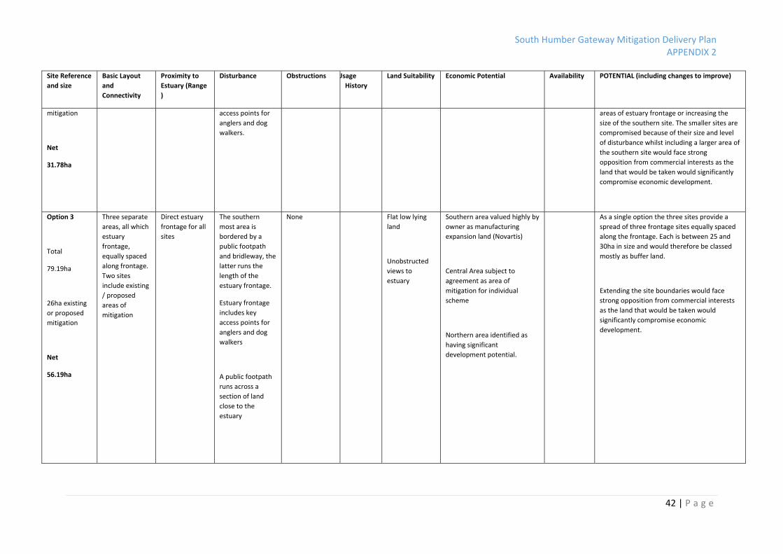
Site Reference
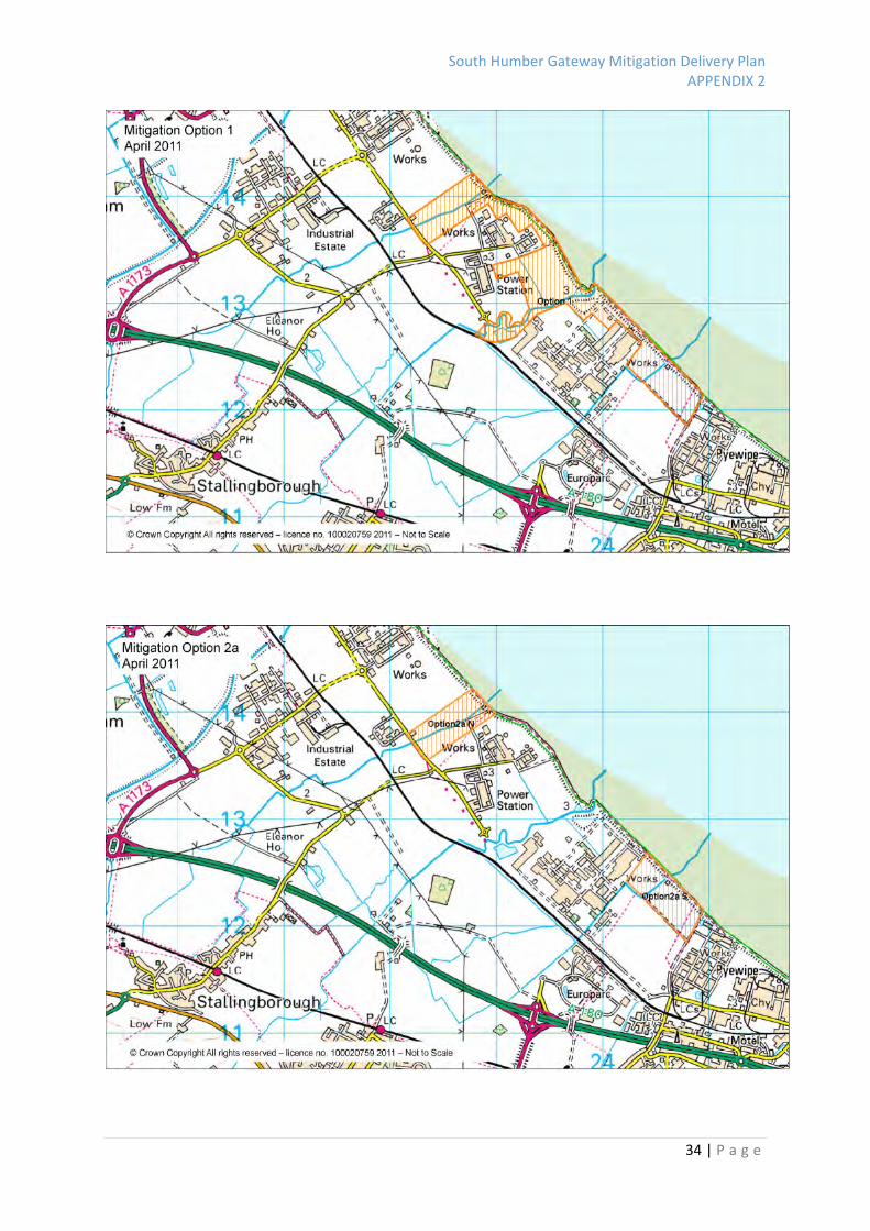
and size
Basic Layout
and
Connectivity
Proximity to
Estuary (Range
)
Disturbance Obstructions Usage
History
Land Suitability Economic Potential Availability POTENTIAL (including changes to improve)
Option 1
Total 110.8ha
23ha existing
or proposed
mitigation
Net 87.8ha
Continuous
narrow ribbon
of sites with
estuary
frontage.
Includes
existing /
proposed areas
of mitigation
Direct estuary
frontage along
long length
The identified land
fits tightly around
existing industrial
complexes. The
southern most
area is bordered
by a public
footpath and
bridleway, the
latter runs the
length of the
estuary frontage.
Estuary frontage
includes key
access points for
anglers and dog
walkers.
A public footpath
runs across a
section of land
close to the
estuary
None Flat low lying
land, very
narrow sites in
some areas.
(Including some
pockets of
raised land)
Unobstructed
views to
estuary
Southern area valued highly by
owner as manufacturing
expansion land (Novartis)
Smaller sites of minimal value
to land owners
Central Area subject to
agreement as area of
mitigation for individual
scheme
Northern area identified as
having significant
development potential.
As a single solution this land provides a
collection of many small sites, including three
main blocks. Each site is to varying degree
compromised by disturbance factors.
The option does not provide an individual site
above 30ha. To extend site boundaries to
provide larger sites would face strong
opposition from commercial interests as the
land that would be taken would significantly
compromise economic development.
The option maximises frontage land which
provides some value and boosts the overall
amount of mitigation land over 80ha but most
would be classed as buffer land due to scale
and disturbance.

South Humber Gateway Mitigation Delivery Plan APPENDIX 2
41 | P a g e
Site Reference
and size
Basic Layout
and
Connectivity
Proximity to
Estuary (Range
)
Disturbance Obstructions Usage
History
Land Suitability Economic Potential Availability POTENTIAL (including changes to improve)
Option 2a
Total
49.63 ha
3ha existing
mitigation
Net
46.63ha
Two separate
areas, both
with estuary
frontage
Direct estuary
frontage for
both sites
The southern
most area is
bordered by a
public footpath
and bridleway, the
latter runs the
length of the
estuary frontage.
Estuary frontage
includes key
access point for
anglers and dog
walkers.
A public footpath
runs across a
section of land
close to the
estuary
None Flat low lying
land
Unobstructed
views to
estuary
Southern area valued highly by
owner as manufacturing
expansion land (Novartis)
Northern area identified as
having significant
development potential.
As a single solution the two sites identified are
compromised by disturbance factors.
Each site is around 25ha
To extend site boundaries to provide larger
sites would face strong opposition from
commercial interests as the land that would
be taken would significantly compromise
economic development.
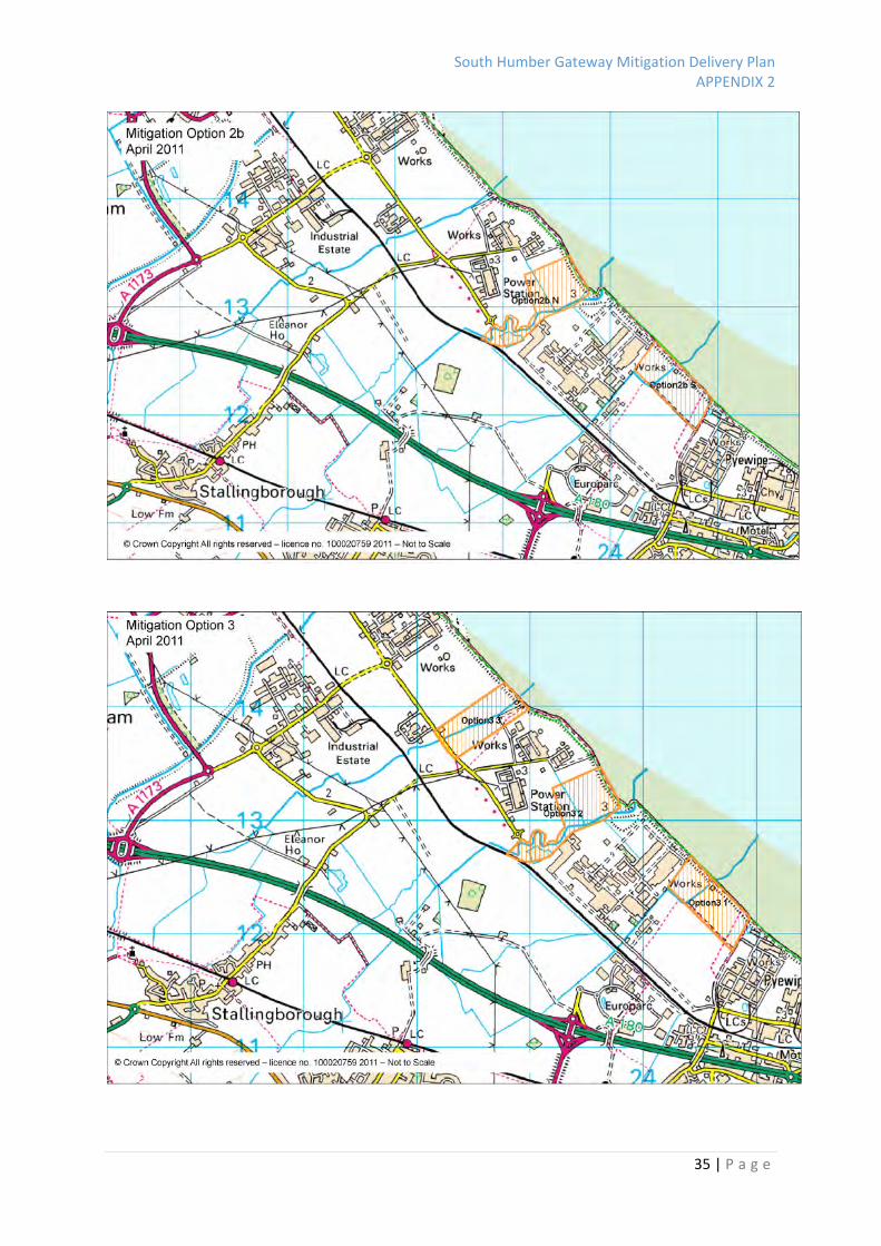
Option 2b
Total
54.78ha
26ha existing
or proposed
Two separate
areas, both
with estuary
frontage one of
which includes
area of
proposed
mitigation
Direct estuary
frontage for
both sites
The southern
most area is
bordered by a
public footpath
and bridleway, the
latter runs the
length of the
estuary frontage.
Estuary frontage
includes key
None Flat low lying
land
Unobstructed
views to
estuary
Southern area valued highly by
owner as manufacturing
expansion land (Novartis)
Central Area subject to
agreement as area of
mitigation for individual
scheme
As a single solution the two sites identified are
compromised by disturbance.
The inclusion of additional frontage land
would provide some value and would boost
the overall amount of mitigation land but
most would be classed as buffer land due to
scale and disturbance To extend site
boundaries would involve including smaller
South Humber Gateway Mitigation Delivery Plan APPENDIX 2
42 | P a g e
Site Reference
and size
Basic Layout
and
Connectivity
Proximity to
Estuary (Range
)
Disturbance Obstructions Usage
History
Land Suitability Economic Potential Availability POTENTIAL (including changes to improve)
mitigation
Net
31.78ha
access points for
anglers and dog
walkers.
areas of estuary frontage or increasing the
size of the southern site. The smaller sites are
compromised because of their size and level
of disturbance whilst including a larger area of
the southern site would face strong
opposition from commercial interests as the
land that would be taken would significantly
compromise economic development.
Option 3
Total
79.19ha
26ha existing
or proposed
mitigation
Net
56.19ha
Three separate
areas, all which
estuary
frontage,
equally spaced
along frontage.
Two sites
include existing
/ proposed
areas of
mitigation
Direct estuary
frontage for all
sites
The southern
most area is
bordered by a
public footpath
and bridleway, the
latter runs the
length of the
estuary frontage.
Estuary frontage
includes key
access points for
anglers and dog
walkers
A public footpath
runs across a
section of land
close to the
estuary
None Flat low lying
land
Unobstructed
views to
estuary
Southern area valued highly by
owner as manufacturing
expansion land (Novartis)
Central Area subject to
agreement as area of
mitigation for individual
scheme
Northern area identified as
having significant
development potential.
As a single option the three sites provide a
spread of three frontage sites equally spaced
along the frontage. Each is between 25 and
30ha in size and would therefore be classed
mostly as buffer land.
Extending the site boundaries would face
strong opposition from commercial interests
as the land that would be taken would
significantly compromise economic
development.
South Humber Gateway Mitigation Delivery Plan APPENDIX 2
43 | P a g e
Site Reference
and size
Basic Layout
and
Connectivity
Proximity to
Estuary (Range
)
Disturbance Obstructions Usage
History
Land Suitability Economic Potential Availability POTENTIAL (including changes to improve)
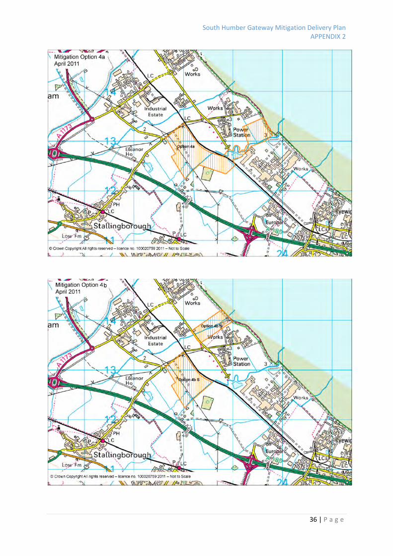
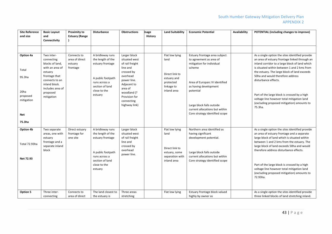
Option 4a
Total
95.3ha
20ha
proposed
mitigation
Net
75.3ha
Two inter‐
connecting
blocks of land,
with an area of
estuary
frontage that
connects to an
inland block.
Includes area of
proposed
mitigation
Connects to
area of direct
estuary
frontage
A bridleway runs
the length of the
estuary frontage
A public footpath
runs across a
section of land
close to the
estuary
Larger block
situated west
of rail freight
line and
crossed by
overhead
power line.
Adjacent to
area of
woodland (?
Provision for
connecting
highway link)
Flat low lying
land
Direct link to
estuary and
protected
linkage to
inland area
Estuary frontage area subject
to agreement as area of
mitigation for individual
scheme
Area of Europarc IV identified
as having development
potential
Large block falls outside
current allocations but within
Core strategy identified scope
As a single option the sites identified provide
an area of estuary frontage linked through an
inland corridor to a large block of land which
is situated within between 1 and 2 kms from
the estuary. The large block of land exceeds
50ha and would therefore address
disturbance effects.
Part of the large block is crossed by a high
voltage line however total mitigation land
(excluding proposed mitigation) amounts to
75.3ha.
Option 4b
Total 72.93ha
Net 72.93
Two separate
areas, one with
estuary
frontage and a
separate inland
block
Direct estuary
frontage for
one site
A bridleway runs
the length of the
estuary frontage
A public footpath
runs across a
section of land
close to the
estuary
Larger block
situated west
of rail freight
line and
crossed by
overhead
power line.
Flat low lying
land
Direct link to
estuary, some
separation with
inland area
Northern area identified as
having significant
development potential.
Large block falls outside
current allocations but within
Core strategy identified scope
As a single option the sites identified provide
an area of estuary frontage and a separate
large block of land which is situated within
between 1 and 2 kms from the estuary. The
large block of land exceeds 50ha and would
therefore address disturbance effects.
Part of the large block is crossed by a high
voltage line however total mitigation land
(excluding proposed mitigation) amounts to
72.93ha.
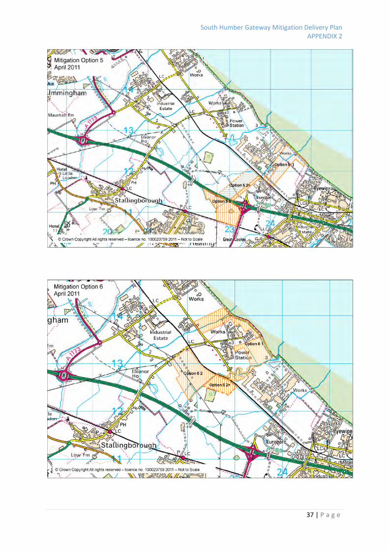
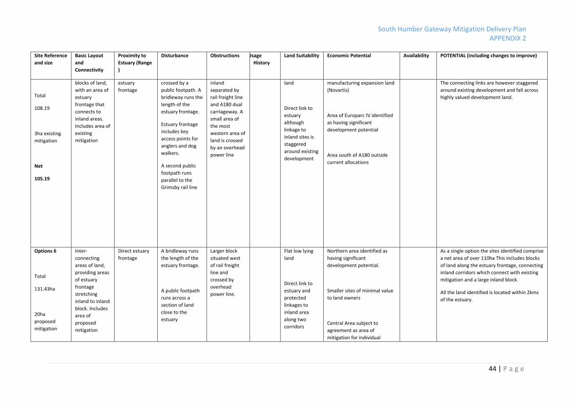
Option 5 Three inter‐
connecting
Connects to
area of direct
The land closest to
the estuary is
Three areas
stretching
Flat low lying Estuary frontage block valued
highly by owner as
As a single option the sites identified provide
three linked blocks of land stretching inland.
South Humber Gateway Mitigation Delivery Plan APPENDIX 2
44 | P a g e
Site Reference
and size
Basic Layout
and
Connectivity
Proximity to
Estuary (Range
)
Disturbance Obstructions Usage
History
Land Suitability Economic Potential Availability POTENTIAL (including changes to improve)
Total
108.19
3ha existing
mitigation
Net
105.19
blocks of land,
with an area of
estuary
frontage that
connects to
inland areas.
Includes area of
existing
mitigation
estuary
frontage
crossed by a
public footpath. A
bridleway runs the
length of the
estuary frontage.
Estuary frontage
includes key
access points for
anglers and dog
walkers.
A second public
footpath runs
parallel to the
Grimsby rail line
inland
separated by
rail freight line
and A180 dual
carriageway. A
small area of
the most
western area of
land is crossed
by an overhead
power line
land
Direct link to
estuary
although
linkage to
inland sites is
staggered
around existing
development
manufacturing expansion land
(Novartis)
Area of Europarc IV identified
as having significant
development potential
Area south of A180 outside
current allocations
The connecting links are however staggered
around existing development and fall across
highly valued development land.
Options 6
Total
131.43ha
20ha
proposed
mitigation
Inter‐
connecting
areas of land,
providing areas
of estuary
frontage
stretching
inland to inland
block. Includes
area of
proposed
mitigation
Direct estuary
frontage
A bridleway runs
the length of the
estuary frontage.
A public footpath
runs across a
section of land
close to the
estuary
Larger block
situated west
of rail freight
line and
crossed by
overhead
power line.
Flat low lying
land
Direct link to
estuary and
protected
linkages to
inland area
along two
corridors
Northern area identified as
having significant
development potential.
Smaller sites of minimal value
to land owners
Central Area subject to
agreement as area of
mitigation for individual
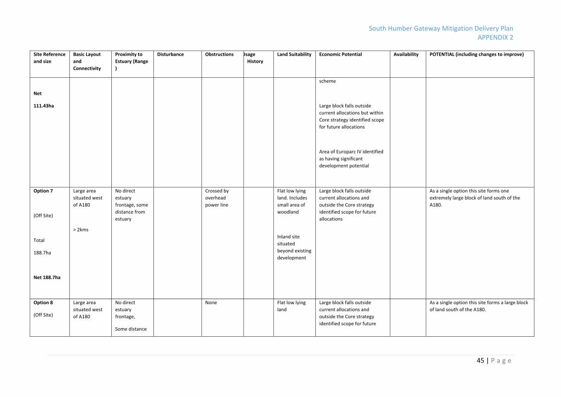
As a single option the sites identified comprise
a net area of over 110ha This includes blocks
of land along the estuary frontage, connecting
inland corridors which connect with existing
mitigation and a large inland block.
All the land identified is located within 2kms
of the estuary.
South Humber Gateway Mitigation Delivery Plan APPENDIX 2
45 | P a g e
Site Reference
and size
Basic Layout
and
Connectivity
Proximity to
Estuary (Range
)
Disturbance Obstructions Usage
History
Land Suitability Economic Potential Availability POTENTIAL (including changes to improve)
Net
111.43ha
scheme
Large block falls outside
current allocations but within
Core strategy identified scope
for future allocations
Area of Europarc IV identified
as having significant
development potential
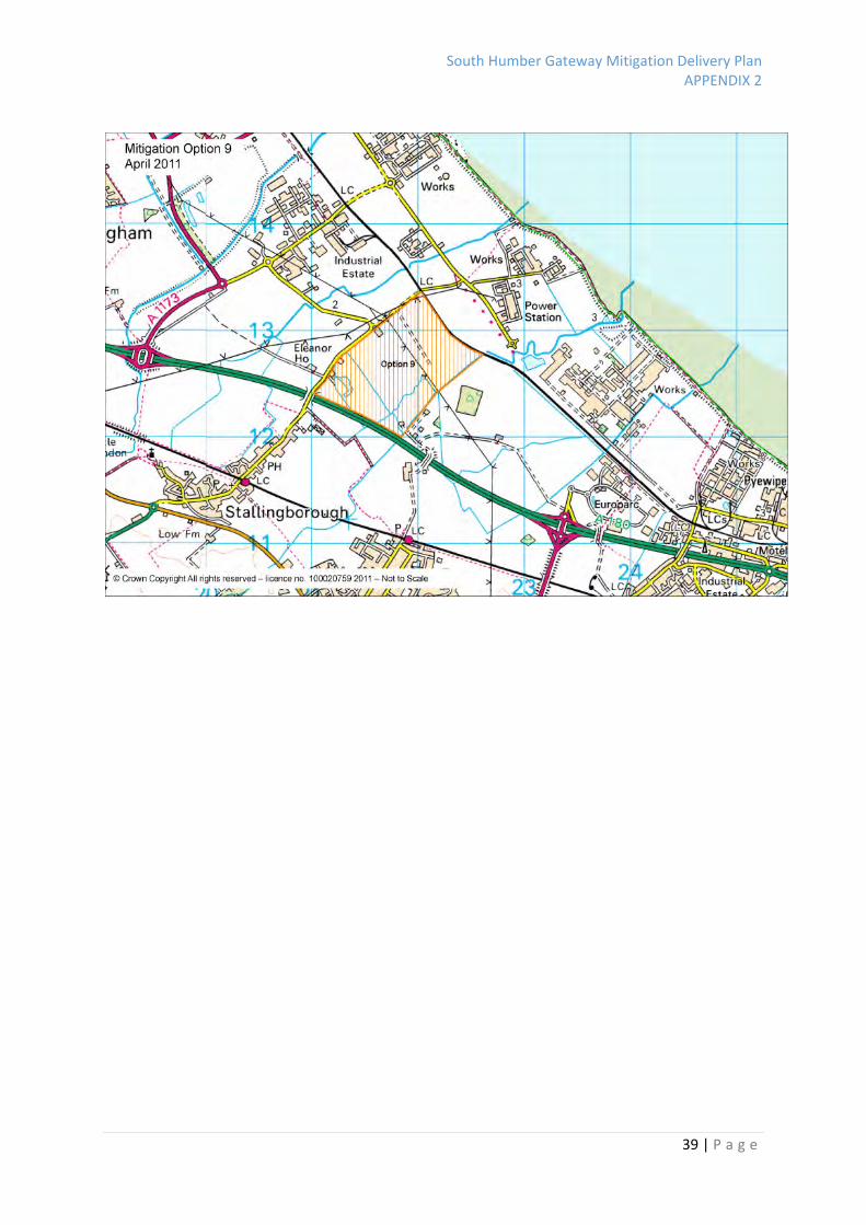
Option 7
(Off Site)
Total
188.7ha
Net 188.7ha
Large area
situated west
of A180
> 2kms
No direct
estuary
frontage, some
distance from
estuary
Crossed by
overhead
power line
Flat low lying
land. Includes
small area of
woodland
Inland site
situated
beyond existing
development
Large block falls outside
current allocations and
outside the Core strategy
identified scope for future
allocations
As a single option this site forms one
extremely large block of land south of the
A180.
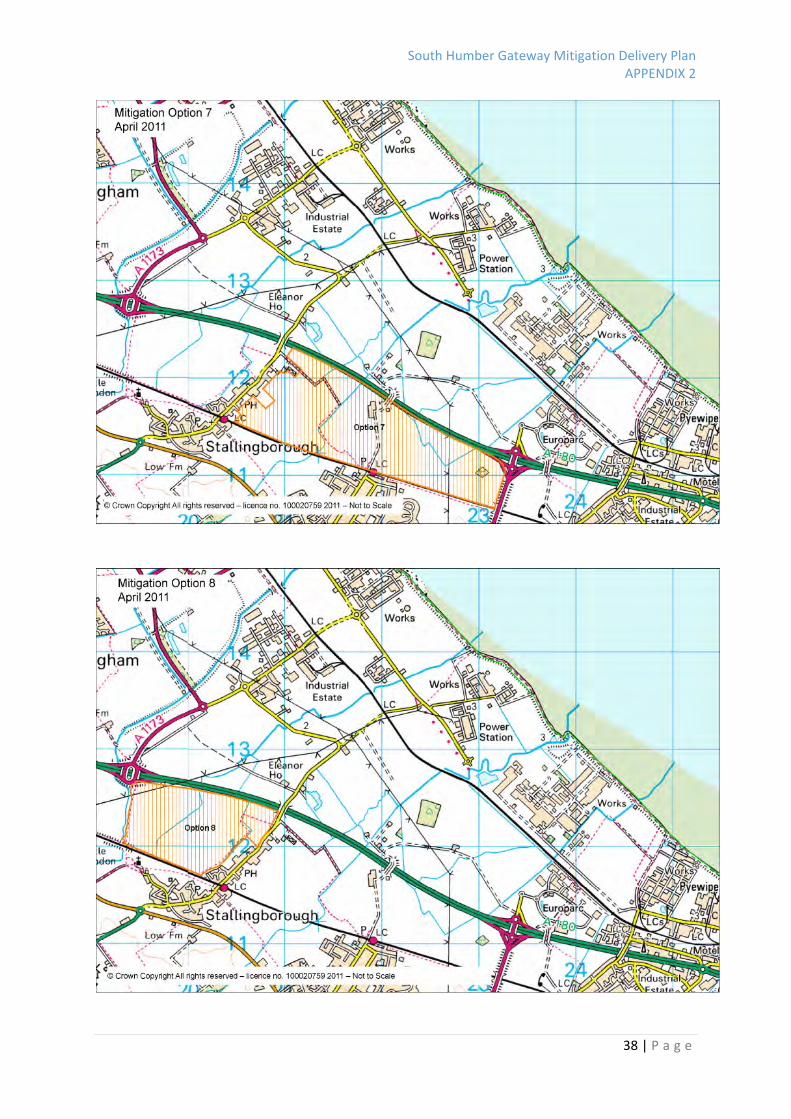
Option 8
(Off Site)
Large area
situated west
of A180
No direct
estuary
frontage,
Some distance
None Flat low lying
land
Large block falls outside
current allocations and
outside the Core strategy
identified scope for future
As a single option this site forms a large block
of land south of the A180.
South Humber Gateway Mitigation Delivery Plan APPENDIX 2
46 | P a g e
Site Reference
and size
Basic Layout
and
Connectivity
Proximity to
Estuary (Range
)
Disturbance Obstructions Usage
History
Land Suitability Economic Potential Availability POTENTIAL (including changes to improve)
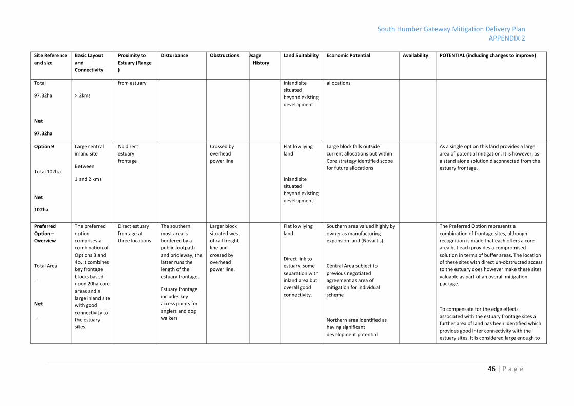
Total
97.32ha
Net
97.32ha
> 2kms
from estuary Inland site
situated
beyond existing
development
allocations
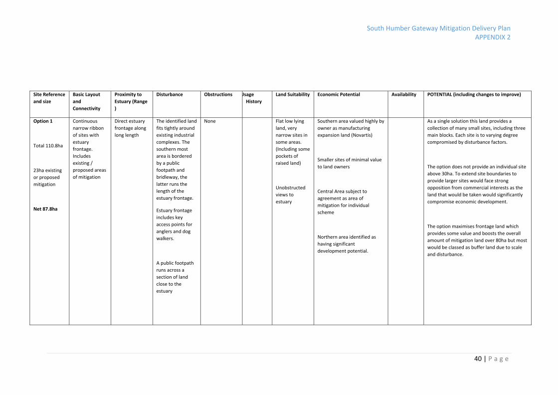
Option 9
Total 102ha
Net
102ha
Large central
inland site
Between
1 and 2 kms
No direct
estuary
frontage
Crossed by
overhead
power line
Flat low lying
land
Inland site
situated
beyond existing
development
Large block falls outside
current allocations but within
Core strategy identified scope
for future allocations
As a single option this land provides a large
area of potential mitigation. It is however, as
a stand alone solution disconnected from the
estuary frontage.
Preferred
Option –
Overview
Total Area
…
Net
…
The preferred
option
comprises a
combination of
Options 3 and
4b. It combines
key frontage
blocks based
upon 20ha core
areas and a
large inland site
with good
connectivity to
the estuary
sites.
Direct estuary
frontage at
three locations
The southern
most area is
bordered by a
public footpath
and bridleway, the
latter runs the
length of the
estuary frontage.
Estuary frontage
includes key
access points for
anglers and dog
walkers
Larger block
situated west
of rail freight
line and
crossed by
overhead
power line.
Flat low lying
land
Direct link to
estuary, some
separation with
inland area but
overall good
connectivity.
Southern area valued highly by
owner as manufacturing
expansion land (Novartis)
Central Area subject to
previous negotiated
agreement as area of
mitigation for individual
scheme
Northern area identified as
having significant
development potential
The Preferred Option represents a
combination of frontage sites, although
recognition is made that each offers a core
area but each provides a compromised
solution in terms of buffer areas. The location
of these sites with direct un‐obstructed access
to the estuary does however make these sites
valuable as part of an overall mitigation
package.
To compensate for the edge effects
associated with the estuary frontage sites a
further area of land has been identified which
provides good inter connectivity with the
estuary sites. It is considered large enough to

South Humber Gateway Mitigation Delivery Plan APPENDIX 2
47 | P a g e
Site Reference
and size
Basic Layout
and
Connectivity
Proximity to
Estuary (Range
)
Disturbance Obstructions Usage
History
Land Suitability Economic Potential Availability POTENTIAL (including changes to improve)
A public footpath
runs across a
section of land
close to the
estuary
The large inland block falls
outside current allocations but
within Core strategy identified
scope
address edge effects and is of a size that is
likely to be attractive to target waterbirds.

South Humber Gateway Mitigation Delivery Plan APPENDIX 2
48 | P a g e
Summary of Options Responses
Natural England
Option 1 made up of smaller sites, whilst offering site frontage unlikely to contribute to SPA/Ramsar mitigation
Most promising areas are next to Novartis and Millenium linking to inland area Option 9
Importance of connectivity between inland area and estuary frontage
? Need to clarify exactly what ecological function estuary land would deliver
Re‐routing of footpaths should be explored
Options 7,8,9 on their own not acceptable, to far from estuary to achieve meaningful connectivity
Not convinced proposed mitigation at NPower would not be required
Lincolnshire Wildlife Trust
Option 1 whilst having advantages in linking estuary frontages the small strips are not suitable for SPA/Ramsar mitigation, might be appropriate if Novartis block extended (LWT would bow to expertise from NE/RSPB
Prefer Option 1 to 2a as it excludes some land in central area outside the NPower mitigation land
2b not acceptable, south are not large enough and northern area existing mitigation
Option 3 as per comments under options 1 and 2
Option 4a, linkage to estuary favoured but sacrifices all current undeveloped estuary frontage, not considered acceptable
Option 4b, Whilst this option does provide additional mitigation with estuary frontage there will soon be development between it and the inland block, not considered acceptable
Option 5, this option has some benefits, particularly the enlargement of the Novartis site but crossing the motorway takes it too far from the estuary, not considered acceptable on its own
Option 6, as for option 4b although the addition of additional land makes it more useful
Option 7,8, crossing the motorway with no estuary links makes these options unacceptable
Option 9, Whilst this provides a significant sized block it has the same disadvantages as option 4a, not considered acceptable
Preference would be for Option 1 with extensions north and south combined with Option 4a
RSPB
Advice remains most appropriate strategic mitigation solution for SHB would be in the order of 4 c50ha blocks along the estuary frontage plus an area outside, but close to SHB
Most of the options have some merit which is worth exploring further with the exception of those options which are exclusively inland sites
Not possible to achieve the appropriate ecological function without mitigation which is in part directly adjacent to the estuary
No single option presents a solution which is robust enough to provide the necessary strategic mitigation, although most options have some merit
The focus should be on areas identified in larger blocks along the estuary frontage, (Millenium, NPower and Novartis, at least 2‐3 good sized blocks) with addition of larger block further inland, close and connected to the estuary
If current data does not identify bird use, it is essential to understand and have confidence that sites would provide appropriate mitigation
Sensible to build on existing high value and secured waterbird mitigation
Ecology Group Minutes 9th May 2011
General feeling, Land south of the A180 not ideal due to distance form estuary
General Agreement, Linking estuary frontage to larger site slightly further inland would be effective, if well managed along with already committed NPower land they should meet the required ecological functions to provide sufficient mitigation for NEL area

South Humber Gateway Mitigation Delivery Plan APPENDIX 2
49 | P a g e
Appendix B
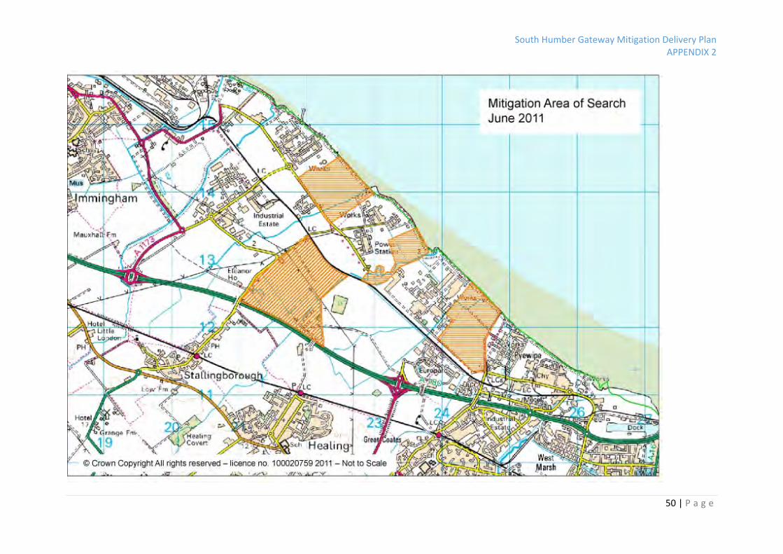
South Humber Gateway Mitigation Delivery Plan APPENDIX 2
50 | P a g e

South Humber Gateway Mitigation Delivery Plan APPENDIX 2
51 | P a g e
Appendix C
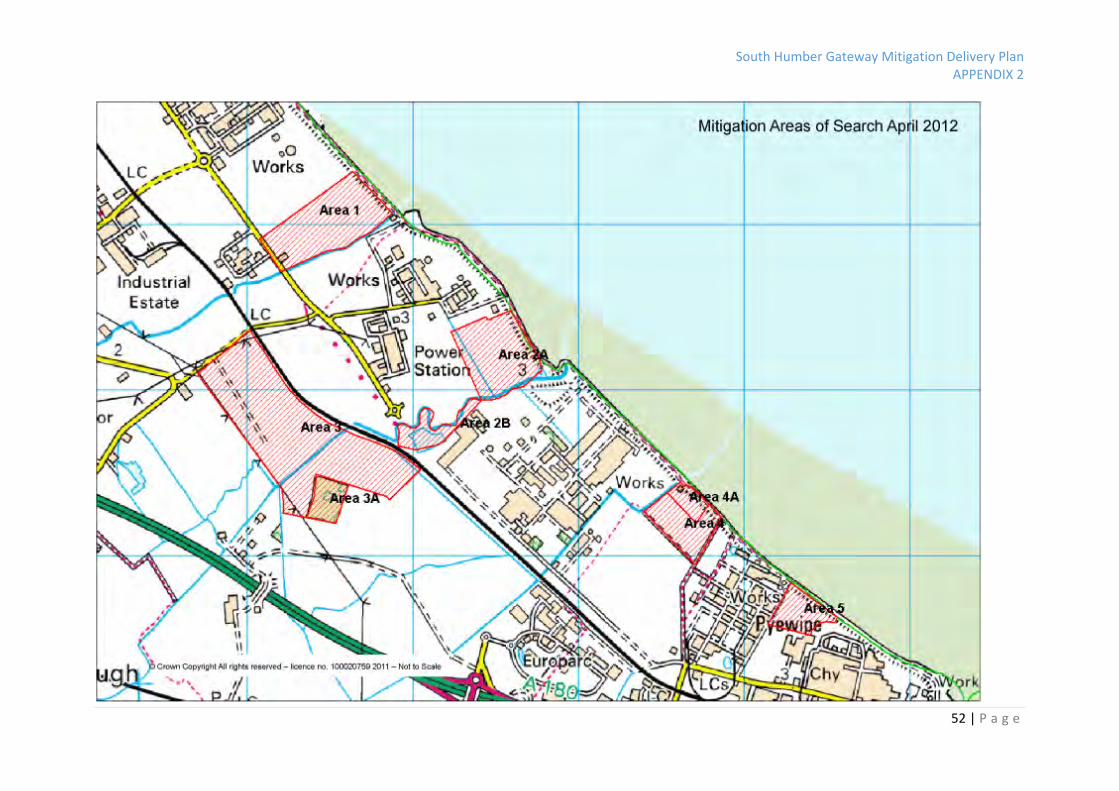
South Humber Gateway Mitigation Delivery Plan APPENDIX 2
52 | P a g e
South Humber Gateway Mitigation Delivery Plan APPENDIX 2
53 | P a g e
North East Lincolnshire Strategic Mitigation for SHG Preferred Approach Size The mitigation identified on the Plan equates to a total gross area of 151.16ha. This includes 21.36ha of land which is either existing mitigation land (area 4A or land where an agreed mitigation scheme has been negotiated (area 2A). Whilst this represents land secured on a site by site basis it has been included in the gross area as the land has added ecological value as part of the strategic mitigation scheme*. Sites “B and 3A are included in the total package as they provide important buffers or flight corridors but are not included in the calculation of net mitigation provided. The overall net mitigation proposed exceeds 100ha** Overall Net Mitigation – 119.62ha *agreement of value of existing mitigation, ecology group meeting minutes…. **calculation of mitigation to be secured acknowledges that total area of mitigation is less than total area of combined areas of fields currently used Basic Layout and Connectivity The mitigation identified recognises that the adverse effects of developing land within the South Humber Gateway (SHG) can not be mitigated without providing mitigation land within the SHG. Given the size and distribution of existing development within the SHG a single mitigation site would not be appropriate*. It recognises that within the SHG some areas are used by birds in such high numbers that their loss alone or in combination with other development would lead to adverse effect**. The mitigation proposed also recognises that sites can in appropriate cases support higher levels of bird use subject to appropriate management. Conversely, it also recognises that some sites will not be used by birds because of specific site considerations. (There is therefore a need to examine individual site characteristics). Bird data illustrates that the birds favour different sites at different times and that no rigid selection criteria hold true for all sites. What can be said is that some criteria appear more significant than others. The mitigation identified has been developed from the initial “area of search” identified by the ecology group***. *RSPB principles 2008 **HINCA Study Data ***Ecology group meeting minutes… Proximity to Estuary The mitigation identified recognises proximity to the estuary, as a fundamental criterion. The bird data illustrates that bird numbers are connected on a number of sites, each of these sites vary with respect to size, proximity to existing industry, and disturbance however all provide direct access to the estuary and adjacent mudflats. Disturbance The preferred roosting and scanning requirements for SPA birds would suggest that sites need to be large enough to support birds roosting and feeding characteristics, incorporating a 200m buffer. In North East Lincolnshire there is local evidence with regard to the localised impacts of disturbance. This would point to the fact that for certain species the proximity to industrial complexes is not a key roosting criterion. In particular where proximity to estuary frontage is maximised. Area 5 (6.78ha) whilst very small and immediately adjacent to existing industry is the most heavily utilised site in North East Lincolnshire recording high numbers of roosting birds.