South Coast Missing Linkages - SC Wildlands Partners: We would like to recognize our partners on the...
67
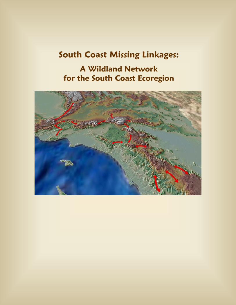
South Coast Missing Linkages: A Wildland Network for the South Coast Ecoregion
Transcript of South Coast Missing Linkages - SC Wildlands Partners: We would like to recognize our partners on the...
South Coast Missing Linkages:
A Wildland Network for the South Coast Ecoregion
Produced by South Coast Wildlands: Our Mission is to protect and restore systems of connected wildlands that support native wildlife and the ecosystems upon which they rely.
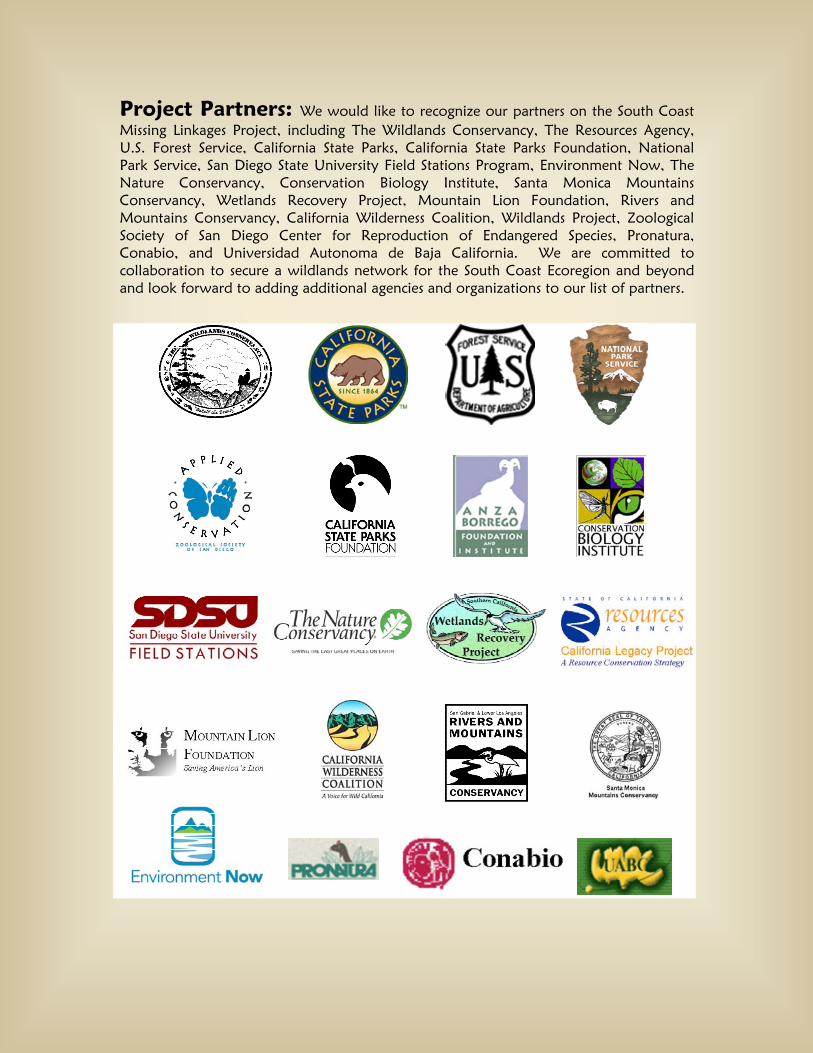
Project Partners: We would like to recognize our partners on the South Coast Missing Linkages Project, including The Wildlands Conservancy, The Resources Agency, U.S. Forest Service, California State Parks, California State Parks Foundation, National Park Service, San Diego State University Field Stations Program, Environment Now, The Nature Conservancy, Conservation Biology Institute, Santa Monica Mountains Conservancy, Wetlands Recovery Project, Mountain Lion Foundation, Rivers and Mountains Conservancy, California Wilderness Coalition, Wildlands Project, Zoological Society of San Diego Center for Reproduction of Endangered Species, Pronatura, Conabio, and Universidad Autonoma de Baja California. We are committed to collaboration to secure a wildlands network for the South Coast Ecoregion and beyond and look forward to adding additional agencies and organizations to our list of partners.
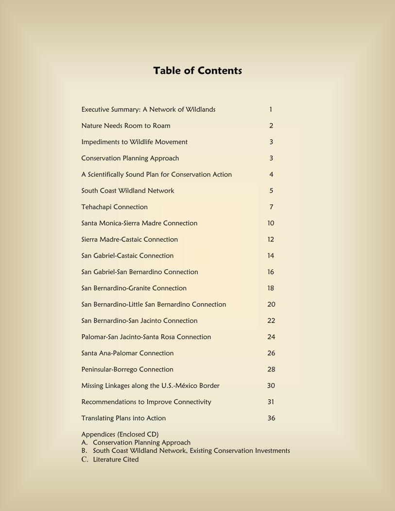
Table of Contents
Executive Summary: A Network of Wildlands 1
Nature Needs Room to Roam 2
Impediments to Wildlife Movement 3
Conservation Planning Approach 3
A Scientifically Sound Plan for Conservation Action 4
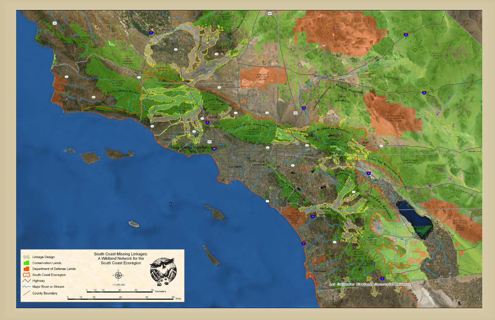
South Coast Wildland Network 5
Tehachapi Connection 7
Santa Monica-Sierra Madre Connection 10
Sierra Madre-Castaic Connection 12
San Gabriel-Castaic Connection 14
San Gabriel-San Bernardino Connection 16
San Bernardino-Granite Connection 18
San Bernardino-Little San Bernardino Connection 20
San Bernardino-San Jacinto Connection 22
Palomar-San Jacinto-Santa Rosa Connection 24
Santa Ana-Palomar Connection 26
Peninsular-Borrego Connection 28
Missing Linkages along the U.S.-México Border 30
Recommendations to Improve Connectivity 31
Translating Plans into Action 36
Appendices (Enclosed CD) A. Conservation Planning Approach B. South Coast Wildland Network, Existing Conservation Investments C. Literature Cited

Executive Summary: A Network of Wildlands
Only a century ago, southern California was one vast wildland supporting a dazzling array of habitats and a veritable treasure trove of life. Creatures great and small, mobile and stationary – many found no where else on earth - thrived in these habitats. Grizzly bears dominated the landscape and mountain lions roamed from the mountains to the sea.
Much of this vast wildland has been lost to housing developments, freeways, and strip malls, with drastic impacts on the abundant plant and animal communities that flourished here. Yet, much of the unique vegetation and wildlife that dominated this pre-development landscape can still be found, and what remains can be maintained, despite the changes we’ve made and continue making to the landscape. Habitat loss and fragmentation are the leading threats to biodiversity worldwide, and nowhere is the risk more severe than in southern California. Countering these threats requires protecting connections between our existing open space areas to form a regional wildland network. Such an interconnected set of reserves would allow natural ecological processes—such as migration and range shifts with climate change--to continue operating as they have for millennia. The South Coast Missing Linkages project has developed a comprehensive plan for such a regional network that would maintain and restore critical habitat linkages between existing reserves. These linkages form the backbone of a conservation strategy for southern California where the whole would be greater than the sum of the parts. This strategy represents the best hope for maintaining what remains of southern California’s wildlife legacy, while ensuring quality of life for our citizens via clean air, clean water, and recreational opportunities. South Coast Missing Linkages is a highly collaborative inter-agency effort to identify and conserve the highest-priority linkages in the South Coast Ecoregion. Partners include South Coast Wildlands, National Park Service, U.S. Forest Service, California State Parks, The Wildlands Conservancy, The Resources Agency, California State Parks Foundation, The Nature Conservancy, Santa Monica Mountains Conservancy, Resources Legacy Foundation, Conservation Biology Institute, San Diego State University Field Stations Program, Environment Now, Mountain Lion Foundation, and the Zoological Society of San Diego’s Conservation and Research for Endangered Species, among others. Cross-border alliances have also been formed with Pronatura, Universidad Autonoma de Baja California, Terra Peninsular, and Conabio, in recognition of our shared vision for ecological connectivity across the border into Baja.
The South Coast Ecoregion encompasses roughly 8% of California and extends 190 miles into Baja.
1
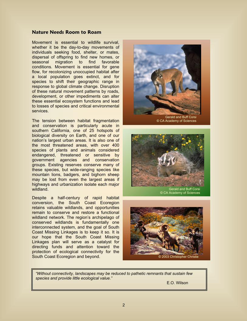
Nature Needs Room to Roam Movement is essential to wildlife survival, whether it be the day-to-day movements of individuals seeking food, shelter, or mates, dispersal of offspring to find new homes, or seasonal migration to find favorable conditions. Movement is essential for gene flow, for recolonizing unoccupied habitat after a local population goes extinct, and for species to shift their geographic range in response to global climate change. Disruption of these natural movement patterns by roads, development, or other impediments can alter these essential ecosystem functions and lead to losses of species and critical environmental services. The tension between habitat fragmentation and conservation is particularly acute in southern California, one of 25 hotspots of biological diversity on Earth, and one of our nation’s largest urban areas. It is also one of the most threatened areas, with over 400 species of plants and animals considered endangered, threatened or sensitive by government agencies and conservation groups. Existing reserves conserve many of these species, but wide-ranging species like mountain lions, badgers, and bighorn sheep may be lost from even the largest areas if highways and urbanization isolate each major wildland.
Despite a half-century of rapid habitat conversion, the South Coast Ecoregion retains valuable wildlands, and opportunities remain to conserve and restore a functional wildland network. The region’s archipelago of conserved wildlands is fundamentally one interconnected system, and the goal of South Coast Missing Linkages is to keep it so. It is our hope that the South Coast Missing Linkages plan will serve as a catalyst for directing funds and attention toward the protection of ecological connectivity for the South Coast Ecoregion and beyond.
“Without connectivity, landscapes may be reduced to pathetic remnants that sustain few species and provide little ecological value.”
E.O. Wilson
© 2003 Christopher Christie
Gerald and Buff Corsi © CA Academy of Sciences
Gerald and Buff Corsi © CA Academy of Sciences
2
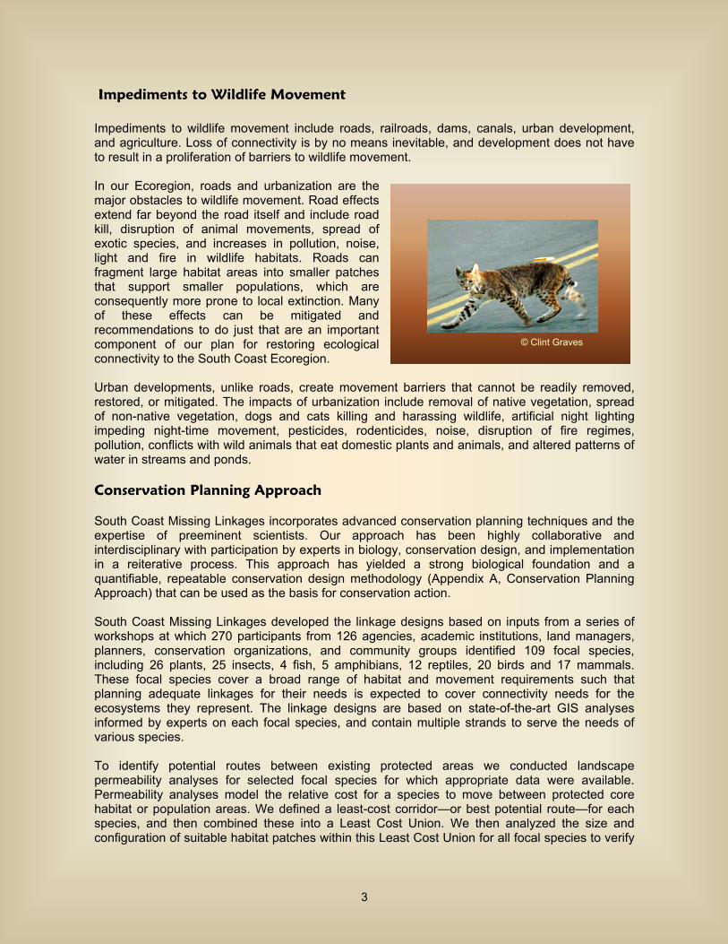
Impediments to Wildlife Movement Impediments to wildlife movement include roads, railroads, dams, canals, urban development, and agriculture. Loss of connectivity is by no means inevitable, and development does not have to result in a proliferation of barriers to wildlife movement. In our Ecoregion, roads and urbanization are the major obstacles to wildlife movement. Road effects extend far beyond the road itself and include road kill, disruption of animal movements, spread of exotic species, and increases in pollution, noise, light and fire in wildlife habitats. Roads can fragment large habitat areas into smaller patches that support smaller populations, which are consequently more prone to local extinction. Many of these effects can be mitigated and recommendations to do just that are an important component of our plan for restoring ecological connectivity to the South Coast Ecoregion. Urban developments, unlike roads, create movement barriers that cannot be readily removed, restored, or mitigated. The impacts of urbanization include removal of native vegetation, spread of non-native vegetation, dogs and cats killing and harassing wildlife, artificial night lighting impeding night-time movement, pesticides, rodenticides, noise, disruption of fire regimes, pollution, conflicts with wild animals that eat domestic plants and animals, and altered patterns of water in streams and ponds. Conservation Planning Approach South Coast Missing Linkages incorporates advanced conservation planning techniques and the expertise of preeminent scientists. Our approach has been highly collaborative and interdisciplinary with participation by experts in biology, conservation design, and implementation in a reiterative process. This approach has yielded a strong biological foundation and a quantifiable, repeatable conservation design methodology (Appendix A, Conservation Planning Approach) that can be used as the basis for conservation action. South Coast Missing Linkages developed the linkage designs based on inputs from a series of workshops at which 270 participants from 126 agencies, academic institutions, land managers, planners, conservation organizations, and community groups identified 109 focal species, including 26 plants, 25 insects, 4 fish, 5 amphibians, 12 reptiles, 20 birds and 17 mammals. These focal species cover a broad range of habitat and movement requirements such that planning adequate linkages for their needs is expected to cover connectivity needs for the ecosystems they represent. The linkage designs are based on state-of-the-art GIS analyses informed by experts on each focal species, and contain multiple strands to serve the needs of various species. To identify potential routes between existing protected areas we conducted landscape permeability analyses for selected focal species for which appropriate data were available. Permeability analyses model the relative cost for a species to move between protected core habitat or population areas. We defined a least-cost corridor—or best potential route—for each species, and then combined these into a Least Cost Union. We then analyzed the size and configuration of suitable habitat patches within this Least Cost Union for all focal species to verify
© Clint Graves
3
that the final Linkage Design would suit the live-in or move-through habitat needs of all. Where the Least Cost Union omitted areas essential to the needs of a particular species, we expanded the Linkage Design to accommodate that species’ particular requirements, and ensure that no species was left behind. We also visited priority areas in the field to identify and evaluate barriers to wildlife movement. We also suggest restoration strategies to mitigate those barriers, with special emphasis on opportunities to reduce the adverse effects of transportation barriers. The resultant linkage designs are broad to 1) buffer against edge effects; 2) provide live-in habitat for species needing multiple generations to achieve gene flow through the linkage; 3) ensure availability of key resources; 4) allow natural processes to operate, and 5) allow species and natural communities to respond to climatic changes. A crucial element of each linkage design is a set of recommendations to mitigate barriers, restore habitats, and manage the linkage. A Scientifically Sound Plan for Conservation Action
The South Coast Missing Linkages conservation plan addresses the challenges posed to our natural environment by the ever-increasing human footprint by seeking to influence regional development and land-management patterns in a manner that best preserves landscape level processes while accommodating economic development needs. We hope this linkage conservation plan will be used to protect an interconnected system of natural space where our native biodiversity can thrive at minimal cost to other human endeavors. For example, the plan can be used as a resource for regional land managers to guide how they can best help sustain biodiversity and ecosystem processes by implementing the linkage designs. Relevant aspects of the plan can be folded into management plans of agencies and organizations administering conservation lands in the region. Transportation agencies can use the plan to design new projects and find opportunities to upgrade existing structures. Regulatory agencies can use this information to help inform decisions regarding impacts on streams and other habitats. This report can also help motivate and inform construction of wildlife crossings, watershed planning, habitat restoration, conservation easements, zoning, and land acquisition. Implementing this plan will likely take decades, and will require collaboration among county planners, land and resource management agencies, transportation agencies, conservancies, and private landowners. Public education and outreach are vital to the success of this effort – both to change land use activities that threaten wildlife
4
movement and to generate appreciation for the importance of the linkages and the wildland network they will sustain. The biological information, maps, figures, tables, and photographs in this plan are ready materials for interpretive programs. Public education can encourage residents at the urban-wildland interface to become active stewards of the land and generate a sense of place and ownership for local habitats and processes. Such voluntary cooperation is essential to preserving linkage function. South Coast Wildland Network South Coast Missing Linkages has prioritized and designed landscape linkages that are widely considered the backbone of a conservation strategy for southern California. The linkages designed by South Coast Missing Linkages stitch together over 18 million acres of our existing conservation investments (national forests, state and national parks, etc.) to form the South Coast Wildland Network (Appendix B, Existing Conservation Investments). The network encompasses 19,435,105 acres (94% is already protected), maintaining connected wildlife populations from the southern Sierra Nevada to Baja California, and from the beaches of Camp Pendleton eastward to the deserts of Anza-Borrego Desert State Park. These critically important linkages must be secured if we are to maintain the region’s tremendous biodiversity. The ecological, educational, recreational, and spiritual values of protected wildlands in the South Coast Ecoregion are immense. These conserved lands also represent an investment of tens of billions of dollars. We need to ensure the ecological health of this investment by securing these linkages. The linkages identified by South Coast Missing Linkages are key to the ultimate protection and restoration of a wildlands network where our native biodiversity can thrive. The unbroken chain of mountains and foothills created by the South Coast Wildland Network will allow wide-ranging species like the mountain lion to roam from the Sierra Nevada to the Sierra Juarez in Baja California Norte. The South Coast Wildland Network will also provide unparalleled recreational, educational, and spiritual opportunities for more than 17 million people who make southern California their home, while promoting the long-term health of the state’s land, water and air. The following section provides an overview of the critical linkages: where they lie on the landscape, what they connect and the species that use them. The descriptions also provide some recommendations for improving wildlife
5

movement in each linkage. For a complete description of what is required to conserve and improve functional habitat connectivity in each linkage, please see the full linkage reports available at www.scwildlands.org.
6

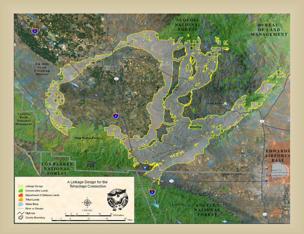
Tehachapi Connection
This linkage has statewide importance as the sole wildland connection between the Sierra Nevada-Cascade system that stretches for over 2000 miles from Kern County into British Columbia, and the 800 mile long upland system comprised of the Sierra Madre (the coast ranges from San Francisco to Los Angeles), Transverse (Santa Monica, San Gabriel, San Bernardino, and San Jacintos Mountains), and Peninsular Ranges (Santa Ana, Palomar, and Laguna Mountains of San Diego County, and the Sierra Juarez of Baja). This linkage is also situated at the juncture of several ecoregions, including the Sierra Nevada, South Coast, Central Valley, and the Mojave Desert. The Tehachapis have been described as a “biogeographic crossroads” and a “crucible of evolution”, and are home to a stunning variety of plant and animal life (White et al. 2003). As might be expected in this remarkable landscape, the Linkage Design encompasses a diversity of natural communities, including over 30 vegetation types. About 15% (102,355 out of 663,257 total acres) of the Linkage Design currently enjoys some level of conservation protection, mostly in land administered by the Bureau of Land Management.
Looking down Bear Trap Canyon in the Tehachapi Mountains toward the Sierra Madre Ranges, Los Padres National Forest (Photo Andrew Harvey, VisualJourneys.net). The Linkage Design has four main strands, which tend to follow elevational contours that connect along areas of similar ecological conditions. One strand includes a swath of grassland and foothill habitats along the southern rim of the San Joaquin Valley to serve the suite of grassland-dependent species clinging to existence there, such as the endangered San Joaquin kit fox and blunt-nosed leopard lizard. A second strand connects a series of higher elevation forest and shrubland habitats serving species, such as puma, western gray squirrel, and mule deer. A third strand follows the desert-side slopes of the Tehachapis, connecting habitats for species, such as
7
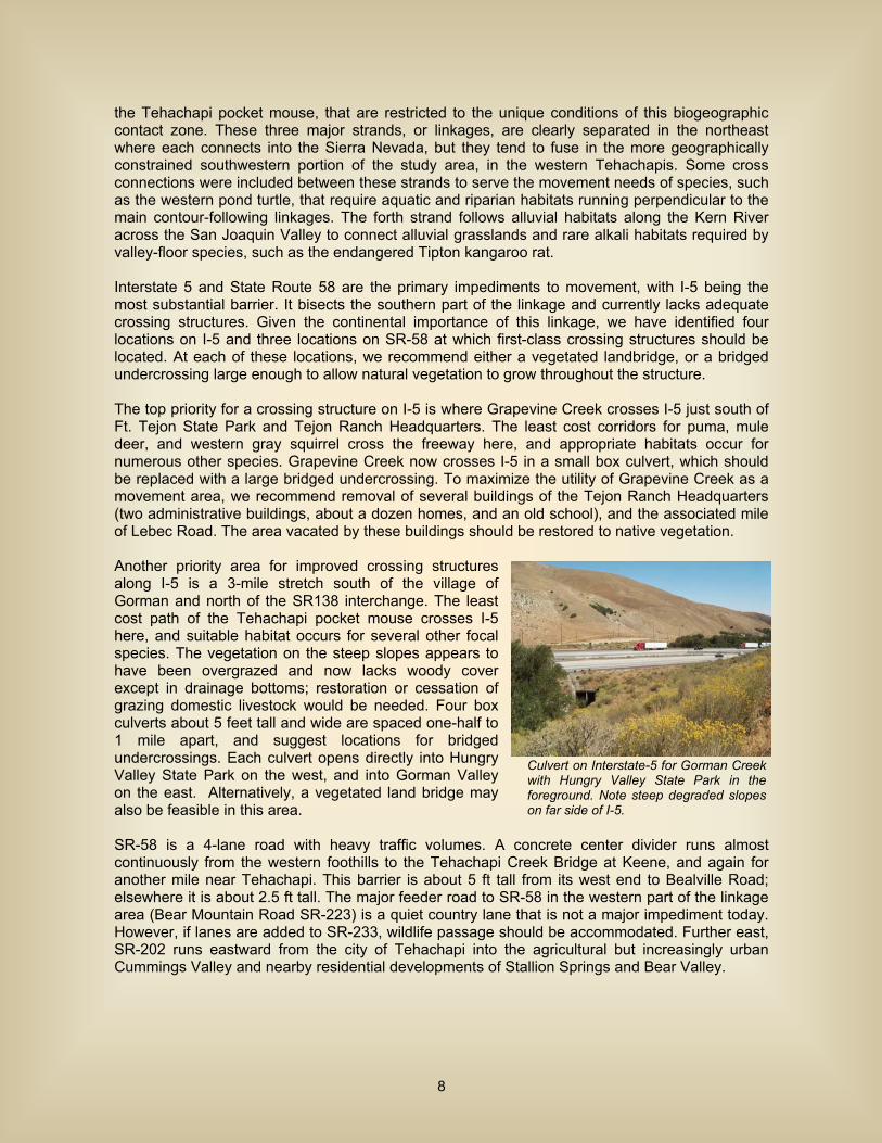
the Tehachapi pocket mouse, that are restricted to the unique conditions of this biogeographic contact zone. These three major strands, or linkages, are clearly separated in the northeast where each connects into the Sierra Nevada, but they tend to fuse in the more geographically constrained southwestern portion of the study area, in the western Tehachapis. Some cross connections were included between these strands to serve the movement needs of species, such as the western pond turtle, that require aquatic and riparian habitats running perpendicular to the main contour-following linkages. The forth strand follows alluvial habitats along the Kern River across the San Joaquin Valley to connect alluvial grasslands and rare alkali habitats required by valley-floor species, such as the endangered Tipton kangaroo rat. Interstate 5 and State Route 58 are the primary impediments to movement, with I-5 being the most substantial barrier. It bisects the southern part of the linkage and currently lacks adequate crossing structures. Given the continental importance of this linkage, we have identified four locations on I-5 and three locations on SR-58 at which first-class crossing structures should be located. At each of these locations, we recommend either a vegetated landbridge, or a bridged undercrossing large enough to allow natural vegetation to grow throughout the structure. The top priority for a crossing structure on I-5 is where Grapevine Creek crosses I-5 just south of Ft. Tejon State Park and Tejon Ranch Headquarters. The least cost corridors for puma, mule deer, and western gray squirrel cross the freeway here, and appropriate habitats occur for numerous other species. Grapevine Creek now crosses I-5 in a small box culvert, which should be replaced with a large bridged undercrossing. To maximize the utility of Grapevine Creek as a movement area, we recommend removal of several buildings of the Tejon Ranch Headquarters (two administrative buildings, about a dozen homes, and an old school), and the associated mile of Lebec Road. The area vacated by these buildings should be restored to native vegetation. Another priority area for improved crossing structures along I-5 is a 3-mile stretch south of the village of Gorman and north of the SR138 interchange. The least cost path of the Tehachapi pocket mouse crosses I-5 here, and suitable habitat occurs for several other focal species. The vegetation on the steep slopes appears to have been overgrazed and now lacks woody cover except in drainage bottoms; restoration or cessation of grazing domestic livestock would be needed. Four box culverts about 5 feet tall and wide are spaced one-half to 1 mile apart, and suggest locations for bridged undercrossings. Each culvert opens directly into Hungry Valley State Park on the west, and into Gorman Valley on the east. Alternatively, a vegetated land bridge may also be feasible in this area. SR-58 is a 4-lane road with heavy traffic volumes. A concrete center divider runs almost continuously from the western foothills to the Tehachapi Creek Bridge at Keene, and again for another mile near Tehachapi. This barrier is about 5 ft tall from its west end to Bealville Road; elsewhere it is about 2.5 ft tall. The major feeder road to SR-58 in the western part of the linkage area (Bear Mountain Road SR-223) is a quiet country lane that is not a major impediment today. However, if lanes are added to SR-233, wildlife passage should be accommodated. Further east, SR-202 runs eastward from the city of Tehachapi into the agricultural but increasingly urban Cummings Valley and nearby residential developments of Stallion Springs and Bear Valley.
Culvert on Interstate-5 for Gorman Creek with Hungry Valley State Park in the foreground. Note steep degraded slopes on far side of I-5.
8
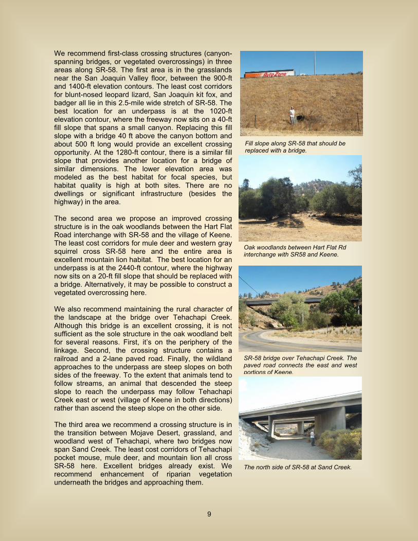
We recommend first-class crossing structures (canyon-spanning bridges, or vegetated overcrossings) in three areas along SR-58. The first area is in the grasslands near the San Joaquin Valley floor, between the 900-ft and 1400-ft elevation contours. The least cost corridors for blunt-nosed leopard lizard, San Joaquin kit fox, and badger all lie in this 2.5-mile wide stretch of SR-58. The best location for an underpass is at the 1020-ft elevation contour, where the freeway now sits on a 40-ft fill slope that spans a small canyon. Replacing this fill slope with a bridge 40 ft above the canyon bottom and about 500 ft long would provide an excellent crossing opportunity. At the 1280-ft contour, there is a similar fill slope that provides another location for a bridge of similar dimensions. The lower elevation area was modeled as the best habitat for focal species, but habitat quality is high at both sites. There are no dwellings or significant infrastructure (besides the highway) in the area. The second area we propose an improved crossing structure is in the oak woodlands between the Hart Flat Road interchange with SR-58 and the village of Keene. The least cost corridors for mule deer and western gray squirrel cross SR-58 here and the entire area is excellent mountain lion habitat. The best location for an underpass is at the 2440-ft contour, where the highway now sits on a 20-ft fill slope that should be replaced with a bridge. Alternatively, it may be possible to construct a vegetated overcrossing here. We also recommend maintaining the rural character of the landscape at the bridge over Tehachapi Creek. Although this bridge is an excellent crossing, it is not sufficient as the sole structure in the oak woodland belt for several reasons. First, it’s on the periphery of the linkage. Second, the crossing structure contains a railroad and a 2-lane paved road. Finally, the wildland approaches to the underpass are steep slopes on both sides of the freeway. To the extent that animals tend to follow streams, an animal that descended the steep slope to reach the underpass may follow Tehachapi Creek east or west (village of Keene in both directions) rather than ascend the steep slope on the other side. The third area we recommend a crossing structure is in the transition between Mojave Desert, grassland, and woodland west of Tehachapi, where two bridges now span Sand Creek. The least cost corridors of Tehachapi pocket mouse, mule deer, and mountain lion all cross SR-58 here. Excellent bridges already exist. We recommend enhancement of riparian vegetation underneath the bridges and approaching them.
Fill slope along SR-58 that should be replaced with a bridge.
Oak woodlands between Hart Flat Rd interchange with SR58 and Keene.
SR-58 bridge over Tehachapi Creek. The paved road connects the east and west portions of Keene.
The north side of SR-58 at Sand Creek.
9
Santa Monica-Sierra Madre Connection
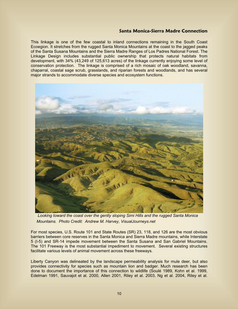
This linkage is one of the few coastal to inland connections remaining in the South Coast Ecoegion. It stretches from the rugged Santa Monica Mountains at the coast to the jagged peaks of the Santa Susana Mountains and the Sierra Madre Ranges of Los Padres National Forest. The Linkage Design includes substantial public ownership that protects natural habitats from development, with 34% (43,249 of 125,613 acres) of the linkage currently enjoying some level of conservation protection. The linkage is comprised of a rich mosaic of oak woodland, savanna, chaparral, coastal sage scrub, grasslands, and riparian forests and woodlands, and has several major strands to accommodate diverse species and ecosystem functions.
Looking toward the coast over the gently sloping Simi Hills and the rugged Santa Monica Mountains. Photo Credit: Andrew M. Harvey, VisualJourneys.net For most species, U.S. Route 101 and State Routes (SR) 23, 118, and 126 are the most obvious barriers between core reserves in the Santa Monica and Sierra Madre mountains, while Interstate 5 (I-5) and SR-14 impede movement between the Santa Susana and San Gabriel Mountains. The 101 Freeway is the most substantial impediment to movement. Several existing structures facilitate various levels of animal movement across these freeways. Liberty Canyon was delineated by the landscape permeability analysis for mule deer, but also provides connectivity for species such as mountain lion and badger. Much research has been done to document the importance of this connection to wildlife (Soulé 1989, Kohn et al. 1999, Edelman 1991, Sauvajot et al. 2000, Allen 2001, Riley et al. 2003, Ng et al. 2004, Riley et al.
10
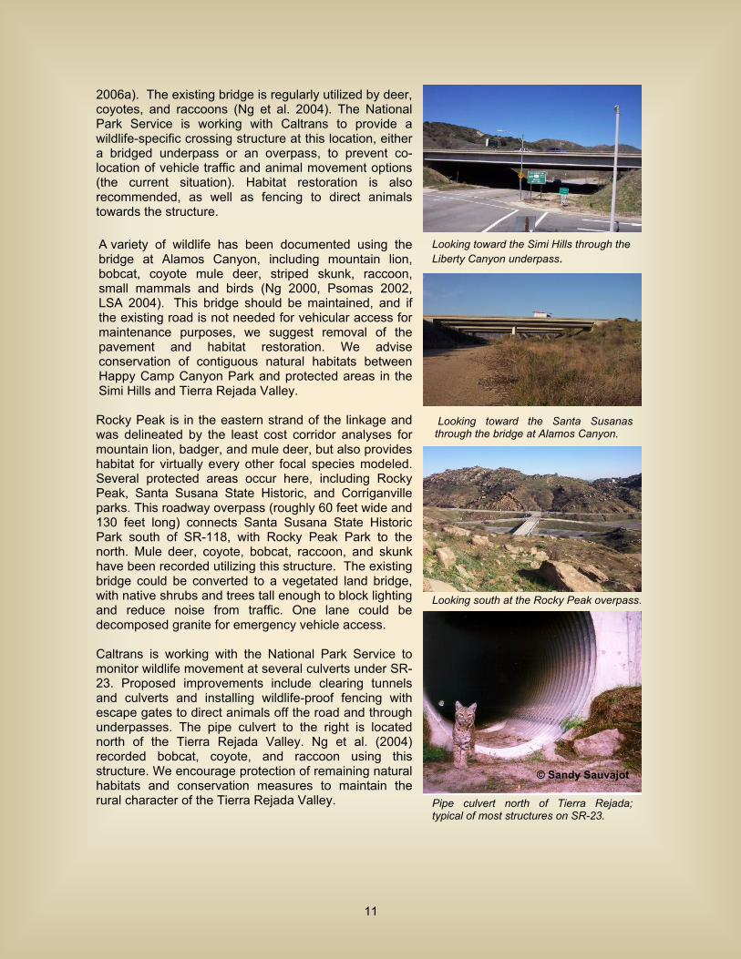
2006a). The existing bridge is regularly utilized by deer, coyotes, and raccoons (Ng et al. 2004). The National Park Service is working with Caltrans to provide a wildlife-specific crossing structure at this location, either a bridged underpass or an overpass, to prevent co-location of vehicle traffic and animal movement options (the current situation). Habitat restoration is also recommended, as well as fencing to direct animals towards the structure. A variety of wildlife has been documented using the bridge at Alamos Canyon, including mountain lion, bobcat, coyote mule deer, striped skunk, raccoon, small mammals and birds (Ng 2000, Psomas 2002, LSA 2004). This bridge should be maintained, and if the existing road is not needed for vehicular access for maintenance purposes, we suggest removal of the pavement and habitat restoration. We advise conservation of contiguous natural habitats between Happy Camp Canyon Park and protected areas in the Simi Hills and Tierra Rejada Valley. Rocky Peak is in the eastern strand of the linkage and was delineated by the least cost corridor analyses for mountain lion, badger, and mule deer, but also provides habitat for virtually every other focal species modeled. Several protected areas occur here, including Rocky Peak, Santa Susana State Historic, and Corriganville parks. This roadway overpass (roughly 60 feet wide and 130 feet long) connects Santa Susana State Historic Park south of SR-118, with Rocky Peak Park to the north. Mule deer, coyote, bobcat, raccoon, and skunk have been recorded utilizing this structure. The existing bridge could be converted to a vegetated land bridge, with native shrubs and trees tall enough to block lighting and reduce noise from traffic. One lane could be decomposed granite for emergency vehicle access. Caltrans is working with the National Park Service to monitor wildlife movement at several culverts under SR-23. Proposed improvements include clearing tunnels and culverts and installing wildlife-proof fencing with escape gates to direct animals off the road and through underpasses. The pipe culvert to the right is located north of the Tierra Rejada Valley. Ng et al. (2004) recorded bobcat, coyote, and raccoon using this structure. We encourage protection of remaining natural habitats and conservation measures to maintain the rural character of the Tierra Rejada Valley.
© Sandy Sauvajot
Pipe culvert north of Tierra Rejada; typical of most structures on SR-23.
Looking toward the Santa Susanas through the bridge at Alamos Canyon.
Looking south at the Rocky Peak overpass.
Looking toward the Simi Hills through the Liberty Canyon underpass.
11

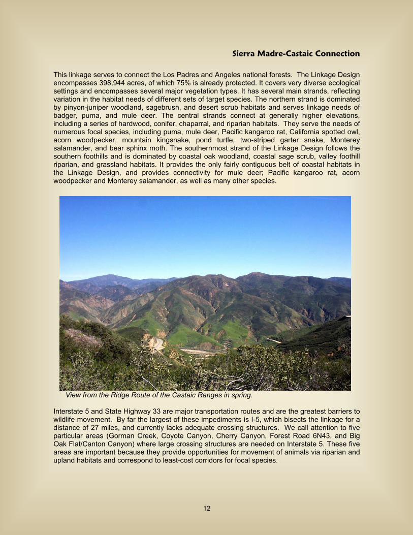
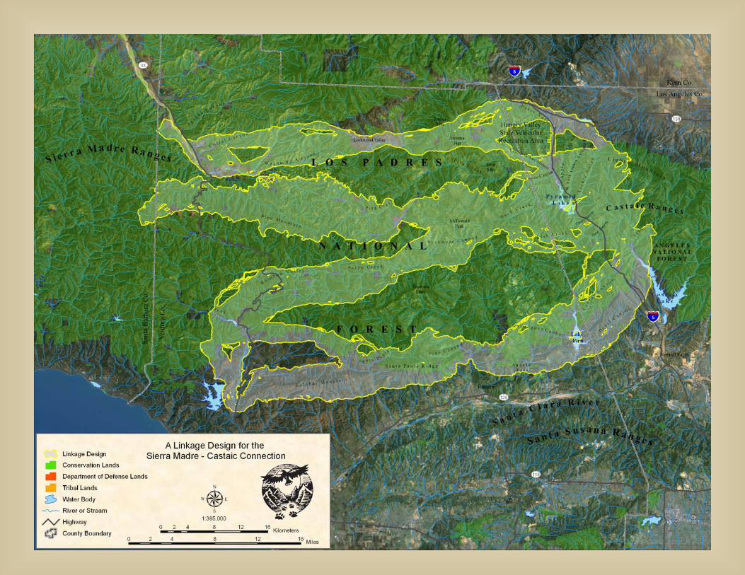
Sierra Madre-Castaic Connection
This linkage serves to connect the Los Padres and Angeles national forests. The Linkage Design encompasses 398,944 acres, of which 75% is already protected. It covers very diverse ecological settings and encompasses several major vegetation types. It has several main strands, reflecting variation in the habitat needs of different sets of target species. The northern strand is dominated by pinyon-juniper woodland, sagebrush, and desert scrub habitats and serves linkage needs of badger, puma, and mule deer. The central strands connect at generally higher elevations, including a series of hardwood, conifer, chaparral, and riparian habitats. They serve the needs of numerous focal species, including puma, mule deer, Pacific kangaroo rat, California spotted owl, acorn woodpecker, mountain kingsnake, pond turtle, two-striped garter snake, Monterey salamander, and bear sphinx moth. The southernmost strand of the Linkage Design follows the southern foothills and is dominated by coastal oak woodland, coastal sage scrub, valley foothill riparian, and grassland habitats. It provides the only fairly contiguous belt of coastal habitats in the Linkage Design, and provides connectivity for mule deer; Pacific kangaroo rat, acorn woodpecker and Monterey salamander, as well as many other species.
View from the Ridge Route of the Castaic Ranges in spring. Interstate 5 and State Highway 33 are major transportation routes and are the greatest barriers to wildlife movement. By far the largest of these impediments is I-5, which bisects the linkage for a distance of 27 miles, and currently lacks adequate crossing structures. We call attention to five particular areas (Gorman Creek, Coyote Canyon, Cherry Canyon, Forest Road 6N43, and Big Oak Flat/Canton Canyon) where large crossing structures are needed on Interstate 5. These five areas are important because they provide opportunities for movement of animals via riparian and upland habitats and correspond to least-cost corridors for focal species.
12
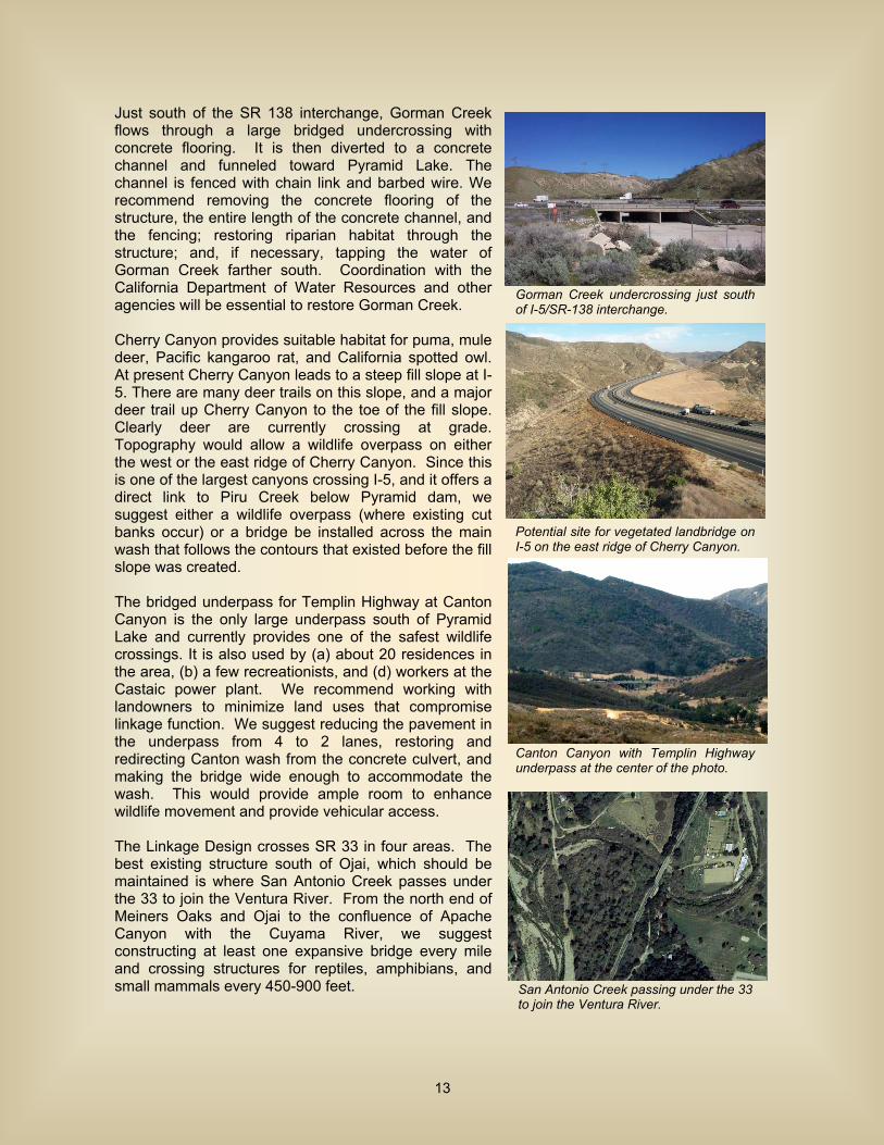
Just south of the SR 138 interchange, Gorman Creek flows through a large bridged undercrossing with concrete flooring. It is then diverted to a concrete channel and funneled toward Pyramid Lake. The channel is fenced with chain link and barbed wire. We recommend removing the concrete flooring of the structure, the entire length of the concrete channel, and the fencing; restoring riparian habitat through the structure; and, if necessary, tapping the water of Gorman Creek farther south. Coordination with the California Department of Water Resources and other agencies will be essential to restore Gorman Creek. Cherry Canyon provides suitable habitat for puma, mule deer, Pacific kangaroo rat, and California spotted owl. At present Cherry Canyon leads to a steep fill slope at I-5. There are many deer trails on this slope, and a major deer trail up Cherry Canyon to the toe of the fill slope. Clearly deer are currently crossing at grade. Topography would allow a wildlife overpass on either the west or the east ridge of Cherry Canyon. Since this is one of the largest canyons crossing I-5, and it offers a direct link to Piru Creek below Pyramid dam, we suggest either a wildlife overpass (where existing cut banks occur) or a bridge be installed across the main wash that follows the contours that existed before the fill slope was created. The bridged underpass for Templin Highway at Canton Canyon is the only large underpass south of Pyramid Lake and currently provides one of the safest wildlife crossings. It is also used by (a) about 20 residences in the area, (b) a few recreationists, and (d) workers at the Castaic power plant. We recommend working with landowners to minimize land uses that compromise linkage function. We suggest reducing the pavement in the underpass from 4 to 2 lanes, restoring and redirecting Canton wash from the concrete culvert, and making the bridge wide enough to accommodate the wash. This would provide ample room to enhance wildlife movement and provide vehicular access. The Linkage Design crosses SR 33 in four areas. The best existing structure south of Ojai, which should be maintained is where San Antonio Creek passes under the 33 to join the Ventura River. From the north end of Meiners Oaks and Ojai to the confluence of Apache Canyon with the Cuyama River, we suggest constructing at least one expansive bridge every mile and crossing structures for reptiles, amphibians, and small mammals every 450-900 feet.
Gorman Creek undercrossing just south of I-5/SR-138 interchange.
Potential site for vegetated landbridge on I-5 on the east ridge of Cherry Canyon.
Canton Canyon with Templin Highway underpass at the center of the photo.
San Antonio Creek passing under the 33 to join the Ventura River.
13
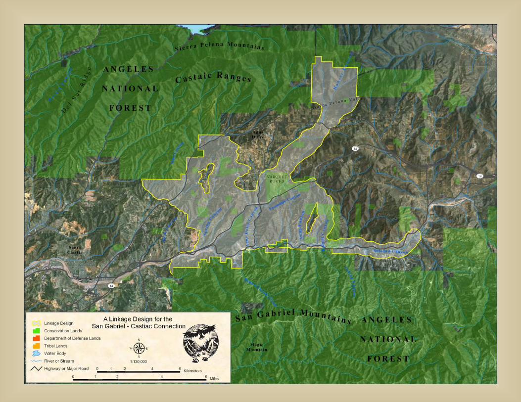
San Gabriel-Castaic Connection
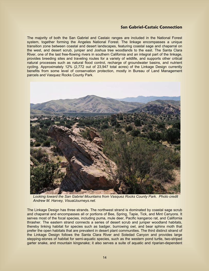
The majority of both the San Gabriel and Castaic ranges are included in the National Forest system, together forming the Angeles National Forest. The linkage encompasses a unique transition zone between coastal and desert landscapes, featuring coastal sage and chaparral on the west, and desert scrub, juniper and Joshua tree woodlands to the east. The Santa Clara River, one of the last free-flowing rivers in southern California and an integral part of the linkage, provides breeding sites and traveling routes for a variety of wildlife, and supports other critical natural processes such as natural flood control, recharge of groundwater basins, and nutrient cycling. Approximately 12% (2,772 out of 23,947 total acres) of the Linkage Design currently benefits from some level of conservation protection, mostly in Bureau of Land Management parcels and Vasquez Rocks County Park.
Looking toward the San Gabriel Mountains from Vasquez Rocks County Park. Photo credit Andrew M. Harvey, VisualJourneys.net. The Linkage Design has three strands. The northwest strand is dominated by coastal sage scrub and chaparral and encompasses all or portions of Bee, Spring, Tapie, Tick, and Mint Canyons. It serves most of the focal species, including puma, mule deer, Pacific kangaroo rat, and California thrasher. The eastern strand connects a series of desert scrub and juniper woodland habitats, thereby linking habitat for species such as badger, burrowing owl, and bear sphinx moth that prefer the open habitats that are prevalent in desert plant communities. The third distinct strand of the Linkage Design follows the Santa Clara River and Soledad Canyon and provides large stepping-stones of habitat for semi-aquatic species, such as the western pond turtle, two-striped garter snake, and mountain kingsnake; it also serves a suite of aquatic and riparian-dependent
14
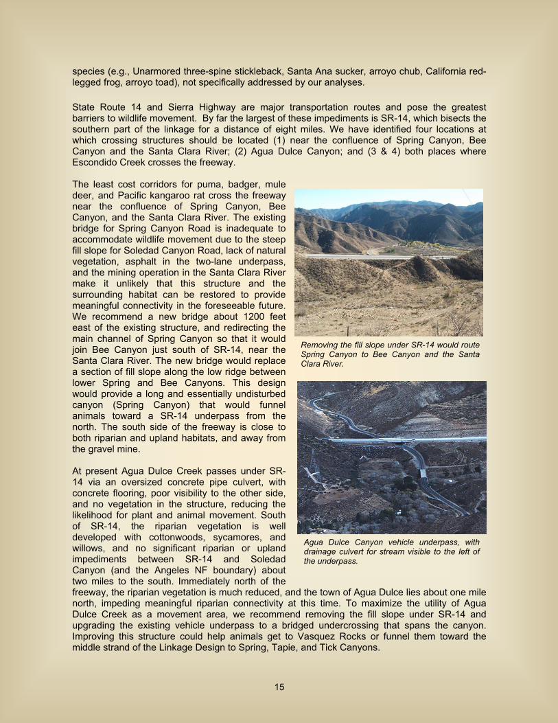
species (e.g., Unarmored three-spine stickleback, Santa Ana sucker, arroyo chub, California red-legged frog, arroyo toad), not specifically addressed by our analyses. State Route 14 and Sierra Highway are major transportation routes and pose the greatest barriers to wildlife movement. By far the largest of these impediments is SR-14, which bisects the southern part of the linkage for a distance of eight miles. We have identified four locations at which crossing structures should be located (1) near the confluence of Spring Canyon, Bee Canyon and the Santa Clara River; (2) Agua Dulce Canyon; and (3 & 4) both places where Escondido Creek crosses the freeway. The least cost corridors for puma, badger, mule deer, and Pacific kangaroo rat cross the freeway near the confluence of Spring Canyon, Bee Canyon, and the Santa Clara River. The existing bridge for Spring Canyon Road is inadequate to accommodate wildlife movement due to the steep fill slope for Soledad Canyon Road, lack of natural vegetation, asphalt in the two-lane underpass, and the mining operation in the Santa Clara River make it unlikely that this structure and the surrounding habitat can be restored to provide meaningful connectivity in the foreseeable future. We recommend a new bridge about 1200 feet east of the existing structure, and redirecting the main channel of Spring Canyon so that it would join Bee Canyon just south of SR-14, near the Santa Clara River. The new bridge would replace a section of fill slope along the low ridge between lower Spring and Bee Canyons. This design would provide a long and essentially undisturbed canyon (Spring Canyon) that would funnel animals toward a SR-14 underpass from the north. The south side of the freeway is close to both riparian and upland habitats, and away from the gravel mine. At present Agua Dulce Creek passes under SR-14 via an oversized concrete pipe culvert, with concrete flooring, poor visibility to the other side, and no vegetation in the structure, reducing the likelihood for plant and animal movement. South of SR-14, the riparian vegetation is well developed with cottonwoods, sycamores, and willows, and no significant riparian or upland impediments between SR-14 and Soledad Canyon (and the Angeles NF boundary) about two miles to the south. Immediately north of the freeway, the riparian vegetation is much reduced, and the town of Agua Dulce lies about one mile north, impeding meaningful riparian connectivity at this time. To maximize the utility of Agua Dulce Creek as a movement area, we recommend removing the fill slope under SR-14 and upgrading the existing vehicle underpass to a bridged undercrossing that spans the canyon. Improving this structure could help animals get to Vasquez Rocks or funnel them toward the middle strand of the Linkage Design to Spring, Tapie, and Tick Canyons.
Removing the fill slope under SR-14 would route Spring Canyon to Bee Canyon and the Santa Clara River.
Agua Dulce Canyon vehicle underpass, with drainage culvert for stream visible to the left of the underpass.
15
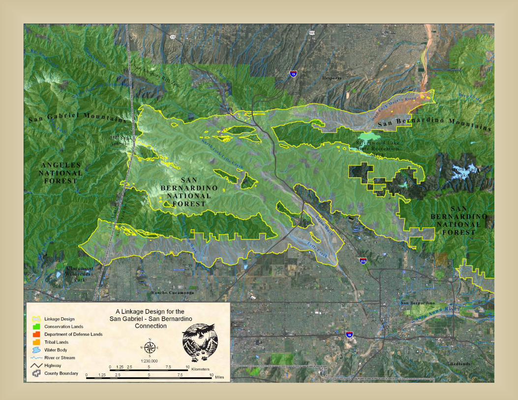
San Gabriel-San Bernardino Connection
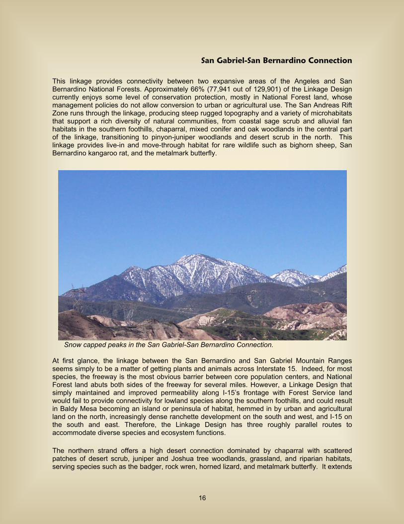
This linkage provides connectivity between two expansive areas of the Angeles and San Bernardino National Forests. Approximately 66% (77,941 out of 129,901) of the Linkage Design currently enjoys some level of conservation protection, mostly in National Forest land, whose management policies do not allow conversion to urban or agricultural use. The San Andreas Rift Zone runs through the linkage, producing steep rugged topography and a variety of microhabitats that support a rich diversity of natural communities, from coastal sage scrub and alluvial fan habitats in the southern foothills, chaparral, mixed conifer and oak woodlands in the central part of the linkage, transitioning to pinyon-juniper woodlands and desert scrub in the north. This linkage provides live-in and move-through habitat for rare wildlife such as bighorn sheep, San Bernardino kangaroo rat, and the metalmark butterfly.
Snow capped peaks in the San Gabriel-San Bernardino Connection. At first glance, the linkage between the San Bernardino and San Gabriel Mountain Ranges seems simply to be a matter of getting plants and animals across Interstate 15. Indeed, for most species, the freeway is the most obvious barrier between core population centers, and National Forest land abuts both sides of the freeway for several miles. However, a Linkage Design that simply maintained and improved permeability along I-15’s frontage with Forest Service land would fail to provide connectivity for lowland species along the southern foothills, and could result in Baldy Mesa becoming an island or peninsula of habitat, hemmed in by urban and agricultural land on the north, increasingly dense ranchette development on the south and west, and I-15 on the south and east. Therefore, the Linkage Design has three roughly parallel routes to accommodate diverse species and ecosystem functions. The northern strand offers a high desert connection dominated by chaparral with scattered patches of desert scrub, juniper and Joshua tree woodlands, grassland, and riparian habitats, serving species such as the badger, rock wren, horned lizard, and metalmark butterfly. It extends
16

from the Upper North Fork of Lytle Creek, across Stockton Flat, down into Lone Pine Canyon, across Cajon Pass to Horsethief Canyon, up into Summit Valley and then on to the West Fork of the Mojave River. The central strand links a series of higher elevation forest and shrubland habitats serving numerous species, including puma, mule deer, spotted owl, mountain quail, and wrentit. This strand also offers the best potential connection for bighorn sheep, pygmy nuthatch, treefrog, whipsnake, and speckled dace. It encompasses the majority of land between Upper Lytle Creek Ridge, lower Lone Pine Canyon, Crowder and Cleghorn Canyons in the north and Cucamonga and Arrowhead Peaks in the south. The southern strand encompasses coastal and alluvial fan scrub habitats from San Antonio, Cucamonga, Deer, Day, Etiwanda, Morse, and San Sevaine creeks, to Lytle Creek and Cajon Wash, serving the movement needs of the endangered San Bernardino kangaroo rat and slender-horned spineflower, as well as the Pacific kangaroo rat, tarantula hawk, giant flower-loving fly, and California sagebrush. Interstate 15 and State Route 138 are the major transportation routes and pose the most substantial barriers to wildlife movement. Interstate 15 is by far the most severe impediment, bisecting the linkage for a distance of roughly 17 miles, with 46 million vehicles a year traveling through the pass (USDA Forest Service 2004). Currently, State Route 138 (Rim of the World) is a two-lane road that receives light tourist traffic, though substantial increases in traffic and upgrading of the highway are planned. The US Forest Service is working with the Department of Transportation and Biological Resources division of US Geological Survey to design adequate linkages that will include one or more bridges and other large crossing structures to accommodate wildlife movement. Historic Route 66 and several major rail lines run alongside the freeway in many areas, adding to the barrier effect. There are currently three bridges along I-15 that accommodate animal movement. All three occur within a one and a half mile long section of the highway south of the Cajon interchange. By far the best of these is the bridge at Cleghorn Canyon. The Least Cost Corridors for puma, mule deer, and bighorn sheep cross I-15 at Cleghorn Canyon, and there is a perennial spring in the upper canyon that draws animals into the drainage. Until new or upgraded crossing structures are available, it is critical that this structure be maintained and that the private and public lands near it are protected from urban development. The other two bridged crossings lie to the north of Cleghorn Canyon and south of the site of old Cajon. Compared to the bridge at Cleghorn Canyon, these bridges have shorter spans, less clearance above the wash, and the canyons drain much smaller watersheds (100 to 300 acres, compared to about 1500 acres for Cleghorn). They may be expected to serve focal species, such as the Pacific kangaroo rat, San Diego horned lizard, and Chaparral whipsnake.
View down Cleghorn Canyon under I-15.
Bridges on I-15 north of Cleghorn Canyon; the top is 0.7 miles north of Cleghorn; the bottom is 400 yards south of the Cajon interchange.
17
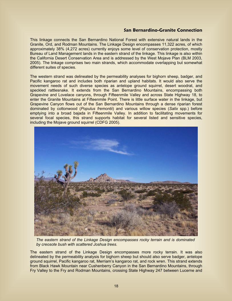
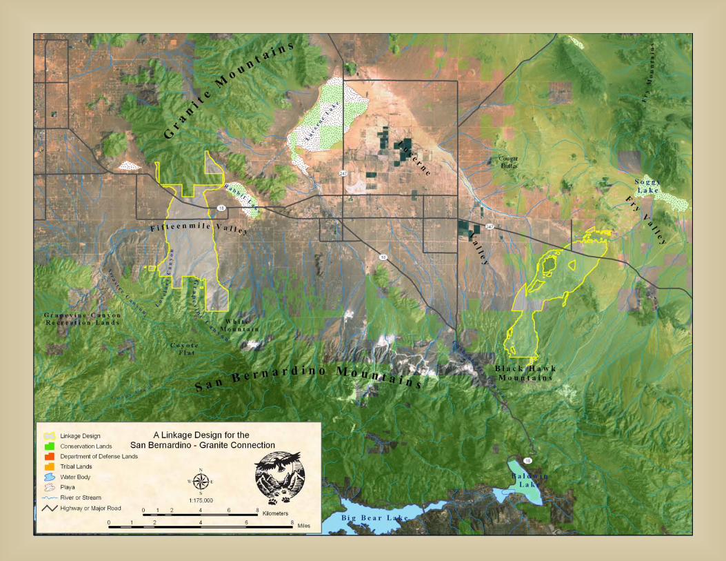
San Bernardino-Granite Connection
This linkage connects the San Bernardino National Forest with extensive natural lands in the Granite, Ord, and Rodman Mountains. The Linkage Design encompasses 11,322 acres, of which approximately 38% (4,272 acres) currently enjoys some level of conservation protection, mostly Bureau of Land Management lands in the eastern strand of the linkage. This linkage is also within the California Desert Conservation Area and is addressed by the West Mojave Plan (BLM 2003, 2005). The linkage comprises two main strands, which accommodate overlapping but somewhat different suites of species. The western strand was delineated by the permeability analyses for bighorn sheep, badger, and Pacific kangaroo rat and includes both riparian and upland habitats. It would also serve the movement needs of such diverse species as antelope ground squirrel, desert woodrat, and speckled rattlesnake. It extends from the San Bernardino Mountains, encompassing both Grapevine and Lovelace canyons, through Fifteenmile Valley and across State Highway 18, to enter the Granite Mountains at Fifteenmile Point. There is little surface water in the linkage, but Grapevine Canyon flows out of the San Bernardino Mountains through a dense riparian forest dominated by cottonwood (Populus fremontii) and various willow species (Salix spp.) before emptying into a broad bajada in Fifteenmile Valley. In addition to facilitating movements for several focal species, this strand supports habitat for several listed and sensitive species, including the Mojave ground squirrel (CDFG 2005).
The eastern strand of the Linkage Design encompasses more rocky terrain. It was also delineated by the permeability analysis for bighorn sheep but should also serve badger, antelope ground squirrel, Pacific kangaroo rat, Merriam’s kangaroo rat, and rock wren. This strand extends from Black Hawk Mountain near Cushenberry Canyon in the San Bernardino Mountains, through Fry Valley to the Fry and Rodman Mountains, crossing State Highway 247 between Lucerne and
The eastern strand of the Linkage Design encompasses rocky terrain and is dominated by creosote bush with scattered Joshua trees.
18
Johnson Valleys. It encompasses Joshua tree woodland and pinyon-juniper woodland in the foothills of the San Bernardino Mountains, desert scrub through the valley and Fry Mountains, and sagebrush habitats in the Rodman Mountains. The eastern strand of the linkage includes substantial public ownerships that protect natural habitats from development.
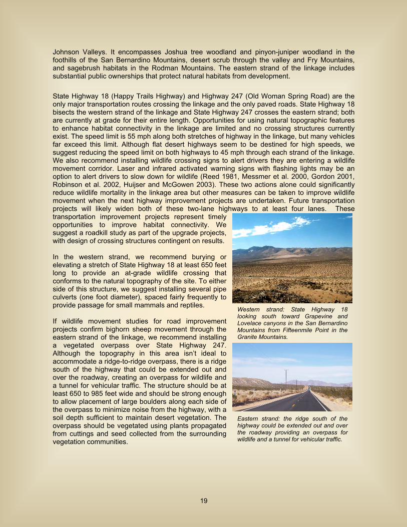
State Highway 18 (Happy Trails Highway) and Highway 247 (Old Woman Spring Road) are the only major transportation routes crossing the linkage and the only paved roads. State Highway 18 bisects the western strand of the linkage and State Highway 247 crosses the eastern strand; both are currently at grade for their entire length. Opportunities for using natural topographic features to enhance habitat connectivity in the linkage are limited and no crossing structures currently exist. The speed limit is 55 mph along both stretches of highway in the linkage, but many vehicles far exceed this limit. Although flat desert highways seem to be destined for high speeds, we suggest reducing the speed limit on both highways to 45 mph through each strand of the linkage. We also recommend installing wildlife crossing signs to alert drivers they are entering a wildlife movement corridor. Laser and infrared activated warning signs with flashing lights may be an option to alert drivers to slow down for wildlife (Reed 1981, Messmer et al. 2000, Gordon 2001, Robinson et al. 2002, Huijser and McGowen 2003). These two actions alone could significantly reduce wildlife mortality in the linkage area but other measures can be taken to improve wildlife movement when the next highway improvement projects are undertaken. Future transportation projects will likely widen both of these two-lane highways to at least four lanes. These transportation improvement projects represent timely opportunities to improve habitat connectivity. We suggest a roadkill study as part of the upgrade projects, with design of crossing structures contingent on results. In the western strand, we recommend burying or elevating a stretch of State Highway 18 at least 650 feet long to provide an at-grade wildlife crossing that conforms to the natural topography of the site. To either side of this structure, we suggest installing several pipe culverts (one foot diameter), spaced fairly frequently to provide passage for small mammals and reptiles. If wildlife movement studies for road improvement projects confirm bighorn sheep movement through the eastern strand of the linkage, we recommend installing a vegetated overpass over State Highway 247. Although the topography in this area isn’t ideal to accommodate a ridge-to-ridge overpass, there is a ridge south of the highway that could be extended out and over the roadway, creating an overpass for wildlife and a tunnel for vehicular traffic. The structure should be at least 650 to 985 feet wide and should be strong enough to allow placement of large boulders along each side of the overpass to minimize noise from the highway, with a soil depth sufficient to maintain desert vegetation. The overpass should be vegetated using plants propagated from cuttings and seed collected from the surrounding vegetation communities.
Western strand: State Highway 18 looking south toward Grapevine and Lovelace canyons in the San Bernardino Mountains from Fifteenmile Point in the Granite Mountains.
Eastern strand: the ridge south of the highway could be extended out and over the roadway providing an overpass for wildlife and a tunnel for vehicular traffic.
19
San Bernardino-Little San Bernardino Connection
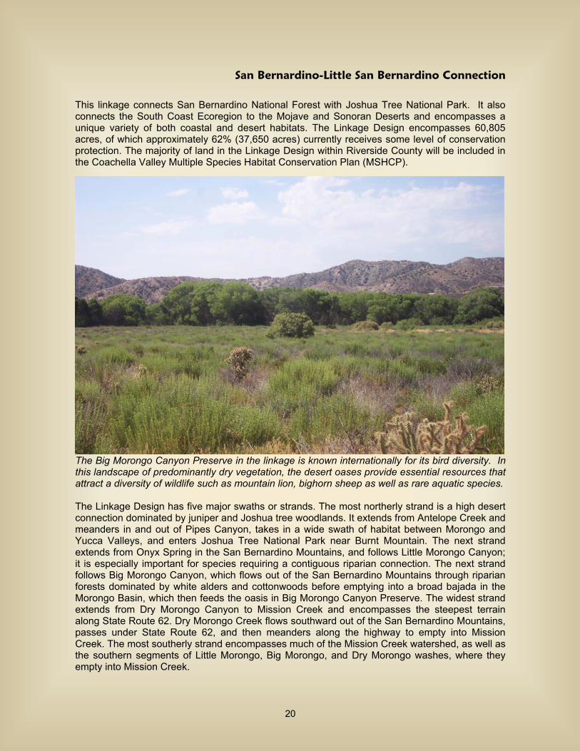
This linkage connects San Bernardino National Forest with Joshua Tree National Park. It also connects the South Coast Ecoregion to the Mojave and Sonoran Deserts and encompasses a unique variety of both coastal and desert habitats. The Linkage Design encompasses 60,805 acres, of which approximately 62% (37,650 acres) currently receives some level of conservation protection. The majority of land in the Linkage Design within Riverside County will be included in the Coachella Valley Multiple Species Habitat Conservation Plan (MSHCP).
The Big Morongo Canyon Preserve in the linkage is known internationally for its bird diversity. In this landscape of predominantly dry vegetation, the desert oases provide essential resources that attract a diversity of wildlife such as mountain lion, bighorn sheep as well as rare aquatic species. The Linkage Design has five major swaths or strands. The most northerly strand is a high desert connection dominated by juniper and Joshua tree woodlands. It extends from Antelope Creek and meanders in and out of Pipes Canyon, takes in a wide swath of habitat between Morongo and Yucca Valleys, and enters Joshua Tree National Park near Burnt Mountain. The next strand extends from Onyx Spring in the San Bernardino Mountains, and follows Little Morongo Canyon; it is especially important for species requiring a contiguous riparian connection. The next strand follows Big Morongo Canyon, which flows out of the San Bernardino Mountains through riparian forests dominated by white alders and cottonwoods before emptying into a broad bajada in the Morongo Basin, which then feeds the oasis in Big Morongo Canyon Preserve. The widest strand extends from Dry Morongo Canyon to Mission Creek and encompasses the steepest terrain along State Route 62. Dry Morongo Creek flows southward out of the San Bernardino Mountains, passes under State Route 62, and then meanders along the highway to empty into Mission Creek. The most southerly strand encompasses much of the Mission Creek watershed, as well as the southern segments of Little Morongo, Big Morongo, and Dry Morongo washes, where they empty into Mission Creek.
20
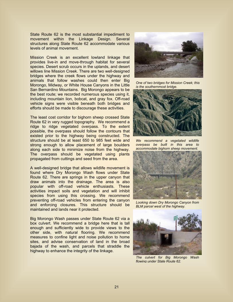
State Route 62 is the most substantial impediment to movement within the Linkage Design. Several structures along State Route 62 accommodate various levels of animal movement. Mission Creek is an excellent lowland linkage that provides live-in and move-through habitat for several species. Desert scrub occurs in the uplands, and desert willows line Mission Creek. There are two well-designed bridges where the creek flows under the highway and animals that follow washes could then enter Big Morongo, Midway, or White House Canyons in the Little San Bernardino Mountains. Big Morongo appears to be the best route; we recorded numerous species using it, including mountain lion, bobcat, and gray fox. Off-road vehicle signs were visible beneath both bridges and efforts should be made to discourage these activities. The least cost corridor for bighorn sheep crossed State Route 62 in very rugged topography. We recommend a ridge to ridge vegetated overpass. To the extent possible, the overpass should follow the contours that existed prior to the highway being constructed. The structure should be at least 650 to 985 feet wide and strong enough to allow placement of large boulders along each side to minimize noise from the highway. The overpass should be vegetated using plants propagated from cuttings and seed from the area. A well-designed bridge that allows wildlife movement is found where Dry Morongo Wash flows under State Route 62. There are springs in the upper canyon that draw animals into the drainage. The area is also popular with off-road vehicle enthusiasts. These activities impact soils and vegetation and will inhibit species from using this crossing. We recommend preventing off-road vehicles from entering the canyon and enforcing closures. This structure should be maintained and lands near it protected. Big Morongo Wash passes under State Route 62 via a box culvert. We recommend a bridge here that is tall enough and sufficiently wide to provide views to the other side, with natural flooring. We recommend measures to confine light and noise pollution to home sites, and advise conservation of land in the broad bajada of the wash, and parcels that straddle the highway to enhance the integrity of the linkage.
We recommend a vegetated wildlife overpass be built in this area to accommodate bighorn sheep movement.
The culvert for Big Morongo Wash flowing under State Route 62.
Looking down Dry Morongo Canyon from BLM parcel west of the highway.
One of two bridges for Mission Creek; this is the southernmost bridge.
21

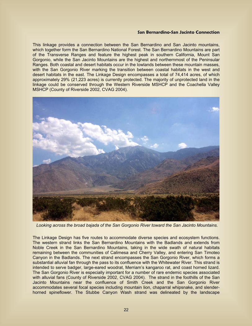
San Bernardino-San Jacinto Connection
This linkage provides a connection between the San Bernardino and San Jacinto mountains, which together form the San Bernardino National Forest. The San Bernardino Mountains are part of the Transverse Ranges and feature the highest peak in southern California, Mount San Gorgonio, while the San Jacinto Mountains are the highest and northernmost of the Peninsular Ranges. Both coastal and desert habitats occur in the lowlands between these mountain masses, with the San Gorgonio River marking the transition between coastal habitats in the west and desert habitats in the east. The Linkage Design encompasses a total of 74,414 acres, of which approximately 29% (21,223 acres) is currently protected. The majority of unprotected land in the linkage could be conserved through the Western Riverside MSHCP and the Coachella Valley MSHCP (County of Riverside 2002, CVAG 2004).
Looking across the broad bajada of the San Gorgonio River toward the San Jacinto Mountains. The Linkage Design has five routes to accommodate diverse species and ecosystem functions. The western strand links the San Bernardino Mountains with the Badlands and extends from Noble Creek in the San Bernardino Mountains, taking in the wide swath of natural habitats remaining between the communities of Calimesa and Cherry Valley, and entering San Timoteo Canyon in the Badlands. The next strand encompasses the San Gorgonio River, which forms a substantial alluvial fan through the pass to its confluence with the Whitewater River. This strand is intended to serve badger, large-eared woodrat, Merriam’s kangaroo rat, and coast horned lizard. The San Gorgonio River is especially important for a number of rare endemic species associated with alluvial fans (County of Riverside 2002, CVAG 2004). The strand in the foothills of the San Jacinto Mountains near the confluence of Smith Creek and the San Gorgonio River accommodates several focal species including mountain lion, chaparral whipsnake, and slender-horned spineflower. The Stubbe Canyon Wash strand was delineated by the landscape
22
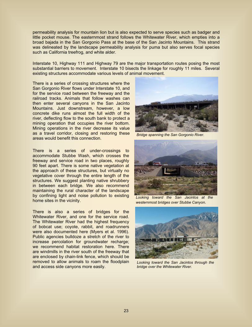
permeability analysis for mountain lion but is also expected to serve species such as badger and little pocket mouse. The easternmost strand follows the Whitewater River, which empties into a broad bajada in the San Gorgonio Pass at the base of the San Jacinto Mountains. This strand was delineated by the landscape permeability analysis for puma but also serves focal species such as California treefrog, and white alder. Interstate 10, Highway 111 and Highway 79 are the major transportation routes posing the most substantial barriers to movement. Interstate 10 bisects the linkage for roughly 11 miles. Several existing structures accommodate various levels of animal movement. There is a series of crossing structures where the San Gorgonio River flows under Interstate 10, and for the service road between the freeway and the railroad tracks. Animals that follow washes can then enter several canyons in the San Jacinto Mountains. Just downstream, however, a low concrete dike runs almost the full width of the river, deflecting flow to the south bank to protect a mining operation that occupies the river bottom. Mining operations in the river decrease its value as a travel corridor, closing and restoring these areas would benefit this connection. There is a series of under-crossings to accommodate Stubbe Wash, which crosses the freeway and service road in two places, roughly 90 feet apart. There is some native vegetation at the approach of these structures, but virtually no vegetative cover through the entire length of the structures. We suggest planting native shrubbery in between each bridge. We also recommend maintaining the rural character of the landscape by confining light and noise pollution to existing home sites in the vicinity. There is also a series of bridges for the Whitewater River, and one for the service road. The Whitewater River had the highest frequency of bobcat use; coyote, rabbit, and roadrunners were also documented here (Myers et al. 1996). Public agencies bulldoze a stretch of the river to increase percolation for groundwater recharge; we recommend habitat restoration here. There are windmills in the river south of the freeway that are enclosed by chain-link fence, which should be removed to allow animals to roam the floodplain and access side canyons more easily.
Bridge spanning the San Gorgonio River.
Looking toward the San Jacintos through the bridge over the Whitewater River.
Looking toward the San Jacintos at the westernmost bridges over Stubbe Canyon.
23

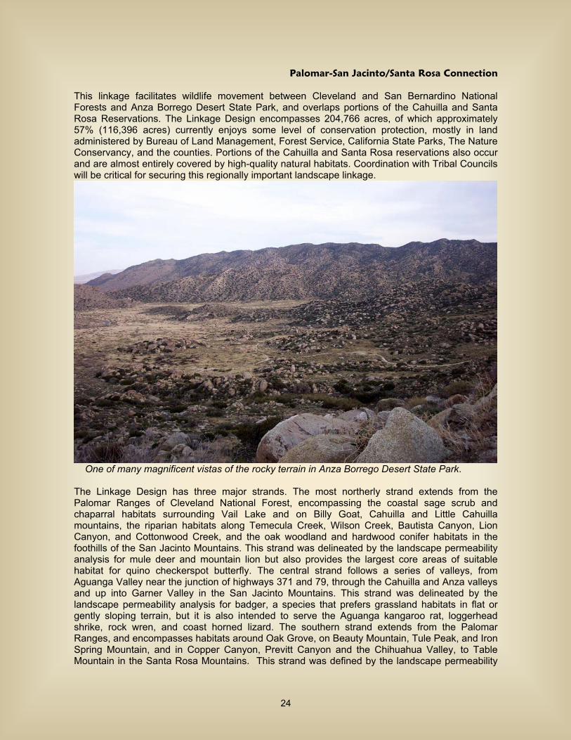
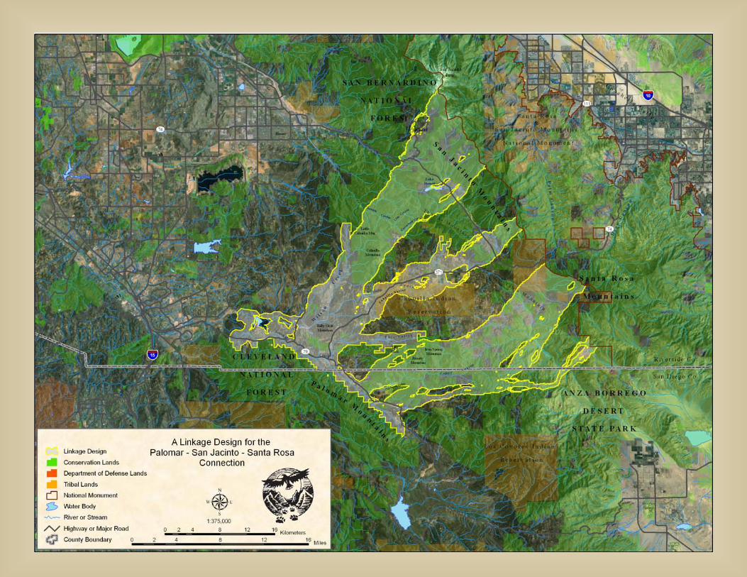
Palomar-San Jacinto/Santa Rosa Connection
This linkage facilitates wildlife movement between Cleveland and San Bernardino National Forests and Anza Borrego Desert State Park, and overlaps portions of the Cahuilla and Santa Rosa Reservations. The Linkage Design encompasses 204,766 acres, of which approximately 57% (116,396 acres) currently enjoys some level of conservation protection, mostly in land administered by Bureau of Land Management, Forest Service, California State Parks, The Nature Conservancy, and the counties. Portions of the Cahuilla and Santa Rosa reservations also occur and are almost entirely covered by high-quality natural habitats. Coordination with Tribal Councils will be critical for securing this regionally important landscape linkage.
One of many magnificent vistas of the rocky terrain in Anza Borrego Desert State Park. The Linkage Design has three major strands. The most northerly strand extends from the Palomar Ranges of Cleveland National Forest, encompassing the coastal sage scrub and chaparral habitats surrounding Vail Lake and on Billy Goat, Cahuilla and Little Cahuilla mountains, the riparian habitats along Temecula Creek, Wilson Creek, Bautista Canyon, Lion Canyon, and Cottonwood Creek, and the oak woodland and hardwood conifer habitats in the foothills of the San Jacinto Mountains. This strand was delineated by the landscape permeability analysis for mule deer and mountain lion but also provides the largest core areas of suitable habitat for quino checkerspot butterfly. The central strand follows a series of valleys, from Aguanga Valley near the junction of highways 371 and 79, through the Cahuilla and Anza valleys and up into Garner Valley in the San Jacinto Mountains. This strand was delineated by the landscape permeability analysis for badger, a species that prefers grassland habitats in flat or gently sloping terrain, but it is also intended to serve the Aguanga kangaroo rat, loggerhead shrike, rock wren, and coast horned lizard. The southern strand extends from the Palomar Ranges, and encompasses habitats around Oak Grove, on Beauty Mountain, Tule Peak, and Iron Spring Mountain, and in Copper Canyon, Previtt Canyon and the Chihuahua Valley, to Table Mountain in the Santa Rosa Mountains. This strand was defined by the landscape permeability
24
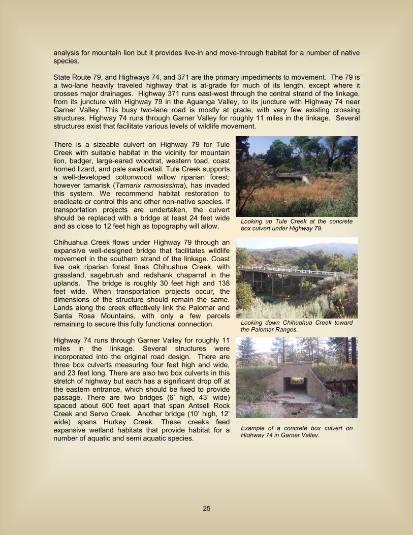
analysis for mountain lion but it provides live-in and move-through habitat for a number of native species. State Route 79, and Highways 74, and 371 are the primary impediments to movement. The 79 is a two-lane heavily traveled highway that is at-grade for much of its length, except where it crosses major drainages. Highway 371 runs east-west through the central strand of the linkage, from its juncture with Highway 79 in the Aguanga Valley, to its juncture with Highway 74 near Garner Valley. This busy two-lane road is mostly at grade, with very few existing crossing structures. Highway 74 runs through Garner Valley for roughly 11 miles in the linkage. Several structures exist that facilitate various levels of wildlife movement. There is a sizeable culvert on Highway 79 for Tule Creek with suitable habitat in the vicinity for mountain lion, badger, large-eared woodrat, western toad, coast horned lizard, and pale swallowtail. Tule Creek supports a well-developed cottonwood willow riparian forest; however tamarisk (Tamarix ramosissima), has invaded this system. We recommend habitat restoration to eradicate or control this and other non-native species. If transportation projects are undertaken, the culvert should be replaced with a bridge at least 24 feet wide and as close to 12 feet high as topography will allow. Chihuahua Creek flows under Highway 79 through an expansive well-designed bridge that facilitates wildlife movement in the southern strand of the linkage. Coast live oak riparian forest lines Chihuahua Creek, with grassland, sagebrush and redshank chaparral in the uplands. The bridge is roughly 30 feet high and 138 feet wide. When transportation projects occur, the dimensions of the structure should remain the same. Lands along the creek effectively link the Palomar and Santa Rosa Mountains, with only a few parcels remaining to secure this fully functional connection. Highway 74 runs through Garner Valley for roughly 11 miles in the linkage. Several structures were incorporated into the original road design. There are three box culverts measuring four feet high and wide, and 23 feet long. There are also two box culverts in this stretch of highway but each has a significant drop off at the eastern entrance, which should be fixed to provide passage. There are two bridges (6’ high, 43’ wide) spaced about 600 feet apart that span Antsell Rock Creek and Servo Creek. Another bridge (10’ high, 12’ wide) spans Hurkey Creek. These creeks feed expansive wetland habitats that provide habitat for a number of aquatic and semi aquatic species.
Looking up Tule Creek at the concrete box culvert under Highway 79.
Looking down Chihuahua Creek toward the Palomar Ranges.
Example of a concrete box culvert on Highway 74 in Garner Valley.
25
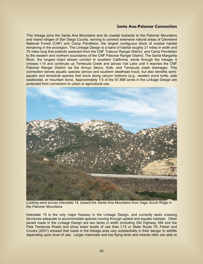
Santa Ana-Palomar Connection
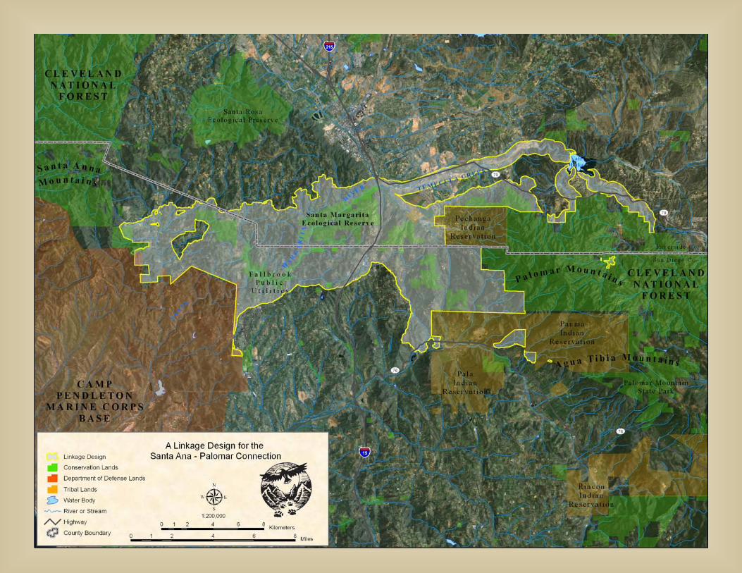
This linkage joins the Santa Ana Mountains and its coastal lowlands to the Palomar Mountains and inland ranges of San Diego County, serving to connect extensive natural areas of Cleveland National Forest (CNF) and Camp Pendleton, the largest contiguous block of coastal habitat remaining in the ecoregion. The Linkage Design is a band of habitat roughly 21 miles in width and 75 miles long that extends eastward from the CNF Trabuco Ranger District, and Camp Pendleton to the western and northern boundaries of the CNF Palomar Ranger District. The Santa Margarita River, the longest intact stream corridor in southern California, winds through the linkage; it crosses I-15 and continues up Temecula Creek and across Vail Lake until it reaches the CNF Palomar Ranger District via the Arroyo Secco, Kolb, and Temecula creek drainages. This connection serves aquatic species (arroyo and southern steelhead trout), but also benefits semi-aquatic and terrestrial species that move along canyon bottoms (e.g., western pond turtle, pale swallowtail, or mountain lions). Approximately 1/3 of the 67,888 acres in the Linkage Design are protected from conversion to urban or agricultural use.
Looking west across Interstate 15, toward the Santa Ana Mountains from Sage Scrub Ridge in the Palomar Mountains. Interstate 15 is the only major freeway in the Linkage Design, and currently lacks crossing structures adequate to accommodate species moving through upland and aquatic habitats. Other paved roads in the Linkage Design are two lanes in width (including Old Highway 394 and the Pala Temecula Road) and show lower levels of use than I-15 or State Route 79. Fisher and Crooks (2001) showed that roads in the linkage area vary substantially in their danger to wildlife depending upon level of use. Larger mammals and low flying birds and insects often are able to
26
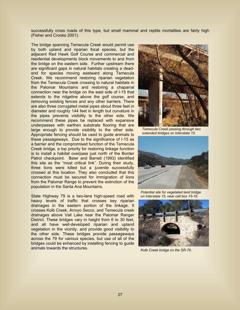
successfully cross roads of this type, but small mammal and reptile mortalities are fairly high (Fisher and Crooks 2001). The bridge spanning Temecula Creek would permit use by both upland and riparian focal species, but the adjacent Red Hawk Golf Course and commercial and residential developments block movements to and from the bridge on the eastern side. Further upstream there are significant gaps in natural habitats creating a dead-end for species moving eastward along Temecula Creek. We recommend restoring riparian vegetation from the Temecula Creek crossing to natural habitats in the Palomar Mountains and restoring a chaparral connection near the bridge on the east side of I-15 that extends to the ridgeline above the golf course, and removing existing fences and any other barriers. There are also three corrugated metal pipes about three feet in diameter and roughly 144 feet in length but curvature in the pipes prevents visibility to the other side. We recommend these pipes be replaced with expansive underpasses with earthen substrate flooring that are large enough to provide visibility to the other side. Appropriate fencing should be used to guide animals to these passageways. Due to the significance of I-15 as a barrier and the compromised function of the Temecula Creek bridge, a top priority for restoring linkage function is to install a habitat overpass just north of the Border Patrol checkpoint. Beier and Barrett (1993) identified this site as the “most critical link”. During their study, three lions were killed but a juvenile successfully crossed at this location. They also concluded that this connection must be secured for immigration of lions from the Palomar Range to prevent the extinction of the population in the Santa Ana Mountains. State Highway 79 is a two-lane high-speed road with heavy levels of traffic that crosses key riparian drainages in the eastern portion of the linkage. It crosses Kolb Creek, Arroyo Secco, and Temecula creek drainages above Vail Lake near the Palomar Ranger District. These bridges vary in height from 6 to 30 feet, and all have well-developed riparian and upland vegetation in the vicinity, and provide good visibility to the other side. These bridges provide passageways across the 79 for various species, but use of all of the bridges could be enhanced by installing fencing to guide animals towards the structures.
Potential site for vegetated land bridge on Interstate 15; near call box 15-16.
Kolb Creek bridge on the SR-79.
Temecula Creek passing through two extended bridges on Interstate 15.
27
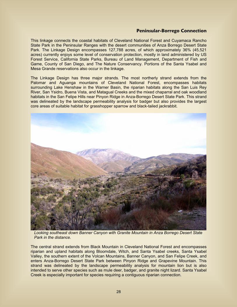
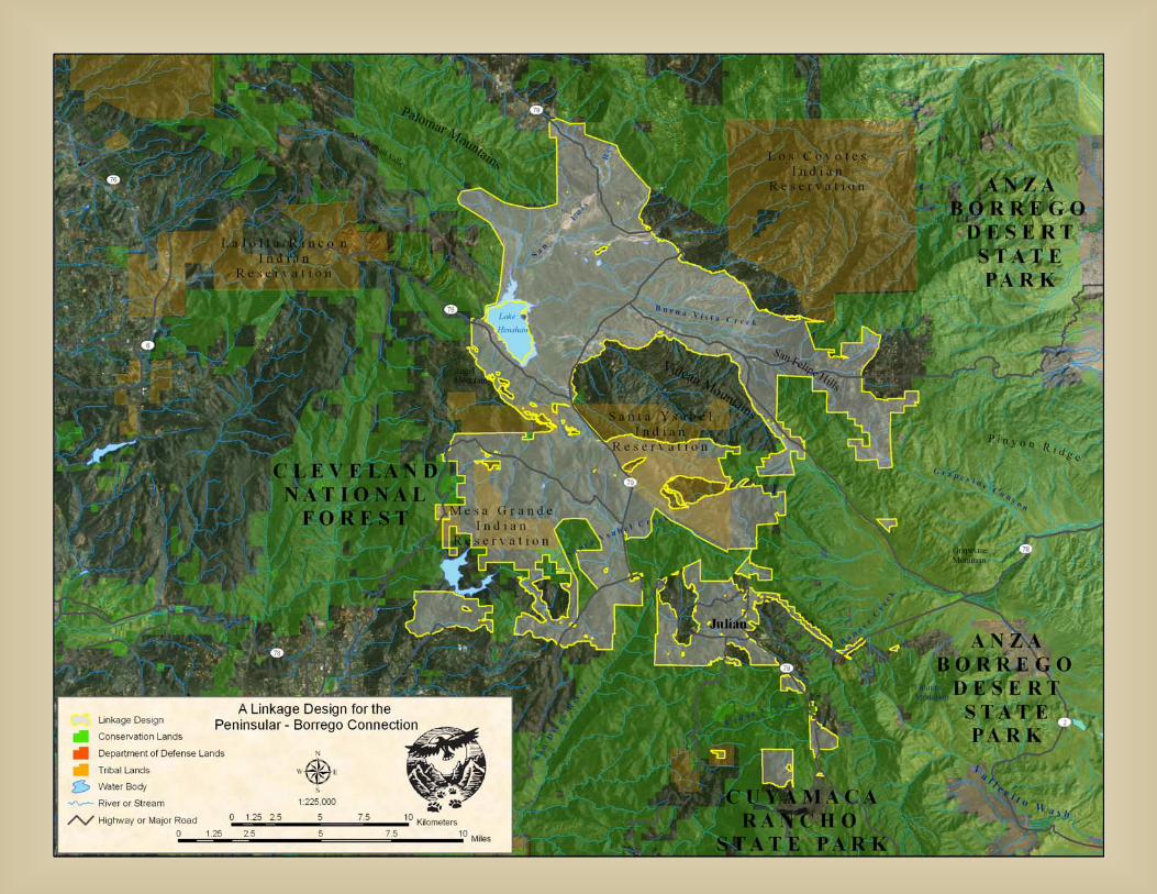
Peninsular-Borrego Connection
This linkage connects the coastal habitats of Cleveland National Forest and Cuyamaca Rancho State Park in the Peninsular Ranges with the desert communities of Anza Borrego Desert State Park. The Linkage Design encompasses 127,788 acres, of which approximately 36% (45,521 acres) currently enjoys some level of conservation protection, mostly in land administered by US Forest Service, California State Parks, Bureau of Land Management, Department of Fish and Game, County of San Diego, and The Nature Conservancy. Portions of the Santa Ysabel and Mesa Grande reservations also occur in the linkage. The Linkage Design has three major strands. The most northerly strand extends from the Palomar and Aguanga mountains of Cleveland National Forest, encompasses habitats surrounding Lake Henshaw in the Warner Basin, the riparian habitats along the San Luis Rey River, San Ysidro, Buena Vista, and Matagual Creeks and the mixed chaparral and oak woodland habitats in the San Felipe Hills near Pinyon Ridge in Anza-Borrego Desert State Park. This strand was delineated by the landscape permeability analysis for badger but also provides the largest core areas of suitable habitat for grasshopper sparrow and black-tailed jackrabbit.
Looking southeast down Banner Canyon with Granite Mountain in Anza Borrego Desert State Park in the distance. The central strand extends from Black Mountain in Cleveland National Forest and encompasses riparian and upland habitats along Bloomdale, Witch, and Santa Ysabel creeks, Santa Ysabel Valley, the southern extent of the Volcan Mountains, Banner Canyon, and San Felipe Creek, and enters Anza-Borrego Desert State Park between Pinyon Ridge and Grapevine Mountain. This strand was delineated by the landscape permeability analysis for mountain lion but is also intended to serve other species such as mule deer, badger, and granite night lizard. Santa Ysabel Creek is especially important for species requiring a contiguous riparian connection.
28

The southern strand extends from Sutherland Lake and follows the belt of oak savanna, and grassland habitats in the Ballena Valley and the riparian habitats of Witch Creek to the upper San Diego River Gorge, and then up Sentenac Creek to habitats around Lake Cuyamaca in Cuyamaca Rancho State Park and the desert riparian habitats of Vallecito Wash in Anza-Borrego Desert State Park. This strand was defined by the landscape permeability analysis for mule deer. State Routes 78 and 79 are the major transportation routes and pose the most substantial barriers to movement. SR-79 bisects the linkage for a distance of roughly 27 miles, while SR-78 passes through the central and southern strands of the linkage. A well-designed bridge conveys flows of Canada Verde Creek under SR-79 near Warner Springs. Coast live oak riparian forest lines the creek with grasslands south of the SR-79 and redshank chaparral the dominant community north of the highway. This bridge is well-suited as a wildlife crossing, as the stream draws animals to the canyon. The Pacific Crest Trail also utilizes this structure, as it passes through the northern strand of the linkage, between Anza-Borrego Desert State Park and Forest Service lands north of SR-79. The least cost corridor for mountain lion crossed SR-79 using Santa Ysabel Creek and researchers have documented lions using the creek as a travel route (Sweanor et al. 2003). There is a well-designed bridge that has natural flooring, provides good visibility, and measures about 30 feet high, 40 feet wide, and 22 feet long. Species that utilize riparian, grassland, or oak savanna habitats (e.g., badger, mule deer, black-tailed jackrabbit, and grasshopper sparrow) will benefit from this connection. Santa Ysabel Creek provides the most direct riparian connection between targeted areas, and most of the canyon is already protected. The bridge for San Felipe Creek is roughly 30 feet high, 325 feet wide and 30 feet long. San Felipe Creek is designated as a National Natural Landmark, one of the last natural perennial desert streams that supports an incredible diversity of species. Many focal species have been detected, including mountain lion, badger, mule deer, black-tailed jackrabbit, granite night lizard, golden eagle, and black brant. Most of the habitat in the San Felipe Hills and Valley is already conserved. S2 runs along San Felipe Creek at the base of the San Felipe Hills, connecting SR-78 and Sr-79. S22 passes through the northern strand of the linkage, and stretches from the community of Borrego Springs to the base of the San Felipe Hills. Both of these scenic highways are currently one lane in each direction and almost entirely at grade. Any road improvements should incorporate regularly spaced culverts to increase movement opportunities for smaller species and reduce roadkill.
Bridge for Santa Ysabel Creek on SR-79.
Bridge for Canada Verde Creek and the PCT under SR-79.
San Felipe Creek flows beneath SR-78 through a bridge that provides passage to numerous species.
29
Missing Linkages along the U.S.-México Border
Linkages along the U.S.-México border in San Diego and Imperial counties are being implemented as part of the Las Californias Binational Conservation Initiative (LCBCI; www.consbio.org/cbi/projects), led by The Nature Conservancy, Conservation Biology Institute, Pronatura, and Terra Peninsular, with assistance from the Resources Legacy Fund Foundation, Back Country Land Trust, The Conservation Fund, California State Parks, Bureau of Land Management, and others. As a result of the LCBCI, priority properties have been identified and approximately 3,500 acres have been conserved to date (representing an investment of over $8 million in private, state, and federal funds), and LCBCI priorities have been included in several agency planning documents. The California Biodiversity Council (CBC) has embraced LCBCI and established a border work group, comprised of agencies and NGOs from both sides of the border, which is collaborating on implementation. We are also working with the San Diego Natural History Museum, U.S. and Mexican agencies, and academic institutions on a binational expedition to increase our understanding of resources in the study area on both sides of the border. Otay Mountain─Cerro San Ysidro linkage Otay Mountain in California and Cerro San Ysidro in Baja California represent sky islands of endemic plant species and represent the last cross-border coastal sage scrub linkage. This linkage continues along Cottonwood Creek to the Laguna Mountains in the Cleveland National Forest. Completion of this linkage will contribute to the recovery of 22 federally and state listed species and secure protection of some of the most rare and floristically diverse vegetation communities on the planet. La Posta linkage This linkage serves to connect the Campo Valley in San Diego County with the El Hongo Valley in Baja California. It occurs in an ecological transition area between the coast and the desert, and between mountain and inland valley biomes. Completing this linkage, by conserving a series of small core areas, will decrease fragmentation, maintain a sanctuary of wilderness values at the edge of an urban metropolis, and ensure conservation across a range of elevational gradients that will enhance the resilience of existing protected lands to global climate change. Parque-to-Park linkage This linkage provides a connection between Anza-Borrego Desert State Park in San Diego and Imperial counties, and Parque Constitución de 1857 in Baja California. This is a truly continental-scale linkage along the transboundary region of the Peninsular Ranges, thus ensuring cross-border connectivity through the eastern edge of the South Coast Ecoregion and the Sonoran Desert. Completing this linkage ultimately will allow the endangered Peninsular Bighorn Sheep to repopulate the Sierra Juárez in northern Baja California and encourage binational collaboration in managing bighorn sheep populations on both sides of the border. Following are a few of the primary implementation objectives:
Work toward creation of a binational park that links Parque Constitución de 1857 in the Sierra Juárez in Baja California with public wilderness areas in San Diego County.
Work toward creation of a cross-border linkage between Tijuana and Tecate / San Diego and Campo.
Conserve the Cottonwood Creek corridor between Cerro San Ysidro, Otay Mountain, and the Laguna Mountains.
Provide technical support to Mexican partners in conserving large, intact natural areas and working landscapes within Baja California.
30
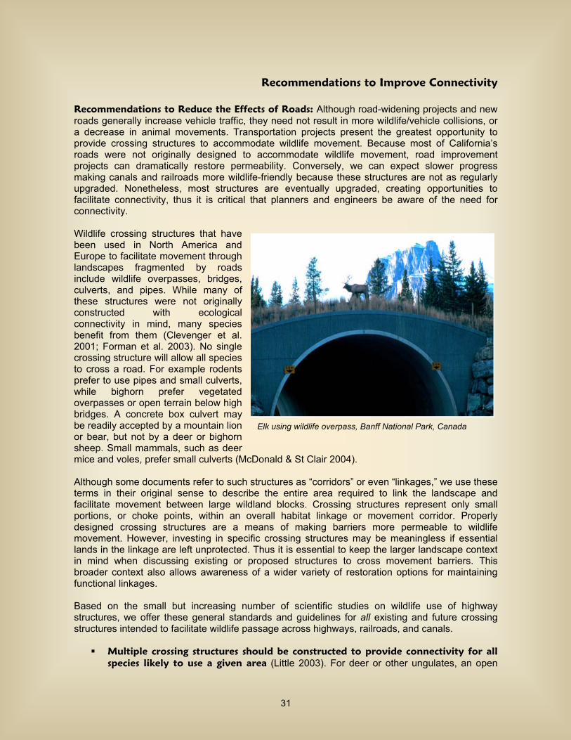
Recommendations to Improve Connectivity Recommendations to Reduce the Effects of Roads: Although road-widening projects and new roads generally increase vehicle traffic, they need not result in more wildlife/vehicle collisions, or a decrease in animal movements. Transportation projects present the greatest opportunity to provide crossing structures to accommodate wildlife movement. Because most of California’s roads were not originally designed to accommodate wildlife movement, road improvement projects can dramatically restore permeability. Conversely, we can expect slower progress making canals and railroads more wildlife-friendly because these structures are not as regularly upgraded. Nonetheless, most structures are eventually upgraded, creating opportunities to facilitate connectivity, thus it is critical that planners and engineers be aware of the need for connectivity. Wildlife crossing structures that have been used in North America and Europe to facilitate movement through landscapes fragmented by roads include wildlife overpasses, bridges, culverts, and pipes. While many of these structures were not originally constructed with ecological connectivity in mind, many species benefit from them (Clevenger et al. 2001; Forman et al. 2003). No single crossing structure will allow all species to cross a road. For example rodents prefer to use pipes and small culverts, while bighorn prefer vegetated overpasses or open terrain below high bridges. A concrete box culvert may be readily accepted by a mountain lion or bear, but not by a deer or bighorn sheep. Small mammals, such as deer mice and voles, prefer small culverts (McDonald & St Clair 2004). Although some documents refer to such structures as “corridors” or even “linkages,” we use these terms in their original sense to describe the entire area required to link the landscape and facilitate movement between large wildland blocks. Crossing structures represent only small portions, or choke points, within an overall habitat linkage or movement corridor. Properly designed crossing structures are a means of making barriers more permeable to wildlife movement. However, investing in specific crossing structures may be meaningless if essential lands in the linkage are left unprotected. Thus it is essential to keep the larger landscape context in mind when discussing existing or proposed structures to cross movement barriers. This broader context also allows awareness of a wider variety of restoration options for maintaining functional linkages. Based on the small but increasing number of scientific studies on wildlife use of highway structures, we offer these general standards and guidelines for all existing and future crossing structures intended to facilitate wildlife passage across highways, railroads, and canals.
Multiple crossing structures should be constructed to provide connectivity for all species likely to use a given area (Little 2003). For deer or other ungulates, an open
Elk using wildlife overpass, Banff National Park, Canada
31
structure such as a bridge is crucial. For medium-sized mammals, black bear, and mountain lions, large box culverts with natural earthen substrate flooring are optimal (Evink 2002). For small mammals, pipe culverts from 0.3m – 1 m in diameter are preferable (Clevenger et al. 2001; McDonald & St Clair 2004).
At least one crossing structure should be located within an individual’s home
range. Because most reptiles, small mammals, and amphibians have small home ranges, metal or cement box culverts should be installed at intervals of 150-300 m (Clevenger et al. 2001). For ungulates (deer, bighorn) and large carnivores, larger crossing structures such as bridges, viaducts, or overpasses should be located no more than 1.5 km (0.94 miles) apart (Mata et al. 2005; Clevenger and Wierzchowski 2006).
Suitable habitat for species should occur on both sides of the structure (Ruediger
2001; Barnum 2003; Cain et al. 2003; Ng et al. 2004). “Crossing structures will only be as effective as the land and resource management strategies around them” (Clevenger et al. 2005).
Whenever possible, suitable habitat should occur within the crossing structure.
This can best be achieved by having a bridge high enough to allow enough light for vegetation to grow under the bridge, and by making sure that the bridge spans upland habitat that is not regularly scoured by floods. Where this is not possible, rows of stumps or strands under large span bridges can provide cover for smaller animals such as reptiles, amphibians, rodents, and invertebrates; regular visits are needed to replace artificial cover removed by flood. Within culverts, earthen floors are preferred by mammals and reptiles.
Structures should be monitored for, and cleared of, obstructions that impede
movement. Many box culverts have large accumulations of branches, Russian thistle, sand, or garbage that impede animal movement, while bridged undercrossings rarely have these problems.
Fencing should direct animals towards crossing structures (Yanes et al. 1995). In
Florida, construction of a wall to guide animals into a culvert system resulted in 93.5% reduction in roadkill, and also increased the total number of species using the culvert from 28 to 42 (Dodd et al. 2004). One-way ramps on roadside fencing can allow an animal to escape if it is trapped on a road (Forman et al. 2003).
Raised sections of road discourage animals from crossing roads, and should be
used when possible to encourage animals to use crossing structures. Clevenger et al. (2003) found that vertebrates were 93% less susceptible to road-kills on sections of road raised on embankments, compared to road segments at the natural grade of the surrounding terrain.
Manage human activity near each crossing structure. Clevenger & Waltho (2000)
suggest that human use of crossing structures should be restricted and foot trails relocated away from structures intended for wildlife movement. However, a large crossing structure (viaduct or long, high bridge) should be able to accommodate both recreational and wildlife use. At a minimum, nighttime human use of crossing structures should be restricted.
Design culverts specifically to provide for animal movement. Most culverts are
designed to carry water under a road and minimize erosion hazard to the road. Culvert designs adequate for transporting water often have pour-offs at the downstream ends that
32
prevent wildlife usage. At least one culvert every 150-300m of road should have openings flush with the surrounding terrain, and with native land cover up to both culvert openings, as noted above.
Recommendations to Reduce the Effects of Rail Lines: We recommend a policy of using any railroad realignment as an opportunity not simply to mitigate loss of wildland connectivity, but to improve it. Ameliorating the adverse affects of railroads is similar to that for roads, providing viaducts, bridged underpasses, and tunnels (Reed and Schwarzmeier 1978, Borowske and Heitlinger 1981, Forman 1995).
We recommend that crossing structures should be sited at least every 1.5 to 2 km. We suggest structures for rail lines be aligned with crossing structures on freeways.
We encourage crossing structures associated with rail lines be integrated with sound
walls to reduce noise.
Structures should be integrated with fences where beneficial to guide animals toward crossing structures. Fencing can be permeable to humans and larger animals, and would not be needed where steep cut and fill slopes already divert animals toward structures.
Recommendations to Reduce the Effects of Streams Barriers: Since 80% of terrestrial vertebrate species depend on riparian systems (Kreuper 1992), it is critical to maintain these communities. Measures to minimize development impacts on aquatic habitats typically focus on establishing riparian buffer zones (Barton et al. 1985, Allan 1995, Willson and Dorcas 2003). Buffers must contain enough upland habitat to maintain water-quality and habitat characteristics essential to the survival of many aquatic and semiaquatic organisms (Brosofske et al.1997, Willson and Dorcas 2003). To enhance species use of riparian habitats, we recommend:
Restore riparian vegetation in all drainages and upland vegetation within 0.6 miles of streams and rivers to encourage plant and animal movement and increase water quality.
Investigate historic flow regimes and develop surface and groundwater management
programs to restore and recover properly functioning aquatic/riparian conditions. Remove exotic plants (e.g., tamarisk) and animals (e.g., bullfrogs, African clawed frogs)
from washes, streams and rivers. Work with relevant agencies and organizations to survey for invasive species and develop a comprehensive removal strategy.
Enforce regulations protecting streams and stream vegetation from illegal diversion,
alteration, manure dumping, and vegetation removal. Enforce regulations restricting farming, gravel mining, suction dredging, and building in
streams and floodplains. Work with the Resource Conservation Districts to help establish use of Best Management
Practices for rural communities in the linkage designs and surrounding communities. Support efficient water use and education programs that promote water conservation.
Discourage development in flood prone areas and prevent the construction of concrete-
banked streams and other channelization projects.
33
Support the protection of riparian and adjacent upland habitats on private lands. Pursue cooperative programs to improve conditions in riparian and upland habitats.
Recommendations to Reduce the Effects of Mining: Mining operations can be modified with actions that reduce the affects of these industrial activities. Preventing any further mining operations in key areas of a Linkage Design through administrative withdrawals will have the greatest effect on preserving linkage function. Existing mining operations can be targeted for regulatory actions that reduce the effects of these industrial activities. These include, limiting noise from blasting, minimizing night lighting, reducing traffic in sensitive areas or constriction points, monitoring water quality and quantity, minimizing the use of harmful chemicals, and increasing enforcement of existing regulations. The California Surface Mining and Reclamation Act (1975) require that land used in mining operations be restored once operations have ceased. Recommendations to Reduce the Effects of Urban Barriers: Urban developments, unlike roads, create movement barriers that cannot be readily removed, restored, or mitigated. Preventing urban developments in key areas through acquisition or conservation easements is therefore the strongest option. Mitigation for existing urban developments focuses on designing and managing buffers to reduce penetration of undesirable effects into natural areas (Marzluff and Ewing 2001). Management in buffers can include fencing in pets, reducing human traffic in sensitive areas or constriction points, limiting noise and lighting, reducing traffic speeds, minimizing use of irrigation, maximizing outdoor water use efficiency measures, encouraging the planting of locally native vegetation, minimizing the use of pesticides, poisons and other harmful chemicals, and increasing enforcement of existing regulations. Recommendations to Reduce the Effect of Agricultural Barriers: Agricultural practices remove native vegetation, require significant water resources, and increase nutrient runoff into streams, and support invasions by exotic species. Waters draining from these developments show elevated levels of nutrients and particles. Many drainages that were once ephemeral become perennial (Fisher and Crooks 2001) and are capable of supporting exotic species such as exotic fish, bullfrogs and giant reed. As with urban developments, acquisition or conservation easements with willing landowners will have the greatest effect on preserving linkage function from agricultural impacts. For existing developments, a variety of Best Management Practices can reduce nutrient runoff and erosion. These include the timing and types of nutrient use, use of native vegetation to absorb surface and subsurface runoff, dirt road design, and soil management. In addition, the pattern of agricultural developments can have a significant affect on species movements. We provide the following initial recommendations to prevent or mitigate the effects of agriculture in the linkage design areas:
Discourage further agricultural development by purchasing lands with natural vegetation, or developing easements with willing landowners.
Restore agricultural lands in areas of a linkage where natural habitats have been severely
constricted. Where possible, restore a one kilometer wide isthmus of habitat through adjacent agricultural developments.
Work with The Regional Water Quality Control Board’s Total Maximum Daily Load plans
to evaluate the cause the water quality deterioration and enact an implementation plan to return water quality to targeted water quality values.
Encourage research on agriculture that specifically identifies solutions to elevated nutrient
runoff, erosion, and effects of perennializing streams.
34
Recommendations to Reduce the Effects of Recreation: If recreational activities are effectively planned, developed, managed, and monitored, most negative impacts can be avoided or minimized by limiting types of use, directing recreational activities away from particular locations, sometimes only for particular seasons, and with reasonable precautions. We provide the following recommendations:
Monitor recreational use to provide a baseline for decisions regarding levels, types, and timing of recreational use.
Collect data on special status species, species movements, and vegetation disturbance in
areas of high recreational activity. Develop and conduct multi-lingual outreach programs to recreational users on how to
lessen impacts in sensitive areas. Close, obliterate, and restore any unauthorized off-road vehicle routes.
Enforce leash laws so that dogs are under restraint at all times.
35
Translating Plans into Action Although South Coast Missing Linkages rigorous, detailed designs are central to the approach, the project will not be complete with the publication of the linkage designs. The success of South Coast Missing Linkage will be measured by our effectiveness at translating our vision of a connected landscape into land-saving actions. With the completion of the planning and design phase comes the need to disseminate and institutionalize the results and build and support Linkage Implementation Coalitions to undertake the on-the-ground work to conserve our South Coast linkages. Institutionalization of Linkage Designs Partners in the South Coast Missing Linkages initiative are designing a strategic outreach plan that will a) focus broad incorporation of the Linkage Designs into relevant governing instruments (e.g. general plans, HCPs, local ordinances, CEQA); b) establish a public expectation of linkage protection; c) organize new constituencies and empower old partners; and d) utilize the unique abilities of each constituency to institutionalize support for these linkages. We are also working with our partners to develop and implement communication strategies to broaden the dissemination of the designs and inform the public and decision makers as to the importance of protecting these linkages. The South Coast Missing Linkages initiative has already strongly influenced a number of important local, regional, and statewide conservation planning efforts. One direct result of our broad collaboration is the integration of the South Coast Missing Linkages into policy decisions to improve and enforce protection of these regionally important habitat linkages. For example, the four southern California Forests (Los Padres, Angeles, San Bernardino, and Cleveland) recently finalized their Resource Management Plans and identified connecting the four forests to the existing network of protected lands as one of the key strategies for protecting biodiversity in the forests. South Coast Missing Linkages was also recently acknowledged as a vital strategy for improving the status of wildlife in the state by the California Department of Fish and Game in a report prepared for the National State Wildlife Grant Program. California Wildlife: Conservation Challenges includes the following as one of its Recommended Region-Specific Conservation Actions:
“To address regional habitat fragmentation, federal, state, and local agencies, along with nongovernmental conservation organizations, should support the protection of the priority wildland linkages identified by the South Coast Missing Linkages project.”
South Coast Wildlands is representing South Coast Missing Linkages in the Western Governors Wildlife Corridors Initiative (http://www.we stgov.org/wga/initiatives/corridors/index.htm). The governors of the 19 Western States passed a unanimous resolution in 2007 that all future highways, canals, energy developments, and new land-use plans should be consistent with conservation of important wildlife corridors. Although this will be a broad-brush approach, it can profoundly impact the face of the conserved landscape of the Western United States. Building Implementation Coalitions The importance of investing in building and maintaining relationships cannot be over-emphasized. Development of technical plans to overcome barriers to animal movement must be matched by efforts to build and maintain linkages among all the players. Partners across the region have already heeded the call to action! The following describes a few of the implementation activities underway to translate our plans into land-saving actions:
36
In the Santa Ana-Palomar Mountains Linkage, we have been working with the South Coast Conservation Forum, a consortium of county, state, and federal agencies, universities, and non profits formed to advise the Department of Defense on reducing urban encroachment and conflicts with military training maneuvers on Camp Pendleton. South Coast Missing Linkages information provided to the Forum ensured that this linkage was recognized as important to mitigating long-term impacts to sensitive species. The Linkage Design has been used to target Defense Authorization Act funds that will protect thousands of acres within the linkage. In addition, this linkage overlaps planning boundaries for two Multiple Species Conservation Plans, the Western Riverside Multiple Species Habitat Conservation Plan and the Northern San Diego Multiple Species Conservation Plan. Roughly 70% of the linkage in Riverside County and 92% in San Diego County are targeted for conservation by these NCCPs. A Conceptual Area Protection Plan (CAPP) has also been completed which will target state land acquisition funds. To conserve the linkage between the San Gabriel Mountains and the Castaic Ranges of the Angeles National Forest, we are partnering with Upper Santa Clara Biodiversity Working Group, whose members include Forest Service, Bureau of Land Management, Fish and Wildlife Service, Department of Fish & Game, City of Santa Clarita, Santa Monica Mountains Conservancy (SMMC), Rivers and Mountains Conservancy, Wetlands Recovery Project, and The Nature Conservancy (TNC). The Linkage Design helped the agencies focus on the western part of the linkage; the most important area for promoting wildlife movement. The City of Santa Clarita is focusing its capital improvement project mitigation acquisitions in the Linkage Design even though this area is outside their city limits. The Forest Service is working with National Park Service to reroute the Pacific Crest Trail, now threatened by encroaching development, into our linkage design. A CAPP has also been completed, which will target state land acquisition funds. The Nature Conservancy, Rivers and Mountains Conservancy, & Santa Monica Mountains Conservancy are working with the Land Agent at Wildlife Conservation Board to acquire land in the linkage. To maintain connectivity between the Santa Monica Mountains and Sierra Madre Ranges, we are working with the National Park Service, Caltrans, SMMC, TNC, Trust for Public Land, and Los Angeles and Ventura Counties. Caltrans used the Linkage Design to identify mitigation opportunities along State Route 118, and has initiated a working group for this transportation improvement project. It is our hope that this working group will evolve into an implementation coalition that covers the entire linkage area. Exporting the South Coast Missing Linkages Model The success with which South Coast Missing Linkages has been met propels us to work with our partners beyond the South Coast Ecoregion to identify and design landscape linkages across the state, the west, and the nation. To our great excitement, the state of Arizona has completely adopted the South Coast Missing Linkages methodology for designing landscape linkages, and Colorado has partially adopted it. The Vision The ecological, educational, recreational, and spiritual values of protected wildlands in the South Coast Ecoregion are immense. These conserved lands also represent an investment of tens of billions of dollars. We need to ensure the ecological health of this investment by securing these linkages. These Linkage Designs represent opportunities to protect truly functional landscape-level connections among these wildlands. If implemented, our plan would not only permit movement of individuals and genes, but should also conserve large-scale ecosystem processes that are essential to the integrity of existing conservation investments throughout the region.
37
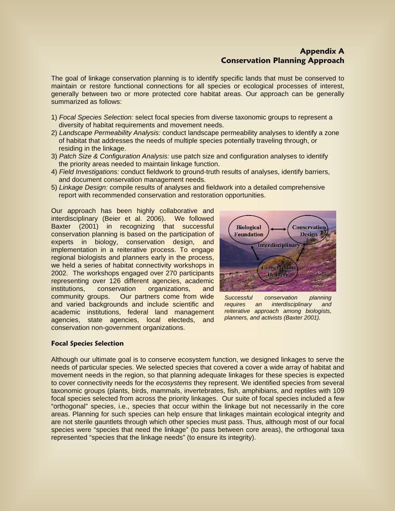
Appendix A Conservation Planning Approach
The goal of linkage conservation planning is to identify specific lands that must be conserved to maintain or restore functional connections for all species or ecological processes of interest, generally between two or more protected core habitat areas. Our approach can be generally summarized as follows: 1) Focal Species Selection: select focal species from diverse taxonomic groups to represent a diversity of habitat requirements and movement needs. 2) Landscape Permeability Analysis: conduct landscape permeability analyses to identify a zone of habitat that addresses the needs of multiple species potentially traveling through, or residing in the linkage. 3) Patch Size & Configuration Analysis: use patch size and configuration analyses to identify the priority areas needed to maintain linkage function. 4) Field Investigations: conduct fieldwork to ground-truth results of analyses, identify barriers, and document conservation management needs. 5) Linkage Design: compile results of analyses and fieldwork into a detailed comprehensive report with recommended conservation and restoration opportunities. Our approach has been highly collaborative and interdisciplinary (Beier et al. 2006). We followed Baxter (2001) in recognizing that successful conservation planning is based on the participation of experts in biology, conservation design, and implementation in a reiterative process. To engage regional biologists and planners early in the process, we held a series of habitat connectivity workshops in 2002. The workshops engaged over 270 participants representing over 126 different agencies, academic institutions, conservation organizations, and community groups. Our partners come from wide and varied backgrounds and include scientific and academic institutions, federal land management agencies, state agencies, local electeds, and conservation non-government organizations. Focal Species Selection Although our ultimate goal is to conserve ecosystem function, we designed linkages to serve the needs of particular species. We selected species that covered a cover a wide array of habitat and movement needs in the region, so that planning adequate linkages for these species is expected to cover connectivity needs for the ecosystems they represent. We identified species from several taxonomic groups (plants, birds, mammals, invertebrates, fish, amphibians, and reptiles with 109 focal species selected from across the priority linkages. Our suite of focal species included a few “orthogonal” species, i.e., species that occur within the linkage but not necessarily in the core areas. Planning for such species can help ensure that linkages maintain ecological integrity and are not sterile gauntlets through which other species must pass. Thus, although most of our focal species were “species that need the linkage” (to pass between core areas), the orthogonal taxa represented “species that the linkage needs” (to ensure its integrity).
Successful conservation planning requires an interdisciplinary and reiterative approach among biologists, planners, and activists (Baxter 2001).
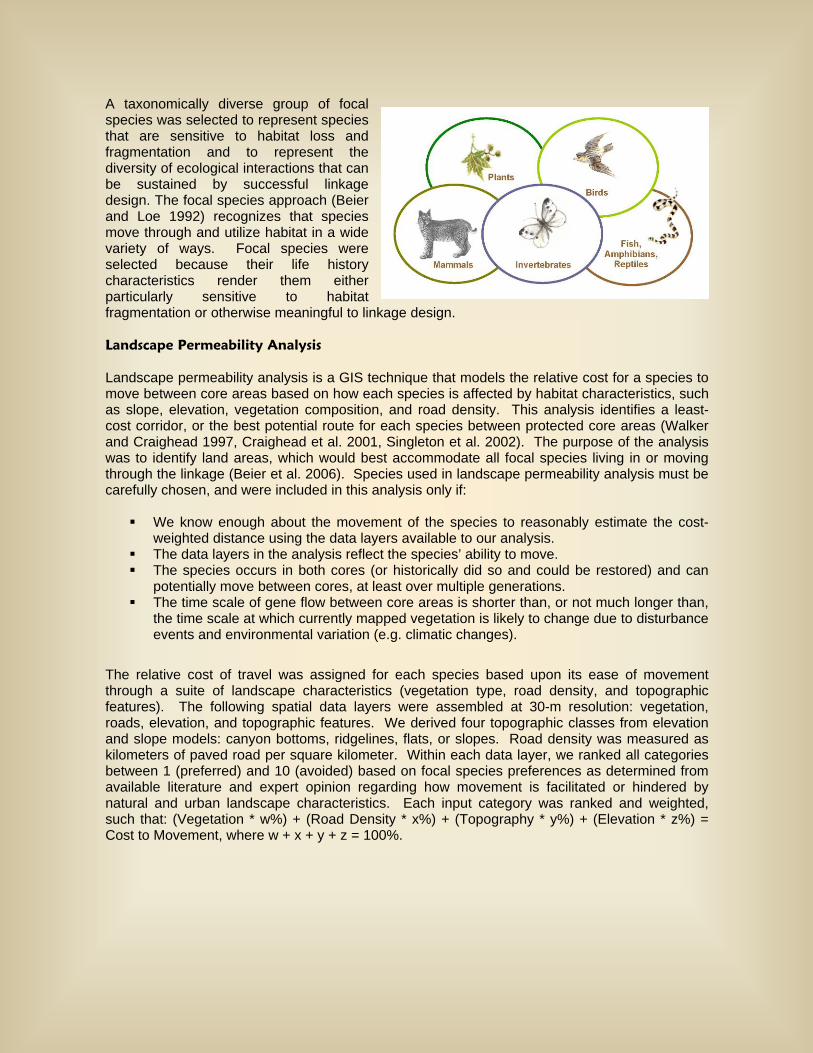
A taxonomically diverse group of focal species was selected to represent species that are sensitive to habitat loss and fragmentation and to represent the diversity of ecological interactions that can be sustained by successful linkage design. The focal species approach (Beier and Loe 1992) recognizes that species move through and utilize habitat in a wide variety of ways. Focal species were selected because their life history characteristics render them either particularly sensitive to habitat fragmentation or otherwise meaningful to linkage design. Landscape Permeability Analysis Landscape permeability analysis is a GIS technique that models the relative cost for a species to move between core areas based on how each species is affected by habitat characteristics, such as slope, elevation, vegetation composition, and road density. This analysis identifies a least-cost corridor, or the best potential route for each species between protected core areas (Walker and Craighead 1997, Craighead et al. 2001, Singleton et al. 2002). The purpose of the analysis was to identify land areas, which would best accommodate all focal species living in or moving through the linkage (Beier et al. 2006). Species used in landscape permeability analysis must be carefully chosen, and were included in this analysis only if:
We know enough about the movement of the species to reasonably estimate the cost-weighted distance using the data layers available to our analysis.
The data layers in the analysis reflect the species’ ability to move. The species occurs in both cores (or historically did so and could be restored) and can
potentially move between cores, at least over multiple generations. The time scale of gene flow between core areas is shorter than, or not much longer than,
the time scale at which currently mapped vegetation is likely to change due to disturbance events and environmental variation (e.g. climatic changes).
The relative cost of travel was assigned for each species based upon its ease of movement through a suite of landscape characteristics (vegetation type, road density, and topographic features). The following spatial data layers were assembled at 30-m resolution: vegetation, roads, elevation, and topographic features. We derived four topographic classes from elevation and slope models: canyon bottoms, ridgelines, flats, or slopes. Road density was measured as kilometers of paved road per square kilometer. Within each data layer, we ranked all categories between 1 (preferred) and 10 (avoided) based on focal species preferences as determined from available literature and expert opinion regarding how movement is facilitated or hindered by natural and urban landscape characteristics. Each input category was ranked and weighted, such that: (Vegetation * w%) + (Road Density * x%) + (Topography * y%) + (Elevation * z%) = Cost to Movement, where w + x + y + z = 100%.

Weighting allowed the model to capture variation in the influence of each input (vegetation, road density, topography, elevation) on focal species movements. A unique cost surface was thus developed for each species. A corridor function was then performed in GIS to generate a data layer showing the relative degree of permeability between core areas. For each focal species, the most permeable area of the study window was designated as the least-cost corridor. The least-cost corridor output for all focal species was then combined to generate a Least Cost Union. The biological significance of this Union can best be described as the zone within which all modeled species would encounter the least energy expenditure (i.e., preferred travel route) and the most favorable habitat as they move between targeted protected areas. The output does not identify barriers (which were later identified through fieldwork), mortality risks, dispersal limitations or other biologically significant processes that could prevent a species from successfully reaching a core area. Rather, it identifies the best zone available for focal species movement based on the data layers used in the analyses. Patch Size & Configuration Analysis Although the Least-Cost Union identifies the best zone available for movement based on the data layers used in the analyses, it does not address whether suitable habitat in the Union occurs in large enough patches to support viable populations and whether these patches are close enough together to allow for inter-patch dispersal. We therefore conducted patch size and configuration analyses for all focal species (Table 1) and adjusted the boundaries of the Least Cost Union where necessary to enhance the likelihood of movement. Patch size and configuration analyses are particularly important for species that require multiple generations to traverse the linkage. Many species exhibit metapopulation dynamics, whereby the long-term persistence of a local population requires connection to other populations (Hanski and Gilpin 1991). For relatively sedentary species like desert woodrat and terrestrial insects, gene flow will occur over decades through a metapopulation. Thus, the linkage must be able to accommodate metapopulation dynamics to support ecological and evolutionary processes in the long term.
A habitat suitability model formed the basis of the patch size and configuration analyses. Habitat suitability models were developed for each focal species using the literature and expert opinion. Spatial data layers used in the analysis varied by species and included: vegetation, elevation, topographic features, slope, aspect, hydrography, and soils. Using scoring and weighting
Permeability Model Inputs: elevation, vegetation, topography, and road density. Landscape permeability analysis models the relative cost for a species to move between core areas based on how each species is affected by various habitat characteristics.
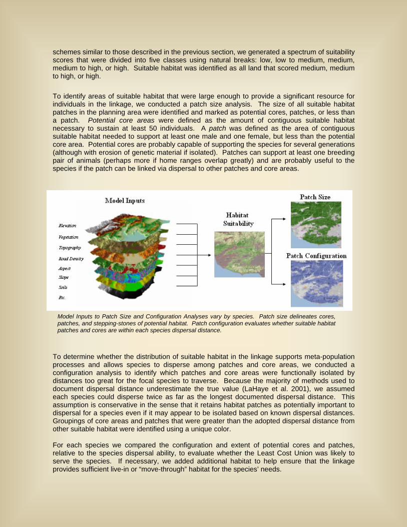
schemes similar to those described in the previous section, we generated a spectrum of suitability scores that were divided into five classes using natural breaks: low, low to medium, medium, medium to high, or high. Suitable habitat was identified as all land that scored medium, medium to high, or high.
To identify areas of suitable habitat that were large enough to provide a significant resource for individuals in the linkage, we conducted a patch size analysis. The size of all suitable habitat patches in the planning area were identified and marked as potential cores, patches, or less than a patch. Potential core areas were defined as the amount of contiguous suitable habitat necessary to sustain at least 50 individuals. A patch was defined as the area of contiguous suitable habitat needed to support at least one male and one female, but less than the potential core area. Potential cores are probably capable of supporting the species for several generations (although with erosion of genetic material if isolated). Patches can support at least one breeding pair of animals (perhaps more if home ranges overlap greatly) and are probably useful to the species if the patch can be linked via dispersal to other patches and core areas.
To determine whether the distribution of suitable habitat in the linkage supports meta-population processes and allows species to disperse among patches and core areas, we conducted a configuration analysis to identify which patches and core areas were functionally isolated by distances too great for the focal species to traverse. Because the majority of methods used to document dispersal distance underestimate the true value (LaHaye et al. 2001), we assumed each species could disperse twice as far as the longest documented dispersal distance. This assumption is conservative in the sense that it retains habitat patches as potentially important to dispersal for a species even if it may appear to be isolated based on known dispersal distances. Groupings of core areas and patches that were greater than the adopted dispersal distance from other suitable habitat were identified using a unique color. For each species we compared the configuration and extent of potential cores and patches, relative to the species dispersal ability, to evaluate whether the Least Cost Union was likely to serve the species. If necessary, we added additional habitat to help ensure that the linkage provides sufficient live-in or “move-through” habitat for the species’ needs.
Model Inputs to Patch Size and Configuration Analyses vary by species. Patch size delineates cores, patches, and stepping-stones of potential habitat. Patch configuration evaluates whether suitable habitat patches and cores are within each species dispersal distance.

Minimum Linkage Width While the size and distance among habitats (addressed by patch size and configuration analyses) must be adequate to support species movement, the shape of those habitats also plays a key role. In particular, constriction points—areas where habitats have been narrowed by surrounding development—can prevent organisms from moving through the Least Cost Union. To ensure that functional processes are protected, we imposed a minimum width of 2 km (1.2 mi) for all portions of the final Linkage Design. For a variety of species, including those we did not formally model, a wide linkage helps ensure availability of appropriate habitat, host plants (e.g., for butterflies), pollinators, and areas with low predation risk. In addition, fires and floods are part of the natural disturbance regime and a wide linkage allows for a semblance of these natural disturbances to operate with minimal constraints from adjacent urban areas. A wide linkage should also enhance the ability of the biota to respond to climate change, and buffer against edge effects. Field Investigations We conducted field surveys to ground-truth habitat conditions, document existing barriers and potential passageways, and determine restoration opportunities. Because paved roads present the most formidable barriers, surveyors drove or walked each accessible section of road that transected a linkage. We identified areas where structures could be improved or installed, and opportunities to restore vegetation to improve road crossings and minimize roadkills. Restoration and Conservation Opportunities and Recommendations Each Linkage Design provides implementation opportunities for agencies, organizations, and individuals interested in participating in conservation activities in the linkage. Biological and land use summaries include descriptions and maps of vegetation, land cover, land use, roads, road crossings, railroads, and restoration opportunities. Each design also identifies existing planning efforts addressing the conservation and use of natural resources in the planning area. Finally, each provides a flyover animation using aerial imagery, satellite imagery, and digital elevations models, which provide a visualization of the linkage from a landscape perspective.
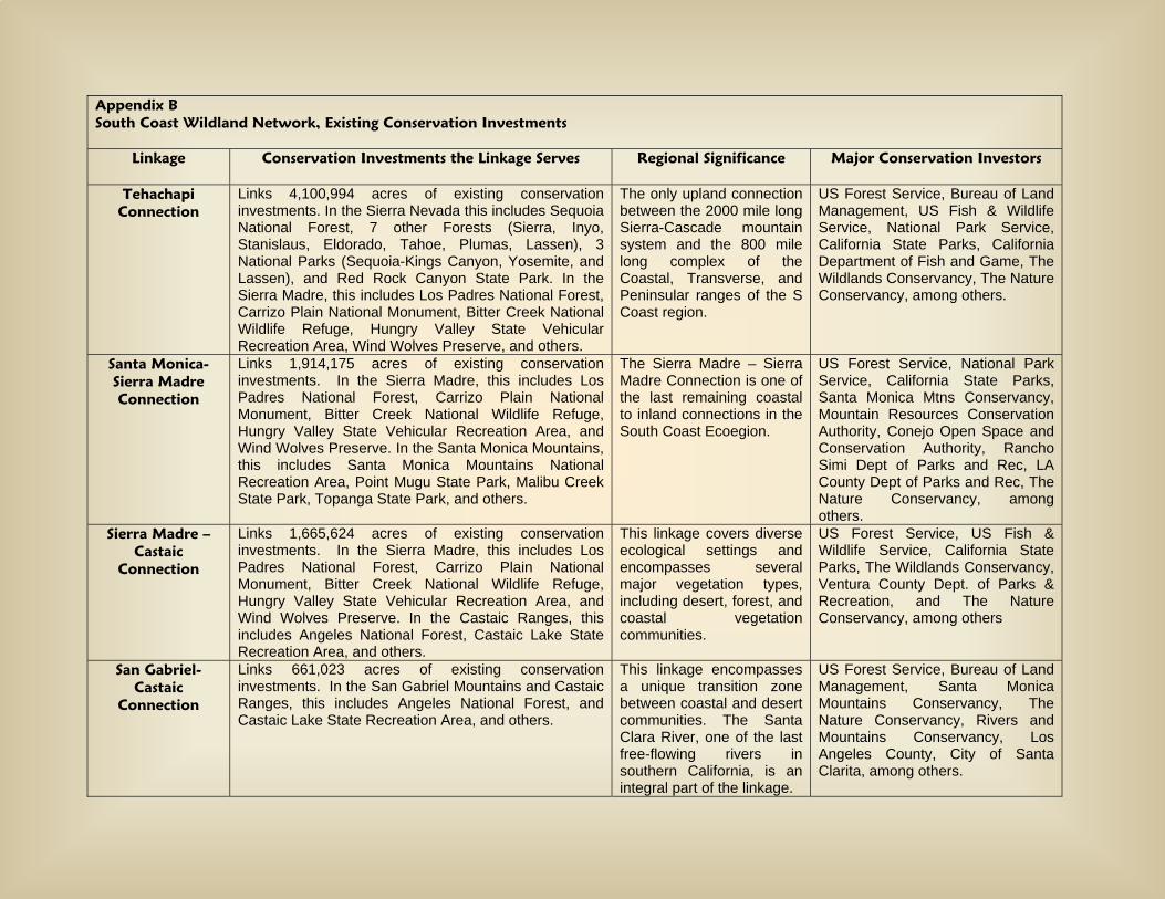
Appendix B South Coast Wildland Network, Existing Conservation Investments
Linkage Conservation Investments the Linkage Serves
Regional Significance Major Conservation Investors
Tehachapi Connection
Links 4,100,994 acres of existing conservation investments. In the Sierra Nevada this includes Sequoia National Forest, 7 other Forests (Sierra, Inyo, Stanislaus, Eldorado, Tahoe, Plumas, Lassen), 3 National Parks (Sequoia-Kings Canyon, Yosemite, and Lassen), and Red Rock Canyon State Park. In the Sierra Madre, this includes Los Padres National Forest, Carrizo Plain National Monument, Bitter Creek National Wildlife Refuge, Hungry Valley State Vehicular Recreation Area, Wind Wolves Preserve, and others.
The only upland connection between the 2000 mile long Sierra-Cascade mountain system and the 800 mile long complex of the Coastal, Transverse, and Peninsular ranges of the S Coast region.
US Forest Service, Bureau of Land Management, US Fish & Wildlife Service, National Park Service, California State Parks, California Department of Fish and Game, The Wildlands Conservancy, The Nature Conservancy, among others.
Santa Monica- Sierra Madre Connection
Links 1,914,175 acres of existing conservation investments. In the Sierra Madre, this includes Los Padres National Forest, Carrizo Plain National Monument, Bitter Creek National Wildlife Refuge, Hungry Valley State Vehicular Recreation Area, and Wind Wolves Preserve. In the Santa Monica Mountains, this includes Santa Monica Mountains National Recreation Area, Point Mugu State Park, Malibu Creek State Park, Topanga State Park, and others.
The Sierra Madre – Sierra Madre Connection is one of the last remaining coastal to inland connections in the South Coast Ecoegion.
US Forest Service, National Park Service, California State Parks, Santa Monica Mtns Conservancy, Mountain Resources Conservation Authority, Conejo Open Space and Conservation Authority, Rancho Simi Dept of Parks and Rec, LA County Dept of Parks and Rec, The Nature Conservancy, among others.
Sierra Madre – Castaic
Connection
Links 1,665,624 acres of existing conservation investments. In the Sierra Madre, this includes Los Padres National Forest, Carrizo Plain National Monument, Bitter Creek National Wildlife Refuge, Hungry Valley State Vehicular Recreation Area, and Wind Wolves Preserve. In the Castaic Ranges, this includes Angeles National Forest, Castaic Lake State Recreation Area, and others.
This linkage covers diverse ecological settings and encompasses several major vegetation types, including desert, forest, and coastal vegetation communities.
US Forest Service, US Fish & Wildlife Service, California State Parks, The Wildlands Conservancy, Ventura County Dept. of Parks & Recreation, and The Nature Conservancy, among others
San Gabriel- Castaic
Connection
Links 661,023 acres of existing conservation investments. In the San Gabriel Mountains and Castaic Ranges, this includes Angeles National Forest, and Castaic Lake State Recreation Area, and others.
This linkage encompasses a unique transition zone between coastal and desert communities. The Santa Clara River, one of the last free-flowing rivers in southern California, is an integral part of the linkage.
US Forest Service, Bureau of Land Management, Santa Monica Mountains Conservancy, The Nature Conservancy, Rivers and Mountains Conservancy, Los Angeles County, City of Santa Clarita, among others.
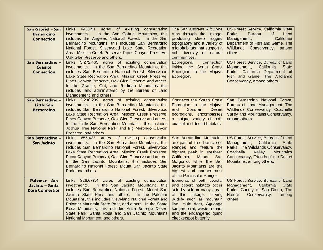
San Gabriel – San Bernardino Connection
Links 948,451 acres of existing conservation investments. In the San Gabriel Mountains, this includes the Angeles National Forest. In the San Bernardino Mountains, this includes San Bernardino National Forest, Silverwood Lake State Recreation Area, Mission Creek Preserve, Pipes Canyon Preserve, Oak Glen Preserve and others.
The San Andreas Rift Zone runs through the linkage, producing steep rugged topography and a variety of microhabitats that support a rich diversity of natural communities.
US Forest Service, California State Parks, Bureau of Land Management, California Department of Fish and Game, The Wildlands Conservancy, among others.
San Bernardino – Granite
Connection
Links 3,272,463 acres of existing conservation investments. In the San Bernardino Mountains, this includes San Bernardino National Forest, Silverwood Lake State Recreation Area, Mission Creek Preserve, Pipes Canyon Preserve, Oak Glen Preserve and others. In the Granite, Ord, and Rodman Mountains this includes land administered by the Bureau of Land Management, and others.
Ecoregional connection linking the South Coast Eocregion to the Mojave Ecoregion.
US Forest Service, Bureau of Land Management, California State Parks, California Department of Fish and Game, The Wildlands Conservancy, among others.
San Bernardino – Little San
Bernardino
Links 3,236,289 acres of existing conservation investments. In the San Bernardino Mountains, this includes San Bernardino National Forest, Silverwood Lake State Recreation Area, Mission Creek Preserve, Pipes Canyon Preserve, Oak Glen Preserve and others. In the Little San Bernardino Mountains, this includes Joshua Tree National Park, and Big Morongo Canyon Preserve, and others.
Connects the South Coast Ecoregion to the Mojave and Sonoran Desert ecoregions, encompasses a unique variety of both coastal and desert habitats.
San Bernardino National Forest, Bureau of Land Management, The Wildlands Conservancy, Coachella Valley and Mountains Conservancy, among others.
San Bernardino – San Jacinto
Links 656,423 acres of existing conservation investments. In the San Bernardino Mountains, this includes San Bernardino National Forest, Silverwood Lake State Recreation Area, Mission Creek Preserve, Pipes Canyon Preserve, Oak Glen Preserve and others. In the San Jacinto Mountains, this includes San Bernardino National Forest, Mount San Jacinto State Park, and others.
San Bernardino Mountains are part of the Transverse Ranges and feature the highest peak in southern California, Mount San Gorgonio, while the San Jacinto Mountains are the highest and northernmost of the Peninsular Ranges.
US Forest Service, Bureau of Land Management, California State Parks, The Wildlands Conservancy, Coachella Valley Mountains Conservancy, Friends of the Desert Mountains, among others.
Palomar – San Jacinto – Santa
Rosa Connection
Links 826,678.4 acres of existing conservation investments. In the San Jacinto Mountains, this includes San Bernardino National Forest, Mount San Jacinto State Park, and others. In the Palomar Mountains, this includes Cleveland National Forest and Palomar Mountain State Park, and others. In the Santa Rosa Mountains, this includes Anza Borrego Desert State Park, Santa Rosa and San Jacinto Mountains National Monument, and others.
Elements of both coastal and desert habitats occur side by side in many areas of this linkage, serving wildlife such as mountain lion, mule deer, Aguanga kangaroo rat, western toad, and the endangered quino checkerspot butterfly.
US Forest Service, Bureau of Land Management, California State Parks, County of San Diego, The Nature Conservancy, among others.
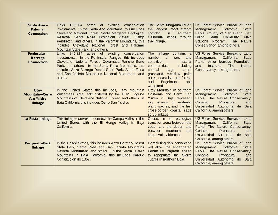
Santa Ana – Palomar
Connection
Links 199,904 acres of existing conservation investments. In the Santa Ana Mountains, this includes Cleveland National Forest, Santa Margarita Ecological Reserve, Santa Rosa Ecological Plateau, Camp Pendleton, and others. In the Palomar Mountains, this includes Cleveland National Forest and Palomar Mountain State Park, and others.
The Santa Margarita River, the longest intact stream corridor in southern California, winds through the linkage.
US Forest Service, Bureau of Land Management, California State Parks, County of San Diego, San Diego State University Field Stations Program, The Nature Conservancy, among others.
Peninsular – Borrego
Connection
Links 845,224 acres of existing conservation investments. In the Peninsular Ranges, this includes Cleveland National Forest, Cuyamaca Rancho State Park, and others. In the Santa Rosa Mountains, this includes Anza Borrego Desert State Park, Santa Rosa and San Jacinto Mountains National Monument, and others.
The linkage contains a number of rare and sensitive natural communities, including coastal sage scrub, grassland, meadow, palm oasis, coast live oak forest, and Engelmann oak woodland
US Forest Service, Bureau of Land Management, California State Parks, Anza Borrego Foundation and Institute, The Nature Conservancy, among others.
Otay Mountain─Cerro
San Ysidro linkage
In the United States this includes, Otay Mountain Wilderness Area, administered by the BLM, Laguna Mountains of Cleveland National Forest, and others. In Baja California this includes Cerro San Ysidro.
Otay Mountain in southern California and Cerra San Ysidro in Baja represent sky islands of endemic plant species, and the last cross-border coastal sage scrub linkage.
US Forest Service, Bureau of Land Management, California State Parks, The Nature Conservancy, Conabio, Pronatura, and Universidad Autonoma de Baja California, among others.
La Posta linkage
This linkages serves to connect the Campo Valley in the United States with the El Hongo Valley in Baja California.
Occurs in an ecological transition zone between the coast and the desert and between mountain and inland valley biomes.
US Forest Service, Bureau of Land Management, California State Parks, The Nature Conservancy, Conabio, Pronatura, and Universidad Autonoma de Baja California, among others.
Parque-to-Park linkage
In the United States, this includes Anza Borrego Desert State Park, Santa Rosa and San Jacinto Mountains National Monument, and others. In the Sierra Juarez Mountains in Baja California, this includes Parque Constitucion de 1857.
Completing this connection will allow the endangered Peninsular bighorn sheep to repopulate the Sierra Juarez in northern Baja.
US Forest Service, Bureau of Land Management, California State Parks, The Nature Conservancy, Conabio, Pronatura, and Universidad Autonoma de Baja California, among others.
Appendix C Literature Cited
Allan, J.D. 1995. Stream ecology: structure and function of running waters, Chapman and
Hall, New York. Allen, J.C. 2001. Summary of Ecological Findings for Malibu. California Coastal
Commission. Barnum, S.A. 2003. Identifying the best locations along highways to provide safe crossing
opportunities for wildlife: a handbook for highway planners and designers. Colorado Department of Transportation.
Barton, D.R., W.D. Taylor, and R.M. Biette. 1985. Dimensions of riparian buffer strips required to maintain trout habitat in southern Ontario (Canada) streams. North American Journal of Fisheries Management 5:364-378.
Baxter, C. 2001. An integrated approach to bird conservation in the Mississippi Alluvial Valley. Keynote Address. Riparian Habitat and Floodplains Conference March 12-14, 2001, Sacramento, California.
Beier, P., K. L. Penrod, C. Luke, W. D. Spencer, and C. Cabañero. 2006. South Coast Missing Linkages: Restoring connectivity to wildlands in the largest metropolitan area in the United States. Chapter In K R. Crooks and MA Sanjayan, editors, Connectivity conservation: maintaining connections for nature. Cambridge University Press.
Beier, P. and R. Barrett. 1993. The cougar in the Santa Ana Mountain Range, California. Final Report for Orange County Cooperative Mountain Lion Study.
Beier, P., and S. Loe. 1992. A checklist for evaluating impacts to wildlife movement corridors. Wildlife Society Bulletin 20:434-440.
Borowske, J.R. and M.E. Heitlinger. 1981. Survey of native prairie on railroad rights-of-way in Minnesota. Transportation Research Records (Washington) 822:22-6.
Brosofske, K.D., J. Chen, R.J. Naiman, and J.R. Franklin. 1997. Harvesting effects on microclimatic gradients from small streams to uplands in western Washington. Ecological Applications 7:1188-1200.
Bureau of Land Management. 2005. Environmental Impact Report and Statement for the West Mojave Plan and California Desert Conservation Area Plan Amendment.
Bureau of Land Management. 2003. Draft Environmental Impact Report and Statement for the West Mojave Plan and California Desert Conservation Area Plan Amendment.
Cain, A.T., V.R. Tuovila, D.G. Hewitt, and M.E. Tewes. 2003. Effects of a highway and mitigation projects on bobcats in Southern Texas. Biological Conservation 114: 189-197.
California Department of Fish and Game. 2005. Rare Find California Natural Diversity Database.
Clevenger, A.P., and J. Wierzchowski. 2006. Maintaining and restoring connectivity in landscapes fragmented by roads. Chapter in K. R. Crooks and M. A. Sanjayan, editors. Connectivity conservation: maintaining connections for nature. Oxford University Press.
Clevenger, A.P., and N. Waltho. 2005. Performance indices to identify attributes of highway crossing structures facilitating movement of large mammals. Biological Conservation 121: 453-464.
Clevenger, A.P., B. Chruszcz, and K.E. Gunson. 2003. Spatial patterns and factors influencing small vertebrate fauna road-kill aggregations. Biological Conservation 109: 15-26.
Clevenger, A.P., B. Chruszcz, and K. Gunson. 2001. Drainage culverts as habitat linkages and factors affecting passage by mammals. Journal of Applied Ecology 38: 1340-1349.
Clevenger, A.P., and N. Waltho. 2000. Factors influencing the effectiveness of wildlife
underpasses in Banff National Park, Alberta, Canada. Conservation Biology 14: 47-56.
Coachella Valley Association of Governments(CVAG). 2004. Coachella Valley Multiple Species Habitat Conservation Plan and Natural Community Conservation Plan Public Review Draft October 15, 20004. Volume 1 The Plan. Prepared for Coachella Valley Association of Governments, prepared by Coachella Valley Mountains Conservancy.
County of Riverside. 2002. Western Riverside County Multiple Species Habitat Conservation Plan Draft EIR/EIS. Riverside County Integrated Project.
Craighead, A.C., E. Roberts, and F. L. Craighead. 2001. Bozeman Pass Wildlife Linkage and Highway Safety Study. Prepared for American Wildlands, http://www.wildlands.org/research.html.
Dodd, C.K, W.J. Barichivich, and L.L. Smith. 2004. Effectiveness of a barrier wall and culverts in reducing wildlife mortality on a heavily traveled highway in Florida. Biological Conservation 118: 619-631.
Edelman, P. 1991. Critical Wildlife Corridor/Haibtat Linkage Areas between the Santa Susana Mountains, the Simi Hills and the Santa Monica Mountains. Prepared for The Nature Conservancy.
Evink, G.L. 2002. Interaction between roadways and wildlife ecology. National Academy Press, Washington, D.C.
Fisher, R., and K. Crooks. 2001. Baseline biodiversity survey for the Tenaja Corridor and southern Santa Ana Mountains. U.S. Geological Survey Biological Resources Division and Department of Biology, San Diego State University, San Diego, California.
Forman, R.T.T., D. Sperling, J.A. Bissonette, A.P. Clevenger, C.D. Cutshall, V.H. Dale, L. Fahrig, R. France, C.R. Goldman, K. Heanue, J.A. Jones, F.J. Swanson, T. Turrentine, and T.C. Winter. 2003. Road Ecology: Science and Solutions. Island Press, Washington, D.C.
Forman, R.T.T. 1995. Land Mosaics: The Ecology of Landscapes and Regions. Cambridge University Press, Cambridge, England.
Gordon, K.M. et al. 2001. Motorist response to deer-sensing system in western Wyoming. In: The proceeding of the international conference of wildlife ecology and transportation. Keystone, Colorado.
Hanski, I., and M. Gilpin. 1991. Metapopulation Dynamics. Academic Press, London. Huijser, M. P. and P. T. McGowen. 2003. Overview of animal detection and animal warning
systems in North America and Europe. Pp. 368-382, in: The International Conference on Ecology and Transportation (ICOET); August 24-29, 2003; Lake Placid, NY.
Kohn, M.H., E.C. York, D.A. Kamradt, G. Haught, R.M. Sauvajot, and R.K. Wayne. 1999. Estimating population size by genotyping faeces. Proc. Royal Soc. (Series B) 266: 657-663.
Kreuper, D.J. 1992. Effects of land use on western riparian ecosystems. In: D.M. Finch and P.W. Stangel, eds. Status and Management of Migratory Birds. U.S.D.A. Forest Service General Technical Report RM-229.
LaHaye, W.S., R.J. Gutierrez, and J.R. Dunk. 2001. Natal dispersal of the spotted owl in southern California: dispersal profile of an insular population. Condor 103:691-700.
Little, S.J. 2003. The influence of predator-prey relationships on wildlife passage evaluation. ICOET 2003.
LSA Associates, Inc. 2004. Final Wildlife Corridor Assessment Ventura State Route 118. Prepared for CalTrans District 7 Division of Environmental Planning. Prepared by LSA Associates, Inc.
Marzluff, J.M., and K. Ewing. 2001. Restoration of fragmented landscapes for the conservation of birds: a general framework and specific recommendations for urbanizing landscapes. Restoration Ecology. 9:280-292.
Mata, C., I. Hervas, J. Herranz, F. Suarez, and J.E. Malo. 2005. Complementary use by vertebrates of crossing structures along a fences Spanish motorway. Biological Conservation 124: 397-405.
McDonald, W. and C.C. St Clair. 2004. Elements that promote highway crossing structure use by small mammals in Banff National Park. Journal of Applied Ecology 41:82-93.
Messmer, T.A., C.W. Hedricks, and P.W. Klimack. 2000. Modifying human behavior to reduce wildlife-vehicle collisions using temporary signing. In: Wildlife and highways: seeking solutions to an ecological and socio-economic dilemma. September 12-16: Nashville, TN.
Myers, S.J., S. Ogg, and L.F. LaPré. 1996. Potential wildlife corridors in the San Gorgonio Pass: Initial Report. Prepared for The Wildlands Conservancy; prepared by Tierra Madre Consultants, Inc.
Ng, S.J., J.W. Dole, R.M. Sauvajot, S.P.D. Riley, and T.J. Valone. 2004. Use of highway undercrossings by wildlife in southern California. Biological Conservation 115, pp. 499-507.
Ng, S.J. 2000. Wildlife use of underpasses and culverts crossing beneath highways in southern California. MS Thesis, California State University Northridge, Northridge, CA. 58pp.
Psomas. 2002. Regional wildlife corridors, wildlife utilization, and open space in the Simi Valley region, Ventura and Los Angeles Counties, California, revised draft, June 17. Prepared for Unocal Land and Development Company by Psomas Natural Resources Group. Costa Mesa, California. June 17.
Reed, D.M. and J.A. Schwarzmeier. 1978. The prairie corridor concept: possibilities for planning large scale preservation and restoration. In Lewin and Landers (eds) Proceedings of the Fifth Midwest Prairie Conference, pp. 158-65. Iowa State University, Ames, Iowa, USA.
Reed, D.F. 1981. Effectiveness of highway lighting in reducing deer-vehicle accidents. Journal of Wildlife Management. 45:1981.
Riley, S.P.D., J.P. Pollinger, R.M. Sauvajot, E.C. York, C. Bromley, T.K. Fuller, and R.K. Wayne. 2006a. A southern California freeway is a physical and social barrier to gene flow in carnivores. Molecular Ecology 15: 1733-1741.
Riley, S.P.D., R.M. Sauvajot, T.K. Fuller, E.C. York, D.A. Kamradt, C. Bromley, and R.K. Wayne. 2003. Effects of urbanization and habitat fragmentation on Bobcats and coyotes in southern California. Conservation Biology 17:566-576.
Robinson, M., P. McGowen, A. Habets, and C. Strong. 2002. Safety Applications of ITS in Rural Areas. Section 7.1.1. Science Applications International Corporation, McLean, VA, USA.
Ruediger, B. 2001. High, wide, and handsome: designing more effective wildlife and fish crossings for roads and highways. ICOET 2001.
Sauvajot, R.M., E.C. York, T.K. Fuller, H.S. Kim, D.A. Kamradt, and R.K. Wayne. 2000. Distribution and status of carnivores in the Santa Monica Mountains, California: preliminary results from radio telemetry and remote survey camerias. In: Keeley, J.E., M.B. Baer-Keeley, and C.J. Fotheringham (Eds.), Second interface between Ecology and Land Development in California. US Geological Survey, Sacramento, CA. pp. 113-123.
Singleton, P.H., W.L. Gaines, and J.F. Lehmkuhl. 2002. Landscape Permeability for Large Carnivores in Washington: A Geographic Information System weighted-distance and least-cost corridor assessment. USDA Forest Service, Pacific Northwest Research Station, Research Paper PNW-RP-549.
Soulé, M.E. 1989. USDI-National Park Service Proposed Land Exchange: Wildlife Corridors. Unofficially released report prepared for the Santa Monica Mountains National Recreation Area.
Sweanor, L., Logan, K., Bauer, J., and W. Boyce. 2003. Southern California Puma Project June 2003 Progress Report for Interagency Agreement No. C0043040 (California State Parks and the University of California, Davis)
USDA Forest Service. 2004. Draft Environmental Impact Statement for Revised Land Managmenet Plans: Angeles National Forest, Cleveland National Forest, Los Padres National Forest, and San Bernardino National Forest. Pacific Southwest Region, R5-MB-045, May 2004.
Walker, R. and L. Craighead. 1997. Analyzing Wildlife Movement Corridors in Montana Using GIS. ESRI User Conference Proceedings.
White, M.D., J.A. Stallcup, W.D. Spencer, J.R. Strittholt, and G.E. Heilman. 2003. Conservation significance of Tejon Ranch: a biogeographic crossroads. Unpublished report prepared prepared by the Conservation Biology Institute for Environment Now. August. http://www.consbio.org/cbi/pubs/index.htm
Wilson, J.D. and M.E. Dorcas. 2003. Effects of habitat disturbance on stream salamanders: Implications for buffer zones and watershed management. Conservation Biology 17: 763-771.
Yanes, M., J.M. Velasco, and F. Suárez. 1995. Permeability of roads and railways to vertebrates: the importance of culverts. Biological Conservation 71: 217-222.

Preferred Citation: South Coast Wildlands. 2008. South Coast Missing Linkages: A Wildland Network for the South Coast Ecoregion. Produced in cooperation with partners in the South Coast Missing Linkages Initiative. Available online at http://www.scwildlands.org.