South Central Coast Appendix J Public Involvement and Scoping
122
Integrated Draft Feasibility Report & EIS November 2019 Page J-1 South Central Coast LA Study Appendix J Public Involvement and Scoping INTEGRATED DRAFT FEASIBILITY REPORT APPENDIX J PUBLIC INVOLVEMENT AND SCOPING U.S. Army Corps of Engineers Mississippi Valley Division New Orleans District 7400 Leake Avenue New Orleans, Louisiana 70118 November 2019
Transcript of South Central Coast Appendix J Public Involvement and Scoping

Integrated Draft Feasibility Report & EIS
November 2019 Page J-1
South Central Coast LA Study Appendix J Public Involvement and Scoping
INTEGRATED DRAFT FEASIBILITY REPORT
APPENDIX J PUBLIC INVOLVEMENT AND SCOPING
U.S. Army Corps of Engineers Mississippi Valley Division
New Orleans District 7400 Leake Avenue
New Orleans, Louisiana 70118
November 2019

South Central Coast LA Study Appendix D Economics
Integrated Draft November 2019 Feasibility Report & EIS Page J-2
I. Initial Information Exchange Meetings (Week of November 5th-9th)
II. Meeting Distribution Execution
a. INVITE DISTRIBUTION i. Resource Agencies - Distributed on October 17th, 2018
ii. Interested Parties - Distributed on October 25th, 2018
b. DISTRIBUTION LIST i. Parish Planning Boards
Invitees: Rachel Godeaux (Project Manager), Tammy Luke, and Heath Babineaux ii. Emergency Managers
Invitees: Duval H. Arthur Jr. (Director), LTC. Terry E. Guidry, (Director), and Prescott Marshall (Director)
iii. Non-Profit Interest Groups Invitees: Harold Schoeffler, and Donald Sagrera
iv. Levee Boards Invitees: Mr. Bill Hidalgo (President), Mike Brocato, Ray Fremin, and including contacts from Red River – Atchafalya & Bayou Boeuf Levee District
v. Parish Engineers and Councilmembers Invitees: David Hanagriff (President), M. Larry Richard (President), Chester R. Cedars (President), and Thayer Jones (Civil Engineer)
vi. Cities and Towns Coordination Invitees: Ricky Calais (Mayor), Melinda Mitchell (Mayor), Mike Fuselier (Mayor Pro tem), Freddie DeCourt (Mayor), Dan Doerle (Mayor Pro Tem), April Foulcard (Mayor), Brad Clifton (Mayor), Frank P. Grizzaffi III, Louis Ratcliff, Rodney A. Grogan (Mayor), Eugene P. Foulcard (Mayor), Lester Levine (Mayor Pro Tem), and including contacts from Baldwin and Delcambre
vii. Industry Coordination Invitees: Duane Lodrigue, Craig F. Romero (Executive Director), Roy A. Pontiff (President), and including contacts from Port of West St. Mary, Harry P. Williams Memorial Airport, Bayou Boeuf Lock, and Berwick Lock
viii. Tribal Coordination Invitees: Rachel Watson, Charles R. McGimsey, Nicole Hobson-Morris, Andrea McCarthy, Kimberly Walden
III. PUBLICATIONS
a. PRESS RELEASES
i. Posted 11/07/2018: “South Central Coast Study on Display”- Dredging Today ii. Posted 11/06/2018: “Corps to host public meetings in St. Martin, St. Mary parishes”- KATC
b. PUBLIC NOTICES i. Posted 11/06/2018:“Corps to host public meetings to discuss South Central Coast Study”-MVN
Webpage ii. Advertisement of Meetings - Daily Iberian
iii. Advertisement of Meetings - Acadiana Advocate c. PUBLICATION PARTICIPANTS (INDIVIDUAL NEWS/PAPER AGENCIES)
i. Dredging Today https://www.dredgingtoday.com/2018/11/07/south-central-coast-study-on-display/
ii. KATC https://katc.com/news/around-acadiana/2018/11/06/corps-to-host-public-meetings-in-st-martin-st-mary-parishes/
iii. Daily Iberian (print) iv. Acadiana Advocate (print)
IV. MEETINGS #1 i. INTRODUCTORY INFORMATION
PDT meeting with Resource and Permitting Agencies • When: Tuesday, November 6, 2018, 1230-1400 • Location: MVN District Office, Conference Room 125
ii. ATTENDANCE Joe Jordan, Karla Sparks, Brian Johnson, Carrie Schott, Jeremiah Kaplain, Jason Emory, Haydell Collins, Elizabeth Behrens, Bill Klein, Marshall Plumley; Craig Gothreaux; Dave Walther, Ronald Paille; Gary Zimmerer; Michelle Meyers
iii. SUMMARY OF DISCUSSION Introduction
Project Environmental Lead, Joe Jordan conducted introductions, and presented a project overview PowerPoint presentation, the presentation addressed project authority, schedule, existing data, and data gaps.
Discussion Topics: 1. FWS- Critical Habitat
There is designated critical habitat in the study area for the gulf sturgeon. 2. Endangered Species
The USFWS could provide a Planning Aid Letter discussing the potential federally listed species in the study area. - Follow-up: Mr. Paille provided a draft PAL on November 20, 2018 (attached)).
3. Land loss USGS has the most up to date information. - Follow-up: Ms. Meyers provided additional data sources on November 7, 2018.
4. Invasive Specie data source Terrebonne estuary website
5. Clean Water Act 404(c) lands Check with USEPA for any designated 404(c) lands.
6. Wetland Value Assessment Corps POCs are Patrick Smith and Daniel Meden. The USFWS may conduct the effort however. - Follow-up: The MVN provided Fish and Wildlife Coordination Act funds to the
USFWS. Part of this funding included the field work and WVA evaluation. 7. Nature-based Alternatives
Consensus from the groups supported nature based alternatives but wind, water, and storm surge could require more substantive alternatives. We could investigate using native grass seed rather than turf grass for any alternative requiring a grass cover. Lake Pontchartrain Foundation may be an example to follow. For nature based solutions. The resource agencies preferred levee placement as much as possible agricultural fields rather than wetlands for any levee alignment.
8. Group consensus was salinity may not be a problem in the study area. 9. Louisiana's Coast wide Reference Monitoring System (CRMS) (USGS) website has existing
water quality monitoring data. https://www.usgs.gov/centers/wetland-and-aquatic-research-center/science/louisiana%E2%80%99s-coastwide-reference-monitoring?qt-science_center_objects=0#qt-science_center_objects
10. GIS

The MVN GIS team could provide state lands; FWS website has FWS refuge lands such as the Bayou Teche SE NWR complex real estate layers.
11. The Coastal Protection and Restoration Authority’s website has a lot of data including the current State Masterplan with GIS information
12. Aerial photography - The final product may not be ready until August 2019. CRMA is flying the 2018 routes now.
13. High Impact mapping (from flooding and storms): FEMA has these maps. 14. Constraints
Constraint 1: Proposed flood walls should allow wildlife passages every 3 miles. Constraint2: Keep water flowing; avoid stagnation.
15. Risk and Uncertainty Risk and uncertainty 1: Sizing outlets large enough for interior drainage versus using holding areas/smaller outlets for habitat value. This may not be acceptable to farmers and land owners. Risk and uncertainty 2: Induced flooding outside the planning area, particularly to the west. Risk and uncertainty 3: The report should articulate coastal storm surge, overland river flooding, and interior rain flooding to the public.
b. MEETING #2-3
i. INTRODUCTORY INFORMATION Stakeholder Meeting • When: Wednesday, November 7, 2018, 1300-1500 • Location: St Peter Street Branch Library, 1111 W Saint Peter Street, New Iberia, LA 70560
Public Meeting • When: Wednesday, November 7, 2018, 1800-2000 • Location: Cade Community Center, 1688 Smede Highway, St. Martinsville, LA. 70582 • A court reporter documented this meeting in writing. This record is included at the end of this
appendix. ii. ATTENDANCE
Karla Sparks, Brad Inman, Carrie Schott, Joe Jordan, Jeremiah Kaplan, Brian Maestri, Britt Corley, Stacey Frost, Justin Merrifield, Wes LeBlanc, Kristen Ramsey, Alexis Ritner, Harold Schoeffler, Benson J Langlinias, Donald Segrera, Dave Dixon, Brent Logan, Woody Anderson
iii. SUMMARY OF DISCUSSION Discussion Topics:
1. 2016 event and river flooding. - Will this be part of the study? 2. Ben Langlinias Iberia LD:
Vermillion Bay the biggest storm surge and wanted to be a part of the SW study. Political boundaries don’t work. (Encourage study to look broader when modeling water.)
3. SW and SC study need to be put together. CPRA study has it all. Master Plan.
4. Need models to help flood way and regional flooding, not just hurricane surge. FEMA requires certification for both.
5. Vermillion was cut in half based on the SW study 6. Need to study watersheds
Not parish boundaries, Authority is just for the parishes (Brad), Wasting time not looking at hydraulic units not parish boundaries.
7. Our analysis has the obligation to not move flood risk outside the study area Add: Stacey Frost – H&H will done at the watershed level but actions will be limited to within boundaries.
8. Harold Schoeffler, Sierra Club:

Highway 90 route was under water for 10 days. Potential options include: Going to raise the land, Build bridges, Hurricane evacuation – not rain events (Brad)
9. Wes LaBlanc: Dollar value for highway 90 effectiveness. Brian M. says benefits are time/costs in getting back to the area. CPRA will help gather delay costs (to traffic and industry restart up)
10. Henry Hub property is the most expensive property and should be part of the project area (west of the project area)
11. We look at 1% for surge. 10% for rainfall regardless of when the rain falls 12. Ben Langlinias, Iberia LD
Likes the idea of a locally preferred plan. We can do this right, we just need the money to do it.
13. Harold Schoeffler, Sierra club Will you model the Atchafalaya - can’t handle the flood? The depth is insufficient to handle a flood will the study look at riverine flooding? 1. MRC is studying this along the Atchafalaya (Brad) 2. Another study old river control study, not this one.
14. Are probabilities of floods increasing? - Yes (Stacey) We have current probability curves.
15. Rainfall occurrences are increasing. - Yes 16. FEMA numbers show areas where damages (Brit)
The group needs to help us show where the damages are too. 17. Long discussion on flood insurance who has it who does not. 18. Infrastructure in place could a small portion.
There is accelerate building now. They presented some of this data to the corps before. Use existing lock to release water. Is there a system wide flood control project and run by the corps?
1. Could be an alternative? (Stacey) – System Operation Optimization could be an alternative.
2. May need additional authority. (Stacey) 3. Mark Wingate and Nick Simmshas have been given a study concerning this. 4. Brad will ask them about it.
19. Rita, Isaac, Audrey are the worst hurricanes to hit Iberia 20. Sea level rise
Answered how it is calculated (Stacey), Sierra Club says 1 foot per century at Venice LA gauge. USACE will evaluate see level rise in project.
21. Sierra Club – riverine, hurricane, rainfall. All occur at the same time or can these be separated
22. Projects only found in the 2017 masterplan can be considered. 23. Sierra club – had a project dismissed –Charitan Cut - a closure/dredge project.
St Mary Parish was trying to do this project for many other parishes. 24. Will FEMA be part of this study? – Yes, FEMA will be invited to participate as a cooperating
agency.
c. MEETING #4-5 i. INTRODUCTORY INFORMATION
Stakeholder Meeting • When: Thursday, November 8, 2018, 1300-1500 • Location: St. Mary Parish Library West End Branch, 100 Chitimacha Trail, Baldwin, LA 70514
Public Meeting • When: Thursday, November 8, 2018, 1800-2000 • Location: Morgan City Municipal Auditorium, 728 Myrtle Street, Morgan City, LA 70380

• A court reporter documented this meeting in writing. This record is included at the end of this appendix.
ii. ATTENDANCE Karla Sparks, Jason Emery, Carrie Schott, Joe Jordan, Jeremiah Kaplan, Brian Maestri, Britt Corley, Sarah Bradley, Stacey Frost, Wes LeBlanc, Kristen Ramsey, Alexis Ritner, Jay Vicknair, Cindy Cutrera, Michael Elay, Tim Matte
iii. SUMMARY OF DISCUSSION (See Court Reporter’s notes) Discussion Topics:
1. Two agencies ST Mary homeland security & parish district need to be consulted.
2. Bayou Shane’s control structure is coming on line St. Mary and St. Martin parishes design stage and waiting for funding.
3. WRDA supposed to be looking at the old river lock 70/30 split bet Miss and Atchafalaya needs to be looked at.
4. Delta at the Wax Lake Funnels water if flooding - then Morgan City gets it. Shallow areas in the bay nowhere for the water to go - needs to be looked at. There is economic loss from this work loss. Temp structure - can’t afford to put it back in. Not a national loss since the work was picked up somewhere else in the country. Can use the cost of added O&M to the businesses affected.
5. Would help as a reference to look at claims. 6. Arcadia planning commission is modelling on the watershed 7. Governor has a commission for state watershed modelling.
Maybe DOT - LA watershed data exchange Nov 15, Cindy O’Neail State floodplain manager may have data.
8. Bayou Shane permit may have a lot of information. Cost benefit will dictate the level of protection. St Mary MP have additional levee alternatives.
1. Plus Morgan City has a local levee system at 1% that is not reflected in corps information.
2. West of Chariton canal there is certain levee alternatives St Mary is looking at. 9. Cedar Ray study
Cost estimate was geared to 1% if there is something different they can readjust to get a good BC ratio.
10. SW coastal levee to Delcambre was costly it should go straight east because of study area limitation
We may hear about this from the public. 11. FEMA has a map of every structure damaged from the last flood 12. Some companies need to be in the unprotected zone, they have a higher OM cost no one is
measuring. 13. Old River complex
High water spending a lot on this. 14. Fuel docks 2011 flood – they had to empty the fuel tanks prior to damage, may be added cost
for economic impact. 15. Carbon black plants may have environmental costs if damaged 16. SW coast industry survey low response.
Industry doesn’t like to share info, maybe talk to chamber of commerce to encourage info sharing.
17. Stakeholder group – business along shore. Can encourage them to fill out any survey. Suggested having regular stakeholders meetings – maybe monthly webinars.

d. MEETING #6 i. INTRODUCTORY INFORMATION
Chitimacha Tribe of Louisiana South Central Coastal Louisiana Flood Risk Management Feasibility Study THPO Coordination Meeting • When: November 8th, 2018 • Where: 3289 Chitimacha Trail, Charenton, LA 70523
ii. ATTENDANCE Kimberly S. Walden, Tribal Historic Preservation Officer (THPO), Chitimacha Tribe of Louisiana (CTL); Jason A. Emery, RPA -MVD Cultural Resources RTS and MVN District Tribal Liaison Cultural & Social Resources Analysis Section (CEMVN-PDP-CSR) Regional Planning and Environment Division, South; Jeremiah Kaplan, RPA - Cultural & Social Resources Section (CEMVN-PDP-CSR), United States Army Corps of Engineers, New Orleans District Regional Planning and Environment Division, South.
iii. SUMMARY OF DISCUSSION Purpose:
Scoping meeting to introduce and provide the CTL THPO with a description and overview of the South Central Coastal Louisiana Flood Risk Management Feasibility Study Project (SCCL) in an effort to include the input of the CTL in the planning and development stage of the project.
Discussion Topics: 1. CEMVN provided Public Scoping Meeting handout materials for distribution on reservation
and provided a brief overview of key points regarding the SCCL project and its framework including:
CEMVN is preparing a feasibility report investigating hurricane protection, storm damage reduction and related purposes along the southern Louisiana coast. Specifically, the study authorization is tasking the District to survey the coast of Louisiana in Iberia, St. Martin, and St. Mary parishes to determine the feasibility of providing hurricane protection, storm damage reduction, and related purposes. CEMVN is investigating potential solutions including levees and floodwalls, hydraulic and salinity control structures, non-structural efforts, and shoreline stabilization measures. CEMVN will not be considering ecosystem restoration as was done in the 2016 Southwest Coastal Louisiana Multi-Purpose Study. The Coastal Protection and Restoration Authority Board (CPRA), is the project’s non-Federal sponsor. The study’s constraints under the “one agency, one decision” review structure including expedited project schedule. CEMVN is requesting feedback from CTL on where there are specific opportunities to reduce damages, risk, and increase life safety. Additionally, CTL was asked to identify any potential conflicts that CEMVN needed to be aware of during the development of alternatives. CTL’s participation and comments will contribute to the project thorough alternative analysis and environmental evaluation.
2. Specific feedback from CTL included: Charenton Floodgate Funding for two-way water control: hosted a couple of meetings on this and there is no money for the work at this time, but this feature is recognized as really risky for Tribes and others in the “Teche” (Bayou Teche). Cote Blanche Freshwater and Sediment Introduction, and Shoreline Protection Project, St. Mary Parish, Louisiana (Attachment 1): identified by CTL as a potential component for SCCL. Joint USACE/NCRS project. Already designed. Focuses on shoreline restoration and marsh creation (multiple lines of defense model-integration of naturally engineered features). Project not have been implemented due to the results of Hazard Magnetometer survey which showed numerous abandoned pipelines. Brad Inman (Senior Project Manager at US Army Corps of Engineers) was supporter of project. Potential problems to solve: 1) numerous abandoned pipelines; 2) funding approval; 3) may focus too much on ecosystem restoration. Cutting off Charenton Drainage Canal – may be good for Franklin but may cause problems for others on the west side of the Teche.

The SCCL project has the potential to affect the Lake Fausse Pointe, Dauterive Lake, and Grand Avoille Cove Ecosystem Plan (Attachment 2; Figure 1). This project aims to control extensive sedimentation/vegetative overgrowth affecting fish and wildlife habitat in the study area. Excerpt from letter to Col. Edward R. Fleming, District Engineer, USACE, from David Walther, USFWS, August 31, 2011:
The goal of the Lake Fausse Pointe Restoration Project is also to improve the natural fisheries habitat quality of the lake by reducing sedimentation of the lake and providing habitat for commercial and sport fish species…A system-wide approach to reduce sedimentation is needed to effectively improve fisheries habitat in the lake…The overall planning goal should incorporate the co-equal needs for continued drainage of storm-water runoff, sediment control, and fish and wildlife conservation.
3. Other discussion points of interest: The location marked as “Flood Area” in Figure 1 is subject to repetitive flooding. It is suspected that a private landowner is responsible for these releases. The CTL is interested in participating in the development of this study and is able to call a meeting with tribal community members and resource agency partners to provide additional feedback and direction during the development of alternatives. It was discussed that one of the major challenges to this study is that runoff (riverine and non-riverine) due to increasing flow from outside the project area (upstream and neighboring parishes) is presently one of the major factors impacting the study area.CTL has concerns that a structural solution that focuses on coastal levees has a high potential to impact a large number of cultural resources of tribal interest. Any land-based structure would likely be focused in areas that the Chitimacha have ancestral ties to. Levee alignments placed on the landward side of mounds have the potential to be especially problematic as do any backwater conditions created by levees during storm events that may impact tribal cultural resources. The CTL is willing to participate in the development of a programmatic agreement as a consulting party, but is very concerned about the treatment of cultural resources. USGS sea level rise projection specifically for the CTL was provided and should be addressed.
e. MEETING #7 i. INTRODUCTORY INFORMATION
PDT Second Iteration • When: Friday, November 09, 2018, 0830-1230. • Where: U.S. Army Corps of Engineers New Orleans District Office.
ii. ATTENDANCE Carrie Schott, Joe Jordan, Jeremiah Kaplan, Brian Maestri, Britt Corley, Chris Talbert, J. Haydell Collins ,Dave Beck, Karla Sparks, Marshall Plumley, Sarah Bradley, Evan Stewart, Bill Klein, Justin Merrifield, Wes LeBlanc, Kristen Ramsey, Alexis Ritner, Ricky Brouillette
iii. SUMMARY OF DISCUSSION Discussion Topics:
1. Problems & Opportunities a. Remove “by providing non-structural solution’s” b. Hwy 90 flooding (I-90 evacuation route (remove reliable as it isn’t reliable currently)
Where is the flooding occurring first?/Check with DOT to see if they have updated plans for Hwy 90.)
c. Flood Risk Statement will need to separate out rain fall events impacts and interior drainage issues from riverine and backwater flooding
d. Sea Level Rise (Team will need to look at low, med, and high scenario. - Haydel will check the differences between sea level rise projections within project area and make a recommendation which future scenario team should adopt., CPRA and Corps rates are different. - PDT to determine which one we will use, typically Corps medium estimate.)

e. Trends in water quality and salinity (Salt water intrusion issues and occurrence is not an everyday issue but with storm events it is an issue. Following Storm surge events, salt gets on the fields and then can’t get back out.)
f. Improve drainage could have negative consequences because it will generally increase the elevation the storm surge is able to go.
g.Existing levees in flood area were designed for riverine flooding do not provide storm damage reduction to the 1% hurricane criteria. (Planning team is not limited to the 1% reduction. Team will optimize level of protection based on impacts and consequences. - Remove percent in the hurricane and storm and damage risk reduction statement, need to assess flood risk to public utilities and services, hospitals, and critical infrastructure.)
h.Need to add statements about Oil and Gas infrastructure, Ports of Iberia and contributions to the nation
i. HTRW (Phase 1 will need to be complete when team gets more of a focused array or potentially after TSP. Dave Beck will check on who will be assigned to SCCL to complete HTRW assessment, prevention.)
j. Separate interior drainage problems (Need pumps to decrease interior flooding when gates are closed – Interior damage is induced flood damages behind levees.)
k.Have to pass design flows - (What is the design flow/what is the existing condition design flow, is this a constraint, and is this a salinity barrier?)
l. Locals want the 1% level of protection to reduce flood insurance 2. Goals and Objectives
a. Objective 1b change to interior and flooding to riverine and back-water flooding. b.Natural based feature won’t prevent storm surge but will reduce the wave height. c. Concern with objective 2 given the limitation in payment authorization. (This objective is
meant to capture WRDA 16 Sec 1184. - This guidance defines natural features and nature-based features and requires USACE to consider natural features, nature-based features, non-structural measures and structural measures as appropriate with studying the flood risk management, hurricane and storm damage reduction, and ecosystem restoration.)
d.Inventory and Forecasting Refinement e. Marsh loss over the last 50-60 years needs to be combined with sea level rise. (Can we
reasonably quantify the impacts of marsh creation vs. levee raises? - Comparison of costs, every mile of marsh a foot reduction of surge (1960’s USACE report), duration of storm can greatly effect this, hurricanes in 4 and 5 are expected to increase in number. (These types of measures are less able to with stand these types of storms.).) NOTE: Wave height and storm surge increase may use this matrix as a proxy of how these measures would perform.
f. Goal 2 - Reduce impact of feature marsh loss over the last 50 years and suture and sea level rise. (Can you quantify the FRM loss and tie this to levee height needs?)
3. Constraints a. Consistent with the LA Master plan. May be able to deviate if levee was in same corridor.
However would not be able to support a total non-structural alternative. b.Move north alignment to reduce leveed area c. Ring levees in the certain areas would likely not be supported by CPRA. d.Mandatory relocation- non consistent with CPRA LA Master Plan and not able to support. e. Non-mandatory relocation would align with CPRA LA Master Plan. f. Locally Preferred Plan option g.LA Master Plan will be updated in 2023. This sponsor will need to support an alternative
that aligns with the intent of the 2017 Master Plan h.Ag Mac - channel deepening to Port of Iberia (study about 12-15 years ago)

i. GIWW spoil banks- have been falling in and widening the channel. (GIWW seemed to provide a level of protection.)
4. Measure Identification and Alternative Formulation a. State levee alignment (Arcadis report) (could be minor variation in alignment; for
example smooth out 90 degree corners) b.Railroad alignment, this alignment would reduce the leveed protected area and length of
the levee c. Ring levees around New Iberia and Delcambre Franklin, Jeanerette, etc. This measure
would focus on the communities experiencing the reoccurring damages epicenters. CPRA stated would likely not be able to support this measure as it isn’t in alignment with LA Master Plan.
d.Levee raise on existing riverine authorized levees; lake wax, bayou teche, sale, ridge to protection from storm surge and hurricane
e. Shoreline protection feature (Northern Vermillion Bay Rim) feature would reduce erosion and storm surge impact in that location. Part of this feature alignment in LA Master Plan is outside of the Project area.
f. Road Raises- elevate critical infrastructure for evacuation purposes. St. Mary levee POC can provide specific location where I-90 goes under water quickly.
g.Marsh creation would serve to reduce storm surge impacts. (ADCERC runs on what type of protection this specific features provides. Measure will need to be justified on what FRM damages it can prevent as project funding authorization is limited to flood risk management.
5. Potential Measures a. Regular measures
1. Masterplan has proposed levee raises in the Morgan City area 2. Use ARCADAS report for structural and 2 levels of protection 3. Move levees out of the marsh into farmland 4. Look at all if all are required (so we don’t flood others – Dependency) Dependency vs
segments, ring levees around specific areas (New Iberia) 5. Combination of structure/nonstructural features 6. Pump station vs retention areas 7. Mash lake Area, Rabbit Key, Duck Key restoration for wave attenuation 8. Road raises or levees in the road ROWs 9. Nonstructural only 10. Consolidated water management across all entities and existing facilities – hydrology
is inconsistent and the plumbing is all different. State MP may be able to do this – Federal navigation may contribute to this also.
11. Shoreline protection may have storm surge marsh island protection since Marsh Island will be lost in 50 years
b.Non-Structural Measures 1. Marsh Island inlet closure would serve to reduce storm surge and wave heights. 2. Retention features on the inside of the leveed area (instead of pump) would serve to
reduce the cost of pumps 3. Retention features on the inside of the leveed area to reduce size of pumps 4. Marsh Island wave attenuation structures 5. Restore Rabbit key would serve to reduce storm surge and wave heights. 6. Restore Duck Key would serve to reduce storm surge and wave heights. 7. Wave break structures off the coast would serve to reduce fetch. 8. Operational Optimization use existing structures and pumps and reevaluation
systemic operations per event types to reduce impact

9. Non-structural scenario identified in LA State Master Plan. Summary is structures that are 0-3 ft. in elevation are wet/dry proofing ; 3-14 ft. elevation of structures are elevated; structures that would need to be elevated more than 14 feet would include voluntary acquisition
10. Managed overtopping of new levees which would serve to reduce elevation of hptrm. Overtopping locations would be designed with high performance turf reinforced mat
11. Reduction of factor of safety or specific criteria for a levee or segment of levee. This would reduce the leveed height and cost of mitigation and construction costs.
6. Alternative Formulation Notes a. Formulation of Sea Level Rise for low med and high scenarios is the new H&H guidance.
Team will need to evaluation all 3, select a most likely and communicate residual risk. Other studies have then combined subsidence with sea level rise in the Future without Project.
b.CPRA would prefer the team selected the high scenario as there is discrepancy between USACE and state estimates.
c. Team will tentatively plan to utilize the levee segments in the State (Arcadis) report. 7. Additional Questions?
a. Something for the Risk Register? b.Are we assuming the HISRIS levee safety standard or something less (could conserve
money)?
f. MEETING #8 i. Public Meeting
• When: Thursday, May 14, 2019, 1800-2100 • Location: 14 MAY 2019, Cade Community Center, 1688 Smede Hwy, St. Martinsville, LA 70582 6-9 p.m.
ii. ATTENDANCE – (Figures 1 & 2)
g. MEETING #9 i. Public Meeting
• When: Wednesday, May 15, 2019, 1800-2100 • Location: Morgan City Municipal Auditorium, 728 Myrtle Street, Morgan City, LA 70380
ii. ATTENDANCE – (Figures 3 & 4)
h. SUMMARY OF DISCUSSION FROM BOTH MEETINGS
General Comments: • Residents in St. Mary want to dredge the canals to allow for faster gravity drainage. SMLD
has explained that will assist with drainage but will also allow storm surge to come into the fields farther and make salt intrusion conditions worse.
• Chitimacha Tribe is pushing to get the Charenton flood gate replaced. Feature will not be considered under South Central Coast
• Public member on 15-May meeting stated that several local businesses and residents on Front Street, Morgan City would consider relocation.
• Railroad alignment SMLD suspects will be a ROW issue. Farmers have previously stated they are not willing to give up property.
Potential New Features:
• Mike Brocato, St. Mary Levee District (SMLD) mentioned some new features. Speed bumps/culverts by park we need to look at. Bay features that one individual mentioned. Action Item: Discuss feature options with PDT.

• Site specific coastal storm reduction measures at Lake Front, Lakeside Subdivision, in Morgan City needs to be taken into consideration. Mike said there was no funding to further design but does have preliminary alignments and pump station features. Action Item: Discuss feature options with PDT.
• Verdunville haul road may be an additional evacuation route. Partially paved and partially gravel. Haul road could possibly be used as a levee alignment. Action Item: Discuss feature options with PDT.
• Amelia has river flooding. Confirm Bayou Buff currently in P&S would address flooding. If not consider new feature. If yes, ensure inclusion in existing condition and FWOP. Action Item: Haydel Collins, Evan Stewart, and Chris Talbert confirm inclusion into existing conditions and future without project (FWOP).
• Highway 70 has flooding. Specifically public member on 15-May, Wanda, stated approximately ½ mile of road has been under water for 2 weeks. Requires a large truck for commute back and forth to work. It is a main evacuation route for study area residence and New Orleans area. Action Item: Discuss feature options with PDT.
• Salt water tolerant cypress tree species studies have been on –going at LSU for several years. Public member suggested USACE look into using this species to plant in mitigation to improve success of survival. Action Item: Joe Jordan will look into water tolerant cypress trees for inclusion into mitigation plan.
• Morgan City Port, POC Mac, stated they spend too much in dredging. Stated they would like levees near Bayou Chene. There is a barge in Bayou Chene now slowing flow. Action Item: Discuss feature options with PDT.
• •Lake Fausse has backwater flooding of structures during large events. Could be a location for site specific measure. Action Item: Discuss feature options with PDT.
Existing Conditions and Future without Project (FWOP):
• Ring levee around Baldwin (Bayou Shoe Pick) is in construction and funded. Funding is coming from DOT Grant Funds. Action Item: Haydel Collins, Evan Stewart, and Chris Talbert confirm inclusion into existing conditions and future without project (FWOP). If need follow up can contact Mike Brocato with St. Mary Levee District (SMLD)
• Bayou Chiupiqu is currently in construction. Action Item: Haydel Collins, Evan Stewart, and Chris Talbert confirm inclusion into existing conditions and future without project (FWOP).
• Bayou Chene Flood Protection- Will be permitted in June of 2019 and completed in 2023. Action Item: Haydel Collins, Evan Stewart, and Chris Talbert confirm inclusion into existing conditions and future without project (FWOP).
• West of Teche Ridge levee is in bad condition seems to affected by subsidence more. Action Item: Carlos Hernandez and Chris Talbert confirm inclusion into existing conditions and future without project (FWOP).
• Yockley extension Project is permitted and in construction. This is a $12.5 million investment. Action Item: Haydel Collins, Evan Stewart, and Chris Talbert confirm inclusion into existing conditions and future without project (FWOP).
• Bayou Teche Floodgate on the eastside will be in place. Action Item: Haydel Collins, Evan Stewart, and Chris Talbert confirm inclusion into existing conditions and future without project (FWOP).
V. UTILIZATION OF GATHERED INFORMATION Information collected during the agency coordination meeting, interested parties, and project sponsor will be utilized to identify problems and opportunities, project specific objectives and constraints, and alternatives. This coordination summary will be included in this appendix for the report and a section will be added that describes how information was utilized during the study process. VI. FEEDBACK AND ADDITIONAL PUBLIC COMMENT (See Attached)

ADD COURT REPORTER”S REPORT
ADD ATTENDEE LIST FROM Nov MTgs
Add all comment cards

Figure 1
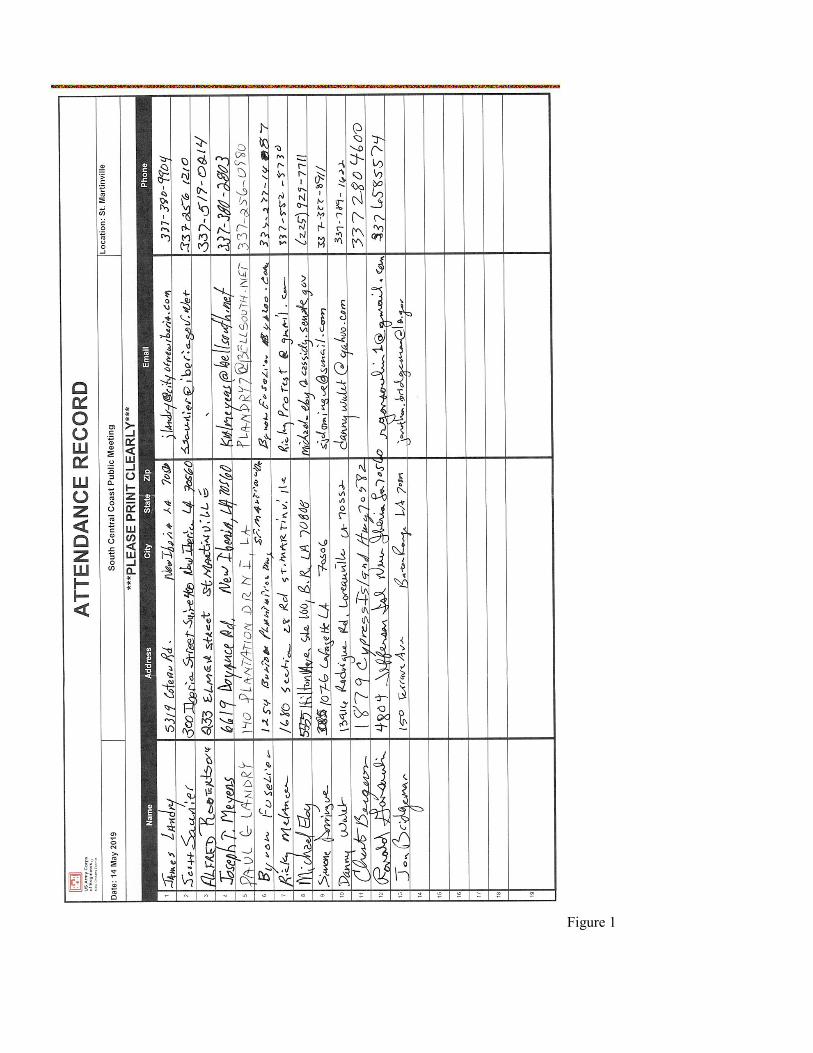
Figure 1
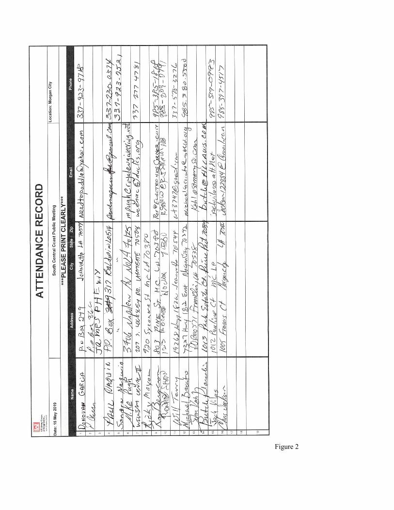
Figure 2

Figure 2


,. . f
1
2
3
4
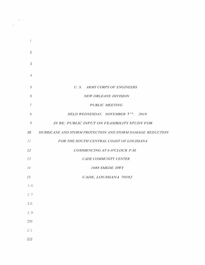
5 U. S. ARMY CORPS OF ENGINEERS
6 NEW ORLEANS DIVISION
7 PUBLIC MEETING
8 HELD WEDNESDAY, NOVEMBER 7 t h , 2018
9 IN RE: PUBLIC INPUT ON FEASIBILITY STUDY FOR
10 HURRICANE AND STORM PROTECTION AND STORM DAMAGE REDUCTION
11 FOR THE SOUTH CENTRAL COAST OF LOUISIANA
12 COMMENCING AT 6 O'CLOCK P.M.
13 CADE COMMUNITY CENTER
14 1688 SMEDE HWY
15 CADE, LOUISIANA 70582
16
17
18
19
20
21
22

23
24
25

, .
1 APPEARANCES:
2 Officer with the Corps ....................................................................... 3
3 Carla Sparks, Civilian Engineer
4
5
6
7
8
9
10
11
12
13
14
15
16
17
18
19
20

21
22
23
24
25
2

3
... .
1 I N D E X
2 Officer'S Opening Remarks ..............................3
3 CARLA SPARKS. ............................................................................................................. 5
4 OFFICER'S Closing Remarks ............................. 19
5 HAROLD SCHOEFFLER, with The Sierra Club ................................................... 22
6 TROY COMEAUX ............................................................................................................................... 25
7 MARTY TRAHAN, Councilman District 13 ............................................................ 29
8 BILL DUNCAN, businessman Port of Iberia .................................................. 30
9 WILMA SUPRA ........................................................................................................................... 34
10 HAROLD SCHOEFFLER ...................................................................................................... 37
11 TROY COMEAUX ................................................................................................................................ 3 6
12 BILL DUNCAN ................................................................................................................. 37
13 TROY CO?-1:EAUX ............................................................................................................................. 37
14 HAROLD SCHOEFFLER ..................................................................................................... 38
. . . . . . . . . . . . . . . . 39 15 BILL DUNCAN . . . . . . . . . . . . . . . . . . . . . . . . . . .
16
17
18
19
20
21
22
23
24
25

4
1 PROCEEDINGS:
2 (Meeting is caiied to order.)
3 OFFICER: Tonight is a two-part meeting . One is
4 we want to give you some information about the South
5 Central Coastal Louisiana Flood Protect ion Projec t. We
6 are going to key in on information that is needed before
7 any st udy or project takes off and we want to get your
8 feedback. There are many, many things we consider .
9 More often that not, nobody knows this area as
10 well as the people who live there. And quite often the
11 old saying is true. We don't know what we don' t know.
12 And so your input, your feedback will help really get
13 this started in the right direction.
14 So there are several ways to do this. We can
15 take the comments tonight and there are also several
16 other ways to submit your comments on the cards on the
17 table in the back. We are not necessarily asking you to
18 comment tonight, though we do appreciate if you do. We
19 have comment cards in the back. They are pre-postage
20 paid. So if you wanted to take it in a little and digest
21 it a little bit and let it sink in, you know, I can guess
22 you can have, and by all means, please you can do so. We
23 might not do as you are probably used to. We are not
24 setting a "Comments are due by 8:00 PM.) That will come
25 later. So right now there is kind of an opening mic and
6
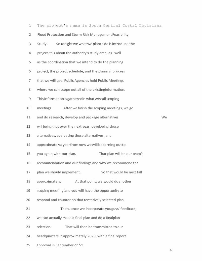
1 The project's name is South Central Costal Louisiana
2 Flood Protection and Storm Risk Management Feasibility
3 Study. So tonight we what we plan to do is introduce the
4 project, talk about the authority's study area, as well
5 as the coordination that we intend to do the planning
6 project, the project schedule, and the planning process
7 that we will use. Public Agencies hold Public Meetings
8 where we can scope out all of the existing information.
9 This information is gathered in what we call scoping
10 meetings. After we finish the scoping meetings, we go
11 and do research, develop and package alternatives. We
12 will being that over the next year, developing those
13 alternatives, eval uati ng those alternatives, and
14 approximately a year from now we will be corning out to
15 you again with our plan. That plan will be our team's
16 recommendation and our findings and why we recommend the
17 plan we should implement. So that would be next fall
18 approximately. At that point, we would do another
19 scoping meeting and you will have the opportunity to
20 respond and counter on that tentatively selected plan.
21 Then, once we incorporate you guys' feedback,
22 we can actually make a final plan and do a final plan
23 selection. That will then be transmitted to our
24 headquarters in approximately 2020, with a final report
25 approval in September of '21.
7
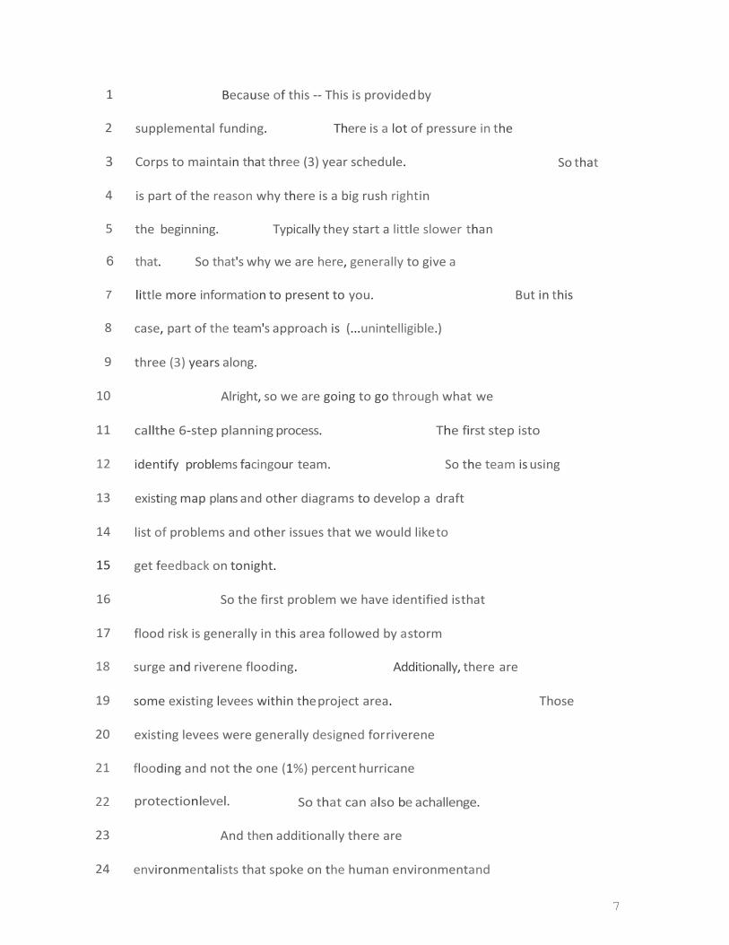
1 Because of this -- This is provided by
2 supplemental funding. There is a lot of pressure in the
3 Corps to maintain that three (3) year schedule. So that
4 is part of the reason why there is a big rush right in
5 the beginning. Typically they start a little slower than
6 that. So that's why we are here, generally to give a
7 little more information to present to you. But in this
8 case, part of the team's approach is (...unintelligible.)
9 three (3) years along.
10 Alright, so we are going to go through what we
11 call the 6-step planning process. The first step is to
12 identify problems facing our team. So the team is using
13 existing map plans and other diagrams to develop a draft
14 list of problems and other issues that we would like to
15 get feedback on tonight.
16 So the first problem we have identified is that
17 flood risk is generally in this area followed by a storm
18 surge and riverene flooding. Additionally, there are
19 some existing levees within the project area. Those
20 existing levees were generally designed for riverene
21 flooding and not the one (1%) percent hurricane
22 protection level. So that can also be a challenge.
23 And then additionally there are
24 environmentalists that spoke on the human environment and

8
25 the natural environment area. Within the project area,
9
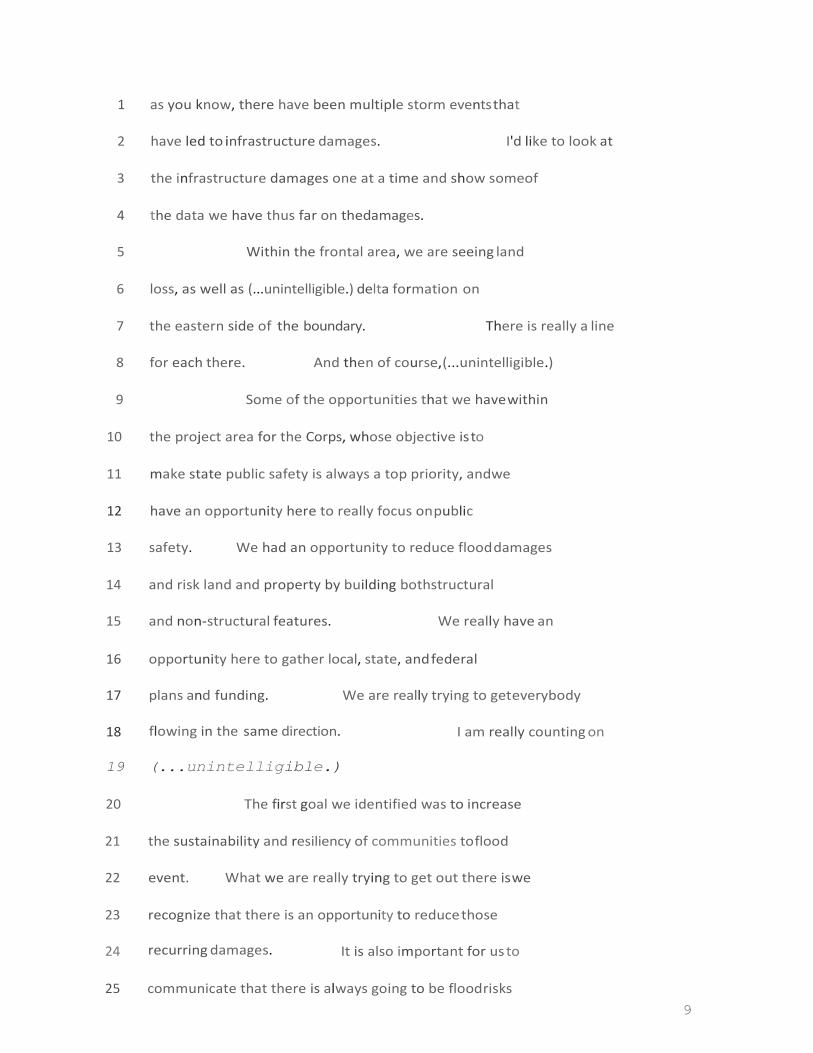
1 as you know, there have been multiple storm events that
2 have led to infrastructure damages. I'd like to look at
3 the infrastructure damages one at a time and show some of
4 the data we have thus far on the damages.
5 Within the frontal area, we are seeing land
6 loss, as well as (...unintelligible.) delta formation on
7 the eastern side of the boundary. There is really a line
8 for each there. And then of course, (...unintelligible.)
9 Some of the opportunities that we have within
10 the project area for the Corps, whose objective is to
11 make state public safety is always a top priority, and we
12 have an opportunity here to really focus on public
13 safety. We had an opportunity to reduce flood damages
14 and risk land and property by building both structural
15 and non-structural features. We really have an
16 opportunity here to gather local, state, and federal
17 plans and funding. We are really trying to get everybody
18 flowing in the same direction. I am really counting on
19 (...unintelligible.)
20 The first goal we identified was to increase
21 the sustainability and resiliency of communities to flood
22 event. What we are really trying to get out there is we
23 recognize that there is an opportunity to reduce those
24 recurring damages . It is also important for us to
25 communicate that there is always going to be flood risks
10
1 within these project areas. So we can't completely abate
2 that risk as a result of this project, but we certainly
3 can look to reduce it.
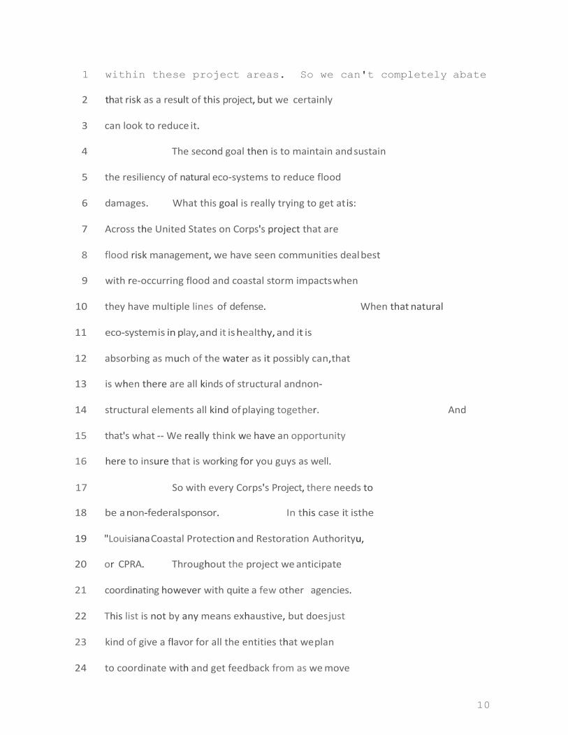
4 The second goal then is to maintain and sustain
5 the resiliency of natural eco-systems to reduce flood
6 damages . What this goal is really trying to get at is:
7 Across the United States on Corps's project that are
8 flood risk management, we have seen communities deal best
9 with re-occurring flood and coastal storm impacts when
10 they have multiple lines of defense. When that natural
11 eco-system is in play, and it is healthy, and it is
12 absorbing as much of the water as it possibly can, that
13 is when there are all kinds of structural and non-
14 structural elements all kind of playing together. And
15 that' s what -- We really think we have an opportunity
16 here to insure that is working for you guys as well.
17 So with every Corps's Project, there needs to
18 be a non-federal sponsor. In this case it is the
19 "Louisiana Coastal Protection and Restoration Authority u,
20 or CPRA. Throughout the project we anticipate
21 coordinating however with quite a few other agencies.
22 This list is not by any means exhaustive, but does just
23 kind of give a flavor for all the entities that we plan
24 to coordinate with and get feedback from as we move

11
25 through the process. Others would include FEMA, Natio nal
12
1 Marine & Fisheries Service, Louisiana State Homeland
2 Security, those folks. Additionally, within that project
3 area there is cargo interests, and so we will coordinate
4 with interested travel parties as well.
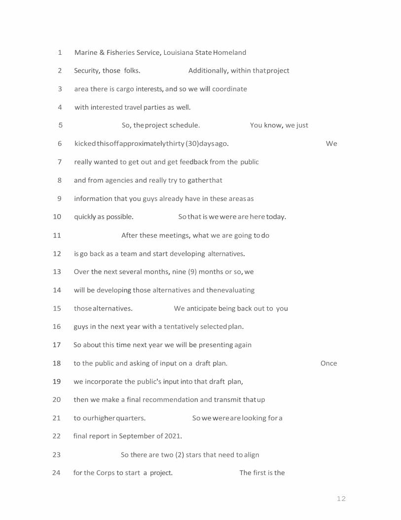
5 So, the project schedule. You know, we just
6 kicked this off approximately thirty (30) days ago. We
7 really wanted to get out and get feedback from the public
8 and from agencies and really try to gather that
9 information that you guys already have in these areas as
10 quickly as possible. So that is we were are here today.
11 After these meetings, what we are going to do
12 is go back as a team and start developing alternatives.
13 Over the next several months, nine (9) months or so, we
14 will be developing those alternatives and then evaluating
15 those alternatives . We anticipate being back out to you
16 guys in the next year with a tentatively selected plan.
17 So about this time next year we will be presenting again
18 to the public and asking of input on a draft plan. Once
19 we incorporate the public's input into that draft plan,
20 then we make a final recommendation and transmit that up
21 to our higher quarters. So we were are looking for a
22 final report in September of 2021.
23 So there are two (2) stars that need to align
24 for the Corps to start a project. The first is the

13
25 authority. For this project, we actually received the

14
1 authority back in 2006. Here, you can see -- I am going
2 to call your attention to this part here. (Indicating.)
3 That starts with "The Secretary of the Army is requested
4 to survey the coast of Louisiana in Iberia, St. Martin,
5 and St. Mary Parishes with a view to determine the
6 feasibility of providing hurricane protection and storm
7 damage reduction and related purposes." So the Secretary
8 of the Amy is the Corps of Engineers. Essentially , this
9 tells us what we need to study and where we need to study
10 it. I would note there was a name change. The original
11 authorizations said "Southeast Coastal Louisiana". There
12 is another study that also had a very similar name; so it
13 was changed to South Central Coastal Louisiana". So
14 that is the study authority.
15 We understand that Hwy 90 is an evacuation
16 route when a hurricane events. And we believe that
17 presents an opportunity for our project to extend that
18 coastal land and wetland loss and thereby reduce flood
19 risk damages.
20 So the second step in our plan process is to
21 inventory your existing conditions, meaning both the
22 natural land and the built-up land, and then forecast out
23 fifty (50) years into the future. So we will do for a
24 variety of things and we will show you some examples of

15
25 information that our team was gathered thus far.

16
1 Here, we have the storm surge elevation with
2 levees that aren't designed to elevatio n, so you can see
3 it. (Indicating.) What this is showing you is that
4 there is some protection that is also being provided from
5 storm surge. So the 11.5' there is the elevation of the
6 levee. These are really small (...unintelligible.) So
7 about a half a foot here would really help with storm
8 surge. You can see up here where you don't have flood
9 protection where it is come in. So this wasn't
10 specifically designed for coastal storm surge. It was
11 designed for riverene flooding.
12 In this diagram you can see just a little more
13 of the existing flood infrastructure. Here it is a
14 little bit more certain and shows the different levels
15 that are actually in place right now. And these little
16 "circleu areas are the existing pumps. So we are looking
17 at the existing pumping capacity, another level of
18 protection (... uni n t e l l i gi bl e . ) (Speaker moving around
19 and away from mic/podium throughout thus f ar . )
20 AUDIENCE MEMBER: Can you repeat that last
21 sentence? Starting back about the "circles.
22 CARLA SPARKS: Sure. The dots here are your
23 existing pumps.
24 AUDIENCE MEMBER: Pumps?
25 CARLA SPARKS: Pumps, yes. So part of what we
17
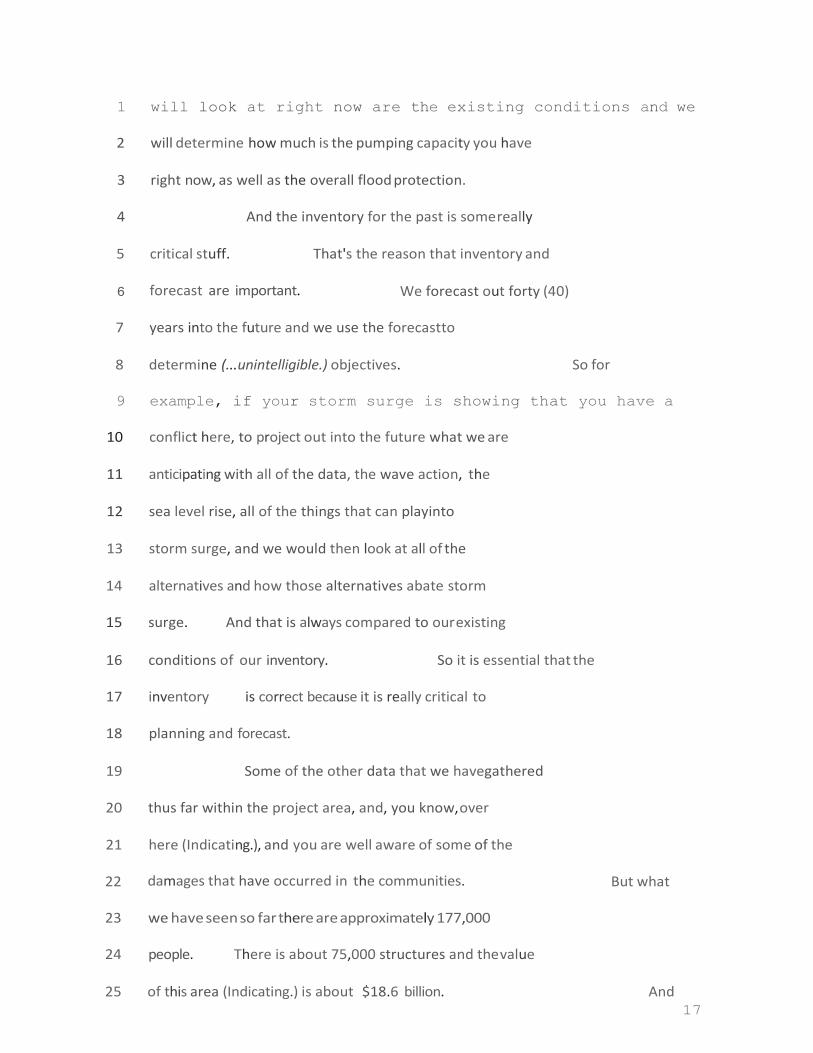
1 will look at right now are the existing conditions and we
2 will determine how much is the pumping capaci ty you have
3 right now, as well as the overall flood protection.
4 And the inventory for the past is some really
5 critical stuff. That's the reason that inventory and
6 forecast are important. We forecast out forty (40)
7 years into the future and we use the forecast to
8 determine (...unintelligible.) objectives. So for
9 example, if your storm surge is showing that you have a
10 conflict here, to project out into the future what we are
11 anticipating with all of the data, the wave action, the
12 sea level rise, all of the things that can play into
13 storm surge, and we would then look at all of the
14 alternatives and how those alternatives abate storm
15 surge. And that is always compared to our existing
16 conditions of our inventory. So it is essential that the
17 inventory is correct because it is really critical to
18 planning and forecast.
19 Some of the other data that we have gathered
20 thus far within the project area, and, you know, over
21 here (Indicati ng.), and you are well aware of some of the
22 damages that have occurred in the communities. But what
23 we have seen so far there are approximately 177,000
24 people. There is about 75,000 structures and the value
25 of this area (Indicating.) is about $18.6 billion. And

18
1 that breaks down to each parish. This is Iberia Parish
2 with approximately 72,000 folks living that area. The
3 approximate value is $7.8 billion. You see both
4 residential and non-residential structures here. Most of
5 those structures appear to be raised to up to two (2')
6 feet. And that is pretty common for all of the parishes
7 (...unintelligible.) This is St. Martin' s Paris h. You
8 have a value of approximately $5 million and 22,000
9 structures. And here's St. Mary' s Parish where there is
10 23,000 structures and a value assigned of
11 (...unintelligible.)
12 So in terms of some the damages that have been
13 incurred in these project areas, these are the
14 (...unintelligible.) and received the most damages.
15 These are just preliminary numbers where we know of the
16 hazard. We, right now, are going to evaluate this point;
17 but this just kind of gives you a sense of what we know
18 are minimal damages and how they occurred.
19 AUDIENCE MEMBER:
20 CARLA SPARKS:
Speak into the mic.
Is that better?
21 MEMBER: Much better.
22 CARLA SPARKS: So in Iberia Parish there has been a
23 total of $94 million in the last forty (40) years paid on
24 non-FEMA plans. What that represents, just to give you a

19
25 scale of this number, this is approximately We know

20
1 that this is the only looking at those individuals that
2 have flood insurance in the project area. Approximately
3 twenty (20%) percent of the people in the project area
4 have flood insurance. So we know that this number is
5 higher, but it is still valued at $94,000 million. The
6 figure in St. Martin's Parish over the last forty (40)
7 years has been about $19 million worth of damages. And
8 in St. Mary Parish we know that there has been at least
9 $31 million worth of damages.
10 Also in the study area, just looking at when
11 this -- a large percentage of the area is holding longer,
12 were already wetlands. It is about seventy (70%) percent
13 of the project area. The next largest land area where we
14 have in the study area is cultivating crops . And then we
15 have (...unintelligible.), mostly sugar cane in Iberia.
16 With each one of our projects we are required
17 what they call a "no action alternative". That ''no
18 action" requirement is essentially saying, "What would
19 happen to the human resources and the natural resources
20 in this area if nothing was done?" And that is, again,
21 projected over fifty (50) years.
22 So this isn't an all-inclusive list. These are
23 some of the things that we will look at that would
24 influence our future forecasting. We are conceding this
25 area has an increased flood risk due to sea level rise,

21
1 an there is an increased frequency and intensities of
2 storms. There is subsidence in some of the areas as well
3 as delta formations in the area. So that is going to
4 make a difference in terms of elevations between those.
5 So as we formulate for our actual alternatives,
6 we will have to consider a variety of things. So there
7 is always some constraint that we have to take into
8 account when we formulate our alternatives . These are
9 some of the ones that we anticipate having to take into
10 account on this project area. Certain
11 (...unintelligible .)
12 (...unintelligible.
loss. If we do structural Speaker has turned and moved away
13 from mic.) In this study, the appropriation for this
14 specifically (...unintelligible.) Originally, we had
15 hoped that we would be able to move forward toward
16 coastal restoration. Very similar to Southwest Coastal.
17 Many of you are familiar with that study. This project
18 authorization, or funding authorization, unfortunately
19 eliminated that (...unintelligible. Turning away fro mic
20 again.)
21 We will, of course, to consider any design
22 constraints for local infrastructure (...unintelligible.)
23 minimizing any transfer and avoiding a transfer risk to
24 any of the outlying communities. And if there is any

22
25 hazardous waste within the project area , we will have to
23
1 take that into consideration for our designs and
2 alternatives.
3 So we are really just scratching the surface of
4 getting and collecting all those data. Some of the
5 information we are going to be collecting and the where
6 we are thinking we can get that information from is
7 vital. What I would like to know is -- There is a few of
8 these that we would really like to come up with
9 (...unintelligible.) that we did work on.
10 We talked about earlier what communities have
11 experienced. So we really need your guidance and input
12 to help us focus in on the right areas.
13 Specifically we are looking at -- We looked and
14 there were flood damages from past storms
15 (...unintelligible. People next to me talking over the
16 speaker' s recording.) and where those damages were
17 occurring. That would be very helpful to us. We also
18 would like to know there are additional commercial or
19 industrial facilities in the project area that are
20 partnered for master plans for things that you know we
21 need to have (...unintelligible. People next to me
22 talking again.) over the next couple of years. And we'd
23 really like to know that information as well so that we
24 don' t propose anything that would potentially impact
25 those projects. So if anything that is going to affect

24
1 the design or work, we need to know that now. So that is
2 just a look at how we formulate out plans.
3 Our project sponsor, CPRA, funded a study
4 through Arcadis that we intend to use in this project and
5 we will look at it. That study was largely structural,
6 so we will certainly look at that as an alternative.
7 Additionally, we will look at non-structural
8 alternatives, and any combination thereof. We will also
9 look at a few ways of capturing and focusing in on those
10 damage areas and where we really need to get a handle on
11 how to best provide these communities to protect them.
12 So many of you are familiar with non-structural
13 alternatives. Generally I think what comes to most
14 people' s mind is voluntary buy-outs, structural raises.
15 But there is also other things that we can consider like
16 evacuation planning, what wet-proofing and dry-proofing
17 and those types of things. And so we will consider all
18 of those things for this project on the table.
19 So once we have our alternatives kind of
20 packaged, then we have to evaluate and compare them to
21 one another to really see where we are getting the best
22 bang for our buck. And so we are interested in hearing
23 from you if there is anything that you would like us to
24 eval uate , any kind of valuation criteria . But the

25
25 criteria that I have here on the slides are just some of

26
1 those kind of general criteria that we are required to
2 look at the Corps Of Engineers. So we always look at
3 average annual damages reduction, reduction of risk to
4 life loss, reduction in the primary costs. Those costs
5 would include any mitigation costs as well as full
6 operation and maintenance costs over the project life
7 cycle. So that would be over the fifty (50) years and
8 that would all be included in those packages.
9 So once we have our alternative packages
10 developed, then we will have to evaluate and compare them
11 to one another to really see where we are getting the
12 best bang for our buck. And so we are interested in
13 hearing from you if there is anything that you would like
14 us to evaluate, any kind of valuation criteria. But the
15 criteria that I have here on the slides are just some of
16 those kind of general criteria that we are required to
17 look at the Corps Of Engineers. So we always look at
18 average annual damages reduction, reduction of risk to
19 life loss, reduction in the primary costs based on flood
20 frequencies. But first, we look at costs.
21 Another thing we need to explain and about in terms
22 of costs: Those costs would include any mitigation costs
23 as well as full operation and maintenance costs over the
24 project life cycle. So that would be over the fifty (50)
25 years and that would all be included in those packages.
27
1 So what we really need from you folks: We
2 really would like some input tonight on our draft
3 problems and opportunities to better understand are we
4 capturing those problems and opportunities that are
5 within the project area? Are there additional problems
6 that we need to add? What flood event did your community
7 see the most damages? And was that flood event storm
8 surge? Was it riverene flooding? Was it back-water
9 flooding? What type of flooding was that? Are there
10 alternative strategies that would better address the
11 problems that we have in the project area? Are there
12 additional constraints in our future developme nt or
13 things that we should consider as we are developing
14 alternatives? And finally, is there any data or studies
15 that the project team should know about and information
16 that we can use so that we don't have to re-create the
17 way and hopefully move a little faster in this project?
18 We'd really appreciate that.
19 So we don' t have a formal comment like "ending
20 period", which is probably not as familiar for folks.
21 We are currently accepting public comments. At
22 some point in the future, we will put out a formal nebo
23 scoping request and then give a final date for comments
24 in this initial phase. And we will make sure you guys

28
25 are all notified of that.
29
1 But if you do have public comments, we can
2 either take them tonight, we do have cards that you can
3 send in later, and/or you can write down the Project
4 Manager, Carrie Schott. And you can send your public
5 comments to her. And now we will accept public comments
6 tonight.
7 I'd like to say thank you for coming out
8 tonight. We really appreciate it. And we look forward
9 to hearing from you.
10 OFFICER: I'd like to take over and then say
11 thanks to Carla Sparks. We also have Joe Latore
12 (phonetically) in the back, the man from Rock Island
13 (...unintelligible. Speaker is not using the mic at this
14 time.)
15 There is a couple of things before we get into
16 comments that have been stressed. First is, you know,
17 when we are looking at -- kind of coming to us as
18 (...unintelligible.) As you all know, within
19 (...unintelligible.) we have to have a finance division
20 and a (...unintelligible.) In other words, whatever
21 damages there are, the word I am hearing is the cost of,
22 when we are reducing damages, has to be
23 (...unintelligible.) So what that means is, whatever it
24 takes to implement and maintain, must be considered with

30
25 the amount of damages reduced.

31
1
2 With that, we welcome your comments. Would you
3 speak into microphone. The reason why is we have a court
4 reporter and want to capture your comments.
5 HAROLD SCHOEFFLER: Harold Schoeffler with the
6 Sierra Club in Lafayette. This is the area I lived in and
7 fished in all my life. I know all of these waterways
8 and have used them.
9 When you speak in terms of storm surge
10 protection, the first thing that comes to is the Pointe
11 Au Fer reef. From Pointe Au Fer, the south point, it is
12 roughly thirty-three (33) miles and roughly three (3)
13 miles wide. It is supposed to be one of the biggest
14 natural shell reefs on earth. I was very involved in the
15 legal effort to stop the removal of that system.
16 But first, let me address this hydrologists
17 from the University of Florida. He said that removal of
18 the reef is such a threat from the area from Bayou
19 Lafourche to the Calcasieu that its impact should be done
20 on an emergency basis computer model to show how much
21 higher the storm surge would be expected in that region.
22 In his testament, it was eight (8') feet higher. And he
23 was expressing this announcement at a news conference at
24 the Point of Iberia. As he was giving his report from

32
25 the floor, one of the reporters asked, "How deep would it

33
1 be at the Port?ll And he put his hand over the door in
2 the conference room and said, "It would be about eight
3 (8'') inches over this door.u He missed by a mere inch.
4 It was nine (9") inches. And his intention was that that
5 could possibly be destroyed and there was more protection
6 with the levees.
7 Items like Shell Keys Wildlife & Refuge, the
8 defender of the wetlands, was (...unintelligible.) was
9 out the water and was about two (2) miles long and about
10 one hundred (100) yards wide, and had an elevatio n of
11 about six (6') feet above sea level. They dredged one
12 hundred (100) yards from it thirty (30') feet deep
13 removing shells. And of course the big waves came and
14 the whole Shell Keys Refuge ended up destroyed.
15 The same thing happened at Eugene Island. It
16 was a white shell reef. And the Rabbit Island. All of
17 those were destroyed. Rabbit Island was about one
18 hundred (100) acres and had reef all over it. They
19 removed the shell reefs south of it, and in a year it was
20 all gone. The story of that reef and the abatement of
21 that land, and (...unintelligible.)
22 When we took a storm surge in Iberia Parish it
23 only affects the area mostly south of Hwy 90 from
24 Delcambre to New Iberia. (...unintelligible.) from

34
25 Jeanerette in St. Mary Parish to the Baldwin Canal is the

35
1 area very affected . The rest is pretty much covered with
2 levees at one point or another all the way through St.
3 Mary Parish. The Bayou Sale reef, that system typically
4 was inundated by storm surge. Now they have put pumps,
5 so that is a big help.
6 The riverene impacts on this area, for the most
7 part, was this area from (...unintelligible.) St. Martin
8 Parish and lower St. Martin Parish. I don' t think the
9 storm surge hit the upper part of St. Martin at all.
10 We are threatened by flooding post-Katrina in
11 '16. There was lots of flooding in New Iberia and St.
12 Martin Parish flooding. I just wanted you to consider
13 the wave environment out there.
14 The enormous oilfields that have wells and rigs
15 left behind, that is quite a hazard or is about to be.
16 Water quality issues. Basically they have gone done
17 quickly. The "low o xu (low oxygen) in the water from the
18 swamps and the Gulf ended up killing oysters and clams.
19 And that impacts the whole eco-system, the marshes and
20 all of that included.
21 We will send in written complaint of these
22 claims that we think are the fault and possible ways to
23 resolve this.
24 We thank you all for putting this together. I
25 think it is really important to our area of Acadiana to
36
1 give us some good direction in surviving big flood events
2 and big hurricane events.
3 OFFICER: Thank you. Thank you very much, sir.
4 We always look at that and give you feedback and rely on
5 the feedback you give us. We will be respo nding to you
6 through that mail.
7 Anybody else?
8 TROY COMEAUX: Troy Comeaux from New Iberia.
9 In addition to the storm surge that he was just
10 commenting on, we have other people who are people in
11 Iberia Parish that are also concerned about this day-to-
12 day flood control. Due to many of the factors I am sure
13 were just stated, just on a day when we get three (3) or
14 four (4) hours of south wind, the water is penetrating so
15 far up north into our drainage system. A rain event like
16 today, at high tide with a south wind, it will shut down
17 7 the Port of Iberia .
18 So when we talk about economic development , it
19 is the impact that, not only responds to a storm surge,
20 but just a rainy day with a south wind at high tide. I
21 mean look at, look at -- Please consider how that impacts
22 the Hwy 90 south and the industry that
23 (...unintelligible.) and all of the coastal area. So
24 that's important to us as well. We have been fortunate
25 to dodge a few bullets with some hurricanes that have

37
1 come our way in Iberia for quite some time. But our
2 businesses are struggling along that Hwy 90 because the
3 rainwater has no place to go. It is just stacking up
4 near Hwy 90 and (...unintelligible.).
5 OFFICER: And just for my clarification, you
6 are looking at, you are looking at torrential rain as
7 well as basically the winds stacking the water up through
8 this area.
9 TROY COMEAUX: I belie ve, and I might have some
10 -- a little bit of input or encouragement. I think our
11 drainage system was built at an elevation in relationship
12 to Vermillion Bay and Weeks Bay. When that rises, it is
13 two (2 ' ) (feet) or three (3 ' ) feet above our drainage
14 system going south. So yeah, the water is stacking up.
15 It is going under Hwy 90 into the city of New Iberia.
16 What is happening in addition to just the Port
17 of Iberia, it is also creating flood maps to expand
18 mandatory flood insurance. So it is having a continuing
19 impact on our real estate industry and those people where
20 there are ma ndates . People cannot afford, or hope to
21 afford, property. I passed on some property myself
22 because they couldn't give me a quote on what the flood
23 insurance would be until I owned the property. That is
24 happening in multiples and is affecting our industry. It

38
25 is affecting our real estate industry and our
39
1 agricultural industry. So we are very involved, and not
2 with just the storm surge.
3 OFFICER: Thank you, sir. Absolutely. And one
4 of the challenges that we are going to have with this, in
5 looking at it, you have to model it to understand the
6 causes for all flooding. Then maybe we can see what
7 this hearing here is bringing to us and what is actually
8 happening with drainage issues. And I will say that, no
9 matter what we do, we can't really do any drainage work
10 anywhere, although the information is valuable overall.
11 But the authorization is for surge and riverene based
12 flooding. So it is something that we'11 have to look to
13 understand .
14 We get to come back out to you guys and kind of
15 see what we are looking at, and you let us know in
16 feedback.
17 TROY COMEAUX: When you speak about rivere ne
18 flooding, you are talking about over time type flooding?
19 OFFICER: And like the backwater flooding area where
20 it is coming basically north of the Atchafalaya River in
21 the Basin. That we will be able to look at, including
22 the force of the surge and the water coming in.
23 Rain would be something you'd have to
24 understand (...unintelligible.) is a Parish issue.

40
25 TROY COMEAUX: Yeah. My point to that is: Obviously

41
1 you can't address the area of the drainage issue. I
2 understand that in every community. My point is is that
3 the economy says it is the barriers that were destroyed,
4 there is a lot of salt water intrusion, which impedes
5 with the rainwater, from having a place to go. We have a
6 commercial canal that comes right up through to the Port
7 of Iberia on one of the main thoroughfares of the City of
8 New Iberia. It a commercial canal. And it goes all the
9 way into the middle of the town. A lot of this is not
10 culverted and underground, but it goes all the way into
11 the city and directly into the Port of Iberia. Since the
12 barriers have been destroyed, as was well-often
13 explained, the intrusion of salt water penetration corning
14 to t he north is affecting a lot more industry than what
15 we might necessarily get. We need to get a lobbyist's
16 reaction to this or a feel for it. It is not just a
17 coastal thing. It is corning into and affecting the
18 community.
19 OFF ICER : Is it some sort of chain reaction?
20 TROY COMEAUX: Correct. Because the FEMA flood
21 maps are growing with higher flood insurance rates are
22 growing, the cost of living is growing . The real estate
23 industry is suffering. The crops are suffering because
24 of the infiltration and for many other reasons that Mr.

42
25 Schoeffler just spoke about.

43
1 OFFICER: Thank you.
2 Yes, sir?
3
4 Council.
MARTY TRAHAN: Yes, Marty Trahan, Iberia Parish
I represent District 13. Corning up from the
5 Declarnbre area , like Mr. Schoef fler said, the Poi nt au
6 Fer reef, I remember that as a kid when Shell Keys was
7 sticking way up out the water. Okay?
8 (...unintelligible.) felt the surge corning in when it is
9 high tide. Because if you come up to Delcambre, you come
10 up to Lake Peigneur and you have pumps A and Ball
11 draining into that basin right there right on the west
12 side of the South Central Study. Okay? That is another
13 point we' ve got to look at. That goes back all the way
14 into Lafayette, Youngsville, Broussard, Lafayette . That
15 all has to drain back into there.
16 In fact that phone call that went off a while
17 ago, is a Hwy 90 business that is, just with the rain we
18 had today, and we had a massive amount of rainfall, they
19 are about to get water into their businesses. Okay? So
20 we are looking at the drainage canal being dug out to
21 (...unintelligible. His voice is trailing off.) you
22 know, some other places. And we are working on that
23 drainage. I think it needs to be looked on the most west
24 part of it. Like Mr. Schoeffler said, it is going back

44
25 into Lafayette. We get this from rain events, not no

45
1 sto rm surge.
2
3 are lo w.
TR OY CO ME AUX : Right. Especially if the tides If it is high
tide, a high tide will bring
4 (...unintelligible.) from what I saw. This is the fourth
5 (4th) time we' ve seen this flooding of businesses since 6 2016.
7 OFFICER: Thank you very much.
8 BILL DUNCAN: My name is Bill Duncan. I have
9 a business at the Port of Iberia. I have been there
10 nineteen (19) years and I have been flooded about three
11 (3) times.
12 When I first bought the business, I paid
13 probably about $8,000 a year for flood insurance and FEMA
14 did provide and rebuild for me. I used the money as best
15 I could to rebuild my business, but also do things for in
16 the future if I had another flood event and I could get
17 my equipment out and so on and so forth.
18 What has happened to a lot of businesses in our
19 area is that my flood insurance went up the next year
20 twenty-five (25%) percent. I think it went up to
21 $12,000. This last year it went to $19,000 with a
22 $20,000 deductible. And with the down-turn in the
23 industry, the oil industry, happening in this area, at
24 least at the Port, I couldn't afford flood insurance. I
25 think that is what has happened to a lot of communities.
46
1 In Broussard, an area that was never in a flood
2 plain, due to the fact everything you have said in
3 defense of tidal surges, it keeps the drains from going
4 o ut . It has put everybody in Broussard, in Youngsville
5 that are now in flood plain areas now, that they are not
6 meeting their needs. The bank requires them to have
7 flood insurance that is going up faster than they can pay
8 off their house and get out of there. This is the large
9 thing with people from Youngsville too. And all I have
10 ever been told, we have some areas where the entire
11 subdivision is now in a flood plain, but they have a 30-
12 year mortgage and they are being required to pay for
13 flood insurance that is going up so quick. You know, it
14 might be $2,000-something a year, or something like. But
15 for my business, I can' t even survive, you know, being
16 there.
17 Y'all are welcome to the Port of Iberia
18 tomorrow. I have a business that provides food and
19 services to support the Port. But what I' m kind of
20 seeing from the studies, what all y'all claim to propose
21 is about a 5-year plan. You said three (3) years. But
22 none of this is even put out to bid yet. And with that,
23 we need help now. We need -- Just like Parish Council
24 Member said, that is happening on a more and more regular
25 basis and we are having just like this year -- I think
47
1 this winter we are expecting a harsher winter weather
2 according to Service. Which means, you know, if we have
3 a higher than normal surge and we have a lot of rain,
4 everybody is vulnerable. And I really the sense of
5 urgency, if there was a lot of people here tonight, they
6 would say that the government is moving too slowly with,
7 with, what we need help from.
8 On that, we are going -- all these gentlemen
9 here with the Port and whatever, the Levee District, we
10 can' t afford our levees because our economy is so far
11 down and over-taxed, we can't build levees and we can't
12 put structures in. And one of the main things that was
13 told to us by the Parish why they didn't pass the levee
14 tax was that the federal government needs to be a bigger
15 part of this.
16 And my whole thing is, if you look at what they
17 have done to the east of us, is, is down in Thibodaux and
18 these places, that is valuable and protecting those
19 people with the structures and pump stations and things
20 like that. But it also takes into consideration of the
21 eco-system that allows the water to come and go as it
22 needs to be to take care of estuaries and keep on
23 surviving.
24 So to me, it seems like all of this information

48
25 you already have available. It needs to be fine-tuned

49
1 some more, but if you' ve got to five (5) years to six (6)
2 years to study, and by the time you get the structures
3 put in place, or whatever is needs, even dredging the
4 Verm illio n River and thing s li ke that, and I think it is
5 their plans, by that time my business won' t be there.
6 Thank you.
7 OFFICER: And (...unintelligible. Speaker has
8 no m ic.)
9 MARTY TRAHAN: Marty Trahan, again. What I see
10 needs to happen is for it to be a regional, Iberia,
11 Vermillio n, St. La ndry, Lafayette , St. Martin, St. Mary ,
12 and expand it a little more what drains into us. The
13 Parish Presidents, the whole of the Presidents needs to
14 get a hold of this, and do a study on it. We have
15 (...unintelligible.) now; but we are also going to need
16 the federals to come on. I think it needs to be a
17 combined effort of everybody and see what needs to happen
18 and at what speed it can happen.
19 Where I live is four (4) miles -- Well,
20 Petitance is about three (3) from my house. The Avery is
21 about four (4) miles. And for RITA. It came up to my
22 door of my house. It didn't get into my house, but it
23 co ntin ued to the door . So I know the next time I am
24 flooded . I am going to loose my house. Okay? But I
25 really think this needs to go regional and have the input
35
1 City/Berwick/Bayou Vista of St. Mary Parish. We have
2 lived in Iberia Parish for fifty-three (53) years, and we
3 are property owners here in St. Martin Parish. So all
4 three (3) of the parishes focused on, we are involved in
5 things that are going on.
6 When you did the presentation you identified
7 flooding as a result of storm surges, as well as river
8 flooding. A lot of the same areas are flooded as a
9 result of those two (2) impacts; but there are different
10 perspectives and different methods that you are going to
11 have to look at dealing with storm surge versus river
12 flooding.
13 You also identified wanting to make sure that
14 Hwy 90/I-49 was accessible for evacuations. In the
15 Billeaud exit off of Hwy 90, that one goes under every
16 time we have a storm surge, as well as around Coteau.
17 Even though Coteau in Iberia and St. Martin Parish is a
18 ridge, the highway there goes underwater. And right up
19 here as (LA) 92 crosses both 182 and 90, those areas
20 flood. So we can't even keep the highways open now.
21 What is going to happen further down the road?
22 The other aspect is that Chapin Minlen, LLC
23 (phonetically) did the study -- did a map and study of
24 where the open water from the coast would be in fifty

36
25 (50) years and in one hundred (100) years. The fifty

37
1 (50) year one was in 2030 or 2033.
2 An individual, who was a technical person from
3 the experimental farm in Iberia Parish, went and did the
4 elevations of storm surge after KATRINA/RITA. All of
5 that mapping showed that the open waters in fifty (50)
6 years that Chapin had projected as flooded as a result of
7 KATRINA/RITA. So when you start looking at what are you
8 going to do to protect both the estuaries and the people
9 from the flooding, you have to remember that a lot of
10 that land is going to be underwater within the time you
11 are going to be doing the planning. So please take that
12 into consideration and actually plan for what will be
13 conditions as we move forward.
14 Thank you.
15 OFFICER: Absolutely. Thank you very much.
16 Do you have any -- If I can get to anybody who
17 hasn' t spoken yet and then we will get back to you guys
18 who already have. So anyone who hasn't spoken want to
19 speak?
20 (None indicated.)
21 HAROLD SCHOEFFLER: In relation to the higher
22 tide levels, when Dr. Christiansen was here, he pointed
23 out the Point au fer reef, in its natural structure , had
24 a channel capacity about the same as Southwest Pass,
25 roughly about sixty thousand (60,000') feet. Now it is

38
1 over 2 million square feet. That's why the salinity is
2 high and storm surge is weak. These tide surges are much
3 quicker and much higher. If you would restore that, you
4 would reduce significantly the level that it comes and
5 how high it was and the salinity level would be lower.
6 OFFICER: Thank you very much, sir.
7 MARTY TRAHAN: Just one more point here?
8 (Indicating.)
9 OFFICER: Absolutely.
10 TROY COMEAUX: Troy Comeaux from New Iberia.
11 We are also concerned about the plans that St. Mary has
12 that deals with their part of the coastal master plan
13 levee and how that is going to affect a storm to the east
14 of us in Iberia and how that water is going to be blocked
15 in Terrebo nne and Lafourche and St. Mary and how it is
16 going to affect that extra water that is not going them.
17 It going to come to New Iberia.
18 OFFICER : Yeah. You know, there is a
19 difference there we will have consider. Even if it is a
20 localized plans, we need to study the impacts of it as we
21 are moving forward. Our meeting next will be in St. Mary
22 Parish, the same as we have had with Iberia Parish and
23 St. Martin Parish.
24 MR. DUN CAN : We are extremely fearful that
25 Amelia and then Iberia will be defunct.

39
1 OFF ICER : Right now I would say I have
2 confidence on the federal side and they will consider
3 that and the reduced flooding component. But we do have
4 to consider what the locals are planning on their own as
5 well.
6 TROY COMEAUX: Even if Hwy 90 at (LA) 329 Avery
7 Island Road, my house is exactly three (3) miles to the
8 Hwy 14 and I had water past my house up the Lewis Street
9 Road. So you are talking 90 as a corridor to get out?
10 In years to come, (HWY) 90 will not be there at all to
11 get out.
12 OFFICER: That is definitely something that we
13 always say we can' t run the risk. So they have never
14 elimina ted evac uations from the plans ....................................... unintelligible.
15 Moves away from the mic.) I am just saying that Point au
16 Fer is in the master plan as well. I think some you have
17 had a discussion between yourselves of that.
18 HAROLD SCHOEFFLER: It is a proposed project.
19 I don' t know where it ranks in being done; but Dr. Lynn
20 Barr and Dr. Paul Ken, I have been hearing all three (3)
21 agree that that would be a very significant protective
22 feat. It would build up more than levees and protect a
23 much larger area all the way from the Calcasieu to Bayou
24 Lafourche.

40
25 BILL DUNCAN: I think living here all our

41
1 lives, what we have seen , and if you have be en here since
2 childhood, you can always remember there was flooding of
3 some types in some certain areas; but not as wide an area
4 when we have a storm surge. And just like they are
5 saying about these reefs and these areas that -- If you
6 could point to the Marsh Island with your pointer? Where
7 the line goes through? (Complies.) That is basically a
8 choke point that Mr. Schoeffler was talking about that at
9 one time really slowed down storm surge coming to the
10 north. And these reefs were the protection that we had
11 that slowed down the storm surges. You might have had
12 flooding, but it took longer for the water to go through
13 these passes and choke points. And basically, that is a
14 natural protection that everybody understands that was
15 there years and years ago.
16 You know, the point is: Now that those are not
17 there, the storm surge comes a lot faster and it hits a
18 lot bigger area a lot quicker and the water stays. Once
19 it packs up into the marshes and then all the way into
20 the canals and areas, it takes that much longer to go
21 back out. And goes back out -- Each time it goes back
22 out, it opens up an even wider path because of the
23 erosion that it is doing to the reefs and the choke
24 points that are natural.
25 OFFICER: Do we have anyone else?
24
25
40
1 (All indicate "no".)
2 OFFICER: If possible, I think I am going to go
3 ahead and close the meeting. Our RPM's and our planners
4 will be here if you want to discuss anything with them.
5 We are going to stick around for a little while and break
6 it down. But if it is okay with you guys, I' ll go ahead
7 and close the meeting itself.
8 Thank you very much. Thank you very much for
9 your comments and your insight. It will prove greatly
10 valuable to us as we move forward in a very expedited
11 manner.
12 Thank you all very much for coming out. I
13 appreciate it.
14 (RE PORTER ' S NOTE : For the next hearing, this needs to be
15 held in a smaller meeting room. The auditorium was much
16 too large and the sound quality was greatly diminished in
17 spite of the latest in audio equipment.)
18 * * * * * * 19
20
21
22
23
24
25
41
•77 ·
1 STATE OF LOUISIANA (Rev. 1/1/2013)
2 PARISH OF ST MARY
3 REPORTER'S CERTIFICATE
4 I, ELIZABETH RHODES McCL EARY, Official Court
5 Reporter for the 16th Judicial District Court, Parishes of St. Mary, Iberia, and St. Martin, of the State of
6 Louisiana, employed as a court reporter for the 16t h
7 Judicial District Court, State of Louisia na, as the
8 officer before whom this testimony was taken, do hereby certify that this testimony was reported by me was
9 prepared and transcribed by me or under my direction and
10 supervision, and is a true and correct transcript to the
11 best of my ability and understanding, that the transcript has been prepared in compliance with the transcript
12 format guidelines required by statute or by the rules of
13 the board or by the Supreme Court of Louisiana and the
14 Federal Rules, and that I am not related to counsel or to the parties herein, nor am I otherwise interested in the
15 outcome of this matter.
16 This certificate is valid only for a transcript
17 accompanied by my original signature and official required seal on this page.
18 IN WITNESS WHEREOF, I have affixed my official
19 signature this 2 8th day of August, 2018 at Patterson, St.
• Mary Parish , Louisiana .
• /signed/
• Elizabeth Rhodes McCleary, #91325 22 Official Court Reporter 23 16th Judicial District Court

24
25
42
r
1
2
3
4
5 U.S. ARMY CORPS OF ENGINEERS
6 NEW ORLEANS DIVISION
7 PUBLIC MEETING
8 HELD THURSDAY, NOVEMBER 8 t h
, 2018
9 IN RE: PUBLIC INPUT ON FEASIBILITY STUDY FOR
10 HURRICANE AND STORM PROTECTION AND STORM DAMAGE REDUCTION
11 FOR THE SOUTH CENTRAL COAST OF LOUISIANA
12 COMMENCING AT 6 O'CLOCK P.M.
13 MORGAN CITY MUNICIPAL AUDITORIUM
14 728 MYRTLE STREET
15 MORGAN CITY, LA 70380 16
17
18
19
20
21
22

24
25
43
23 24
25

19
20
21
22
23
24
25
2
1 APPEARANCES:
2 Officer with the Corps ........................................................................ 3
3 Carla Sparks, Civilia n Engineer
4 John Lombardo, Aide with Congressman Graves
5 Michael Brocato, SMLD
6 Monica Mancuso, Ph.D.
7
8
9
10
11
12
13
14
15
16

19
20
21
22
23
24
25
3
17
18
19
20
21
22
23
24
25
4
1 I N D E X Opening Remarks ............................. 3
2 JOHN LOMBARDO, Aide to Congressman
3 Graves ....................................................................... 20
4 MONICA MANCUSO, Ph.D .................. 22
5 MICHAEL
BROCATO,
with SMLD.ORG........ 23
6
7
8
9
10
11
12
13
14
15
16
17
18

1 PROCEEDINGS:
2 (Meeting is called to order.)
3 OFFICER: Tonight is a two-part meeting. One is
4 we want to give you some information about the South
5 Central Coastal Louisiana flood Protection Project. We
6 are going to key in on information that is needed before
7 any study or project takes off and we want to get your
8 feedback. More often that not, nobody knows this area as
9 well as the people who live there . And so your input,
10 your feedback will help really get this started in the
11 right direction.
12 There are several ways to do this. We can take
13 the comments tonight and there are also several other
14 ways to submit your comments on the cards on the table in
15 the back. We are not necessarily asking you to comment
16 tonight, though we do appreciate if you do. We have
17 comment cards in the back. They are pre-postage paid.
18 So if you wanted to take it in a little and let it sink
19 in, you know, you can do that and send in it, or your can
2 0 make comments. By all means, please you can do so.
21 (...unintelligible. Moving away from the mic.)
22 Right now is kind of an opening time period
23 where we want to get out as much information as we
24 poss ib ly we can . We will make an announcement later on
25 after have established the collected information. So we

4

5
1 will take comments from today until next time.
2 But if I can, I will turn my pointer over to
3 Carla Sparks and she will be able to kind of give you
4 what we do. Our steps and processes may be a little
5 different than what you are used to from our traditional
6 way (...unintelligible.) time. So we will give a little
7 bit of data and what you know about the area.
8 At this time I turn the meeting over to Carla
9 Sparks.
10 CARLA SPARKS: My name is Carla Sparks. I am the 11 Corps's rep and I am soon to be the plan formulator on
12 this project. We thank you for corning out tonight. We
13 know the weather is bad.
14 The project's name is South Central Costal
15 Louisiana Flood Protection and Storm Risk Management
16 Feasibility Study. So tonight we what we plan to do is
17 introduce the project, talk about the authority's study
18 area, as well as the coordination that we intend to do
19 the planning project, the project schedule , and the
20 planning process that we will use.
21 So the two (2) stars that need to align for the
22 Corps to start a project, the first is the authority.
23 For this project, we actually received the authority back
24 in 2006. Here, you can see -- I am going to call your
25 attention to this part here. (Indicating.) That starts
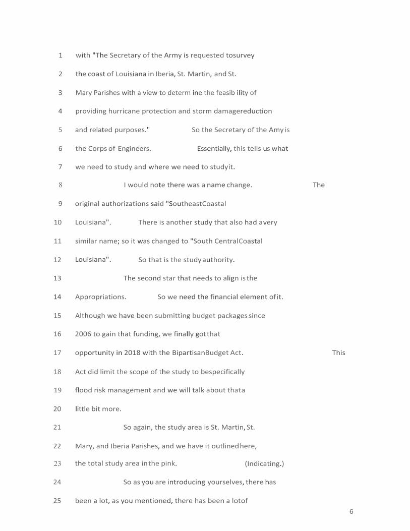
6
1 with "The Secretary of the Army is requested to survey
2 the coast of Louisiana in Iberia, St. Martin , and St.
3 Mary Parishes with a view to determ ine the feasib ility of
4 providing hurricane protection and storm damage reduction
5 and related purposes." So the Secretary of the Amy is
6 the Corps of Engineers. Essentially, this tells us what
7 we need to study and where we need to study it.
8 I would note there was a name change. The
9 original authorizations said "Southeast Coastal
10 Louisiana". There is another study that also had a very
11 similar name; so it was changed to "South Central Coastal
12 Louisiana". So that is the study authority.
13 The second star that needs to align is the
14 Appropriations. So we need the financial element of it.
15 Although we have been submitting budget packages since
16 2006 to gain that funding, we finally got that
17 opportunity in 2018 with the Bipartisan Budget Act. This
18 Act did limit the scope of the study to be specifically
19 flood risk management and we will talk about that a
20 little bit more.
21 So again, the study area is St. Martin, St.
22 Mary, and Iberia Parishes, and we have it outlined here,
23 the total study area in the pink. (Indicating.)
24 So as you are introducing yourselves , there has
25 been a lot, as you mentioned, there has been a lot of
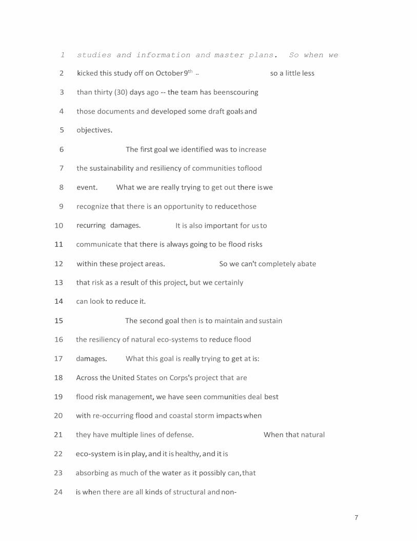
7
1 studies and information and master plans. So when we
2 kicked this study off on October 9th -- so a little less
3 than thirty (30) days ago -- the team has been scouring
4 those documents and developed some draft goals and
5 objectives.
6 The first goal we identified was to increase
7 the sustainability and resiliency of communities to flood
8 event. What we are really trying to get out there is we
9 recognize that there is an opportunity to reduce those
10 recurring damages. It is also important for us to
11 communicate that there is always going to be flood risks
12 within these project areas. So we can't completely abate
13 that risk as a result of this project, but we certainly
14 can look to reduce it.
15 The second goal then is to maintain and sustain
16 the resiliency of natural eco-systems to reduce flood
17 damages. What this goal is really trying to get at is:
18 Across the United States on Corps's project that are
19 flood risk management, we have seen communities deal best
20 with re-occurring flood and coastal storm impacts when
21 they have multiple lines of defense. When that natural
22 eco-system is in play, and it is healthy, and it is
23 absorbing as much of the water as it possibly can, that
24 is when there are all kinds of structural and non-

7
25 structural elements all kind of playing together. And

1 that' s what -- We really think we have an opportunity
2 here to insure that is working for you guys as well.
3 So with every Corps's Project, there needs to
4 be a non-federal sponsor. In this case it is the
5 "Louisiana Coastal Protection and Restoration Authority",
6 or CPRA. Throughout the project we anticipate
7 coordinati ng however with quite a few other agencies.
8 This list is not by any means exhaustive, but does just
9 kind of give a flavor for all the entities that we plan
10 to coordinate with and get feedback from as we move
11 through the process. Others would include FEMA, National
12 Marine & Fisheries Service, Louisiana State Homeland
13 Security, those folks. Additionally, within that project
14 area there is cargo interests, and so we will coordinate
15 with interested travel parties as well.
16 So, the project schedule. You know, we just
17 kicked this off approximately thirty (30) days ago. We
18 really wanted to get out and get feedback from the public
19 and from agencies and really try to gather that
20 information that you guys already have in these areas as
21 quickly as possible. So that is we were are here today.
22 After these meetings, what we are going to do
23 is go back as a team and start developing alternatives.
24 Over the next several months, nine (9) months or so, we
25 will be developing those alternatives and then evaluating

8
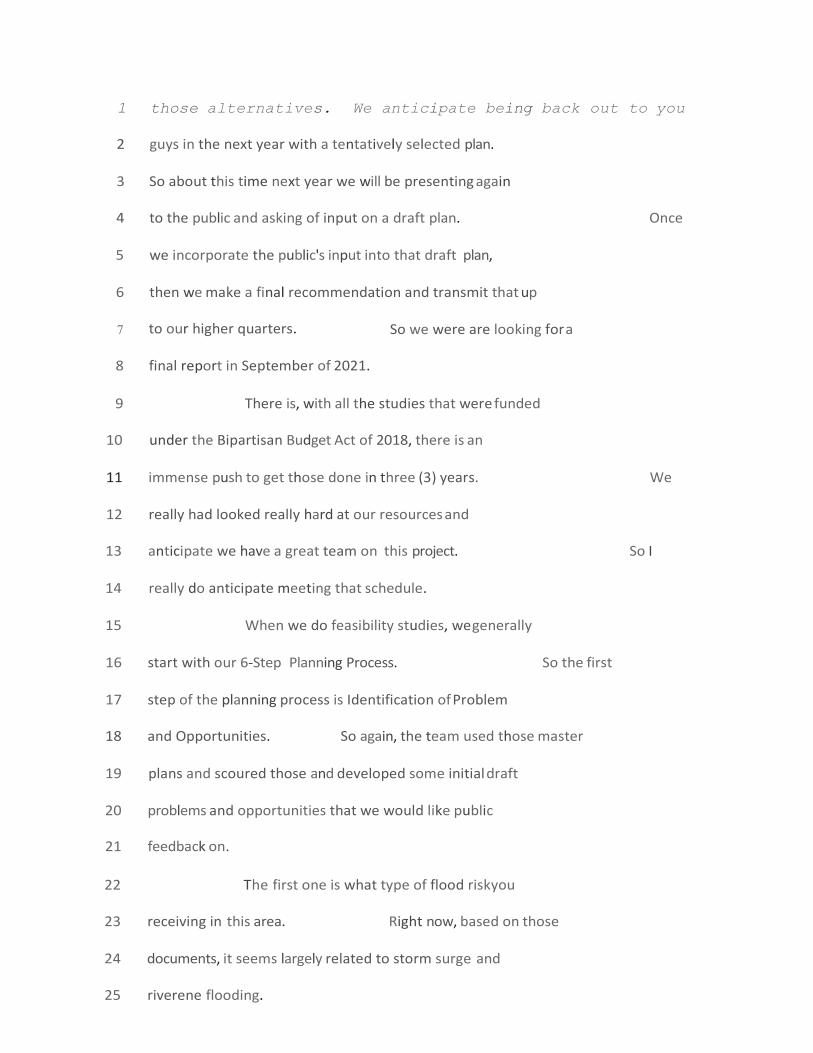
1 those alternatives. We anticipate being back out to you
2 guys in the next year with a tentatively selected plan.
3 So about this time next year we will be presenting again
4 to the public and asking of input on a draft plan. Once
5 we incorporate the public's input into that draft plan,
6 then we make a final recommendation and transmit that up
7 to our higher quarters. So we were are looking for a
8 final report in September of 2021.
9 There is, with all the studies that were funded
10 under the Bipartisan Budget Act of 2018, there is an
11 immense push to get those done in three (3) years. We
12 really had looked really hard at our resources and
13 anticipate we have a great team on this project. So I
14 really do anticipate meeting that schedule.
15 When we do feasibility studies, we generally
16 start with our 6-Step Planning Process. So the first
17 step of the planning process is Identification of Problem
18 and Opportunities. So again, the team used those master
19 plans and scoured those and developed some initial draft
20 problems and opportunities that we would like public
21 feedback on.
22 The first one is what type of flood risk you
23 receiving in this area. Right now, based on those
24 documents, it seems largely related to storm surge and
25 riverene flooding.

9
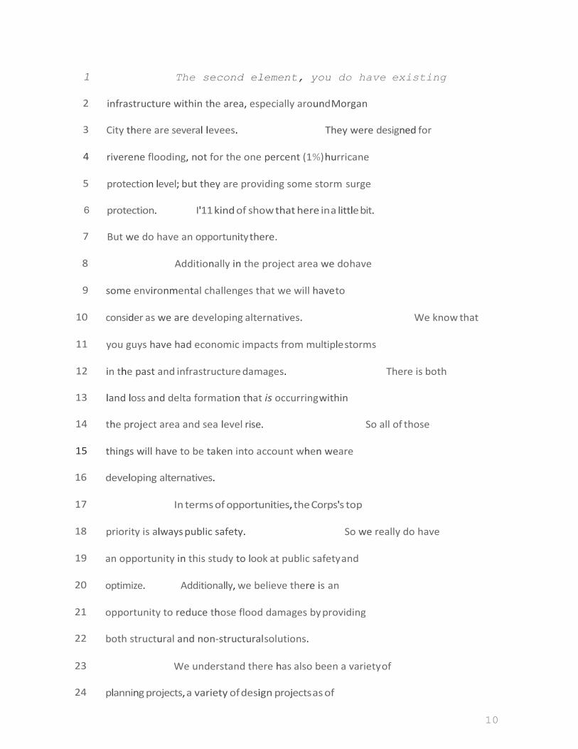
10
1 The second element, you do have existing
2 infrastructure within the area, especially around Morgan
3 City there are several levees. They were designed for
4 riverene flooding, not for the one percent (1%) hurricane
5 protection level; but they are providing some storm surge
6 protection. I'11 kind of show that here in a little bit.
7 But we do have an opportunity there.
8 Additionally in the project area we do have
9 some environmental challenges that we will have to
10 consider as we are developing alternatives . We know that
11 you guys have had economic impacts from multiple storms
12 in the past and infrastructure damages. There is both
13 land loss and delta formation that is occurring within
14 the project area and sea level rise. So all of those
15 things will have to be taken into account when we are
16 developing alternatives.
17 In terms of opportunities, the Corps's top
18 priority is always public safety. So we really do have
19 an opportunity in this study to look at public safety and
20 optimize. Additionally, we believe there is an
21 opportunity to reduce those flood damages by providing
22 both structural and non-structural solutions.
23 We understand there has also been a variety of
24 planning projects, a variety of design projects as of

11
25 late; and we think there is a real opportunity to

12
1 leverage local, state, and federal efforts and get us all
2 kind of pushing in the same direction.
3 Additionally, we also understand that Hwy 90 is
4 an evacuation route and that there is current issues with
5 flooding getting over that highway. So we will be
6 looking at maintaining that evacuation route as a non-
7 structural alternative as well.
8 So the second stop in the 6-step planning
9 process is to look at inventory and forecasts. So
10 essentially, you look at your project area and say, "What
11 is the current condition of both those human resources
12 and the natural resources for the new project area? u It
13 is a really important step. You also can forecast those
14 conditions out fifty (50) years into the future. That
15 step is really important because it essentially serves as
16 your baseline condition and you compare all of your
17 alternatives to that baseline condition. So it is really
18 important that we get that as accurate as possible.
19 And here, in terms of inventory, our team has
20 developed, or pulling information and data, from existing
21 models. This one, you can see is storm surge. And it
22 has been clipped to the project area. The model actually
23 goes out further than this. We can see here the 11.5 is
24 actually the design height of some of these Morgan City
25 levees . And you can see the storm surge is kind of
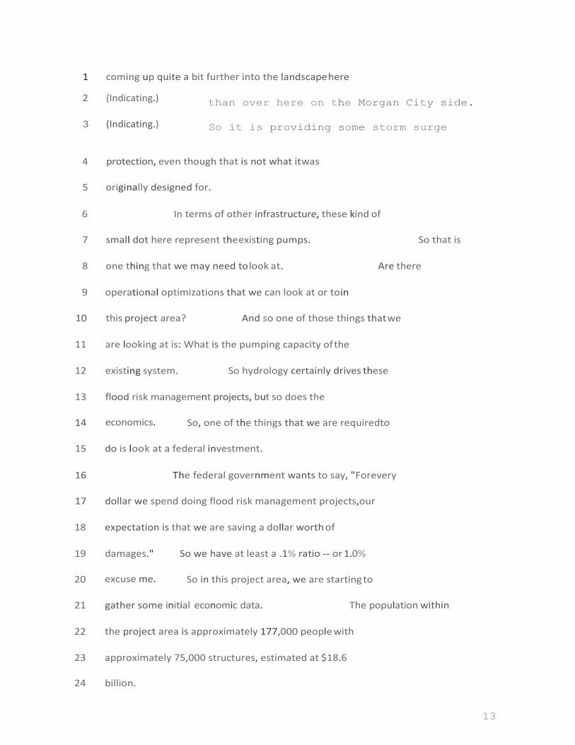
13
1 coming up quite a bit further into the landscape here
2 (Indicating.)
3 (Indicating.)
than over here on the Morgan City side.
So it is providing some storm surge
4 protection, even though that is not what it was
5 originally designed for.
6 In terms of other infrastructure, these kind of
7 small dot here represent the existing pumps. So that is
8 one thing that we may need to look at. Are there
9 operational optimizations that we can look at or to in
10 this project area? And so one of those things that we
11 are looking at is: What is the pumping capacity of the
12 existing system. So hydrology certainly drives these
13 flood risk management projects, but so does the
14 economics. So, one of the things that we are required to
15 do is look at a federal investment.
16 The federal government wants to say, "For every
17 dollar we spend doing flood risk management projects, our
18 expectation is that we are saving a dollar worth of
19 damages." So we have at least a .1% ratio -- or 1.0%
20 excuse me. So in this project area, we are starting to
21 gather some initial economic data. The population within
22 the project area is approximately 177,000 people with
23 approximately 75,000 structures, estimated at $18.6
24 billion.

14
25 And then we have that broke n down per parish
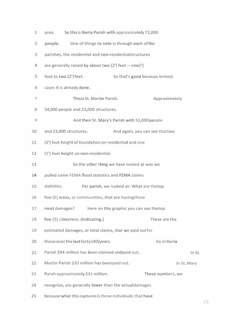
15
1 area. So this is Iberia Parish with approxima tely 72,000
2 people. One of things to note is through each of the
3 parishes, the residential and non-residential structures
4 are generally raised by about two (2') feet -- one (l')
5 foot to two (2') feet. So that's good because in most
6 cases it is already done.
7 This is St. Mart in Paris h. Approximately
8 54,000 people and 22,000 structures.
9 And then St. Mary's Parish with 51,000 people
10 and 23,000 structures. And again, you can see that two
11 (2') foot height of foundation on residentia l and one
12 (1') foot height on non-residential.
13 So the other thing we have looked at was we
14 pulled some FEMA flood statistics and FEMA claims
15 statistics. Per parish, we looked at: What are the top
16 five (5) areas, or communities, that are having those
17 most damages? Here on this graphic you can see the top
18 five (5) cities here. (Indicating.) These are the
19 estimated damages, or total claims, that we paid out for
20 those over the last forty (40) years. So in Iberia
21 Parish $94 million has been claimed and paid out. In St.
22 Martin Parish $20 million has been paid out. In St. Mary
23 Paris h approximately $31 million. These numbers, we
24 recognize, are generally lower than the actual damages
25 because what this captures is those individ ua ls that have

16
1 flood insurance . We know that there is a large
2 percentage of people in the project area that do not have
3 flood insurance, and data they wouldn't be captured here.
4 So that is one of the things that we going to be looking
5 for in the future to get better data on.
6 Other types of forecasts: So again, we look
7 at the natural environment as well and what is the
8 condition of those resources. Some of the information
9 that we have been pulling together is the land use within
10 in the project area is approximately seventy (70%) either
11 open water or wetland, with the next highest percentage
12 being cultivated crops. As you guys know, within those
13 cultivated crops, the larger percentage is sugar cane
14 within the project area.
15 So getting back to our alternatives, we are
16 required to have a no-action alternative. Essentially
17 what that mean is: What happens in the project area if we
18 do nothing? And we look at that from both the human
19 environment and the natural environmen t. Aga in, this is
20 the part where we look at fifty (50) years into the
21 future; and in that future forecast, here we have a few
22 of the elements that we will consider. (Indicating.) We
23 understand that there is increased flood risk in this
24 area due to increased storm surges which increase storm
17
25 damages as a result of increased frequency and intensity

18
1 of those storms. Again, we gather tidal, subsidence, and
2 land gains in the area. So we will be projecting all of
3 those different elements and using that baseline to
4 compare to our alternatives.
5 Eve ry project has constraints, and we have
6 those, of course, in our project. We will be required to
7 comply with all environmental laws; if there is any
8 mitigation costs, we will need to include that into our
9 alternatives cost and compare those.
10 Again, back to the appropriation authority, we
11 will not be able to formulate for eco-system restoration.
12 We will formulate only for flood risk damage.
13 Another key constraint that I want to mention
14 is: We will have to minimize any transfer of flood risks.
15 So getting back to that graphic where you saw the project
16 area outlined in pink, although that is the project area
17 and that will confine where we can take action, when we
18 do our analysis, our analysis will actually go out
19 farther than that. It will actually have to consider the
20 watersheds that are feeding into this area. And that is
21 really aimed at insuring that we are not transferring
22 flood risks .
23 Other things that we will need to consider is
24 any local infrastructure or transportation corridors. If

19
25 you have any projects that are going to be designed, or
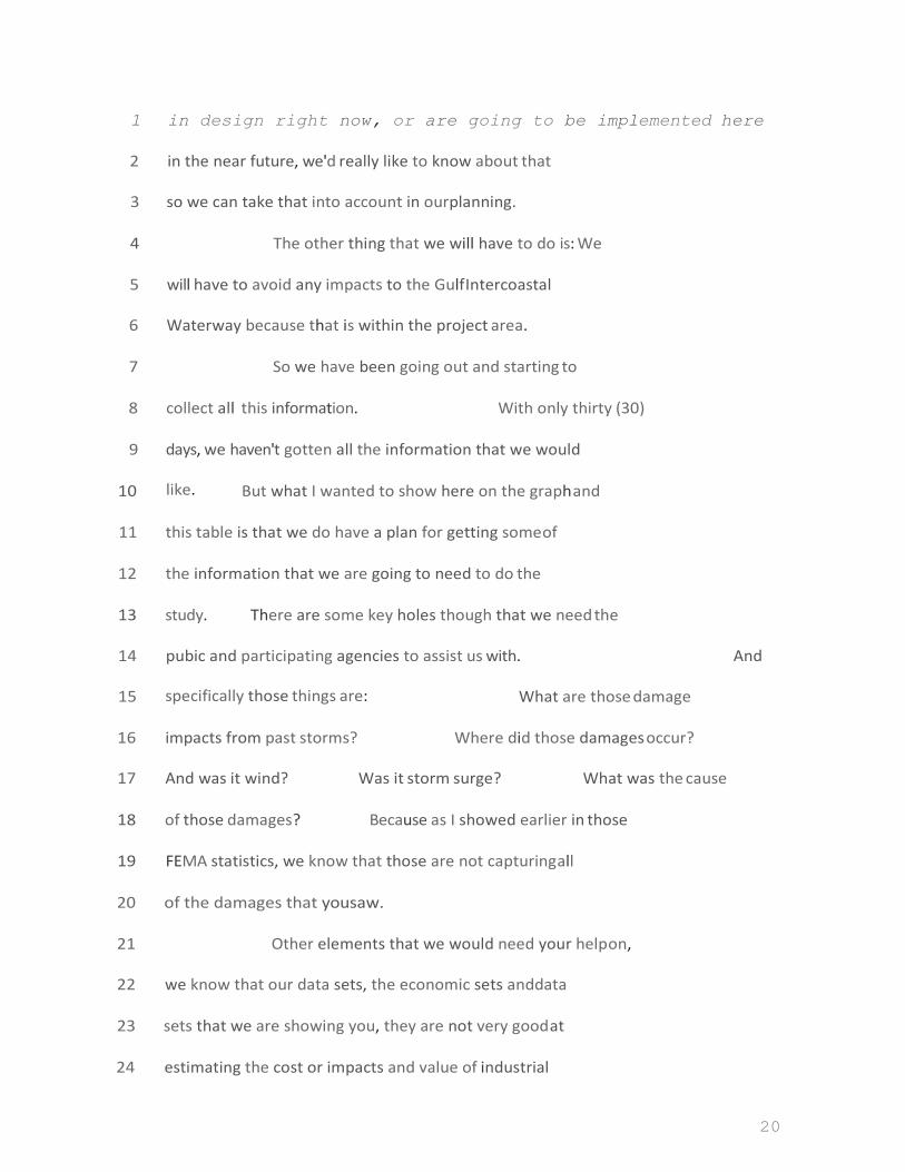
20
1 in design right now, or are going to be implemented here
2 in the near future, we'd really like to know about that
3 so we can take that into account in our planning.
4 The other thing that we will have to do is: We
5 will have to avoid any impacts to the Gulf Intercoastal
6 Waterway because that is within the project area.
7 So we have been going out and starting to
8 collect all this information. With only thirty (30)
9 days, we haven' t gotten all the information that we would
10 like. But what I wanted to show here on the graph and
11 this table is that we do have a plan for getting some of
12 the information that we are going to need to do the
13 study. There are some key holes though that we need the
14 pubic and participating agencies to assist us with. And
15 specifically those things are: What are those damage
16 impacts from past storms? Where did those damages occur?
17 And was it wind? Was it storm surge? What was the cause
18 of those damages? Because as I showed earlier in those
19 FEMA statistics, we know that those are not capturing all
20 of the damages that you saw.
21 Other elements that we would need your help on,
22 we know that our data sets, the economic sets and data
23 sets that we are showing you, they are not very good at
24 estimating the cost or impacts and value of industrial

21
25 areas which we know that you have in the project area.

22
1 And so we would be looking to get more information on
2 those industrial areas as well.
3 So that brings up to Step 3. So in Step 3 we
4 start formulating alternatives . Essentially , that is
5 just how we package the various ways that we can address
6 the problems and opportunities within the project area.
7 So of course, again, we will look at a no-action
8 strategy. We will also look at a structural alternative.
9 Our project sponsor , CPRA, funded a study through Arcadis
10 that we intend to use in this project and we will look at
11 it. That study was largely structural, so we will
12 certainly look at that as an alternative . Additionally,
13 we will look at non-structural alternatives, and any
14 combination thereof.
15 So that is how we would address the problems
16 and opportunities I the project area. But we would also
17 look at where we would address those problems and
18 opportunities. So we will look at, you know, those
19 damages as we understand tend to be clustered. And so we
20 will start to look at how those areas were clustered and
21 formulate alternatives on those vario us locations.
22 So many of you are familiar with non-structural
23 alternatives. Generally I think what comes to most
24 people's mind is voluntary buy-outs, structural raises.

23
25 But there is also other things that we can consider like

24
1 evacuation planning, what wet-proofing and dry-proofing
2 and those types of things. And so we will consider all
3 of those things for this project on the table.
4 So once we have our alternatives kind of
5 packaged, then we have to evaluate and compare them to
6 one another to really see where we are getting the best
7 bang for our buck. And so we are interested in hearing
8 from you if there is anything that you would like us to
9 evaluate, any kind of valuation criteria . But the
10 criteria that I have here on the slides are just some of
11 those kind of general criteria that we are required to
12 look at the Corps Of Engineers. So we always look at
13 average annual damages reduction, reduction of risk to
14 life loss, reduction in the primary costs. Those costs
15 would include any mitigation costs as well as full
16 operation and maintenance costs over the project life
17 cycle. So that would be over the fifty (50) years and
18 that would all be included in those packages.
19 So again, what we need from you: We need to
20 better understand are we capturing those problems and
21 opportunities that are within the project area? Are
22 there additional problems that we need to add? What
23 flood event did your community see the most damages? O
24 And was that flood event storm surge? Was it riverene

25
25 flooding? Was it back-water flooding? What type of
26
1 flooding was that? Are there alternative strategies that
2 would better address the problems that we have in the
3 project area? Are there additional constraints in our
4 future develo pment or things that we should consider as
5 we are developing alternatives? And finally, is there
6 any data or studies that the project team should know
7 about and information that we can use so that we don't
8 have to re-create the way and hopefully move a little/
9 faster in this project? We'd really appreciate that.
10 So with that -- Just keep going?
11 AUDIENCE MEMBER:
12 CARLA SPARKS:
Yeah.
13 So we don't have a formal comment like "ending
14 period", which is probably not as familiar for
15 folks.
16 We are currently accepting public comments. At
17 some point in the future, we will put out a formal nebo-
18 scoping request and then give a final date for comments
19 in this initial phase. And we will make sure you guys
20 are all notified of that.
21 But if you do have public comments, we can
22 either take them tonight, we do have cards that you can
23 send in later, and/or you can write down the Project
24 Manager , Carrier (Schott), here. And you can send your

27
25 public comments to her.
28
1
2 And on the back table, if you want to grab a
3 card, it has how to submit comments. But you know,
4 again, we are welcome to take your comments tonight.
5 Anyone, by all means? Or if you have any questions on
6 what we weren't clear on or anything, by all means that
7 is why we are here.
8 JOHN LOMBARDO: Again, we have tons of
9 data. We have tons of information on anything in this
10 District which are welcome to. The gaps that we have, we
11 have information on them , we have plans, we' ve got
12 alternatives. You know, we' ve got tons of information
13 (...unintelligib le.) You are more than welcome to it. I
14 mean you can just go to out website and get it. There is
15 an inter-active map on the website that has elevation
16 points through our current levee system.
17 The majority of our system is a riverene
18 system. Now some of the areas we have raised to get them
19 within that one (1%) percent storm surge elevation.
20 Other areas -- It is just a lot. We haven't gotten there
21 yet. We are trying to get our system closed first, and
22 then we will starting getting them to those points
23 throughout.
24 But we do have -- I know Tim was with y'all

29
25 this afternoon. We do have the area of Lakeside and the
30
1 levees west of the Charenton Canal where there is
2 nothing.
3 I spent a couple of months a while back
4 s ur veying (...unintelligible.) trying to get a feel for
5 the area, looking at what's down there -- farmland,
6 structures, houses -- just getting a feel for it. So we
7 have a lot of information we are wiling to share with
8 insight. You know, the locals know what they want and
9 what they need.
10 CARLA SPARKS: That's right.
11 JOHN LOMBARDO: It is a pleasing game. So give me a
12 heads up if y'all want to come down for a day and we can
13 share information all day long and pass on surveys and
14 all kinds of stuff.
15 CARLA SPARKS: That would be great. Yes, that
16 would be very helpful.
17 JOHN LOMBARDO: So we are here to help any way we
18 can.
19 OFFICER: Do we have anyone else that wants to
20 comment? I don' t know, I don' t want to keep y'all longer
21 than we need. But, you know, again, we are only in the
22 beginning. We' ve got a lot to go, or I guess to say the
23 formal comment period time hasn' t even begun. So out of
24 the thirty (30) day period we have, we will make that
25 announcement to the public and to the press and ask that

31
1 you are aware of it. If anybody has any kind of words?
2 MONICA MANCUSO: (...unintelligible.) point of
3 (...unintelligible.)
4 COURT REPORTER:
5 Can you bring her the mic, please, because I cannot
6 hear behind me.
7 OFFICER: Sure. I am going to ask you to talk
8 loudly.
9 MONICA MANCUSO: From what I understand, LSU has
10 listed Morgan City as (...unintelligible.)
11 CARLA SPARKS: Great. But did you say you were
12 involved in some sort of economic studies?
13 MONICA MANCUSO: The Urban Land Institute.
14 CARLA SPARKS: Okay. I' ve heard of it.
15 MONICA MANCUSO:
16 (...unintelligible.)
T(...unintelligible.) September
17 CARLA SPARKS: Is there some document that came out
18 of that?
19 MONICA MANCUSO: Yes, (...unintelligible.)
20 CARLA SPARKS: Okay. Great.
21 MICHAEL BROCATO: The Urban Land Institute.
22 MONICA MANCUSO and ANOTHER LADY: (...unintelligible.
23 Talking over each other.)... the coastal resiliency at
24 Simmesport ... Future land use and develo pme nt plan that

32
25 was done for the City. It is on the City's website under

33
1 "Planning and Zoningu. T he structures there are current
2 as of 2012. I know that sounds like a long time ago, but
3 we haven't had a lot of growth here.
4 MICHAEL BROCATO: Actually a lot of this is in the
5 works (...unintelligible.) two (2) years or three (3)
6 years ago it started.
7 (...unintelligible.)
8 LADY IN AUDIENCE:
So there are a lot
Yeah, Mr. Matte talked about
9 three (3) different projects.
10 MICHAEL BROCATO: Yeah. Did he mention Bayou 11 Chene, Bayou Teche, Yokley Levee Extension, Yokley Levee
12 Improvement -- I mean the list goes on or and on.
13 And again, if you look at our website SMLD.org,
14 there is tons of information on it. There inter-active
15 map will probably give you 90% of what you want.
16 Also, I'll brag on Dr. Mancuso. She is a
17 former educator and is retired and is now doing what she
18 can volunteering on the economic development of the area.
19 So we really appreciate her.
20 OFFICER: Thank you, sir.
21 Anyone? I' m going once?
(No response.) Going
22 twice? (No response.)
23 Thank you very much for coming out and we will
24 see you guys all again in what -- a year -- a year and a

34
25 half and we will have our ideas and our approach to

24
25
24
1 present to you guys and get the feedback on it.
2 But thank you all. If you have any questions,
3 do not hesitate to call any one of the Corps people in
4 this room and we will be happy to help you all we can.
5 Thank you very much for coming.
6 * * * * * * 7
8
9
10
11
12
13
15
16
17
18
19
20
21
22
23

24
25
25
1 STATE OF LOUISIANA (Rev. 1/1/2013)
2 PARISH OF ST MARY
3 REPORTER'S CERTIFICATE
4 I, ELIZABETH RHODES McCL EARY, Officia l Co urt
5 Reporter for the 16th Judicial District Court, Parishes of St. Mary , Iberia , and St. Martin , of the State of
6 Louisiana, employed as a court reporter for the 16th
7 Jud icial District Court, State of Louisiana, as the
8 officer before whom this testimony was taken, do hereby certify that this testimony was reported by me was
9 prepared and transcribed by me or under my direction and
10 supervision, and is a true and correct transcript to the
11 best of my ability and understanding, that the transcript has been prepared in compliance with the transcript
12 format guidelines required by statute or by the rules of
13 the board or by the Supreme Court of Louisiana and the
14 Federal Rules, and that I am not related to counsel or to the parties herein, nor am I otherwise interested in the
15 outcome of this matter.
16 This certificate is valid only for a transcript
17 accompa nied by my original signature and official required seal on this page.
18 IN WITNESS WHEREOF, I have affixed my official
19 signature this 28th day of August, 2018 at Patterson, St.
20 Mary Parish, Louisiana.
21
22 Official Court Reporter 23 16th Judicial District Court