South Capitol Street Trail Draft Concept Plan Chapter 4 pages 42-48
7
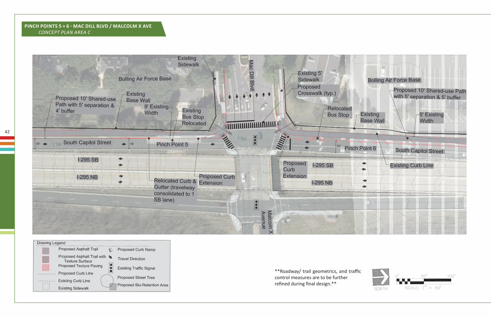
42 pinch poinTs 5 + 6 - mac dill Blvd / malcolm X ave concept plAn AreA c **Roadway/ trail geometrics, and traffic control measures are to be further refined during final design.**
-
Upload
anacostiawaterfront -
Category
Documents
-
view
19 -
download
0
description
South Capitol Street Trail Draft Concept Plan Chapter 4 pages 42-48
Transcript of South Capitol Street Trail Draft Concept Plan Chapter 4 pages 42-48
42
pinch poinTs 5 + 6 - mac dill Blvd / malcolm X ave concept plAn AreA c
**Roadway/ trail geometrics, and traffic control measures are to be furtherrefined during final design.**
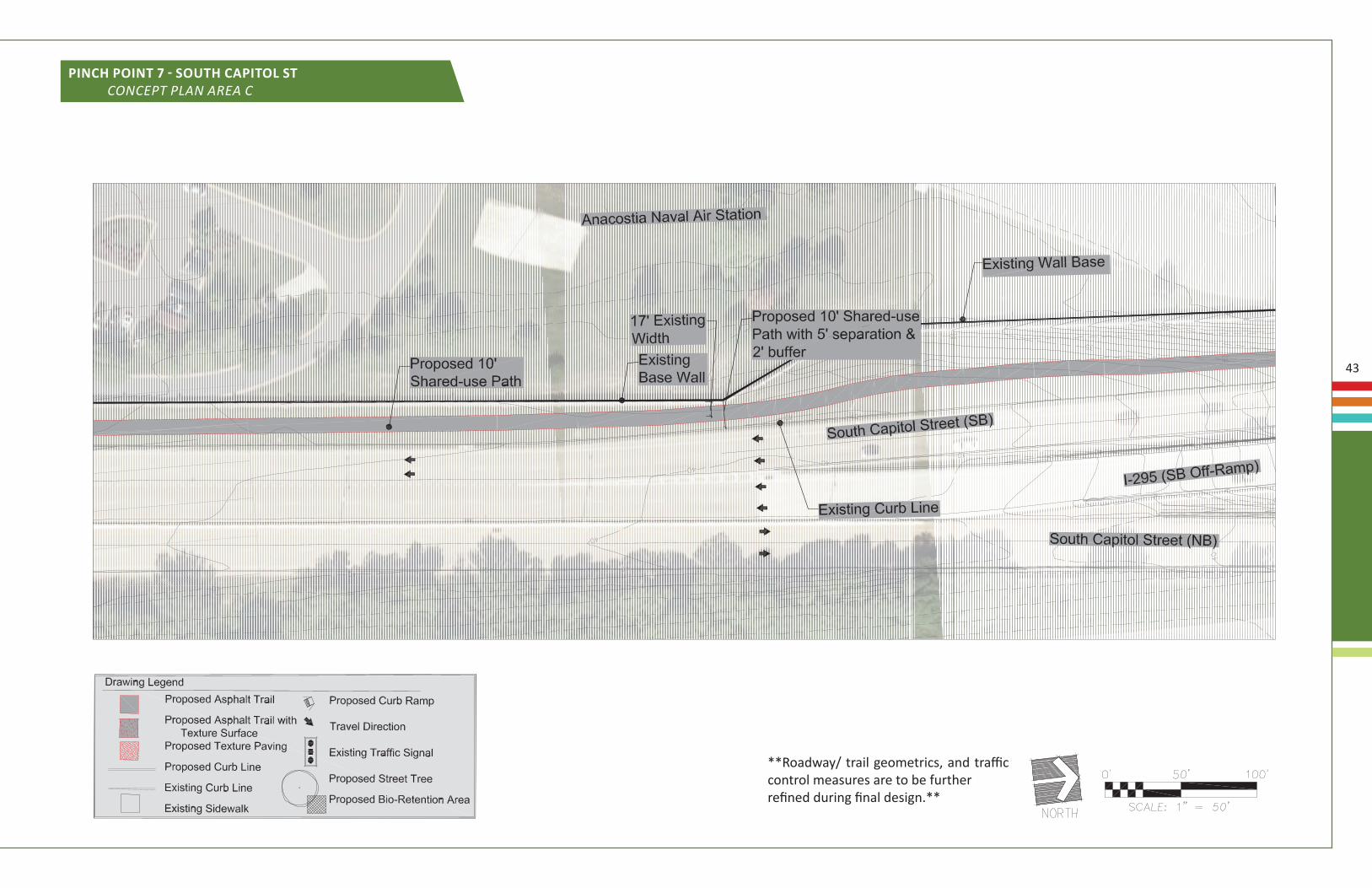
43
pinch poinT 7 - soUTh capiTol sT concept plAn AreA c
**Roadway/ trail geometrics, and traffic control measures are to be furtherrefined during final design.**
44
(this page was left blank intentionally)
45
c o n c e p T p l a n a r e a d
Potential connections along South Capitol Street and the proposed trail within the campus should be improved, and approached as an alternate connection for trail users using the South Capitol Street Trail. The proposed trail segment along the DHS roadway would serve as an additional connection to the South Capitol Street Trail for the hundreds of federal employees working on the campus and potentially utilizing the trail for recreational and transportation purposes. As a result, pending the final preferred alternative for the access roadways, and interchange configuration upgrades, the preferred alternative should include a suitable connection for trail users to access the South Capitol Street Trail from the eastside of I-295 at the St. Elizabeth’s Campus, and the neighborhoods along the I-295 corridor.
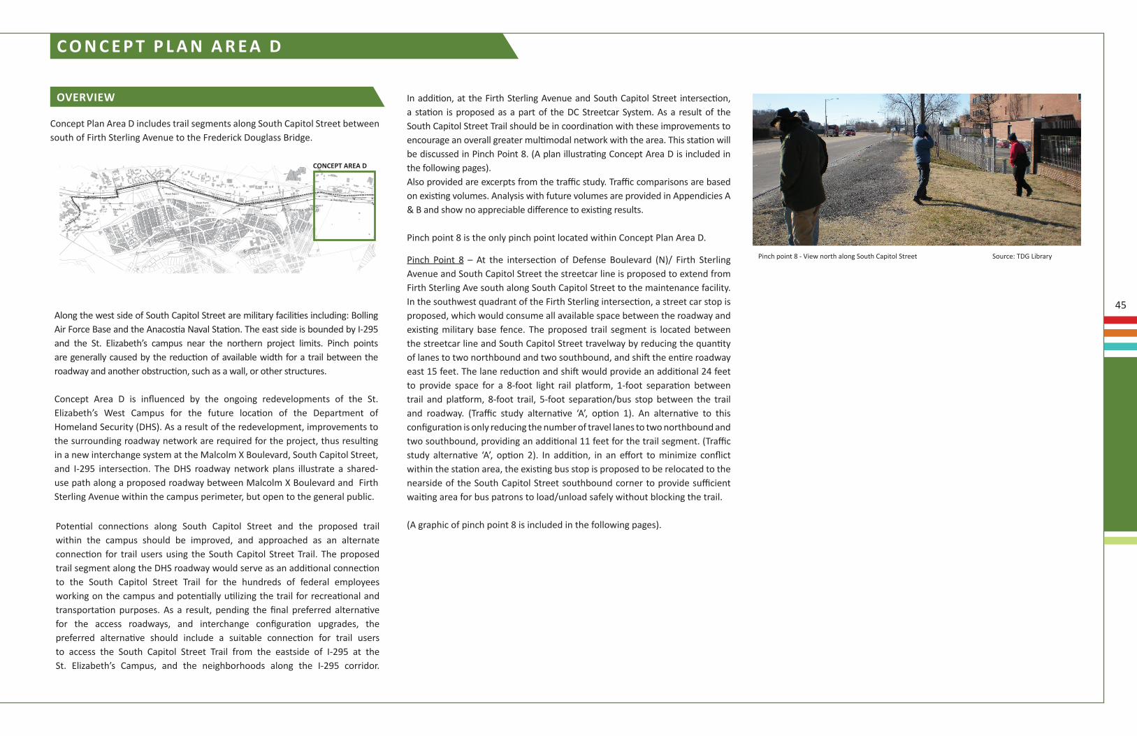
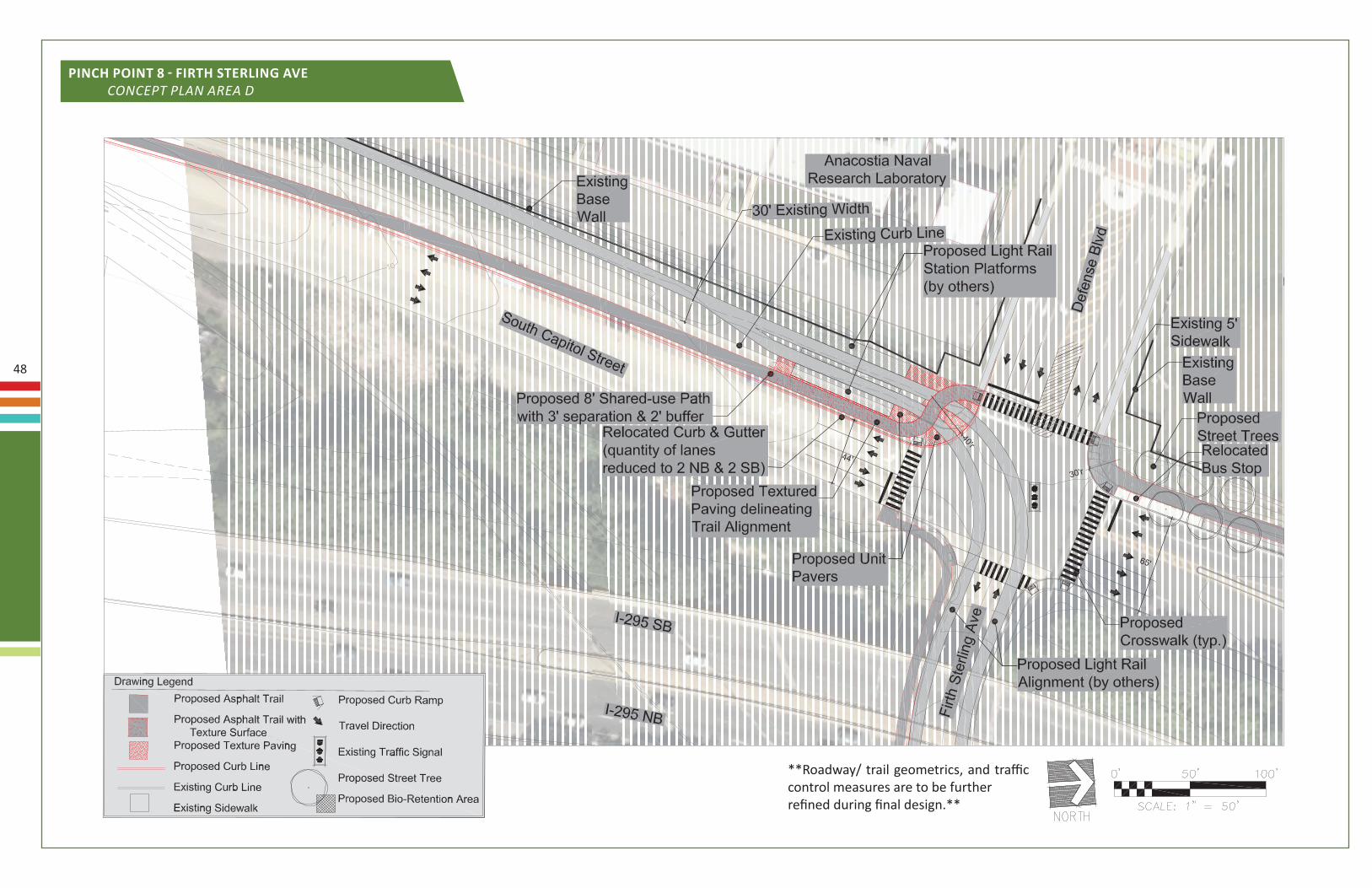
Pinch Point 8 – At the intersection of Defense Boulevard (N)/ Firth Sterling Avenue and South Capitol Street the streetcar line is proposed to extend from Firth Sterling Ave south along South Capitol Street to the maintenance facility. In the southwest quadrant of the Firth Sterling intersection, a street car stop is proposed, which would consume all available space between the roadway and existing military base fence. The proposed trail segment is located between the streetcar line and South Capitol Street travelway by reducing the quantity of lanes to two northbound and two southbound, and shift the entire roadway east 15 feet. The lane reduction and shift would provide an additional 24 feet to provide space for a 8-foot light rail platform, 1-foot separation between trail and platform, 8-foot trail, 5-foot separation/bus stop between the trail and roadway. (Traffic study alternative ‘A’, option 1). An alternative to this configuration is only reducing the number of travel lanes to two northbound and two southbound, providing an additional 11 feet for the trail segment. (Traffic study alternative ‘A’, option 2). In addition, in an effort to minimize conflict within the station area, the existing bus stop is proposed to be relocated to the nearside of the South Capitol Street southbound corner to provide sufficient waiting area for bus patrons to load/unload safely without blocking the trail.
(A graphic of pinch point 8 is included in the following pages).
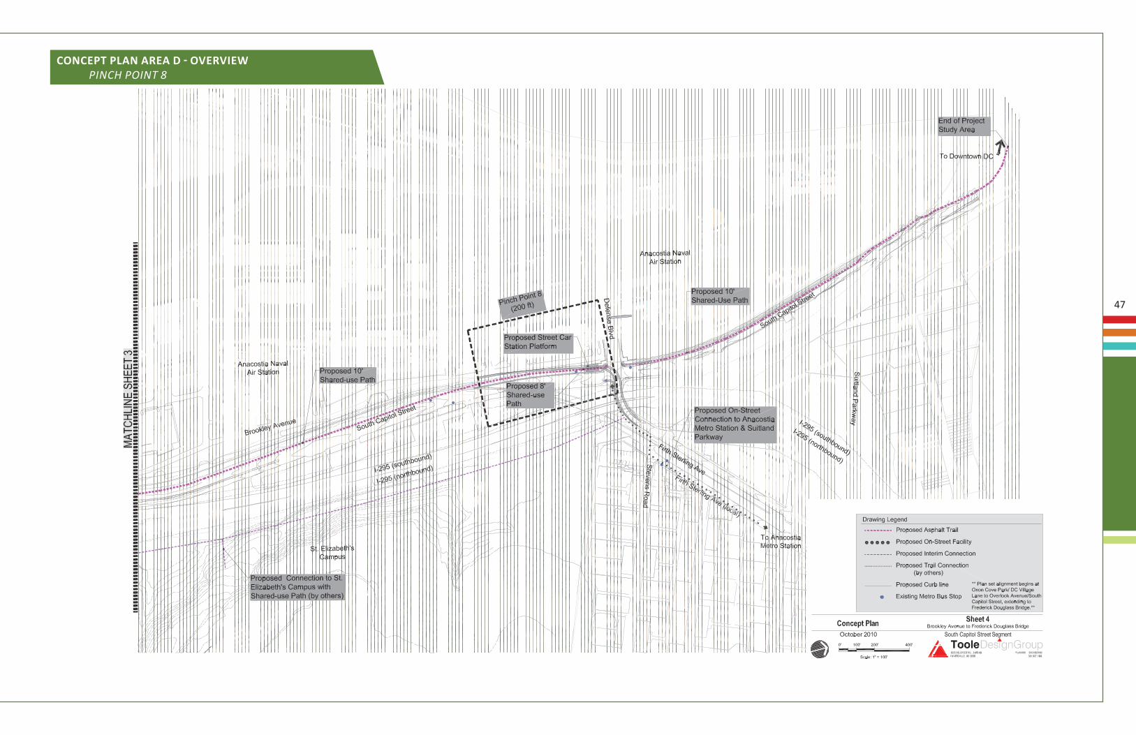
concepT area d
Concept Plan Area D includes trail segments along South Capitol Street between south of Firth Sterling Avenue to the Frederick Douglass Bridge.
overview
Along the west side of South Capitol Street are military facilities including: Bolling Air Force Base and the Anacostia Naval Station. The east side is bounded by I-295 and the St. Elizabeth’s campus near the northern project limits. Pinch points are generally caused by the reduction of available width for a trail between the roadway and another obstruction, such as a wall, or other structures.
Concept Area D is influenced by the ongoing redevelopments of the St. Elizabeth’s West Campus for the future location of the Department of Homeland Security (DHS). As a result of the redevelopment, improvements to the surrounding roadway network are required for the project, thus resulting in a new interchange system at the Malcolm X Boulevard, South Capitol Street, and I-295 intersection. The DHS roadway network plans illustrate a shared-use path along a proposed roadway between Malcolm X Boulevard and Firth Sterling Avenue within the campus perimeter, but open to the general public.
In addition, at the Firth Sterling Avenue and South Capitol Street intersection, a station is proposed as a part of the DC Streetcar System. As a result of the South Capitol Street Trail should be in coordination with these improvements to encourage an overall greater multimodal network with the area. This station will be discussed in Pinch Point 8. (A plan illustrating Concept Area D is included in the following pages).Also provided are excerpts from the traffic study. Traffic comparisons are based on existing volumes. Analysis with future volumes are provided in Appendicies A & B and show no appreciable difference to existing results.
Pinch point 8 is the only pinch point located within Concept Plan Area D.
Pinch point 8 - View north along South Capitol Street Source: TDG Library
46
6RXWK�&DSLWRO�6WUHHW�2YHUORRN�$YHQXH�7UDLO�²�7UDQVSRUWDWLRQ�6WXG\� S���
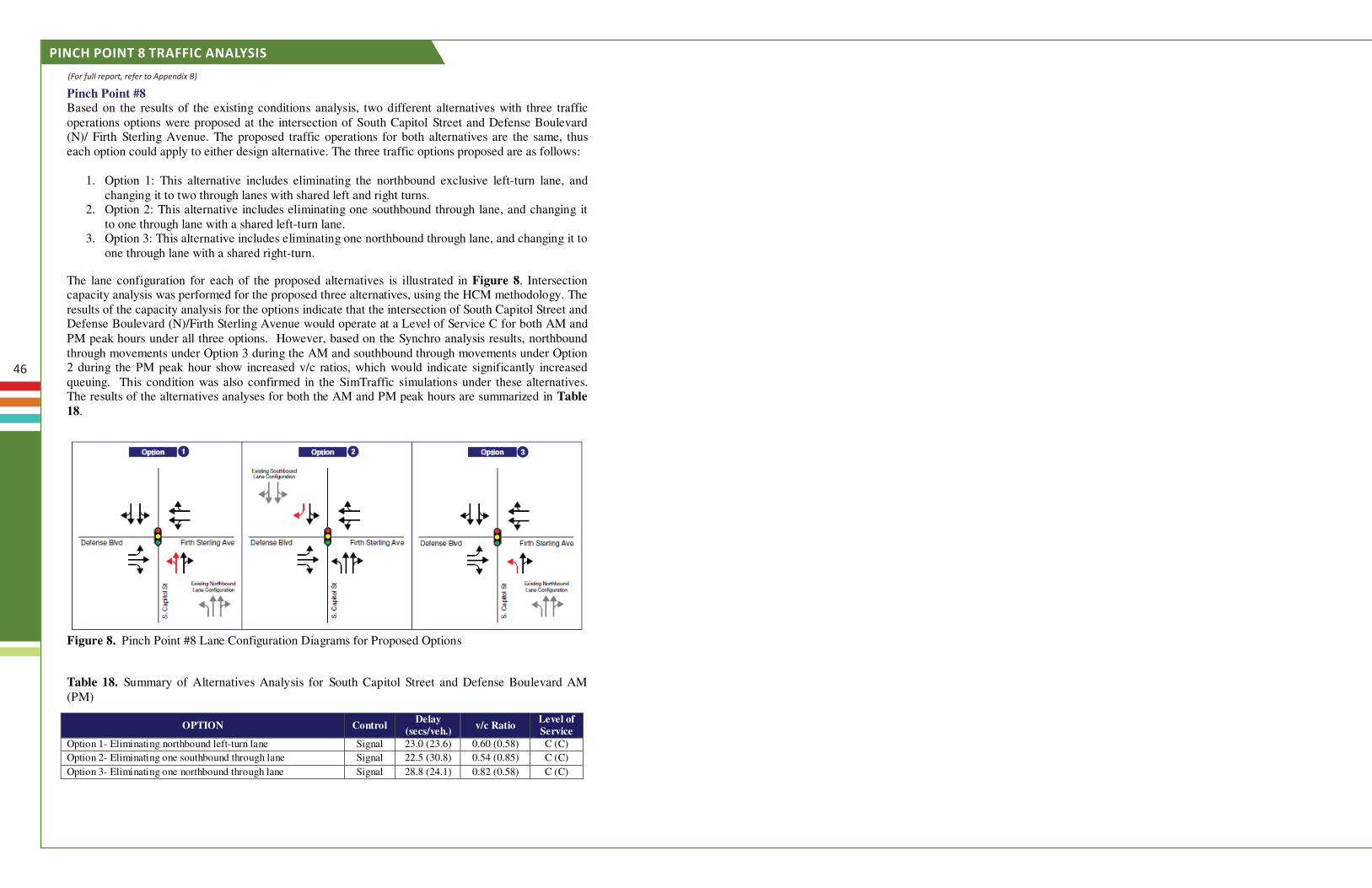
Pinch Point #8 Based on the results of the existing conditions analysis, two different alternatives with three traffic operations options were proposed at the intersection of South Capitol Street and Defense Boulevard (N)/ Firth Sterling Avenue. The proposed traffic operations for both alternatives are the same, thus each option could apply to either design alternative. The three traffic options proposed are as follows:
1. Option 1: This alternative includes eliminating the northbound exclusive left-turn lane, and changing it to two through lanes with shared left and right turns.
2. Option 2: This alternative includes eliminating one southbound through lane, and changing it to one through lane with a shared left-turn lane.
3. Option 3: This alternative includes eliminating one northbound through lane, and changing it to one through lane with a shared right-turn.
The lane configuration for each of the proposed alternatives is illustrated in Figure 8. Intersection capacity analysis was performed for the proposed three alternatives, using the HCM methodology. The results of the capacity analysis for the options indicate that the intersection of South Capitol Street and Defense Boulevard (N)/Firth Sterling Avenue would operate at a Level of Service C for both AM and PM peak hours under all three options. However, based on the Synchro analysis results, northbound through movements under Option 3 during the AM and southbound through movements under Option 2 during the PM peak hour show increased v/c ratios, which would indicate significantly increased queuing. This condition was also confirmed in the SimTraffic simulations under these alternatives. The results of the alternatives analyses for both the AM and PM peak hours are summarized in Table 18.
Figure 8. Pinch Point #8 Lane Configuration Diagrams for Proposed Options
Table 18. Summary of Alternatives Analysis for South Capitol Street and Defense Boulevard AM (PM)
OPTION Control Delay
(secs/veh.) v/c Ratio
Level of Service
Option 1- Eliminating northbound left-turn lane Signal 23.0 (23.6) 0.60 (0.58) C (C)
Option 2- Eliminating one southbound through lane Signal 22.5 (30.8) 0.54 (0.85) C (C)
Option 3- Eliminating one northbound through lane Signal 28.8 (24.1) 0.82 (0.58) C (C)
pinch poinT 8 Traffic analysis
(For full report, refer to Appendix B)
47
concepT plan area d - overview pinch point 8
48
pinch poinT 8 - firTh sTerlinG ave concept plAn AreA D
**Roadway/ trail geometrics, and traffic control measures are to be furtherrefined during final design.**