SOURCEWATER PROTECTION PLAN - Connecticut
51
SOURCEWATER PROTECTION PLAN for the Little River Watershed A Public Drinking Water Supply Source for Putnam, Connecticut February 2006 Prepared by: Little River Sourcewater Protection Team Primary Contacts Bill Trayner, Director Putnam WPCA 126 Church Street Putnam, Connecticut 06260 860.963.6819 John Guszkowski, Planner Town of Woodstock 415 Route 169 Woodstock, Connecticut 06281 860.963.2128 Scott Gravatt, Director E. CT Conservation District 139 Wolf Den Road Brooklyn, Connecticut 06234 860.774.8397 X203 Marc Cohen Atlantic States Rural Water & Wastewater Association PMB #275, 12 New London Turnpike Norwich, Connecticut 060360 860.889.6373 Review and Update Annually Date Reviewed Reviewer Changes or Comments
Transcript of SOURCEWATER PROTECTION PLAN - Connecticut

SOURCEWATER PROTECTION PLAN
for the
Little River Watershed
A Public Drinking Water Supply Source for Putnam, Connecticut
February 2006
Prepared by:
Little River Sourcewater Protection Team
Primary Contacts
Bill Trayner, Director
Putnam WPCA 126 Church Street
Putnam, Connecticut 06260 860.963.6819
John Guszkowski, Planner
Town of Woodstock 415 Route 169
Woodstock, Connecticut 06281 860.963.2128
Scott Gravatt, Director E. CT Conservation District
139 Wolf Den Road Brooklyn, Connecticut 06234
860.774.8397 X203
Marc Cohen Atlantic States Rural Water &
Wastewater Association PMB #275, 12 New London Turnpike
Norwich, Connecticut 060360 860.889.6373
Review and Update Annually Date Reviewed Reviewer Changes or Comments


Table of Contents 1 Introduction..................................................................................................... 5 2 Local Sourcewater Protection Team .............................................................. 5 3 Little River Watershed .................................................................................... 7
3.1 Natural Setting ........................................................................................ 7 3.2 Characteristics and Water Quality .......................................................... 7 3.3 Sourcewater Protection Area .................................................................. 9 3.4 Summary of the Putnam Water District .................................................. 9 3.5 Town of Woodstock ................................................................................ 9 3.6 Other Towns ......................................................................................... 10 3.7 Sourcewater Inventory .......................................................................... 10
4 Existing/Current Sourcewater Protection Measures ..................................... 10 4.1 Putnam WPCA ..................................................................................... 10 4.2 Wyndham Land Trust ........................................................................... 10 4.3 Eastern CT Resource Conservation & Development Council ............... 10 4.4 Eastern CT Conservation District ......................................................... 11 4.5 Town of Woodstock .............................................................................. 11
5 Summary of CT DPH Sourcewater Assessment (Exhibit IV) ........................ 11 6 Potential Contaminant Source Inventory ...................................................... 12
6.1 Summary of DPH Potential Contaminant Source Inventory .................. 12 6.2 Update of Potential Contaminant Source Inventory .............................. 12
7 Assessment of Threats ................................................................................. 13 7.1 Confirmed Contaminant Detects of Concern in Sourcewater ............... 13 7.2 Roadways ............................................................................................. 13 7.3 On-Site Septic Systems ........................................................................ 13 7.4 Land Use .............................................................................................. 13 7.5 Anthropogenic (Man Made) Potential Contaminant Sources ................ 15 7.6 Point Sources of Pollution ..................................................................... 15 7.7 Non-Point Sources of Pollution ............................................................. 15 7.8 Stormwater Management ..................................................................... 16 7.9 Potential Future Sources ...................................................................... 16
8 Management Plan ........................................................................................ 17 8.1 Comprehensive Evaluation of the Watershed ....................................... 17 8.2 Agricultural Best Practices .................................................................... 17 8.3 Purchase or otherwise Protect Watershed Land .................................. 18 8.4 Conduct Education and Outreach Campaign ....................................... 18 8.5 Include Drinking Water Protection in Town Planning and Ordinances .. 19 8.6 Support Efforts to De-list Roseland Lake .............................................. 19 8.7 Muddy Pond ......................................................................................... 19 8.8 Form Sourcewater Protection Steering Committee .............................. 20
9 Contingency Plan ......................................................................................... 20

List of Exhibits Exhibit I: Woodstock and Putnam Support Resolutions ................................... 21 Exhibit II: Little River Watershed Map .............................................................. 23 Exhibit III: Public Water Systems .................................................................... 24 Exhibit IV: DPH Sourcewater Assessment Report ........................................... 25 Exhibit V: Woodstock Land Use Map ............................................................... 29 Exhibit VI: FY 2006 319 Grant Application ....................................................... 30 Exhibit VII: Septic System Outreach Brochure ................................................. 42 Exhibit VIII: Connecticut Watershed Statutes, Regulations & Guidelines ........ 44

Little River Sourcewater Protection Plan Page 5 of 51
1 Introduction The ideal surface water drinking supply would have excellent natural water quality and no potential contaminant sources (PCSs). There would be no development in the watershed and no surface use. We are fortunate to have good natural water quality in most of Connecticut’s surface drinking water supplies, however PCSs exist for every surface water supply and development and recreational uses continue. Atlantic States Rural Water & Wastewater Association (ASRWWA) believes that threats from many PCSs can mitigated by proper construction, applying best management practices (BMPs) and the responsible use of the resource. Therefore education, outreach and the ability to develop and maintain working relationships in the community are important factors in sourcewater protection. The purpose of the Little River Watershed Protection Plan is to reduce or eliminate potential and existing risks to the Putnam Water Pollution Control Authority (WPCA) drinking water supply and public water system wells in Woodstock. The management plan included here outlines specific actions available to the community to protect the watershed while avoiding adverse impacts on the other activities in the watershed. The plan is prepared by the ASRWWA in cooperation with the National Rural Water Association. Program funding is provided by the United States Department of Agriculture’s (USDA) Sourcewater Protection Program. The purpose of the program is to provide technical assistance to rural and small communities for the development of Sourcewater Protection Plans (SWPPs). These Sourcewater Protection Plans build on the Sourcewater Assessment Program of the Connecticut Department of Public Health (DPH). This program determined the susceptibility of the public water systems in Connecticut to PCSs. The SWPP process is community based and uses the DPH assessment data to develop and implement a sourcewater protection plan. The main tasks are:
Form a Local Sourcewater Protection Team Verify and update PCS inventory done by the DPH Assess threats to the drinking water source Develop management strategies for these threats Form a Steering Committee to oversee implementation and update plan
periodically Develop a contingency plan in the event the supply is lost
2 Local Sourcewater Protection Team The Little River Sourcewater Protection Team is a diverse group. The goal is to represent a cross-section of stakeholders in the watershed, including Putnam WPCA and town officials, Woodstock town officials and board members,

Little River Sourcewater Protection Plan Page 6 of 51
business, agriculture, and organizations currently involved in resource conservation efforts. Below is a list of local stakeholder groups and who they are represented by on the team: Organization Represented by Atlantic States Rural Water & Wastewater Assoc Marc Cohen Audubon Society Andy Rzezinkiewicz Connecticut Dept. of Environmental Protection Eric Thomas E. CT Resource Conservation and Development John Guszkowski Eastern Connecticut Conservation District Scott Gravatt, Greg Smith Green Valley Institute Holly Drinkuth Local Builders Doug Porter Local Farmers Paul Miller Local Outdoor Recreation Business Ian MacRae Muddy Pond Neighborhood Mary Ellen Blake The Nature Conservancy Cyrus Harvey, Jr Northeast District Department of Health Maureen Marcoux Putnam Town Administration Doug Cutler Putnam Water Pollution Control Authority Bill Trayner Quinebaug-Shetucket Heritage Corridor Jean Cass Roseland Park Ed Higgins UConn Cooperative Extension Joyce Meader UDSA Natural Resources Conservation Service Nancy Ferlow Woodstock Conservation Commission Jean Pillo Woodstock Planning Department John Guszkowski Woodstock Planning & Zoning Commission Sandy Rotival Woodstock Town Administration Delpha Very Woodstock Water Pollution Control Authority Peter Ellsworth Wyndham Land Trust Dick Booth
Team members (clockwise) Mary Ellen Blake, Jean Pillo, Sandy Rotival, Paul Miller, Doug Cutler, Bill Trayner, Stewart Morse, Maureen Marcoux (hidden) and John Guszkowski review final draft of plan.

Little River Sourcewater Protection Plan Page 7 of 51
The Team would like to thank the Towns of Putnam and Woodstock for their support. Resolutions of support were passed in each town and are included as Exhibit I.
3 Little River Watershed
3.1 Natural Setting Little River is located in northeast Connecticut and is a tributary of the Quinebaug River that, in turn, is a tributary of the Thames River which empties into Long Island Sound. Exhibit II shows the Little River watershed (CT DEP Basin Nos. 3706, 3707 & 3708) location and topography. The watershed lies primarily in the town Woodstock with small portions in Pomfret, Putnam and Thompson, Connecticut and Southbridge, Massachusetts. The watershed is approximately 11 miles long (north to south) and approximately 5 miles wide (east to west) and covers 39.0 square miles. The diversion of water at the Peake Brook Road Water Treatment Plant is located at a dam approximately two and a half miles north of the confluence of Little River and Quinebaug River in Putnam. The area of the watershed located upstream of the diversion is 35.4 square miles. Upstream of the diversion Little River is impounded in two surface water bodies – Shepherds Pond (nearest the diversion) and Roseland Lake. The lower end of Shepherds Pond is approximately one mile north of the dam. It is relatively narrow, surrounded by wetlands and has a surface area of approximately 11 acres. The lower end of Roseland Lake is approximately 1.8 miles upstream of the diversion (north of Stone Bridge Road in Woodstock). The lake is owned jointly by the Town of Woodstock and the State of Connecticut. Roseland Lake is roughly three-quarters of a mile long, has a surface area of about 96 acres, a maximum depth of about 20 feet and average depth of six feet. The primary surface flow to the lake is Muddy Brook. The lake is not managed as a reservoir for the Putnam WPCA and is used recreationally for boating, fishing and formerly for swimming. Tributaries of Little River which are located upstream of the diversion are (from north to south) Muddy Brook, English neighborhood Brook, Mill Brook, and Peake Brook.
3.2 Characteristics and Water Quality The Connecticut DEP has classified the water quality of Muddy Brook, Roseland Lake, Shepherds Pond and Little River, as B/AA. This classification indicates that the present conditions may meet the water quality criteria for “B” classification with a future goal of achieving an “AA” classification. Designated uses of surface water with a B classification include recreational use, fish and wildlife habitat, agricultural and industrial supply and other legitimate use including navigation. Designated uses of surface water with an AA classification

Little River Sourcewater Protection Plan Page 8 of 51
include existing or potential public drinking water supplies, fish and wildlife habitat, recreational use (which may be restricted), and agricultural and industrial supply. Four waterbody segments within the Little River watershed are listed by the DEP as impaired (i.e. not meeting the water quality standards for a B classification) and are shown below: Segment Name Location Impaired Use Cause Potential
Source Roseland Lake Southeast
Woodstock Primary & Secondary Contact Recreation
Exotic species, Noxious plants
Source unknown
Little River Mouth to diversion
Primary Contact Recreation
Indicator bacteria Source unknown
Muddy Brook Between Rte 197 & Rte 169
Aquatic Life Support Cause unknown Agriculture, Source unknown
North Running Brook
0.3 miles upstream from mouth at Muddy Brook
Aquatic Life Support Cause unknown (possible organic enrichment/low DO, nutrients
Agriculture, Crop-related sources
Notes:
1. The Little River segment listed above is outside the sourcewater protection area of this plan (See Section 3.3 below).
2. It appears that the impairment on North Running Brook was due to a one-time release and the segment will be de-listed.
Some scenic Little River tributaries are impaired.

Little River Sourcewater Protection Plan Page 9 of 51
3.3 Sourcewater Protection Area The Sourcewater Protection Area (SWPA) for the Little River watershed encompasses 35.4 square miles and includes most of the Little River Basin (#3708, includes Muddy Brook and Peake Brook), the English neighborhood Brook Basin (#3706) and the Mill Brook Basin (#3707). The land area drained by the Little River below the Putnam WPCA diversion is not part of the public drinking water supply source, but protection strategies developed here may benefit that area also.
3.4 Summary of the Putnam Water District The Putnam WPCA water company serves approximately 2,150 residential, commercial and industrial accounts located within or adjacent to the Special Services District in the Town of Putnam, Connecticut. The actual population served by the water company is estimated to be 7,000 people out of the total population in Putnam of 9,002. In addition, the system serves 43 residences (138 people) on Sabin Street in Woodstock and 17 residences (70 people) on Oak Hill Drive in Thompson. The Putnam WPCA draws water from two sources. One is the diversion of surface water from Little River (the subject of this plan). The second source is the Park Street well field. The water company facilities include a water treatment plant for the surface water supply, two one-million gallon storage tanks and approximately 38 miles of water distribution piping. The average daily water demand for the system is approximately 1.13 MGD, of which 0.90 MGD is diverted from Little River.
3.5 Town of Woodstock Before European settlement the area was inhabited by the Wabbaquassets who abandoned it after the King Philip’s War. The area was settled in 1686 by people from the Massachusetts Bay Colony and called New Roxbury. It was renamed Woodstock in 1690 and was annexed to Connecticut in May of 1749. It has a population density of 119 people/square mile which ranks it 142nd out of the 169 Connecticut towns. Only 3,059 of Woodstock’s 39,435 acres are considered
developed and it has one of the largest active agricultural communities in Connecticut. It is located in the Quinebaug and Shetucket Rivers Valley National Heritage Corridor.

Little River Sourcewater Protection Plan Page 10 of 51
3.6 Other Towns Relatively small areas of the Little River watershed lie within the towns of Thompson and Pomfret, Connecticut and Southbridge, Massachusetts. These areas are similar to Woodstock, in that they have low levels of development. The lower reach of Little River in Putnam (below the WPCA diversion) becomes more developed as it nears the Quinebaug River.
3.7 Sourcewater Inventory The diversion of water at the Peake Brook Road Water Treatment Plant is located at a stone masonry dam approximately two and a half miles north of the confluence of Little River and the Quinebaug River in Putnam. Water is diverted into a concrete chamber at the dam. In addition to the Putnam WPCA diversion, there are 25 public water supply systems in Woodstock that draw water from wells within the SWPA. These systems service 3,631 people in apartment and condominium complexes, town buildings, public and private schools, and businesses. These systems are listed in Exhibit III.
4 Existing/Current Sourcewater Protection Measures Following is a sampling of sourcewater protection initiatives that were already in place or ongoing during the spring, summer and fall of 2005. We recognize there may be other individuals and organizations not listed here who are actively working to protect the natural resources of this region.
4.1 Putnam WPCA The Putnam WPCA staff conducts regular inspections of the watershed to identify violations and potential threats. When a threat or violation is identified, the WPCA takes action to resolve the problem – working with the landowner where possible. They also review new construction for potential impact on the water supply, and visit farms to survey for best management practices.
4.2 Wyndham Land Trust The Wyndham Land Trust completed the purchase of three parcels of land north and east of the intersection of Route 171 and Little Pond Road in Woodstock. These parcels extend to the Little River and total roughly 35 acres. They are mostly wetlands and the Trust is developing plans for the construction of a raised boardwalk to provide access to part of the land.
4.3 Eastern CT Resource Conservation & Development Council The Eastern CT RC&D expects to be awarded an FY 2005 319 Grant to provide support for the implementation of a system to use surplus manure to generate electricity and/or provide composted manure for resale. Under the grant, the RC&D will provide community outreach, farmer outreach and education in support of the implementation. The final scope of this “Phase 2” implementation

Little River Sourcewater Protection Plan Page 11 of 51
project is being developed by a consultant as part of a previously allocated Phase 1 grant.
4.4 Eastern CT Conservation District The ECCD has won an FY 2005 319 Grant to address non-point pollution sources in the Little River watershed. The project begins with field observations and GIS mapping of land uses affecting water quality, with the goal of coordinating findings with water quality testing conducted by the USGS. The focus will be on impaired waters in Muddy Brook, Little River, North Running Brook, and Roseland Lake. This project will include evaluation and follow-up on an earlier 208 report, initiation of activities to abate NPS pollution, reduction of geese nutrient additions, coordination with other local efforts, and education and outreach.
4.5 Town of Woodstock The Town of Woodstock has been active on several fronts. The Conservation Commission has been very active doing education and outreach and has developed an excellent web site with information for residents regarding septic system maintenance, household hazardous waste, lawn care and other best management practices that help protect surface and ground water resources. In August the Planning and Zoning Commission issued new subdivision regulations that allow cluster development by right with a set-aside of at least 50% of the land for permanent protection.
5 Summary of CT DPH Sourcewater Assessment (Exhibit IV) In 2003, the Connecticut Department of Public Health Drinking Water Section completed a state-wide survey of drinking water supplies under the Sourcewater Assessment Program. This program was mandated with the 1996 reauthorization of the Safe Drinking Water Act. The purpose of the program was to evaluate the susceptibility to contamination of each public drinking water source in Connecticut and communicate the results to the public. The following information was used to assess the Little River watershed under the Sourcewater Assessment Program:
Sanitary conditions in the sourcewater area The presence of potential or historic sources of contamination Existing land use coverages The need for additional source protection measures within the sourcewater
area Based on these parameters the DPH found that the Little River watershed had a high overall susceptibility rating. Below is a summary of sourcewater protection recommendations included in the assessment report:

Little River Sourcewater Protection Plan Page 12 of 51
Determine the trophic status of Roseland Lake and Shepherds Pond Encourage homeowners to adopt residential best management practices
regarding hazardous materials use, septic system maintenance and fuel storage tanks
Work to increase the amount of preserved land within the watershed Establish local watershed protection regulations Support environmental awareness and education in the community
6 Potential Contaminant Source Inventory
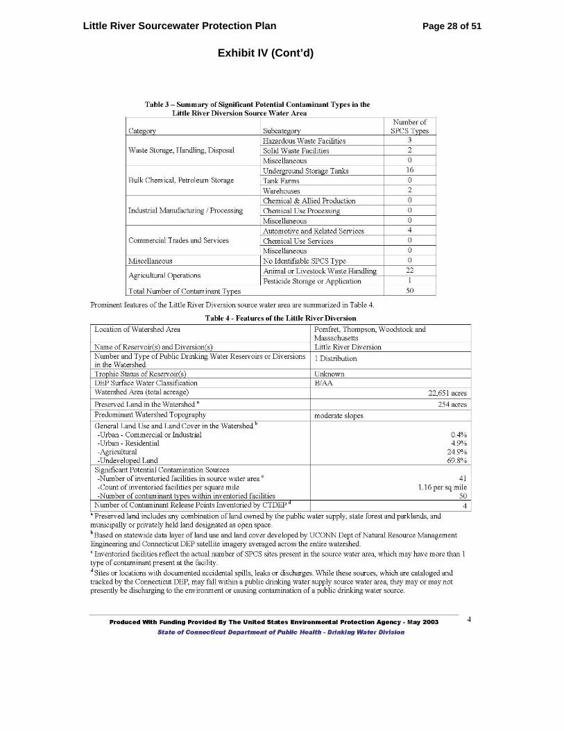
6.1 Summary of DPH Potential Contaminant Source Inventory The PCS inventory identifies potential threats to the drinking water source. The table below is excerpted from the DPH Sourcewater Assessment and lists the potential contaminant types and number in the Little River sourcewater protection area. Category Subcategory Number of
PCS Types
Waste Storage, Handling, Disposal Hazardous Waste Facilities 3 Solid Waste Facilities 2 Miscellaneous 0
Bulk Chemical, Petroleum Storage Underground Storage Tanks 16 Tank Farms 0 Warehouses 2
Industrial Manufacturing/Processing Chemical & Allied Production 0 Chemical Use Processing 0 Miscellaneous 0
Commercial Trades and Services Automotive and Related Services 4 Chemical Use Services 0 Miscellaneous 0
Miscellaneous No Identifiable PCS Type 0
Agricultural Operations Animal/Livestock Waste Handling 22 Pesticide Storage or Application 1
Total Number of Contaminant Types 50
6.2 Update of Potential Contaminant Source Inventory By and large the PCS inventory included in the CT Sourcewater Assessment is representative of the threats to the watershed. An effort is ongoing to verify the sources listed there. Preliminary results indicate a somewhat reduced number of agricultural sources (17 vs 22) and most Underground Storage Tanks listed have been cleaned up. The old landfill is closed, remediation at Linemaster has been completed and Rogers Corporation and Crabtree and Evelyn no longer discharge wastewater.

Little River Sourcewater Protection Plan Page 13 of 51
7 Assessment of Threats
7.1 Confirmed Contaminant Detects of Concern in Sourcewater Routine monitoring by the Putnam WPCA has detected nitrates in Roseland Lake, Shepherds Pond and several feeder streams. Nitrites and sodium have also been detected in some areas. Monitoring samples required by the Connecticut Department of Public Health (DPH) of all public water systems has detected the presence of nitrate in ten public wells (three community water systems (CWS), three Non-Transient Non-Community systems (NTNC) and four Transient Non-Community systems (TNC). Trichloroethylene was been detected in one well, VOCs in one, and coliforms in another (see Exhibit III). Detection of these contaminants indicates that they have been released to surface and ground waters and are a threat to the Little River watershed.
7.2 Roadways Roadways present a significant threat to drinking water sources. The possibility of an accident involving a truck transporting bulk shipments of hazardous materials poses a risk. Roadways are also a potential source of contamination due to potential petroleum leaks from vehicles; the application of road salts, which could cause elevated levels of sodium and chlorides; and maintenance activity which may include herbicide and pesticide applications.
7.3 On-Site Septic Systems On-site septic systems represent potential sources of nitrates, chlorides, bacteria and viruses. In addition, if improperly used, such as for disposal of paints, solvents, petroleum products and other hazardous waste, they could be a source of organic compounds.
7.4 Land Use
7.4.1 Industrial Industrial operations commonly use toxic substances as part of manufacturing, warehousing, and/or distribution. Chemicals, petroleum, cleaning supplies, machinery, metals, electronic products, asphalt, and others pose a potential threat to the water supply and must be managed. The potential contamination inventory for the Little River watershed identified three industrial sites in the Source Water Protection Area (SWPA). The water sources in the SWPA are vulnerable to contamination from these facilities involved in the manufacturing and using toxic substances.
7.4.2 Commercial Many commercial operations use toxic and hazardous materials in their processes. Examples include:
Auto repair shops, gas stations, car washes, paint shops Road maintenance depots, de-icing operations

Little River Sourcewater Protection Plan Page 14 of 51
Construction areas Dry cleaners, Laundromats Medical institutions, research laboratories, photography establishments,
printing facilities Restaurants, bakeries Woodworking and finishing facilities
The storage, use, and disposal of chemicals required by these operations can pose a potential threat to water since even small amounts of the hazardous materials can contaminate large amounts of surface or ground water. Storing quantities of the material can also create a serious problem if they are not contained and stored properly. Leaks and spills from storage tanks and pipes can contaminate water, rendering the water unfit for consumption.
7.4.3 Residential Residential contamination threats to surface or groundwater, if taken on a case-by-case basis, are normally less than other land use contamination, but in the aggregate, form a significant source of contamination. Most citizens are unaware of the effects of numerous potential contaminants stored, used, and disposed of from residential homes. The potential contaminants include:
Household chemicals Automotive products Paint/solvents Fuel storage systems On-site septic/sand mound systems Lawn/garden chemicals Abandoned wells
7.4.4 Agricultural and Golf Courses Improperly applied chemicals such as pesticides, fungicides and fertilizers can leach through the soil into the groundwater or run off into streams and can present a contamination threat to drinking water supplies. When stored in containers, there is the potential of leaks from the storage area into the ground. Manure storage facilities and manure/septage sludge spreading can also lead to high levels of E-Coli and nitrate levels within surface and groundwater due to runoff. Open agricultural and golf course land is also attractive to geese which have become an increasing problem in Connecticut due to the run-off of nutrients and bacteria from their waste. There are substantial agricultural areas and two golf courses within the Little River SWPA and, as a whole, the water source is vulnerable to contamination from them.
Little River Sourcewater Protection Plan Page 15 of 51
7.5 Anthropogenic (Man Made) Potential Contaminant Sources
7.5.1 Hazardous Waste Sites The primary concern with facilities that generate or use hazardous materials is that leaks, spills, or improper disposal could allow contaminants to be discharged into the ground. Three facilities within the Little River SWPA use or generate hazardous waste.
7.5.2 Underground Storage Tanks Fuel oil tanks represent a potential source of petroleum products, as well as chemical additives that may be present in the fuel. The potential threat of contamination from this source would be from a leak, overfill, or spill. The Little River SWPA contains both known Leaking Underground Storage Tanks (LUST) and potential Underground Storage Tanks (UST) sources of petroleum contamination. The Little River system is vulnerable to contamination from Underground Storage Tanks located within the SWPA.
7.6 Point Sources of Pollution Point sources refer to discharges that enter surface waters through a pipe, ditch, or other well-defined point of discharge. The term applies to wastewater and storm water discharges from a variety of sources. Wastewater point source discharges include municipal and industrial wastewater treatment plants and small domestic wastewater treatment systems that may serve schools, commercial offices, residential subdivisions and individual homes. The primary pollutants associated with point source discharges are oxygen-demanding waste, nutrients, sediment, color and toxic substances including chlorine, ammonia, and metals. Point source dischargers in Connecticut must apply for and obtain a National Pollutant Discharge Elimination System (NPDES) permit from the CT DEP. Two permits had been issued previously and have expired. As of the date of this report, there are no active NPDES permits within the Little River SWPA.
7.7 Non-Point Sources of Pollution Non-point sources are described as dispersed contamination from many sources such as soil erosion, on-lot septic systems, storm water discharges, agricultural activities, geese, and pollution associated with resource extraction and silviculture. The most significant contamination associated with non-point sources is nitrates associated with the use of manure, fertilizer, and pesticides which drain into streams and infiltrate into ground water. Household hazardous and commercial/industrial waste (e.g., ammonia, chlorides, paint, paint thinners, waste oil, antifreeze, solvents, etc.), which are sometimes discharged into on-lot septic systems, are also sources of non-point pollution. The potential risk from non-point sources makes the Little River system vulnerable to contamination.

Little River Sourcewater Protection Plan Page 16 of 51
Erosion during construction is a significant source of non-point pollution.
7.8 Stormwater Management The need to manage stormwater is created by increased land development since impervious surfaces prevent rain from soaking into the soil and allow pollutants to accumulate. Stormwater management, which has only been a subject of concern for the past ten to fifteen years, focuses on controlling the volume and peak discharge rate which increase dramatically when impervious surfaces cover an area. Connecticut requires municipalities to develop a stormwater management plan however Woodstock has obtained a waiver due to the low level of development.
7.9 Potential Future Sources Undeveloped land areas represent the potential for future contamination sources. There are significant undeveloped land areas within the SWPA (see Exhibit V for Land Use map). These include areas zoned for Industrial and commercial land-uses. Based on the amount of undeveloped land within the SWPA, there exists the possibility for future contamination.

Little River Sourcewater Protection Plan Page 17 of 51
8 Management Plan
8.1 Comprehensive Evaluation of the Watershed In order to effectively protect the Little River watershed it is necessary to have a comprehensive picture of the health of impoundments and tributaries and be able to zero in on sources of pollution. Many agencies have done testing with a specific, narrow intent. These include the USGS, CT DEP, Putnam WPCA, the Northeast District Department of Health (NDDH), and Aquatic Control Technologies. These tests are not part of an overall plan and the data is not centrally accessible. As part of this plan, the NDDH has agreed to sample and test surface water at 16 points within the watershed over four seasons to better understand the health of the streams and identify reaches that are the most adversely impacted. The team will develop a GIS database of the data and will collect and input additional data as resources allow. The data will be made available to the DEP, USGS and others to coordinate protection and cleanup efforts more effectively. The team encourages those agencies to coordinate their work in the Little River watershed with the Sourcewater Protection Steering Committee (see Section 8.8). The Team will coordinate with the Audubon Society’s Citizen Science Coordinator, Paula Coughlin, to do steam walks and rapid bio-assessments in some of the streams being sampled above to obtain addition data.
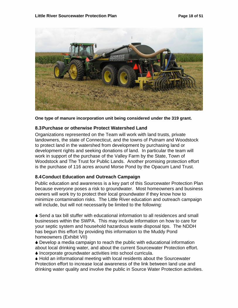
8.2 Agricultural Best Practices There are 37 agricultural sites in the watershed and 17 of them raise livestock. The control of nutrient runoff from manure handling and cropland fertilizing operations is one of the keys to decreasing the level of nitrogen compounds in the streams and ponds. The team encourages the farming community to continue to work with the E. CT Conservation District, FSA, NRCS, CT Farm Bureau and UConn Extension to implement best practices for handling manure, chemical fertilizers and pesticides. To promote and advance agricultural best practices, the Team has applied for an FY 2006 319 Grant to study the effectiveness of liquid manure incorporation to reduce nutrient runoff. Under the lead of the Eastern Connecticut Conservation District, the grant will select and lease (or purchase) a manure incorporation unit. Participating farmers, who already use liquid manure, will be trained on the machinery and use it on fields selected for the steepness of their slopes and/or proximity to streams. A sampling and testing regimen will be developed to measure the effectiveness of the unit in reducing the loss of nutrients to runoff. Assuming a positive response from the DEP in early 2006, the Team will prepare a detailed workplan and then begin work when funding is available in late 2006. A copy of the grant application is attached as Exhibit VI.
Little River Sourcewater Protection Plan Page 18 of 51
One type of manure incorporation unit being considered under the 319 grant.
8.3 Purchase or otherwise Protect Watershed Land Organizations represented on the Team will work with land trusts, private landowners, the state of Connecticut, and the towns of Putnam and Woodstock to protect land in the watershed from development by purchasing land or development rights and seeking donations of land. In particular the team will work in support of the purchase of the Valley Farm by the State, Town of Woodstock and The Trust for Public Lands. Another promising protection effort is the purchase of 116 acres around Morse Pond by the Opacum Land Trust.
8.4 Conduct Education and Outreach Campaign Public education and awareness is a key part of this Sourcewater Protection Plan because everyone poses a risk to groundwater. Most homeowners and business owners will work try to protect their local groundwater if they know how to minimize contamination risks. The Little River education and outreach campaign will include, but will not necessarily be limited to the following:
Send a tax bill stuffer with educational information to all residences and small businesses within the SWPA. This may include information on how to care for your septic system and household hazardous waste disposal tips. The NDDH has begun this effort by providing this information to the Muddy Pond homeowners (Exhibit VII)
Develop a media campaign to reach the public with educational information about local drinking water, and about the current Sourcewater Protection effort.
Incorporate groundwater activities into school curricula. Hold an informational meeting with local residents about the Sourcewater
Protection effort to increase local awareness of the link between land use and drinking water quality and involve the public in Source Water Protection activities.
Little River Sourcewater Protection Plan Page 19 of 51
8.5 Include Drinking Water Protection in Town Planning and Ordinances The team encourages the towns of Putnam and Woodstock to continue to keep sourcewater protection in the forefront when considering regulations and ordinances. Both towns would benefit by submitting a joint application to the DEP to declare the land along the Little River and its major tributaries an official greenway. This designation will offer an advantage in applying for DEP watershed protection grant monies, help Woodstock prioritize open space set-asides, and Putnam to secure funding to improve parklands a long the river. The towns should consider developing ordinances requiring homeowners to inspect and maintain septic systems at regular intervals and to have underground fuel storage tanks inspected and removed if failing. In addition, the towns should work to engage and educate developers regarding proper stormwater management during and after construction. Existing regulations should be aggressively enforced. The Town of Woodstock is encouraged to organize and support ongoing household hazardous waste collection days to prevent this material from being illegally dumped or disposed of in individual septic systems. The Towns of Putnam and Woodstock and the Putnam WPCA are encouraged to use the provisions of Connecticut statutes and regulations governing activities in public water supply watersheds, where appropriate, to protect the Little River system. Summaries of these are included as Exhibit VIII.
8.6 Support Efforts to De-list Roseland Lake Roseland Lake has been a recreational resource for the people of northeastern Connecticut and beyond for some 125 years. Roseland Park is a historically significant part of the culture of the area and the Team encourages the Trustees to maintain and improve it as a resource for the area and as a buffer along the lake. In particular they should continue the efforts begun by the ECCD to control invasive phragmites reeds. The Team will work with the DEP to find ways to remove the lake from the Impaired Waterbodies List. The Team will work with DPH to again allow swimming at the Lake by virtue of the fact that the swimming area is over 2 miles from the diversion at Peake Brook Road.
8.7 Muddy Pond Muddy Pond and Morse Pond are at the northern end of the watershed. Muddy Brook flows from Muddy Pond and is the longest tributary to the Little River. Muddy Brook and its tributaries (one of which flows from Morse Pond) are the major contributors to Roseland Lake and the Little River downstream. In addition Muddy Pond is the only public swimming area in the watershed and it has become infested with variable milfoil, an invasive species. This presents a unique opportunity to educate Woodstock residents to the importance of protecting the watershed. The Team requests that the town provide an interpretive sign explaining the importance of the watershed as a public water

Little River Sourcewater Protection Plan Page 20 of 51
supply and the dangers of invasive species and how to avoid introducing them. Information could include transport of invasive species by boats and releases from home aquariums. It is only a matter of time before milfoil migrates downstream and public awareness can help garner resources to fight this nuisance.
8.8 Form Sourcewater Protection Steering Committee The following persons comprise the Little River Sourcewater Protection Steering Committee. They are members of the team that developed this drinking water protection plan for their community, and are committed to implementing the prevention measures outlined above. Furthermore, this committee will meet at a minimum of once a year to review and update the plan and to assess its progress.
Mary Ellen Blake Muddy Pond Neighborhood Doug Cutler Putnam Town Administration John Guszkowski E. CT RC&D, Town of Woodstock Scott Gravatt E. CT Conservation District Maureen Marcoux Northeast District Department of Health Paul Miller Farmer Jean Pillo Woodstock Conservation Commission Sandy Rotival Woodstock Planning & Zoning Comm. Eric Thomas CT DEP Bill Trayner Putnam WPCA
9 Contingency Plan An Emergency Contingency Plan was prepared by the Putnam Water Pollution Control Authority as part of their current Water Supply Plan. Due to its size it is not reproduced here.

Little River Sourcewater Protection Plan Page 21 of 51
Exhibit I
[Passed June 2005]
RESOLUTION – WOODSTOCK BOARD OF SELECTMEN LITTLE RIVER SOURCE WATER PROTECTION PROGRAM
WHEREAS, the Little River Watershed, lying primarily in the Town of Woodstock, was designated as the public water supply area for the Town/City of Putnam by Special Act of the Connecticut General Assembly, and WHEREAS, A Plan of Open Space and Conservation for the Town of Woodstock cites the Little River Watershed/Putnam Water Supply as a high-priority area for water quality protection, and WHEREAS, the Woodstock Plan of Conservation and Development explicitly supports the goals of A Plan of Open Space and Conservation concerning protection of water supply watershed areas, and WHEREAS, the classifications for the Little River indicate that the raw water in the River presently does not meet the criteria for use as a public water supply without treatment and the land uses in the watershed upstream of the water treatment plan may be contributing to the degradation of the water supply, and WHEREAS, the compromised water quality in many of the watercourses and waterbodies in the Little River watershed have reduced the opportunity for passive and active recreation, including fishing and swimming, and WHEREAS, the U.S. Department of Agriculture has identified the Little River as a priority candidate for the Department’s Source Water Protection Program, and WHEREAS, the Nonpoint Source Management Program of the Federal Clean Water Act has identified four of the water bodies in the Little River Watershed as priorities for the development of watershed-based plans and restorative activities, BE IT THEREFORE RESOLVED, that the Woodstock Board of Selectmen in joint cooperation with the Putnam Board of Selectmen does support the efforts of the Little River Source Water Protection team to collaborate in the development of a Source Water Protection Plan, and BE IT FURTHER RESOLVED, that the efforts of the local team will develop the following as part of the plan for presentation and approval of the towns’ Boards of Selectmen, including any proposed requests for grant funding: a map outlining the impacted area; an inventory of potential contaminant sources; a definition of areas that match up with entities and organizations; a definition of voluntary measures that may be initiated; identification of public education initiatives; and identification of entities and resources that will facilitate implementation of the plan and its sustainability.

Little River Sourcewater Protection Plan Page 22 of 51
Exhibit I (Cont’d)
[Passed July 2005]
Resolution – Putnam Board of Selectmen Little River Source Water Protection Program
WHEREAS, the Little River Watershed by Special Act of the Connecticut General Assembly was designated as the public water supply area for the Town of Putnam, and WHEREAS, the Putnam Water Pollution Control Authority maintains and operates the Little River Diversion as a source of the town’s public drinking water, and WHEREAS, the classifications for the Little River indicate that the raw water in the river presently does not meet the criteria for use as a public water supply without treatment and land uses in the watershed upstream of the water treatment plant may be contributing to the degradation of the water quality, and WHEREAS, the town’s draft Plan of Conservation and Development identifies the Little River for special protection and expansion of a greenway network, and WHEREAS, the Connecticut Department of Health has evaluated the susceptibility of the Little River to contamination and finds that it has an overall High risk of contamination from identified potential sources of contamination, and WHEREAS, the U.S. Department of Agriculture has identified the Little River as a priority candidate for the Department’s Source Water Protection Program, and NOW, THEREFORE, BE IT RESOLVED, that the Putnam Board of Selectmen in joint cooperation with the Woodstock Board of Selectmen does support the efforts of the Little River Source Water Protection team to collaborate in the development of a Source Water Protection Plan and that Mayor Daniel S. Rovero is authorized to appoint members, including representatives of the Water Pollution Control Authority, the Planning Commission, and the Recreation Department; to the team to assure an appropriate number of Putnam representatives participate in developing the Source Water Protection Plan, and BE IT FURTHER RESOLVED, that the efforts of the local team will develop the following as part of the plan for presentation and approval of the towns’ Boards of Selectmen, including any proposed requests for grant funding: a map outlining the impacted area; an inventory of potential contaminant sources; a definition of areas that match up with entities and organizations; a definition of voluntary measures that may be initiated; identification of public education initiatives; and identification of entities and resources that will facilitate implementation of the plan and its sustainability.

Little River Sourcewater Protection Plan Page 23 of 51
Exhibit II

Little River Sourcewater Protection Plan Page 24 of 51
Exhibit III
Public Water Systems in the Little River Watershed
PWSID SYSTEM NAME POP
SERVED Susceptibility Contaminants Detected
Community Systems
CT1160011 PUTNAM WATER POLLUTION CONTROL AUTHORITY 8971 High N/A CT1698051 BIRMINGHAM UTIL - CORNFIELD POINT DIV. 95 High Nitrates CT1699011 BROOKWOOD APARTMENTS - SYSTEM #1 30 High Nitrates, TCE CT1690021 ROSELAND TERRACE ASSOCIATION 100 Medium Nitrates CT1690031 WOODSTOCK HOUSING AUTHORITY 26 Low None CT1698011 WOODSTOCK MEADOWS CONDOMINIUM ASSN. 180 Low None Non-Transient Non-Community CT1691163 CRABTREE & EVELYN 25 Low None CT1691153 FIRST CONGREGATIONAL CHURCH OF WOODSTOCK 60 Medium Nitrates CT1699043 HERITAGE CORNER, LLC 32 Medium None CT1691173 HYDE SCHOOL - SYSTEM #1 (SCHOOL) 310 High None CT1690442 LINEMASTER SWITCH CORP 170 Low None CT1690432 ROGERS CORP - PORON WELL 90 Low Nitrates CT1691112 WOODSTOCK ACADEMY 1063 Low Nitrates CT1690262 WOODSTOCK ELEMENTARY SCHOOL 636 High VOCs CT1699023 WOODSTOCK MIDDLE SCHOOL 511 Medium None Transient Non-Community CT1690334 CINNAMON TREE BAKERY 25 Low None CT1690084 EVANGELICAL COVENANT CHURCH 25 Low Nitrates CT1690094 HARRISVILLE GOLF COURSE 29 Medium None CT1690104 INN AT WOODSTOCK HILL 49 Medium None CT1690284 LITTLE RIVER PLAZA 25 Medium Nitrates CT1690184 ROSELAND PARK GOLF COURSE 25 Low Nitrates CT1690214 SOUTH WOODSTOCK BAPTIST CHURCH 25 Low Nitrates CT1690124 SWEET EVALINAS STAND 42 Low Coliforms CT1690264 WOODSTOCK FAIR 25 Medium None CT1696282 WOODSTOCK TOWN HALL 33 High None

Little River Sourcewater Protection Plan Page 25 of 51
Exhibit IV

Little River Sourcewater Protection Plan Page 26 of 51
Exhibit IV (Cont’d)

Little River Sourcewater Protection Plan Page 27 of 51
Exhibit IV (Cont’d)
Little River Sourcewater Protection Plan Page 28 of 51
Exhibit IV (Cont’d)

Little River Sourcewater Protection Plan Page 29 of 51
Exhibit V

Little River Sourcewater Protection Plan Page 30 of 51
Exhibit VI
Connecticut Department of Environmental Protection 79 Elm Street
Hartford, CT 06106-5127
FY2006 Application – Work Plan for the Nonpoint Source Management Grant Program
Funded under Section 319 (h) of the Federal Clean Water Act
(Form created March 2005)
Proposals may be submitted by any interested Connecticut public or private organization, including municipalities, nonprofit environmental organizations, regional water authorities/planning agencies, and watershed associations. Proposals submitted in response to the FY2006 RFP must be postmarked or received electronically by August 31, 2005 Proposals postmarked or received electronically after August 31, 2005 will not be considered for FY2006 funding. Please use this form when submitting a proposal. You may attach additional information or documentation to the proposals. Project proponents whose proposals are selected for potential funding may need to submit a final work plan. For questions or additional assistance call Stan Zaremba at (860) 424-3730. Important note: DEP may require each successful applicant to provide additional information in a final work plan to ensure that each project is sufficiently documented.
Little River Sourcewater Protection Plan Page 31 of 51
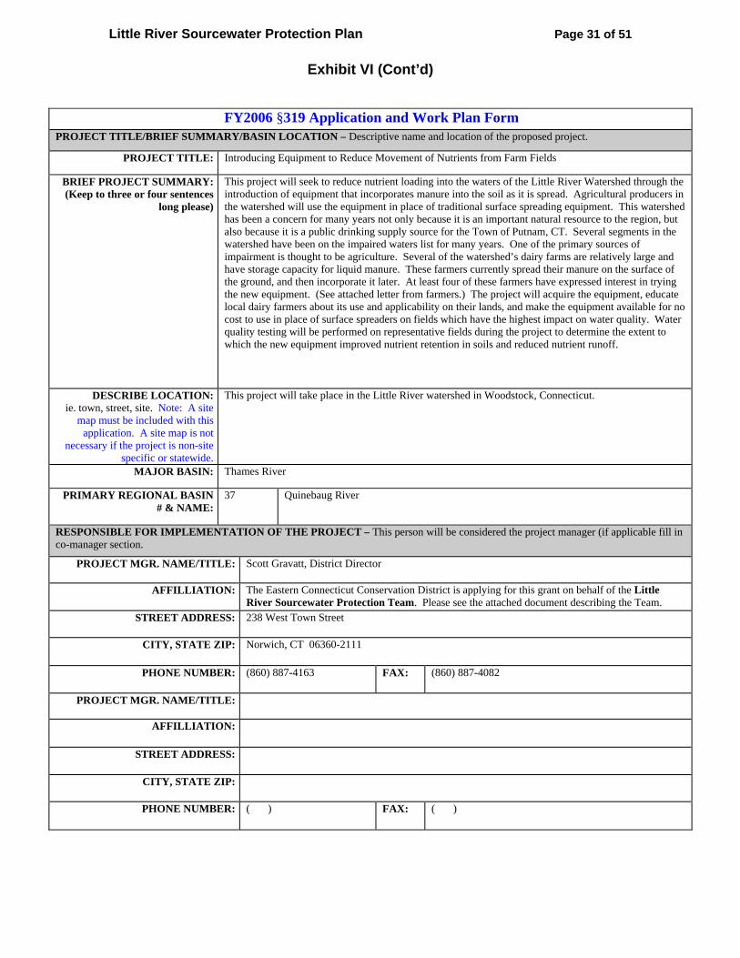
Exhibit VI (Cont’d)
FY2006 §319 Application and Work Plan Form PROJECT TITLE/BRIEF SUMMARY/BASIN LOCATION – Descriptive name and location of the proposed project.
PROJECT TITLE: Introducing Equipment to Reduce Movement of Nutrients from Farm Fields
BRIEF PROJECT SUMMARY: (Keep to three or four sentences
long please)
This project will seek to reduce nutrient loading into the waters of the Little River Watershed through the introduction of equipment that incorporates manure into the soil as it is spread. Agricultural producers in the watershed will use the equipment in place of traditional surface spreading equipment. This watershed has been a concern for many years not only because it is an important natural resource to the region, but also because it is a public drinking supply source for the Town of Putnam, CT. Several segments in the watershed have been on the impaired waters list for many years. One of the primary sources of impairment is thought to be agriculture. Several of the watershed’s dairy farms are relatively large and have storage capacity for liquid manure. These farmers currently spread their manure on the surface of the ground, and then incorporate it later. At least four of these farmers have expressed interest in trying the new equipment. (See attached letter from farmers.) The project will acquire the equipment, educate local dairy farmers about its use and applicability on their lands, and make the equipment available for no cost to use in place of surface spreaders on fields which have the highest impact on water quality. Water quality testing will be performed on representative fields during the project to determine the extent to which the new equipment improved nutrient retention in soils and reduced nutrient runoff.
DESCRIBE LOCATION: ie. town, street, site. Note: A site
map must be included with this application. A site map is not
necessary if the project is non-site specific or statewide.
This project will take place in the Little River watershed in Woodstock, Connecticut.
MAJOR BASIN: Thames River
PRIMARY REGIONAL BASIN # & NAME:
37 Quinebaug River
RESPONSIBLE FOR IMPLEMENTATION OF THE PROJECT – This person will be considered the project manager (if applicable fill in co-manager section.
PROJECT MGR. NAME/TITLE: Scott Gravatt, District Director
AFFILLIATION: The Eastern Connecticut Conservation District is applying for this grant on behalf of the Little River Sourcewater Protection Team. Please see the attached document describing the Team.
STREET ADDRESS: 238 West Town Street
CITY, STATE ZIP: Norwich, CT 06360-2111
PHONE NUMBER: (860) 887-4163 FAX: (860) 887-4082
PROJECT MGR. NAME/TITLE:
AFFILLIATION:
STREET ADDRESS:
CITY, STATE ZIP:
PHONE NUMBER: ( ) FAX: ( )

Little River Sourcewater Protection Plan Page 32 of 51
Exhibit VI (Cont’d)
ESTIMATED TOTAL COST AND NONFEDERAL SOURCES – Identify the amount of §319 funds requested (60%); nonfederal match (40%); and total cost of project (100%).
To calculate the amounts use the following : Section 319 funds requested divided by .6 = Total cost Total cost – Section 319 funds requested = 40% nonfederal match
60% -§ 319 FUNDS REQUESTED: $57,000.00
40% - NONFEDERAL MATCH: $38,000.00
100% TOTAL COST: $95,000.00
PREVIOUS 319 FUNDING AWARDED TO GROUP? If yes, indicate below project name and fiscal year, award amount, and balance to date.
YES NAME OF PROJECT:
EXPECTED COMPLETION DATE:
$ AMT AWARDED:
$ BALANCE TO DATE:
NO §319 FUNDS HAVE NOT BEEN PREVIOUSLY AWARDED TO APPLICANT.
NOTE TO THOSE APPLICANTS PROPOSING IMPLEMENTATION OR RESTORATION ACTIVITIES: According to federal guidelines, a watershed-based plan must be developed for the water body in question before implementation activities can be funded by § 319 funds. You will need to provide the following information in order to satisfy that requirement, consistent with guidance at: http://www.epa.gov/fedrgstr/EPA-WATER/2003/October?Day-23/w26755.htm Please consult with DEP as to the level of commitment required to develop the watershed-based plan before implementation/restoration activities can begin.
IMPAIRMENT Identify causes and sources of nonpoint source impairment(s). Three waterbodies within the Little River
watershed (above the Putnam WPCA diversion) are listed as impaired on the 2004 303d list. They are Roseland Lake and segments of Muddy Brook and North Running Brook. Muddy Brook is the main tributary flowing into Roseland Lake, which has had extensive algal blooms for many years. A definitive source of the nutrients in this system has not been identified, however a 2000 – 2001 USGS study of the Quinebaug Basin noted elevated levels of nitrogen (above 1.0 mg/L) and phosphorus (above 0.1.mg/L) at the mouth of the Little River. The report states, “The elevated concentrations at the station on the Little River reflect the contribution of nonpoint sources of nutrients from the Little River drainage area, which contains 24 percent agricultural land.” Between 1985 and 2002 only 0.8% of the land in Woodstock was lost to development. Therefore development does not explain the elevated levels of nutrients seen in the USGS study. In addition, there are no municipal wastewater discharges, or major industrial or commercial sources of nutrients in the watershed. Lacking more definitive studies of the watershed, the conclusion is that agricultural sources are the prime source of nutrient loading to the waterbodies in the watershed. There are 2,400 acres of cropland in the watershed where runoff may contribute nutrients to the system.
LOAD REDUCTION Estimate expected load reductions and whether the impairment is fully addressed. Based on available literature there is an anticipated reduction of at least 50% in N and P runoff on the fields where the equipment is to be used. Based on the rate at which the equipment can spread manure, and allowing for transportation, etc., it is estimated that the equipment can be used to apply manure to approximately 400 acres of cropland during the prime manure spreading times, which occur three times a year: 1) Spring; 2) Between first and second cuttings of hay; and 3) Fall.

Little River Sourcewater Protection Plan Page 33 of 51
Exhibit VI (Cont’d)
MANAGEMENT MEASURES Describe the specific nonpoint source management measures to be applied. Nutrient load reduction will be accomplished primarily through the utilization of equipment which both applies manure and incorporates it into the soil. An attached map shows the large portion of the watershed occupied by farm fields. The equipment will be used on fields that have been prioritized based on the likelihood of nutrient runoff. The equipment will be used in place of the traditional system of surface application followed by incorporation at a later time. This technique shift will allow manure and nutrients to be immediately incorporated into soils, increasing nutrient retention in soils and reducing nutrient runoff into waterbodies. An additional measure that will occur as a result of this project will be that the manure spreading will be calibrated, thus there will be reliable information regarding how much manure is being spread per acre.
TECH ASSISTANCE & FINANCIAL ASSISTANCE
Estimate needed technical and financial assistance by activity. Technical assistance required is primarily in the area of developing and implementing a monitoring and testing regimen under an approved QAPP. Financial assistance will be required to lease the manure application equipment. The QAPP/monitoring activity and the lease of equipment total approximately $50,000 and will require a cash match of approximately $20,000 dollars. We have preliminary commitments from the Putnam WPCA, Town of Putnam and the Roseland Lake Trustees to provide that match. Remaining activities will be matched by in-kind labor provided by the Eastern Connecticut Conservation District, local farmers and employees of the Towns of Woodstock and Putnam. In addition, other organizations represented on the Little River Sourcewater Protection Team have agreed to assist as needed. (See attached list of Team members.)
PUBLIC INFORMATION & EDUCATION
Describe public information and education efforts and their value to the project. Public information and outreach is a cornerstone of this project. Part of the grant is earmarked for developing an education and outreach program to provide information to residents, farmers and water system consumers about the project and its findings. The public will also be reached through the efforts of the organizations represented on the Little River Sourcewater Protection Team. (See attached list of Team members.) The value of the outreach will be to raise awareness in the pubic of the impairments to local waterbodies and to encourage other grass roots efforts to address them. It will also demonstrate to the dairy farming community a cost effective method of spreading manure where it is needed and without losing valuable nutrients to the air and runoff.
MANAGEMENT MEASURES Provide an implementation schedule for NPS management measures. Equipment will be obtained shortly after the funds become available. The equipment will be utilized during the first possible manure application season, most likely spring of 2007. A water quality monitoring contractor will conduct testing after application, doing a side-by-side comparison with the traditional method of manure application. The schedule for the monitoring will be established by the QAPP. The tentative plan is to use the equipment for 2 years. Educational outreach will be ongoing, but will be culminated with a workshop near the end of the project to present the results of the project and promote the method, if it is successful.
MILESTONES List the measurable milestones consistent with the implementation schedule. Milestones will be: Select the equipment; Prioritize and select fields; Develop schedule; Obtain equipment; Year 1: Utilization at Farm #1; Utilization at Farm #2; (etc).; Water quality monitoring; Year 2: Repeat utilization and monitoring; Farmer and public education/outreach.
PERFORMANCE Provide a list of performance criteria that will be used to measure success. Performance criteria to be considered include: Successful operation of equipment in the soils of the region Measured reduction in nutrient runoff Acceptance of method and equipment by farmers Cost of equipment, maintenance and repairs are acceptable to farmers

Little River Sourcewater Protection Plan Page 34 of 51
Exhibit VI (Cont’d)
MONITORING Discuss how you plan on monitoring your project. The Little River Sourcewater Protection Team will work together to accomplish the tasks, with the Eastern Connecticut Conservation District (ECCD) acting as the facilitator and organizer. The team will hold quarterly meetings and quarterly reports will be filed. A contractor/consultant will develop a QAPP and conduct water quality sampling and analysis as part of the project. The work of the contractor will be monitored by ECCD and/or other Team members.
CONSTRUCTION PROJECT/LONG TERM MAINTENANCE
If the project includes construction who is responsible for long-term maintenance? Not applicable.
INTERAGENCY COORDINATION, ROLES, AND RESPONSIBILITIES – Describe participation and commitments expected from other agencies and organizations. The primary impetus for this project was a broad, interagency, public-private coordination effort known as the Little River Sourcewater Protection Team. See the attached list of agencies, organizations and individuals represented on this Team. The Boards of Selectmen from both towns have passed resolutions supporting the work of this Team to improve water quality in the watershed (see attached). The Team will act as primary managers of the project, with support from the Eastern Connecticut Conservation District, who will provide administrative and other services. The Little River Sourcewater Protection Team will also cooperate with the CT Department of Public Health and the Town of Putnam to coordinate this project’s implementation and public outreach efforts with the mission to implement targeted source water protection efforts within the Town of Putnam's Little River Diversion watershed, as a result of the 2003 Connecticut Source Water Assessment Program report. This project will also compliment work currently being funded through NRCS and FSA to manage agricultural wastes in the watershed. QUALITY ASSURANCE QUALITY CONTROL – Will this project require a quality assurance quality control plan (QAPP).
YES NO If your proposed project involves the collection, analysis, or manipulation of environmental data and it is selected for funding, it will require a Quality Assurance Project Plan (QAPP). The QAPP must be approved by CT DEP/US EPA prior to the commencement of this work. Investigators need to include the preparation and implementation of this plan into their budget All QAPP’s should be written according to one of the following guidance documents : http://www.epa.gov/quality1/qa docs.html
• EPA Requirements for Quality Assurance Project Plans EPA QA/R-5, EPA/240/B-01/003, March, 2001
guidance documents, and will be determined on a case-by-case basis. Also note:
1. The use of "secondary data" to make environmental decisions requires a QAPP. Secondary data are previously collected data (which may have been collected by other entities, not just the current grantee). A good example is the use of previously collected data in a computerized model to develop new data, e.g., about estimated pollutant levels. This might fall under your "manipulation" criterion.
2. If project proponent provides "in kind" services, such as sample analysis or sample collection, instead of money, a QAPP is necessary. 3. If the project is conducted with the deliberate intent to provide the data to EPA for its use, a QAPP should be written.
TASKS, DELIVERABLE, ESTIMATED COST – List in sequence the major tasks, deliverables, and costs. A final project report is a required deliverable for every project identify, as appropriated, any contracts to be awarded or Quality Assurance Project Plan (QAPP) plans as tasks. Any type of data analysis or data reporting will require a QAPP. Task # Description of Task & Deliverable Cost
§ 319 funds 1 Team (including cooperating farmers) researches equipment options; evaluates equipment through actual
demonstrations (likely to be in the State of NY); conducts cost/performance analysis; and calculates the # of acres the equipment can cover. Deliverable - Select equipment to be obtained.
3900

Little River Sourcewater Protection Plan Page 35 of 51
Exhibit VI (Cont’d)
2 Evaluate the fields of the participating farmers, determine which fields are appropriate for the equipment selected, and prioritize the fields based on proximity to impaired waters, slope, soil type, etc. Deliverable - Prioritized list of fields where manure will be applied using the equipment.
3600
3 Coordinate the sharing of the equipment between participating farmers, making every effort to maximize use. Deliverable - A written plan, agreed to by the farmers, establishing a sharing schedule and transportation responsibilities.
3600
4 Obtain equipment. The Team's preferred option: A 2 year lease, with the option for one or more of the farmers to purchase the equipment at the end of the lease period. Deliverable - Acceptable agreement with dealer to obtain equipment, and delivery of the equipment to Woodstock, CT.
21,000
5 The equipment will be utilized by several farmers in the watershed to spread and incorporate manure on the pre-selected fields on each farm. It is planned that each farmer will be allowed to use the equipment for several days during the prime manure spreading seasons, according to the schedule. The equipment will be used outside of the prime spreading seasons as desired/scheduled. Alternative – Employ a Commercial Applicator to operate the equipment on all participating farms. Deliverable – Utilize the equipment on at least three farms to apply and incorporate manure on selected farm fields for one to two years.
5400
6 Using a qualified consultant/contractor, develop a QAPP and execute the plan to monitor the water quality in the vicinity of selected fields to determine the impact of using the equipment. Tentative plan is to select several fields for sampling, and use the new equipment on one portion of each and the traditional method on the other portion, then conduct a side-by-side comparison of the nutrient runoff from the two portions. Deliverable - Report presenting the results of the water quality monitoring.
9000
7 The equipment will be maintained, repaired, and stored. The participating farmers will preform minor maintenance and repair. If more serious repairs become necessary, they may be performed by employees at the Woodstock Town garage, or by a private business hired to do the work. Storage arrangements will be made through one of the Team members. Storage locations under consideration include Roseland Park, Woodstock Fairgrounds, Woodstock Town Garage, one or more of the participating farms, and ECCD property. Deliverable - Maintain, repair, and store equipment.
3300
8 An important part of this grant will be to use the project and the connections made possible by the extensive membership of the Little River Sourcewater Protection Team to educate both farmers and the public concerning the importance of protecting the watershed and new methods which can be employed to reach that goal. Deliverable – Provide outreach literature and conduct a workshop to present the results of the project and promote the use of the equipment, if deemed appropriate by the results.
2400
9 Quarterly and Final Reports 4800
Estimated duration (How many months do you expect project to run - up to 2 year duration): Estimate is 24 months
PUBLIC PARTICIPATION – Describe how this will be accomplished.
Public participation has already begun, as this application is the outgrowth of a local citizen team’s work to develop a sourcewater protection plan for the Little River watershed. The effort is lead by Atlantic States Rural Water & Wastewater Association and the team has members who represent a wide cross-section of the community. See attached list of organizations and their representative on the Little River Sourcewater Protection Team. Efforts will continue through outreach to the public and the farming community.

Little River Sourcewater Protection Plan Page 36 of 51
Exhibit VI (Cont’d) FY2006 ESTIMATED BUDGET SHEET
Are §319 funds being used for salaries? YES – fill out §319 salary section. NO - skip to Match salary section.
§319 SALARY INFORMATION: NAME TITLE ANNUAL
SALARY APPROX. % OF TIME
SALARY CHARGED TO PROJECT
% OF FRINGE
TOTAL
Scott Gravatt District Director $50,000 20% $10,000 $10,000 Greg Smith Nat. Resource
Specialist $34,000 5% $ 3,400 $ 3,400
Kate Johnson Administrative Specialist
$31,000 5% $ 1,550 $ 1,550
Farmers 1% $ 7,500 $ 7,500 STATE/LOCAL/OTHER MATCH SALARY INFORMATION: NAME TITLE ANNUAL
SALARY APPROX. % OF TIME
SALARY CHARGED TO PROJECT
% OF FRINGE
TOTAL
Town employees 1% $10,800 $10,800
Total Project
Costs 100% §319 Costs
60% State/local
/ other Match 40%
Salary & Fringe Includes salaries and fringe benefits paid for work performed on the project. “Salary” should reflect the rate per hour, by position. An employment benefit given in addition to one’s wages or salary.
$33,250 $19,950 $13,300
Indirect Cost of Salary
Indicate the indirect costs. Typical indirect costs are associated with but are not limited to office space, telephones, personnel administration, accounting, and room or equipment rental and usage (i.e., the cost of doing business).
$5,000 $3,000 $2,000
Supplies Includes office/field/lab supplies, data processing materials, books, paper and other office supplies, clothing, Include equipment costing less than $1,000 in total.
$2,500 $1,500 $1,000
Equipment Includes a single item of equipment costing more than $1,000 in total. (unit cost > $1,000 must be itemized below) *
$35,000 $21,000 $14,000
Travel and Training
Includes project-related charges for travel activities (travel, tolls), and charges as a result of use of an auto. Vehicle costs should be shown as the number of miles times the mileage rate being applied. Mileage rates (cost/mile) cannot exceed the rate approved by the Connecticut State Department of Administrative Services rates for in-state travel.
$4,200 $2,520 $1,680
Contractual Includes expenditures made to sub-grantees/sub-contractors, hired speakers, legal services, cost of engineering and design, etc. The rate of pay per hour, number of hours and type of service provided should be included. Any procured services not provided by the Sponsor should be listed here.
$11,300 $6,780 $4,520
Construction Costs (construction contracts, cost share agreements, etc.) associated with construction. Permit fees can be included.
Other (specify) Includes postage, printing, license fees, equipment maintenance and repair, computer software, non-staff insurance. (unit cost > $1,000 must be itemized below) *
$5,000 $3,000 $2,000
Totals $95,000 $57,000 $38,000
* List equipment > $1,000: Manure application machinery * List other expenses: Maintain and repair manure application machinery

Little River Sourcewater Protection Plan Page 37 of 51
Exhibit VI (Cont’d)

Little River Sourcewater Protection Plan Page 38 of 51
Exhibit VI (Cont’d) Confirmation of Farmer Interest The note below was presented to several farmers who met criteria that the Sourcewater Team believes will be factors in this project: a) They have fields within the watershed; b) They handle at least a portion of their manure in liquid form; and c) They typically transport their manure to the fields via a tractor-drawn spreader. The farmers were asked to sign the note to indicate they are interested in participating. Three farmers signed this note, and there is another who is interested but did not wish to sign a note at this time. This gives the project a core group to get started, and could lead to additional farmers showing interest. August 2005 To: Little River Sourcewater Protection Team From: Corn and Hay Growers in the Little River Watershed I am interested in learning more about equipment that incorporates manure as the manure is applied on the corn and hay fields. I would consider participating is a grant project that would make the equipment available to me to try on my farm. Signed by: Paul Miller Fairvue Farm 199 Rt. 171 Woodstock, CT 06281 David Morse Mayhill Farm P.O. Box 23 311 Dugg Hill Road E. Woodstock, CT 06244 Donald Hibbard Hibbard Hill Farm Dugg Hill Road Woodstock, CT 06281
(Mr. Hibbard qualified his signature with statements about when he spreads and bedding material.)

Little River Sourcewater Protection Plan Page 39 of 51
Exhibit VI (Cont’d) Little River Sourcewater Protection Team Background: The Little River Sourcewater Protection Team is a non-governmental committee of local organizations, municipalities, agencies, and citizens organized to prepare a plan of protection for the watershed that supplies drinking water to the town of Putnam, CT and overlies groundwater sources in Woodstock, CT. The Team is lead by the Sourcewater Protection Specialist from the Atlantic States Rural Water & Wastewater Association. His position is funded by the USDA and he is tasked with working with local communities to protect drinking water supplies that have been identified as susceptible to contamination. Susceptibility is based on Sourcewater Assessments of public drinking water supplies prepared by the CT DPH along with input from the USDA/NRCS, EPA, DEP and ASRWWA staff. The protection plan includes an inventory of potential contaminant sources, goals for protecting the water supply based on those threats, and recommendations for implementing protection measures to meet the stated goals. The Team has identified reduction of non-point sources of nutrients as a goal and this grant is an excellent opportunity to implement a management practice that has real promise to reduce nutrient runoff. Organizations Represented on the Team: Organization Represented by Atlantic States Rural Water & Wastewater Assoc Marc Cohen Audubon Society Andy Rzezinkiewicz Connecticut Dept. of Environmental Protection Eric Thomas E. CT Resource Conservation and Development John Guszkowski Eastern Connecticut Conservation District Scott Gravatt, Greg Smith Green Valley Institute Holly Drinkuth Local Builders Doug Porter Local Farmers Paul Miller Local Outdoor Recreation Business Ian MacRae Muddy Pond Neighborhood Mary Ellen Blake, Carol Berner Nature Conservancy Cyrus Harvey, Jr Northeast District Department of Health Maureen Marcoux Putnam Town Administration Doug Cutler Putnam Water Pollution Control Authority Bill Trayner Quinebaug-Shetucket Heritage Corridor Jean Cass Roseland Park Ed Higgins UConn Cooperative Extension Joyce Meader UDSA Natural Resources Conservation Service Nancy Ferlow Woodstock Conservation Commission Jean Pillo Woodstock Planning Department John Guszkowski Woodstock Planning & Zoning Commission Sandy Rotival Woodstock Town Administration Delpha Very Woodstock Water Pollution Control Authority Peter Ellsworth Wyndham Land Trust Dick Booth

Little River Sourcewater Protection Plan Page 40 of 51
Exhibit VI (Cont’d)
RESOLUTION – WOODSTOCK BOARD OF SELECTMEN LITTLE RIVER SOURCE WATER PROTECTION PROGRAM
WHEREAS, the Little River Watershed, lying primarily in the Town of Woodstock, was designated
as the public water supply area for the Town/City of Putnam by Special Act of the Connecticut General Assembly, and
WHEREAS, A Plan of Open Space and Conservation for the Town of Woodstock cites the Little River Watershed/Putnam Water Supply as a high-priority area for water quality protection, and WHEREAS, the Woodstock Plan of Conservation and Development explicitly supports the goals of A Plan of Open Space and Conservation concerning protection of water supply watershed areas, and WHEREAS, the classifications for the Little River indicate that the raw water in the River presently does not meet the criteria for use as a public water supply without treatment and the land uses in the watershed upstream of the water treatment plan may be contributing to the degradation of the water supply, and WHEREAS, the compromised water quality in many of the watercourses and waterbodies in the Little River watershed have reduced the opportunity for passive and active recreation, including fishing and swimming, and WHEREAS, the U.S. Department of Agriculture has identified the Little River as a priority candidate for the Department’s Source Water Protection Program, and WHEREAS, the Nonpoint Source Management Program of the Federal Clean Water Act has identified four of the water bodies in the Little River Watershed as priorities for the development of watershed-based plans and restorative activities, BE IT THEREFORE RESOLVED, that the Woodstock Board of Selectmen in joint cooperation with the Putnam Board of Selectmen does support the efforts of the Little River Source Water Protection team to collaborate in the development of a Source Water Protection Plan, and BE IT FURTHER RESOLVED, that the efforts of the local team will develop the following as part of the plan for presentation and approval of the towns’ Boards of Selectmen, including any proposed requests for grant funding: a map outlining the impacted area; an inventory of potential contaminant sources; a definition of areas that match up with entities and organizations; a definition of voluntary measures that may be initiated; identification of public education initiatives; and identification of entities and resources that will facilitate implementation of the plan and its sustainability.

Little River Sourcewater Protection Plan Page 41 of 51
Exhibit VI (Cont’d)
Resolution – Putnam Board of Selectmen Little River Source Water Protection Program
WHEREAS, the Little River Watershed by Special Act of the Connecticut General Assembly was designated as the public water supply area for the Town of Putnam, and WHEREAS, the Putnam Water Pollution Control Authority maintains and operates the Little River Diversion as a source of the town’s public drinking water, and WHEREAS, the classifications for the Little River indicate that the raw water in the river presently does not meet the criteria for use as a public water supply without treatment and land uses in the watershed upstream of the water treatment plant may be contributing to the degradation of the water quality, and WHEREAS, the town’s draft Plan of Conservation and Development identifies the Little River for special protection and expansion of a greenway network, and WHEREAS, the Connecticut Department of Health has evaluated the susceptibility of the Little River to contamination and finds that it has an overall High risk of contamination from identified potential sources of contamination, and WHEREAS, the U.S. Department of Agriculture has identified the Little River as a priority candidate for the Department’s Source Water Protection Program, and NOW, THEREFORE, BE IT RESOLVED, that the Putnam Board of Selectmen in joint cooperation with the Woodstock Board of Selectmen does support the efforts of the Little River Source Water Protection team to collaborate in the development of a Source Water Protection Plan and that Mayor Daniel S. Rovero is authorized to appoint members, including representatives of the Water Pollution Control Authority, the Planning Commission, and the Recreation Department; to the team to assure an appropriate number of Putnam representatives participate in developing the Source Water Protection Plan, and BE IT FURTHER RESOLVED, that the efforts of the local team will develop the following as part of the plan for presentation and approval of the towns’ Boards of Selectmen, including any proposed requests for grant funding: a map outlining the impacted area; an inventory of potential contaminant sources; a definition of areas that match up with entities and organizations; a definition of voluntary measures that may be initiated; identification of public education initiatives; and identification of entities and resources that will facilitate implementation of the plan and its sustainability.
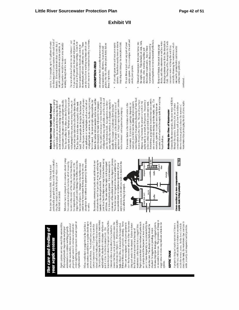
Little River Sourcewater Protection Plan Page 42 of 51
Exhibit VII

Little River Sourcewater Protection Plan Page 43 of 51
Exhibit VII (Cont’d)

Little River Sourcewater Protection Plan Page 44 of 51
Exhibit VIII

Little River Sourcewater Protection Plan Page 45 of 51
Exhibit VIII (Cont’d)

Little River Sourcewater Protection Plan Page 46 of 51
Exhibit VIII (Cont’d)

Little River Sourcewater Protection Plan Page 47 of 51
Exhibit VIII (Cont’d)

Little River Sourcewater Protection Plan Page 48 of 51
Exhibit VIII (Cont’d)

Little River Sourcewater Protection Plan Page 49 of 51
Exhibit VIII (Cont’d)

Little River Sourcewater Protection Plan Page 50 of 51
Exhibit VIII (Cont’d)

Little River Sourcewater Protection Plan Page 51 of 51
Exhibit VIII (Cont’d)