
SOP17 - Water Chemistry Field Data and Sample … · Web viewArctic Network National Parks and...
35
Stream and Lake Monitoring Protocol SOP 09 – Water Chemistry Field Data and Sample Collection, v. 1.0, Page 1 of 35 Stream and Lake Monitoring Protocol Arctic Network National Parks and Preserves, Alaska Standard Operating Procedure (SOP) #09 Stream Water Chemistry Field Data and Sample Collection Version 1.0 (streams) (November 2007) I Revision History Log: Prev. Versio n # Revision Date Author Changes Made Reason for Change New Version # II Introduction This SOP provides step-by-step instructions for collecting physical habitat conditions, water quality data and water samples, and biological community samples that will be analyzed by the laboratory for the five National Park units in the Arctic Network (ARCN). This procedure is carried out after the stream is located and before any biotic sampling has commenced. This SOP describes how to collect and record conventional water quality parameters and how to collect, filter and label the water chemistry samples and fill out the Stream Characterization (Figure 5) and Water Quality data form (Figure 6) when at the Arctic Network November, 2007
Transcript of SOP17 - Water Chemistry Field Data and Sample … · Web viewArctic Network National Parks and...

Stream and Lake Monitoring ProtocolSOP 09 – Water Chemistry Field Data and Sample Collection, v. 1.0, Page 1 of 24
Stream and Lake Monitoring ProtocolArctic Network National Parks and Preserves, Alaska
Standard Operating Procedure (SOP) #09Stream Water Chemistry Field Data and Sample Collection
Version 1.0 (streams) (November 2007)
I Revision History Log:
Prev. Version #
Revision Date
Author Changes Made Reason for Change New Version #
II Introduction
This SOP provides step-by-step instructions for collecting physical habitat conditions, water quality data and water samples, and biological community samples that will be analyzed by the laboratory for the five National Park units in the Arctic Network (ARCN). This procedure is carried out after the stream is located and before any biotic sampling has commenced.
This SOP describes how to collect and record conventional water quality parameters and how to collect, filter and label the water chemistry samples and fill out the Stream Characterization (Figure 5) and Water Quality data form (Figure 6) when at the stream sampling site. SOP 11 describes procedures to titrate, analyze, and preserve samples at the end of the day.
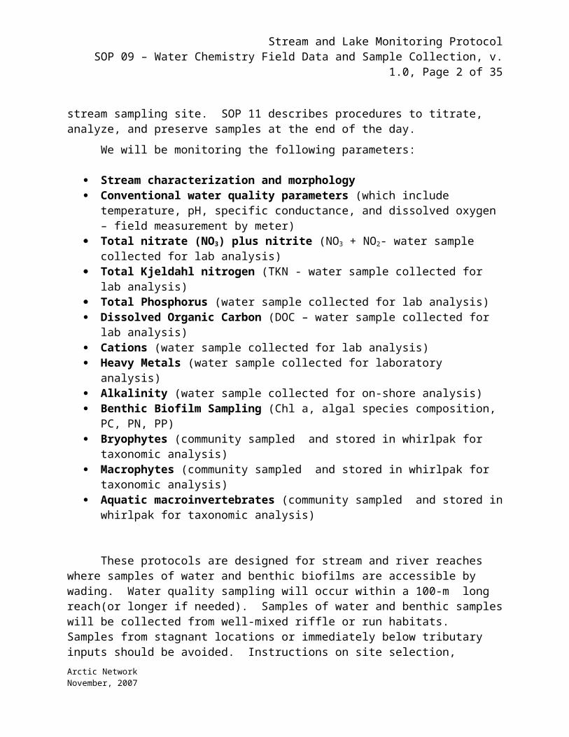
We will be monitoring the following parameters:
Stream characterization and morphology Conventional water quality parameters (which include temperature, pH, specific
conductance, and dissolved oxygen – field measurement by meter) Total nitrate (NO3) plus nitrite (NO3 + NO2- water sample collected for lab analysis) Total Kjeldahl nitrogen (TKN - water sample collected for lab analysis) Total Phosphorus (water sample collected for lab analysis) Dissolved Organic Carbon (DOC – water sample collected for lab analysis) Cations (water sample collected for lab analysis)
Arctic NetworkNovember, 2007
Stream and Lake Monitoring ProtocolSOP 09 – Water Chemistry Field Data and Sample Collection, v. 1.0, Page 2 of 24
Heavy Metals (water sample collected for laboratory analysis) Alkalinity (water sample collected for on-shore analysis) Benthic Biofilm Sampling (Chl a, algal species composition, PC, PN, PP) Bryophytes (community sampled and stored in whirlpak for taxonomic analysis) Macrophytes (community sampled and stored in whirlpak for taxonomic analysis) Aquatic macroinvertebrates (community sampled and stored in whirlpak for
taxonomic analysis)
These protocols are designed for stream and river reaches where samples of water and benthic biofilms are accessible by wading. Water quality sampling will occur within a 100-m long reach(or longer if needed). Samples of water and benthic samples will be collected from well-mixed riffle or run habitats. Samples from stagnant locations or immediately below tributary inputs should be avoided. Instructions on site selection, establishing GPS location, physical habitat metrics, reach surveys and photo documentation are covered in other protocols.
Sampling should ideally occur under typical summer flow conditions when water and benthic samples are readily accessible from stream areas that are typically submerged. Sampling at extreme high flow conditions will of course result in unusual chemical composition and the normally wetted benthic habitat may be inaccessible. Sampling under these conditions can be dangerous. Under all sampling conditions at least 2 persons must be present for safety.
III Stream Side Procedures
1. Unpack equipment and sample bottles from the Action Packers (or other field packs). If sample bottles are not prelabeled, label all sample containers and bottles with the following information: “sample parameter-siteID-date&time-sampler initials.”
2. Assemble the survey and field note equipment: PDA or field recording sheets, radio, compass, rangefinder
3. Assemble the in-situ water monitoring equipment: WTW meter (or other suitable instrument such as a Hydrolab) for temperature, pH, electrical conductivity and dissolved oxygen.
4. Perform a calibration of the WTW (see manual for detailed instructions).
Approximately 20 minutes is required to set up the instrument and check the instrument calibration before and after sample testing. Generally, 5 minutes is sufficient for an experienced analyst to complete the analysis of conventional parameters in the field.
Caution: Meter power should not be turned on when the pH electrode is dry. The electrode may become polarized and permanently damaged. pH electrodes should be wetted with or stored in pH 7.0 buffer. Storage in deionized water will permanently damage the electrode. Dissolved oxygen electrodes should be stored in water or water saturated air (i.e., water soaked tissue, water in protective sleeve, etc.)
Arctic NetworkNovember, 2007

Stream and Lake Monitoring ProtocolSOP 09 – Water Chemistry Field Data and Sample Collection, v. 1.0, Page 3 of 24
Perform a single point calibration check using the CalCheck (pH 7.0 buffer and a mid-range [100 to 500 S/cm] specific conductance) standard solution.
Perform a calibration check of DO % saturation using the following saturated-air method (see WTW user manual for reference):
- Fill the Calibration Cup with deionized or tap water (specific conductance less than 0.5 mS/cm) until the water is just level with the o-ring used to secure the membrane.- Carefully remove any water droplets from the membrane with the corner of a tissue.- Turn the black calibration cup cover upside down (concave upward) and lay it over the top of the Calibration Cup.- Determine the barometric pressure for entry as the calibration standard. Computation details on barometric pressure are given below:
- Local barometric pressure, BP, in mmHg can be estimated using:
1. BP = 760- 2.5(Aft/100) or BP = 760- 2.5(Am/30.5),
where ‘Aft’ is the local altitude above sea level in feet and ‘Am’ is the local altitude above sea
level in meters.
- If using the local weather bureau BP, remember these numbers are corrected to
sea level. To
i. calculate the uncorrected atmospheric pressure BP', use one of the
following functions:
1. BP' = BP-2.5(Aft /100) or BP' = BP-2.5(Am /30.5)
- Local barometric pressure in mbar (BPmbar) can be converted to local barometric
pressure in
i. mmHg (BPmmHg) using:
1. BPmmHg = 0.75 x BPmbar
Note that Calibration of DO %Saturation also calibrates DO mg/L.
5. Record GPS coordinates.
IV Physical Characteristics – Lotic Habitats
Both physical characteristics and water quality chemical parameters are pertinent to characterization of the aquatic habitat. An example of the data sheet used to characterize the
Arctic NetworkNovember, 2007

Stream and Lake Monitoring ProtocolSOP 09 – Water Chemistry Field Data and Sample Collection, v. 1.0, Page 4 of 24
physical characteristics and water quality of a lotic site is shown in SOP 01. The following physical characteristics should be recorded on the field sheet from Lotic and Lentic Habitats:
1. Header Information – The header information is identical on all data sheets and requires sufficient information to identify the station and location where the survey was conducted, date and time of survey, and the investigators.
2. Weather Conditions – Note the present weather conditions on the day of the survey and those immediately proceeding the day of the survey. This information is important to interpret the effects of storm events on the sampling effort.
3. Site Location/Map – A photograph may be helpful in identifying station location and documenting habitat conditions. A hand drawn map is useful to illustrate major landmarks or features of the channel morphology, vegetation zones, buildings etc. that might be used to aid in data interpretation. GPS units can be used to obtain latitude and longitude coordinates.
4. Watershed Featuresa) Describe predominant surrounding land use typeb) Note local watershed nonpoint source pollutionc) Note if stream is channelized, or if there is an upstream damd) Note if the water level is regulated
5. Riparian Vegetation – An acceptable riparian zone includes a buffer strip of a minimum of 50 feet from the stream on either side, and a minimum of 100 feet from the lake shore. The width of the riparian zone and the vegetation within the riparian zone should be documented.
6. Estimate Water Depth – Estimate the vertical distance from the water surface to the bottom at a representative depth to obtain an average depth.
7. Velocity (Lotic only) – Measure the bottom velocity at the points in the stream where macroinvertebrate samples are taken. Use a calibrated velocity meter and record type of meter used. If a direct measurement is not done, estimate the velocity within the sampling reach as slow (<0.4ft/sec), moderate (0.4-2 ft/sec) or fast (>2ft/sec).
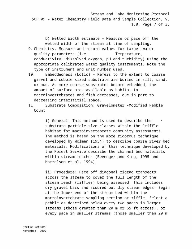
8. Stream Width (Lotic)a) Bankfull Width estimate Channel width at bankfull discharge. Measure or pace off the distance from bank to bank at a transect representative of the average stream width in the reach.b) Wetted Width estimate – Measure or pace off the wetted width of the stream at time of sampling.
9. Chemistry. Measure and record values for target water quality parameters (i.e. Temperature, conductivity, dissolved oxygen, pH and turbidity) using the appropriate calibrated water quality instruments. Note the type of instrument and unit number used.
10. Embeddedness (Lotic) – Refers to the extent to coarse gravel and cobble sized substrate are buried in silt, sand, or mud. As more coarse substrates become embedded, the amount of surface area available as habitat to macroinvertebrates and fish decreases, due in part to decreasing interstitial space.
11. Substrate Composition: Gravelometer -Modified Pebble Count
Arctic NetworkNovember, 2007

Stream and Lake Monitoring ProtocolSOP 09 – Water Chemistry Field Data and Sample Collection, v. 1.0, Page 5 of 24
i) General: This method is used to describe the substrate particle size classes within the “riffle” habitat for macroinvertebrate community assessments. The method is based on the more rigorous technique developed by Wolmen (1954) to describe coarse river bed materials. Modifications of this technique developed by the Forest Service describe the channel bed materials within stream reaches (Bevenger and King, 1995 and Harrelson et al, 1994).
ii) Procedure: Pace off diagonal zigzag transects across the stream to cover the full length of the stream reach (riffles) being assessed. This includes dry gravel bars and scoured but dry stream edges. Begin at the lower end of the stream bed within the macroinvertebrate sampling section or riffle. Select a pebble as described below every two paces in larger streams (those greater than 20 m or 65 ft across), or every pace in smaller streams (those smaller than 20 m or 65 ft across). Examine a minimum of 100 particles over the course of the reach.
iii) Avert the eyes away from the streambed to reduce visual bias on substrate selected. Extend an index finger until it touches the first piece of substrate encountered in the streambed. Place the substrate in the gravelometer to determine particle size category. Size categories were initially based on the Wentworth's size classes.
iv) Size categories are determined by using a gravelometer. This is essentially a metal plate with square openings ranging from 4 mm to 128 mm while notches on the top edge measure 180, 256 and 362 mm. Bottom notches provide additional measurements. The particle must be placed through the smallest opening so that the intermediate axis is perpendicular to the sides (not diagonally across) of the opening. The smallest size category that the particle falls through is called out to a recorder, who keeps track of the tally until the minimum of 100 particles is reached. Complete the transect if this occurs in the middle of the stream.
12. Stream reach characterization (Methods in stream ecology Chapter 2).
i) General: This method is used to describe the general characteristics of the stream reach with respect to valley location. Key characteristics may provide evidence of disturbance or direction of change and condition of the stream.
ii) Procedure: refer to the stream characterization data sheet. The observer should record conditions of both true left and true right (facing downstream). Starting at either end of the reach, divide the reach into atleast 10 equally spaced sections. Record condition along the reach at the start of each segment.
First record the type of stream throughout the reach: cascade, step-pool, plane-bed, riffle-pool, ripple-dune, or braided. Record the major morphological characteristic of chute, fall, cascade, run, pool, riffle, or step. For each bank determine if the bank is eroding and record. Determine the major substrate along each side of the stream; boulder, cobble, gravel, ledge, muck, peat, or
Arctic NetworkNovember, 2007

Stream and Lake Monitoring ProtocolSOP 09 – Water Chemistry Field Data and Sample Collection, v. 1.0, Page 6 of 24
sand. Lastly, determine what the major benthic vegetation along each segment and record using the keys: epilithon, filament, leafy, moss, or sedge. Record any comments for each reach that may influence other stream chemistry or community samples. After walking the reach, characterize the true right and true left corridor by noting topography and floodplain characteristics.
Conventional Parameters Data Collection
1. Place the WTW probes in flowing stream water.2. Wait until parameters stabilize and record results in the “ConvenWQ 1” row on the Water
Quality Field Form page of the PDA. Results for pH should be reported to 0.1 pH unit; specific conductance to two significant figures; temperature to the nearest 0.1o C; and dissolved oxygen to the nearest 0.1 mg/L. Record specific conductance.
3. Repeat step 2 three more times (3 total replicate measurements).4. Transmit (voice or radio the results to the scribe on shore for backup recording onto the
paper version of the water quality field form.5. Calculate the mean and standard deviations of the water quality parameter measurements.
If the standard deviation is greater than 10 percent of the mean for any one parameter, recalibrate the WTW for that parameter and re-collect the data (all three samples). If the standard deviation is still too high, note that in the Notes column. These data will be flagged in the database. Attempt to identify any legitimate causes for the high variability in the stream and note those possibilities for future reference.
6. Retrieve probe and rinse with deionized water.
V Streamside Chemistry Sample Collection and Processing
Water Chemistry Sampling Supplies ( Also at back of chapter ) Nitrate – 60 ml HDPE bottleTDN - 60 ml HDPE bottle TDP - 60 ml HDPE bottle DOC – 60 ml HDPE Cations - 60 ml HDPE bottle Heavy Metals – 125 ml HDPE bottle – supplied by Severn Trent
Laboratories (bottleshave 2.5 mls of nitric acid inside of them)60-cc syringes Syringe filters (0.45 micron) and filter holders or pre-made syringe filter
capsules Sharpie and label tapeCoolerIce packs or dry ice
Arctic NetworkNovember, 2007
Stream and Lake Monitoring ProtocolSOP 09 – Water Chemistry Field Data and Sample Collection, v. 1.0, Page 7 of 24
Physical preservation techniques are used for all samples and include cooling and keeping the samples out of the sunlight. Some of the water samples are also preserved with acid to prevent degradation of constituents before they are analyzed.
1. At each site, go to the center of the stream and rinse the 60cc syringe 3x with stream water. Fill the syringe with stream water, mount a new, sterile syringe filter onto the syringe and rinse the filter with 50 ml of stream water.
2. Rinse each sample bottle 3x with a few ml of filtered stream water.
3. Refill the syringe as necessary and push 50 ml of water into the respective labeled sample bottles: NO3, TDN, TDP, DOC, cations and 100 ml of water for heavy metals – 350 mls total.
4. Avoid making any physical contact with the filtered water. Your skin can contaminate the water for certain analyses. Keep mosquitoes and unfiltered stream water out of the sample bottles.
5. Make certain every bottle has a date and stream site and that label is secured.
6. Mark liquid level on bottles using Sharpie.
7. Place samples in a large Ziploc bag and place into cooler at or below 4C. If ice is not available, store the samples in a cool, dark container and keep samples organized by stream site.
8. Record sample IDs onto water quality field form.
At end of day begin processing by following the preservation, titration, and analysis processes outlined in SOP 21. Samples should be analyzed as soon as possible after collection but can be stored at least 24 hours by cooling to 4 °C (39 °F) or below. If stored, warm the sample to room (or at least ambient) temperature before analyzing.
For SOP 21.(Post Collection at Camp: Acidifying and storing
a. Acidify the TDN, TDP, cations and heavy metals with 100 microliters of 6N HCl for every 50 mls of sample. **NOTE: NO3 samples are not acidified!! Store in a cool, dark place.)
b. Also at camp, samples will be titrated for alkalinity and analyzed for chlorophyll)
VI Streamside Benthic Sampling for epilithic Chlorophyll (Chla), Algal Species Composition, epilithic total particulate carbon (TPC), total particulate nitrogen (TPN), and total particulate phosphorus (TPP).
Benthic Biofilm SamplesWash basin for rock scrubs
Arctic NetworkNovember, 2007

Stream and Lake Monitoring ProtocolSOP 09 – Water Chemistry Field Data and Sample Collection, v. 1.0, Page 8 of 24
2x2 slide holderSmall steel bristle scrub brush125-ml squeeze bottle(6) 25mm ashed GF/F filters(6) Petri dishes for ashed 25mm GF/F filters *Complete (2) different
composites of 5 rocks each.- TPC/TPN (2 filters)- TPP (2 filters)- Chla (2 filters)
Filtering unit:- Filter tower- Filter flask- Filter tower clamp- Vacuum hand pump
SharpiePlastic Graduated Cylinder- 500 mlPlastic Funnel Forceps1 60-ml HDPE bottle for algal slurryLugol’s Algal Preservative Solution
This sampling protocol assumes the stream has a rocky cobble bottom. If possible, rocks for epilithic biofilm sampling should be collected from riffles (or runs if riffles are absent) because rocks from pools may have accumulations of fine sediments that smothers the biofilm community and makes it difficult to sample without disturbance.
a. At each station, rinse the wash basin, scrub brush, slide holders, and wash bottle 3X with river water. Fill the wash bottle with river water.
b. From each of three riffles, select 2 rocks (for 6 rocks total at each stream reach) that fit the following criteria:(1) rocks with no filamentous algae or moss (to eliminate
overestimates of algal chl due to filamentous algae or moss)
(2) rocks with fairly smooth upper surface (uneven surfaces prevent efficient removal of epilithon)
(3) rocks that have been submerged for a long period of time.
It is possible that very few rocks at some sites will meet all of the above criteria. If you must select rocks that do not fit any or all of the criteria, make careful and thorough notes describing the deviations.
c. Place the slide holder over a smooth portion of the upper surface of the rock. With the brush, scrub the area within slide holder. Hold the rock over the basin so that all scrubbate falls into the basin.
Arctic NetworkNovember, 2007

Stream and Lake Monitoring ProtocolSOP 09 – Water Chemistry Field Data and Sample Collection, v. 1.0, Page 9 of 24
d. With the 125-ml wash bottle, rinse the scrubbed area, the holder, and the brush into the basin. Pour any remaining rinse water into the basin. 260 mls of slurry are required for filtering and the algal sample – rinse the total number of rocks with 375 mls of stream water (empty the 125-ml bottle 3 times).
e. Pour the contents of the basin into graduated cylinder. Use the funnel to facilitate pouring.
f. There should be ~ 375 mls of slurry in the graduate cylinder.
g. Set up filtering apparatus. Filter the following amounts of slurry through the 25mm ashed GF/F filters (Record volumes passing through each filter!)
For the two composites (12 rocks total are scrubbed, 6 in each composite – keep the two 375 ml slurries separate as replicate samples.
CHLa – pass 10 mls onto each filter (perhaps more if filter is not loaded enough)( take 2 samples, one from each slurry)
TPC/TPN + isotopes – pass 100 mls onto each filter (2)
TPP – pass 100 mls (check on this) onto each filter (2)
Blank – pass 100 mls of stream water through filter (or max volume passed through).
Algal counts – Collect ~ 40-50mls of slurry in HDPE bottle and add a few drops of Lugol’s solution.
h. Using forceps, place each filter into its own labeled petri dish. Fold each filter and place inside a folded foil cover.
i. Clean the filtration devices thoroughly after completing filtrations of all samples for each stream.
j. Collect any visible macroalgae, aquatic macrophytes and bryophytes and store in Whirlpaks bags or paper bags.
Post Collection at Camp:
k. Allow filters for TPC/TPN + isotopes and TPP in petri dishes to dry as much as possible. (If a freezer or dry ice is available, filters may be held frozen for subsequent drying at the laboratory.)
l. Perform Chla extractions: Using forceps, place each of the Chla filters into 10mls of 100% acetone in a 15-ml centrifuge tubes. Make sure filter is completely immersed in acetone, cap tightly and place in light tight box for extraction. These filters will be analyzed for Chlorophyll a content after a 16-
Arctic NetworkNovember, 2007

Stream and Lake Monitoring ProtocolSOP 09 – Water Chemistry Field Data and Sample Collection, v. 1.0, Page 10 of 24
18 hour extraction period. Tubes should be inverted/mixed at least once during extraction, but allow sufficient time (>4hours) for particles to settle before reading.
m. See SOP11 protocol for Chla analysis
iii)
VII Macroinvertebrate sampling-qualitative
These methods explain the procedure for aquatic invertebrate sample collection within wadable streams in the Arctic Network National Parks and Preserves. These methods have been modified from Barbour et al. 1999. Macroinvertebrate sampling should be conducted after water chemistry sampling (Water chemistry Field Data and Sampling Collection). The basic approach involves sampling invertebrates within the designated stream reach with a standard D-frame multihabitat dip-net fitted with 500-µm mesh. Ideally one person will collect all invertebrate samples in a season to reduce inter-observer effects. If this is not possible, at least ensure that one person collects all invertebrate samples for a single stream.
VIII Procedure
Establish sampling points
1. A 100 m reach representative of the characteristics of the stream should be selected. Whenever possible, the area should be at least 100 meters upstream from any road or bridge crossing to minimize its effect on stream velocity, depth, and overall habitat quality. There should be no major tributaries discharging to the stream in the study area.
2. Before sampling, complete the physical/chemical field sheet (see SOP 01) to document site description, weather conditions, and land use. After sampling, review this information for accuracy and completeness.
3. Draw a map of the sampling reach. This map should include in-stream attributes (e.g., riffles, falls, fallen trees, pools, bends, etc.) and important structures, plants, and attributes of the bank and near stream areas. Use an arrow to indicate the direction of flow. Indicate the areas that were sampled for macroinvertebrates on the map. Estimate “river mile” for sampling reach for probable use in data management of the water resource agency. If available, use hand-held Global Positioning System (GPS) for latitude and longitude determination taken at the furthest downstream point of the sampling reach.DRAFT REVISION—September 24, 1998
Arctic NetworkNovember, 2007

Stream and Lake Monitoring ProtocolSOP 09 – Water Chemistry Field Data and Sample Collection, v. 1.0, Page 11 of 24
4. All riffle and run areas within the 100-m reach are candidates for sampling macroinvertebrates. A composite sample is taken from individual sampling spots in the riffles and runs representing different velocities. Generally, a minimum of 2 m2
composited area is sampled for RBP efforts.
5. Sampling begins at the downstream end of the reach and proceeds upstream. Using a standard D-frame multihabitat dip-net with 500-µm mesh position the net on the substrate and disturb the area just upstream (~0.5-1m) and allow the flow to carry benthos into the net. This can be standardized by timing the total active time kicking or can be standardized by disturbing similar area across each stream.
6. After every sample, wash the collected material by running clean stream water through the net 2 to 3 times. Remove large debris after rinsing and inspecting it for organisms; place any organisms found into the sample container. Do not spend time inspecting small debris in the field.
7. If the sample is large or gravel and sand have entered the net portion, alutriate the sample in the field. All material from the net should be washed into a 20-L bucket and clean stream water should be used to separate all organic and lighter material from the inorganic substrate. A swirling motion and agitation of sample in bucket should remove benthos and organic matter. Repeat until water remains clear after agitation and pour through 0.25 m mesh sieve. Inspect remaining inorganics for heavy organisms (mussels, Trichoptera with case).
8. Transfer the sample from the sieve to sample container(s) and preserve in enough 95 percent ethanol to cover the sample. Forceps may be needed to remove organisms from the dip net. Place a label indicating the sample identification code or lot number, date, stream name, sampling location, and collector name into the sample container. The outside of the container should include the same information and the words “preservative: 95% ethanol”. If more than one container is needed for a sample, each container label should contain all the information for the sample and should be numbered (e.g., 1 of 2, 2 of 2, etc.). This information will be recorded in the "Sample Log" at the biological laboratory.
10. Record the percentage of each habitat type in the reach. Note the sampling gear used, and comment on conditions of the sampling, e.g., high flows, treacherous rocks, difficult access to stream, or anything that would indicate adverse sampling conditions.DRAFT REVISION—September 24, 1998
Sample Processing
1. Use a white plastic tray/tub to collect the sample as it is dumped and rinsed (using lake water in a Nalgene squirt bottle) from the collecting net. Remove any pieces of large debris after rinsing and inspecting them for organisms; place any organisms found into sample container.
2. Use a brass soil sieve or sieve bucket with a mesh size equal to that of the D-net (500 m; No. 30 mesh) to drain water from the samples before preserving.
3. Rinse the samples into Nalgene collection bottles using ethyl alcohol in a Nalgene squirt bottle (at 95% strength) and a wide orifice funnel. Forceps may be needed to remove organisms from the dip net or the sieve. Add additional alcohol to sample container to insure a minimum of 80% ethanol concentration after dilution from water in the sample.
Arctic NetworkNovember, 2007

Stream and Lake Monitoring ProtocolSOP 09 – Water Chemistry Field Data and Sample Collection, v. 1.0, Page 12 of 24
4. Use Rite-in-the-Rain paper and a pencil to enter sample data on pre-prepared label; enclose label in the sample. As a backup, attach label written with an alcohol-proof pen to the Nalgene bottle.
5. Include on both sample labels at least the following minimal information: location, date, names/initials of collectors. Location information should include name of stream and sample point along the transect. Also note the dominant habitat and dominant vegetation for each sample (see example on field data sheet).
6. Record observational data on insects that are hatching during the sampling session, as well as any adult aquatic insects that have hatched
7. Assure that lids are securely tightened and store sample bottles in a safe place where they are not likely to be disturbed or damaged.
8. Record also observations of birds feeding on the water (e.g., phalaropes, terns, grebes) and any fish seen in the water.
9. Check and cross-check all data entry on field forms and field data recorder.
10. Enter field tracking information on the macroinvertebrate sample tracking form and in the PDA
IX Quality Control
Labeling. Assure that sample labels are complete and placed both inside and outside the sample container and are written with the proper writing utensil.
Equipment. Rinse all nets, pans, sieves, etc. that came into contact with the sample after completion of each sampling station. Examine equipment carefully and remove any remaining organisms or debris. Any additional organisms should be placed into the appropriate sample container.
Sample Collection. Methods used to collect samples should be the same at every site.
QUALITY CONTROL (QC) IN THE FIELD1. Sample labels must be properly completed, including the sample identification code, date, stream name, sampling location, and collector’s name, and placed into the sample container. The outside of the container should be labeled with the same information. Chain-of-custody forms, if needed, must include the same information as the sample container labels.2. After sampling has been completed at a given site, all nets, pans, etc. that have come in contact with the sample should be rinsed thoroughly, examined carefully, and picked free of organisms or debris. Any additional organisms found should be placed into the sample containers. The equipment should be examined again prior to use at the next sampling site.3. Replicate (1 duplicate sample) 10% of the sites to evaluate precision or repeatability of the sampling technique or the collection team.
Arctic NetworkNovember, 2007

Stream and Lake Monitoring ProtocolSOP 09 – Water Chemistry Field Data and Sample Collection, v. 1.0, Page 13 of 24
FIELD EQUIPMENT/SUPPLIES NEEDED FOR BENTHICMACROINVERTEBRATE SAMPLING—MULTI-HABITAT APPROACH• standard surber sampler, 0.25 m opening mesh, 0.3 m width x 0.3 m height(0.9 m ft frame width)• 20 L bucket 0.25 m mesh standard sieve• 95% ethanol• sample containers, sample container labels• forceps• pencils, clipboard• Benthic Macroinvertebrate Field Data Sheet*• first aid kit• waders (chest-high or hip boots)• rubber gloves (arm-length)• camera• Global Positioning System (GPS) Unit* It is helpful to copy fieldsheets onto water-resistant paper for usein wet weather conditions
X Macroinvertebrate Sampling-quantitative
General Macroinvertebrate Sampling Protocol (Surber/Biomass)
A Surber sampler (243-μm mesh) will be used to collect quantitative macroinvertebrate samples. Five samples will be taken from at least two separate riffles in each stream. Substrate will be scrubbed with a brush to dislodge macrophytes and detritus. Samples will be preserved in 95% ethanol. Laboratory processing will consist of the following steps. Invertebrates will be removed by hand under magnification. Invertebrates will be identified to the lowest practical taxonomic level, usually genus, and assigned to functional-feeding groups. Biomass will be estimated from measurements of body length using family-level length-mass relationships. Density and biomass/m2 for each taxon present will be estimated from each stream. Macrophytes obtained during sampling will be oven dried for 48 hr at 60 oC. Dry mass will be measured and then the sample will be ignited in a muffle furnace (500 oC). The remaining ash mass will be measured and subtracted from dry mass to estimate ash-free dry mass.
Macroinvertebrate Sampling protocol
1. Sample in net - Using a 0.3 m x 0.3 m surber net, 5 samples are taken at various velocities in the riffle or series of riffles. A sample is a stationary sampling accomplished by positioning the net and disturbing the area in the quantitative frame up stream of the cod end. Using hands or the end of a scrub brush, dislodge the upper layer of cobble or
Arctic NetworkNovember, 2007

Stream and Lake Monitoring ProtocolSOP 09 – Water Chemistry Field Data and Sample Collection, v. 1.0, Page 14 of 24
gravel and scrape the underlying bed. Larger substrate particles should be picked up and rubbed by scrub brush to remove attached organisms. Five surber samples should be selected from at least two separate riffles in each stream. If possible, vary location within riffles (some below riffle some above some within). The surber sample frame should be placed on stream substrate so that opening of collection net is perpendicular to water flow. For optimum effectiveness, flow should be great enough to carry dislodged benthos into sample net but flow should not be so great that bow wave forms in front of net. Substrate should be disturbed within sample frame to a depth of ~10 cm. All cobble (any substrate larger than what fits in your mouth) should be scrubbed with a brush to dislodge macrophytes, macroinverts, and detritus. For consistency, any cobble/boulder that is within the sample frame greater than 50% should be included in the sample.
2. Sample in bucket - Once sample is contained within the surber net, contents can be rinsed (with stream water) down to the bottom of the net for ease of transfer to 3 gallon (11.4 L) bucket for elutriation. Sample should be transferred from net to bucket with aid of squirt bottle. Inspect net for any stubborn macroinverts or macrophytes. Add a couple liters of clean stream water to bucket and disturb sample in a spinning motion. Slowly pour contents of bucket through a 250 μm sieve leaving behind rocks and sand. Repeat process of elutriation until no organic material remains in bucket.
3. Sample in sieve - Once sample has been transferred to sieve, use squirt bottle to transfer to whirl pack. Examine sieve for stubborn macroinverts or macrophytes.
4. Sample in whirl pack - Once sample is in whirl pack, 5 mls (10 mls if sample is large) of formaldehyde should be added to sample. Add a label (pencil on plastic paper only) inside the whirl pack containing pertinent sample info including Site, Date, sample location within reach as downstream length in meters, surber sample #/5, initials of sample teamExample:
Fen123b13-Jul-06, 20 mSurber 2/5, MF KR
Seal up whirl pack and add Site, date, and surber # of 5 with sharpie on outside of whirl pack.
Materials:Surber sampler3 gallon bucketsquirt bottlesnylon dishwashing brushes 250 um sieveFormalin -- 40% when you order it, it becomes 4% after you add it tothe sample, you should probably add about 10 ml to a regular sample,20 ml if it's huge and mossy
Arctic NetworkNovember, 2007

Stream and Lake Monitoring ProtocolSOP 09 – Water Chemistry Field Data and Sample Collection, v. 1.0, Page 15 of 24
whirl pakswaterproof labelsscint vials
XI Decontamination
Instrument Cleaning and Storage -13. Be sure there are no bits of vegetation or sediment on WTW and other gear prior to
leaving the stream.14. If electrodes are fouled or dirty, gently clean with a moist tissue or a soft brush. 15. During storage or transport, always use the calibration cup/cap or the storage cup filled
with a 1/4” of tap water to protect the sensors from damage and drying out.
Other Equipment Cleaning-
When finished filling sample bottles, rinse syringes and any other equipment not yet cleaned with deionized water from jug to prevent cross-contamination between streams.
XII Quality Control
Data Completeness
Before leaving the field site, data sheets must be checked for completeness and readability. Data sheets will be checked by a different field crew member than the one who filled it out. That person marks each page “checked”, with their initials and the date.
Conventional Water Quality Parameters
1. Perform one calibration check analysis for pH, DO, and specific conductance using standard solutions prior to sampling at each stream.
2. Perform three replicate measurements. The standard deviation of the three measurements must be less than 10 percent of the mean. If the calculations of standard deviation are made in the field and show high variability, the WTW should be recalibrated and the measurements retaken. If these parameters are not calculated in the field and the standard deviation is discovered to be not within 10 percent, or the sample results are still out of specification after recalibrating the instrument, the data are flagged as “Highly Variable” in the database. Inspection may show that one measurement was far out of alignment from the others, in which case it may be possible to justify discarding that data point as an outlier. Such a decision is made by the Project Manager during data analysis.
Chemistry Grab Samples – duplicates at designated sites.
a. Collect field duplicates in the course of repeat-sampling the duplicate streams.
Arctic NetworkNovember, 2007

Stream and Lake Monitoring ProtocolSOP 09 – Water Chemistry Field Data and Sample Collection, v. 1.0, Page 16 of 24
b. Once on each field trip, fill one set of lab sample bottles with deionized water as field blanks. Label them with a phony lake name and afix sample labels to the bottles. Enter the sample IDs on a field form set up for the phony lake; note that the lake is a blank on the field form.
XIII Equipment
General
waders
2-way radio
Polarized sunglasses
Copy of SOPs 15, 17 and 21 (for reference)
Copy of WTW user manual
PDA
Field forms
Sample labels
Sharpie pens
Compass
Rangefinder
GPS
Extra line
Tape measure
Deionized water
Kimwipes
Rubbing alcohol or methanol
Conventional Parameters
WTW
Hydrolab calibration check standards
pH 7.0 buffer for storage of Hydrolab pH sensor
calculator
Water Chemistry SamplesNitrate – 60 ml HDPE bottle
Arctic NetworkNovember, 2007

Stream and Lake Monitoring ProtocolSOP 09 – Water Chemistry Field Data and Sample Collection, v. 1.0, Page 17 of 24
TDN - 60 ml HDPE bottle TDP - 60 ml HDPE bottle DOC – 60 ml HDPE Cations - 60 ml HDPE bottle Heavy Metals – 125 ml HDPE bottle – supplied by Severn Trent
Laboratories (bottleshave 2.5 mls of nitric acid inside of them)60-cc syringes Syringe filters (0.45 micron) and filter holders or pre-made syringe filter
capsules Sharpie and label tape
Cooler
Ice packs or dry ice
Benthic Biofilm SamplesWash basin for rock scrubs2x2 slide holderSmall steel bristle scrub brush125-ml squeeze bottle(6) 25mm ashed GF/F filters(6) Petri dishes for ashed 25mm GF/F filters *Complete (2) different
composites of 5 rocks each.- TPC/TPN (2 filters)- TPP (2 filters)- CHLa (2 filters)
Filtering unit:- Filter Tower- Filter Flask- Vacuum hand pump
Plastic graduated cylinder- 500 mlPlastic funnel (optional)SharpieForceps1 60-ml HDPE bottle for algal slurryLugol’s
Macroinvertebrate samples – qualitative
standard surber sampler, 0.25 m opening mesh, 0.3 m width x 0.3 m height(0.9 m ft frame width) 20 L bucket0.25 m mesh standard sieve 95% ethanol sample containers, sample container labels forceps
Arctic NetworkNovember, 2007

Stream and Lake Monitoring ProtocolSOP 09 – Water Chemistry Field Data and Sample Collection, v. 1.0, Page 18 of 24
pencils, clipboard Benthic Macroinvertebrate Field Data Sheet* first aid kit waders (chest-high or hip boots) rubber gloves (arm-length) camera Global Positioning System (GPS) Unit*It is helpful to copy fieldsheets onto water-resistant paper for use
in wet weather conditions
Macroinvertebrate samples – quantitative
Surber sampler3 gallon bucketsquirt bottlesnylon dishwashing brushes 250 um sieveFormalin -- 40% when you order it, it becomes 4% after you add it tothe sample, you should probably add about 10 ml to a regular sample,20 ml if it's huge and mossywhirl pakswaterproof labelsscint vials
XIV References
Bevenger, G.S., and R.M. King. 1995. A pebble count procedure for assessing watershed cumulative effects. USDA Forest Service Research Paper RM-RP-319, Rocky Mountain Forest and Range Experiment Station, Fort Collins, Colorado.
Bisson, Peter A.; Montgomery, David R.; Buffington, John M. 2006. Valley segments, stream reaches, and channel units In: Hauer, F. R.; Lamberti, G. A., eds. Methods in Stream Ecology. Second Edition. San Diego, CA: Academic Press. p. 23-49.
Cummins, K.W. and R.W. Merritt. 1996. Ecology and distribution of aquatic insects. In R.W. Merritt and K.W. Cummins, eds. An introduction to the aquatic insects of North America. 3rd ed. Kendall/Hunt Publishing Co., Dubuque, Iowa.
EPA Method 415.1. Methods for Chemical Analysis of Water and Wastes.
Arctic NetworkNovember, 2007

Stream and Lake Monitoring ProtocolSOP 09 – Water Chemistry Field Data and Sample Collection, v. 1.0, Page 19 of 24
Harrelson, C.C., C.L. Rawlins, and J.P. Potyondy. 1994. Stream channel reference sites: an illustrated guide to field technique. USDA Forest Service General Technical Report RM-245-Harrelson, et al (1994).Oswood, M., T. Simpson, L. Saperstein, and S. Nelson. 2001. The freshwater benthos of the Kanuti National Wildlife Refuge. Kanuti National Wildlife Refuge Final Report FY01-01.
Standard Methods for the Examination of Water and Wastewater (APHA), Method 4500-N.
Standard Methods for the Examination of Water and Wastewater (APHA), Method 10200-H Chlorophyll.
Standard Methods for the Examination of Water and Wastewater (APHA), Method 2120 Color.
Standard Methods for the Examination of Water and Wastewater (APHA), Method 2320 Alkalinity.
Standard Methods for the Examination of Water and Wastewater (APHA), Method 2340 Hardness.
Wolman, W.G. 1954. A method of sampling coarse river-bed material. Transactions of the American Geophysical Union 35:951-956.
Supplemental Material
WTW manual
Arctic NetworkNovember, 2007

ARCN Stream and Lake Monitoring Protocol, SOP 09 – Stream Sample Collection, v. 1.00 Page 20
Figure 1. Stream Water Chemistry Sampling Field Form
Stream ID Date Arrival Time Depart Time Xport method
Weather:
Coordinates Altitude Crew
General Notes:
WQ Sampling Point ID
GPS coords
WTW or Hydrolab Cal Check Results:pH Spec. Cond. BP [mmHg] DO Notes
Arctic NetworkNovember, 2007

ARCN Stream and Lake Monitoring Protocol, SOP 09 – Stream Sample Collection, v. 1.00 Page 21
Figure 2. Conventional Data:Trial
2. T [C] PH DOSpec. Cond. Notes
Mea
sure
men
t 1
2
3
Mean
Std Dev
StdDev/Mean
Trial 1. T [C] PH DO
Spec. Cond. Notes
Mea
sure
men
t 1
2
3
Mean
Std Dev
StdDev/Mean
Figure 3.Arctic NetworkNovember, 2007

ARCN Stream and Lake Monitoring Protocol, SOP 09 – Stream Sample Collection, v. 1.00 Page 22
Grab Samples:
Sample Depth Container Size
Sample Time Collector Initials
Time Placed in Cooler
Figure 4.
Gravelometer. Substrate size in mm.
Arctic NetworkNovember, 2007
Analyte SampleID Time FilledNitrate+Nitrite
TKN
TDP
DOC
Cations
Heavy Metals

ARCN Stream and Lake Monitoring Protocol, SOP 09 – Stream Sample Collection, v. 1.00 Page 23
Figure 5.
Arctic NetworkNovember, 2007

ARCN Stream and Lake Monitoring Protocol, SOP 09 – Stream Sample Collection, v. 1.00 Page 24
Figure 6.
Arctic NetworkNovember, 2007


![On Emerging Field of Quantum Chemistry at Finite Temperature · 2018-11-01 · arXiv:physics/0412180v2 [physics.chem-ph] 8 Apr 2005 On Emerging Field of Quantum Chemistry at Finite](https://static.fdocuments.in/doc/165x107/5f0226187e708231d402d047/on-emerging-field-of-quantum-chemistry-at-finite-temperature-2018-11-01-arxivphysics0412180v2.jpg)

