Soil Survey and Materials Report - huntsvilleal.gov FIELD PROCEDURE ... This soil survey and...
75
Soil Survey and Materials Report 71-16-TI06 Additional Lanes and Widening on SR-2 (US-72) From West of County Line Road to Crutcher Road And on County Line Road and Old Railroad Bed Road In the City of Huntsville Grade, Drain, Base, Pave, Signing, and Signals Madison and Limestone Counties, Alabama August 16, 2017 Terracon Project E1165145 Prepared for: Gonzalez-Strength and Associates, Inc. Birmingham, Alabama Prepared by: Terracon Consultants, Inc. Birmingham, Alabama
Transcript of Soil Survey and Materials Report - huntsvilleal.gov FIELD PROCEDURE ... This soil survey and...

Soil Survey and Materials Report71-16-TI06
Additional Lanes and Widening on SR-2 (US-72)From West of County Line Road to Crutcher Road
And on County Line Road and Old Railroad Bed RoadIn the City of Huntsville
Grade, Drain, Base, Pave, Signing, and SignalsMadison and Limestone Counties, Alabama
August 16, 2017Terracon Project E1165145
Prepared for:Gonzalez-Strength and Associates, Inc.
Birmingham, Alabama
Prepared by:Terracon Consultants, Inc.
Birmingham, Alabama
Terracon Consul tants, Inc. 110 12th Street North Birmingham, Alabama 35203P [205] 942 1289 F [205] 443 5302 terracon.com
August 16, 2017
Gonzalez-Strength and Associates, Inc.2176 Parkway Lake DriveBirmingham, Alabama 35244
Attn: Mr. Douglas R. Peterson, P.E.
Re: Soil Survey and Materials Report71-16-TI06Additional Lanes and Widening on SR-2 (US-72)From West of County Line Road to Crutcher RoadAnd on County Line Road and Old Railroad Bed RoadIn The City of HuntsvilleGrade, Drain, Base, Pave, Signing, and SignalsMadison and Limestone Counties, AlabamaTerracon Project No. E1165145
Dear Doug:
Terracon is pleased to present this soil survey and materials report for the plannedimprovements on SR-2 (US-72), County Line Road, and Old Railroad Bed Road in Madisonand Limestone Counties, Alabama. Our scope for this project was performed in generalaccordance with our proposal number PE1165145 dated March 31, 2016.
We appreciate the opportunity to be of service to you on this project. If you have any questionsconcerning this report, or if we may be of further service, please contact us.
Sincerely,Terracon Consultants, Inc.
Matthew S. McCullough, P.E. Rick D. Snow, P.E.Project Engineer Senior EngineerAlabama PE No. 31978 Alabama PE No. 18823

Responsive ■ Resourceful ■ Reliable
TABLE OF CONTENTSPage
1.0 INTRODUCTION ............................................................................................................. 12.0 SITE AND PROJECT DESCRIPTION ............................................................................. 13.0 FIELD PROCEDURE ...................................................................................................... 24.0 SUBSURFACE CONDITIONS ........................................................................................ 2
4.1 Geology ............................................................................................................... 24.2 Existing Pavement ............................................................................................... 24.3 Subsurface Soil Conditions .................................................................................. 34.4 Groundwater ........................................................................................................ 4
5.0 RECOMMENDATIONS FOR DESIGN AND CONSTRUCTION ...................................... 55.1 Earthwork............................................................................................................. 5
5.1.1 Unclassified Excavation ............................................................................ 55.1.2 Shrink/Swell Values .................................................................................. 65.1.3 Borrow ...................................................................................................... 65.1.4 Topsoil ..................................................................................................... 6
5.2 Pavement Design................................................................................................. 75.2.1 Existing Pavement .................................................................................... 75.2.2 Traffic Data ............................................................................................... 75.2.3 Subgrade.................................................................................................. 75.2.4 Design Resilient Modulus ......................................................................... 75.2.5 Recommended Pavement Buildup ........................................................... 75.2.5.1 Resurfacing ............................................................................................ 85.2.5.2 New Pavement ....................................................................................... 95.2.6 RAP Information ..................................................................................... 14
5.3 Miscellaneous .................................................................................................... 15
APPENDIX A – FIGURESExhibit A-1: Site Location MapExhibit A-2: Geologic MapExhibits A-3 to A-6: Boring Location PlanExhibits A-7 to A-10: Pavement Core Photographs
APPENDIX B – LABORATORY TESTINGSoil Classification SummaryResilient Modulus Test Results
APPENDIX C – PAVEMENT DESIGN DATATraffic DataDesign Resilient Modulus SummaryDARWin 3.1 Pavement Design and Analysis DataJob Mix Formula for RAP InformationTypical Details

Responsive ■ Resourceful ■ Reliable
TABLE OF CONTENTS (CONTINUED)
APPENDIX D – SOIL BORING DATATest Boring Record Sheets (9)Boring Log Cross Section Sheets (8)
APPENDIX E – PAY ITEM LIST

Responsive ■ Resourceful ■ Reliable 1
SOIL SURVEY AND MATERIALS REPORTADDITIONAL LANES AND WIDENING ON SR-2 (US-72)
FROM WEST OF COUNTY LINE ROAD TO CRUTCHER ROADAND ON COUNTY LINE ROAD AND OLD RAILROAD BED ROAD
IN THE CITY OF HUNTSVILLE GRADE, DRAIN, BASE, PAVE, SIGNING, AND SIGNALS
MADISON AND LIMESTONE COUNTIES, ALABAMATerracon Project No. E1165145
August 16, 2017
1.0 INTRODUCTION
This soil survey and materials report has been completed for the planned improvements on SR-2(US-72), County Line Road, and Old Railroad Bed Road in Madison and Limestone Counties.Twenty-seven (27) soil borings and four (4) asphalt cores were performed within the project limits.The purpose of this geotechnical engineering evaluation is to report the subsurface conditionswithin the project limits and provide recommendations for the planned roadway constructionusing ALDOT design criteria.
2.0 SITE AND PROJECT DESCRIPTION
The project will consist of improvements to SR-2 (US Highway 72), County Line Road, and OldRailroad Bed Road in Huntsville, Alabama. US-72 will be widened and resurfaced from about 700feet west of its intersection with County Line Road (Sta. 107+29.12) to the intersection withCrutcher Road (Sta. 126+29.70). The widening will be on the north side of US-72 and in theexisting median. County Line Road will be widened and resurfaced to the south of US-72 for adistance of about 1,770 feet (Sta. 1+25 to Sta. 119+00), with a portion of the existing roadwayimmediately south of US-72 (between Sta. 15+00 and 19+00) being reconstructed. Old RailroadBed Road will be widened and resurfaced from US-72 extending north about 550 feet (Sta.20+59.95 to 26+00) with a portion of the existing roadway immediately north of US-72 (betweenSta. 20+50.95 to 23+50) being reconstructed. The widening of County Line Road / Old RailroadBed Road will be on both sides of the existing roadways.
New signal poles are also planned at the intersection of SR-2 (US-72) / County Line Road / OldRailroad Bed Road. Terracon’s signal pole foundation report will be presented under a separatecover.

Soil Survey and Materials ReportAdditional Lanes and Widening on SR-2 (US-72) from West of County Line RoadTo Crutcher Road ■ Madison and Limestone Counties, AlabamaAugust 16, 2017 ■ Terracon Project E1165145
Responsive ■ Resourceful ■ Reliable 2
3.0 FIELD PROCEDURE
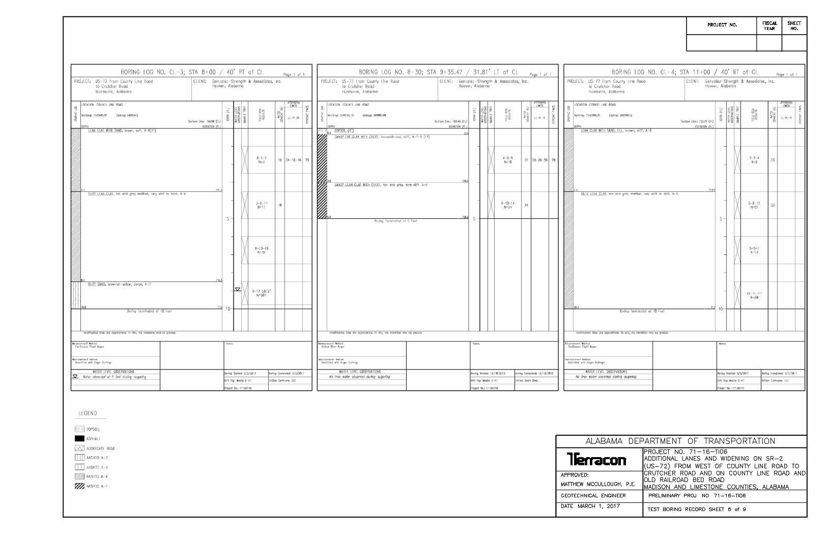
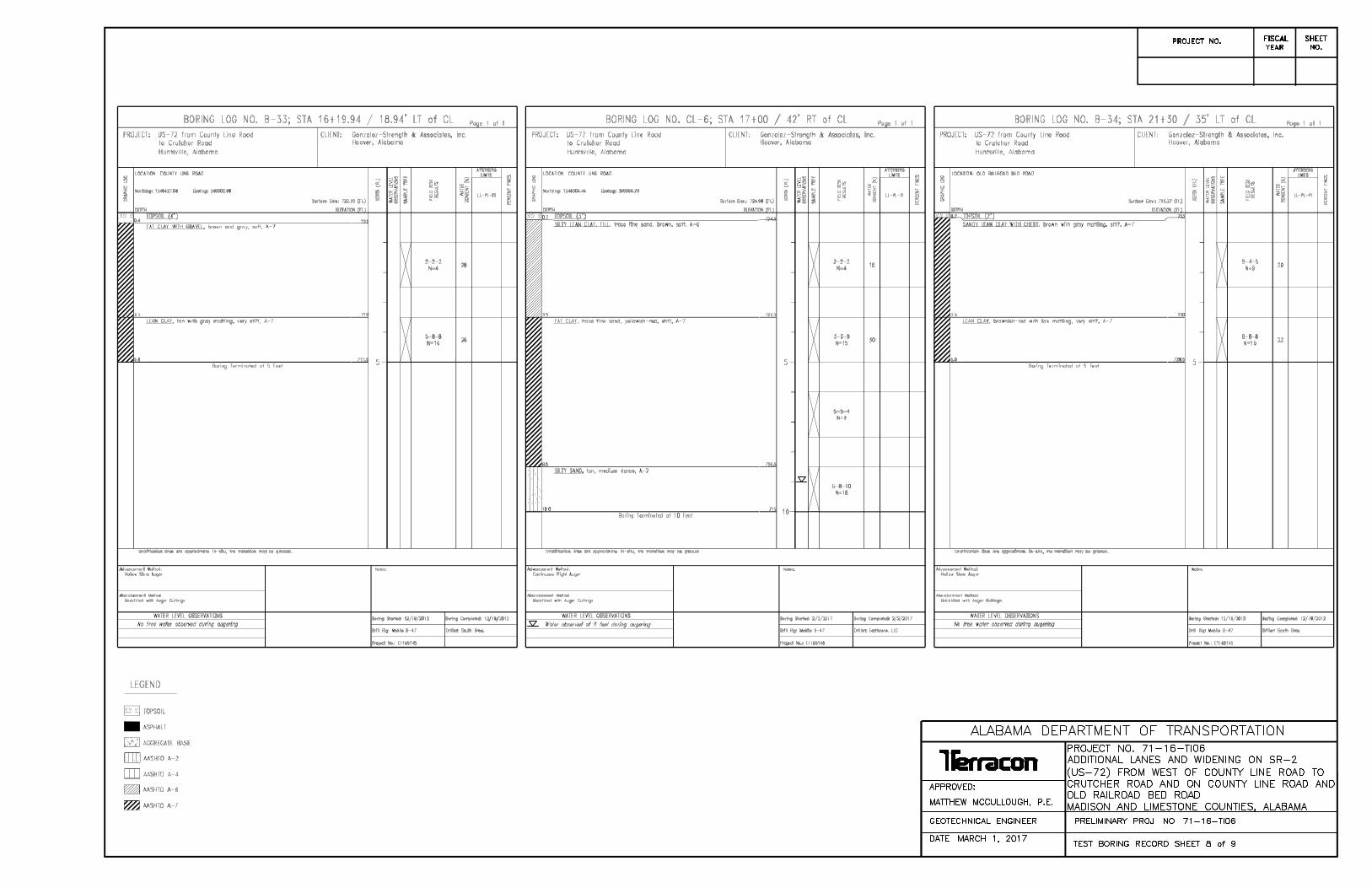
Drilling crews contracted by Terracon conducted soil boring and sampling operations atdesignated locations on the project site using both truck-mounted and ATV track-mounted drillrigs. The drill rigs were fitted with manual hammers. A total of twenty-seven (27) test boringswere performed for this project. Fourteen (14) of the borings were performed in 2012 as part ofa previous project. Thirteen (13) additional borings were performed on February 2, 2017 basedon the updated plans. The borings were performed approximately every 200 to 300 feet nearthe left and right ditch lines along County Line Road and Old Railroad Bed Road, and near theleft ditch line and centerline along SR-2 (US-72). The borings were extended to depths of 5 to10 feet below the existing grades. The soil boring locations are shown on Exhibits A-3 throughA-6 in Appendix A.
Boring logs indicating the location and depth of the drilling and sampling operations wereprepared by the driller in the field. Bagged soil samples from standard penetration testing wererecovered. A Terracon engineer evaluated the recovered soil samples and logged the probablesite stratigraphy. Selected soil samples were tested at the Terracon laboratories in Birmingham.Laboratory test results are included in this report in Appendix B.
4.0 SUBSURFACE CONDITIONS
4.1 Geology
Published maps indicate that the project is underlain by the Fort Payne Chert. This formationcontains very light to light-olive-gray, thin to thick-bedded fine to coarse-grained bioclastic(abundant pelmatozoans) limestone containing abundant nodules, lenses and beds of light todark-grey chert. For more information please see Exhibit A-1: Geologic Map located in AppendixA.
4.2 Existing Pavement
A cursory review of the existing pavement condition was performed as part of our fieldexploration. The existing pavement along SR-2 (US-72) was generally observed to be in goodcondition with only occasional low to moderate-severity longitudinal and transverse crackingobserved. Due to the low severity the cracking is not anticipated to penetrate the existingwearing surface layer.
The pavement along County Line Road was generally observed to be in fair to good condition,with moderate severity transverse and block cracks observed. However, areas near the

Soil Survey and Materials ReportAdditional Lanes and Widening on SR-2 (US-72) from West of County Line RoadTo Crutcher Road ■ Madison and Limestone Counties, AlabamaAugust 16, 2017 ■ Terracon Project E1165145
Responsive ■ Resourceful ■ Reliable 3
intersection with SR-2 (roughly between approximate Station 15+00 and 19+00) had severalpatched areas in poor condition.
The pavement along Old Railroad Bed Road was generally observed to be in fair to goodcondition, with moderate severity transverse cracking observed.
The existing pavement was cored at selected locations along SR-2 (US-72), County Line Road,and Old Railroad Bed Road. The encountered asphalt and base thicknesses are shown in thefollowing table. Photographs of the pavement cores can be seen on Exhibits A-7 through A-10in Appendix A.
Boring No. LocationTotal Thickness
of Asphalt(inches)
Thickness ofBase
(inches)
C-1 Sta. 109+00 / 35’ RT of CLSR-2 (US-72) 13 2*
C-2 Sta. 121+50 / 20’ LT of CLSR-2 (US-72) 7 5*
C-3 Sta. 23+75 / 20’ RT of CLOld Railroad Bed Road 4 4.5
C-4 Sta. 11+00 / 18’ LT of CLCounty Line Road 5 5*
*At Cores C-1, C-2, and C-4, the existing base could not be penetrated by hand-augering
The base material was noted to consist of crushed aggregate. The existing asphalt and basethickness observed at the boring locations correlate to an average in-place Structural Number(SN) of 4.89 for SR-2 (US-72), 2.9 for County Line Road, and 2.39 for Old Railroad Bed Road.
4.3 Subsurface Soil Conditions
Most borings initially encountered between 2 and 4 inches of topsoil. Boring B-35, performed onOld Railroad Bed Road, encountered 4 inches of asphalt and 2 inches of crushed aggregatebase. Below the surface material, the soils encountered at the borings generally consisted oflean clay (CL) and fat clay (CH). A few borings also encountered silt (ML) or silty sand (SM)below about 6 to 8-½ feet. The soils were typically AASHTO Classification A-6 and A-7-6 basedon laboratory testing. The borings were terminated at depths ranging from 5 to 10 feet belowexisting grades.
The soils encountered in the borings had typical SPT N-values ranging from about 4 blows perfoot to about 18 blows per foot, which correlates with soil consistencies of soft to very stiff. At afew locations, the clay soils had consistencies of hard (N-values 31 blows per foot or greater).

Soil Survey and Materials ReportAdditional Lanes and Widening on SR-2 (US-72) from West of County Line RoadTo Crutcher Road ■ Madison and Limestone Counties, AlabamaAugust 16, 2017 ■ Terracon Project E1165145
Responsive ■ Resourceful ■ Reliable 4
Boring B-42 (drilled at Sta. 116+95 of SR-2) encountered very soft soils (N-value of 2 blows perfoot) in the upper 4 feet. For a more detailed description of the subsurface conditionsencountered, please refer to the boring log sheets in Appendix D.
Selected soil samples were tested for properties such as natural moisture content (ASTM D-2216), grain-size distribution (ASTM D-422) and Atterberg Limits (ASTM D-4318). Ourlaboratory test results for the samples tested indicated that the on-site soils have PlasticityIndices (PI’s) ranging from 13 to about 37 percent and Liquid Limits (LL’s) ranging from 33 to 64percent. Laboratory test results are presented in the Soil Classification Summary in AppendixB.
A standard Proctor density test (AASHTO T99) and Laboratory Resilient Modulus (MR) test(AASHTO T 307-99) were performed on one composite bulk sample retrieved from boringsSR2-5 and SR2-6. The results are summarized in the following table.
Station Offset Depth(feet)
MaximumDry
Density(pcf)
OptimumMoistureContent
(%)
AverageMR
(psi)
AASHTOClassification
119+00122+00
25’ Right40’ Right 0-10 94.9 25.5 9,783 A-7-6(22)1
1. Specimen tested at 2.0 psi confining pressure; see Section 5.2.4 for further discussion of theLaboratory Resilient Modulus tests.
4.4 Groundwater
The following table presents the groundwater levels observed in our borings at the time ofdrilling and for the short duration that the borings were allowed to remain open after drillingcompletion.
Station Offset Boring No.
DepthGroundwater
Observed(feet)
ElevationGroundwater
Observed(feet)
109+00 60’ LT SR2-1 6 712.87109+00 CL SR2-2 7 712.79119+00 55’ LT SR2-4 7 729.458+00 40’ RT CL-3 9 715.9814+00 40’ RT CL-5 5 716.6317+00 42’ RT CL-6 9 715.98

Soil Survey and Materials ReportAdditional Lanes and Widening on SR-2 (US-72) from West of County Line RoadTo Crutcher Road ■ Madison and Limestone Counties, AlabamaAugust 16, 2017 ■ Terracon Project E1165145
Responsive ■ Resourceful ■ Reliable 5
No groundwater was noted in any of the other borings performed for this project. A relatively longperiod of time may be necessary for a groundwater level to develop and stabilize in a borehole inthese materials. Long term observations in piezometers or observation wells sealed from theinfluence of surface water are often required to define groundwater levels in materials of this type.
Groundwater level fluctuations occur due to seasonal variations in the amount of rainfall, runoffand other factors not evident at the time the borings were performed.
5.0 RECOMMENDATIONS FOR DESIGN AND CONSTRUCTION
5.1 Earthwork
Fills of up to about 4 feet will be required along the existing median on SR-2 (US-72). Fills of 1to 6 feet will be necessary in widening areas left of centerline along SR-2 (US-72). Fills of 1 to 3feet will be required for the County Line Road and Old Railroad Bed Road widening, left andright of centerline. Minimal cuts will be necessary in the proposed ditch lines.
5.1.1 Unclassified ExcavationThe unclassified materials excavation for this project will primarily consist of removal of a portionof the existing asphalt and crushed aggregate base. Based on the cross-sections provided to usby Gonzalez-Strength and Associates, Inc., and the data retrieved from our pavement cores, wehave estimated an unclassified materials excavation quantity of approximately 1,100 cubicyards for this project. This quantity does not include soft soil undercut (presented below).
Pay Item 210A-000 – Unclassified Excavation – per cubic yard
Based on the results of our borings along the proposed roadway widening areas, undercuttingof soft soils will be necessary in several areas. The table below presents our undercutrecommendations based on the borings. These areas should be further evaluated at the timethey are excavated and further delineation of soft soils may be required at the time ofconstruction. Soils removed during undercutting may be reused as borrow material beyond theedge of pavement.
Location Station Offset Boring(s)
AnticipatedUndercut
Depth(feet)
AnticipatedUndercut
Width(feet)
AnticipatedUndercutVolume
(CY)
SR-2 (US-72)116+00 –118+00
20’ Rightto 35’Right
B-42 4 15 445

Soil Survey and Materials ReportAdditional Lanes and Widening on SR-2 (US-72) from West of County Line RoadTo Crutcher Road ■ Madison and Limestone Counties, AlabamaAugust 16, 2017 ■ Terracon Project E1165145
Responsive ■ Resourceful ■ Reliable 6
Location Station Offset Boring(s)
AnticipatedUndercut
Depth(feet)
AnticipatedUndercut
Width(feet)
AnticipatedUndercutVolume
(CY)
SR-2 (US-72) 120+50 –122+50
10’ Rightto 35’Right
SR2-7 3 25 555
County LineRoad 7+50 – 8+50
25’ Rightto 50’Right
CL-3 3 25 278
County LineRoad 12+50 – 18+00
35’ Rightto 60’Right
CL-5CL-6 3 25 1,528
County LineRoad 15+00 – 17+00 35’ Left to
10’ Left B-33 3 25 556
Old RailroadBed Road 22+50 – 24+00
15’ Rightto 35’Right
B-35 3 20 333
5.1.2 Shrink/Swell ValuesWe recommend that a typical shrink value of 20-25% be assumed for on-site soils. This typicalvalue may also be applied to off-site borrow soils if laboratory testing is not available for thesesoils.
5.1.3 BorrowWe anticipate that the fill material for the project will be comprised of off-site soils. No off-siteborrow sources have been identified at the time of this report.
Pay Item No. 210D-000 – Borrow Excavation – per cubic yard
5.1.4 TopsoilBased on our site observations and the results of our borings, there does not appear to beadequate topsoil present at the site for re-use, or an adequate stockpiling area. The followingpay item is recommended for purchase of topsoil.
Pay Item No. 650A-000 – Topsoil – per cubic yard
It will be the responsibility of the contractor to verify the topsoil materials purchased meet therequirements set forth in Section 650.02(a) of the ALDOT Specifications for HighwayConstruction.

Soil Survey and Materials ReportAdditional Lanes and Widening on SR-2 (US-72) from West of County Line RoadTo Crutcher Road ■ Madison and Limestone Counties, AlabamaAugust 16, 2017 ■ Terracon Project E1165145
Responsive ■ Resourceful ■ Reliable 7
5.2 Pavement Design
5.2.1 Existing PavementPavement coring data is presented in Section 4.2 as well as in Appendix A. Based on the corescollected, the average in-place Structural Number (SN) is 4.89 for SR-2 (US-72), 2.9 for CountyLine Road, and 2.39 for Old Railroad Bed Road.
Portions of the existing pavement on US-72, County Line Road, and Old Railroad Bed Road willbe planed and retained throughout the project and will receive an overlay in conjunction with theplanned additional lanes/widening. Portions of the County Line Road and Old Railroad Bedpavement will also be removed and replaced adjacent to the intersection with US-72.
5.2.2 Traffic DataDesign traffic data was provided by GSA, and is included with this report in Appendix C. Theprovided traffic data for this project indicates a maximum 2017 Average Annual Daily Traffic(AADT) of 36,163, a 2037 AADT of 59,257, and a TADT of 3%. Based on these values,maximum project ESALs were calculated to be approximately 4,396,202 (4.4x10⁶) – withinESAL range C/D.
5.2.3 SubgradeThe soils that will comprise the new pavement subgrade will consist of either in-situ soils or newengineered fill. Due to the relatively short length of the project and lateral limits of the plannedwidening, it is our opinion that roadbed processing and/or roadbed stabilization should bewaved.
Plan Note: The upper 6 inches of subgrade should be compacted to 100% of theAASHTO T-99.
5.2.4 Design Resilient ModulusAs previously discussed in Section 4.3, one Resilient Modulus (MR) sample was tested for thisproject by Terracon. Based on the AASHTO soil classification, the sample was tested at aconfining pressure of 2 psi. The sample tested resulted in a design MR value of 9,800 psi. Thisdesign MR will only be utilized for design of the County Line Road and Old Railroad Bed Roadpavements. The laboratory MR results have been included with this report in Appendix B. TheDesign Resilient Modulus (MR) Summary Sheets are included in Appendix C.
5.2.5 Recommended Pavement BuildupThe following sections contain our recommended pavement buildups for this project. Theequivalent buildup method was utilized for design of the widening and resurfacing buildups onSR-2 (US-72). The design Resilient Modulus (MR) of 9,800 psi was utilized for design of thewidening and resurfacing buildups on County Line Road and Old Railroad Bed Road.

Soil Survey and Materials ReportAdditional Lanes and Widening on SR-2 (US-72) from West of County Line RoadTo Crutcher Road ■ Madison and Limestone Counties, AlabamaAugust 16, 2017 ■ Terracon Project E1165145
Responsive ■ Resourceful ■ Reliable 8
5.2.5.1 ResurfacingResurfacing is planned on US-72 for the entire length of the project, on County Line Roadbetween Stations 1+25 to 15+00 and 19+00 to 19+42.84, and on Old Railroad Bed Roadbetween Stations 23+50 to 26+00. The existing pavement in these areas will be planed andretained and overlaid. The recommended resurfacing buildups are presented below:
Section Item Thickness(inches)
SR-2 (US-72) Resurfacing Station 107+29.12 to
126+29.70
Equivalent Buildup Method
424A-360165 lb/yd2 Superpave Bituminous
Concrete Wearing Surface, ½ inchMaximum Aggregate Size Mix, ESAL
Range C/D
1.49
408A-051Planing Existing Pavement
(Approximately 0.00” through 1.0” Thick)(0.5”)
---
Existing Asphalt After Planing 6.5 to 12.5
Existing Crushed Aggregate Base 5.0
Section Item Thickness(inches)
TotalThickness(inches)
County Line RoadResurfacing
Station 23+50 to 26+00
Design MR = 9,800 psiDesign SN = 4.23Actual SN = 4.29
424A-360165 lb/yd2 Superpave Bituminous
Concrete Wearing Surface, ½ inchMaximum Aggregate Size Mix, ESAL
Range C/D
1.49
12.29
424B-651255 lb/yd2 Superpave Bituminous
Concrete Upper Binder Layer, 1 inchMaximum Aggregate Size Mix, ESAL
Range C/D
2.3
408A-052Planing Existing Pavement
(Approximately 1.10” through 2.0” Thick)(1.5”)
---
Existing Asphalt After Planing 3.5
Existing Crushed Aggregate Base 5.0

Soil Survey and Materials ReportAdditional Lanes and Widening on SR-2 (US-72) from West of County Line RoadTo Crutcher Road ■ Madison and Limestone Counties, AlabamaAugust 16, 2017 ■ Terracon Project E1165145
Responsive ■ Resourceful ■ Reliable 9
Section Item Thickness(inches)
TotalThickness(inches)
Old Railroad Bed RoadResurfacing
Station 1+25 to 15+00Station 19+00 to 19+42.84
Design MR = 9,800 psiDesign SN = 4.03Actual SN = 4.11
424A-360165 lb/yd2 Superpave Bituminous
Concrete Wearing Surface, ½ inchMaximum Aggregate Size Mix, ESAL
Range C/D
1.49
11.54
424B-651255 lb/yd2 Superpave Bituminous
Concrete Upper Binder Layer, 1 inchMaximum Aggregate Size Mix, ESAL
Range C/D
2.3
408A-051Planing Existing Pavement
(Approximately 0.00” through 1.0” Thick)(0.75”)
---
Existing Asphalt After Planing 3.25
Existing Crushed Aggregate Base 4.5
5.2.5.2 New PavementNew pavement will be required in reconstructed areas of County Line Road and Old RailroadBed Road as well as for widening and/or additional lanes on US-72, County Line Road, and OldRailroad Bed Road. The recommended new pavement buildups are presented in the followingtables:

Soil Survey and Materials ReportAdditional Lanes and Widening on SR-2 (US-72) from West of County Line RoadTo Crutcher Road ■ Madison and Limestone Counties, AlabamaAugust 16, 2017 ■ Terracon Project E1165145
Responsive ■ Resourceful ■ Reliable 10
Section Item Thickness(inches)
TotalThickness(inches)
SR-2 (US-72)Eastbound
Widening/Additional Lanes Station 107+29.12 to
126+29.70
Equivalent Buildup MethodDesign SN = 4.89Actual SN = 4.95
424A-360165 lb/yd2 Superpave Bituminous
Concrete Wearing Surface, ½ inchMaximum Aggregate Size Mix, ESAL
Range C/D
1.49
15.81
424B-651255 lb/yd2 Superpave Bituminous
Concrete Upper Binder Layer, 1 inchMaximum Aggregate Size Mix, ESAL
Range C/D
2.3
424B-681335 lb/yd2 Superpave Bituminous
Concrete Lower Binder Layer, 1 inchMaximum Aggregate Size Mix, ESAL
Range C/D
3.02
301A-006Crushed Aggregate Base Course, Type
B, Plant Mixed, 4.5” CompactedThickness
4.5
301A-006Crushed Aggregate Base Course, Type
B, Plant Mixed, 4.5” CompactedThickness
4.5
Falling Weight Deflectometer (FWD) testing performed by ALDOT in 2014 showed an additional1 inch of asphalt was required for the westbound travel lanes. At the request of ALDOT, thisinformation has been considered for the new pavement section on the westbound portion of thisproject presented below.

Soil Survey and Materials ReportAdditional Lanes and Widening on SR-2 (US-72) from West of County Line RoadTo Crutcher Road ■ Madison and Limestone Counties, AlabamaAugust 16, 2017 ■ Terracon Project E1165145
Responsive ■ Resourceful ■ Reliable 11
Section Item Thickness(inches)
TotalThickness(inches)
SR-2 (US-72)Westbound
Widening/Additional Lanes Station 107+29.12 to
126+29.70
Equivalent Buildup MethodDesign SN = 4.89Actual SN = 5.48
424A-360165 lb/yd2 Superpave Bituminous
Concrete Wearing Surface, ½ inchMaximum Aggregate Size Mix, ESAL
Range C/D
1.49
16.79
424B-651350 lb/yd2 Superpave Bituminous
Concrete Upper Binder Layer, 1 inchMaximum Aggregate Size Mix, ESAL
Range C/D
3.15
424B-681350 lb/yd2 Superpave Bituminous
Concrete Lower Binder Layer, 1 inchMaximum Aggregate Size Mix, ESAL
Range C/D
3.15
301A-006Crushed Aggregate Base Course, Type
B, Plant Mixed, 4.5” CompactedThickness
4.5
301A-006Crushed Aggregate Base Course, Type
B, Plant Mixed, 4.5” CompactedThickness
4.5

Soil Survey and Materials ReportAdditional Lanes and Widening on SR-2 (US-72) from West of County Line RoadTo Crutcher Road ■ Madison and Limestone Counties, AlabamaAugust 16, 2017 ■ Terracon Project E1165145
Responsive ■ Resourceful ■ Reliable 12
The following buildup is recommended for the new pavement on County Line Road.
Section Item Thickness(inches)
TotalThickness(inches)
County Line RoadReconstruction
Station 15+00 to 19+00
Widening/Additional LanesStation 1+25 to 15+00
Station 19+00 to 19+42.84
Design MR = 9,800 psiDesign SN = 4.39Actual SN = 4.40
424A-360165 lb/yd2 Superpave Bituminous
Concrete Wearing Surface, ½ inchMaximum Aggregate Size Mix, ESAL
Range C/D
1.49
12.58
424B-651255 lb/yd2 Superpave Bituminous
Concrete Upper Binder Layer, 1 inchMaximum Aggregate Size Mix, ESAL
Range C/D
2.3
424B-681310 lb/yd2 Superpave Bituminous
Concrete Lower Binder Layer, 1 inchMaximum Aggregate Size Mix, ESAL
Range C/D
2.79
301A-012Crushed Aggregate Base Course, Type
B, Plant Mixed, 6” Compacted Thickness6

Soil Survey and Materials ReportAdditional Lanes and Widening on SR-2 (US-72) from West of County Line RoadTo Crutcher Road ■ Madison and Limestone Counties, AlabamaAugust 16, 2017 ■ Terracon Project E1165145
Responsive ■ Resourceful ■ Reliable 13
The following buildup is recommended for the new pavement on Old Railroad Bed Road.
Section Item Thickness(inches)
TotalThickness(inches)
Old Railroad Bed RoadReconstruction
Station 20+50.95 to 23+50
Widening/Additional LanesStation 23+50 to 26+00
Design MR = 9,800 psiDesign SN = 4.20Actual SN = 4.23
424A-360165 lb/yd2 Superpave Bituminous
Concrete Wearing Surface, ½ inchMaximum Aggregate Size Mix, ESAL
Range C/D
1.49
12.27
424B-651255 lb/yd2 Superpave Bituminous
Concrete Upper Binder Layer, 1 inchMaximum Aggregate Size Mix, ESAL
Range C/D
2.3
424B-681275 lb/yd2 Superpave Bituminous
Concrete Lower Binder Layer, 1 inchMaximum Aggregate Size Mix, ESAL
Range C/D
2.48
301A-012Crushed Aggregate Base Course, Type
B, Plant Mixed, 6” Compacted Thickness6
It may be necessary to relocate existing private driveways to accommodate the associatedconstruction. The pavement designs shown below may be used for bituminous and concreteresidential driveways without curb and gutter sections. Private drives affected will bereconstructed in kind with similar materials. A plan note will be required for driveway locationsstating the subgrade is to be compacted to the satisfaction of the engineer.
Section Item Thickness(inches)
TotalThickness(inches)
Private Asphalt Driveways
424A-360165 lb/yd2 Superpave Bituminous Concrete
Wearing Surface, ½ inch MaximumAggregate Size Mix, ESAL Range C/D
1.49
3.79424B-651
255 lb/yd2 Superpave Bituminous ConcreteUpper Binder Layer, 1 inch MaximumAggregate Size Mix, ESAL Range C/D
2.3

Soil Survey and Materials ReportAdditional Lanes and Widening on SR-2 (US-72) from West of County Line RoadTo Crutcher Road ■ Madison and Limestone Counties, AlabamaAugust 16, 2017 ■ Terracon Project E1165145
Responsive ■ Resourceful ■ Reliable 14
Section Item Thickness(inches)
TotalThickness(inches)
Private ConcreteDriveways
618B-003Concrete Driveway, 6” thick (Includes Wire
Mesh)6 6
5.2.6 RAP Information
For evaluation with regard to the use of Reclaimed Asphalt Pavement (RAP), The Job MixFormula sheet from the previous resurfacing project on SR-2 (US-72) has been included withthis report in Appendix C. The mix design indicates an asphalt content of 5.5% and the followingaggregate gradation:
Sieve Size % Passing1/2” 1003/8” 98#4 70#8 50
#16 41#30 30#50 13#100 8#200 6
The following table shows the coarse aggregate types utilized in the mix and theircorresponding LA Abrasion values:
Description Source % of Mix LA Abrasion1
3/8” Steel SlagDecatur Mills;
Trinity AL 10 16
#89 Limestone Vulcan Materials;Huntsville, AL 22 27
#810 Limestone Vulcan Materials;Huntsville, AL 6 27
#8 Sandstone Madison Materials;Blountsville, AL 10 53
1. Per ALDOT Materials Sources and Devices with Special AcceptanceRequirements Manual

Soil Survey and Materials ReportAdditional Lanes and Widening on SR-2 (US-72) from West of County Line RoadTo Crutcher Road ■ Madison and Limestone Counties, AlabamaAugust 16, 2017 ■ Terracon Project E1165145
Responsive ■ Resourceful ■ Reliable 15
5.3 Miscellaneous
Typical details for curb and gutter sections as well as open cut details for roadway pipe have beenprovided by Gonzalez-Strength and Associates and are included with this report in Appendix C.
A prime coat should be applied over the crushed aggregate base layer. A tack coat will be requiredfor bituminous concrete overlays and other contact surfaces such as adjacent pavement edges.ALDOT requires that a joint sealant be used during longitudinal and transverse joint construction.
Pay Item No. 401A-000 – Bituminous Treatment A – per square yard
Pay Item No. 405A-000 – Tack Coat – per gallon
Pay Item No. 407B-000 – Joint Sealant for Hot Mix Asphalt Pavement – per mile
A minor amount of patching (approximately 200 tons) of the existing pavement may be necessary.The following pay item is recommended.
Pay Item No. 424B-685 – Superpave Bituminous Concrete Lower Binder Layer, Patching, 1inch Maximum Aggregate Size Mix, ESAL Range C/D – per ton
Leveling pay items will be required for correcting cross slope on US-72, County Line Road, and OldRailroad Bed Road.
Pay Item No. 424B-659 – Superpave Bituminous Concrete Upper Binder Layer, Leveling, 1inch Maximum Aggregate Size Mix, ESAL Range C/D – per ton
Per the ALDOT Guidelines for Operation the recommended minimum placement rate for the binderleveling is 125 pounds per square yard, and the maximum rate is 350 pounds per square yard.
In order to minimize the potential for segregation, we recommend the use of a materials transferdevice.
Pay Item No. 410H-000 – Material Remixing Device – each
Where pavement is being raised more than one inch along shoulder areas and to repair lowshoulders, aggregate surfacing is recommended.
Pay Item No. 430B-043 – Aggregate Surfacing (1” Down, Crusher Run) – per ton

Soil Survey and Materials ReportAdditional Lanes and Widening on SR-2 (US-72) from West of County Line RoadTo Crutcher Road ■ Madison and Limestone Counties, AlabamaAugust 16, 2017 ■ Terracon Project E1165145
Responsive ■ Resourceful ■ Reliable 16
A field laboratory will be required for onsite testing and storage of samples and testingequipment. The following item should be included.
Pay Item 601A-000 – Furnishing Base, Soil and Structures Lab – each

APPENDIX A:FIGURES
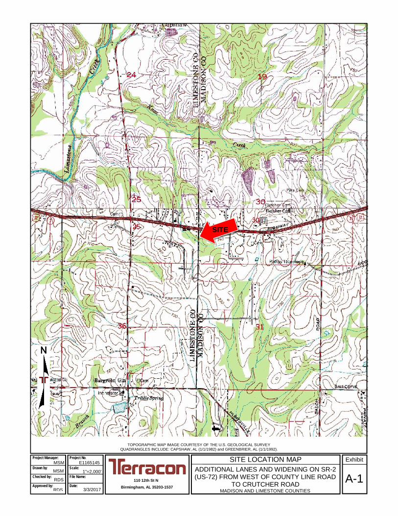
SITE LOCATION MAPADDITIONAL LANES AND WIDENING ON SR-2(US-72) FROM WEST OF COUNTY LINE ROAD
TO CRUTCHER ROADMADISON AND LIMESTONE COUNTIES
Huntsville, AL
TOPOGRAPHIC MAP IMAGE COURTESY OF THE U.S. GEOLOGICAL SURVEYQUADRANGLES INCLUDE: CAPSHAW, AL (1/1/1982) and GREENBRIER, AL (1/1/1992).
110 12th St NBirmingham, AL 35203-1537
E1165145Project Manager:
Drawn by:
Checked by:
Approved by:
MSM
RDS
RDS
1”=2,000’
3/3/2017
Project No.
Scale:
File Name:
Date:A-1
ExhibitMSM
SITE

Fort Payne Chert - Very light to light-olive-gray, thin to thick-bedded fine to coarse-grained bioclastic (abundant pelmatozoans)limestone containing abundant nodules,lenses and beds of light to dark-grey chert.
Hartselle Sandstone - Light-colored thick-bedded to massive quartzose sandstone,containing interbeds of dark-gray shale.
GEOLOGIC MAPADDITIONAL LANES AND WIDENING ON SR-2(US-72) FROM WEST OF COUNTY LINE ROAD
TO CRUTCHER ROADMADISON AND LIMESTONE COUNTIES
110 12th St NBirmingham, AL 35203-1537
DIAGRAM IS FOR GENERAL LOCATION ONLY, AND ISNOT INTENDED FOR CONSTRUCTION PURPOSES
E1165145
MSM
RDS
RDS
NTS
3/3/2017
Scale:
A-2
ExhibitProject Manager:
Drawn by:
Checked by:
Approved by:
Project No.
File Name:
Date:
MSM

BORING LOCATION PLANADDITIONAL LANES AND WIDENING ON SR-2 (US-72) FROM
WEST OF COUNTY LINE ROAD TO CRUTCHER ROADMADISON AND LIMESTONE COUNTIES A-3
110 12th Street North Birmingham, Alabama 35203
PH. (205) 942-1289 FAX. (205) 443-5302
E1165145
3/3/2017
MSM
MSM
RDS
RDS
N.T.S.
Project Manager:
Drawn by:
Checked by:
Approved by:
Project No.
Scale:
File Name:
Date:
EXHIBIT
DIAGRAM IS FOR GENERAL LOCATION ONLY, AND IS NOTINTENDED FOR CONSTRUCTION PURPOSES
B-39B-40
SR2-1
BORING LOCATION ASPHALT CORE LOCATION
SR2-2
B-41 B-42
SR2-4
SR2-5C-1

BORING LOCATION PLANADDITIONAL LANES AND WIDENING ON SR-2 (US-72) FROM
WEST OF COUNTY LINE ROAD TO CRUTCHER ROADMADISON AND LIMESTONE COUNTIES A-4
110 12th Street North Birmingham, Alabama 35203
PH. (205) 942-1289 FAX. (205) 443-5302
E1165145
3/3/2017
MSM
MSM
RDS
RDS
N.T.S.
Project Manager:
Drawn by:
Checked by:
Approved by:
Project No.
Scale:
File Name:
Date:
EXHIBIT
DIAGRAM IS FOR GENERAL LOCATION ONLY, AND IS NOTINTENDED FOR CONSTRUCTION PURPOSES
SR2-6
BORING LOCATION ASPHALT CORE LOCATION
SR2-7
C-2

BORING LOCATION PLANADDITIONAL LANES AND WIDENING ON SR-2 (US-72) FROM
WEST OF COUNTY LINE ROAD TO CRUTCHER ROADMADISON AND LIMESTONE COUNTIES A-5
110 12th Street North Birmingham, Alabama 35203
PH. (205) 942-1289 FAX. (205) 443-5302
E1165145
3/3/2017
MSM
MSM
RDS
RDS
N.T.S.
Project Manager:
Drawn by:
Checked by:
Approved by:
Project No.
Scale:
File Name:
Date:
EXHIBIT
DIAGRAM IS FOR GENERAL LOCATION ONLY, AND IS NOTINTENDED FOR CONSTRUCTION PURPOSES
B-29B-28
CL-2 CL-3CL-1
B-27 B-32
BORING LOCATION
B-31
CL-4
B-30
ASPHALT CORE LOCATION
CL-5
C-4

BORING LOCATION PLANADDITIONAL LANES AND WIDENING ON SR-2 (US-72) FROM
WEST OF COUNTY LINE ROAD TO CRUTCHER ROADMADISON AND LIMESTONE COUNTIES A-6
110 12th Street North Birmingham, Alabama 35203
PH. (205) 942-1289 FAX. (205) 443-5302
E1165145
3/3/2017
MSM
MSM
RDS
RDS
N.T.S.
Project Manager:
Drawn by:
Checked by:
Approved by:
Project No.
Scale:
File Name:
Date:
EXHIBIT
DIAGRAM IS FOR GENERAL LOCATION ONLY, AND IS NOTINTENDED FOR CONSTRUCTION PURPOSES
B-34 CL-7
CL-6
B-33
BORING LOCATION
B-36B-35
ASPHALT CORE LOCATION
C-3

ASPHALT CORE NO. C-1ADDITIONAL LANES AND WIDENING ON SR-2 (US-72) FROM
WEST OF COUNTY LINE ROAD TO CRUTCHER ROADMADISON AND LIMESTONE COUNTIES
A-7
E1165145MSM
NTS
Project Manager:
Drawn by:
Checked by:
Approved by:
Project No.
Scale:
File Name:
Date:
Exhibit
DIAGRAM IS FOR GENERAL INFORMATIONONLY, AND IS NOT INTENDED FOR
CONSTRUCTION PURPOSES
MSM
110 12th Street North Birmingham, Alabama 35203
PH. (205) 942-1289 FAX. (205) 443-5302
Approximate Station 109+00, 35’ Right of Centerline SR-2 (US-72)
03/7/2017

ASPHALT CORE NO. C-2ADDITIONAL LANES AND WIDENING ON SR-2 (US-72) FROM
WEST OF COUNTY LINE ROAD TO CRUTCHER ROADMADISON AND LIMESTONE COUNTIES
A-8
E1145026MSM
NTS
Project Manager:
Drawn by:
Checked by:
Approved by:
Project No.
Scale:
File Name:
Date:
Exhibit
DIAGRAM IS FOR GENERAL INFORMATIONONLY, AND IS NOT INTENDED FOR
CONSTRUCTION PURPOSES
MSM
110 12th Street North Birmingham, Alabama 35203
PH. (205) 942-1289 FAX. (205) 443-5302
Approximate Station 121+50, 20’ Left of Centerline SR-2 (US-72)
03/7/2017

ASPHALT CORE NO. C-3ADDITIONAL LANES AND WIDENING ON SR-2 (US-72) FROM
WEST OF COUNTY LINE ROAD TO CRUTCHER ROADMADISON AND LIMESTONE COUNTIES
A-9
E1145026MSM
NTS
Project Manager:
Drawn by:
Checked by:
Approved by:
Project No.
Scale:
File Name:
Date:
Exhibit
DIAGRAM IS FOR GENERAL INFORMATIONONLY, AND IS NOT INTENDED FOR
CONSTRUCTION PURPOSES
MSM
110 12th Street North Birmingham, Alabama 35203
PH. (205) 942-1289 FAX. (205) 443-5302
Approximate Station 23+75, 20’ Right of Centerline Old Railroad Bed Road
03/7/2017

ASPHALT CORE NO. C-4ADDITIONAL LANES AND WIDENING ON SR-2 (US-72) FROM
WEST OF COUNTY LINE ROAD TO CRUTCHER ROADMADISON AND LIMESTONE COUNTIES
A-10
E1145026MSM
NTS
Project Manager:
Drawn by:
Checked by:
Approved by:
Project No.
Scale:
File Name:
Date:
Exhibit
DIAGRAM IS FOR GENERAL INFORMATIONONLY, AND IS NOT INTENDED FOR
CONSTRUCTION PURPOSES
MSM
110 12th Street North Birmingham, Alabama 35203
PH. (205) 942-1289 FAX. (205) 443-5302
Approximate Station 11+00, 18’ Left of Centerline County Line Road
03/7/2017

APPENDIX B:LABORATORY TESTING

Sheet 1 of 1
Station & Offset Boring Sample Depth Water Liquid Plastic Plasticity % Gravel % Sand % Pass D50 USCS AASHTONo. ID (ft) Content Limit Limit Index 200 (mm) Classification
(%)3+50 / 30' RT of CL CL-1 CL-1-1 1.0 – 2.5 32.3 55 27 28 12.8 11.8 75.4 --- CH A-7-6 (22)8+00 / 40' RT of CL CL-3 CL-3-1 1.0 – 2.5 19.4 34 18 16 6.5 14.7 78.8 --- CL A-6 (11)
14+00 / 40' RT of CL CL-5 CL-5-2 3.5 – 5.0 19.8 33 16 17 5.8 15.1 79.1 --- CL A-6 (12)24+00 / 30' LT of CL CL-7 CL-7-1 1.0 – 2.5 20.8 44 22 22 11.2 12.0 76.8 --- CL A-7-6 (17)
109+00 / 60' LT of CL SR2-1 SR2-1-1 1.0 – 2.5 43.3 62 27 35 7.7 17.3 75.0 --- CH A-7-6 (27)109+00 / CL SR2-2 SR2-2-2 3.5 – 5.0 48.4 64 27 37 26.5 24.3 49.2 0.087 GC A-7-6 (14)
119+00 / 55' LT of CL SR2-4 SR2-4-1 1.0 – 2.5 22.0 37 17 20 7.7 14.4 77.9 --- CL A-6 (14)119+00 / 25' RT of CL122+00 / 40' LT of CL SR2-5/SR2-6 BULK 0.0 – 10.0 --- 54 29 25 5.3 14.4 80.3 --- CH A-7-6 (22)
119+00 / 25' RT of CL SR2-5 SR2-5-2 3.5 – 5.0 25.1 35 22 13 7.3 17.1 75.6 --- CL A-6 (9)
SOIL CLASSIFICATION SUMMARYCity of Huntsville71-16-TI06Additional Lanes on SR-2 (US-72) From West of County Line RoadTo Crutcher Road and on County Line Road and Old Railroad Bed RoadGrade, Drain, Base, Pave, Signing, and SignalsMadison and Limestone Counties

Resilient Modulus of Subgrade Soils and Untreated Base/Subbase Materials(RECOMPACTED / THINWALL TUBE SAMPLES)
LABORATORY: Boudreau Engineering, Inc. PROJECT NAME: US-72 (County Line Rd - Crutcher Rd)Lawrenceville, Georgia PROJECT NO.: Terracon #E1165145
DATE RECEIVED: 02-16-2017 QUANTITY (REPRESENTED): N.A.IDENTIFICATION MARKS: SR-2-5 SOURCE OF MATERIAL: SR-2-5 (0-10ft)
1. SAMPLING DATE: N.R.2. SAMPLE NUMBER: SR-2-53. LAYER TYPE (1 - Subgrade, 2 - Base/Subbase) 14. MATERIAL TYPE (Type 1 or Type 2) 25. APPROX. DISTANCE FROM TOP OF SUBGRADE TO SAMPLE, ft (for tube samples) N/A6. TEST INFORMATION PRECONDITIONING - GREATER THAN 5% PERM. STRAIN? (Y = YES OR N = NO) N TESTING - GREATER THAN 5% PERM. STRAIN? (Y = YES OR N = NO) N TESTING - NUMBER OF LOAD SEQUENCES COMPLETED (0 - 15) 157. SPECIMEN INFO .: SPECIMEN DIAM., inch
TOP 2.9MIDDLE 2.9BOTTOM 2.9AVERAGE 2.9MEMBRANE THICKNESS (1), inch 0.00MEMBRANE THICKNESS (2), inch 0.00
NET DIAM., inch 2.9 HEIGHT OF SPECIMEN, CAP AND BASE, inch 5.61 HEIGHT OF CAP AND BASE, inch 0.0 INITIAL LENGTH, Lo , inch 5.6 INITIAL AREA, Ao , in^2 6.5 INITIAL VOLUME Ao Lo , in^3 36.5 INITIAL WEIGHT , grams (for tube samples) N/A8. SOIL SPECIMEN WEIGHT(for remolded samples) : INITIAL WEIGHT OF CONTAINER AND WET SOIL, grams 1118.45 FINAL WEIGHT OF CONTAINER AND WET SOIL, grams 0.00 WEIGHT OF WET SOIL USED , grams 1118.459. SOIL PROPERTIES .: For Remolded Samples: IN SITU MOISTURE CONTENT (NUCLEAR), % N/A IN SITU WET DENSITY (NUCLEAR), pcf N/A or OPTIMUM MOISTURE CONTENT, % 25.5 MAX. DRY DENSITY, pcf 94.9 For Tube Samples: IN SITU MOISTURE CONTENT , % N/A MOISTURE CONTENT AFTER RESILIENT MODULUS TESTING, % N/A WET DENSITY, pcf N/A DRY DENSITY, pcf N/A10. SPECIMEN PROPERTIES (for remolded samples): COMPACTION MOISTURE CONTENT, % 29.0 MOISTURE CONTENT AFTER RESILIENT MODULUS TESTING, % 28.9 COMPACTION DRY DENSITY, gd, pcf 90.6 TARGET DRY DENSITY, % gd 96 TARGET MOISTURE CONTENT, % 29.0 COMPACTION LEVEL ACHIEVED 95.5%11. QUICK SHEAR TEST STRESS - STRAIN PLOT ATTACHED (Y = YES, N = NO) Y TRIAXIAL SHEAR MAXIMUM STRENGTH (MAX. LOAD/X-SECTION AREA), psi 29 SPECIMEN FAIL DURING TRIAXIAL SHEAR? (Y = YES, N = NO) N12. TEST DATE 02-17-2017
13. GENERAL REMARKS:
TESTED BY RLB DATE 02-17-2017
Report Form X1.2/X1.3
AASHTO T 307-99

1. PROJECT NO(S): Terracon #E1165145 LABORATORY: Boudreau Engineering, Inc.2. PROJECT NAME: US-72 (County Line Rd - Crutcher Rd) Lawrenceville, Georgia3. SOURCE OF MATERIAL: SR-2-5 (0-10ft)4. REMOLDING TARGETS: 96% Maximum Dry Density at 29% Moisture Content
5. LAYER TYPE (1 - subgrade, 2 - base/subbase) 16. MATERIAL TYPE (Type 1 or Type 2) 27. TEST DATE 02-17-20178. RESILIENT MODULUS TESTING
COLUMN # 1 2 3 4 5 6 7 8 9 10 11 12 13 14Chamber Nominal Cycle Actual Actual Actual Actual Actual Actual Recov. Def. Recov. Def. Average Resilient Resilient
Confining Maximum No. Applied Applied Applied Applied Applied Applied LVDT LVDT Recov Def. Strain Modulus
PARAMETER Pressure Axial Max. Axial Cyclic Load Contact Max. Cyclic Contact #1 Reading #2 Reading LVDT 1
Stress Load Load Axial Stress Stress and 2
StressDESIGNATION S3 Scyclic c1 Pmax Pcyclic Pcontact Smax Scyclic Scontact H1 H2 Havg er Mr
UNIT psi psi --- lbs lbs lbs psi psi psi in in in in/in psiPRECISION _ _ _ ._ _ _ _ ._ _ _ _ _ _ ._ _ _ _ ._ _ _ _ ._ _ _ _ ._ _ _ _ ._ _ _ ._ _ ._ _ _ _ _ _ ._ _ _ _ _ _ ._ _ _ _ _ _ ._ _ _ _ _ _ _ _ .
6.0 2.0 96 13.4 12.0 1.4 2.1 1.8 0.2 0.00074 0.00074 0.00074 0.00013 13,992
97 13.3 11.9 1.4 2.1 1.8 0.2 0.00075 0.00074 0.00074 0.00013 13,874
SEQUENCE 1 98 13.4 12.1 1.4 2.1 1.9 0.2 0.00074 0.00075 0.00075 0.00013 13,983
99 13.4 12.1 1.3 2.1 1.9 0.2 0.00075 0.00074 0.00074 0.00013 14,048
100 13.4 12.1 1.4 2.1 1.9 0.2 0.00075 0.00075 0.00075 0.00013 13,965
COLUMN AVERAGE 13.4 12.0 1.4 2.1 1.9 0.2 0.00075 0.00074 0.00074 0.00013 13,972
STANDARD DEV. 0.0 0.1 0.0 0.0 0.0 0.0 0.00000 0.00000 0.00000 0.00000 63
Resilient Modulus of Subgrade Soils and Untreated Base/Subbase MaterialsAASHTO T307-99 REPORT FORM X1.1
Report Form X1.1

Project Name: US-72 (County Line Rd - Crutcher Rd) Identification Marks: SR-2-5 Material Source: SR-2-5 (0-10ft)
6.0 4.0 96 26.0 23.5 2.5 4.0 3.6 0.4 0.00158 0.00157 0.00158 0.00028 12,864
97 26.0 23.6 2.5 4.0 3.6 0.4 0.00157 0.00157 0.00157 0.00028 12,912
SEQUENCE 2 98 26.1 23.6 2.5 4.0 3.6 0.4 0.00157 0.00158 0.00157 0.00028 12,914
99 26.1 23.6 2.5 4.0 3.6 0.4 0.00158 0.00156 0.00157 0.00028 12,947
100 26.1 23.6 2.5 4.0 3.6 0.4 0.00157 0.00157 0.00157 0.00028 12,950
COLUMN AVERAGE 26.1 23.6 2.5 4.0 3.6 0.4 0.00157 0.00157 0.00157 0.00028 12,917
STANDARD DEV. 0.0 0.0 0.0 0.0 0.0 0.0 0.00000 0.00000 0.00000 0.00000 35
6.0 6.0 96 38.3 34.5 3.8 5.9 5.3 0.6 0.00273 0.00273 0.00273 0.00049 10,914
97 38.3 34.5 3.8 5.9 5.3 0.6 0.00272 0.00274 0.00273 0.00049 10,897
SEQUENCE 3 98 38.2 34.4 3.8 5.9 5.3 0.6 0.00273 0.00273 0.00273 0.00049 10,874
99 38.3 34.5 3.8 5.9 5.3 0.6 0.00272 0.00274 0.00273 0.00049 10,904
100 38.3 34.5 3.8 5.9 5.3 0.6 0.00271 0.00274 0.00273 0.00049 10,922
COLUMN AVERAGE 38.3 34.5 3.8 5.9 5.3 0.6 0.00272 0.00274 0.00273 0.00049 10,902
STANDARD DEV. 0.0 0.0 0.0 0.0 0.0 0.0 0.00001 0.00000 0.00000 0.00000 18
6.0 8.0 96 50.1 45.0 5.1 7.7 6.9 0.8 0.00412 0.00412 0.00412 0.00073 9,427
97 50.1 45.0 5.1 7.7 6.9 0.8 0.00411 0.00412 0.00412 0.00073 9,423
SEQUENCE 4 98 50.0 44.9 5.1 7.7 6.9 0.8 0.00410 0.00412 0.00411 0.00073 9,416
99 50.0 44.9 5.0 7.7 6.9 0.8 0.00411 0.00411 0.00411 0.00073 9,422
100 50.1 45.0 5.1 7.7 6.9 0.8 0.00411 0.00412 0.00412 0.00073 9,428
COLUMN AVERAGE 50.0 45.0 5.1 7.7 6.9 0.8 0.00411 0.00412 0.00411 0.00073 9,423
STANDARD DEV. 0.0 0.0 0.0 0.0 0.0 0.0 0.00000 0.00001 0.00000 0.00000 5
6.0 10.0 96 61.3 54.9 6.4 9.4 8.4 1.0 0.00556 0.00557 0.00556 0.00099 8,514
97 61.4 55.1 6.4 9.4 8.5 1.0 0.00556 0.00557 0.00556 0.00099 8,535
SEQUENCE 5 98 61.4 55.0 6.4 9.4 8.5 1.0 0.00555 0.00557 0.00556 0.00099 8,534
99 61.4 55.0 6.4 9.4 8.5 1.0 0.00556 0.00557 0.00556 0.00099 8,536
100 61.4 55.0 6.4 9.4 8.5 1.0 0.00555 0.00556 0.00556 0.00099 8,543
COLUMN AVERAGE 61.4 55.0 6.4 9.4 8.5 1.0 0.00556 0.00557 0.00556 0.00099 8,533
STANDARD DEV. 0.0 0.1 0.0 0.0 0.0 0.0 0.00000 0.00000 0.00000 0.00000 11
Report Form X1.1

Project Name: US-72 (County Line Rd - Crutcher Rd) Identification Marks: SR-2-5 Material Source: SR-2-5 (0-10ft)
4.0 2.0 96 13.7 11.9 1.8 2.1 1.8 0.3 0.00079 0.00080 0.00079 0.00014 12,966
97 13.7 11.9 1.8 2.1 1.8 0.3 0.00080 0.00080 0.00080 0.00014 12,832
SEQUENCE 6 98 13.7 12.0 1.8 2.1 1.8 0.3 0.00079 0.00080 0.00080 0.00014 12,954
99 13.8 12.0 1.7 2.1 1.9 0.3 0.00080 0.00080 0.00080 0.00014 13,003
100 13.7 12.0 1.8 2.1 1.8 0.3 0.00079 0.00080 0.00080 0.00014 12,981
COLUMN AVERAGE 13.7 12.0 1.8 2.1 1.8 0.3 0.00079 0.00080 0.00080 0.00014 12,947
STANDARD DEV. 0.0 0.1 0.0 0.0 0.0 0.0 0.00000 0.00000 0.00000 0.00000 67
4.0 4.0 96 25.8 23.3 2.5 4.0 3.6 0.4 0.00169 0.00171 0.00170 0.00030 11,846
97 25.8 23.3 2.5 4.0 3.6 0.4 0.00169 0.00171 0.00170 0.00030 11,808
SEQUENCE 7 98 25.8 23.3 2.5 4.0 3.6 0.4 0.00169 0.00171 0.00170 0.00030 11,822
99 25.8 23.4 2.5 4.0 3.6 0.4 0.00170 0.00171 0.00171 0.00030 11,792
100 25.9 23.4 2.5 4.0 3.6 0.4 0.00169 0.00171 0.00170 0.00030 11,859
COLUMN AVERAGE 25.8 23.4 2.5 4.0 3.6 0.4 0.00170 0.00171 0.00170 0.00030 11,826
STANDARD DEV. 0.0 0.0 0.0 0.0 0.0 0.0 0.00000 0.00000 0.00000 0.00000 27
4.0 6.0 96 38.2 34.5 3.8 5.9 5.3 0.6 0.00280 0.00281 0.00281 0.00050 10,593
97 38.2 34.5 3.8 5.9 5.3 0.6 0.00280 0.00282 0.00281 0.00050 10,582
SEQUENCE 8 98 38.2 34.5 3.8 5.9 5.3 0.6 0.00279 0.00282 0.00281 0.00050 10,591
99 38.3 34.5 3.7 5.9 5.3 0.6 0.00279 0.00282 0.00280 0.00050 10,613
100 38.2 34.4 3.8 5.9 5.3 0.6 0.00279 0.00282 0.00280 0.00050 10,594
COLUMN AVERAGE 38.2 34.5 3.8 5.9 5.3 0.6 0.00279 0.00282 0.00281 0.00050 10,595
STANDARD DEV. 0.0 0.0 0.0 0.0 0.0 0.0 0.00001 0.00000 0.00000 0.00000 11
4.0 8.0 96 50.1 45.1 5.1 7.7 6.9 0.8 0.00414 0.00416 0.00415 0.00074 9,363
97 50.0 44.9 5.1 7.7 6.9 0.8 0.00414 0.00417 0.00415 0.00074 9,339
SEQUENCE 9 98 50.1 45.0 5.1 7.7 6.9 0.8 0.00414 0.00417 0.00416 0.00074 9,340
99 50.2 45.1 5.1 7.7 6.9 0.8 0.00414 0.00417 0.00415 0.00074 9,368
100 50.1 45.1 5.1 7.7 6.9 0.8 0.00414 0.00417 0.00415 0.00074 9,361
COLUMN AVERAGE 50.1 45.0 5.1 7.7 6.9 0.8 0.00414 0.00417 0.00415 0.00074 9,354
STANDARD DEV. 0.1 0.1 0.0 0.0 0.0 0.0 0.00000 0.00000 0.00000 0.00000 14
Report Form X1.1

Project Name: US-72 (County Line Rd - Crutcher Rd) Identification Marks: SR-2-5 Material Source: SR-2-5 (0-10ft)
4.0 10.0 96 61.4 55.0 6.4 9.4 8.5 1.0 0.00570 0.00572 0.00571 0.00102 8,309
97 61.4 55.1 6.4 9.4 8.5 1.0 0.00569 0.00572 0.00570 0.00102 8,325
SEQUENCE 10 98 61.4 55.1 6.4 9.4 8.5 1.0 0.00570 0.00572 0.00571 0.00102 8,317
99 61.4 55.0 6.4 9.4 8.5 1.0 0.00569 0.00572 0.00571 0.00102 8,318
100 61.5 55.1 6.4 9.5 8.5 1.0 0.00570 0.00570 0.00570 0.00102 8,331
COLUMN AVERAGE 61.4 55.0 6.4 9.4 8.5 1.0 0.00570 0.00571 0.00571 0.00102 8,320
STANDARD DEV. 0.0 0.0 0.0 0.0 0.0 0.0 0.00000 0.00001 0.00000 0.00000 9
2.0 2.0 96 14.1 11.9 2.2 2.2 1.8 0.3 0.00086 0.00086 0.00086 0.00015 11,902
97 14.0 11.9 2.2 2.2 1.8 0.3 0.00087 0.00086 0.00086 0.00015 11,847
SEQUENCE 11 98 14.1 11.9 2.2 2.2 1.8 0.3 0.00086 0.00087 0.00087 0.00015 11,871
99 14.0 11.8 2.2 2.2 1.8 0.3 0.00085 0.00087 0.00086 0.00015 11,892
100 14.1 11.9 2.2 2.2 1.8 0.3 0.00086 0.00086 0.00086 0.00015 11,940
COLUMN AVERAGE 14.1 11.9 2.2 2.2 1.8 0.3 0.00086 0.00086 0.00086 0.00015 11,890
STANDARD DEV. 0.0 0.0 0.0 0.0 0.0 0.0 0.00001 0.00001 0.00000 0.00000 35
2.0 4.0 96 25.8 23.3 2.5 4.0 3.6 0.4 0.00184 0.00185 0.00185 0.00033 10,879
97 25.8 23.3 2.5 4.0 3.6 0.4 0.00184 0.00185 0.00184 0.00033 10,904
SEQUENCE 12 98 25.8 23.3 2.5 4.0 3.6 0.4 0.00184 0.00184 0.00184 0.00033 10,926
99 25.7 23.2 2.5 3.9 3.6 0.4 0.00183 0.00185 0.00184 0.00033 10,853
100 25.8 23.3 2.5 4.0 3.6 0.4 0.00183 0.00185 0.00184 0.00033 10,894
COLUMN AVERAGE 25.8 23.3 2.5 4.0 3.6 0.4 0.00184 0.00185 0.00184 0.00033 10,891
STANDARD DEV. 0.1 0.1 0.0 0.0 0.0 0.0 0.00000 0.00000 0.00000 0.00000 28
2.0 6.0 96 37.9 34.2 3.7 5.8 5.3 0.6 0.00302 0.00304 0.00303 0.00054 9,737
97 38.0 34.2 3.8 5.8 5.3 0.6 0.00301 0.00306 0.00303 0.00054 9,733
SEQUENCE 13 98 38.0 34.2 3.8 5.8 5.3 0.6 0.00302 0.00305 0.00303 0.00054 9,729
99 38.1 34.3 3.8 5.9 5.3 0.6 0.00301 0.00305 0.00303 0.00054 9,768
100 38.1 34.3 3.8 5.9 5.3 0.6 0.00302 0.00305 0.00303 0.00054 9,741
COLUMN AVERAGE 38.0 34.2 3.8 5.8 5.3 0.6 0.00301 0.00305 0.00303 0.00054 9,742
STANDARD DEV. 0.1 0.1 0.0 0.0 0.0 0.0 0.00000 0.00001 0.00000 0.00000 16
Report Form X1.1

Project Name: US-72 (County Line Rd - Crutcher Rd) Identification Marks: SR-2-5 Material Source: SR-2-5 (0-10ft)
2.0 8.0 96 49.6 44.5 5.1 7.6 6.8 0.8 0.00443 0.00448 0.00446 0.00079 8,621
97 49.7 44.6 5.1 7.6 6.9 0.8 0.00443 0.00448 0.00445 0.00079 8,640
SEQUENCE 14 98 49.7 44.6 5.1 7.6 6.9 0.8 0.00443 0.00447 0.00445 0.00079 8,648
99 49.7 44.6 5.1 7.6 6.9 0.8 0.00443 0.00447 0.00445 0.00079 8,643
100 49.6 44.6 5.1 7.6 6.9 0.8 0.00443 0.00448 0.00446 0.00079 8,626
COLUMN AVERAGE 49.7 44.6 5.1 7.6 6.9 0.8 0.00443 0.00448 0.00445 0.00079 8,636
STANDARD DEV. 0.0 0.0 0.0 0.0 0.0 0.0 0.00000 0.00001 0.00000 0.00000 12
2.0 10.0 96 60.7 54.3 6.4 9.3 8.4 1.0 0.00603 0.00608 0.00605 0.00108 7,738
97 60.9 54.5 6.4 9.4 8.4 1.0 0.00603 0.00607 0.00605 0.00108 7,769
SEQUENCE 15 98 60.9 54.5 6.3 9.4 8.4 1.0 0.00605 0.00606 0.00606 0.00108 7,763
99 60.8 54.5 6.4 9.4 8.4 1.0 0.00604 0.00607 0.00606 0.00108 7,754
100 60.8 54.4 6.4 9.4 8.4 1.0 0.00604 0.00607 0.00605 0.00108 7,751
COLUMN AVERAGE 60.8 54.4 6.4 9.4 8.4 1.0 0.00604 0.00607 0.00605 0.00108 7,755
STANDARD DEV. 0.1 0.1 0.0 0.0 0.0 0.0 0.00001 0.00001 0.00000 0.00000 12
TESTED BY RLB DATE 02-17-2017
Report Form X1.1
1. PROJECT NO(S): Terracon #E11651452. PROJECT NAME: US-72 (County Line Rd - Crutcher Rd)3. SOURCE OF MATERIAL: SR-2-5 (0-10ft)4. REMOLDING TARGETS: 96% Maximum Dry Density at 29% Moisture Content
5. LAYER TYPE (1 - subgrade, 2 - base/subbase) 16. MATERIAL TYPE (Type 1 or Type 2) 27. TEST DATE 02-17-2017
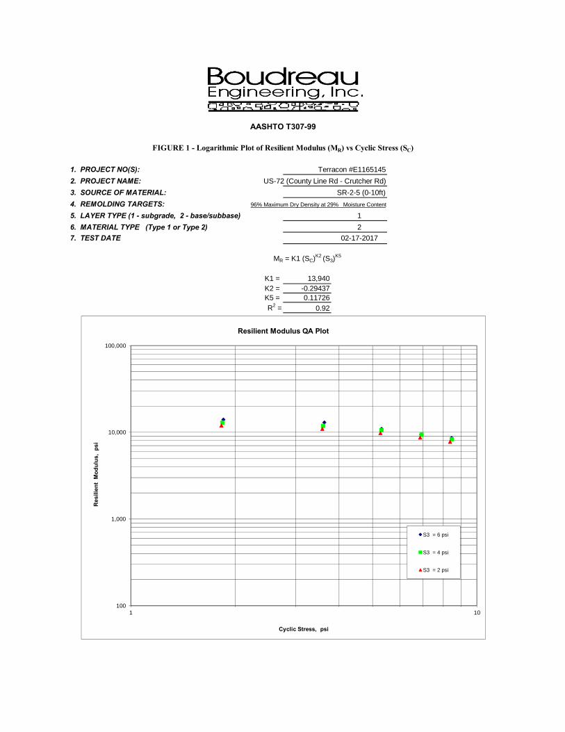
MR = K1 (SC)K2 (S3)K5
K1 = 13,940K2 = -0.29437K5 = 0.11726R2 = 0.92
AASHTO T307-99
FIGURE 1 - Logarithmic Plot of Resilient Modulus (MR) vs Cyclic Stress (SC)
100
1,000
10,000
100,000
1 10
Res
ilien
t M
odul
us,
psi
Cyclic Stress, psi
Resilient Modulus QA Plot
S3 = 6 psi
S3 = 4 psi
S3 = 2 psi

1. PROJECT NO(S): Terracon #E11651452. PROJECT NAME: US-72 (County Line Rd - Crutcher Rd)3. SOURCE OF MATERIAL: SR-2-5 (0-10ft)4. REMOLDING TARGETS: 96% Maximum Dry Density at 29% Moisture Content
5. LAYER TYPE (1 - subgrade, 2 - base/subbase) 16. MATERIAL TYPE (Type 1 or Type 2) 27. TEST DATE 02-17-2017
FIGURE 2 - Quick Shear Stress vs Strain
AASHTO T307-99
0
5
10
15
20
25
30
35
0 1 2 3 4 5
Axi
al S
tres
s (p
si)
Axial Strain (%)

APPENDIX C:PAVEMENT DESIGN DATA

Traffic Data SR-2 (US-72)
ADT (2017) 36,163
ADT (2037) 59,257
K 10%
D 70%
TDHV 2%
TADT 3%
SR-2 (US-72) ESALs
ESALs = [C+P]/2*(TADT)*(0.99)*(FDD)*(FLD)*(7,300)
= [36,163 + 59,257]/2*(0.03)*(0.99)*(0.50)*(0.85)*(7,300)= 4,396,202 ESAL Range C/D
Traffic Data County Line Road
ADT (2017) 12,849
ADT (2037) 17,989
TADT 7.6%
County Line Road ESALs
ESALs = [C+P]/2*(TADT)*(0.99)*(FDD)*(FLD)*(7,300)
= [12,849 + 17,989]/2*(0.076)*(0.99)*(0.50)*(0.85)*(7,300)= 3,599,290 ESAL Range C/D

Traffic Data Old Railroad Bed Road
ADT (2017) 10,797
ADT (2037) 15,354
TADT 5.9%
Old Railroad Bed Road ESALs
ESALs = [C+P]/2*(TADT)*(0.99)*(FDD)*(FLD)*(7,300)
= [10,797 + 15,354]/2*(0.059)*(0.99)*(0.50)*(1.00)*(7,300)= 2,787,651 ESAL Range C/D

Boring No.Station
andOffset
Depth(feet)
AASHTOClassification
DryDensity
(pcf)
MoistureContent
%
%Compaction
MR values at 2 psi confining pressure, psiAve.
Seq11 Seq12 Seq13 Seq14 Seq15SR2-5SR2-6
119+00, 25’ RT122+00, 40' LT
0-10 A-7-6 (22) 94.90 25.5 96 11,890 10,891 9,742 8,636 7,755 9,783
AVG 9,783StDev 1,666
AVG - 2xStDev 6,452AVG + 2xStDev 13,114
Design MR 9,800
MR Calculation Summary Notes:Tests performed at Boudreau Engineering on 2/17/2017
City of Huntsville71-16-TI06Additional Lanes on SR-2 (US-72) FromWest of County Line Road To CrutcherRoad and on County Line Road and OldRailroad Bed RoadGrade, Drain, Base, Pave, Signing, andSignalsMadison and Limestone Counties

Page 1
1993 AASHTO Pavement Design
DARWin Pavement Design and Analysis SystemA Proprietary AASHTOWareComputer Software Product
Flexible Structural Design ModuleCounty Line RoadPlane and Retain
Flexible Structural Design
18-kip ESALs Over Initial Performance Period 2,162,735Initial Serviceability 4.2Terminal Serviceability 3Reliability Level 85 %Overall Standard Deviation 0.49Roadbed Soil Resilient Modulus 9,800 psiStage Construction 3
Calculated Design Structural Number 4.23 in
Rigorous ESAL Calculation
Performance Period (years) 12Two-Way Traffic (ADT) 12,849Number of Lanes in Design Direction 2Percent of All Trucks in Design Lane 85 %Percent Trucks in Design Direction 50 %
VehicleClass
Percentof
ADT
Annual%
Growth
Average InitialTruck Factor
(ESALs/Truck)
Annual %Growth in
TruckFactor
Accumulated18-kip ESALs
over PerformancePeriod
2 92.4 1.7 0.0002 0 4,8615 7.6 1.7 1.0794 0 2,157,874
Total 100 - - - 2,162,735
Growth Compound
Total Calculated Cumulative ESALs 2,162,735
Specified Layer Design
Layer Material Description
StructCoef.(Ai)
DrainCoef.(Mi)
Thickness(Di)(in)
Width(ft)
CalculatedSN (in)
1 Wearing Surface 165 #/sy 0.54 1 1.49 12 0.802 Upper Binder 255 #/sy 0.54 1 2.3 12 1.243 Existing Asphalt (After Milling) 0.44 1 3.5 12 1.544 Existing Crushed Aggregate Base 0.14 1.01 5 12 0.71

Page 2
Layer Material Description
StructCoef.(Ai)
DrainCoef.(Mi)
Thickness(Di)(in)
Width(ft)
CalculatedSN (in)
Total - - - 12.29 - 4.29

Page 1
1993 AASHTO Pavement Design
DARWin Pavement Design and Analysis SystemA Proprietary AASHTOWareComputer Software Product
Flexible Structural Design ModuleCounty Line Road
Widening
Flexible Structural Design
18-kip ESALs Over Initial Performance Period 2,162,735Initial Serviceability 4.2Terminal Serviceability 3Reliability Level 90 %Overall Standard Deviation 0.49Roadbed Soil Resilient Modulus 9,800 psiStage Construction 3
Calculated Design Structural Number 4.39 in
Rigorous ESAL Calculation
Performance Period (years) 12Two-Way Traffic (ADT) 12,849Number of Lanes in Design Direction 2Percent of All Trucks in Design Lane 85 %Percent Trucks in Design Direction 50 %
VehicleClass
Percentof
ADT
Annual%
Growth
Average InitialTruck Factor
(ESALs/Truck)
Annual %Growth in
TruckFactor
Accumulated18-kip ESALs
over PerformancePeriod
2 92.4 1.7 0.0002 0 4,8615 7.6 1.7 1.0794 0 2,157,874
Total 100 - - - 2,162,735
Growth Compound
Total Calculated Cumulative ESALs 2,162,735
Specified Layer Design
Layer Material Description
StructCoef.(Ai)
DrainCoef.(Mi)
Thickness(Di)(in)
Width(ft)
CalculatedSN (in)
1 Wearing Surface 165 #/sy 0.54 1 1.49 12 0.802 Upper Binder 255 #/sy 0.54 1 2.3 12 1.243 Lower Binder 310 #/sy 0.54 1 2.79 12 1.514 Crushed Aggregate Base 0.14 1.01 6 12 0.85

Page 2
Layer Material Description
StructCoef.(Ai)
DrainCoef.(Mi)
Thickness(Di)(in)
Width(ft)
CalculatedSN (in)
Total - - - 12.58 - 4.40
Page 1
1993 AASHTO Pavement Design
DARWin Pavement Design and Analysis SystemA Proprietary AASHTOWareComputer Software Product
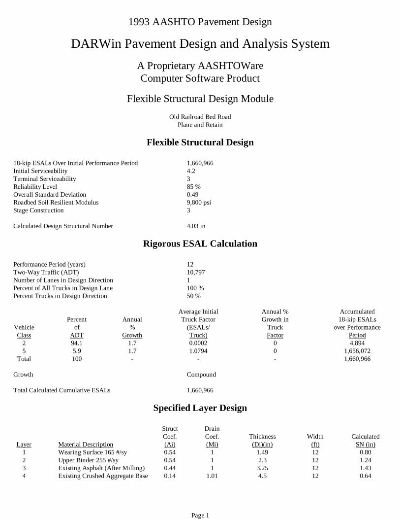
Flexible Structural Design ModuleOld Railroad Bed Road
Plane and Retain
Flexible Structural Design
18-kip ESALs Over Initial Performance Period 1,660,966Initial Serviceability 4.2Terminal Serviceability 3Reliability Level 85 %Overall Standard Deviation 0.49Roadbed Soil Resilient Modulus 9,800 psiStage Construction 3
Calculated Design Structural Number 4.03 in
Rigorous ESAL Calculation
Performance Period (years) 12Two-Way Traffic (ADT) 10,797Number of Lanes in Design Direction 1Percent of All Trucks in Design Lane 100 %Percent Trucks in Design Direction 50 %
VehicleClass
Percentof
ADT
Annual%
Growth
Average InitialTruck Factor
(ESALs/Truck)
Annual %Growth in
TruckFactor
Accumulated18-kip ESALs
over PerformancePeriod
2 94.1 1.7 0.0002 0 4,8945 5.9 1.7 1.0794 0 1,656,072
Total 100 - - - 1,660,966
Growth Compound
Total Calculated Cumulative ESALs 1,660,966
Specified Layer Design
Layer Material Description
StructCoef.(Ai)
DrainCoef.(Mi)
Thickness(Di)(in)
Width(ft)
CalculatedSN (in)
1 Wearing Surface 165 #/sy 0.54 1 1.49 12 0.802 Upper Binder 255 #/sy 0.54 1 2.3 12 1.243 Existing Asphalt (After Milling) 0.44 1 3.25 12 1.434 Existing Crushed Aggregate Base 0.14 1.01 4.5 12 0.64

Page 2
Layer Material Description
StructCoef.(Ai)
DrainCoef.(Mi)
Thickness(Di)(in)
Width(ft)
CalculatedSN (in)
Total - - - 11.54 - 4.11

Page 1
1993 AASHTO Pavement Design
DARWin Pavement Design and Analysis SystemA Proprietary AASHTOWareComputer Software Product
Flexible Structural Design ModuleOld Railroad Bed Road
Widening
Flexible Structural Design
18-kip ESALs Over Initial Performance Period 1,660,966Initial Serviceability 4.2Terminal Serviceability 3Reliability Level 90 %Overall Standard Deviation 0.49Roadbed Soil Resilient Modulus 9,800 psiStage Construction 3
Calculated Design Structural Number 4.20 in
Rigorous ESAL Calculation
Performance Period (years) 12Two-Way Traffic (ADT) 10,797Number of Lanes in Design Direction 1Percent of All Trucks in Design Lane 100 %Percent Trucks in Design Direction 50 %
VehicleClass
Percentof
ADT
Annual%
Growth
Average InitialTruck Factor
(ESALs/Truck)
Annual %Growth in
TruckFactor
Accumulated18-kip ESALs
over PerformancePeriod
2 94.1 1.7 0.0002 0 4,8945 5.9 1.7 1.0794 0 1,656,072
Total 100 - - - 1,660,966
Growth Compound
Total Calculated Cumulative ESALs 1,660,966
Specified Layer Design
Layer Material Description
StructCoef.(Ai)
DrainCoef.(Mi)
Thickness(Di)(in)
Width(ft)
CalculatedSN (in)
1 Wearing Surface 165 #/sy 0.54 1 1.49 - 0.802 Upper Binder 255 #/sy 0.54 1 2.3 - 1.243 Lower Binder 275 #/sy 0.54 1 2.48 - 1.344 Crushed Aggregate Base 0.14 1.01 6 - 0.85

Page 2
Layer Material Description
StructCoef.(Ai)
DrainCoef.(Mi)
Thickness(Di)(in)
Width(ft)
CalculatedSN (in)
Total - - - 12.27 - 4.23


DESCRIPTIONLEGEND NO.
IN PLACE MATERIALS LEGEND
IN PLACE PAVEMENT (RETAIN AND MILL AS REQUIRED)B
NO
SHEET
1
2467
2.5% OR e
6.8
1"
1
6"
6"
24"
8%
8%
1
246A7
2.5% OR e
6.5
8"
1
6"
6"
24"
8%
8%
1
246B7
2.5% OR e
6.2
7"
1
6"
6"
24"
8%
8%
DETAIL A
SR-2 (US-72)
TYPE C C&G
DETAIL D
OLD RAILROAD BED RD
TYPE C C&G
DETAIL C
COUNTY LINE RD
TYPE C C&G
DESCRIPTIONITEM NO.LEGEND NO.
REQUIRED MATERIALS LEGEND
301A-012
1
4
7
424B-681
2 424A-360
424B-651
6
REQUIRED CRUSHED AGGREGATE BASE COURSE, TYPE B, PLANT MIXED 6" COMPACTED THICKNESS
408A-051 REQUIRED PLANING EXISTING PAVEMENT (APPROXIMATELY 0.00" THRU 1.0" THICK) (ACTUAL DEPTH 0.5")
REQUIRED SUPERPAVE BITUMINOUS CONCRETE WEARING SURFACE LAYER,•" MAXIMUM AGGREGATE SIZE MIX, ESAL RANGE C/D (APPROXIMATELY 165 LBS/YD2)
REQUIRED SUPERPAVE BITUMINOUS CONCRETE UPPER BINDER LAYER, 1" MAXIMUM AGGREGATE SIZE MIX, ESAL RANGE C/D (APPROXIAMATELY 255 LBS/YD2)
REQUIRED SUPERPAVE BITUMINOUS CONCRETE LOWER BINDER LAYER, 1" MAXIMUM AGGREGATE SIZE MIX, ESAL RANGE C/D (APPROXIAMATELY 335 LBS/YD2)
6A 424B-681 REQUIRED SUPERPAVE BITUMINOUS CONCRETE LOWER BINDER LAYER, 1" MAXIMUM AGGREGATE SIZE MIX, ESAL RANGE C/D (APPROXIAMATELY 335 LBS/YD2)
6B 424B-681 REQUIRED SUPERPAVE BITUMINOUS CONCRETE LOWER BINDER LAYER, 1" MAXIMUM AGGREGATE SIZE MIX, ESAL RANGE C/D (APPROXIAMATELY 335 LBS/YD2)
6"
1
1
8"VARIES8"
SLOPE VARIES
DETAIL B
2467
6.8
1"
14"
2
14"
SR-2 (US-72)
W/ RAISED MEDIAN
TYPE N CURB
11
14
13
o r
9
10
9
10
650A-000
654A-001
210A-000
210D-001 REQUIRED BORROW EXCAVATION (LOOSE TRUCKBED MEASUREMENT)
REQUIRED SOLID SODDING (BERMUDA)
OR
REQUIRED UNCLASSIFIED EXCAVATION
REQUIRED TOPSOIL (APPROXIMATELY 4" THICK)
11
13 623B-000
14 614A-000
CONCRETE CURB, TYPE N
SLOPE PAVING (4" THICK)
13
ROUTESHEET TITLE
PROJECT NO
REFERENCE
YEAR
FISCAL
NO
SHEET
2017
(US 72)
SR-2
71-16-TI06
CITY OF HUNTSVILLE
:
EXISTING GROUND
DIAMETER + 7'
B
16
2' 2'
1.5' 1.5'
INSIDE
DIAMETER
SAW CUT DETAIL
BA
EXCAVATION
STRUCTURE
16 305B-077 CRUSHED AGGREGATE, SECTION 825, FOR MISCELLANEOUS USE
A IN PLACE PAVEMENT (REMOVE)
DETAILS
DETAILS

APPENDIX D:SOIL BORING DATA


APPENDIX E:PAY ITEM LIST

List of Pay Items
Hot Mix Asphalt424A-360 – Superpave Bituminous Concrete Wearing Surface, ½ inch MaximumAggregate Size Mix, ESAL Range C/D – per ton
424B-651 – Superpave Bituminous Concrete Upper Binder Layer, 1 inch MaximumAggregate Size Mix, ESAL Range C/D – per ton
424B-659 – Superpave Bituminous Concrete Upper Binder Layer, Leveling, 1 inchMaximum Aggregate Size Mix, ESAL Range C/D
424B-681 – Superpave Bituminous Concrete Lower Binder Layer, 1 inch MaximumAggregate Size Mix, ESAL Range C/D – per ton
424B-685 – Superpave Bituminous Concrete Lower Binder Layer, Patching, 1 inchMaximum Aggregate Size Mix, ESAL Range C/D – per ton
401A-000 – Bituminous Treatment A – per square yard 405A-000 – Tack Coat – per gallon
407B-000 – Joint Sealant for Hot Mix Asphalt Pavement – per mile
Earthwork 210A-000 – Unclassified Excavation – per cubic yard 210D-000 – Borrow Excavation– per cubic yard
Graded Aggregate Base301A-006 – Crushed Aggregate Base Course, Type B, Plant Mixed, 4.5” CompactedThickness – per square yard
301A-012 – Crushed Aggregate Base Course, Type B, Plant Mixed, 6” CompactedThickness – per square yard
430B-043 – Aggregate Surfacing (1” Down, Crusher Run) – per ton
Miscellaneous408A-051 – Planing Existing Pavement (Approximately 0.00” through 1.0” Thick) – persquare yard
408A-052 – Planing Existing Pavement (Approximately 1.10” through 2.0” Thick) – persquare yard
410H-000 – Material Remixing Device – each605A-000 – Topsoil – per cubic yard618B-003 – Concrete Driveway, 6” thick (Includes Wire Mesh) – per square yard