Socio-economic impact assessment - Home - Roads … socio-economic assessment takes into account the...
42
Appendix M Socio-economic impact assessment
Transcript of Socio-economic impact assessment - Home - Roads … socio-economic assessment takes into account the...

Appendix M
Socio-economic impact assessment


Roads and Traffic Authority
Report for Third Crossing of the Hunter River
Socio-economic Impact Assessment
November 2006

21/14359/124141 Third Crossing of the Hunter River Socio-economic Impact Assessment
Contents
Executive summary 5
1. Introduction 7
1.1 Overview 7 1.2 Scope and Methodology 7 1.3 Relevant legislation 9
2. Existing socio-economic setting 10
2.1 Locational context 10 2.2 Socio-economic setting of area directly affected by the Proposal 10
3. Proposal description and assumptions 13
3.1 Summary of Proposal 13 3.2 Community issues and concerns 14
4. Potential socio-economic impacts 16
4.1 Noise impacts 17 4.2 Visual impacts 18 4.3 Air quality impacts 19 4.4 Land use and property impacts 19 4.5 Accessibility impacts 20 4.6 Community cohesion/severance impacts 21 4.7 Wellbeing impacts 22 4.8 Economic impacts 23
5. Conclusion 28
6. References 29
Population 31 Age profile 31 Housing and accommodation 33 Place of birth and ethnicity 33 Indigenous persons 33 Community facilities and services 33 Economic profile 34 Workforce, income and education 35

21/14359/124141 Third Crossing of the Hunter River Socio-economic Impact Assessment
Regional resources 35 Commercial Activity 38 Retail 38 Tourism 38 Land use and transport 39
Table Index Table 1 Summary of Approach 8 Table 2 Population of affected communities 31 Table 3 Age Distribution in the Maitland LGA 1996-2001 32 Table 4 Maitland Population and Growth (% change
between reported years) 35 Table 5 Value of agricultural production across major
industries 36 Table 6 The origin of visitors to cultural activities in Maitland 39
Figure Index Figure 1 Area likely to be affected by the Proposal 12 Figure 2 East Maitland Traffic Management Proposal 14 Figure 3 NSW coal production, 1995/96 to 2001/02 37 Figure 4 Australian mining industry summary statistics 37
Appendices A Socio-demographic and economic profile

5
21/14359/124141 Third Crossing of the Hunter River : 14 November 2006 Socio-economic Impact Assessment
Executive summary
The development of the proposed third crossing of the Hunter River has a number of potential impacts on various community levels, including the broader community, the regional community, the local community and individuals affected by the proposal. The Proposal is located within the Maitland local government area. Maitland is a major regional administrative centre, with an estimated population of 60,000 persons at the 2001 Census. It is characterised by dispersed settlement patterns separated by low lying flood plains and transport lines. The area directly affected by the Proposal route comprises a number of discrete urban settlements as well as rural/agricultural, industrial and commercial development.
The Proposal involves a third crossing of the Hunter River between the existing crossings at Maitland (Belmore Bridge) and Morpeth. Its objectives are to improve accessibility in Maitland, alleviate traffic congestion on the Belmore Bridge, and provide an alternative crossing to the Morpeth Bridge, which requires periodic maintenance.
The socio-economic assessment takes into account the likely and potential impact of the Proposal on socio-economic activities, property, public and private amenity, severance, wellbeing effects and economic impacts. A number of these issues were raised in community consultation regarding the choice of route, and in relation to possible impacts arising from the preferred route itself.
There are anticipated to be a number of positive social and economic impacts resulting from the Proposal:
Travel times will be reduced and traffic flows improved;
Traffic congestion in the vicinity of the Belmore Bridge and Morpeth Bridge will be reduced to the benefit of Central Maitland and Morpeth;
Accessibility will be improved for communities located to the north of the Hunter River, promoting social cohesion between these communities and those to the south of the river;
Business activity is expected to benefit, particularly in East Maitland;
The Proposal is expected to enhance employment opportunities in this area.
The impacts that are likely to be detrimental to areas along the Proposal route include:
Noise;
Visual amenity;
Loss of prime agricultural land; and
Severance of land holdings.
The alignment of the route has sought to minimise the effect of these detrimental impacts. In addition, further mitigation measures have been outlined to reduce the effect of such impacts on specific sites and sections of the local community.

6
21/14359/124141 Third Crossing of the Hunter River : 14 November 2006 Socio-economic Impact Assessment
Overall, the socio-economic benefits of the Proposal significantly outweigh the detrimental impacts, which can be further minimised through effective mitigation measures.
The implementation of the proposed mitigation measures contained herein support progression of the Proposal.

7
21/14359/124141 Third Crossing of the Hunter River : 14 November 2006 Socio-economic Impact Assessment
1. Introduction
1.1 Overview The NSW Roads and Traffic Authority (RTA) proposes to construct a third crossing of the Hunter River near Maitland (referred to as ‘the Proposal’ for the purposes of this report). The new crossing is required to relieve congestion and maintenance work on the existing crossings of the Hunter River – Belmore and Morpeth Bridges. These bridges currently provide direct connectivity between Maitland and the rural residential areas to the north, as well as Paterson and Dungog.
GHD has been engaged to undertake a socio-economic assessment of the Proposal. This report assesses the potential social impacts of the proposed third crossing of the Hunter River near Maitland. It describes the characteristics of the communities indirectly and directly affected by the Proposal, types of issues and concerns expressed by community members and likely socio-economic impacts that could be associated with this development.
1.2 Scope and Methodology
1.2.1 Scope
The focus of this report is on social and economic impacts – direct or indirect, perceived or actual and on the various affected community groups.
This Socio-economic Impact Assessment (SIA) is prepared with respect to the Proposal and addresses relevant requirements under Section 111 (Part 5) of the Environmental Planning and Assessment Act, 1979.
1.2.2 Approach to Analysis
Assessment of social impacts considers the changes caused by a proposed development on the human dimensions of the environment. It considers the potential costs, risks and benefits on people and their communities and allows for alternatives and mitigation measures to be considered.
Social impacts are generally defined as:
“changes to individuals and communities due to a proposed action that alters the way in which people live, work, play, relate to one another, organize to meet their needs and generally cope as members of society” (Burge, 2005).
Social impacts may be direct or indirect and may have varying consequences for:
Individuals (such as their the way of life);
Community (such as its cohesion, character, services and facilities); and
Culture (such as its beliefs, customs and values) (IAIA, 2003).

8
21/14359/124141 Third Crossing of the Hunter River : 14 November 2006 Socio-economic Impact Assessment
This SIA examines the potential social impacts on the affected communities that may result from the implementation of the Proposal. This includes the changes to the social character, workings and environment of the locality and associated communities. This report does not assess the economic impacts in quantitative terms, however references to socio-economic conditions such as employment, business and economic activities have been included.
The approach adopted for assessment is comprised of the stages listed in Table 1.
Table 1 Summary of Approach
Existing socio-economic setting
Analysis of the existing socio-economic environment in the vicinity of the proposed development to identify a baseline of social and economic characteristics and issues.
Proposed development summary
Summary of the proposed development, assumptions and outline of community issues and concern. This allows for assumptions to be identified and expressed community sentiment to be incorporated into the analysis of socio-economic issues.
Identification and evaluation of socio-economic impacts
Analysis of the positive and negative potential socio-economic impacts on the social environment and locality in both the short and long term.
Proposed mitigation measures
Outline of proposed mitigation measures to be considered to mitigate the extent of socio-economic impacts identified in the above.
The main sources of information from which this SIA is based are:
Information provided by the RTA’s Environmental Officer, Paula Crighton;
Discussions with Chris James (Manager Assets and Infrastructure Planning), Leanne Harris (Manager Strategic Services) and Roger Stephen (Economic Development and Marketing) Maitland City Council;
Discussions with Joy Duncan, Manager, and Susan Westcott, Environmental Officer, Environmental Planning and Assessment Branch, RTA;
Relevant reports and studies (see reference list at Section 6); and
Visits to the site and its locality.
1.2.3 Structure of this Report
This report first characterises the existing socio-economic setting in the area of and immediately surrounding the Proposal. Issues raised by stakeholders during previous consultation activities are then summarised.
The Proposal’s key features are described.
Potential socio-economic impacts are then discussed in relation to the potential impacts on amenity, land use and property, accessibility, community cohesion /

9
21/14359/124141 Third Crossing of the Hunter River : 14 November 2006 Socio-economic Impact Assessment
severance, health and the economy. For each impact, a mitigating measure is recommended.
The report concludes with recommendations, including the changes that should be incorporated into the Proposal to minimise potential adverse social impacts.
1.3 Relevant legislation The provisions of the Environmental Planning and Assessment Act 1979 (EP&A Act) and the Environmental Planning and Assessment Regulation 2000 are relevant to this project.
1.3.1 Environmental Planning and Assessment Act 1979
The EP&A Act forms the statutory basis for planning and environmental assessment in NSW. A primary objective of this Act is:
“to encourage the proper management, development and conservation of natural and artificial resources, including agricultural land, natural areas, forest, minerals, water, cities, towns and villages for the purpose of promoting the social and economic welfare of the community and a better environment”.
The RTA is required to assess the impacts of the Proposal under Section 111. This section of the Act states that:
(1) For the purpose of attaining the objects of this Act relating to the protection and enhancement of the environment, a determining authority in its consideration of an activity shall, notwithstanding any other provisions of this Act or the provisions of any other Act or of any instrument made under this or any other Act, examine and take into account to the fullest extent possible all matters affecting or likely to affect the environment by reason of that activity.
The socio-economic assessment report will be written to ensure all socio-economic issues are considered and incorporated into the Proposal.
1.3.2 Environmental Planning and Assessment Regulation 2000
Clause 228 of the Environmental Planning and Assessment Regulation requires consideration to be given to factors concerning the impact of an activity on the environment.
The factors to be considered include impacts on communities, ecosystems, aesthetics, protected habitats or species, risks to safety of the environment, transformations to a locality, effects on localities with special value, and any degradation to the quality of the environment.
To address these requirements, the RTA has commissioned GHD to prepare a SIA as an input to a Review of Environmental Factors (REF) being prepared for the project.

10
21/14359/124141 Third Crossing of the Hunter River : 14 November 2006 Socio-economic Impact Assessment
2. Existing socio-economic setting
2.1 Locational context The study area is located in the Hunter Region of NSW within the Maitland Local Government Area (LGA). The Lower Hunter Region comprises the LGAs of Maitland, Cessnock, Port Stephens, Newcastle and Lake Macquarie and 84% of the Hunter Region population. Characteristics of importance to the Hunter Region are vineyards, heritage and national parks, as well as mining, agriculture and tourism industries.
Maitland LGA is located 150km from Sydney and extends across the floodplains of the Hunter and Paterson Rivers. It is located in close proximity to major transport links including road and rail, coastal areas of the Hunter and the industrial and commercial centres of Newcastle and Sydney. It has an estimated population of 59,949 people (HVRF, 2004) and is projected to continue to experience strong population growth.
Maitland acts as a major regional administrative centre providing a range of government, health and higher educational facilities.
Maitland LGA is characterised by dispersed development patterns separated by low-lying floodplains and transport lines. The main urban centres are Maitland/East Maitland, Rutherford, Metford, Thornton and Woodberry, which are located to the south of the Hunter River.
The Maitland area has long been recognised as being rich in natural resources such as coal, agriculture, (particularly dairy cattle and horticulture), and other mineral deposits and metals. Major industries in the LGA include pharmaceutical, transport, mining and engineering, light commercial, industrial businesses, vineyards and tourism. Maitland was developed as a prominent commercial and administrative centre in the nineteenth century. Accordingly, many items of state and local heritage significance which have survived from this period of initial development, are important to defining its intrinsic sense of place which, in turn, is important to the local community and the local tourism industry.
2.2 Socio-economic setting of area directly affected by the Proposal
The area likely to be affected by the Proposal (see Figure 1) comprises a number of discrete urban settlements as well as rural/agricultural, industrial and commercial development. The key community structure characteristics of this area are as follows:
Bolwarra, Bolwarra Heights and Largs: These villages are located to the north of the Proposal. The villages are established residential areas serving a combined population of 3,126 people (MCC, 2003).
East Maitland and Pitnacree: Pockets of small business operate along and at the end of the Proposal at East Maitland. East Maitland is a densely populated residential area of 10,944 persons (including Raworth and Tenambit) and has a number of schools, parks, community facilities and social housing. Pitnacree is a small discrete residential

11
21/14359/124141 Third Crossing of the Hunter River : 14 November 2006 Socio-economic Impact Assessment
settlement to the north of the Main Northern Railway. The population of East Maitland is primarily made up of middle-income households, with a proportion of low-income earners.
Central Maitland, South Maitland and Lorn: Although not located along the Proposal route, Maitland is one of the main business centres in the LGA. It has some residential development, predominantly at Lorn and South Maitland. Together these villages have a population of 3,940 people (MCC, 2003).
Morpeth: Morpeth has an established population of 938 people (MCC, 2003). The village has a long history associated with the Hunter River and is recognised for its heritage character, Morpeth Bridge and as a tourist destination. Morpeth is not located along the Proposal route but is likely to be affected.
Industrial/commercial development: There is some industrial and commercial development at East Maitland.
Rural/agricultural development: Rural and agricultural enterprises are located to the north and south of the Hunter River in the immediate vicinity of the Proposal. This is prime agricultural land on the central floodplain. Agricultural uses include turf farms (concentrated on Flat Road), vegetable growing and livestock grazing, and rural dwellings and outbuildings associated with these uses. There are approximately 17 agricultural properties located along the length of the Proposal.
Heritage items in close proximity to the Proposal route include the East Maitland Heritage Conservation Area, three residences on Pitnacree Road, Pitnacree, the Pender and Forster Sawmill at Pitnacree, and the Bolwarra Heritage Conservation Area. These items will not be significantly affected by the Proposal.
Most land holdings affected by the Proposal are in private ownership. At the southern end there are some parcels of Crown land, Council land, and a number of commercial and industrial properties. Some of these land holdings are substantial in area.
There is predicted to be limited growth in the immediate vicinity of the Proposal as a result of the land’s zoning for agricultural use and being largely subject to flooding. Maitland City Council has not identified any investigation areas for future urban settlement in the vicinity of the Proposal route.

12
21/14359/124141 Third Crossing of the Hunter River : 14 November 2006 Socio-economic Impact Assessment
Figure 1 Area likely to be affected by the Proposal

13
21/14359/124141 Third Crossing of the Hunter River : 14 November 2006 Socio-economic Impact Assessment
3. Proposal description and assumptions
3.1 Summary of Proposal The RTA proposes to construct a third crossing of the Hunter River near Maitland. The proposed crossing of the Hunter River north of Maitland would help improve accessibility in Maitland, reduce traffic congestion at the Belmore Bridge and provide an alternative crossing to the Morpeth Bridge.
The objectives of the Proposal are:
To improve accessibility in Maitland;
To alleviate traffic congestion on the Belmore Bridge;
To provide an alternative crossing to the heritage listed Morpeth Bridge, which is subject to temporary load restrictions and ongoing maintenance.
The Proposal would stretch between the intersection of Melbourne and Lawes Streets, East Maitland along Pitnacree Road and then north across the Hunter River to join with Glenarvon Road. The Proposal includes traffic management works at Pitnacree Road, Melbourne Street, Lawes Street and the New England Highway (see Figure 2). Upgrading works are proposed on both Glenarvon Road to Largs and Flat Road to Bolwarra. Works are also proposed at the intersection of Melbourne Street and Newcastle Road in East Maitland.
The proposed crossing would be a two lane road and bridge with a shared shoulder/cycleway. It would be constructed to a local road standard with limited earthworks to minimise impact on the Lower Hunter River Flood Mitigation Scheme and accordingly would not be flood free.
According to the Route Options Development Report, (RTA 2004), the key attributes of the Proposal are:
25% reduction in traffic on Belmore Bridge;
35% reduction in traffic on Morpeth Bridge;
5% increase in traffic on Melbourne Street north of the New England Highway;
54% increase in traffic on Lawes Street;
7% reduction in traffic on the New England Highway west of Melbourne Street;
Total distance savings per day is would be 10,500km; and
Total travel savings per day would be 720 hours.
The construction period is expected to last for approximately two years.

14
21/14359/124141 Third Crossing of the Hunter River : 14 November 2006 Socio-economic Impact Assessment
Figure 2 East Maitland Traffic Management Proposal
3.2 Community issues and concerns The following issues were raised by stakeholders during previous consultation activities and may be relevant to the current study:
Much of the land in the study area is Class 1 agricultural land i.e. land with the highest productivity in NSW (RTA 2004).
The Proposal would remove some traffic from the Belmore Bridge (in Maitland) which may have an economic impact on businesses in Maitland;
The Proposal may increase the number of cars that travel down Lawes Street and therefore increase traffic noise;
The Proposal would sever existing practising agricultural properties north and south of the Hunter River.

15
21/14359/124141 Third Crossing of the Hunter River : 14 November 2006 Socio-economic Impact Assessment
Upon assessment of the route options, a modified version of Eastern Route Option 1 (ER1) was selected as the Preferred option. The route was modified in response to the concerns raised during community consultation regarding pedestrian safety and intersection performance at the Cumberland Street roundabout. The modification was also intended to minimise traffic increases through the Melbourne Street railway underpass; further reduce agricultural land take; and avoid a new crossing of the floodway immediately north of Morpeth Road.
Maitland City Council and members of the community also identified current network performance and peak period congestion at the intersection of Melbourne Street and the New England Highway as critical issues. Although the Route Options Development Report found the impact on the performance of the intersection would be minimal, it recommends that traffic management measures in East Maitland need to be developed.
There is also opposition to the Proposal from residents of Pitnacree village and some farmers affected by the Proposal. Issues raised by local action group relating to the Proposal include:
Farmers’ livelihood will be dramatically affected;
Heritage impact on one of the oldest areas of Maitland (Melbourne Street and Pitnacree);
Traffic impacts caused by installation of traffic lights at the intersection of Pitnacree, Melbourne Street and Lawes Streets (see Figure 2);
Overhead rail bridge at Pitnacree is far too dangerous (camber angle) and only half the width of the overhead rail bridge in West Maitland; and
Dispersal of heavy volumes of traffic through suburban streets in East Maitland is far too dangerous.

16
21/14359/124141 Third Crossing of the Hunter River : 14 November 2006 Socio-economic Impact Assessment
4. Potential socio-economic impacts
Changes to a road network caused by constructing a major new road can have both positive and negative effects on people at an individual and at a community level. Community groups that may be affected include the existing future road users; businesses; community members living and working in close proximity to the road alignment; and the broader community.
The impacts may be direct or indirect, perceived or actual and vary during construction and operation phases. For the purposes of the assessment, a number of potential issues associated with the socio-economic environment in the study area have been identified. These issues have been identified based on:
Experience in other road construction and upgrading projects;
Knowledge of the specific characteristics of the community within the study area;
Areas of concern raised during community consultations on route options as well as on the preferred option.
The Proposal is anticipated to generate the following impacts, both in the immediate vicinity of the Proposal route and in the wider area:
Amenity (noise, visual and air pollution impacts)
Physical or material comfort offered by the surrounding environment, particularly in places where people reside or gather. With regard to infrastructure projects of this nature, amenity is predominantly affected by noise, visual and air pollution impacts.
Land use and property
Broad land use impacts and property impacts on individual properties.
Accessibility Ease and safety with which people in the community can move both within the community and externally to it. This includes vehicular, pedestrian and cyclist movements.
Community cohesion / severance
The physical or psychological separation or cohesion between different areas in the community or that reinforces an existing severance or brings together that community.
Wellbeing
Changes that may be a source of stress for community members. They generally relate to changes to amenity, disruption to travel, livelihood changes, economic implications and uncertainty.
Economic impacts
Direct and indirect effects on economic and employment factors such as business, tourism and industrial activities.
17
21/14359/124141 Third Crossing of the Hunter River : 14 November 2006 Socio-economic Impact Assessment
4.1 Noise impacts Noise impacts will be experienced in different ways during the construction phase and, later, in the operational phase, once the new route is open to traffic.
4.1.1 Construction phase
Construction of the Proposal will involve site establishment works, earthworks, and road and bridge construction activities.
Over 10,500 truck movements are to be expected in the region during the construction phase. The direction of delivery for trucks would be dependent on the location of the sources of the materials. For works to the south of the Hunter River, access would be via Melbourne Street and Pitnacree Road. For works to the north of the Hunter River access would be via Belmore and Patterson Roads, and Flat and Glenarvon Roads. Materials may also be hauled from the northeast via Morpeth.
It is anticipated that work for the Proposal would be undertaken during standard RTA working hours, that is, 7.00am- 6.00pm Monday to Friday and 7.00am- 1.00pm on Saturdays. For construction work within an audible distance from residences, work will commence at 8.00am on Saturdays. There will be no operational work on Sundays. Proposed works on Melbourne Street may require works outside of standard hours.
These works are likely to generate short term noise impacts along the length of the Proposal route. Given the nature of road construction, however, equipment will not be situated close to residences along the route for extended periods.
There are a number of activities regarding bridge works that will occur and that are likely to have short term detrimental noise impacts. The use of construction equipment is also likely to generate local noise impacts.
Recommended mitigation measures include1:
Preparation of a noise management plan prior to construction commencing to ensure that all employees understand and take responsibility for noise control at sites along the route;
Issuing of regular community updates regarding progress of the project;
Informing affected residents in advance regarding the extent and timing of potentially noisy construction activities, and advising when noise levels during such works may be relatively high;
Undertaking monitoring of plant identified as being excessively noisy. Where such plant emissions exceed their rated sound levels, the contractor should be instructed to modify the equipment accordingly or remove it from the site;
Providing contact details for which the public may seek information or make a complaint. A log of complaints is to be maintained and resolved in a responsive manner by the site supervisor;
1 See ERM Australia Third Hunter River Crossing Near Maitland November 2006: 37

18
21/14359/124141 Third Crossing of the Hunter River : 14 November 2006 Socio-economic Impact Assessment
Temporary noise abatement measures e.g. screening at selected localities along the route, be provided as necessary;
Adherence to approved hours of operation. For work outside of standard working hours, the procedure contained in the RTA’s Environmental Noise Management Manual 2001, “Practice Note vii – Roadworks Outside of Normal Working Hours” is to be followed.
4.1.2 Operational phase
Based on noise modelling of the predicted noise levels along the route, indications are that there would be marginally higher noise levels in the vicinity of Melbourne Street at the intersection of Lawes Street and Pitnacree Road. These noise levels are, however, within accepted levels.
Noise levels along the route to the north of Pitnacree village, and on the northern side of the river along Glenarvon and Flat Roads, are expected to exceed acceptable levels. Receivers in this area will be single and isolated residences.
Recommended mitigation measures include:
Architectural treatment of affected residences where feasible and reasonable to provide an acceptable solution to noise impacts along the route.
4.2 Visual impacts The study on Visual Assessment prepared by Geolink, July 2006, assessed 33 viewing sections of which nine were deemed potentially to have a high visual impact if works were to proceed. These sections are:
Pitnacree Road, north of railway crossing with view taking in southern extent of new road around sawmill;
Pitnacree Road with view taking in northern extent of new road around sawmill;
Pitnacree Road with view taking in new road across private rural property to south side of bridge;
Hunter River south bank with view taking in new road across private rural property to the south side of bridge and the new bridge;
Hunter River north bank with view taking in new road across private rural property to the north side of bridge and the new bridge;
Glenarvon Road, 500m north of bridge site with view taking in new road across private rural property to north side of bridge;
Glenarvon Road, 180m southwest of Flat Road intersection with view taking in southern extent of new road linking Flat and Glenarvon Roads;
Flat Road, 350m west of Glenarvon Road intersection with view taking in northern extent of new road linking Flat and Glenarvon Roads.
These locations all have views to new roads located where previously there was no road and bridge. The visual impacts relate to the new road dividing the existing rural

19
21/14359/124141 Third Crossing of the Hunter River : 14 November 2006 Socio-economic Impact Assessment
scenery, detracting from the visual amenity of the existing rural landscape and detracting from the existing high visual amenity of the area. The bridge will provide a distinctive addition to the rural landscape and will appear larger in scale relative to the surrounding terrain.
Short term impacts include the visual impact of road closures, machinery, work crew and signage lasting the duration of the construction phase.
Recommended mitigation measures include2:
Provide smooth earth batters to maximise integration of roadworks with the adjacent landscape;
Grass seed earth batters to promote quick ground cover and facilitate earthworks blending in with adjacent grassland;
Minimise vertical infrastructure to the road to limit the number of built elements that can be seen with the otherwise rural setting;
Provide fences to the edge of the road that reflect the visual character of rural fences in the surrounding area e.g. timber post and wire;
Use materials and forms that reflect the visual character of existing roads in the area.
4.3 Air quality impacts Air quality impacts are likely to arise during the construction phase of the Proposal.
Local air quality within the vicinity of the proposed route is considered to be good to moderately good, given that it passes through a predominantly agricultural area and at the edge of existing urban settlements.
Construction may result in a larger perceived increase in particulate matter such as dust, and emissions from construction vehicles and equipment. During the operational stage, the generation of particulate matter will be minimal, as the road surface will be sealed.
The recommended mitigation measure is to:
• Develop and implement an appropriate Air Quality Management Plan during the construction stage, which incorporates best management practices to minimise the potential impacts associated with an increase in particulate matter.
4.4 Land use and property impacts The land use impacts are predominantly at a property level. The most notable property impacts will be:
2 Geolink Visual Assessment July 2006: 100-112

20
21/14359/124141 Third Crossing of the Hunter River : 14 November 2006 Socio-economic Impact Assessment
Strip acquisition of agricultural properties along Flat Road, and sections of Glenarvon Road and Pitnacree Road;
Strip acquisition of agricultural properties along the southern section of the Proposal and a section of the Hunter River;
Partial acquisition of the sawmill site at Pitnacree; and
Partial acquisition of Crown land, Council land and some private agricultural land at the southern portion of the proposed road alignment.
Consultation with the local community has identified a concern that the Proposal would sever existing operating agricultural properties to the north and south of the Hunter River and that farmers’ livelihood would be dramatically affected.
Partial and strip acquisition along the length of the proposed road alignment will remove some agricultural land, reduce land holding size, and could impede access to the river frontage of these properties. Land acquisition will have a greater degree of impact on those agricultural properties that have existing dwellings in close proximity to the proposed road alignment.
Overall, the proposed alignment of the road minimises land use changes and property acquisition impacts by using existing road corridors and river levees.
Recommended mitigation measures to minimise impacts include:
Acquisition of property in accordance with the RTA Land Acquisitions Policy and the Land Acquisition (Just Terms Compensation) Act 1991 for land relevant for the construction, operation and maintenance of the Proposal.
4.5 Accessibility impacts Changes to access and egress including safety effects and the creation of alternative linkages for regularly used travel paths can result in social impacts for the local community as they have to change their movement patterns.
4.5.1 Construction phase
During construction, there is likely to be disruption to people’s travelling patterns. Such disruption may include changes to accessibility and road conditions associated with general road construction activities.
Areas that may experience access impacts during construction are:
Flat Road, Pitnacree Road and Glenarvon Road due to road widening and improvement;
The proposed intersections and traffic management works at Melbourne Street, Pitnacree Road and Lawes Street; Melbourne Street and the New England Highway; Flat Road and Paterson Road; Flat Road and Glenarvon Road; and
Rail and river access may also be impacted during construction, particularly during the construction of the river crossing and upgrade to the existing overpass.

21
21/14359/124141 Third Crossing of the Hunter River : 14 November 2006 Socio-economic Impact Assessment
It is likely that road works may impact on agricultural activity and access to residential homes along the route. Congestion may also occur as a result of construction activities at East Maitland.
Recommended mitigation measures include:
Access to properties is to be maintained during construction of the Proposal;
A traffic management plan is to be developed and implemented to minimise potential hazards, risks and confusion arising during construction. This plan is to be advertised to inform the community of proposed changes to traffic movement, and to allow for ongoing operation of the road in a safe manner.
4.5.2 Operational phase
The Proposal will improve accessibility in the region, reduce travel times and improve safety and convenience for travellers between Lorn and Maitland. It will have a positive impact by decreasing congestion (thereby improving access) at Belmore Bridge and Morpeth Bridge.
The most notable concern relating to access impacts of the Proposal are within the Melbourne Street/Lawes Street vicinity. This relates to:
Maintaining access to agricultural holdings to the north of Pitnacree village, including those north of the River;
Potential for traffic congestion, pedestrian safety along Melbourne Street, particularly between Pitnacree Road and the New England Highway; and
Potential for Lawes Street to become a ‘rat run’.
The Proposal has previously been modified to address community concerns relating to peak hour congestion and pedestrian safety at the Cumberland Street roundabout. Relocating the southern connection from Cumberland Street roundabout to the intersection of Melbourne Street and Lawes Street removes the potential conflict of traffic and pedestrians between East Maitland railway station and Grossmann High School. It also avoids increasing traffic at the Melbourne Street railway underpass.
Recommended mitigation measures include:
Resolve fencing and location of access gates to agricultural holdings with local landholders along the route to the north of Pitnacree village;
Development of traffic management measures to address potential for increased traffic congestion and pedestrian safety;
Monitoring of traffic in Lawes Street with a view to implement traffic calming measures, if required.
4.6 Community cohesion/severance impacts Community cohesion and severance relates to the potential of the Proposal to improve connectivity for localities or create physical and psychological barriers between them.

22
21/14359/124141 Third Crossing of the Hunter River : 14 November 2006 Socio-economic Impact Assessment
It is noted that the Proposal will result in improved local and regional connectivity within Maitland LGA and between townships such as Bolwarra, Largs and East Maitland areas. Community cohesion may also be improved in the residential areas of Lorn and Pitnacree as a result of a reduction in traffic volumes on Belmore Road (in the case of Lorn) and Pitnacree Road through the village of Pitnacree.
The local area of the Proposal is currently severed by the Hunter River and existing road networks. The Proposal, by providing additional connectivity between the two parts of the community, is likely to reduce the severance impact of the river and enhance community cohesion.
Community consultation has indicated concern that the Proposal would sever existing operating agricultural properties on either side of the Hunter River. As most sections of the proposed route will be built within the alignment of the existing roads, severance will be minimal.
The sawmill site will retain access to Pitnacree Road.
The proposed new road alignment between Pitnacree and Glenarvon Roads will create severance of three large private property holdings.
Recommended mitigation measures include:
The impact of severance can be minimised by maintaining access to the holdings on either side of this roadway with the installation of appropriate fencing and access gates.
4.7 Wellbeing impacts Wellbeing impacts related to road infrastructure proposals are generally related to amenity and property impacts, disruption to travel patterns and associated livelihood changes, economic implications and uncertainty. Wellbeing impacts related to the social disruption caused by the Proposal are likely to be different depending on the individual circumstances of community members.
At a broader level, wellbeing impacts associated with congestion on the Belmore Bridge and Morpeth Bridge are anticipated to improve. The Proposal represents a positive impact for road users of Belmore and Paterson Roads (Belmore Bridge) and Phoenix Park Road (Morpeth Bridge) as well as improving regional connectivity and cohesion. This has the potential to have subsequent improved health impacts for community members in the region.
The Proposal has the potential to have adverse impacts on wellbeing arising from amenity, access, property and economic impacts (as discussed above). However, the degree of impact will depend on the level of consultation with the affected property owners and the wider community, land acquisition negotiations and the level to which uncertainty is addressed and effective mitigation measures put in place.
Recommended mitigation measures include:
RTA is to maintain ongoing community liaison, keeping local and affected stakeholders informed, through the determination and construction phases.

23
21/14359/124141 Third Crossing of the Hunter River : 14 November 2006 Socio-economic Impact Assessment
4.8 Economic impacts Community feedback relating to the Route Options Development Report noted possible issues related to businesses in Maitland, loss of productive land and severance issues. Consideration of these issues, and review of primary economic impacts shows an overall positive impact of the project on the community and surrounding areas.
Six potential economic impacts have been identified for the Proposal:
Road user impacts;
Business impacts;
Residential growth;
Tourism;
Township amenity; and
Agricultural impacts.
These impacts are detailed below.
4.8.1 Road User Impacts
Current Situation Traffic origin destination figures complied by the RTA suggest that around 14,400 vehicles use the Belmore Bridge each day and 5,700 use the Morpeth bridge on a daily basis. Thus, just over 20,000 vehicles per day cross the Hunter River near Maitland. This traffic is associated with employment, commercial, education and social activities in Maitland.
A summary of the main potential impacts are:
Congestion at the approaches to the bridges;
Congestion in the town centre for commuters travelling in and out of Maitland; and
Delays for those travellers wishing to access the New England Highway going to places such as Thornton, Beresfield and Newcastle.
Proposal Impacts Economic modelling carried out for the Route Options Development Report identified that the project would cost in the order of $37 million with annual maintenance costs of $50,000 per year. Key benefits linked to the Proposal include:
Total distance savings of 10,500km per day;
Travel time savings of 720 hours per day; and
Average time savings per trip of 6.6 minutes.
A benefit cost ratio of 2.4 was found. This indicates that the discounted benefits over the 30 year evaluation period outweigh the discounted costs by over twice as much. Any project over 1.0 is indicative of a socially desirable project.

24
21/14359/124141 Third Crossing of the Hunter River : 14 November 2006 Socio-economic Impact Assessment
4.8.2 Business Impacts
Continued residential growth in the local area will maintain strong demand for retail sales and commercial services in Maitland. The placement of the third river crossing may result in changes to the type of retail and commercial activities carried out in the various centres. However, the net effect of improved accessibility and amenity to the business areas would be expected to ensure a net positive overall effect for the community.
The business growth in Maitland has been high and would be expected to continue, in line with population growth. Local retail centres are currently benefiting from this growth. An example of this is the local Greenhills complex that is reported to be one of the best performing Stockland developments in NSW3. Discussions with the Maitland City Council have identified East Maitland, Central Maitland; and Greenhills centre as the areas most likely to be affected by the Proposal.
There will be positive economic impacts in job creation during construction. It is estimated that up to 100 people will work on the construction of the proposal. There will be flow on effects to local business areas through increased expenditure of this workforce on retail items, accommodation, etc.
East Maitland East Maitland shopping area is located at the southern end of the Proposal and is loosely bounded by George Street, the northern railway, High Street and Lawes Street. It is currently characterised by strip retail, has a large amount of Council parking and is being considered for further expansion. Council is evaluating a concept plan for its future development including improved landscaping, development of footpath areas and inclusion of a small supermarket.
East Maitland can be considered to be suitable as a low congestion alternative for shoppers who want to avoid traffic at the major centres nearby (i.e. Greenhills and Central Maitland). East Maitland is ideally placed to capitalise on traffic movements across the proposed third river crossing for those going to/coming from the areas north of the Hunter River. This increase in through-traffic is likely to boost local economic activity in East Maitland.
An increase in through-traffic is also likely to bring higher traffic flows within East Maitland. Due to modest change in these traffic flows, it is not expected that local business activity will be affected. Local traffic management works in the vicinity of Melbourne Street and the New England Highway is expected to include the removal of some car-parking spaces on Melbourne Street to facilitate traffic movements in this area.
Overall, the Proposal is expected to have a positive impact on business activity in East Maitland.
3 Discussions with Maitland City Council

25
21/14359/124141 Third Crossing of the Hunter River : 14 November 2006 Socio-economic Impact Assessment
Central Maitland The Central Maitland shopping centre is currently the easiest accessible large retail outlet centre for those residents living to the north of the Hunter River. Two large public agencies, the Department of Mineral Resources and NSW Infringement Processing Bureau, along with large private employers are major employers securing long term demand for localised food, entertainment, retail and specialty shops.
Accessibility to Central Maitland will be improved with the Proposal. Traffic forecasts have estimated that fewer trips would be made past the central shopping precinct in Central Maitland. Additionally, its central location within the region would be expected to maintain its status as a major shopping centre in the Region.
It is likely that there will be increased positive economic impacts on Central Maitland as a result of the Proposal.
Greenhills Located in East Maitland, approximately 4 km from the Maitland CBD, the Stockland’s Greenhills Centre comprises 32,100 square metres of retail space with over 90 specialty retail stores. The centre provides 1,600 car park spaces and contains a number a large retail chain stores including Woolworths, Coles, Big W, Best & Less, Dan Murphy and a Woolworths Petrol service station. Greenhills provides a service not only to Maitland but surrounding areas such as Cessnock and Singleton.
Discussions with representatives from Maitland City Council noted that Greenhills is already a recognised destination shopping centre bringing in people from across the region. The Proposal would significantly reduce the travel time to Greenhills from the north of the Hunter River and this would be expected to increase the attractiveness of the services from the centre. Increased access to this shopping centre is likely to have a positive economic impact on Greenhills with potential increase in business in the area.
The Proposal, therefore, is likely to have an overall positive economic impact on Greenhills.
4.8.3 Residential Growth
The level of new residential development within the Maitland LGA is currently strong. Maitland City Council (2004) reports that the north and north east of Maitland is able to provide 7-9 years and 14-17 years’ supply of land (respectively).
The north area is characterised as having larger lots sizes (1,284 square metres) that results in a lower density of housing (approximately 6 dwellings/ hectare between 1999-2003) and creates an amenity of lifestyle lots, larger houses and more private open space around dwellings. Similarly, the north-east area (Tenambit to Morpeth) has, during the five years to 2003, had average lot sizes of 1,125 square metres. In 2003, a large number of smaller lots were created, with an average size of 780m2.
Maitland City Council (2004) notes that the majority of land developed in the five years to 2003 has been to the south and east of Maitland and this has led to significant decreases in available land. Recent discussions with Maitland City Council have

26
21/14359/124141 Third Crossing of the Hunter River : 14 November 2006 Socio-economic Impact Assessment
confirmed the trend to 2006. However, discussions also raised the possibility that the new river crossing might be expected to increase the demand for land in the north/north-east. This would take advantage of the improvements in accessibility from this area to Central Maitland, East Maitland and Newcastle.
4.8.4 Tourism
The region is branded as the Hunter River Country in recognition of the broad tourism appeal beyond the heritage values of Maitland4. The Proposal will result in the diversion of some passing traffic, e.g. through Morpeth, however the reduction of traffic also provides the opportunity to increase the amenity (character) of the local centres, and could be used to encourage passers-by to stop. Studies carried out for township bypasses in regional NSW have found long term benefits to local communities where they have been able to establish improvements in local character from reduced overall traffic volumes5.
The attractiveness of Central Maitland, East Maitland and Morpeth is largely influenced by each location’s heritage character. Community consultation indicated that the Proposal could have an impact on the heritage of one of the oldest parts of Maitland i.e. Melbourne Street and Pitnacree.
The Morpeth Bridge has recently undergone significant repairs as a result of its age and high volume of daily traffic. When maintenance is carried out on this bridge, users experience significant delays with only one lane available to traffic. The movement of through traffic through Morpeth during both peak and non-peak times detracts from the overall amenity of the historic area.
The predicted traffic volumes to be diverted as a result of implementation of the Proposal, are likely to create a positive impact on both Central Maitland and Morpeth for tourism, as both destinations will experience reduced traffic congestion and their amenity will improve as a result.
The diversion of the southern section of the Proposal around the eastern side of Pitnacree will avoid an impact on heritage items in Pitnacree village. It is not considered that the Proposal will have an impact on the heritage character of East Maitland.
4.8.5 Agricultural Impacts
The proposed route crosses Class 1 land, that is, highly fertile floodplain land that is both regionally and state significant. The NSW Department of Primary Industries use a system to classify land according to agricultural suitability. Classes 1 to 3 are regarded as prime agricultural land, and are therefore the most useful for agricultural production.
There are three key issues that might result from a new road alignment. These are
4 Maitland City Council (2006) Maitland Community Profile October 2003 5 For example Goulburn, Bangalow and Karuah.
27
21/14359/124141 Third Crossing of the Hunter River : 14 November 2006 Socio-economic Impact Assessment
Loss of output within the footprint of the new road;
Severance of land due to the separation of parts of the land and loss of accessibility (as a single allotment); and
Loss of production to surrounding value adding processes.
Community consultation indicated a concern that the Proposal would lead to a loss of highly productive agricultural land and would dramatically affect local farmers’ livelihood.
The Proposal route compared to the other options investigated (6Connell Wagner, 2004) affects the least amount of valuable agricultural land, that is, 2.4 hectares of Class 1 and Class 2 agricultural land, and 1.7 hectares of Class 3 and 4 agricultural land. The total amount of land affected is small compared to the total amount available within the LGA (approximately 17,400 hectares). The total area of agricultural land likely to be impacted by the Proposal is only 0.02% of the total area of agricultural land available.
Where the removal of the affected land and its product may significantly affect the economic viability of a local industry, the land may have significance above its direct lost production. In this case the agricultural impacts associated with the Proposal can be considered to be negligible with respect to the extent of the agricultural industry in the local region.
Location of the proposed route largely within the existing road footprint is expected to have a negligible impact on agricultural output.
6 Connell Wagner (2004). Third Hunter River Crossing Investigation, Route Options Development Report, Sydney, December.

28
21/14359/124141 Third Crossing of the Hunter River : 14 November 2006 Socio-economic Impact Assessment
5. Conclusion
The development of the third crossing of the Hunter River presents a range of social impacts on a number of community levels, including the regional community, the local community as well as individuals.
There are anticipated to be a number of positive social and economic impacts resulting from the Proposal:
Travel times will be reduced and traffic flows improved;
Traffic congestion in the vicinity of the Belmore Bridge and Morpeth Bridge will be reduced to the benefit of Central Maitland and Morpeth;
Accessibility will be improved for communities located to the north of the Hunter River, promoting social cohesion between these communities and those to the south of the river;
Business activity is expected to benefit, particularly in East Maitland;
The Proposal is expected to enhance employment opportunities in this area.
The impacts that are likely to be detrimental to specific areas along the Proposal route include:
Noise;
Visual amenity;
Loss of prime agricultural land; and
Severance of land holdings.
The alignment of the route has sought to minimise the effect of these detrimental impacts. In addition, further mitigation measures have been outlined to reduce the effect of such impacts on specific sites and sections of the local community.
Overall, the socio-economic benefits of the Proposal significantly outweigh the detrimental impacts, which can be further minimised through effective mitigation measures.
The implementation of the proposed mitigation measures contained herein support progression of the Proposal.

29
21/14359/124141 Third Crossing of the Hunter River : 14 November 2006 Socio-economic Impact Assessment
6. References
Australian Bureau of Statistics. 1996 and 2001 Population and Housing Census. Australian Bureau of Statistics.
Australian Bureau of Statistics. Changing Communities: A case study of Maitland NSW. Australian Bureau of Statistics.
Connell Wagner. 2002. Coffs Harbour highway Planning Sapphire to Woolgoolga – Working Paper No 7 – Socio-economic Assessment. RTA.
Connell Wagner (2004). Third Hunter River Crossing Investigation, Route Options Development Report, Sydney, December.
Department of Planning. New South Wales State and Regional Population Projections 2001-2051: 2004 Release. Department of Infrastructure, Planning and Natural Resources (Department of Planning), Transport and Population Data Centre.
ERM Australia Third Hunter River Crossing Near Maitland November 2006
Geolink Visual Assessment July 2006
Hunter Valley Research Foundation. 2004. Hunter Region Yearbook: Population and demography. http://www.hvrf.com.au/yearbook.htm.
Maitland City Council. 2003. Maitland Community Profile. Community and Recreation Services, Maitland City Council.
Maitland City Council. 2004. Maitland Urban Settlement Strategy 2001-2020. Maitland City Council.
RTA. 2004. Third Hunter River Crossing at Maitland. Value Management Study. RTA.
RTA. 2004. Third Hunter River Crossing Investigation Route Options Development Report. RTA.
RTA. 2005. Third crossing of the Hunter River – Preferred option Communications. RTA.
RTA 2006. Third Crossing of Hunter River near Maitland- Review of Environmental Factors Report. RTA.
RTA 2006. Proposed Third Hunter River Crossing. Visual Assessment. RTA.
Sinclair Knight Merz. 2000. Liverpool – Parramatta Transitway – Socio-economic Assessment – working paper. RTA.
30
21/14359/124141 Third Crossing of the Hunter River : 14 November 2006 Socio-economic Impact Assessment
Appendix A
Socio-demographic and economic profile

31
21/14359/124141 Third Crossing of the Hunter River Socio-economic Impact Assessment
The following section provides a basic demographic profile of the directly and indirectly affected communities including townships in the immediate vicinity of the development, the Maitland LGA and the Hunter region for comparative purposes.
Population The population of the Hunter region is currently over 560,000, estimated to increase to just over 700,000 in 2026 (HVRF, 2004). Approximately 84% of this population resides in the Lower Hunter with Maitland LGA being the fourth most populated LGA in the region. Overall, the Hunter region has experienced comparable population growth to NSW of 1% between 1999 and 2004. Maitland LGA and Port Stephens LGA have experienced the highest population increases in the Hunter region over this time.
Maitland LGA has an estimated population of 59,949 people (HVRF, 2004). The LGA experienced a strong annual population growth of 1.5% per year in the late 1990s, to in excess of 3% per year in 2002 and 2003. This amounts to more than 3,500 additional residents in the LGA during this period (MCC, 2003). The distribution of the population is south of the Hunter River in areas surrounding Rutherford, East Maitland, Metford, Thornton and Woodberry.
Although the growth rate for the Hunter region is expected to slow over the next 20 years, the overall population of the Hunter is expected to increase by 113,400 to 702,300 people (DOP, 2004). Maitland LGA is expected to have a continued medium growth rate of 2.5% per annum (Maitland City Council, 2003). By 2026, the population of Maitland LGA is projected to increase by 17,889 to 76,237 people (HVRF, 2004).
A summary of the directly and indirectly affected communities is provided in the table below.
Table 2 Population of affected communities
Locality Population 2026 Projections Hunter region 563,586* 706,338* Lower Hunter region 449,772* 596,794* Maitland LGA 53,816* 76,237* Bolwarra/Bolwarra Heights/Largs 3,126 Unavailable East Maitland/Raworth/Tenambit 10,944 Unavailable Central Maitland/South Maitland/Lorn 3,940 Unavailable Morpeth 938 Unavailable Central Floodplain 481 Unavailable
Sources: Maitland City Council, 2003. * HVRF, 2004.
Age profile The population of the Hunter region is a little older and ageing slightly faster than the State on average. The table below shows age distribution in Maitland. According to 2001 Census data, approximately 20% of the population were aged 14 years or less at

32
21/14359/124141 Third Crossing of the Hunter River Socio-economic Impact Assessment
the last Census; 60 per cent were of working age (15-59); and a further 20% were of retirement age (60 and above). This indicates a smaller working population supporting a higher proportion of people aged over 60 years, compared to the State overall (HVRF, 2004).
However, Maitland LGA has a younger age structure when compared to the Hunter region and the state. At the time of the last Census, 38% of Maitland’s population was 24 years and younger, compared to 34% for the Lower Hunter and the Hunter and 34% for NSW (Maitland City Council, 2003). Whilst the 2001 Census indicated an increase of those aged 55 years and older in Maitland LGA from 17.7% in 1996 to 19.6% in 2001, the proportion of this age group is smaller than the Hunter region (25%) and NSW overall (22.3%) (Maitland City Council, 2003).
Table 3 Age Distribution in the Maitland LGA 1996-2001
Age Group (years)
1996 Population
2001 Population
Maitland LGA % Change
NSW% Change
0-4 4,016 4,156 3.5% -1.3% 5-9 4,187 4,400 5.0% 3.6% 10-14 4,217 4,307 2.1% 4.0% 15-19 3,932 4,200 6.8% 5.8% 20-29 3,396 3,376 0.3% -3.2% 30-39 3,478 3,518 -1.2% 0.5% 40-49 3,794 3,684 8.6% 7.3% 50-59 4,006 4,024 35.0% 21.6% 60-64 3,849 4,132 17.4% 12.2% 65+ 14,972 17,921 13.7% 8.6%
Source: Australian Bureau of Statistics 2001 and 2006.
A summary of the age distribution within the localities within close proximity of the Proposal are:
Areas with the highest proportion of children aged 0-11 years are Metford (22%), Largs (22%) and Raworth/Tenambit/Morpeth (21%);
The Central floodplain has the highest proportion of youth (12-24 years) in the Maitland LGA (28.5%). Other areas with a high proportion of youth are Metford (20.97%) and Bolwarra (21%).
The areas with the highest proportion of those aged 25-64 years are South Maitland (55.3%), Bolwarra Heights (54%) and Lorn (52%).
The areas with the highest proportion of people aged 65 years or older are East Maitland (19%), Central Maitland (18%), Lorn (15%) and Morpeth (14%).

33
21/14359/124141 Third Crossing of the Hunter River Socio-economic Impact Assessment
Housing and accommodation The majority of the population in Maitland LGA are located south of the Hunter River, centred around the towns of Maitland/East Maitland, Rutherford and Thornton. In 2001 there were 20,639 private dwellings housing 53,803 persons, or 2.61 persons per household. The predominant family structure of Maitland LGA is two parent families.
Separate houses comprised 84% of housing stock compared to 74% in NSW. Maitland had the lowest percentage of unoccupied dwellings within the Hunter LGAs (6% compared to 10.1% in the Hunter region overall). There is a slightly higher percentage of owner occupied dwellings in Maitland LGA with 70% compared to 69% in NSW0. There is a notably higher proportion of public housing in Maitland representing 7% of total housing compared to 2% of NSW.
Maitland LGA is projected to have a relatively stable level of development activity associated with population growth. Between 1998-2002 there were on average 514 new dwellings constructed in the LGA each year. It is projected that the population of Maitland will grow at a rate of 3% per annum until at least 2008. This population growth will require approximately 566 new dwellings each year, and would include new separate and attached dwellings.
Place of birth and ethnicity Compared with other regions of NSW and Australia, the Hunter has a low level of ethnic diversity. According to the 2001 census approximately 86% of people in the Hunter were born in Australia compared with 70% in NSW as a whole. In recent years there has been an increase in the proportion of non-Australian born people in both the Hunter region and NSW (HVRF, 2004).
Maitland LGA has a higher proportion of its population who were born in Australia (89%) compared to NSW (70%). Of the persons born overseas approximately 4% were born in countries where English is the predominant language. 3.2% of the Maitland population were born in countries where a language other than English is predominant, being primarily Germany, Poland and Netherlands.
Indigenous persons In 2001, there were 12,031 persons of Aboriginal or Torres Strait Islander descent in the Hunter, 2.2% of the regional population. This proportion represents an increase from 1.8% in 1996. The indigenous community of Maitland LGA has increased by 682 persons since the 1991 Census to 1,217 persons in 2001. This represents approximately 2% of the Maitland population, 0.4% higher than NSW (Maitland City Council, 2003).
Community facilities and services Within the Hunter region, Maitland acts as a major regional administrative centre providing a range of government, health and higher education facilities. The

34
21/14359/124141 Third Crossing of the Hunter River Socio-economic Impact Assessment
demographic diversity of the LGA contributes to the need for a range of community facilities including youth facilities, childcare, employment and aged care facilities.
Maitland LGA has twenty-eight primary schools and five high schools, including the Hunter Valley Grammar School. There are also numerous pre-school and day care facilities available. The Hunter Institute of Technology has a campus in Maitland, as does the privately owned Hunter Valley Training Company (Australia's largest group trainer). These facilities provide training in all fields, particularly building and construction, engineering, mining, tourism and business administration (Maitland City Council, 2006).
In terms of health care facilities, Maitland LGA has two hospitals, the Lower Hunter Community Health Care Centre, five aged care facilities, two baby health centres and one family care cottage (Maitland City Council website). These are supported by a number of neighbourhood centres, family support centres, home and community care (Maitland City Council, 2006).
Maitland LGA also provides for a range of recreational activities. These include outdoor sports of golf, tennis, swimming, bushwalking, picnicking, gardening and arts or crafts. Maitland has a number of privately owned and operated recreational facilities, including the Taylor Tennis Academy and the Greenhills Sport and Leisure centre. It plays host to an annual agricultural show that draws visitors from all over the country (Maitland City Council, 2006).
Economic profile Maitland is situated in the centre of the Hunter Valley economic region, providing a range of economic opportunities. The region contains a mix of natural resources, is close to major markets on the east coast and provides affordable land for development opportunities.
Maitland is strategically located close to Sydney, Australia's biggest domestic market. Positioned near the Pacific and New England Highways and the Port of Newcastle, Maitland has access to Australia’s rural regions and international markets. These three key factors: access to infrastructure, affordable land and large domestic and foreign markets provide ideal conditions for future economic development in Maitland.
Overall Maitland LGA comprises a relatively high skilled workforce employed mainly in retail, manufacturing and community services. Census 2001 figures suggest that there is strong growth in these areas and this is further supported by discussions with Maitland City Council.
The mining and mineral industries both contribute to the local economy, with Maitland servicing the Hunter region, which produces over 90% of NSW coal. Given the global minerals boom, increasing demand for and production of coal in NSW, this can also be expected to assist in Maitland’s future growth.
The positive outlook for the future of these industries, combined with anticipated growth in tourism, has contributed to expectations of high economic growth in Maitland.

35
21/14359/124141 Third Crossing of the Hunter River Socio-economic Impact Assessment
Workforce, income and education Maitland has experienced a shift from the primary and secondary industries to tertiary industries. Between 1981 and 2001, employment in tertiary industries increased from 67% to 82%. Many of these jobs are in education, health, and the growing tourism industry.
At the time of the 2001 Census, the Maitland LGA workforce consisted of 24,400 persons, or 45% of the population. Of those participating in the workforce, 56% were employed full time, 32% part time and 9% were unemployed. The unemployment rates for all age groups in Maitland LGA are higher than the state. This is particularly evident for the 15-19 and 20-24 year age groups.
The local workforce is relatively highly skilled, as Maitland is a major centre for education in the Hunter. At the 2001 Census, 6% of the population were completing education beyond high school. A high proportion of the local workforce possess tertiary skills, with 72% of the total labour force having completed further education including a degree or form of certification.
The main areas of employment are retail trade (18%), manufacturing (15%) and health and community services (10%). Occupation levels in Maitland LGA mainly include intermediate clerical, sales and service workers (16%), tradespersons and related workers (15%), professionals (15%).
In 2001, weekly individual income in the Maitland LGA was lower than NSW overall with just under one quarter (24.6%) of persons in the LGA earning between $160 and $299, (compared with 21% of persons in NSW). 32% of the Maitland population in 2001 earned $500 or more per week (compared with 36.7% in NSW). Family incomes in Maitland LGA are lower than in NSW overall, with 12% of families earning $300-399 per week (compared to 10% for NSW).
Table 4 Maitland Population and Growth (% change between reported years)
1991 1996 % 2001 %
Total population 46,909 49,941 6.5 53,803 7.7
Workforce 21,470 22,670 5.6 24,355 7.4
Source: Australian Bureau of Statistics 2001 and 2006.
Regional resources Maitland LGA and the broader Hunter region have strong links to the agriculture and mining industries. The regional resources that contribute to these industries are significant elements of the economies of both the Hunter and wider NSW.
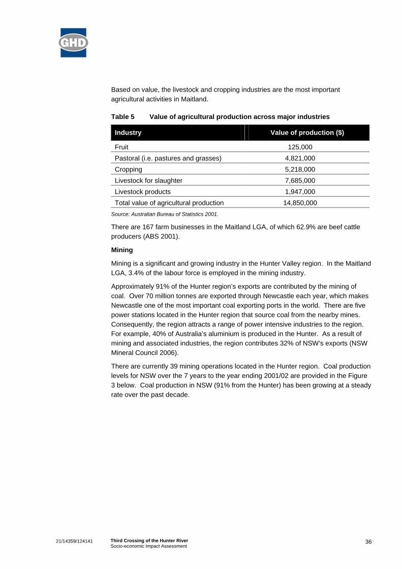
Agriculture
Agriculture makes a significant contribution to the local economy, with agricultural land use accounting for 17,435 hectares (or 44.5%) of the Maitland LGA. The value of agricultural production across a range of industries is provided in the table below.
36
21/14359/124141 Third Crossing of the Hunter River Socio-economic Impact Assessment
Based on value, the livestock and cropping industries are the most important agricultural activities in Maitland.
Table 5 Value of agricultural production across major industries
Industry Value of production ($)
Fruit 125,000 Pastoral (i.e. pastures and grasses) 4,821,000 Cropping 5,218,000 Livestock for slaughter 7,685,000 Livestock products 1,947,000 Total value of agricultural production 14,850,000
Source: Australian Bureau of Statistics 2001.
There are 167 farm businesses in the Maitland LGA, of which 62.9% are beef cattle producers (ABS 2001).
Mining
Mining is a significant and growing industry in the Hunter Valley region. In the Maitland LGA, 3.4% of the labour force is employed in the mining industry.
Approximately 91% of the Hunter region’s exports are contributed by the mining of coal. Over 70 million tonnes are exported through Newcastle each year, which makes Newcastle one of the most important coal exporting ports in the world. There are five power stations located in the Hunter region that source coal from the nearby mines. Consequently, the region attracts a range of power intensive industries to the region. For example, 40% of Australia’s aluminium is produced in the Hunter. As a result of mining and associated industries, the region contributes 32% of NSW’s exports (NSW Mineral Council 2006).
There are currently 39 mining operations located in the Hunter region. Coal production levels for NSW over the 7 years to the year ending 2001/02 are provided in the Figure 3 below. Coal production in NSW (91% from the Hunter) has been growing at a steady rate over the past decade.

37
21/14359/124141 Third Crossing of the Hunter River Socio-economic Impact Assessment
Figure 3 NSW coal production, 1995/96 to 2001/02
Source: Australian Coal Association 2002.
Growth in the mining industry at a national level is indicated in the Figure 4. Industry income shows a strong positive trend over the past 5 years, as does the level of employment, which has increased to an estimated 126,000 persons as at September 2005. The global minerals boom and increasing demand for coal is expected to assist in Maitland’s future economic growth.
Figure 4 Australian mining industry summary statistics
0
10,000
20,000
30,000
40,000
50,000
60,000
70,000
2001 2002 2003 2004 2005
Mill
ions
of D
olla
rs
0
20,000
40,000
60,000
80,000
100,000
120,000
140,000
Empl
oym
ent
Income from sales Company profits Employed persons
Note: Figures reported for the year to September. Source: Australian Bureau of Statistics 2005.

38
21/14359/124141 Third Crossing of the Hunter River Socio-economic Impact Assessment
Commercial Activity Maitland is a growing community that provides opportunity for future development and investment. Maitland City Council reports that ‘an increasing number of Sydney and International companies (are) moving to the Maitland district’. Two Government agencies (the Department of Mineral Resources and NSW Infringement Bureau) have recently set-up offices in the area. Maitland City Council aims to further encourage these trends and encourage businesses to invest in the area through the establishment of industrial estates (Maitland City Council 2006).
Relatively recent examples are seen by the support given to the movement of the Department of Mineral Resources linked also to the centres close proximity to Hunter mining activities. Further, the NSW Infringement Bureau moved to Maitland in 2003.
A proactive council and active local economy could be further expected to attract commercial activity and support the growth of the area.
Retail The retail industry is Maitland’s largest business employer. This is linked with the relatively large size of the tourism industry in Maitland, which is an important and growing part of the local economy. At the 2001 Census, 17.6% of the Maitland LGA population were employed in the retail sector.
The combined space of Maitland’s main retail centres is estimated at over 82,000 square metres. Aside from these 5 major retail centres, the CBD contains a cinema complex, and a bulky goods retail centre. There are also neighbourhood based centres located outside the Maitland CBD at Rutherford, Thornton, Telarah, Tenambit and East Maitland (MCC 2003). There is also a large shopping Centre at Greenhills, East Maitland.
Tourism Tourism is a strong source of revenue for Maitland. Estimates indicate that in 2001 domestic visitor expenditure was $15,078,000 for overnight visitors and $42,285,000 for day-trippers. The main historic attractions include Maitland Gaol, Walka Water Works and Maitland Heritage Mall.
Tourism is a growing industry in Maitland with strong private sector investment and interest in the region. Maitland is currently being promoted under the tourism brand ‘Hunter River Country’, in recognition that the area has a broad tourism appeal beyond the heritage values of the city. Maitland is promoting its reputation as a ‘short break’ tourism destination for the target markets of Sydney, Central Coast, Newcastle and other areas of regional NSW.
A recent survey by Newcastle University (2001) established the origin of visitors to various cultural activities in Maitland. A summary of results are provided in the table below.

39
21/14359/124141 Third Crossing of the Hunter River Socio-economic Impact Assessment
Table 6 The origin of visitors to cultural activities in Maitland
Origin Proportion Newcastle 23.9% Lake Macquarie 20.4% Other NSW 20.4% Sydney 19.0% Port Stephens 6.3%
Source: Newcastle University (2001).
Land use and transport The Maitland LGA has been described as ‘the Hub of the Hunter’ due to its central location in the region. The LGA is situated in close proximity to the junction of the Pacific and New England Highways, and the F3 Freeway to Sydney. It contains a number of significant roads including the two existing bridge crossings of the Hunter River at Morpeth and Maitland. The LGA also has direct access to the Great Northern Railway and North Coast Railway and eight railway stations within the LGA.
According to traffic surveys conducted in 2005, almost 20,000 vehicles per day cross the Hunter River at Maitland and Morpeth. Approximately 14,400 vehicles per day cross the Hunter River at Melbourne St west of Lawes St. With the Proposal, this is expected to increase by 5% to 16,600 in 2016. Approximately 5,700 vehicles currently make the crossing at Lawes St, which is expected to increase by 85% to 8,700.
In peak hours, congestion occurs on Belmore Road at the intersection of High Street, Maitland extending north across the Belmore Bridge and through Lorn. Although not regularly subjected to delays and congestion, the heritage listed Morpeth Bridge must undergo periodic maintenance under restricted traffic conditions. Many residents from Bolwarra and Lorn commute by car south to Newcastle and north to Maitland for employment.
Settlement patterns and transport are inextricably linked. The flood prone nature of much of the Maitland LGA and major transport routes has led to the dispersed nature of the city’s urban settlement. Most of the residential development is distributed south of the Hunter River from Rutherford, Maitland to Woodberry.
Priorities identified by the Revised Maitland Urban Settlement Strategy include investigation areas at Thornton North, Aberglasslyn and Gillieston Heights for residential development. However, investigation areas were also identified at Bolwarra, West Rutherford and Thornton/Beresfield. The opportunities for growth in the rural residential market are widely distributed throughout the LGA in areas already so zoned, and other areas marked for investigation.
In addition there are a number of new residential estates opening up, including one to five acre semi rural plots located within five minutes of Maitland's centre. There are also large residential release areas to the east of Thornton (Somerset Park), plus a new subdivision with Heritage Gardens in Morpeth.

40
21/14359/124141 Third Crossing of the Hunter River Socio-economic Impact Assessment
The Central Maitland and Greenhills commercial areas service an area that extends beyond the Maitland LGA. According to the Maitland Industrial Land Study, 2002, Maitland’s vacant industrial land supply (mainly located in Thornton and Rutherford) is sufficient to supply the market until 2024.
21/14359/124141 Third Crossing of the Hunter River Socio-economic Impact Assessment
GHD Pty Ltd ABN 39 008 488 373
10 Bond Street Sydney NSW 2000 - T: 2 9239 7100 F: 2 9239 7199 E: [email protected]
© GHD Pty Ltd 2006
This document is and shall remain the property of GHD Pty Ltd. The document may only be used for the purposes for which it was commissioned and in accordance with the Terms of Engagement for the commission. Unauthorised use of this document in any form whatsoever is prohibited.
Document Status
Reviewer Approved for Issue Rev No. Author
Name Signature Name Signature Date
1 R. Cotterell A. Raleigh M. Di Genua
1.3.06
2 N. Fisher M. Di Genua
24.7.06