Social Exclusion and - World...
83
POLICY RESEARCH WORKING PAPER 2124 Social Exclusion and Which factors prevent the rural poor and other soc ally Land Administration excluded groups forn havinc in Orissa India access to land In Orissa, in Orissa, India Ida India? Robin Mearns Saurabh Sinha The World Bank South Asia Region Rural Development Sector Unit May 1999 Public Disclosure Authorized Public Disclosure Authorized Public Disclosure Authorized Public Disclosure Authorized
Transcript of Social Exclusion and - World...

POLICY RESEARCH WORKING PAPER 2124
Social Exclusion and Which factors prevent therural poor and other soc ally
Land Administration excluded groups forn havinc
in Orissa India access to land In Orissa,i n Orissa, India IdaIndia?
Robin Mearns
Saurabh Sinha
The World Bank
South Asia RegionRural Development Sector Unit
May 1999
Pub
lic D
iscl
osur
e A
utho
rized
Pub
lic D
iscl
osur
e A
utho
rized
Pub
lic D
iscl
osur
e A
utho
rized
Pub
lic D
iscl
osur
e A
utho
rized

POLICY RESEARCH WORKING PAPER 2124
Summary findings
Mearns and Sinha report on the first empirical study of improve rights for the poor and reduce transaction costs
its kind to examine - from the perspective of - but only if the system is transparent and the powerful
transaction costs - factors that constrain access to land do not retain the leverage over settlement officers that
for the rural poor and other socially excluded groups in has allowed land grabs.
India. They find that: Land in Orissa may be purchased, inherited, rented
* Land reform has reduced large landholdings since (leased), or - in the case of public land and the
the 195Os. Medium-size farms have gained most. commons - encroached upon. Each type of transaction
Formidable obstacles still prevent the poor from gaining - and the state's response, through land law and
access to land. administration - has implications for poor people's
* The complexity of land revenue administration in access to land. Mearns and Sinha find that:
Orissa is partly the legacy of distinctly different systems, * Land markets are thin and transaction costs are
which produced more or less complete and accurate land high, limiting the amount of agricultural land that
records. These not-so-distant historical records can be changes hands.
important in resolving contemporary land disputes. * The fragmentation of landholdings into tiny,
* Orissa tried legally to abolish land-leasing. scattered plots is a brake on agricultural productivity, but
Concealed tenancy persisted, with tenants having little efforts to consolidate land may discriminate against the
protection under the law. rural poor. Reducing transaction costs in land markets
* Women's access to and control over land, and their will help.
bargaining power with their husbands about land, may * Protecting the rural poor's rights of access to
be enhanced through joint land titling, a principle yet to common land requires raising public awareness and
be realized in Orissa. access to information.
- Land administration is viewed as a burden on the * Liberalizing land-lease markets for the rural poor
state rather than a service, and land records and will help, but only if the poor are ensured access to
registration systems are not coordinated. Doing so will institutional credit.
This paper - a product of the Rural Development Sector Unit, South Asia Region - is part of a larger effort in the region
to promote access to land and to foster more demand-driven and socially inclusive institutions in rural development. Copies
of the paper are available free from the World Bank, 1818 H Street NW, Washington, DC 20433. Please contact Geraldine
Burnett, room MCIO-156, telephone 202-458-2111, fax 202-522-2420, Internet address [email protected].
Policy Research Working Papers are also posted on the Web at http://www.worldbank.org/html/dec/Publications/
Workpapers/home.html. Robin Mearns may be contacted at [email protected]. May 1999. (72 pages)
The Policy Research Working Paper Series disseminates the findings of work in progress to encourage the exchange of ideas about
development issues. An objective of the series is to get the findings out quickly, even if the presentations are less than fully polished. Thepapers carry the namies of the authors and should be cited accordingly. The findings, interpretations, and conclusions expressed in thispaper are entirely those of the authors. They do not necessarily represent the view of the World Bank, its Executive Directors, or the
countries they represent.
Produced by the Policy Research Dissemination Center

Social Exclusion and Land Administrationin Orissa, India
Robin Mearns & Saurabh Sinha*
* The study team to Orissa (June-July 1998) comprised Robin Meams (Task Leader, SASRD), Saurabh Sinha(Poverty Research Unit, University of Sussex), and Pramodini Pradhan (Vasundhara, Bhubaneswar). Theteam benefited from discussions with Dr. N.C. Saxena, Secretary (Rural Development), Government ofIndia; Mr B K Sinha, Vice-Chair, Land Reforms Unit, LBS National Academy of Administration,Mussoorie; Dr Kailash Sarap, University of Sambalpur; Dr Mamta Swain, Nabakrishna Centre for SocialSciences, Bhubaneswar; Mr Joe Madiath, Gram Vikas, Berhampur; and senior officials of Govemment ofOrissa, particularly Messrs S. Sahoo, Member (Board of Revenue), J.K. Mohapatra, Secretary (Revenue),B.K. Patnaik, Secretary (Agriculture), and S.P. Thakur, Director (Welfare). Dr. K.C. Shivaramakrishnanof IDS, University of Sussex was most helpful in clarifying certain aspects of land revenueadministration.
TABLE OF CONTENTS
SUMMARY ....... iii
1INTRODUCTION.1
1.1 BACKGROUND.11.2 SCOPE AND OBJECTIVES OF STUDY .11.3 WHY OR I SSA?. 21.4 METHODOLOGY.21.5 ANALYTICAL FRAMEWORK.31.6 STRUCTURE OF THE REPORT.6
2 THE BACKDROP.7
2.1 ORISSA AND THE STUDY DISTRICTS.72.2 LAND REVENUE SYSTEMS OF OR I SSA.112.3 REVIEW OF EXISTING LEGISLATION GOVERNING ACCESS TO LAND IN O RISSA.122.4 WOMEN' S ACCESS TO LAND.152.5 STRUCTURE OF LAND REVENUE ADMINISTRATION IN ORISSA.1 82.6 CONTRIBUTION OF LAND REVENUE TO STATE INCOME.22
3. LAND SUR{VEY AND SETTLEMENT OPERATIONS ........................................ 23
3.1 CADASTRAL SURVEY ........................................ 233.2 PREPARATION OF THE RORS ........................................ 243.3 SETRLEMENT OF RENT................................................................................243.4 CONCLUSION ................................................................................. 26
4. LAND T RANSACTIONS AND STATER ................................................................................ 28
4.1 LAND SALE TRANSACTIONS ................................................................................ 284.1.1 Registration ................................................................................. 284.1 .2 M utation.1 ............................................................................... 4.1.3 Land records management ............................................................................... 324.1.4 Will reduced transaction costs facilitate land sales and increase access to land by rural poor?............................. 40
4.2. LAND FR AGM ENTATION. .............................................................................. 424.2.1 Extent offragmentation.424.2.2 Legal provisions and progress of land consolidation in Orissa.434.2.3 Process of consolidation.444.2.4 Failure of consolidation in Sam alpur.u454.2.5 REesistance to consolidatio n.464.2.6 Policy issues.48
4.3 LAND ENCROACHMENT ...................................... 494.3.1 Typology and extent of encroachments ...................................... 4.3.2 Land alienationTfrom tribal ..................................... 544.3.3 Legal framework and how it operates ..................................... 54.3.4 Conclusion.6 .....................................
4.4 LAND TENANCY ..................................... 574.4.1 Extent and nature of tenancy in Orissa ..................................... 584.4.2 Terms of tenancy contracts ...................................... 594.4.3 Policya mplications. .....................................
5. CONCLUSION ..................................... 63
5.1 POLICY IMPLICATIONS.3 ..................................... 5.2 STAKEHOLDER ANALYSIS .................. ................... 655.3 SUGGESTIONS FOR FOLLOW UP. ..................................... 66
4.24 aiur of on olda io inSa bapu ................................................................. 4
REFERENCES ......................................................................................................................................................... .69
ANNEX: DATA SOURCES AND STRATEGY FOR FIELD INVESTIGATION ........... .............................. 71
LIST OF FIGURES
FIGURE 1: FRAMEWORK FOR ANALYSING GOVERNMENT'S RESPONSES TO LAND TRANSACTIONS ...................................... 5FIGURE 2: ORISSA: DiSTRIBUnON OF HOUSEHOLD OPERATIONAL LAND HOLDINGS, 1953-54 TO 1982 ............................... 8FIGURE 3: ORISSA: SHARE OF TOTAL OPERATED AREAS BY HOLDING SIZE, 1953-54 TO 1982 ............................................. 8FIGURE 4: ORGANIZATIONAL CHART OF REVENUE ADMINISTRATION IN ORISSA ................................................................ 19FIGURE 5: ORGANIZATIONAL STRUCTURE OF DEPARTMENT OF REVENUE AND EXCISE ....................................................... 21
LIST OF TABLES
TABLE 1: LAND USE IN ORISSA ...................................................................................... 9TABLE 2: MAIN PROVISIONS AND IMPACTS OF LAND LEGISLATION IN ORISSA ................................................................... 14TABLE 3: CHANGING SHARE OF STATE REVENUE FROM DIFFERENT SOURCES .................................................................... 22TABLE 4: DESCRIPTION OF CHARGES RELATING TO REGISTRATION OF LAND TRANSACTIONS . . 30TABLE 5: STATE INCOME FROM LAND REGISTRATION ...................................................................................... 31TABLE 6: LOSS OF STATE REVENUE THROUGH UNDER-VALUATION OF PROPERTY ............................................................. 34TABLE 7: ADDITIONAL TRANSACTION COSTS IN THE LAND MARKET .................................................................................. 35TABLE 8: SCOPE OF RESPONSIBILITIES OF REVENUE INSPECTORS ...................................................................................... 39TABLE 9: LAND FRAGMENTATION IN ORISSA BY OPERATIONAL HOLDING SIZE ................................................................. 43TABLE 10: PROGRESS OF LAND CONSOLIDATION IN ORISSA, 1974-98 ............................................................................... 44TABLE 11: PROGRESS AND EXPENDITURE IN LAND CONSOLIDATION IN ORISSA, 1995-98 .................................................. 44TABLE 12: IMPACT OF LAND CONSOLIDATION ON ONE HOLDING, SAMBALPUR DISTRICT ................................................... 46TABLE 13: ENCROACHMENT BY LAND CATEGORY ....................................................................................... 52
TABLE 14: TYPOLOGY OF LAND TENANCY CONTRACTS IN DIFFERENT PARTS OF ORISSA ................................................... 60TABLE 15: COMMON REASONS FOR LEASING LAND IN ORISSA ...................................................................................... 60TABLE 16: WHO WILL BENEFIT AND HOW: STAKEHOLDER ANALYSIS ............................................................................... 67TABLE 17: CONFLICT AND COMPLEMENTARITY IN STAKEHOLDER INTERESTS ................................................................... 68
LIST OF BOXES
Box 1: DISTRICT RE-ORGANIZATION IN ORISSA ...................................................................................... 10BOx 2: MAIN SYSTEMS OF LAND REVENUE ASSESSMENT IN ORISSA PRIOR TO INDEPENDENCE ........................................... 11Box 3: ExTENT OF LAND REVENUE SYSTEMS IN ORISSA AT INDEPENDENCE ...................................................................... 12Box 4: CONSTRAINS ON WOMEN'S ACCESS TO LAND ...................................................................................... 15Box 5: WHEN CAN WOMEN HAVE LANDS REGISTERED IN THEIR OWN NAMES? ................................................................... 17Box 6: NATURE OF OBJECTIONS AT A SETTLEMENT CAMP ...................................................... 25Box 7: 'THEY KNOCK ON YOUR DOOR TO COLLECT BRIBES' .27Box 8: WOULD A REDUCTION IN STAMP DUTY INCREASE STATE REVENUE? . 33BOX 9: COMPUTER-AIDED REGISTRATION ADMINISTRATION SYSTEM (CRAS) .40Box 10: 'WE DO NOT INTEND TO MOVE': RESISTANCE TO LAND CONSOLIDATION IN LADERPALLY VILLAGE, SAMBALPUR 47Box 11: HOW DEVELOPMENT CAN REDUCE ACCESS TO LAND .51Box 12: OPERATION OF THE OPLE IN GANJAM DISTRICT .56Box 13: TENANT MOTIVATIONS FOR CONCEALING TENANCY .61
ii
SUMMARY
This report presents an exploratory, state-level analysis in Orissa of the factors that constrain access to land bythe rural poor and other socially excluded groups. It is the first empirical study of its kind, at least in India,which examines access to land from a transaction costs perspective. It is based on an institutional analysis ofland administration in policy and practice, and considers the consequences for particular groups ofstakeholders. The intention of this pilot study was to field-test an approach that could be replicated in otherstates of India, with a view to identifying incremental reforms in lasd administration and policy that could helpto improve access to land for the rural poor. The findings should be regarded as preliminary, since the studywas intended to scope the broad framework for analysis, rather than to produce systematic results.Nonetheless, the findings do suggest a set of broad policy implications worthy of more detailed consideration,following systematic analysis in other states.
Land distribution: While land reforms legislation has reduced the share of operational area held under largeholdings (> 6 ha) in Orissa since the 1950s, the major gains have been in the share of total area accounted forby medium-sized farms. Over half of all households operate small, marginal or sub-marginal land holdings (<2 ha). The proportion of total agricultural land they operate has remained substantially unchanged since the1950s, although substantial gains in area accrued to the largest among them during the 1960s, thereby swellingthe ranks of farm households with medium-sized holdings by the 1970s. The proportion of householdsoperating no land, whose livelihoods are based principally on agricultural labor, increased substantiallyfollowing the widespread eviction of tenants from erstwhile landlord estates, and by the early 1 960s accountedfor a third of all households. Since the 1960s, some have gained access to at least some land, but around aquarter of all households in Orissa still operate no land. Overall, in spite of land reforms, socio-economic anddemographic change over the last half century, these trends suggest that formidable obstacles continue toprevent the rural poor from improving their access to private arable land.
Land revenue systems: Historically, different parts of the state inherited different land revenue administrationsystems from Bengal Province (northern Orissa), Madras Presidency (southern Orissa), Central Provinces(western Orissa), and the former princely states. Some 80 percent of the total area fell under zamindarisystems, in which many layers of 'intermediaries' between the landlord and cultivator were responsible forexacting land revenue. Ryotwari (peasant-proprietor) systems prevailed over parts of southern Orissa that hadbeen under Madras Presidency. Some of the complexity of land revenue administration in Orissa today may beattributed to the legacy of these diverse systems, which were brought under a unified legislative structure onlyfollowing independence. The legacies of these distinct systems also have certain lasting effects on the ground.For example, land records tend to be more complete and accurate in the former ryotwari areas in which, unlikein zamindari areas, there were village accountants. This not-so-distant historical record can be important inresolving land disputes even today, in establishing the basis for contemporary land claims.
Main provisions in land legislation: Orissa is one of a few states in India that has attempted legally to abolishtenancy (land-leasing), except in the case of persons of disability (the definition of which includes widows,divorcees, and other unmarried women). Land rights may pass to any cultivator who can demonstratecontinuous occupation over a period of at least 12 years ('adverse possession'). While tenancy remainswidespread, these restrictions have led to concealed forms (e.g. oral contracts) which give tenants little or noprotection in law. A ceiling on individual land holdings also applies, and currently stands at 10 'standardacres' (depending on land quality). In addition to these provisions, which fall under land reforms legislation,three major Acts govern land administration, and respectively provide the basis for land survey and settlement,land consolidation/ prevention of land fragmentation, and prevention of encroachment on government land.The Government of Orissa has recently prepared a draft Revenue Administration Bill, intended to simplify,consolidate and replace these separate laws governing land administration. The clause permitting theliberalization of the land-lease market remains an obstacle to the rapid enactment of-this law.
iii
Gender and land rights: As in other parts of South Asia, women may appear to enjoy certain land rights inlaw, but they rarely translate into effective control over land in practice, owing to embedded, gender-biasedsocial norms and customs. It is suggested that women's access to and effective control over land may beenhanced through joint land titling. This measure is rather limited in scope, since ideally what need to bepromoted are women's independent land rights. But while the principle of joint titling is readily accepted at thelevel of the Government of India, it has yet to be realized in practice in Orissa. In focus group discussions,village women assert that their bargaining power vis a vis their husbands and in-laws would be enhancedconsiderably by joint title over land. The common objection that this may make it more difficult for women toescape from abusive marriages was for them a second order consideration.
Organization of land administration: Land administration in Orissa is carried out by two, parallel governmentagencies: the Department of Revenue and Excise, responsible for policy formulation and revenue collection;and the Board of Revenue, responsible for the implementation of land policy and judicial matters. Landrevenue has declined as a share of state revenue from over 30 percent to less than 2 percent over the last fortyyears. As a result, land administration is perceived as a burden on the state, rather than a service which, ifmade more efficient, could potentially contribute to raising agricultural productivity. Stamp duties and otherfees payable upon the registration of land sales, on the other hand, account for up to 6 percent of state revenue.There is little or no coordination between the maintenance of land records, which is the responsibility ofrevenue inspectors and tehsildars; and land registration, which is the responsibility of sub-registrars. Measuresto coordinate these two services and enhance their efficiency through computerization, while at the same timereducing transaction costs to individuals in the land market, could go a long way towards stimulating the landmarket. Whether or not this would enhance access to land for the rural poor, however, depends on the degreeof transparency with which land administration is conducted in practice. Access to information and publicawareness of rights seem to be critical factors. A recent initiative of the Revenue Department, Government ofOrissa, to disseminate a local-language 'how to' manual on matters of land transfers and access to landrecords, is a most welcome contribution in this area.
Land survey and settlement operations: Survey and settlement operations evolved historically as a way toestablish a record of rights in land, on which to base the assessment of land revenue. Periodic, revisionalsurveys, conducted every 25-30 years or so, serve as the major means to update land records. Since the processof mutation following an individual land sale-purchase transaction is burdensome, protracted and (for many)prohibitively expensive, many land holders prefer to wait until the next revisional survey to obtain title to theirland. In practice, the survey and settlement process provides widespread opportunities for rent-seeking on thepart of the govermnent officers involved, and it is not uncommon for poorer and less powerful landholders to'lose' at least a proportion of their land in the official record. Land-grabbing by more powerful individuals,facilitated by exerting leverage over settlement officers, appears to be commonplace during survey andsettlement operations. While the contested amounts of land are usually small, the net effect is systematically todiscriminate against the rural poor and the socially excluded.
Four types of land transaction are considered in the main analysis. Land may be purchased, inherited, rented(leased) or, in the case of commons and public land, encroached upon. Each of these types of transaction, andthe state's responses through land law and administration, has particular implications for the ability of the ruralpoor to improve their access to land.
Land sale-purchase transactions: These are estimated to account for around 80 percent of land transactions atvillage level, although the share of total agricultural land changing hands is typically as low as 5-7 percent peryear. Land markets are thin for various reasons. In large part, there are few willing sellers of land, as the priceof land does not reflect its full social value. Most sales are therefore distress sales by smaller farmers, and mostpurchases by larger farmers. High transaction costs in land markets are also a significant obstacle to land
iv

purchases. Uncertainty regarding the true ownership of the land is rarely a serious concern in the case ofintra-village transactions. However, many sale-purchase transactions go unrecorded in land records, since theprocess of mutation (voluntary registration of a sale deed and acquisition of title) is complex, lengthy andexpensive. Officially sanctioned transaction costs amount to at least 17 percent of the value of the landtransacted, and the 'informal' transaction costs required to expedite the process may amount to as much again,even discounting the opportunity costs of repeated visits to registrar and tehsildar's offices over a period ofseveral years. The computerization of land records may contribute to a reduction in these transaction costs, butonly if coordinated with computerized land registration.
Landfragmentation: the fragmentation of land holdings into tiny, scattered plots is a consequence of thecustom of partible inheritance, in which each individual plot is subdivided among various heirs. There is thus alifecycle effect, in which newly formed households acquire very small holdings on the subdivision of formerlyjoint family holdings. Land fragmentation is widely perceived to operate as a brake on agriculturalproductivity, and the Government of Orissa has responded by implementing a land consolidation programsince 1974. Land consolidation does not contribute directly to improving access to land for the rural poor,since it aims to leave land distribution unchanged. But as in the case of survey and settlement operations, thereis some evidence that land consolidation operations result in a certain amount of discrimination against therural poor and other socially excluded groups. In spite of continuing demographic pressure, the rate offragmentation actually declined from an average of 6.4 to 5.0 parcels per holding between 1961-62 and 1981-82. Much of this decline took place before the impact of the land consolidation program could be observed,which suggests that a certain amount of individually initiated land consolidation takes place through thevoluntary exchange of land plots in the market.
Evidence from the field confirms that land fragmentation persists for two main reasons: the need to spreadrisk, particularly in unirrigated areas and where soil quality is more variable; and the need to hold land as aliquid asset, which may be sold off in discrete parcels to meet contingencies such as marriage or funeral costs.No data exist in Orissa on the rate of fragmentation by district or region. Findings from the field suggest thatland fragmentation is perceived by farmers to be a more serious problem on the coastal plains, where land ismore reliably watered and soils are more uniform in quality, than in the hill areas of western Orissa, wherethere has been considerable resistance to the government's land consolidation program. To the extent that bothpoorer and better-off farmers wish voluntarily to consolidate their holdings in the interests of raisingproductivity, the most effective public interventions are likely to be those that reduce transaction costs in theland market.
Encroachment on comnons: The rural poor partially compensate for their lack of access to private, arableland through access to public/ common land. Commons account for an estimated 20 percent of the total landarea of Orissa, including 'wastelands', grazing lands, and certain types of forest land. Over recent decades, thebest quality common land has been encroached upon by both resource-poor and resource-rich farmers, andwhat remains is frequently too degraded to be of significant value. Legislation exists to prevent encroachmenton government-owned 'wastelands', and to transfer a up to an acre of 'unobjectionable' public land to landlessfamilies, but is largely ineffective on both counts. There are powerful incentives for revenue inspectors to takebribes from encroachers to permit continued cultivation, rather than to initiate eviction proceedings. Morepowerful individuals may thereby acquire permanent occupancy rights through 'adverse possession'. Whilethe rural poor also acquire defacto but insecure rights over revenue wastelands through encroachment, theyare often unable to convert them to the de jure rights to which they are legally entitled, since the act ofencroachment is regarded as illegal in the first instance. Access to commons is especially important in thelivelihoods of the 22 percent of Orissa's total population who live in 'scheduled' tribal areas. In spite of legalrestrictions on transfers of land owned by people of scheduled tribes to non-tribal people, land alienation fromindebted tribal families remains a persistent problem.
v
The most promising avenues for protecting rights of access to common land for the rural poor are throughefforts to raise public awareness and access to information. Some NGOs in Orissa have been successful inpursuing public interest litigation to defend tribal land rights. Following their lead, the strengthening of localpanchayats could make a vital contribution towards promoting the watchdog function of civil societyinstitutions. Only with strong civil society institutions will there be effective demand from below foraccountability within the lower levels of land revenue administration, thereby limiting the possibilities forevasion of the legislation designed to prevent encroachment on commons. With such safeguards in place, thecomputerization of land records at tehsil level would also contribute towards making information on the extentof encroachment more publicly accessible.
Land leasing (tenancy): The Orissa Land Reforms Act prohibits sub-letting of land, regulates rents (to amaximum of one quarter of gross produce), and grants occupancy rights to long-standing tenants. In spite ofthese restrictions, tenancy remains widely prevalent, under 'illegal' contracts which landlords and tenants havea common interest in concealing. This accounts for widespread under-reporting of the area leased-out (and, toa lesser extent, leased-in). The best available estimates suggest that on average, around 20 percent of farmhouseholds participate in the land-lease market, and that over 80 percent of leasing activity (both in and out) isby small and marginal farmers.
There is wide inter- and intra-regional variation in both leasing activity and the terms of tenancy contracts.Sharecropping is the predominant form of tenancy contract in Orissa, accounting for perhaps half of the totalleased-in area, although it is declining over time in favor of fixed-rent contracts (whether in cash or in kind).Share tenancy remains more prevalent in non-irrigated villages, owing to its greater potential for risk-sharingbetween tenants and landlords. In irrigated villages, fixed-rent tenancies may now account for three quarters ofland-lease contracts. Contract terms vary widely, depending on the respective labor and capital contributionsof tenant and landlord, the crops being produced, and extent to which the physical location of the leased-outplots permits close supervision. Regardless of the nature of the contract, rents are invariably higher than thelegally stipulated maximum of one quarter of gross production.
The land-lease market is clearly an important means by which the rural poor gain access to land. While there islittle evidence of exploitative relations between landlords and tenants, there is some evidence that markets forother factors - particularly labor and, to a lesser extent, credit - are interlinked with the land-lease market.These interlinkages explain why it is also in tenants' interest to conceal tenancies, and why tenants arereluctant to press claims for lower rents or more secure rights of occupancy. Under these circumstances,liberalization of land-lease markets may well enhance access to land by the rural poor, but will be of mostbenefit to them if they can also be assured access to institutional credit. The liberalization of the land-leasemarket, as proposed in the draft Orissa Revenue Administration Bill, and supported by Govemment of Indiapolicy under the Ninth Plan, is therefoTe cautiously to be welcomed, provided that the right balance can bestruck between assuring landlords of their long-term ownership rights, and assuring tenants of their security oftenure and protection under the law for the duration of fixed-term tenancy contracts. Only with documentaryevidence of such rights are tenants likely to face the possibility of access to institutional credit.
vi
1 INTRODUCTION
1.1 Background
Access to land is of fundamental importance in rural India. It remains the principal determinant of ruralincome distribution, although the direction of causality in this relationship is not clear. The weight ofinternational evidence now strongly endorses a strategy for rural economic growth that is based on small yeteconomically viable, family-run farms. In the Indian context, in which a large and rising share of the ruralpoor derive livelihoods principally from their own labour, a powerful case can be made in favor of moreequitable land distribution on grounds that such a strategy would generate more employment than alternatives.In sum, with the overall objectives in mind of reducing poverty, raising agricultural productivity, andpromoting social inclusion, there are strong arguments for seeking ways to improve access to land for the poorand other socially excluded groups in rural Indial.
Conventional approaches to improving access to land for the rural poor, both in India and elsewhere, havefocused on land and agrarian reform. Land reform is perceived by some to be rising up the political agendaonce again in many states of India. In the Ninth Five-Year Plan (1997-2002) the Department of RuralDevelopment, Government of India, is focusing on land reforms, including new strategies to benefit sociallyexcluded groups such as the selective liberalization of land-lease markets, and the promotion of women's landrights. Although state-imposed, redistributive land reforms are conventionally believed to have beenunsuccessful in the Indian context (with notable exceptions), recent evidence suggests that much more hasbeen achieved in implementing Indian land reform legislation than is often supposed. Nevertheless, theprospects for bringing about a meaningful improvement in access to land by the rural poor may be evenstronger if attention is turned now to more limited, pragmatic measures, such as the selective deregulation oflease markets; and incremental reforms in land administration to facilitate more rapid, fairer, and cheaperconveyancing procedures. Such institutional reforms would also help to meet some of the preconditionsnecessary for the successful implementation of land consolidation and/or land redistribution programs whereappropriate.
1.2 Scope and objectives of study
In FY98 the South Asia Rural Development Sector Unit of the World Bank initiated an informal study onaccess to land in rural India. The overall objectives were to contribute to poverty reduction and ruraleconomic growth in selected states of India by: (i) identifying feasible legal and institutional reforms, policyinstruments, or other mechanisms to improve access to land, particularly for the rural poor and other sociallyexcluded groups; and (ii) determining the potential role for the Bank (if any) in supporting such reforms,instruments and mechanisms.
During Phase I of the study, an overview policy issues and options paper (Mearns, 1998) was prepared basedon literature review and consultations with specialists within and outside the World Bank. The aims and scopeof this review were: (i) to exanine the broad context of land relations in rural India; (ii) to identify the majorconstraints on access to land by the rural poor and other socially excluded groups; (iii) to suggest priority areas
1 Patterns of social exclusion tend to be closely correlated though not synonymous with the incidence of poverty. It iswell recognized that people of scheduled tribes and scheduled castes in India are much more likely than other groupsto live below the poverty line. Throughout this paper, 'socially excluded groups' refer to people of scheduled tribesand castes, women, and the rural poor. All of these groups are more likely than better-off or more powerful andinfluential groups to suffer from forms of discrimination at the hands of those government officials with whom theycome into contact, and to be more or-less excluded from receiving entitlements through administrative procedures.
I
for legal, policy and institutional reform to help reduce these constraints; and (iv) to identify areas wherefurther work is required in selected states to identify feasible legal, policy and institutional reforms.
The present paper, which should be read in conjunction with the overview paper, constitutes Phase II of thestudy. It offers a more detailed institutional and stakeholder analysis of constraints on access to land by therural poor at state level, as presented by the land administration system both in policy and in practice. At thecore of this analysis is an attempt to specify the formal and informal transaction costs incurred by individualsin the land market. Based on this analysis, priority areas for legal, policy and institutional reform are identified.The state of Orissa was selected for this pilot study. The intention was to refine and document the approach,research questions, and methodology so as to provide a 'template' for subsequent studies in other states ofIndia. Although land administration is a state subject under India's constitution, matters relating to land reformrequire concurrence at federal level. The prospects for meaningful reform of land administration at the level ofIndia as a whole will be enhanced through policy dialogue based on comparative information on the diverseground realities prevailing in a number of states.
1.3 Why Orissa?
Several criteria guided the selection of Orissa for this pilot study:
* there is considerable diversity in agrarian systems and patterns of land tenure throughout the state ofOrissa, which offers an opportunity for comparative analysis and suggests a need to tailorrecommendations accordingly;
* access to land has already been identified as a priority by the Government of Orissa (GOO), and strongdemand voiced by GOO for such a state-level study to be conducted by the Bank. The possibility ofderegulating land-lease markets (tenancy), and measures to reduce land fragmentation, were identified byGOO as issues of particular policy concern;
* the study findings and recommendations may be of direct operational relevance in the context of the OrissaRural Development Project, currently under preparation by GOO for possible Bank support.
1.4 Methodology
So far as we are aware, this is the first empirical study of its kind which examines access to land from atransaction costs perspective. The methods and strategies adopted in the field investigation were necessarilyexploratory. The availability, quality, and sources of data were unknown at the outset, and a certain amount ofiteration was required between the initial research questions and what could realistically be achieved within thetime available. Limited information was available from secondary sources (particularly village studies) forcertain, discrete aspects of the research (e.g. tenancy, land fragmentation, or encroachment on commons).However, the overall approach adopted here - namely, to analyze the factors affecting access to land within aholistic framework, including an institutional analysis of land administration in policy and practice, andconsideration of the distributional consequences for particular groups - is otherwise untested.
The broad methodology for the pilot study in Orissa included (see Annex for further details of data sources andstrategy for field investigation):
* a review of the existing legislative, regulatory, and judicial framework governing access to land in Orissa toidentify specific consequences for the rural poor and other socially excluded groups;
* extensive discussions with principal stakeholders involved in policy-making, land revenue administration,and transacting in land to identify the roles and strategies of different actors or stakeholders;
2

* visits to ongoing survey and settlement and land consolidation camps to understand, at first-hand, theoperations and functioning of these aspects of land administration; and
* focus-group discussions in villages (in each of three selected districts) to appreciate the ways in which theactual outcomes of various land administration procedures differ from their intended outcomes, and withwhat possible consequences for the rural poor and other socially excluded groups.
It is important to be clear about the limitations of this pilot study. In part owing to the short time available, itwas not considered desirable to attempt to administer a formal, structured questionnaire within a statisticallyrigorous sampling frame. Rather, semi-structured interviews were conducted with individual informants andfocus groups, based on a checklist of research questions. Participatory diagramming methods were also usedon occasion. In order to understand the practical functioning of the land administration system, considerableflexibility and serendipity is required on the part of the interviewer in the pursuit of unexpected leads, whichwould not be possible with a standardized questionnaire. The data reported are considered to be trustworthy,on the grounds that care was taken to cross-check the information obtained among diverse informants andresearch methods. Such 'triangulation' is one of the principal means of assuring data quality when usingparticipatory learning methods.
We found villagers to be generally willing to discuss their experiences on the 'receiving end' of the landadministration system. Issues relating to the payment of bribes to lower-level government officers could beopenly discussed. We have discounted some of the individual reported figures in several instances, followingcross-checks with other informants. By and large, however, the regularities in individual responses across thestate gives a measure of confidence in the broad picture that emerges. Rent-seeking was found to besufficiently pervasive that it was possible to specify the 'going rate' in many instances. The principal limitationof the methodology adopted is that in the short time available, it was not always possible to probe variations assystematically as one would have liked, with the attendant risk that an impression of greater uniformity isconveyed than is in fact the case. Based on this pilot study, estimates of the minimum amount time required tocomplete certain stages of the field investigation are provided in the Annex.
1.5 Analytical framework
Rights in land fall within a hierarchy ranging from the highly restricted to the fully specified. 'Ownership' hererefers to the most specified forn of rights in land that prevail in Orissa, including rights to use exclusively,inherit, bequeath, and transfer by sale or gift. Even with privately owned agricultural land, certain restrictionsapply on the uses to which that land may be put. Under 'adverse possession', it is also possible that ownershiprights may be lost to another party if their continuous possession of the land for a period of at least 12 yearsduration can be demonstrated. Aside from such restrictions, ownership rights are the most secure form ofrights in land and enjoy protection in law.
At the bottom of the hierarchy of rights in land fall usufruct (use) rights, particularly if those use rights aredeclared illegal and are therefore highly insecure. An example would be customary claims of tribal groups tocultivate on forest department land, which are declared illegal under the 1980 Forest Conservation Act. Rightsto use village commons (e.g. for grazing livestock, gathering fuelwood or fodder) are a more secure form ofusufruct right, but may be compromised in practice if those commons have been encroached. Occupying anintermediate position in the hierarchy of rights are legal rights which, owing to prevailing social norms andcustoms, may not actually be realised in practice. Women's rights to own land independently often fall intothis category.
In general, access to land may be enhanced through the extension of an individual's existing rights or claimsover a larger land area, or the transfer or acquisition of a new class of rights in land, provided they are actually
3
enjoyed in practice. Security of tenure refers to the degree of confidence an individual has that his or herrights in land will be upheld in practice. Ownership and usufruct rights in land can be transferred or acquiredthrough privately initiated land transactions in four ways:
Land sale, which is the permanent transfer of privately-held ownership and usufruct rights. Land sales arepermitted so long as the purchaser's total land ownership holding does not exceed the ceiling limit;
Land inheritance, which normally occurs on the death of a land holder, and results in the partitioning of aprivately owned land holding among two or more claimants. All rights are transferred to the claimants. Thisprocess also frequently leads to landfragmentation which, owing to spatial variation in land quality, generallytakes the form of the subdivision among each claimant of each individual plot in the total land holding.Administrative attempts are made to restrict land fragmentation in the interests of increasing or at leastmaintaining agricultural productivity;
Land encroachment, which refers to the forcible, defacto 'privatisation' of common or government land.Although encroachment is illegal, the government also seeks to redistribute ownership rights over some publicland ('wastelands') to landless households. This apparent entitlement is treated separately from the question ofencroachment, however, so that it is not possible for a landless household to press a claim through aspontaneous act of encroachment; and
Land lease or tenancy, which,occurs when usufruct rights over a plot of land are transferred for a specifiedperiod and for a share in the output (share-cropping), or against a fixed (cash or kind) rent. Ownership rightsremain with the original owner. The leasing of land is prohibited under Orissa law, though widely prevalent inconcealed forms (oral contracts).
A principal function of land administration is to maintain an authoritative record of the status and fiscalobligations of cultivators, to protect their rights, and to avoid agrarian disputes. Land records in India wereinitially established by means of survey and settlement operations. Periodic, revisional surveys are undertakenevery 25-30 years or so. All land transfers completed during the intervening period between survey andsettlement operations are recorded at the time of the revisional survey and reflected in the updated record-of-rights (RORs) in land. With an increasing volume of land transactions, state governments have had to devisevarious mechanisms to respond to these transactions. Survey and settlement (section 3) is still undertaken inOrissa without being a response to any specific transaction.
Government's response to individual land transactions is conditioned by the existing legal framework. Thus,land sale transactions (section 4.1) are registered and the ROR updated through the regular process of mutationwhich, in principle, takes place as and when the transaction occurs. Land fragmentation (section 4.2) isperceived adversely to affect agricultural productivity. In response, the government implements a landconsolidation program designed to reverse fragmentation through the redistribution of scattered plots intocompact blocks without significantly affecting land distribution among individual land holders. Land recordsare also updated following a consolidation operation. The government's response to encroachment (section4.3) is ambiguous as it ostensibly seeks to evict encroachers from common land, but is more lenient withrespect to encroachment on revenue wastelands. At the same time, while landowners may be penalised andevicted for encroaching on wastelands, landless households are legally entitled to be settled on (i.e. acquireownership rights over) that land. Land leasing (section 4.4) is not recognised by the Government of Orissaand, in spite of being widely prevalent, is largely concealed.
This study systematically analyses each type of land transaction and the government's responses to examinehow the interplay between the two impinges upon access to land by the rural poor. The analytical framework isdepicted in Figure 1.
4

r----------l*------------
Survey and Settlement 1 Once inI Operations 2 y
s r ' ' ~~~~~~~~~~~~~~~~~~~~~25-30 years P
Permitted Dsubject to , } Sale I i Registration Regular
ceiling I I l , , of Sale Deeds Mtt Aceiling Mutation
T
Restricted ILand Consolidati on Once E
Ambiguous Encroachment e R0
R
i i ~~~~~~~~~~~~~~~~~~~~~~~~~~~~~~~sProhibited &
i| Lease |i
MAPS
Privately-initiated State responses Function of landland transactions revenue administration
|Figure 1: Framework for Analysing Government's Responses to Landrransactions
5

1.6 Structure of the report
The rest of the report is organised into four sections. Section 2 provides a brief introduction to the state ofOrissa and the three selected study districts, the legal framework (including that governing women's access toland), and theagencies responsible for implementing land revenue legislation. This section provides importantbackground information for the main analysis. Section 3 describes the nature and consequences of land surveyand settlement operations, and assesses their continuing relevance.
Section 4 forms the analytical core of the report. Using the framework developed above (Figure 1), thissection considers each of the four processes by which land rights can be transferred from one party to another,critically analyses the institutional responses on the part of the state land revenue administration, and assessesthe practical consequences for the ability of the rural poor and other socially excluded groups to increase theiraccess to land.
The concluding section identifies potential policy options suggested by the analysis, considers theirimplications for various stakeholder groups, and outlines suggestions for follow-up, including similar studiesin other states.
6

2 THE BACKDROP
2.1 Orissa and the study districts
On the basis of its physical features and agro-climatic conditions, Orissa can be divided roughly into fourzones (see Map):
1. the northern plateau covering the districts2 of Mayurbhanj, Keonjhar, Sundargarh and part of Dhenkanaldistrict, constitutes 23 percent of the state's total geographical area,
2. the central river basin encompassing Bolangir, Sambalpur and Dhenkanal districts, also covers 23 percentof its landmass,
3. the eastern Ghat region includes the erstwhile Kalahandi, Phulbani, and Ganjam and Koraput districts andis spread over 36 percent, and
4. the coastal plains of Balasore, Cuttack, Puri and a part of Ganjam make up the remaining 18 percent.
The coastal plain region is the most agriculturally advanced in the state as a result of high soil fertility andmore widespread availability of irrigation.
Orissa is the second poorest state in India (after Bihar). Some 87 percent of the total population of 32 million(1991 census) live in rural areas, and 50 percent of the rural population (head count index) live below thepoverty line (World Bank 1998). While employment in Orissa's rural non-farm sector grew at a rate of 2.8percent a year over 1981-91 (Samal, 1997), the great majority of the rural population continue to depend uponagriculture and allied sectors.
Figure 2 shows the distribution of household operational land holdings by size class. It indicates the change inland distribution brought about by post-Independence land reforms (section 2.3), combined with demographicand socio-economic change. Over the period 1953-54 to 1961-62, the number of households not operating anyland increased substantially, following widespread evictions of tenant farmers after the abolition of largelandlord estates (sections 2.3 and 4.4). Estates abolition and the enforcement of an upper ceiling on landholding size appear to have been reasonably effective in reducing large (greater than 6 ha) operationalholdings from 5 percent to I per cent of the total between 1953-54 and 1982. Over the same period, thegreatest gains were in marginal (0.4 - I ha) holdings, which increased from 17 percent to 24 percent of all landholdings. These are small, but not the smallest land holdings. The share of households operating no landdeclined over the 1960s, as the number of households acquiring sub-marginal (less than 0.4 ha) and marginalholdings increased, and by 1982 remained at around 25 percent of all households, which is comparable withthe all-India average (Meams 1998).
2 The districts mentioned in this section refer to the 13 'undivided' districts. As described in Box 1, there are now 30districts in the state (see Map).
7
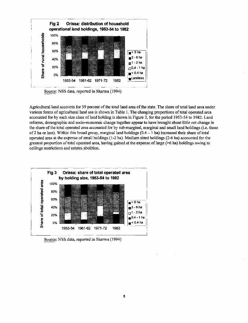
Fig 2 Orissa: distribution of householdoperational land holdings, 1953-54 to 1982100%
0m0)2 860%% ! e :
40% ~ Ml 1-2 ha
o 20% l]0.4 -I haCu
1953-54 1961-62 1971-72 1982
Source: NSS data, reported in Sharma (1994)
Agricultural land accounts for 59 percent of the total land area of the state. The share of total land area under
various forms of agricultural land use is shown in Table 1. The changing proportions of total operated area
accounted for by each size class of land holding is shown in Figure 3, for the period 1953-54 to 1982. Land
reforms, demographic and socio-economic change together appear to have brought about little net change in
the share of the total operated area accounted for by sub-marginal, marginal and small land holdings (i.e. those
of 2 ha or less). Within this broad group, marginal land holdings (0.4 - 1 ha) increased their share of total
operated area at the expense of small holdings (1-2 ha). Medium sized holdings (2-6 ha) accounted for thegreatest proportion of total operated area, having gained at the expense of large (>6 ha) holdings owing to
ceilings restrictions and estates abolition.
Fig 3 Orissa: share of total operated areaby holding size, 1963-54 to 1982
2! 100%
~ 80%
a 60% ,
0 ~ ~ ~ ~ ~ ~~ > 6 ha.9 40% ~ 2 -6 ha0
20 ~1- 2 ha20% Ej 0.4-1 ha
0% 00%~~0 ~ 1953-54 1961-62 1971-72 1982
Source: NS S data, reported in Sharma (1 994)
8

Table 1: Land use in Orissa
Land use Share of total area (%)Agricultural land (gross cropped area), of which: 59
Net area sown 41Tree crops 6Grazing land 4Cultivable wasteland 3Uncultivable wasteland 3Fallow land 2
Forest land, of which: 36Reserved forest area 17Protected forest area 10Other (e.g. panchayat land & village forests) 9
Non-agricultural land 5Total land area (15,540,000 ha) 100
Source: Directorate of Economics & Statistics, Bhubaneswar
Forest land makes up 36 percent of the state land area (Table 1). Over a fifth of the state population are tribalpeople whose livelihoods are traditionally derived from forest products. For administrative and managementpurposes, forests in Orissa are divided into three categories: reserve (representing almost half of the totalforested area), protected (just over a quarter of forested area), and other (a quarter of the forested area),including village forests. Reserve forests are fully under the control of the Forest Department and aremanaged under various silvicultural systems. In protected forests, only the forest crop (i.e. trees) is managedby the Forest Department; the land is owned and controlled by the Revenue Department. Rights and privilegesof local communities vary by the type of forest - restricted in reserved forests and more liberal in protectedforests. Village forests are generally treated as open access lands with no investment from government, and aregenerally extremely degraded except where community protection has started (Saxena, 1996; Singh, 1995).
There are now 30 districts in Orissa (see Map). The process of district re-organisation is described in Box 1.
Three districts were selected for intensive study. The objective was to capture some of the intra-state variationin land tenure, agricultural and rural livelihood systems. Initially, it was assumed that much of this variationwould stem from the historical legacy of the different land revenue systems prevalent in the state at the time ofIndependence. Consequently, one district was selected from each of: the former Bengal revenue system(Khurda district); Madras revenue system (Ganjam); Central Province system (Sambalpur). Dhenkanal districtwas also selected to represent the former princely states of Orissa, but had to be dropped from the fieldinvestigation owing to time constraints. As the study progressed, it became clear that there were indeed manydifferences among the three selected districts in the extent and nature of private land transactions, but thesedifferences did not obviously or directly result from the legacies of different land revenue and tenure systems.Rather, they may be attributed to a combination of social, economic, and topographical factors. For instance,there is some evidence that land fragmentation is a serious problem in the coastal plains. At the same time,there are many similarities with respect to land markets. The land sales market is more or less uniformlydepressed throughout the state. Tenancy is widely prevalent in spite of being banned throughout the state.
9
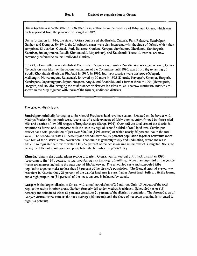
Box 1: District re-organisation in Orissa
Orissa became a separate state in 1936 after its separation from the province of Bihar and Orissa, which wasitself separated from the province of Bengal in 1912.
On its formation in 1936, the state of Orissa comprised six districts: Cuttack, Puri, Balasore, Sambalpur,Ganjam and Koraput. By 1949, the 24 princely states were also integrated with the State of Orissa, which thencomprised 13 districts: Cuttack, Puri, Balasore, Ganjam, Koraput, Sambalpur, Dhenkanal, Sundargarh,Keonjhar, Balangirpatna, Boudh-Khonmandal, Mayurbhanj, and Kalahandi. These 13 districts are nowcommonly referred to as the 'undivided districts'.
In 1973, a Committee was established to consider the question of district/subdivision re-organisation in Orissa.No decision was taken on the recommendations of the Committee until 1990, apart from the renaming ofBoudh-Khondmals district as Phulbani in 1986. In 1992, four new districts were declared (Gajapati,Malkangiri, Nowarangpur, Rayagada), followed by 10 more in 1993 (Khurda, Nayagarh, Sonepur, Bargarh,Kendrapara, Jagatsinghpur, Jajpur, Nuapara, Angul, and Bhadrak), and a further three in 1994 (Jharsuguda,Deogarh, and Boudh), bringing the total number of districts in Orissa to 30. The new district boundaries areshown in the Map together with those of the former, undivided districts.
The selected districts are:
Sambalpur, originally belonging to the Central Provinces land revenue system. Located on the border withMadhya Pradesh in the north-west, it consists of a wide expanse of fairly open country, fringed by forest-cladhills and a series of low hill ranges of irregular shape (Sarap, 1991). Over half the total area of the district isclassified as forest land, compared with the state average of around a third of total land area. Sambalpurdistrict has a total population of just over 800,000 (1991 census) of which nearly 75 percent live in the ruralareas. The scheduled caste (17 percent) and scheduled tribe (35 percent) population together constitute morethan half of the district's total population. The terrain is generally rocky and undulating, which makes itdifficult to regulate the flow of water. Only 52 percent of the net sown area in the district is irrigated. Soils aregenerally deficient in nitrogen and phosphate which limits crop productivity.
Khurda, lying in the coastal plains region of Eastem Orissa, was carved out of Cuttack district in 1993.According to the 1991 census, its total population was just over 1.5 million. More than one-third of the peoplelive in urban areas including the state capital Bhubaneswar. The scheduled caste and scheduled tribepopulation together make up less than 19 percent of the district's population. The Bengal tenurial system wasprevalent in Khurda. Only 21 percent of the district land area is classified as forest land. Soils are fertile loams,and a high proportion (84 percent) of the net sown area is irrigated by canals.
Ganjam is the largest district in Orissa, with a total population of 2.7 million. Only 15 percent of the totalpopulation reside in urban areas. Ganjam formerly fell under Madras Presidency. Scheduled castes (18percent) and scheduled tribes (3 percent) constitute 21 percent of the district's population. The forested area ofGanjam district is the same as the state average (36 percent), and the share of net sown area that is irrigated ishigh (94 percent).
10

2.2 Land revenue systems of Orissa
As more areas came under British control from the late 18th century onwards, a number of different landrevenue assessment systems evolved according to the status of the individual of whom land revenue wasactually demanded3. Zamindari and the ryotwari systems were the most common and their main elements aredescribed in Box 2. The zamindari system existed in five districts in Orissa, the ryotwari system in a part of adistrict, and the so-called Subsidiary Alliance in the 24 princely states covered the remaining seven districts.More than 80 percent of privately owned land fell under the zamindari system (Pathy, 1981).
A number of different revenue and tenancy laws also prevailed in the state. This was because parts of Orissafell within different administrative units belonging to Bengal (later with Bihar after its separation from Bengalin 1912), Central Provinces, and Madras. The 24 princely states were controlled by the British through aSubsidiary Alliance by which the princes had freedom in their internal administration so long as they paidregular tributes to the colonial authority. The former extent of each legislative jurisdiction is described in Box3.
Box 2: Main systems of land revenue assessment in Orissa prior to Independence
Zamindari (or landlord) tenure: land was held as an independent property and revenue was assessed on anindividual, or a community, owning an estate as a landlord. Proprietors were required to deposit land revenueat the district treasury. One sub-divisional officer, assisted by one or more tehsildars, was incharge of revenuecollection. There was no revenue administration below the district level, and the zamindars organised theirown revenue collection agencies, often involving many more layers of intermediaries.
Ryotwari (or peasant proprietary) tenure: land belonged to the Crown and was held in a right of occupancy(which was both heritable and transferable) by individuals. Revenue was assessed on individuals who werethe actual occupants of smaller holdings. It was collected through the village headman whose office washereditary. He was paid a commission (10 percent) and sometimes received somejagir lands. In addition tocollection of land revenue, he was also required to keep the records-of-rights up-to-date by carrying outmutations.
Under either system, there were numerous rent-paying sub-tenants.
What, if any, is the impact of the different revenue systems prevalent in the state until half a century ago?While there may be little practical difference, rights over commons, which are determined by traditional normsand customs, do vary across the state, and especially between the erstwhile ryotwari and zamindari areas.There was also considerable variation in the quality of land records management since there was a villageaccountant in ryotwari areas, but no such position in zamindari areas. As a result, land records were bettermaintained in the former and almost non-existent in the latter. These differences can create problems duringland litigation since there may be no historical records on which to establish the bases of competing claims.
3 The systems had evolved according to the varying degrees in which, in different parts of the country, tribal occupationof territory had superseded the rights of the ruler, or full proprietary rights had been granted to the individual.
11

Box 3: Extent of land revenue systems in Orissa at Independence
Bengal revenue system: covered northern part of the state, comprising the undivided districts of Cuttack, Puri,and Baleswar (but excluding the princely states merged in these districts). In these areas, the Bengal Rent Act1859 was the first legislative attempt to regulate tenancy, replaced by Bengal Tenancy Act 1885. After 1913,the Orissa Tenancy Act was modelled more or less on the Bengal Tenancy Act. Many intermediary forms oftenure subsequently developed in these zamindari areas, and an increase in share-cropping is suggested to datefrom this period.
Madras revenue system: extended over southern part of the state, comprising the undivided districts ofGanjam, Koraput, and Baliguda sub-division of Boudhkhondmal (now Phulbani) district (i.e. Oriya-speakingareas of the Madras Presidency). Here the first attempt at tenancy legislation was the Madras Estates Land Act1908, which applied to the zamindari areas of Madras Presidency. There were also ryotwari areas under thestate government where the rights of landholders were governed not by law but by executive instructionscontained in the Board's Standing Orders which had the force of law. As in zamindari areas, landholders(ryots) could freely sublet to tenants who had no protection under the law.
Central Province system: prevailed across western part of state, comprising the undivided districts ofSambalpur and Nawapada (i.e. the Oriya-speaking areas of former Central Provinces). In these areas theCentral Province Land Revenue Acts 1881 and 1917 and the Central Province Tenancy Acts 1898 and 1920governed land revenue and tenancy.
Princely states: these partially excluded areas had separate land settlement/ revenue regulations under theGovernment of India Act 1935. There were no written laws designed to protect the interests of tenants in mostof the princely states. The Orissa States Order 1948 conferred occupancy rights on tenants, but no rights wererecognized for any tenants below occupancy tenants in the hierarchy of rights in land.
Source: Behuria (1997)
2.3 Review of existing legislation governing access to land in Orissa
Land legislation in India in the years immediately following Independence sought to reform the exploitativeand iniquitous system inherited from the British, and was motivated by the central concern to provide 'land tothe tiller'. To confer ownership right on tenants it was necessary first to abolish intermediaries andprovide security of tenure. These measures alone would have been insufficient to realize effective ownershiprights and so it was important also to regulate rent. These provisions were to be accompanied by the fixationof a ceiling on land holdings to prevent excessive concentration of land. While there was a nationalconsensus on these objectives, land was classified as a state subject in the Constitution and the federal stateswere free to legislate to account for local specificity. During the last 50 years a number of laws have beenenacted in Orissa in order to establish the legal framework for land reforms (e.g. Estate Abolition Act 1952,Land Reforms Act 1960, and Survey and Settlement Act 1958) and land administration. The latter includes:the Orissa Consolidation of Holdings and Prevention of Fragmentation of Land (OCH&PFL) Act 1972, andthe Orissa Prevention of Land Encroachment (OPLE) Act 1972 (to prevent unauthorised occupation ofgovernment land). The main provisions and resulting impacts of the key pieces of land legislation aresummarised in Table 2.
12
On the whole, land reform legislation has had only limited success in Orissa. Weak land revenueadministration and lack of up-to-date land records were important contributory factors. At the same time,various provisions of different Acts were challenged in the Courts because of a number of shortcomings in thelaw. Often this required amendments to the original Acts and further delayed their implementation.
Abolition of intermediaries, which was achieved relatively easily in other states, was not completed in Orissauntil 1974 owing to the absence of reliable records. Finally, a 'blanket notification' had to be issued byadministrative fiat. More than 6000 cases relating to abolition of intcrmediaries are still pending in the OrissaHigh Court4 .
The initial ceiling on land ownership, fixed at 33 standard acres5, was set at a high level and enabledintermediaries to evict tenants. By the time it was reduced to 10 standard acres in 1972, large landowners hadhad sufficient opportunity to escape the ceiling limit by 'transferring' the surplus land in the name of relativeseven while they maintained defacto control.
As in other states, the implementation of tenancy reforms has generally been weak, non-existent orcounterproductive, resulting in the eviction of tenants, their rotation among landlords' plots to prevent themacquiring occupancy rights, and a general worsening of their tenure security (Appu 1997). Even though theOrissa Land Reforms (Amendment) Act, 1965 and its subsequent amendments in 1973 and 1974 conferred fullownership rights to tenants on land in their possession, tenants do not enjoy security of tenure as it is difficultin practice for them to establish their ownership rights. This is in spite of the strict provisions under the OrissaSurvey and Settlement Act, 1958 to record names of tenants who are the actual cultivators.
The legislative ban on leasing has led to concealed tenancy arrangements that have tended to be even moreinformal, shorter (increasingly seasonal), and less secure than they had been prior to reform. The provision ofthe maximum rent is easily flouted, and various government reports and village studies have recorded the rentpaid by tenants across the state to be twice the stipulated amount. Issues relating to tenancy are analysed inSection 4.4.
Even the relatively minor pieces of legislation designed to ensure effective revenue administration have notbeen very successful. In the face of customary inheritance laws, thin land markets, and widespread variation inland quality, the OCH&PFL Act has failed to achieve both its objectives of consolidating holdings andpreventing fragmentation (Section 4.2). At the same time, increasing pressure on land combined with distortedincentives has served to undermine the basic provisions of the OPLE Act (Section 4.3).
The Govemment of Orissa has recently prepared a draft Revenue Administration Bill, intended to simplify,consolidate and replace these separate laws governing land administration. The proposed provisions permitting
4 Member, Board of Revenue, personal comm.
5 A standard acre is defined as 1 acre of Class I land, 1.5 acres of Class Il land, 3 acres of Class III land, and 4.5 acres ofClass IV land. Class I land has perennial irrigation on which two or more crops can be grown, whereas Class II landis also irrigated but cannot yield more than a single crop in a year. Class III land is unirrigated but on which paddycan be grown, and Class IV land is any other land.
13
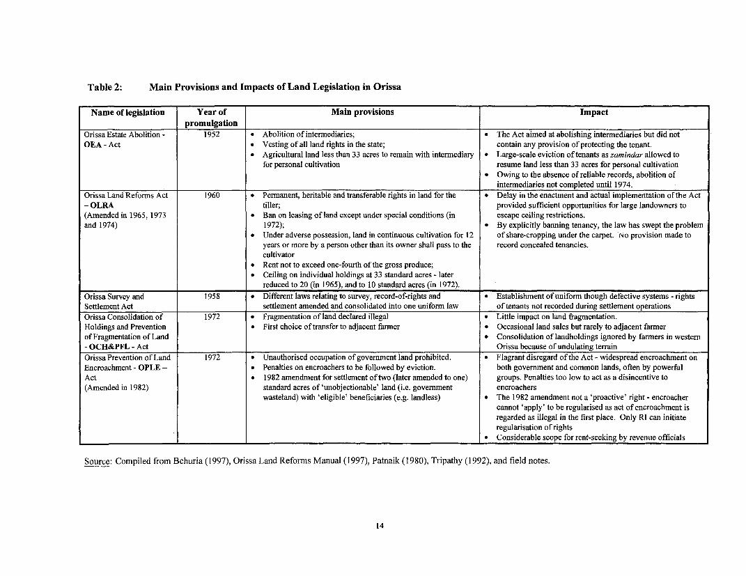
Table 2: Main Provisions and Impacts of Land Legislation in Orissa
Name of legislation Year of Main provisions Impactpromulgation
Orissa Estate Abolition - 1952 * Abolition of intermediaries; * The Act aimed at abolishing intermediaries but did notOEA - Act * Vesting of all land rights in the state; contain any provision of protecting the tenant.
* Agricultural land less than 33 acres to remain with intermediary * Large-scale eviction of tenants as zamindar allowed tofor personal cultivation resume land less than 33 acres for personal cultivation
* Owing to the absence of reliable records, abolition ofintermediaries not completed until 1974.
Orissa Land Reforms Act 1960 * Permanent, heritable and transferable rights in land for the * Delay in the enactment and actual implementation of the Act- OLRA tiller; provided sufficient opportunities for large landowners to(Amended in 1965, 1973 * Ban on leasing of land except under special conditions (in escape ceiling restrictions.and 1974) 1972); * By explicitly banning tenancy, the law has swept the problem
* Under adverse possession, land in continuous cultivation for 12 of share-cropping under the carpet. No provision made toyears or more by a person other than its owner shall pass to the record concealed tenancies.cultivator
* Rent not to exceed one-fourth of the gross produce;* Ceiling on individual holdings at 33 standard acres - later
reduced to 20 (in 1965), and to 10 standard acres (in 1972).Orissa Survey and 1958 * Different laws relating to survey, record-of-rights and * Establishment of uniform though defective systems - rightsSettlement Act settlement amended and consolidated into one uniform law of tenants not recorded during settlement operationsOrissa Consolidation of 1972 * Fragmentation of land declared illegal * Little impact on land fragmentation.Holdings and Prevention * First choice of transfer to adjacent farmer * Occasional land sales but rarely to adjacent farmerof Fragmentation of Land * Consolidation of landholdings ignored by farmers in western- OCH&PFL - Act Orissa because of undulating terrainOrissa Prevention of Land 1972 * Unauthorised occupation of government land prohibited. * Flagrant disregard of the Act - widespread encroachment onEncroachment - OPLE - * Penalties on encroachers to be followed by eviction. both government and common lands, often by powerfulAct * 1982 amendment for settlement of two (later amended to one) groups. Penalties too low to act as a disincentive to(Amended in 1982) standard acres of 'unobjectionable' land (i.e. government encroachers
wasteland) with 'eligible' beneficiaries (e.g. landless) * The 1982 amendment not a 'proactive' right - encroachercannot 'apply' to be regularised as act of encroachment isregarded as illegal in the first place. Only RI can initiateregularisation of rights
* Considerable scope for rent-seeking by revenue officials
Source: Compiled from Behuria (1997), Orissa Land Reforms Manual (1997), Patnaik (1980), Tripathy (1992), and field notes.
14

the liberalization of the land-lease market remains an obstacle to the rapid enactment of this law. Theinitiative behind this unified land administration law is most welcome, since the complexity of the existinglegislative framework, inherited as it is from diverse pieces of legislation designed to bring together quitedifferent revenue systems, accounts for much of the wide scope for evasion of the law in practice.
2.4 Women's access to land
The survey of the legislative framework in Orissa confirms that 'land reform policies have been based on theprinciple of redistributive justice and on arguments regarding efficiency (land to the tiller, fixation of ceilings,prevention of fragmentation, etc.); but on neither count are gender inequalities taken into account' (Agarwal,1994: 216). No law has dealt specifically with increasing women's access to land. Rights to land for Hinduwomen are according to the Hindu Succession Act 1956 which provides for daughters, widow and mother of aHindu man dying intestate to inherit property equally with his sons. In practice, however, significant andpersistent gaps exist between women's legal rights and their actual ownership of land, and between the limitedownership rights women do enjoy and their effective control over land (Agarwal 1994).
For example, the Orissa Land Reforms Act 1960 does not mention the order of devolution at all. So whetherthe devolution of tenancy land will be according to personal law, or would follow a different order ofdevolution, is open to interpretation. Gender inequalities in OLRA have also arisen from enactments relatingto the fixation of ceilings6 on two counts, namely:
* the definition of 'family': Article 37 of the Act defines a family as the individual and his/her spouse andtheir children, whether major or minor. Later the law was amended to include married daughters whereas achildless widow is not considered to be a member of her deceased husband's family (Orissa Land ReformsManual, 1997: A67-A69).
* recognising only men's and not women's independent land rights: Women's rights to land are mostoften subsumed under those of her husband. A woman does not count as an owner in her own right, whichleaves her disproportionately vulnerable to losing her land (See Box 4).
Box 4: Constraints on women's access to land
In a 1986 court case in Sambalpur, the govemment Revenue Officer, in assessing ceiling surplus land,aggregated the land of both spouses as 'family land', including land separately registered in the wife's nameand inherited from her father. But the Revenue Officer gave notice only to the husband as the 'personinterested'. The two men settled the matter between them, and the wife's land was declared surplus. The wifeappealed the order to the High Court, asking that her separate land be excluded from the ceiling surplus, on theground that since the land concerned was her separate property she was the 'person interested' to whom priornotice should have been given. This, she argued, would have given her a chance to ask the Revenue Officer tolet her retain her land and instead declare some part of her husband's land as surplus. Her appeal was acceptedby the High Court under the constitutional principle of 'natural justice.'
Source: All India Reporter (1986), 'Kunjalata Purohit v. Tahsildar, Sambalpur and others', Orissa 115,quoted in Agarwal (1994)
6 A ceiling is fixed in relation to a family unit consisting of up to five members. Additional land is allowed to be held byfamilies of over five members, subject to a specified maximum. OLRA, as amended in 1974, has fixed a ceiling of10 standard acres for a family of five which can increase by two standard acres for each member in excess of five,up to a maximum of 18 standard acres.
15

There is, however, a deeper issue of the perceptions of women's role in agriculture. This is reflected inSection 2 (21) of the OLRA by which 'persons under disability' refers to, inter alia, 'a widow, or an unmarriedwoman or a woman, who is divorced or separated from her husband ...'. On the face of it., this provision is aspecial consideration for female heads of households to lease out their lands for cultivation when leasing isotherwise prohibited. But it masks two important underlying presumptions: (i) that women are perceived to bein need of protection from the rigours of cultivation and so should be allowed to lease out their land; and (ii)that only female heads of households should have control over land, while for other married women livingwith their husbands control over land is subsumed under the 'family'. The first presumption ignores the factthat bulk of the agricultural tasks (especially labour-intensive tasks such as rice transplanting, weeding andharvesting) are, in any case, performed by women.
In some respects, the OLRA is quite progressive in that it allows land gifted to a daughter on the occasion ofher marriage to be excluded from the ceiling area of the father. Ostensibly, this is to encouLrage land transfersto daughters, but it rarely happens in practice. Generally, women do not have RORs in their own names. In afamily, the ROR is recorded in the name of the husband. Extensive discussions with women in Laderpally(Sambalpur district) and Badavema (Khurda district) villages reveals that women have RORs in their namesonly under special circumstances as described in Box 5. Women would very much like to hold the patta injoint names with their husbands to prevent indiscriminate land sale by husbands without their consultation7.Besides, in the event of a divorce, the wife would be able to claim a share of the joint property.
There was less unanimity, in both villages, on the issue of equal rights for sons and daughters. Women inLaderpally pointed out that equal rights for daughters will have a positive impact on the dowry problem. Veryoften parents have to sell off a piece of land to arrange for a dowry for the daughter. But even if the demandfor dowry is met, there is no guarantee that the daughter will be able 'to live happily after marriage'. In theevent that she is sent back to her parents on some trivial ground or other, the dowry would remain with her in-laws. Our respondents recounted the case of one family in Laderpally village that had sold half an acre of goodquality land for their daughter's dowry. Six months later, the daughter was sent back to her parents.Apparently, her husband and his parents did not like her. All the items given as dowry rermain with thehusband. "If we had given her a piece of land instead, my daughter would still have had it: with her", lamentedthe mother.
7 According to the ADM Sambalpur, joint pattas have begun to be issued in the joint names of husbands and -wives in twotehsils in the district on an experimental basis.
16

Box 5: When can women have lands registered in their own names?
* After the death of husband, wife becomes a joint share holder of the deceased's land, along with herchildren.
* If a family has more land than the ceiling set by the government, the surplus land is recorded in the name ofthe wife/daughter to avoid ceiling restrictions.
* When there is no male heir in the family, daughters get the ROR transferred to their names.* Unmaffied women (those who could not marry and are living with their parents/brothers) get some land in
their name. This does not come automatically, however, and often has to be contested.* There are cases in which a woman's in-laws transfer the ROR in their daughter-in-law's name, such as in
the event that an alcoholic man's parents believe that their son will sell off all their land.* In some cases, when a woman marries a widower or divorced man, her parents generally insist that the man
transfer some land in his new wife's name. This is done to ensure some economic security for the secondwife in case the man marries for a third time while the second wife is alive. Another reason is that anychildren the man may have by his first wife may might claim the entire property of the father leaving thesecond wife with no legal claim.
Women's legal rights in land conflict with deep-seated social norms and customs, and are rarely recognizedsocially to be legitimate. Thus, men are considered the defacto land owners even when the ROR is in thewife's name. For example, Janaki Panda of Badavema village (Khurda district) is the only daughter of herparents. She lives in her parent's house with her husband. After her father's death, her husband wasconsidered to be the household head even though she was the legal heir to her parental land. All majordecisions are taken by her husband.
While women would like to have an equal share in their parental land, they are aware of the culturalconstraints that are difficult to overcome. For instance, if a woman demands a share of her deceased father'sland, she often has to sever all relations with her brothers. There is usually a strong disincentive for manywomen not to press claims on parental property. This is because culturally a woman is not expected to claimany property from her parents/brothers. If she is unmarried and/or is in a financially tight situation, she mightget some land if the brothers are sympathetic and willing to share. Thus, there are strong pressures on womento cede their legal rights to their brothers, reinforced by social stigma, seclusion practices, and other sanctions.Given the lack of alternatives, women tend to be dependent on their brothers for economic and social supportin the event of widowhood or marital break-up.
Sections 2.3 and 2.4 have highlighted the consequences of the existing legal framework governing access toland for socially excluded groups. Various factors-have combined to frustrate the stated intentions of landreform legislation in Orissa. However, legal restrictions are only one part of the story. The other part relates tothe many formidable obstacles that constrain the poor (including women) from exercising even the limitedrights they currently have. Part of the explanation for this lies in the organisational structure and operationalprocedures of the state's land revenue department, which combine to create high transaction costs in landmarkets. The next section describes the structure of the land administration system in Orissa.
17
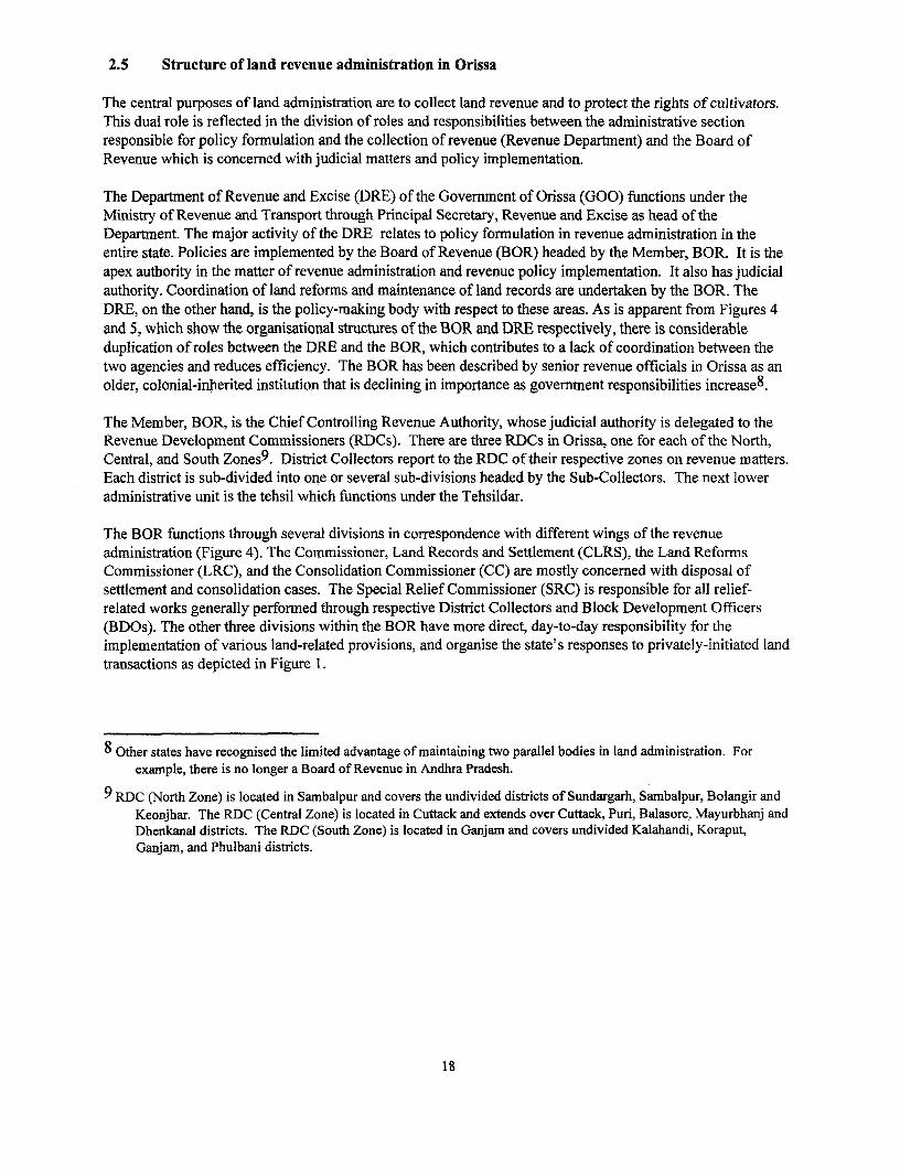
2.5 Structure of land revenue administration in Orissa
The central purposes of land administration are to collect land revenue and to protect the rights of cultivators.This dual role is reflected in the division of roles and responsibilities between the administrative sectionresponsible for policy formulation and the collection of revenue (Revenue Department) and the Board ofRevenue which is concerned with judicial matters and policy implementation.
The Department of Revenue and Excise (DRE) of the Govermnent of Orissa (GOO) functions under theMinistry of Revenue and Transport through Principal Secretary, Revenue and Excise as head of theDepartment. The major activity of the DRE relates to policy formulation in revenue administration in theentire state. Policies are implemented by the Board of Revenue (BOR) headed by the Member, BOR. It is theapex authority in the matter of revenue administration and revenue policy implementation. It also has judicialauthority. Coordination of land reforms and maintenance of land records are undertaken by the BOR. TheDRE, on the other hand, is the policy-making body with respect to these areas. As is apparent from Figures 4and 5, which show the organisational structures of the BOR and DRE respectively, there is considerableduplication of roles between the DRE and the BOR, which contributes to a lack of coordination between thetwo agencies and reduces efficiency. The BOR has been described by senior revenue officials in Orissa as anolder, colonial-inherited institution that is declining in importance as government responsibilities increase8.
The Member, BOR, is the Chief Controlling Revenue Authority, whose judicial authority is delegated to theRevenue Development Commissioners (RDCs). There are three RDCs in Orissa, one for each of the North,Central, and South Zones9. District Collectors report to the RDC of their respective zones on revenue matters.Each district is sub-divided into one or several sub-divisions headed by the Sub-Collectors. The next loweradministrative unit is the tehsil which functions under the Tehsildar.
The BOR functions through several divisions in correspondence with different wings of the revenueadministration (Figure 4). The Commissioner, Land Records and Settlement (CLRS), the Land ReformsCommissioner (LRC), and the Consolidation Commissioner (CC) are mostly concerned with disposal ofsettlement and consolidation cases. The Special Relief Commissioner (SRC) is responsible for all relief-related works generally performed through respective District Collectors and Block Development Officers(BDOs). The other three divisions within the BOR have more direct, day-to-day responsibility for theimplementation of various land-related provisions, and organise the state's responses to privately-initiated landtransactions as depicted in Figure 1.
8 Other states have recognised the limited advantage of maintaining two parallel bodies in land administration. Forexample, there is no longer a Board of Revenue in Andhra Pradesh.
9 RDC (North Zone) is located in Sambalpur and covers the undivided districts of Sundargarh, Sambalpur, Bolangir andKeonjhar. The RDC (Central Zone) is located in Cuttack and extends over Cuttack, Puri, Balasore, Mayurbhanj andDhenkanal districts. The RDC (South Zone) is located in Ganjain and covers undivided Kalahandi, Koraput,Ganjarn, and Phulbani districts.
18
I Ministry of Revenue and Transport L
Department of Revenue and Excise Ecs
I .
~~~~~~~~~~~~~~~r Diecor Cmmissioner, ' rDC RDC RDC Landissionrds Director, Commissioner IGR-cumn- Commissioner Ln eod omsinr
(Nort) (Central) (South) and Settlements Consolidation Special Relief EComissoe r Land Reforms and Survcys Operations
District Collector Consolidation Registrar Supdt.le n SOfficer Settlement | |Survey and|Officer officer Map Publ.
Office
District
Sub-Collector Sub-registrar
Asst. Charge
Consolidation OfchargOfficer Officer
Tahsildar Sub-registrar
| Assistant Settlement Officer
Revenue Inspector
Figure 4: Organizational Chart of Revenue Administration in Orissa
19
Survey and settlement: Rather than responding to any specific land transaction, the survey and settlementprocess recognises all land transfers that have occurred since the previous revisional survey but remainunrecorded for various reasons. The Director, Land Records and Survey (DLRS) is the nodal officerresponsible monitoring the survey and settlement operations and preparation of an up-to-date Record of Rights(ROR). Survey and settlement operations are organised through Settlement Officers in charge of respectivesettlement zones (with each zone covering several districts), and Charge Officers covering a 'range' or 'circle'across more than one district.
Land registration: The government's response to current land transfers1I is organised by the InspectorGeneral of Registration-cum-Excise Commissioner (IGR) who deals with registration and excise mattersthrough District Registrars/Sub-Registrars and Excise Superintendents. All policy matters relating toregistration administration and stamp duty are submitted by the IGR to the Government. Under section 69 ofthe Registration Act, the IGR is responsible for general supervision over all registration offices in the state andshall have the power from time to time to make rules consistent with the Act. Three Deputy IGRs are in chargeof the ranges: Northern Range at Sambalpur, Central Range at Cuttack, and Southern Range at Berhampur.They have the power to inspect all registration offices falling within their ranges. At the district level, theDistrict Registrar is empowered under section 68 of the Registration Act to supervise the sub-registrars underhim. The ADM (General) usually functions as the District Registrar with the support of a District Sub-Registrar. There are 144 sub-registration offices in Orissa. The Sub-Registrars, District Sub-Registrars andDeputy IGRs have been deemed to act in place of the Collector for the disposal of under-valuation casesunder section 2(9) of the Stamp Act.
Land consolidation: The Director, Consolidation controls and monitors land consolidation operations in thestate. The field units of the consolidation division are organised in a similar manner to the settlement divisionwith Consolidation Officer (for a zone) and Assistant Consolidation Officers (for ranges within a zone).
In the field, the District Collector (DC) is the superior authority for revenue administration in the district, andthe district-level officers of different divisions of the BOR (e.g. the Assistant Settlement Officer, AssistantConsolidation Officer and the District Registrar) report to the DC on administrative issues. However, the BORalso has a judicial role which is exercised through these field officers. Thus, the latter report to the RDC oftheir respective zones on judicial matters. The District Collector supervises the Sub-collectors (at the block-level), Tehsildars (in charge of a tehsil) and the Revenue Inspectors (RIs, or patwaris) who cover a number ofvillages within the revenue circle.
10 For present purposes, land transfers refer to transfers through sale, gift, and inheritance.
20

Principal Secretary,Department of Revenue and Excise
Personnel Settlement & Land Reforms Land Government Relief ExciseConsolidation Acquisition Estates (Natural calamities)
LandRecords
Figure 5: Organizational Structure of Department of Revenue and Excise
21
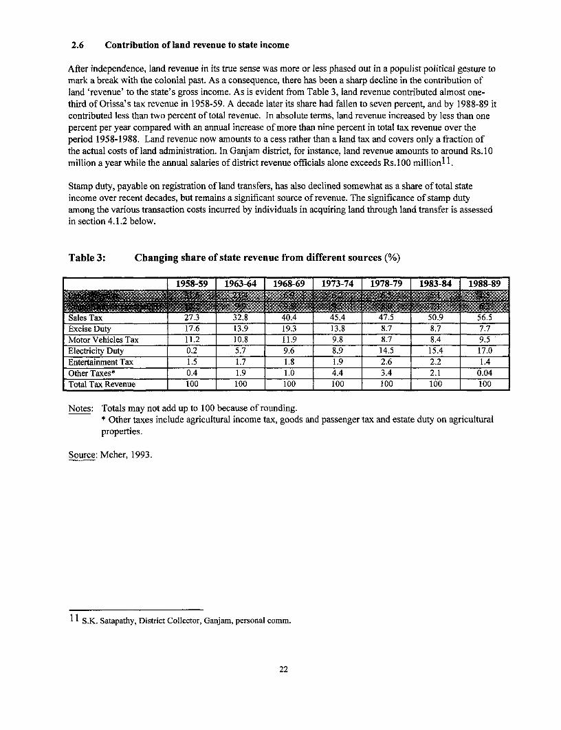
2.6 Contribution of land revenue to state income
After independence, land revenue in its true sense was more or less phased out in a populist political gesture tomark a break with the colonial past. As a consequence, there has been a sharp decline in the contribution ofland 'revenue' to the state's gross income. As is evident from Table 3, land revenue contributed almost one-third of Orissa's tax revenue in 1958-59. A decade later its share had fallen to seven percent, and by 1988-89 itcontributed less than two percent of total revenue. In absolute terms, land revenue increased by less than onepercent per year compared with an annual increase of more than nine percent in total tax revenue over theperiod 1958-1988. Land revenue now amounts to a cess rather than a land tax and covers only a fraction ofthe actual costs of land administration. In Ganjam district, for instance, land revenue amounts to around Rs. 10million a year while the annual salaries of district revenue officials alone exceeds Rs. 100 million I 1 .
Stamp duty, payable on registration of land transfers, has also declined somewhat as a share of total stateincome over recent decades, but remains a significant source of revenue. The significance of stamp dutyamong the various transaction costs incurred by individuals in acquiring land through land transfer is assessedin section 4.1.2 below.
Table 3: Changing share of state revenue from different sources (%)
11958-59 11963-64 1968-69 11973-74 1978-79 1983-84 1988-89
Sales TVax 27.3 32.8 40.4 45.4 47.5 50.9 56.5Excise Duty 17.6 13.9 19.3 13.8 8.7 8.7 7.7Motor Vehicles Tax 11.2 10.8 I11.9 9.8 8.7 8.4 9.5Electricity Duty 0.2 5.7 9.6 8.9 14.5 15.4 17.0Entertainment Tax 1.5 1.7 1.8 1.9 2.6 2.2 1.4Other Taxes* 0.4 1.9 1.0 4.4 3.4 2.1 0.04Total Tax Revenue 100 100 100 100 100 100 100
Notes: Totals may not add up to 100 because of rounding.* Other taxes include agricultural income tax, goods and passenger tax and estate duty on agriculturalproperties.
Source: Meher, 1993.
l S.K. Satapathy, District Collector, Ganjam, personal comm.
22
3. LAND SURVEY AND SETTLEMENT OPERATIONS
Land revenue is a rent fixed on land on the basis of its productivity and income. Land 'settlement' in Indianrevenue parlance refers to the assessment of the land revenue demand from each parcel (plot) of land. It ispreceded by:
* cadastral survey: a comprehensive survey of plot boundaries conducted upon both the initial formation ofthe plot (e.g. through partitioning) and any subsequent boundary changes; and
* preparation of Records-of-Rights (ROR): the ROR makes clear all interests in the land. The ROR does notalter existing rights or create new ones, but merely ascertains existing rights in a particular land parcel, andby whom they are exercised.
The survey and the ROR are together used to assess the land revenue.
Prior to Independence in 1947, different principles of rent settlement were followed in different parts ofOrissa. The Survey and Settlement Act, 1958 (followed by the Survey and Settlement Rules, 1962) introduceduniform procedures for survey, preparation of RORs and settlement of rent. The term 'settlement' will be usedhere to refer collectively to these three processes. Settlement is initiated by government in order to update theRORs before determining the land revenue demand. It usually takes place once every 20-25 years although insome places the frequency has been much lower. The settlement operation is organised through field camps12
at which officers from the settlement section camp are physically based for much of the duration of the surveyand settlement operation. Each camp covers a number of villages within the jurisdiction of a particular policestation. The notification for a camp is issued by the beat of drum and by posting a copy to the gram panchayatand the RI. A minimum notice of 2-3 months is given prior to setting up the camp at a prominent place in thevillage. For instance, the settlement camp in Badavema village in Khurda district, one of the 7 campsoperating simultaneously in Begunia Police Station at the time of our field study, covered 19 villages inBegunia RI circle, and had hired out part of the gram panchayat building.
The survey and settlement operation consists of three main stages: cadastral survey, preparation or updating ofland records, and assessment of revenue demand. Each of these is considered in turn.
3.1 Cadastral Survey
An essential preliminary step to settlement of land revenue is the preparation of a cadastral map of the village.First, trijunctions of survey fields are demarcated with stones and used for theodolite traverses. The ownersare notified and ordered to demonstrate their claims on the land to the amin by indicating where boundarieshave changed through mutation. In the event of a boundary dispute (e.g. by encroachment), the disputedportion of the plot is shown as representing a new, discrete plot, and remains legally registered in name of theoriginal ownerl3.
12 Technically, the settlement camp is known as the Attestation, Draft Publication and Objection Hearing (ADP & OH)camp.
13 To do otherwise would favor the encroacher and therefore give rise to considerable litigation. In practice suchinstances of encroachment do not come to the attention of the revenue authorities since they are referred to the civilcourt, which is prohibitively expensive for most people. In this process, weaker and disadvantaged land holdersoften lose effective control over land which remains legally registered as theirs.
23

Fields are then measured by means of chaining and orthogonal offsetting. A separate sketch is made for eachsurvey field. Plot boundaries within the survey field are also surveyed I4. After the map has been completed,the survey fields are numbered and the individual plots given sub-numbers. In the past, alleged changes inplot boundaries were physically marked on the ground, but this practice gave rise to so much litigation thatplot areas and boundaries are now simply compared with those shown on the previous map. This is alsopossible because most areas have been surveyed at least once and so previous maps exist.
Amins are responsible for plot-to-plot mapping. They follow 'The Technical Rules of the SettlementDepartment of Bihar and Orissa', 1927. The rules specify the instruments to be used and procedures to befollowed in the field. Survey instruments and procedures have changed little over the last 70 years, and are infact based on those developed by Todormal (Emperor Akbar's Finance Minister during the mid-16th century).
In recent years, the use of aerial survey methods has become more widespread in India1 5. In Orissa, however,the scheme for conducting aerial surveys is at a preliminary stage. A pilot project has been initiated in Anguldistrict, in collaboration with the Research and Development Wing of the Survey of India, but progress hasreportedly been slow due to the lack of efficient plotter equipment.
3.2 Preparation of the RORs
After the village survey, the actual boundary of each individual plot is determined (kistwar), and plot-wiseinformation16 provided in the prescribed format (khanapuri). The preliminary ROR (yaddast) is verified andvalidated in consultation with the landowner(s) (bhujarat and attestation). Draft khatiyans (the individualRORs) are then prepared and objections are invited (within a maximum of 60 working days) from concernedpeople for necessary amendments to the records (draft publication and objection hearing). In case ofobjections, the amin makes enquiries. On receipt of the amin's report, the Assistant Settlement Officer fixes asuitable hearing date. The records are amended after the objections have been settled. Box 6 provides a briefdescription of the nature of objections at a typical settlement camp.
3.3 Settlement of rent
The amended records are brought to the Settlement Office for rent assessment according to the government'srent policy (rent fixation). This is followed by the preparation of the final ROR for the village, includingrelevant details from each landholder's final khatiyan. Four copies of the khatiyan are produced fordistribution to the landholder(s), tehsil office (to regularly update any changes and record through subsequent
14 Broadly, two types of survey methods are used: the 'plane table survey' conducted by the Settlement Office for planesurfaces/ level ground, and the 'traverse survey' conducted by the Survey and Map Publication Office for hillyareas, rivers and forests. Survey and Map Publication Office is a constituent part of the Directorate of Land Recordsand Surveys (see Figure 4).
15 The usefulness of aerial survey methods depends upon topography, vegetation cover and the types of plot boundaries.Hilly areas may require more sophisticated and expensive photogrammetric methods that eliminate errors due toaltitude differences. Heavy vegetation cover may make certain boundaries invisible, making it necessary to at leastsupplement the aerial photography with a ground survey. In general, the use of aerial survey is most advantageousin open country with small, irregular fields having physical boundaries. Aerial survey is most feasible in rural areaswith large, regular fields having physical boundaries (Hanstad, 1996).
16 Such as land owner(s), forms of land rights, land use types, actual area of each plot belonging to the land owner,lease/mutation/encroachment details, and other relevant details. This is primarily a fiscal record to show from whomthe assessment of each holding is to be realised, and the amount.
24
mutations following land transfers), Collector's office, and the Revenue Inspector (finalpublication andpattadistribution). After the final publication of the RORs, the field maps are prepared at the Settlement Office toindicate the exact shape of individual plots within the village.
Box 6: Nature of objections at a settlement camp
At the camp in Badavema village, Khurda district, more than 70 percent of objections related to non-recordingof mutations for transferx deeds (sales and partition). About 20 percent arose out of errors during demarcation.Inheritance (3 percent), change of land title (3 percent) and land classification (1 percent) made up the rest ofthe objections. About 15 percent of objections relating to inheritance were brought by married women whohad been denied a share in their deceased father's property by their brothers.
Nearly one-third of the total number of objections were disallowed. This is a special category which relates toencroachment on government land. The encroaching parties have no patta (documentary evidence of landrights, i.e. sale deed or title) and the objection is thrown out. An Encroachment Register is prepared by thesettlement staff which records encroachment on cultivable or non-cultivable government land (grazing land,burial grounds, etc.). It is handed over to the tehsildar to pursue under OPLE.
The disallowed category also includes cases in which, after filing the initial objection, the concerned party failsto pursue their claim. Such cases arise most often over jointly-held property where the opposing claimants arebrothers who later resolve the dispute by agreement. However, once an objection is filed, it cannot bewithdrawn. It has to be investigated by the amin by interviewing witnesses near the plot. Women are rarelyinterviewed as witnesses.
Settlement officials claim that objections usually arise out of oversight on about 10-11 percent of the caseshandled by the settlement camp. Focus-group discussions with villagers in Badavema village reveals analtogether different picture. Their perceptions are summarised in Box 7.
At any given time, settlement operation take place in about 4,000 of the approximately 55,000 villages inOrissa. Revisional surveys may be thought of as a stock-taking exercise. In a single operation spanning over5-7 years, the area is re-surveyed, all land records updated, and land revenue reassessed for a number ofvillages within the circle of a police station. Settlement department officials perceive their role as providing a'door-step service free of charge' to the villagers as the latter are spared the effort of going to the sub-registrar's office, paying stamp duty and all other, unofficial transaction costs required to register the saledeed, and can have their rights recorded immediately in ROR on presentation of the sale deed without havingto apply for mutation. That is, settlement combines the registration of deeds (discussed in section 4.1.1) withthe issuingof land title (mutation) (discussed in section 4.1.2). Consequently, many land purchasers prefer towait for the settlement operation to register the transaction.
At the same time, the settlement operation:
* is inefficient and slow - takes 5-7 years to complete settlement in 15-20 villages, and may not be revisedfor a further 30 years. In Digpandhi, Ganjam district, one recently completed settlement operation wasconducted some 50 years after the previous settlement operation;
* provides an opportunity for rent-seeking - by government officials who perceive themselves as providing aservice which commands a price;
25

* is prone to manipulation by powerful interests - it is common for people to encroach on private (orcommon) land during settlement camps in order to have a larger area recorded in their names; or to attemptto influence settlement officers to show a larger area on the village map. Settlement operations often resultin increasing landlessness for the poor since it is easy for the more powerful to buy off settlement officersin their favour, leading to dispossession of poorer and weaker groups; and
* is likely to become irrelevant with computerisation - settlement operations will become unnecessary if themutation system is improved to as to permit regular and more rapid updating of land records (section4.1.3).
These shortcomings raise serious doubts as to the need to persist with settlement operations which might haveoutlived their utility. Some of these shortcomings and their distributional impacts are highlighted in a casestudy of farmers' experiences in Khurda and Ganjam districts in Box 7.
3.4 Conclusion
Land settlement is a carry-over from the British period when its main purpose was revenue assessment at whatwere then lucrative levels for the colonial administration. Under zamindari tenure, in which single proprietorspossessed large estates, the State revenue was assessed on the ascertained or assumed rental value. Therevenue, though fixed with reference to acreage rates on the land actually cultivated, was assessed on, andpayable by, the estate as a whole. The assessment remained unchanged for the period of the settlement. Theproprietor could bring as much of the wasteland under cultivation as desired, and it was only on re-assessmentat the end of the term of the settlement that the state could obtain any increase of revenue on account of theextensions of cultivation during the settlement period. The regular practice of revenue assessment, updatingand maintenance of land records were absent in the zamindari tracts since the tenants and sub-tenants were'tenants-at-will' and as such had no heritable or transferable rights in land. By contrast, land revenueadministration systems in khasmahal and ryotwari tracts were in much better shape.
Periodic settlement operations were the most cost-effective way of settling a large area in a short time. Therewas little need for sporadic settlements because land was rarely transferred or partitioned17. Moreover,settlement made sense when new lands were being brought under cultivation, i.e. without any transfer ofownership. The survey and settlement process may have outlived its utility is the same work can be done moreefficiently by a smoothly functioning registration and mutation process. The system of deeds registration isexamined in the next section.
17 This is not to suggest that land sales markets were absent during the late 19th and early 20th centuries. There wereseveral classes of tenancies in zamindari areas (especially privileged tenancies based on service) that were heritable.Rent-collection contracts were also bought and sold (K.C. Shivaramakrishnan, personal comm.).
26

Box 7: 'They knock on your door to collect bribes'
Farmers' main problems during survey and settlement operations relate to the rampant rent-seeking bygovernment officers and the manipulation of the process by the large landowners to their own advantage.Objections are invited to correct any mistakes that might have occurred during the preparation of the yaddastand the draft khatiyans. This is the primary stage of rent-seeking by officials at the settlement camp. The twocommon types of errors are that the land is shown in somebody else's name, and that the area recorded (e.g.0.75 acre) is smaller than the actual area owned (e.g. 1 acre).
A sum of around Rs. 500-1,000 is usually demanded to correct the mistakes. Landowners are convinced thatmistakes are made on purpose. For, "if these are genuine mistakes, why do they demand money to correctthem?"
Manipulation of the process by the large landowners emerged as a major issue in focus group discussions withlandowners in Digpandhi tehsil, Ganjam district. Numerous instances were reported of alterations being madeduring the preparation of the preliminary RORs owing to the influence of large (and perhaps literate) farmersover settlement officers.
In spite of these problems, landowners still prefer the settlement operation to mutation through the tehsil officesince they find settlement procedures to be less cumbersome. They report that with settlement, at least 'there isa single-window for bribes'; 'you don 't have to make repeated trips to the tehsil office ', 'you save on transportcosts and don't lose the daily wage'.
It is widely acknowledged that government services were generally not performed without paying a bit extra.An elderly landowner in Badaverna village, Khurda district, explained the difference between settlement andregular mutation as follows: 'during a settlement operation they come to your door to collect bribes, whereasfor ... mutation you have to go to the tehsil office to pay bribes.. and.. at the end of the settlement process (5-7years) you can be sure that your work will be done if you have paid the money.' He cited the case of onefarmer who has been unsuccessful in getting patta to a plot of land he bought 12 years ago even though he hadmade repeated trips to the tehsil office. It seems the previous RI was not sufficiently 'happy' and so some ofthe papers have now gone missing.
Ideally, people would prefer to get the ROR at the time of registration of the sale deed.
27
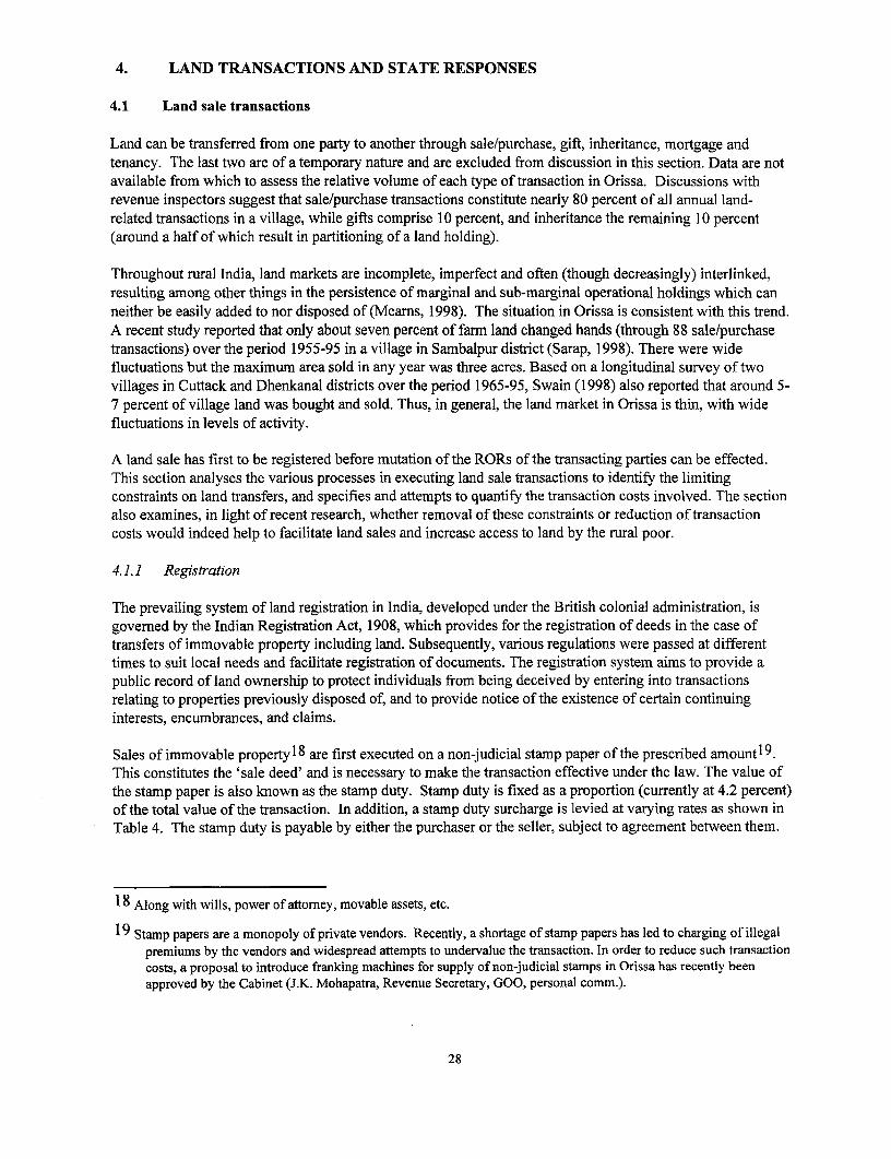
4. LAND TRANSACTIONS AND STATE RESPONSES
4.1 Land sale transactions
Land can be transferred from one party to another through sale/purchase, gift, inheritance, mortgage andtenancy. The last two are of a temporary nature and are excluded from discussion in this section. Data are notavailable from which to assess the relative volume of each type of transaction in Orissa. Discussions withrevenue inspectors suggest that sale/purchase transactions constitute nearly 80 percent of all annual land-related transactions in a village, while gifts comprise 10 percent, and inheritance the remaining 10 percent(around a half of which result in partitioning of a land holding).
Throughout rural India, land markets are incomplete, imperfect and often (though decreasingly) interlinked,resulting among other things in the persistence of marginal and sub-marginal operational holdings which canneither be easily added to nor disposed of (Meams, 1998). The situation in Orissa is consistent with this trend.A recent study reported that only about seven percent of farm land changed hands (through 88 sale/purchasetransactions) over the period 1955-95 in a village in Sambalpur district (Sarap, 1998). There were widefluctuations but the maximum area sold in any year was three acres. Based on a longitudinal survey of twovillages in Cuttack and Dhenkanal districts over the period 1965-95, Swain (1998) also reported that around 5-7 percent of village land was bought and sold. Thus, in general, the land market in Orissa is thin, with widefluctuations in levels of activity.
A land sale has first to be registered before mutation of the RORs of the transacting parties can be effected.This section analyses the various processes in executing land sale transactions to identify the limitingconstraints on land transfers, and specifies and attempts to quantify the transaction costs involved. The sectionalso examines, in light of recent research, whether removal of these constraints or reduction of transactioncosts would indeed help to facilitate land sales and increase access to land by the rural poor.
4.1.1 Registration
The prevailing system of land registration in India, developed under the British colonial administration, isgoverned by the Indian Registration Act, 1908, which provides for the registration of deeds in the case oftransfers of immovable property including land. Subsequently, various regulations were passed at differenttimes to suit local needs and facilitate registration of documents. The registration system aims to provide apublic record of land ownership to protect individuals from being deceived by entering into transactionsrelating to properties previously disposed of, and to provide notice of the existence of certain continuinginterests, encumbrances, and claims.
Sales of immovable property18 are first executed on a non-judicial stamp paper of the prescribed amount19 .This constitutes the 'sale deed' and is necessary to make the transaction effective under the law. The value ofthe stamp paper is also known as the stamp duty. Stamp duty is fixed as a proportion (currently at 4.2 percent)of the total value of the transaction. In addition, a stamp duty surcharge is levied at varying rates as shown inTable 4. The stamp duty is payable by either the purchaser or the seller, subject to agreement between them.
18 Along with wills, power of attorney, movable assets, etc.
19 Stamp papers are a monopoly of private vendors. Recently, a shortage of stamp papers has led to charging of illegalpremiums by the vendors and widespread attempts to undervalue the transaction. In order to reduce such transactioncosts, a proposal to introduce franking machines for supply of non-judicial stamps in Orissa has recently beenapproved by the Cabinet (J.K. Mohapatra, Revenue Secretary, GOO, personal comm.).
28

The original sale deed and a photocopy are produced before the district sub-registrar at the district-level, andthe sub-registrar at the tehsil level, for registration. The clerk compares the photocopy with the original andattaches a certificate. The purchaser then deposits the registration fee (2 percent of the value of thetransaction) and is expected to collect the registered document at a later date. However, such registration isvoluntary and the validity of the sale deed is not the concern of the registering officer. It is estimated thatabout 10 percent of all registrations are illegal, in which government land or land belonging to someone otherthan the vendor is sold to unsuspecting purchasers. Such cases tend to he in urban areas where informationasymmetries are high. In the rural areas, land is almost always inva1 jably bought and sold within a village inwhich people know each other20.
The value of the property sold/purchased is verified (from a valuation register) at the time of registration toascertain that it is not below the current market price. The highest value at which a particular type of propertyin a particular area is registered in the last three years constitutes the present market value of that property.This verification is necessary to prevent under-valuation, and thereby depresses the future 'market' rate2 1.
Other activities of the sub-registrar's office include:
Preservation of document copies: Four types of registers are maintained at the registration offices: Book 1contains the certified photocopies of documents relating to immovable property. Book 3 is concerned withwills. Book 4 consists of documents dealing with the power of attorney, adoption of movable assets, etc. Book2 records all transactions that are disallowed by the registrar's office, for example, in the event that one of theparties is a minor, stamp duties and registration fees have not been paid, or the transaction falls outside thejurisdiction of the Indian Stamp Act, 1899.
Issue of encumbrance certificates: Persons keen to know encumbrances on a property over a given period oftime provide details of the property and the period for which information is required, and deposit the fee forthe search and preparation of the certificate. On receiving the request, the clerk searches the Index II register ofthe village in which the property is located for the required period.
Issue of certified copies: Persons requiring a certified copy of a document have to deposit search, inspectionand copying fees. Search is done on the Index register from which the preserved photocopy of the document islocated and copied manually onto stamp paper.
Back office activities: These include preparation of: (i) Indexes I and II to help search for the information forissuing encumbrance certificates and certified copies, (ii) valuation register which records information, forevery village, on date of registration, area and type of land, and its value, (iii) fee book which maintainsrecords of different types of fees collected such as registration fee, search fee, inspection fee, copying fee, andmiscellaneous fee like marriage fee and petition fee, and (iv) the monthly receipt and expenditure statement.
Stamp duty and registration fees are important sources of revenue for the state government. In 1988-89 (thelast year for which comparative data are available), income from stamp duty and registration fees togetherconstituted 6 percent of the state's revenue (Table 3). While its relative contribution to total state income hasdeclined from 10 percent in 1958-59, in absolute terms stamp duty and registration fees contributed nearlyRs.600 million to state income from various sources in 1997-98 (Table 5). This figure, however, does not
20 It is customary for the purchaser to invite the seller for a meal which can typically cost Rs. 500.
21 Gift transfers avoid stamp duty. So if land is being transferred between brothers, they would prefer to show it as a giftrather than as a sale to evade stamp duty. No stamp duty is payable in inheritance cases.
29
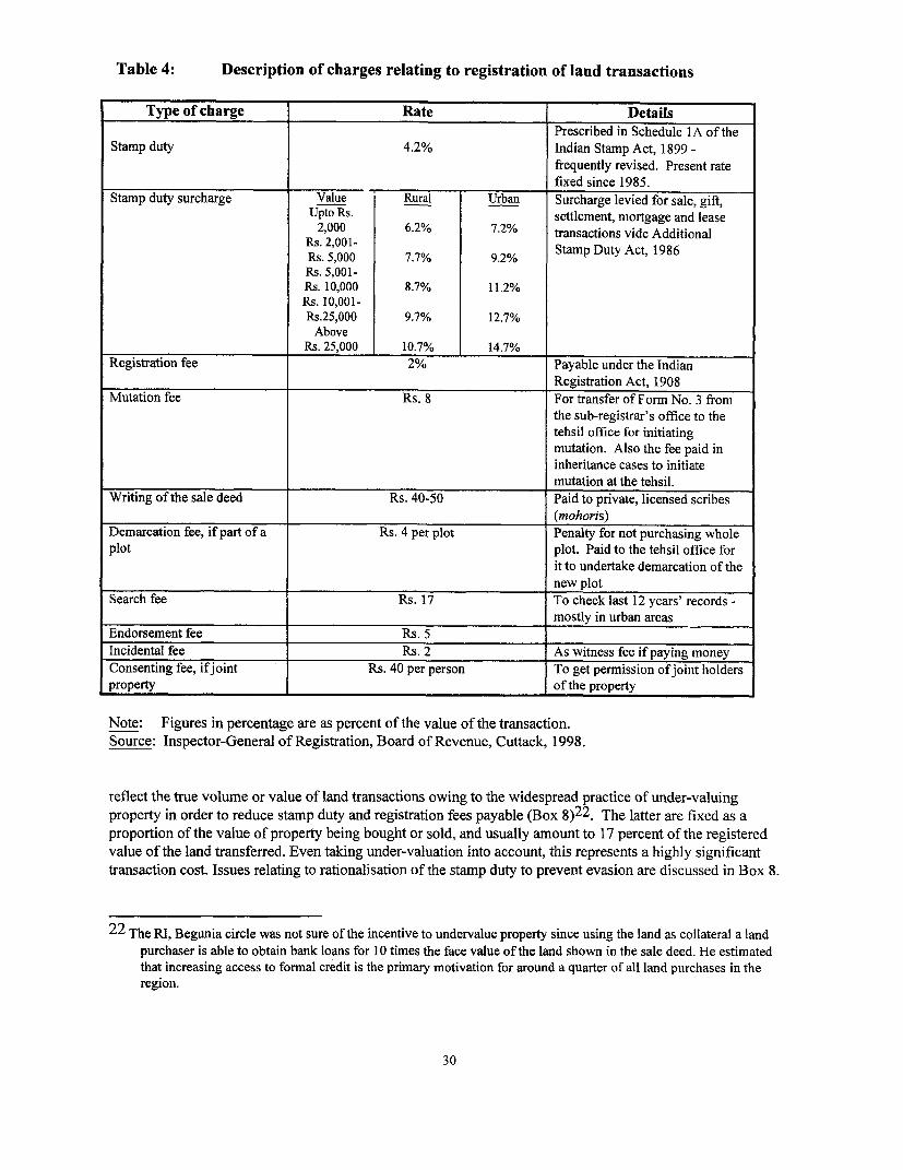
Table 4: Description of charges relating to registration of land transactions
Type of charge Rate DetailsPrescribed in Schedule IA of the
Stamp duty 4.2% Indian Stamp Act, 1899 -frequently revised. Present ratefixed since 1985.
Stamp duty surcharge Value Rural Urban Surcharge levied for sale, gift,Upto Rs. settlement, mortgage and lease
2,000 6.2% 7.2% transactions vide AdditionalRs. 2,001- Stamp Duty Act, 1986R.s. 5,000 7.7% 9.2%Rs. 5,001-Rs. 10,000 8.7% 11.2%Rs. 10,001-Rs.25,000 9.7% 12.7%Above
Rs. 25,000 10.7% 14.7%Registration fee 2% Payable under the Indian
Registration Act, 1908Mutation fee Rs. 8 For transfer of Form No. 3 from
the sub-registrar's office to thetehsil office for initiatingmutation. Also the fee paid ininheritance cases to initiate
____________________________________ mutation at the tehsil.Writing of the sale deed Rs. 40-50 Paid to private, licensed scribes
(mohoris)Demarcation fee, if part of a Rs. 4 per plot Penalty for not purchasing wholeplot plot. Paid to the tehsil office for
it to undertake demarcation of thenew plot
Search fee Rs. 17 To check last 12 years' records -________________________ __ mostly in urban areas
Endorsement fee Rs. 5Incidental fee Rs. 2 As witness fee if paying moneyConsenting fee, ifjoint Rs. 40 per person To get permission of joint holdersproperty l of the property
Note: Figures in percentage are as percent of the value of the transaction.Source: Inspector-General of Registration, Board of Revenue, Cuttack, 1998.
reflect the true volume or value of land transactions owing to the widespread practice of under-valuingproperty in order to reduce stamp duty and registration fees payable (Box 8)22. The latter are fixed as aproportion of the value of property being bought or sold, and usually amount to 17 percent of the registeredvalue of the land transferred. Even taking under-valuation into account, this represents a highly significanttransaction cost. Issues relating to rationalisation of the stamp duty to prevent evasion are discussed in Box 8.
22 The RI, Begunia circle was not sure of the incentive to undervalue property since using the land as collateral a landpurchaser is able to obtain bank loans for 10 times the face value of the land shown in the sale deed. He estimatedthat increasing access to formal credit is the primary motivation for around a quarter of all land purchases in theregion.
30
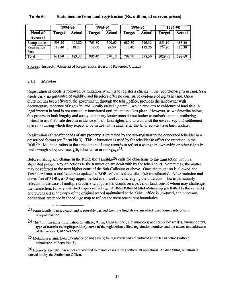
Table 5: State income from land registration (Rs. million, at current prices)
1994-95 1995-96 1996-97 1997-98Head of Target Actual Target Actual Target Actual Target ActualAccount
Stamp duties 503.50 401.80 763.80 500.60 687.50 566.30 855.10 488.30Registration 118.40 8150 132.60 89.50 112.40 112.20 174.80 110.30FeesITotal 621.90 483.30 896.40 590.10 799.90 678.50 1029.90 598.60
Source: Inspector-General of Registration, Board of Revenue, Cuttack
4.1.2 Mutation
Registration of deeds is followed by mutation, which is to register a change in the record-of-rights in land. Saledeeds carry no guarantee of validity, and therefore offer no conclusive evidence of rights in land. Oncemutation has been effected, the government, through the tehsil office, provides the landowner withdocumentary evidence of rights in land, locally called a patta2 3, which amounts to evidence of land title. Alegal interest in land is not created or transferred until mutation takes place. However, as we describe below,this process is both lengthy and costly, and many landowners do not bother to embark upon it, preferringinstead to use their sale deed as evidence of their land rights, and to wait until the next survey and settlementoperation during which they expect to be issued with apatta after the land records have been updated.
Registration of transfer deeds of any property is intimated by the sub-registrar to the concerned tehsildar in aprescribed format (on Form No.3). This information is used by the tehsildar to effect the mutation in theROR24. Mutation refers to the amendment of state records to reflect a change in ownership or other rights inland through sale/purchase, gift, inheritance or mortgage25.
Before making any change in the ROR, the Tehsildar26 calls for objections to the transaction within astipulated period. Any objections to the transaction are dealt with by the tehsil court. Sometimes, the mattermay be referred to the next higher court of the Sub-Collector or above. Once the mutation is allowed, theTehsildar issues a notification to update the RORs of the land transferor(s)! transferee(s). After mutation andcorrection of RORs, a 45-day appeal period is allowed for challenging the mutation. This is particularlyrelevant in the case of multiple brothers with potential claims on a parcel of land, one of whom may challengethe transaction. Finally, certified copies reflecting the latest status of land ownership are issued to the seller(s)and purchaser(s), the copy of the original record maintained at the Tehsil office is up-dated, and necessarycorrections are made in the village map to reflect the most recent plot boundaries.
23 Patta locally means a card, and is probably derived from the English system which used loose cards prior tocomputerisation.
24 The Form includes information on village, thana, khata number, plot number(s) and respective area(s), amount of rent,type of transfer (sale/gift/partition), name of the registration office, registration number, and the names and addressesof the vendor(s) and vendee(s).
25 Mutations arising from inheritance do not have to be registered and are initiated at the tehsil office (withoutsubmission of Form No. 3).
26 However, the tehsildar is not empowered to mutate cases during settlement operations. At such times, mutation iscarried out by the Settlement Officer.
31
The process of acquiring apatta after a land sale/purchase can take a minimum of 3 months if there are noobjections at any stage (Table 7). Typically, it takes 3-5 years and entails numerous trips to the tehsil office bythe purchaser. If for some reason the RI is not kept 'happy' by the purchaser it may take as long as 12 years(Box 8). Often the size of land parcel for which the patta is issued is less than the size of land parcel actuallypurchased. For instance, two brothers Ishwar and Ulla Gowda of Gopalpur, Ganjam district, purchased 2.12acres from Chanchala Pradhan. The patta records 2.06 acres even though they cultivate the full extent of the2.12 acre plot. Ishwar and Ulla Gowda fear that problems are likely to arise when they decide to sell the plot.The new purchaser would negotiate on the basis of the existing patta and pay for only 2.06 acres whileactually acquiring the full 2.12 acres.
Delays in processing, discrepancies, and rent-seeking seem to go hand in hand. It is argued by revenuedepartment officials that these are a consequence of the excessive work burden of the revenue inspectors andregistration clerks. This is discussed in the following section.
4.1.3 Land records management
Following land settlement and registration, the RORs and copy of the maps are supplied to the Tehsildar whois expected to maintain and regularly update them. However, it is commonly observed that the RI rarelycorrects the RORs on time, and mutation cases remain pending for many years, thereby severelycompromising the rights and interests of individual land holders.
Often inefficiencies arising from poor maintenance of RORs and the field maps increase transaction costs. It isargued that high transaction costs in sale and purchase of land place a disproportionately high burden on therural poor, and are likely further to depress the land sale market thereby reducing their access to private, arableland. This section examines whether rationalising the responsibilities of the RI and the tehsildar in the courseof the computerisation of land records and land registration would be likely to have a positive impact on theefficiency of land administration.
While the present system of land record management owes its origin to Todarmal, it was mainly developedunder British rule in the 19th century. The colonial administration relied almost entirely on revenue from landand so an efficient land records system was essential to its survival. However, regular updating of land recordswas rare. In zamindari areas, the intermediaries were only interested in collecting rent. For this part-time rent-collectors (e.g. guntia in Orissa) were hired and there was no systematic system for land records management.Most of the updating occurred during periodic settlement operations. A large proportion of Orissa's land areafell under zamindari tenure and so for all practical purposes, Orissa was a 'non-land record state'.
The need to improve and strengthen land revenue administration has long been recognised. As early as 1958,the poor state of land records was identified as one of the important causes of the failure of land reforms (GOI,1958). Thirty-five years later, the then Prime Minister remarked:
Many Chief Ministers have told me that even if they do not expect any money out of land revenue,they would like to see someone to keep the land records because it is a record of rights. If nobody hasa record of rights, might becomes right....Whether any land revenue is paid, whether that amount isconsiderable or not, whether that needs to be collected still or does not need to be collected, ... themaintenance of land records is a must and that has to be done. (Rao, 1992: 6-7)
However, constant reiteration in successive Five Year Plans of the need to improve and strengthen landrevenue administration and update land records has done little or nothing to arrest their neglect on the ground:
32
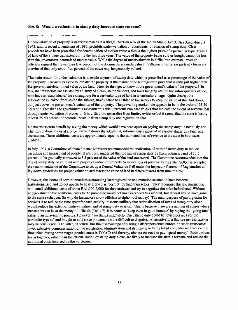
Box 8: Would a reduction in stamp duty increase state revenue?
Under-valuation of property is as widespread as it is illegal. Section 47A of the Indian Stamp Act (Orissa Amendment)1962, and its recent amendment of 1987, prohibits under-valuation of documents for evasion of stamp duty. Clearprocedures have been prescribed for determination of market value which is the highest price of a particular type (kisam)of land of the village transacted during the last three years. The value of the property being sold or bought cannot be lessthan the government-determined market value. While the degree of undervaluation is difficult to estimate, revenueofficials suggest that fewer than five percent of the documents are undervalued. Villagers in different parts of Orissa areconvinced that only about five percent of the cases may be genuinely valued.
The main reason for under-valuation is to evade payment of stamp duty which is prescribed as a percentage of the value ofthe property. Transactors agree to transfer the property at the market price but register a price that is only just higher thanthe government-determined value of the land. How do they get to know of the government's value of the property? Inthis, the transactors are assisted by an army of clerks, stamp vendors, and touts hanging around the sub-registrar's office,who have an exact idea of the existing rate for a particular type of land in a particular village. Quite clearly, theinformation is leaked from inside the sub-registrar's office to enable the transactors to keep the value of the land down,but just above the government's valuation of the property. The prevailing market rate appears to be in the order of 25-50percent higher than the government's assessment. Table 6 presents two case studies that indicate the extent of revenue lossthrough under-valuation of property. It is difficult to generalise from limited evidence but it seems that the state is losingat least 25-50 percent of potential revenue from stamp duty and registration fees.
Do the transactors benefit by saving the money which would have been spent on paying the stamp duty? Obviously not.The information comes at a price. Table 7 shows the additional, informal costs incurred at various stages of a land saletransaction. These additional costs are approximately equal to the estimated loss of revenue to the state in both cases(Table 6).
In July 1997, a Committee of State Finance Ministers recommended rationalisation of rates of stamp duty to reducehardships and harassment of people. It has been suggested that the rate of stamp duty be fixed within a band of 10.5percent to be gradually narrowed to 8.5 percent of the value of the land transacted. The Committee recommended that therate of stamp duty be coupled with proper valuation of property to reduce loss of revenue to the state. GOO has acceptedthe recommendation of the Committee to set up a Central Valuation Cell under the Inspector-General of Registration tolay down guidelines for proper valuation and assess the value of land in different areas from time to time.
However, the extent of corrupt practices surrounding land registration and mutation seemed to have becomeinstitutionalised and do not appear to be perceived as 'corrupt' by land transactors. They recognise that the transactionwill entail additional costs of about Rs.1,000-2,000 for the purchaser and try to negotiate the price beforehand. Withoutunder-valuation the additional costs to the purchaser would not have exceeded this amount, but at least would have goneto the state exchequer. So why do transactors allow officials to siphon-off money? The main purpose of paying extra forservices is to reduce the time spent for each activity. It seems unlikely that rationalisation of rates of stamp duty alonewould reduce the extent of undervaluation, and of stamp duty evasion. This is because there are a number of stages wheretransactors can be at the mercy of officials (Table 7). It is better to 'keep them in good humour' by paying the 'going rate'rather than delaying the process. However, two things might help. One, stamp duty could be levied per area for theparticular type of land bought or sold since plot area is more difficult to disguise. Alternatively, a flat rate per transactionmay be considered. The latter, of course, has the disadvantage of placing a disproportionate burden on small transactors.Two, extensive computerisation of the registration administration and its link-up with the tehsil computer will reduce thetime taken during some stages (shaded areas in Table 7) and thereby, obviate the need to pay 'speed money'. Both optionstaken together, rather than the rationalisation of stamp duty alone, are likely to increase the state's revenue and reduce theadditional costs incurred by the purchaser.
33
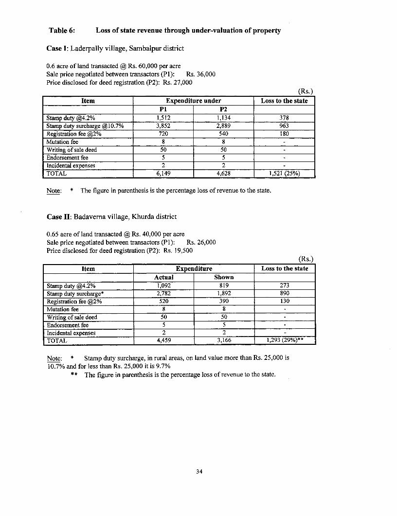
Table 6: Loss of state revenue through under-valuation of property
Case I: Laderpally village, Sambalpur district
0.6 acre of land transacted @ Rs. 60,000 per acreSale price negotiated between transactors (P1): Rs. 36,000Price disclosed for deed registration (P2): Rs. 27,000
(Rs.)Item Expenditure under Loss to the state
P1 P2Stamp duty @4.2% 1,512 1,134 378Stamp duty surcharge @10.7% 3,852 2,889 963Registration fee @2% 720 540 180Mutation fee 8 8Writing of sale deed 50 50Endorsement fee 5 5Incidental expenses 2 2TOTAL 6,149 4,628 1,521 (25%)
Note: * The figure in parenthesis is the percentage loss of revenue to the state.
Case II: Badaverna village, Khurda district
0.65 acre of land transacted @ Rs. 40,000 per acreSale price negotiated between transactors (P1): Rs. 26,000Price disclosed for deed registration (P2): Rs. 19,500
(Rs.)Item Expenditure Loss to the state
Actual ShownStamp duty @4.2% 1,092 819 273Stamp duty surcharge* 2,782 1,892 890Registration fee @2% 520 390 130Mutation fee 8 8Writing of sale deed 50 50 _
Endorsement fee 5 5Incidental expenses 2 2TOTAL 4,459 3,166 1,293 (29%)**
Note: * Stamp duty surcharge, in rural areas, on land value more than Rs. 25,000 is10.7% and for less than Rs. 25,000 it is 9.7%
** The figure in parenthesis is the percentage loss of revenue to the state.
34

Table 7: Additional transaction costs in the land market
Stage Step Person Approx. Additional costsinvolved time taken. ~~~~~~~ ~~~Approx. Purpose
. : ~~~~~~amount
REGISTRATION j
s : . r S \ = ......... . , . . 7 ~~T o undervalue theExecute Licensed price of land and bring
transaction on Vendor Neg. Rs. 50 it in line with thestamp paper prevailing government
REGISTRATION rate
Tehsildar invitesobjections to thesale on receipt ofForm No. 3 from Tehsildar 2 weeksMUTATION the registrar's
office
-Patia issued if Revenue 4 weeks Rs. 400-500 For speedy issuance ofno objections inspector the patta
- If objections Tehsildar 5 years* -
* If there are objections from, say, joint owners, a case is registered in the tehsildar's revenue court, in the firstinstance, for hearing and disposal.
Shaded rows indicate activities where computerisation might benefit the transacting agents by reducing theirtransaction costs.
Source: Compiled from field notes.
35

In states like.. Orissa.. there is no system of the annual revision of the record of rights. ..The records areusually brought up-to-date only during re-survey and settlement. As these operations are usually done at verylong intervals the records remain out of date most of the times (Appu, 1997: 102-3).
Poor land records often lead to:
* Difficulty in protecting land rights: Land records specify the rights of individuals and the state withrespect to a particular parcel of land. It is difficult to uphold rights if they are not recorded or updatedregularly.
* Difficulty in targeting development initiatives: An inefficient land records system makes it difficult toretrieve timely information for purposes of policy formulation and targeting of state benefits.
* Increase in rent-seeking: Lack of records restricts the flow of information and gives rise to economicrents that may be captured by government officials.
* Increase in rural/agrarian violence: While poor land records do not directly lead to agrarian violence,they contribute by making it difficult to enforce rights and target benefits to the poor.
* Encroachment of government land: Poor or partial maintenance of land records has led to the steadyencroachment of government land.
* Uncertainty in conveyancing. An imperfectly maintained land records system increases the costs of allland transactions and prevents the development of a freely functioning land market.
* Inability of landowners to access credit: Poor land records make it difficult to use land as a collateral toraise credit in both institutional and informal markets.
Various plan documents have recognised these factors, and a conference of revenue ministers on land reformsin 1985 reached a consensus that 'computerisation of land and crop-based statistics should be taken up on pilotbasis at tehsilVrevenue-circle level' (GOI, 1985:54). Computerisation of land records (COLR) is now beingimplemented to redress this shortcoming. It is hoped that it will:
* facilitate easy maintenance and updating of changes that occur in the land data base (e.g. changes due toavailability of irrigation, natural calamities, consolidation or on account of land transactions);
* make land records tamper-proof and indirectly reduce litigation and social conflicts over land;* facilitate implementation of development programmes for which data about distribution of landholding is
vital;* assist in planning for infrastructural and environmental development;* produce accurate records for land revenue purposes;* facilitate speedy retrieval of land-related data;* provide a database for the quinquennial agricultural census; and* issue updated copy of RORs to landholders quickly and more cheaply.
COLR is a central-sector scheme with full financial assistance from Government of India (GOI). Orissa is theonly state in the country in which the scheme is being implemented in all districts. A sum of around Rs. 300million has been made available by the GOI for three years to cover data entry in the local language (Oriya),civil construction, purchase of hardware, and operational costs during that period. GOO will take over fullresponsibility for the operation at the end of the three-year period.
The scheme is to be executed on a district-wise project basis through the Revenue department. Private firmshave been contracted to enter the records in 10 districts27 in the first instance. The target for data entry is 90
27 The districts are: Ganjam, Cuttack, Kendrapada, Jagatsinghpur, Bhadrak, Khurda, Bargarh, Dhenkanal, Angul, andNayagarh.
36
days per tehsil and work will be carried out simultaneously in all tehsils. Validation of information will beundertaken by the Board of Revenue staff while the data is being entered. But only data entry is to bechecked, not the RORs themselves. Training of tehsildars will take place in a phased manner. A computerisedland pass book will be provided to each individual landowner to maintain a proper account of landtransactions. This will also serve as documentary evidence of rights in land for such purposes as raisinginstitutional credit.
Since the project has only recently begun in Orissa it is too early to assess its possible impact. However,COLR was originally mooted during the Seventh Five-Year Plan and some projects were taken up in a fewstates as pilot projects during 1988-89 to 1991-92. Morena district in Madhya Pradesh was the first to becompleted as a pilot project in 1992. In spite of methodological limitations, a recent evaluation report ofCOLR in Morena (Sinha, 1998) concludes that the programme has:
* increased flow of information to the public through improved access to records and an increased awarenessof their rights, although this benefit has accrued more to those situated near district or tehsil headquarters;
* led to the emergence of the data-entry operator as a new rent-seeking agent;* been responsible for only a marginal reduction in the workload of the patwaris (revenue inspectors);* failed to reduce the rent-seeking behaviour of patwaris because they perform numerous functions besides
providing copies of the ROR that are unaffected by computerisation of land records, and because peopleare loathe to deny the RI (for possible favours in the future) what has now come to be regarded as his dueshare;
a not resulted in better implementation of land reforms;* not led to any significant improvements in land record management;* so far failed to facilitate land transfers; and* not led to any appreciable reduction in land disputes.
It should not be concluded from these findings that the computerisation of land records is ultimately likely toprove unsuccessful. Programme acceptance by all levels of the administration through increased utilisation ofthe database could increase its uptake in the future and increase effectiveness. The evaluation also suggeststhat the supply of computerised land records should be accompanied by a demand for the records from thefarmers.
This is likely to happen only when members of the public are aware of their rights, know how to accessinformnation, and know how to press their claims. Under an initiative of the current Revenue Secretary, a'User's Manual on Revenue Laws and Rights in Land' has been prepared in Oriya language in order to raisesuch awareness among land users. It is designed to be user-friendly and to provide simple information in a'Frequently Asked Questions' (FAQ) format, and will be distributed at a low price (about Rs. 10 per copy)through revenue offices, local panchayats, etc. About 25,000 copies are likely to be produced in the firstinstance.
Inefficiencies in land records management stem from a combination of factors, only some of whichcomputerisation is likely to help address. For example, it cannot reduce inaccuracies in the initial recording ofinterests in land. The now almost negligible contribution of land revenue to the state budget seems to havecontributed to the perception that it is not important to maintain accurate land records. While revenueinspectors continue to collect primary data and to represent the cutting edge of land administration, there hasbeen no addition to the local revenue staff (revenue inspectors, clerks, etc.) to cope with the increase in thevolume of work arising from the natural increases in population and land transactions, and no new investmentin infrastructure or staff training. Recent years have also witnessed a rapid increase in development work(such as digging bore-wells, installing bio-gas plants, meeting adult literacy targets, etc.) which is oftenhandled by the revenue staff. Taken together, these factors combine to over-burden the lower levels of the
37
revenue administration and results in an inefficient land record management system fraught by excessivedelays and high potential for rent-seeking. It is therefore important to examine the working conditions andworkload of RIs to identify areas for improved effectiveness.
Over the years the scope of Rls' operations has increased both in terms of the area covered and the number oftasks performed. On average, an RI circle in Orissa now covers 20-30 villages28 with an annual revenuedemand of about Rs. 200,000. This is nearly 10 times the figure prescribed in the 1961 'Manual of TehsilAccounts' in which an RI circle was envisaged to have a revenue demand of Rs. 20-25,000 and a tehsil was tocover an area with revenue demand of Rs. 300,000 (Tripathy, 1992). The conference of state revenuesecretaries in 1985 agreed that 'the areal jurisdiction of the [RI] should be brought down to a manageable levelsuch as four villages or 3000 khatiyans per [RI]' (GOI, 1985: 53). At the same conference, the revenueminister of Orissa acknowledged that 'revenue administration [in the state] is weak' (p. 15) and needs to berevamped.
The RI's primary function is collection of land revenue and maintaining land records. But he is alsoresponsible for a variety of other tasks. These tasks are grouped into four broad categories in Table 8, whichalso indicates the proportion of the RI's total working time likely to be devoted to each category, according tothe perceptions of the Rls interviewed. It is evident that computerisation is unlikely to reduce the time spentby RIs on the collection of land revenue and other dues, miscellaneous enquiries, issuing certificates orattending courts. Computerisation will, however, enable the RIs to concentrate on important matters such astimely submission of reports for disposal of cases, field visits, and correction of records.
While COLR is a positive development it should not be regarded as a panacea for improving landadministration. Its impact will only be maximised when:
* it is accompanied by rationalisation of the RI's workload and of the procedures of revenue administration.It may be appropriate to hire a management consultancy firm to undertake a systematic work-study of theRI. The terms of reference for such a study could include an assessment of the training needs and avenuesfor promotion of Rls and tehsildars, and decentralisation of some of the tasks;
* it becomes more widely used and different government departments use it to transfer information anddatabases. A computer link, for example, between the sub-registrar's office and the tehsil headquarterswould be of considerable benefit to agents transacting in land.
It is clear that the computerisation of land records and the computerisation of the land registration system haveto be undertaken simultaneously and effectively coordinated for transaction costs to be significantly reduced.A proposal to computerise the registration system in Orissa and integrate it 'backwards' into land recordsmanagement has been recently been sanctioned by the state government (see Box 9).
28 This is only an average; for example, there are 70 villages within Begunia RI circle, Khurda district.
38

Table 8: Scope of responsibilities of Revenue Inspectors
Collection of dues ti4= Issue certificates, Respond to*1 ~~attend courts miscellaneous enquiries
attendecourts from the Tehsildar40% 25% 10% 25%
December to March and , l The RI is expected to The RI is responsible forJune, is the collection 1~s,~~i' 1e~ s provide information to sending reports to theseason in which the RI l concerned departments Tehsildar on:camnps in particular on: . ceiling surplus casesvillages. In spite of * income, under the Orissa Landfocusing on the post- 0 ~ solvency, Reforms Act,harvest season when * caste status, * mutation cases wherecollection is likely to be a . - nationality, fraction plots areeasy, annual arrears is l . * residence, involved,around 15%. Half of the &. legal heir, u encroachment cases,amount is usually property valuation, lease of govermentpending for more than 3 ~ o~i~n> and lands,years. * professional status * property statements for
to relevant departments execution of attachmentof sa*rd ~for issue of certificates warrants in Certificate
~.~,..-'to people within the RI cases***,2111 | | circle. * fire accidents, and
y~i~ The RI also attends *naulhzrd
'7revenue or civil courts asand when necessary.
Sairat sources are those that are auctioned e.g. tanks, mines, etc.* Siha refers to the ledger of petty cash. Sadar siha is the ledger maintained for urban areas.
*** Certificate cases relate to late payment of dues.The shaded portion suggests the tasks which might benefit from computerisation of land records
Source: Compiled from field notes.
39

Box 9: Computer-aided Registration Administration System (CRAS)
The present registration system is manual and dependent upon age-old methods and procedures. Theincreasing volume of transactions has led to inordinate delays and inefficiencies. Further, documents aresubject to decay and the retrieval of documents is laborious and prone to delays. At the same time, valuationof property, essential to confirm that the sale price is not below the prevailing market price, takes a great dealof time in manually searching through the previous three years' records to find the highest value.
On the initiative of the Orissa Revenue Department, the state unit of the National Informatics Centre wascontracted to develop a proposal for the computerisation of the registration administration system (CRAS) andits backward integration with land records computerisation. CRAS is expected to:
* reduce scope for the manipulation of records, and the time required to complete registration;* eliminate the need for Form No.3, and thereby reduce delays, as information pertaining to land transaction
may be sent directly to the tehsil computer;* enable the sub-registrar to ascertain the validity of the transaction at the time of registration, by linking to
the tehsil computer, thereby reducing subsequent delays and unnecessary costs; and* assist the tehsildar at the time of mutation to ascertain relevant facts directly by means of a link to the sub-
registrar's computer for speedier disposal of mutation cases and updating of RORs.
Source: Natinal Informatics Centre, 1998
4.1.4 Will reduced transaction costs facilitate land sales and increase access to land by rural poor?
To address these questions, we first need to examine the functioning of the rural land market. Why do farmhouseholds buy or sell land? And, who buys and who sells?
It is conventionally assumed that the full specification and documentation (in the form of assured title) ofprivate rights in land will eliminate risks and uncertainty in land rights and will lead to an active land market.However, a characteristic feature of the rural land market in Orissa, and elsewhere in India, is that the demandfor land far exceeds its supply. This is usually because land ownership is one of the principal sources oflivelihood security in the villages. No one wants to sell land unless forced to, since
'land prices do not fully compensate for the high risks in parting with this secure asset as evaluated bythe farmer. In the absence of integrated financial markets, the transaction costs of investing the salesproceeds in alternative ventures is also far too high. Besides, the externalities of landownership interms of social status and credit collateral for the owner may not be fully reflected in the land prices inthe market.' (Bardhan, 1984: 95)
Land ownership is also a major source of prestige and social status. It is estimated that in urban areas ofOrissa, nearly 300,000 household heads, mostly employed by the government, each own more than three acresof land in their natal villages. They hold on to their holdings as absentee landlords for prestige2 9. Untilrecently, status in urban areas was usually derived not so much from the size of one's village holding, but fromthe fact that 'food (grain) comes from my village land.'
29 Member, Board of Revenue, Cuttack, personal comm.
40
A recent study on the operation of land markets in a village in Sambalpur revealed that about 70 percent ofland sales over the 40-year period 1955-95 were distress sales, i.e. for consumption and debt repayment,medical or marriage purposes, which are highly inelastic (Sarap, 1998). Land sale for investment purposesaccounted for between 20 and 33 percent of all transactions for marginal, small and medium farmers, but fornearly half of the land sale transactions of large farmers30. The investment expenditure of the former groupwas found to represent a form of distress diversification into low productivity, non-farm enterprises31 whichrequired small amounts of working capital. The large farmers, on the other hand, invested the proceeds fromthe sale of land in purchase of commercial vehicles, building construction, financing higher education, andfinding jobs for their children.
The research also showed that large farmers:
* purchased a larger area of land per transaction compared with other size classes of farmers, suggesting thatthey enjoyed more ready access to credit;
* often purchased productive land in the village, or plots situated near their present landholdings; and* purchased land from everyone - from other large farmers as well as from medium, small and marginal
farmers.
Swain (1998) reported similar findings on the operation of the land market from a comparative study of anagriculturally advanced and irrigated village in Cuttack district and an agriculturally backward village inDhenkanal district. All land transactions bar one in the advanced village were for distress purposes:consumption, marriage, loan repayment, replacement of dead bullocks, and funerals. One farmer sold off hisunirrigated holding to buy an irrigated plot. In the agriculturally backward village, two out of every three landsale transactions were for meeting the expense of a daughter's wedding.
These findings suggest that the land market is underdeveloped and sluggish across different parts of Orissa. Itis mostly driven by distress sales, as farmers are unwilling to part with their plots of land under normalconditions. And, it is the large farmers who are the dominant players in the land market, buying productive andbetter located lands and consolidating their holdings.
Discussion in this section suggests a general 'Principle of Joint Requirements' (Lipton, 1998: 4), if access toland for the rural poor is to be enhanced through the market. It seems that lowering the costs of transacting inthe land sale market alone may be unable to induce land sales, unless several requirements are met jointly. Thetotal rate payable for stamp duty and registration fees must be reduced. Land records and the registrationsystem need urgently to be computerised and the two systems integrated. The revenue inspector's workloadrequires a measure of rationalisation. But these steps will have to be accompanied by a number of additionalmeasures. Imperfections in the credit market need to be removed. Non-farm employment and investmentopportunities need to be increased. And there will also have to be improved access to education, health andskill formation, if reduced transaction costs are to facilitate land sales and lead to improved access to land bythe rural poor.
As first steps, GOO should focus on rationalising rate of stamp duty, coordinating the computerisation of landrecords and registration, and rationalising revenue inspectors' workload. These may not immediatelyencourage new sellers to enter the land market, but at least the existing transactors would be sparedconsiderable hardship and harassment.
30 Marginal: less than I acre, Small: I - 2.5 acres, Medium: 2.51 - 5 acres, and Large: above 5 acres.
31 E.g. small vegetable shops (in a portion of the house), paddy husking, or spices and vegetable marketing.
41
4.2. Land fragmentation
Agricultural holdings do not normally comprise a single compact block but are made up of a number of parcelsscattered across the village. The fragmentation32 of operational holdings into multiple plots is commonlyperceived to be a serious constraint on agricultural productivity. High direct and opportunity costs incultivation are frequently ascribed to fragmentation, including: the time and energy expended in moving labor,draft animals, seed, manure and irrigation water from one plot to another, and bringing harvested crops to acommon point; supervision of labor; increased expenses of irrigation and drainage; difficulty of access toscattered plots; and loss of land in boundaries (Mearns 1998).
State governments have attempted to control fragmentation through legislative means and by encouraging landconsolidation, or making it compulsory. This section examines the extent of fragmentation in Orissa, legalprovisions to control it, and progress achieved and problems encountered in the administrative process of landconsolidation.
4.2.1 Extent offragmentation
There is widespread consensus that the rate of fragmnentation of land holdings in Orissa is very high, thoughthe evidence is patchy. This is because there is no systematic compilation of data within the state on thenumber of parcels per operational holding. These data is collected at the time of consolidation operations, andmay even be sent to the Director, Consolidation at Cuttack. But they are rarely aggregated so as to form acomprehensive view of the extent of fragmentation, regional variation, or of the relative success ofconsolidation. Thus, much of this discussion is based on village studies, National Sample Survey (NSS) data,and informed estimates.
The trend in fragmentation over time and across land sizes is shown in Table 9. In 1961-62 there were anaverage of 6.4 fragments (or parcels) per operational holding across all size classes. By 1981-82, this hadfallen to 5 parcels per holding. The average area per parcel has also declined during this period, thoughmarginally, from 0.31 to 0.29 ha. It is evident that the rate of fragmentation is higher in medium and largeholdings.
In the absence of more disaggregated data, it is difficult to form an accurate view of regional variation infragmentation. Knowledgeable sources claim that fragmentation is a more serious problem in irrigated andcoastal areas than in western Orissa. However, and we discuss below, there is considerable resistance to landconsolidation in western Orissa.
32 Fragmentation is defined as the number of non-contiguous plots per operational or ownership holding within a village.
42

Table 9: Land fragmentation in Orissa by operational holding size
Size of operational 1961-62 1981-82holding (ha)
No. of parcels per Average area per No. of parcels per Average area perholding parcel (ha) holding parcel (ha)
0.00 1.560.002-0.20 2.19 0.03 1.28 0.050.21-0.40 3.52 0.08 3.98 0.070.41-1.00 4.60 0.14 4.53 0.151.01-2.02 6.08 0.23 6.24 0.242.03-3.03 8.32 0.28 6.66 0.373.04-4.04 9.92 0.34 7.17 0.484.05-5.05 10.64 0.42 7.58 0.595.06-6.07 9.91 0.53 9.10 0.606.08-8.09 12.59 0.53 9.19 0.728.10-10.12 11.08 0.80 9.23 0.9610.13-12.14 15.46 0.65 15.24 0.7012.15-20.24 10.58 1.53 8.50 1.67
20.25 and above 8.30 2.78 6.51 8.04All sizes 6.39 0.31 5.02 0.29
Source: Compiled from Thangaraj (1995).
4.2.2 Legal provisions and progress of land consolidation in Orissa
Consolidation of land holdings is designed to reverse fragmentation through a scheme of redistribution oflands in compact rectangular blocks3 3. The Orissa Consolidation of Holdings and Prevention ofFragmentation of Land (OCH & PFL) Act, 1972 aims to provide a compact parcel of agricultural land to thecultivator in lieu of his scattered plots. In this scheme, the fragmented patches of landowners are broughtunder one, two or three chaks and the right, title and interest of a landowner is decided in the preparation ofROR and village map. Simultaneously, a separate category of land is reserved for communal anddevelopmental purposes of the village. The Act also aims to set aside land for drainage canals in irrigatedvillages while in unirrigated villages, farmers are encouraged to utilise groundwater resources.
Tables 10 and 11 provide an indication of the progress of land consolidation operations in Orissa since 1974when the OCH & PFL Act was operationalised. These data suggest that land consolidation has so far beencompleted on only 17 percent of the total operated area in Orissa. Some 1 1 percent of this total wasconsolidated over the period 1995-98 at a cost of Rs. 626 million (Table 11), or around Rs. 6,000 per hectare.However, these official data must be interpreted with caution owing to wide variations in actualimplementation across the state. Efforts to consolidate land holdings in western Orissa, in particular, appear tohave unsuccessful (see section 4.2.4). While the process may be have been 'completed', in the sense thatconsolidation officers have processed the necessary paperwork and filed reports under the OCH & PFL Act,little change may actually have taken place on the ground as farmers frequently refuse to exchange plots oralter existing plot boundaries.
33 While some regard land consolidation to be a potentially important component of India's land reforms (e.g. Oldenburg1990), others argue that land consolidation does not constitute land reform on the grounds that it usually attemptsscrupulously to ensure that land distribution remains unchanged.
43

Table 10: Progress of land consolidation in Orissa, 1974-98
Status Number of Share of total no. Area (ha) Share of totalvillages villages in Orissa operated area in
(%) Orissa (%)Excluded from consolidation u/s 686 (6.9) 1.3 132,318 (8.1) 2.55(1)Updating of records and 426 (4.3) 0.8 101,281 (6.2) 1.9publication u/s 13 (4)Completion of consolidation 6992 (70.5) 13.7 918,020 (56.6) 17.3operation and publication of RORand Maps u/s 22(2)Consolidation operation yet to 1817 (18.3) 3.6 471,594 (29.1) 8.9startTotal (i.e. issue of notification u/s 9921 (100.0) 19.4 1,623,213 (100.0) 30.63(1))
Note: Figures in parentheses are percentages of the total
Source: Director (Consolidation), Board of Revenue, Cuttack
Table 11: Progress and expenditure in land consolidation in Orissa, 1995-98
1995-6 1996-7 1997-8 TotalProgress u/s 22(2) No. of villages 184 257 213 654
Area (ha) 22,414 40,725 36,735 99,874Progress u/s 13(4) No. of villages 11 28 74 113
Area (ha) 3,803 8,990 14,784 27,577Total expenditure 18.67 21.33 22.61 62.61(in Rs. Crore, atcurrent prices)
Source: Director (Consolidation), Board of Revenue, Cuttack
4.2.3 Process of consolidation
The land consolidation process is designed to amalgamate plots into consolidated blocks while maintainingmore or less constant land distribution within the village, and taking into account broad variations in landquality. The selection of villages for consolidation and broad operational procedure is as follows:
Village selection and local representation: Under the OCH & PFL Act, a consolidation operation may betaken up only in those villages in which a minimum of 70 percent of all landowners agree to consolidation. Inaddition, it is required that at least 25 percent of owners should have more than 3-4 plots per holding. If thesetwo conditions are met then the village is said to be 'consolidable'. The Act also provides for a ConsolidationCommittee to be formed in the village to ensure local participation in the consolidation operation. Thecommittee should comprise 7-15 members representing all land holding size classes, plus one landless person
44

and one member each from the scheduled castes and scheduled tribes3 4. An advisory committee is also to beformed at the range-level to ensure the smooth implementation of the programme, and should include the localMLA.
At the outset, government consolidation officers hold meetings with landowners to explain the potentialbenefits of land consolidation, the main provisions of the OCH & PFL Act, and the manner in which theirinterests shall be represented. Villagers are then called upon to nomini-e the names of people for thecommittee. In practice, there tends to be extensive public involvement in the plains and coastal areas in whicha high proportion of the operated area is irrigated, but much less involvement or commitment in the hilly tractsof western Orissa.
Survey and correction of existing RORs: Consolidation is carried out within the circle of a particular policestation. Eventually all villages within the circle are covered. The first step is to conduct a plot-to-plot survey ofthe village area (similar to the process followed in a survey and settlement operation), beginning in the north-west corner of each village and ending in the south-east corner. The existing RORs are then updated.Following the initial survey, if it is determined that there is too little cultivable land to make land consolidationworthwhile, the operation does not proceed further (i.e. these villages are placed under section 13(4) of theAct).
Consolidation of holdings: There are two alternative processes of consolidation, depending on the type ofterrain: (i) rectangulation, where the entire area to be consolidated is flat and irrigated (as in parts of Ganjamdistrict); and (ii) amalgamation, where there is undulating terrain (as in Khurda and Sambalpur districts).
Under the amalgamation process, the model pioneered in Uttar Pradesh is adopted, in which relative scores areawarded to plots on land of differing quality, subject to agreement among members of the local consolidationcommittee (Oldenburg 1990). In this process, the land that is locally agreed to be of highest quality is given ascore of 100 and declared the 'standard plot'. The relative value of all other land is assessed in relation to thisstandard plot, and awarded proportionately lower scores. Each landowner's total holding is then calculated as aweighted area; the weightings determined by the relative scores allocated to land of each type.
Following the assessment of the value of each landowner's original holding, the consolidation officers draw upproposals for plot reallocation and amalgamation. The entitlements of individual landowners are decided by'sector' (normally following natural boundaries within the village). For example, if a farmer originally holdsplots in five sectors, his or her claim is eliminated from the two sectors in which s/he has the least land. Theaim is that each landowner should end up with a holding of a weighted area within +/- 33 percent of theoriginal weighted holding size, but the new holding should be made up of not more than three individual plots.At this stage, land is also set side for communal use (roads, canals, etc).
Finally, provided there is local agreement, land holdings are reallocated, and the revised RORs and villagemaps prepared in accordance with the agreed scheme. The OCH & PFL Act specifies a minimum period of 27months for the completion of land consolidation in a given village, although it normally takes much longer. Ittakes about five years to consolidate land in all villages within one police station circle.
4.2.4 Failure of consolidation in Sambalpur
In order to gain further insights into the manner in which land consolidation is conducted in practice, and withwhat consequences, we conducted a short field investigation in several villages of Sambalpur district. On
34 Note that this level of representation is lower than the proportionate share of the total population accounted for bypeople of scheduled castes and tribes (16 and 22 percent respectively).
45

average, there are about 7.5 plots per holding in 93 villages in the four tehsils for which data was madeavailable. The averages mask wide variations in the extent of 'scatteredness', however. In Talab village ofRengali tehsil, for example, there were 14.5 plots per holding prior to the start of the land consolidationoperation.
A total of 146 villages falling under six police stations were taken up for consolidation after the promulgationof the OCH & PFL Act, 1972. One village failed to satisfy the minimum conditions for consolidation toproceed, and landowners in a further eight villages failed to cooperate with the proposals for land reallocationfollowing the preparation and publication of the land register. As a result, consolidation operation in these 8villages had to be called off. At the time of our survey, land consolidation had been completed in 134 of theremaining 137 villages, and is ongoing in three villages.
Of the 134 villages in which the operation had been completed and pattas distributed, however, landowners in47 villages (35 percent) have refused to take possession of the new holdings, since they are unwilling toundertake the large-scale exchange of plots that would be required to effect the consolidation process. Some ofthese villages are located at the tail-end of the Hirakud irrigation system where there is considerablefluctuation in water availability. It appears that landowners do not have confidence in the way the proposalswere prepared in practice, and fear that the method adopted has not adequately taken account of variations inland quality (see Box 10 for a more detailed village case study). In spite of the undulating terrain and widelyvarying soil types, 75 percent of landowners have been allotted land in a single compact block (chak), and 20percent in just two chaks. Only five percent households have been allotted land in three chaks. Diversificationof holdings across land types is regarded by local farmers as essential under the prevailing cropping systems. Itis suggested by informed observers that such conditions, accounting for much of the local resistance to landconsolidation, are typical of the hilly tracts of westem Orissa.
4.2.5 Resistance to consolidation
In summary, resistance to consolidation may arise from:
* predominance ofpaddy: In undulating tracts, paddy is grown on terraced fields which need to be flat andrequire a bund to retain water. It is obviously easier to level and maintain smaller plots than one largefragment. Further, given the labour-intensive nature of paddy cultivation, the farming efficiency of smallfields can be high, given the low opportunity cost of family labour in circumstances of limited non-farmemployment potential;
* variability in soil types: As the case study from Sambalpur highlights, there can be a sizeable variation inoutput per plot due to soil quality and farmers with plots in fertile and well-drained soils are reluctant toexchange them for fewer fragments on poorer soils;
* need to spread labour: Diversification between plots reduce peaks in labour demand throughout the year,on the expectation that crops in different plots may be at different stages in the cropping cycle at any giventime. This explanation is less plausible where cropping cycles vary little between plots, and with use ofmodem seed varieties and irrigation;
* risk aversion: This seems a valid reason for persistence of fragmentation in unirrigated tracts wheredifferent soils have different moisture-retention capacities. Holding a diversified portfolio of land parcelscan enable the farner to minimise the risk of low yields in the worst years;
46
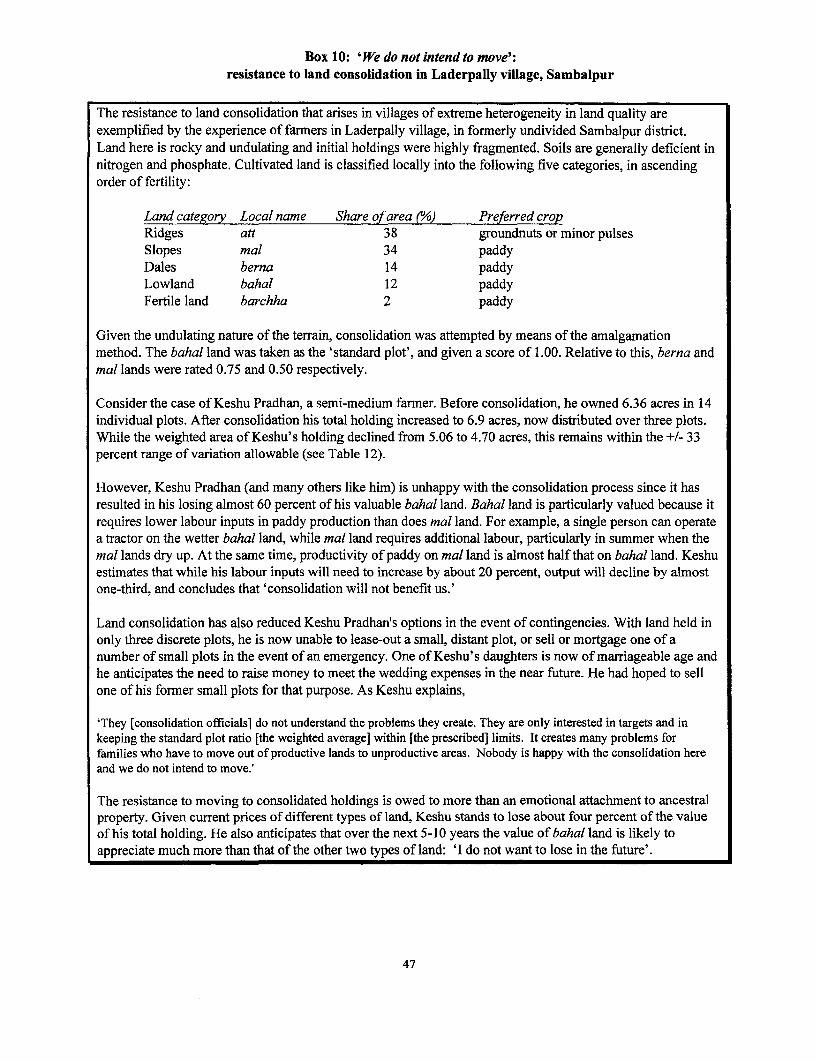
Box 10: 'We do not intend to move':resistance to land consolidation in Laderpally village, Sambalpur
The resistance to land consolidation that arises in villages of extreme heterogeneity in land quality areexemplified by the experience of farmers in Laderpally village, in formerly undivided Sambalpur district.Land here is rocky and undulating and initial holdings were highly fragmented. Soils are generally deficient innitrogen and phosphate. Cultivated land is classified locally into the following five categories, in ascendingorder of fertility:
Land category Local name Share of area (°/) Preferred cropRidges att 38 groundnuts or minor pulsesSlopes mal 34 paddyDales berna 14 paddyLowland bahal 12 paddyFertile land barchha 2 paddy
Given the undulating nature of the terrain, consolidation was attempted by means of the arnalgamationmethod. The bahal land was taken as the 'standard plot', and given a score of 1.00. Relative to this, berna andmal lands were rated 0.75 and 0.50 respectively.
Consider the case of Keshu Pradhan, a semi-medium farmer. Before consolidation, he owned 6.36 acres in 14individual plots. After consolidation his total holding increased to 6.9 acres, now distributed over three plots.While the weighted area of Keshu's holding declined from 5.06 to 4.70 acres, this remains within the +/- 33percent range of variation allowable (see Table 12).
However, Keshu Pradhan (and many others like him) is unhappy with the consolidation process since it hasresulted in his losing almost 60 percent of his valuable bahal land. Bahal land is particularly valued because itrequires lower labour inputs in paddy production than does mal land. For example, a single person can operatea tractor on the wetter bahal land, while mal land requires additional labour, particularly in summer when themal lands dry up. At the same time, productivity of paddy on mal land is almost half that on bahal land. Keshuestimates that while his labour inputs will need to increase by about 20 percent, output will decline by almostone-third, and concludes that 'consolidation will not benefit us.'
Land consolidation has also reduced Keshu Pradhan's options in the event of contingencies. With land held inonly three discrete plots, he is now unable to lease-out a small, distant plot, or sell or mortgage one of anumber of small plots in the event of an emergency. One of Keshu's daughters is now of marriageable age andhe anticipates the need to raise money to meet the wedding expenses in the near future. He had hoped to sellone of his former small plots for that purpose. As Keshu explains,
'They [consolidation officials] do not understand the problems they create. They are only interested in targets and inkeeping the standard plot ratio [the weighted average] within [the prescribed] limits. It creates many problems forfamilies who have to move out of productive lands to unproductive areas. Nobody is happy with the consolidation hereand we do not intend to move.!
The resistance to moving to consolidated holdings is owed to more than an emotional attachment to ancestralproperty. Given current prices of different types of land, Keshu stands to lose about four percent of the valueof his total holding. He also anticipates that over the next 5-10 years the value of bahal land is likely toappreciate much more than that of the other two types of land: 'I do not want to lose in the future'.
47

Table 12: Impact of land consolidation on one holding, Sambalpur district
Land Relative Approx Before Consolidation After ConsolidationCategory Weighting price
(Rs. Peracre)
Area No. of Imputed Area No. of Imputed(acres) plots value of (acres) plots value of
holding (Rs.) holding (Rs.)Bahal 1.00 80,000 3.00 3 240,000 1.25 1 100,000Berna 0.75 60,000 1.50 3 90,000 2.50 1 150,000Mal 0.50 50,000 1.86 8 93,000 3.15 1 157,500
Total 6.36 14 423,000 6.90 3 407,500Weighted 5.055 4.70
total
Source: Field notes, Laderpally village.
* information asymmetries and transaction costs: A possible reason for the infrequency of voluntaryexchange of land parcels between farmers may be the lack of necessary information about the potentialproductivity of each other's land. However, this seems unlikely in villages where there can be few secrets.It seems more plausible that farmers may be unable to agree on the exchange value of fragments in thecontext of thin land markets. Uncertainty surrounding its legal status and the high cost of obtaining pattasmay also discourage potential transactors.
* need to hold land as a liquid asset: Land enters the sale market infrequently and in small fragments.Landowners will be unwilling to consolidate their land parcels as this might preclude the option ofselling/mortgaging a small piece of land in order to meet future contingencies (e.g. marriage or funeralcosts). The discussion in Section 4.1.4 established that most land sales are distress sales. Clearly,consolidation programs that seek to restrict resale also restrict the liquidity of land as an asset in the limitedportfolio available to cultivators (Heston and Kumar, 1983).
Of these, soil heterogeneity seems to be the chief constraint on land consolidation in the north-western plateauof Orissa, and risk aversion in unirrigated regions. While high transaction costs in land markets also act as adisincentive to voluntary consolidation (i.e. the voluntary exchange of plots), the importance of holding land asa liquid asset, in the absence of other durable assets or steady income-streams, is a critical factor in explainingthe widespread resistance to land consolidation in practice.
4.2.6 Policy issues
Land consolidation, where it may successfully be implemented, is more likely to contribute positively toagricultural productivity than to improving access to land for the poor. In theory, consolidation ought notchange net land distribution, and so should not leave the poor worse off. Our findings in Orissa suggest thatland consolidation, like land survey and settlement operations, actually tends to worsen land distribution at thebottom end, to the extent that it has brought about any real change on the ground. While land consolidationmay contribute positively to agricultural productivity under certain conditions, it will not help increase accessto land for the rural poor unless attention is also paid to other aspects of a land reform agenda. For instance,insecure tenants and share-croppers whose names do not appear in land records may lose their rights in land, ifconsolidation is pushed through without first securing their rights.
48
Moreover, under existing practices of partible inheritance, land consolidation can only ever be a temporary,or stop-gap solution to the problems attributed to land fragmentation, since the gains achieve will be erodedover time with the subdivision of holdings upon inheritance.
4.3 Land encroachment
One way in which the rural poor and other socially excluded groups compensate for their lack of access to andcontrol over privately owned arable land is through access to common and public land (Meams, 1998). Ofcourse, non-poor and larger landowners also seek to increase their effective landholding by occupyingcommon land. Commons in Orissa amount to around 20 percent of the total area of the state, including (seeTable 1):
* 'barren and uncultivable wastelands' (3 percent of total area) which are set aside for public or communalpurposes and are not generally liable for revenue;
* 'cultivable wastelands' (peromboke, 3 percent area) which have been cultivated in the past but have beenleft uncultivated and subsequently purchased or otherwise acquired by the government;
* 'permanent pasture and other grazing lands' (gochar, 4 percent area); and* village forests (9 percent area).
The first three categories are revenue lands and the last is owned by the Forest Department. All four categoriesfall within village boundaries and are also known as village lands. The land revenue department classifiesvillage lands into 'non-objectionable' and 'objectionable' lands. Only government-owned cultivablewastelands constitute 'non-objectionable' land, which may be granted to landless households as describedbelow. The 'objectionable lands' include gochars, cemeteries, village roads, all forest lands, tanks, tank beds,and river embankments. None of these lands should be encroached upon for settlement or cultivation. Thereality, however, is very different.
Land encroachment is the result of:
- loopholes in land reform legislation: The Orissa Estate Abolition Act, 1952 was biased in favour ofestate owners as it allowed them to keep 33 acres for personal cultivation. All tenants on the 'resumable'area of each estate were evicted for fear that they would otherwise acquire ownership rights to the land.The Orissa Tenant Protection Act, 1948 and the Tenant Relief Act, 1955, while seeking to protect tenantsfrom unlawful eviction, could not be enforced adequately owing to the absence or manipulation of landrecords. Evicted tenants were thus compelled to eke out an existence by encroaching on government orcommon lands;
* displacement as a result of development activities: Inadequate attention tends to be paid to resettlementand rehabilitation of people displaced by large development projects (dams, irrigation schemes, miningoperations, etc.) (see Box 11). To the extent that displaced communities are resettled at all, they arefrequently allocated remote land of poor quality. Consequently, displaced people tend to encroach,illegally, on nearby government land;
* lax implementation of existing land laws by revenue officials: For instance, those who encroach ongovernment land are required to be 'booked' by the revenue inspector (RI) and have proceedings initiatedto evict them. However, encroachment represents an opportunity for rent-seeking by revenue officials.Instances of encroachment on public and common land are overlooked, in return for a suitableconsideration, usually payable annually. This practice clearly encourages encroachment in the long-run,and favours larger landowners who are most able to pay the requisite bribes;
49

* increasingpressure on land: Orissa's population, growing at an annual rate of 2 percent, continues todepend substantially on agriculture for their livelihoods. The 'cultivable land' frontier is therefore beingpushed progressively further onto government and common land.
4.3.1 Typology and extent of encroachment
In Orissa, all types of common land are under threat of encroachment. In private discussions, governmentofficials freely acknowledge the widespread encroachment of government land, but official data is either notgathered or not readily forthcoming. For example, survey and settlement operations do not recognise claimsestablished through encroachment. The reason for this is to preserve original rights in land, but the opportunityis missed to acquire more reliable aggregate data on the extent and forms of encroachment. An encroachmentregister is maintained at tehsil level, for purposes of proceeding with eviction cases from government land.Owing to the incentives for rent-seeking at this level, these data must be regarded as highly suspect. They arenot, in any case, aggregated at any higher level, although in principle some monitoring of encroachment iscarried out at district level.
Who encroaches on what types of land? Table 13 summarises the current status of encroachment on differenttypes of public and common land. An important type of interaction between the state and the land user is thede facto 'privatisation' of common lands through encroachment. Successful encroachment of peromboke landsand other common lands (such as uncultivated wastelands) depends upon the degree of influence theindividual encroacher enjoys, both with regard to other villagers and to government revenue departmentofficials. Individuals of widely differing socio-economic status encroach upon peromboke land. Landless andnear-landless households are perhaps the most numerous, but their position is vulnerable to better-off andrelatively more powerful groups who are able to employ intimidatory tactics to evict them. Those with agreater degree of influence may be in a position to see that weaker groups are evicted, yet also manage toevade the law themselves through bribery to allow their encroachment on public and common land to gounnoticed, and eventually to have the encroached land registered in their own names. A lengthy process of defacto occupation ofperomboke land and payment of annual fines for encroachment may thus eventually leadto a change in the revenue classification of the land and acquisition of legal title. Revenue records inevitablylag significantly behind the true extent of encroachment at any given moment.
From our field investigations, it appears that opportunities for further encroachment are now generally limited.Local revenue records and discussions with Rls and tehsildars reveal that most of the encroachment takesplace on land designated as peromboke, cultivable waste, permanent pastures and other grazing lands, and onlyto a very limited extent on land under the jurisdiction of the forest department. Focus group discussions with
50

Box 11: How development can reduce access to land
Until 1981, coal mining companies could acquire substantial tracts of land with few restrictions under the CoalBearing Areas Act. Under an agreement reached in 1981 between GOO and the coal companies, land is nowrequired to be acquired by the Revenue Department at market rates (under the Land Acquisition Act) and eachdisplaced family is to be assured of one permanent job in the mines.
Two major obstacles have frustrated the original intentions of this agreement:
* the definition of family': households often consist of extended families with several adult members. Onlyone will be found a job although all are displaced.
* inadequate land records: since land claims may not be accurately established in land records, intra-familystruggles may ensue to establish a claim to the single job offered in compensation. All other householdmembers are forced to seek alternative livelihoods.
The loss of common land is generally not compensated under this agreement, which adversely affects thelandless. One study of people displaced by the Upper Indravati dam in Koraput district found that many of thedisplaced were landless people dependent upon podu (shifting cultivation) on common lands (Mohapatra,1983). Entitlement to government compensation rested upon private property rights only and ignoredcustomary rights in common property.
villagers revealed that little usable common grazing land remains. Grazing commons have either beenencroached upon or are so degraded that they are no longer used for grazing and the animals are now stall-fed.
In the absence of more reliable data, it is difficult to form an accurate view of the socio-economic status ofthose who encroach on common land. A series of focus group discussions with land owners and landlessfarmers in Laderpally village, Sambalpur district, suggest that 90 percent of all who encroach on village landin Laderpally own less than two hectares of private land. Medium and large farmers make up the remaining 10percent. The estimated distribution of encroachers by size of class of existing land holding is as follows:
Landless 10%Marginal (0-1 ha) 10%Small (1-2 ha) 70%Semi-medium (2-4 ha) 5%Medium and Large (>4 ha) 5%
At least in Laderpally, much of the impetus for encroachment comes from small farmers, belonging to themiddle level of the village hierarchy. While poor, they are not the poorest, and while predominantly dependentupon agriculture, it is not their only source of livelihood. There is evidence that, having acquired some skillsand education, small-farmer households are beginning to move into the service sector and rural non-farmenterprises (Sarap, personal comm.). This upwards mobility provides them with the additional clout in thevillage necessary to displace poorer groups from common land, and the ability to influence lower-level landrevenue officers to their advantage.
51

Table 13: Encroachment by land category
Ownership Land category Use Status Means of Whether land transfer Ground-level realitystatus (share of total increasing legally permissible
state land area) private landaccess
Barren/ Village Commons Encroachment Landless categories can be settled Extensively encroached both byUncultivable after being booked by RI; other landowners and landless;wasteland (3%) categories evicted encroachers rarely booked by RI;
widespread rent-seekingGovernment Cultivable Village Commons Encroachment Landless categories can be settled Extensively encroached both byland wasteland (3%) after being booked by RI; other landowners and landless;
(Peromboke) categories evicted encroachers rarely booked by RI;widespread rent-seeking
Permanent pastures Village Commons Encroachment Private ownership not permitted Extensively encroached both byand other grazing landowners and landless;lands (Gochar) encroachers rarely evicted;(4%) widespread rent-seekingLand owned by Private land most Sale, exchange, Permitted though restrictions on Increasing conversion ofnon-tribals commonly used for inheritance converting crop land for non- agricultural land for non-(area n/a) cultivation, recent attempts agricultural purposes agricultural uses
to convert for non-agricultural purposes
Private land Land owned by Private land for settled or Sale, exchange, Permitued only among the Legislation ineffective intribals shifting cultivation, though inheritance scheduled tribes and scheduled controlling tribal land alienation;(area n/a) decline in latter castes. Transfer to non-tribals permission from revenue officials
only under exceptional available at a 'price'circumstances and not withoutpermission of revenue authorities
52

4.3.2 Land alienationfrom tribal groups
Orissa has a large tribal population (22 percent of total population, three times the average for India)and tribal land alienation by moneylenders has long been recognised to be a critical issue. Tribalpeople, with generally low educational and skill levels and limited access to formal credit markets,have had little option but to seek credit at high rates of interest from moneylenders. In the event ofdefault on loan repayments, moneylenders have tended to appropriate first tribals' forest produce, andlater their land itself. This process has been reported in numerous village studies dating at least as farback as Bailey's classic study of socio-economic change in a western Orissa village since the late 19thcentury (Bailey, 1957).
Alienation of land held by members of Scheduled Tribes (ST) has been restricted by legislation as amatter of public policy. After Independence, the Constitution of India enabled state governments tomake regulations restricting alienation of land by STs in Scheduled Areas. In Orissa, Regulation 2(1956) in Scheduled Areas provides that land held by a person belonging to a scheduled tribe cannot,without permission of the appropriate authorities, be alienated to a person not belonging to ascheduled tribe. The law also allows for a suo moto action by the Collector for restitution of alienatedtribal lands. Section 22/23 of the OLRA applies to prevent land alienation by tribals in non-scheduledareas.
In practice, however, land alienation remains prevalent if officially unacknowledged (Fernandes et al.,1988). When money is lent, the loan agreement ensures that the moneylender has rights over all theproduce for a certain number of years (usually nine). Since the borrower is therefore left without anyincome, he is forced to keep borrowing, thereby mortgaging the produce of his land for manysubsequent years. Rights to the produce of the land eventually accrue to the moneylender for such along period that tribal land owner is reduced to the status of little more than a bonded labourerproducing crops for the moneylender, on land that legally remains his own. One study of four districts(Dhenkanal, Ganjam, Koraput and Phulbani) estimated that about 56 percent of the total tribal landwas lost to non-tribals over a 25-30 year period through these means (Viegas, 1987). Of this total, 40percent was lost through indebtedness and land mortgage, 23 percent through encroachment, 17percent as a result of displacement by development projects, 15 percent through personal sale, and thebalance due to floods and other natural calamities.
A less well-understood pattern is the administrative erosion of tribals' communal land rights throughsurvey and settlement operations themselves. In recent decades, cadastral survey by the chain surveymethod has gradually given way to the plane-table method to reduce operational costs. But land with agradient greater than 10 percent cannot accurately be surveyed by the plane table method, and inOrissa these unsurveyed lands have customarily been lumped together as 'uncultivable wasteland' inthe record-of-rights in land (Roy Burman, 1987). The outcome is catastrophic for tribal groups. In a1961 land survey and settlement operation in Niyamgiri hills of south-western Orissa, for example,only 15 acres out of a total village area surveyed of 2647 acres were declared to be 'cultivable land'(Roy Burman, 1987). Only on this land was rent assessed and demanded of the 16 owners in thevillage. One acre was recorded as grazing land, 7 acres under housing, and only half an acre classifiedas common land for the village graveyard. The remaining 2624 acres, being of a gradient greater than10 percent, were recorded as (state-owned) 'uncultivable wasteland'. In reality, much of this area wasowned by tribal households, and was cultivated in demarcated plots on which fruit trees had beenplanted.
Anecdotes abound concerning the loss of tribal land to powerful interest groups and the lower levelsof the land revenue administration. Even discounting a certain amount of exaggeration, it is difficult to
53

ignore the emerging picture of a steady process of land alienation, in spite of the well-intendedlegislation designed to prevent it. Clearly, legislation alone is inadequate to bring about social justice.It needs to be accompanied by socio-political consciousness-raising and awareness-building amongtribal groups of the sort that is being undertaken throughout Orissa by civil society organisations. Forexample, Gram Vikas, an NGO based in Berhampur, Ganjam district, has won several landslide legalcases by hiring lawyers to act on behalf of tribal communities in public-interest litigation to defendtheir land rights.
4.3.3 Legalframework and how it operates
The central purpose of the Orissa Prevention of Land Encroachment (OPLE) Act, 1972 is to preventunauthorised occupation of government land. It is even-handed and clearly lays down penalties for allinstances of encroachment, to be followed by eviction. Through a 1982 amendment the state hasrecognised that there are different types of encroachers on different types of lands (see Table 13).While all encroachers are required to be evicted from 'objectionable' lands, landless encroachers arelegally entitled to be settled on up to I standard acre per family of 'non-objectionable' land (i.e.cultivable wasteland).
The eviction process proceeds as follows: (i) based on his enquiries, the RI files a report to the landrevenue (tehsildar's) court, and legal proceedings are initiatied; (ii) the tehsildar issues notice to showcause why penalty should not be imposed; (iii) encroacher shows such cause; (iv) if this cause isadmitted as valid, the mutation process is initiated for the issue of patta to the land; (v) if cause notadmitted as valid, notice is issued for imposition of penalty and eviction within 30 days. The statutoryminimum period for the entire process is three months, but in practice cases may take between sixmonths and a year to settle/ dispose of.
Steps (i) to (iii) in the above sequence are similar for both landless and landowning encroachers on'unobjectionable' land. Only landless encroachers may move to step (iv), whereas landowning orother ineligible encroachers are issued penalty and eviction notices as in step (v). As described earlier,however, the incentives for RIs and other tehsil-level officials to 'book' encroachment cases in thismanner are very low, as encroachment represents a lucrative source for rent-seeking.
The consequences of this process for various stakeholder groups are as follows:
Landless: Although legally entitled to claim rights to 'non-objectionable' land, landless encroachersmust first commit what is regarded as an unlawful act (encroachment) and be 'booked' for it beforethey are allowed to press their claim by establishing 'due cause' by virtue of their landlessness. Onlythen, and after due process of law, may they be issued with the patta which regularises their landrights. The entire process hinges upon whether or not the case is 'booked' by the RI in the first place.There are few or no incentives for the RI to do so and frequently bribes are demanded or evictionthreatened. The landless encroacher, if unaware of the their rights under OPLE, is likely willing tosuccumb to the RI's demands in return for temporary access to cultivable land. Even if aware of theirrights, landless encroachers may still prefer to take the easier option of regularly bribing the RI sincethey are also likely to be aware of the numerous transaction costs incurred at the tehsil office ininitiating a mutation and obtaining patta to the land (see Box 12).
Landowners: There are few disincentives under the law for an already landed encroacher to vacateillegally occupied government land. The penalties for encroachment on government land, fixed in1976, are set at the very low level of Rs. 100 per acre per year. The assessment is based upon land
54

classification fixed by settlement authorities; and if the land is irrigated, then water rates of Rs. 36per acre (during rabi season) and Rs. 16 per acre (during kharif) are also levied. If the land is put tocommercial use (e.g. operating a rice mill), the penalty is Rs. 10 per day.
Revenue officials: The low penalty and assessment rates provide a perverse set of incentives for theRI and the tehsildar that actually serve to encourage encroachment on government land. Theimposition and collection of penalties from encroachers has emerged as an important component ofthe tehsil's income from 'penalty and rent cess', owing to the now very low levels of land revenue.Perversely, the tehsildar may be more willing to allow encroachment on objectionable land since thepenalty amounts to more than the land revenue demand from that land. In Attabira tehsil, Sambalpurdistrict, for example, the annual income from 'penalty and rent cess' is about Rs. 60,000. According tothe tehsildar, a large proportion of this income derives from the fines levied on encroachers. Thetehsildar elaborated that the amount had increased in recent years 'because of increased pressure onland.' Since land revenue derives from a more or less constant area, we assume that 'increasedpressure on land' is a euphemism for increased encroachment on government land, thereby increasingpotential government income from penalties.
It is often the case, especially in unirrigated areas, that encroachers are evicted but leave only afterharvesting the crop35 . They are likely to return during the following cropping season, however, oftento the same plot of land, and the penalty process starts all over again. The penalty remains constantirrespective of the number of times a particular farmer encroaches on government land.
Box 12: Operation of the OPLE in Ganjam district
In Buruda village (Digapandhi tehsil, Ganjam district), 10-12 families encroach currently ongovernment land. The RI comes every year and instead of 'booking' them takes bribes from them, ofbetween Rs. 100 and Rs.400, depending on the extent of encroachment. The current 'going rate' isabout Rs.400 per acre. Often the landless encroachers have gone to the tehsildar and requested thattheir claims to the land be regularised and pattas be issued in their names. The tehsildar sends the RIto settle the matter who instead takes bribes. The encroachers are convinced that the RI must bepassing on a share of the bribe to the tehsildar, and perhaps even to higher-level officers. Oneinformant encroached on 80 decimels of land and paid a bribe of Rs.370 in 1997. The RI measures theland, says he will issue apatta, but never does so. He threatens them, saying that if they fail to pay, hewill not allow them to harvest their crop. This has been going on for the last 15 years.
4.3.4 Conclusion
The discussion in this section reveals that existing legislation to prevent encroachment and alienationof tribal land have failed in their objectives. Loopholes in the law encourages rent-seeking, andcomplex rules are easily manipulated by vested interests. The rural poor may acquire defacto butinsecure rights over revenue wastelands through encroachment, but are unable to convert them to thedejure rights to which they are entitled under the law, and are therefore also denied access tocomplementary resources such as institutional credit.
3 5 It is rare that the tehsildar would impound the standing crop and auction it, as he is supposed to do.
55

At present, there are few effective sanctions to prevent the encroachment on commons by non-poorgroups. Existing penalties under the OPLE are too low and are rarely enforced. Computerisation of theencroachment register at tehsil level will make possible the ready detection of habitual encroachers.Increasing the penalty according to the frequency of repeat encroachments may also act as somedisincentive, although only over the medium-term rather than the short-term, and not so long asincentives towards rent-seeking remain strong for low-level revenue department officials.
The inefficiencies and distorted incentive structure that prevail in land revenue administration are onlylikely to be checked with greater awareness and voice on the part of local communities. In order forlocal groups to be able to press their legal claims, they first need to know what their rights are. Acombination of awareness-raising and local organisational capacity-building, efforts to expand theeffective powers and accountability of the panchayati raj institutions, increased vigilance of superiorofficers in the revenue administration, and an informed public opinion (e.g. through readily accessiblemanuals in local languages) are required in order to protect and promote access to remaining commonland by the rural poor.
4.4 Land tenancy
The abolition of tenancy in order to vest land ownership with the actual tillers of the land formed thecorner-stone of most land reform efforts in India after Independence in 1947. It was predicated on thewidely (and then largely correctly) held belief that the tillers of the land were locked in exploitativerelationships with intermediaries who had little interest in the land but for the extraction of rent. TheOrissa Estates Abolition (OEA) Act, 1952 initially permitted landowners to resume 33 standard acresfor personal cultivation (section 2.3), which led to the large-scale eviction of tenants. No parallellegislation was introduced to protect tenants. Under the Orissa Land Reforms (OLR) Act, 1960 (asamended in 1972), the leasing of land was explicitly banned, except where lessees fell into certainexcluded categories36. Under the 'adverse possession' clause in the OLR Act, if it can bedemonstrated that a tenant has cultivated a parcel of land continuously for 12 years, permanentoccupancy rights to that land may legally pass to the tenant. But the institution of tenancy has provedto be highly resilient on the ground, for reasons outlined below, and attempts to regulate tenancy bylegislative means have been counterproductive. It is as widespread in Orissa as it is illegal, thoughnow less exploitative and better concealed from official records.
A substantial literature now corrects many long-standing perceptions that share tenancy is necessarilyinefficient or that landlord-tenant relations are necessarily exploitative (Otsuka and Hayami 1988,Singh 1990). Share tenancy represents a second-best response to missing, thin and imperfect marketsfor land, credit, labour, management, information, and insurance, and performs some very importantfunctions which would otherwise have to fulfilled by other institutions; it is neither necessarilyinefficient nor a barrier to the adoption of new technology; tenancy contracts often play an importantrole in matching land, labour and capital endowments. They are not necessarily exploitative, but
36 Except by landlords with a disability or the 'privileged raiyats'. A person under disability refers to: (i) awidow or unmarried woman, or a woman divorced or separated from her husband by a decree or order ofcourt; (ii) a minor or a person of unsound mind; and (iii) a person incapable, because of some otherphysical or mental disability, of cultivating personally the land he held as a raiyat. Privileged raiyatsinclude (i) trusts holding land for public purposes; (ii) charitable and educational institutions engaged inwork for public benefit; and (iii) religious or other institutions by which the public benefit.
56

where they are, owing to the unequal bargaining power between agents, attempts to 'fix' relations inone sphere can lead to compensatory shifts in other contracts to leave tenants net worse off (Mearns1998).
This section examines the extent and nature of land-lease (tenancy) markets and the terms of thecontracts across Orissa to understand how formal restrictions on tenancy along with loopholes in thelaw, its lax implementation, lack of updated land records, and the manipulation of revenueadministration by the relatively rich and powerful, combine to restrict access to land by the rural poor.
4.4.1 Extent and nature of tenancy in Orissa
There is general agreement that available data on both the number of tenants and the acreage undertenancy are underestimates (Singh, 1988). Both the Census of Land Holdings carried out by theNational Sample Survey Organisation, and the Agricultural Census, tend to underestimate theproportion of land under tenancy. However, the former is considered more reliable as it is based onindependent household surveys while the agricultural census is based on a retabulation of the landrecords of owner-cultivators. The under-estimation of tenancy stems from reporting bias as lessorstend to understate the leased-out area owing to (i) the fear that tenants will stake claims in favour ofcontinued right of cultivation; (ii) desire to escape the ceiling on land holdings; or (iii) a combinationof (i) and (ii). The share of operated area leased-in is therefore considered to be a more reliablemeasure of the magnitude of agricultural tenancy than the share of owned area leased-out as lesseeshave fewer incentives to under-report the extent of area leased-in (Narain and Joshi, 1969).Nonethless, land reform legislation designed to prohibit sub-letting, regulate rents, and confer securityof tenure has given many landlords and tenants a common interest in concealing agreements whichmay be deemed illegal (Singh, 1988). Only intensive field surveys and careful village studies canprovide more precise estimates of tenancy since '[Tihe longer the period of stay in villages, the higheris the tenancy recorded' (Laxminarayan and Tyagi, 1977: 880).
Unfortunately, there is a dearth of surveys and few village studies in Orissa which offer such insights.This section combines field notes gathered in the course of the present study with material from twoin-depth field studies (Sarap, 1998; Swain, 1998) to form a partial picture of the extent and nature oftenancy arrangements in different parts of Orissa.
It is estimated that on average, 10-20 percent of households in each village participate in the land-lease market in Orissa, although this is subject to wide inter- and intra-regional variation. Using NSSdata, Swain (1998) reported that 17 percent of households leased-in land in 1981-82. More than 80percent of the leased-in area is in the size class of less than 10 acres, and the percentage of leased-inarea to operated area decreases with the increase in size of operational holding. At the same time,nearly 85 percent of the area leased-out is by farmers with less than 10 acres. Together these resultsindicate considerable leasing activity (both in and out) by small and marginal farmners.
Land leasing or tenancy may take the form of fixed rentals or sharecropping arrangements, in whichrents are paid in cash, in kind, or a combination of the two. Sharecropping is the predominant, thoughdeclining, form of tenurial arrangement in Orissa. About 42 percent of the leased-in area is undersharecropping as against about 14 and 8 percent respectively under fixed-produce and fixed-rentcontracts (Swain, 1998). However, share tenancy seems to be more prevalent in non-irrigated villagesthan in irrigated villages. For example, Swain (1998) reports that more than 40 percent of theoperational area is under share tenancy in a dry village in Dhenkanal district as against 12-19 percentin irrigated villages in Cuttack district. This pattern seems to confirm the persistence of the potentialfor risk-sharing under share-cropping contracts.
57

On the other hand, fixed tenancy with payment in varieties of cash and kind is common in theirrigated villages in Sambalpur district (Sarap, 1998). Only about 20 percent of land-leasinghouseholds were found to participate in sharecropping (bhagidi) contracts. They were smalllandowners and the primary reason for leasing-out land was their inability to cultivate land either withthe help of family labour or by hired labour37 . Land leasing on fixed tenancy is of two types: in kind(kara), when the agreed amount of paddy is delivered after the harvest; and in cash (chhidol) wherethe rent is paid up front in cash before the lessee is permitted to use the land. The kara lessors tendedto be small farmers with limited access to family and/or hired labour (army personnel, widows); ormedium farmers with an adverse land-labour ratio. Among the chhidol lessors, nearly half resided inother villages, and leased out their land because these plots were at a distant location and of inferiorquality. The other chhidol lessors were small farmers who required funds for urgent purposes. Therents paid by lessees varied from Rs. 120 to Rs. 550 per acre per year; this wide range in rents payableis indicative of the heterogeneous terms and conditions among such contracts.
Table 14 provides a typology of various land leasing contracts in different parts of Orissa, and Table15 summarises the most common reasons for leasing land. It is evident that leasing householdsparticipate in the tenancy market in response to missing markets for labour or draught power.
4.4.2 Terms of tenancy contracts
Tenants are under no obligation to lease-in land from a particular lessor. They are quite free to taketheir own decisions on how much land area to lease-in and from whom, and are not expected toprovide unpaid labour to the lessor. However, it was commonly reported that tenants may borrowmoney from their landlords and repay the loan with labour contributions. While there is little evidenceof extra-economic coercion in leasing contracts, it does appear that some factor markets may beinterlinked. Unlike the situation that prevailed prior to Independence, tenants no longer appear to belocked into exploitative relationships with landlords. At the same time, they have no legal statusbecause tenancy is banned.
In leasing out land, landowners employ various devices to get around the law banning tenancy. Mostcontracts are oral and of short duration. Oral contracts help to ensure that tenants are not recognised inthe updated land records during survey and settlement operations (section 3.1). At the same time,short-term contracts (typically 2-5 years), prevent tenants from establishing claims to land through'adverse possession'. Under the adverse possession rule, a tenant who has been in practical possessionof a plot of land for a period of 12 consecutive years may thereby acquire legal occupancy rights tothat land.
Rule 21 of the Orissa Survey and Settlement Rules, 1962, clearly specifies the particulars that need tobe recorded in the preparation of the RORs. These include the name of each tenant or occupant; theclass to which each tenant belongs; the situation and extent of the land held by each tenant oroccupant; the name of the landlord of each tenant; and the name of each proprietor and landlord.
37 There is a close relationship between the two, since hired labour normally requires supervision by familymembers.
58

Table 14: Typology of land tenancy contracts in different parts of Orissa
Form Terms of contract Common among: Geographical Whetherlocation limited to
particularcrops
Lessors LesseesGross output dividedequally (1:1) between Landless, andlandlord and tenant Small and small andafter deduction of marginal marginal Sambalpur Noexpenditure on farmers farmerschemical fertilisers orHYV seeds
Sharecropping Landless, andGross output divided Small and small and Cuttack, Khurda, Paddy, gram,equally (1:1) between marginal marginal Gopalpur lentils and jutelandlord and tenant farmers farmers
Gross output divided Small and Small andeither (1:2) or (1:3) marginal marginal Cuttack Potatobetween landlord and farmers farmerstenant respectively
Agreed amount (8-10Fixed tenancy bags/acre/crop) to be Medium Small andin kind paid after harvest; farmers marginal Sambalpur Paddy
tenant responsible for farmerscultivation
Agreed amount of Medium Small andFixed tenancy cash paid to landlord farmers marginal Sambalpur Paddyin cash before getting access farmers
to land
Source: Sarap (1998), Swain (1998), and field notes.
Table 15: Common reasons for leasing land in Orissa
Leasing-out Leasing-in* Lack of supervisory labour * Limited non-farm employment opportunities (i.e.* Lack of bullock power excess labour-land ratio)* Small (uneconomic) holding * Availability of bullocks* Land distant or of poor quality * Consolidate and increase operational holding
Source: Sarap (1998), Swain (1998), and field notes.
59

In practice, however, landowners are easily able to ensure that the record-of-rights in land do notmake mention of any existing tenants. During our field investigation, many instances were reported inwhich land rights were mis-recorded during survey and settlement operations. Tenants also have goodreason to conceal tenancy, as highlighted in Box 12. In 1981-82, an estimated 36 percent of alltenancies in rural Orissa were concealed (Sawant, 1991).
Box 13: Tenant motivations for concealing tenancy
Consider this apocryphal tale of a conversation between a politician and a tenant in rural Orissa. Thepolitician said to the tenant, "You have lived on this land for so many years, the land is yours.Register a case against the landlord." The tenant replied, " How can I start a case against him? I knowthis land is his. How can it suddenly become mine? When I have problems I go to him for help. Welive in the same village and we see each other every day. You are here now, but after one hour youwill be gone and it will be difficult for me to see you. How can we get their land in our name? It isnot good."
Source: Mohanti (1990)
4.4.3 Policy Implications
The discussion in the preceding sections highlights that:
- tenancy (whether sharecropping or fixed-rent) is as widespread as it is illegal;* the rent paid by the lessee is almost always in excess of the legally stipulated rent of one-fourth of
the gross produce;* most of those seeking to lease-in land are either the landless or the small and marginal farmers
suggesting that lease markets are of great importance as a means for the rural poor to gain accessto land; and
• both landowners and tenants have their own reasons to conceal tenancy arrangements.
Tlhis suggests that:
* tenancy is a response to missing markets, especially for labour;* rent is determined more by prevalent social and cultural norms of fairness than by state legislation;* most transactions are non-exploitative as they take place often within the same class of farmers,
and are an effective mechanism for the poor and the landless to increase access to land, and* concealing of tenancy affects the tenants adversely by denying them security of tenure and
consequently limiting their access to institutional credit.
The key policy issue is to devise an effective mechanism to deregulate tenancy but at the same timelegally to register and make possible the protection of tenants' rights in land. The question ofderegulating tenancy has been discussed in a meeting of the Orissa Cabinet in which opinion wasdivided on whether or not to grant tenants new rights. Many Members feared a political backlashagainst any move to grant heritable and transferable rights to the tenants. In principle, at least, it ispossible to specify a 'middle ground' in the hierarchy of rights in which tenants' use rights are
60
protected without threatening the landlord's ultimate rights of ownership. It is argued that writtencontracts with protection under the law would, on the one hand,
* provide security of tenure to the tenant in the short-term;* enable him to access institutional credit; and thereby* improve agricultural productivity,
and on the other,
* release more land into the land-lease market as landowners would be less fearful of losing theirland through 'adverse possession', and
* help to increase access to land by the rural poor.
61
5. CONCLUSION
5.1 Policy implications
A number of implications for policy are suggested by this analysis. Many, but not all, of these optionsare already being considered, or imp'e'~mented in pilot forms by the Government of Orissa. A numberof these initiatives are also expected to be of relevance to other states:
* Gender and land rights: women's access to and effective control over land may be enhancedthrough joint land titling. This measure is rather limited in scope, since ideally what need to bepromoted are women's independent land rights. But while the principle of joint titling is readilyaccepted at the level of the Government of India, it has yet to be realized in practice in Orissa. Infocus group discussions, village women assert that their bargaining power vis a vis their husbandsand in-laws would be enhanced considerably by joint title over land. The common objection thatthis may make it more difficult for women to escape from abusive marriages was for them asecond order consideration.
* Organization of land administration: a critical assessment of the respective roles andresponsibilities of the Department of Revenue and the Board of Revenue appears warranted, inorder to identify overlapping functions and areas where coordination between the two could bestreamlined for increased efficiency. In the context of the ongoing computerization of land records,it will also be important critically to assess the particular responsibilities of the local-level RevenueInspector. Many of the presumed advantages of computerization will not be realized unlesslimiting constraints on RIs' time and the incentive structure within which they work are addressed.
* Land records and registration: at present, there is little or no coordination between themaintenance of land records, which is the responsibility of revenue inspectors and tehsildars; andland registration, which is the responsibility of sub-registrars. Measures to coordinate and integratethese two services and enhance their efficiency through computerization promise to go a long waytowards stimulating the land market. Of utmost importance is to combine registration and mutationprocesses, and provide a 'single-window' facility for the registration of sale deeds, correction ofthe record of rights in land, and issue of land title. Land records and the registration administrationsystem should integrated through a computer network to facilitate information exchange for thissingle-window approach. This should help to reduce the currently high, informal transaction coststo individuals in the land market. Existing registration fees and stamp duties should also bereassessed, as it is possible that their reduction, hand in hand with proper valuation, could lead to anet increase in state revenue.
* Survey and settlement operations: in the context of the computerization of land records, thecontinuing relevance of survey and settlement operations is questionable. There is substantialevidence that survey and settlement operations discriminate systematically against the rural poorand socially excluded, whose interests would be far better served by an efficient service forregistration of land sales, mutation and issuance of title.
* Simplification and transparency in land administration: Many of the individual stages involvedin land administration currently operate to the disadvantage of the rural poor and socially excludedgroups. The complexity of the existing legal framework and a perverse incentive structure providesconsiderable scope for rent-seeking by the lower-level government officers with whom landholderscome into direct contact, while village elites are better able to manipulate the system to their own
62
advantage. The draft Orissa Revenue Administration Bill is intended to simplify, consolidate andreplace the various laws that currently govern land administration. However, the extent to whichlegislative and organizational improvements in land administration will enhance access to land forthe rural poor, depends to a large extent on the degree of transparency with which landadministration is conducted in practice. Access to information and public awareness of rightsappear to be critical factors. The recent initiative of the Revenue Department, Government ofOrissa, to disseminate a local-language 'how to' manual on matters of land transfers and access toland records, is a most welcome contribution in this area, and one from which other states couldlearn.
* Land consolidation: the involvement of local NGOs in the formation of village committees forland consolidation may help to overcome some of the resistance to consolidation, whereconsolidation is genuinely demanded by particular villages, but where the government-initiatedprocess is perceived to be insufficiently participatory. NGOs could be encouraged to undertakemass-awareness generation by using informal media techniques (puppetry, folk theatre, etc.) andcreate a basis for negotiated and participatory land consolidation at village level. Thegovernment's role would be confined to the correction of existing land records, demarcation ofcommon lands, assistance in land measurement, and preparation of the new set of land records. Tothe extent that both poorer and better-off farmers wish voluntarily to consolidate their holdings inthe interests of raising productivity, the most effective public interventions are likely to be thosethat reduce transaction costs in the land market.
E Encroachment: the most promising avenues for protecting rights of access to common land for therural poor are through efforts to raise public awareness and access to information. Some NGOs inOrissa have been successful in pursuing public interest litigation to defend tribal land rights.Following their lead, the strengthening of local panchayats could make a vital contribution towardspromoting the watchdog function of civil society institutions. Only with strong civil societyinstitutions will there be effective demand from below for accountability within the lower levels ofland revenue administration, thereby limiting the possibilities for evasion of the legislationdesigned to prevent encroachment on commons. With such safeguards in place, thecomputerization of land records at tehsil level would also contribute towards making informationon the extent of encroachment more publicly accessible.
* Tenancy: liberalization of the land-lease market, as proposed in the draft Orissa RevenueAdministration Bill, and supported by Government of India policy under the Ninth Plan, istherefore cautiously to be welcomed, provided that the right balance can be struck betweenassuring landlords of their long-term ownership rights, and assuring tenants of their security oftenure and protection under the law for the duration of fixed-term tenancy contracts. Only withdocumentary evidence of such rights are tenants likely to face the possibility of access toinstitutional credit. The government's role would not be to specify the class of cultivators who maylease out their land, or to set a 'fair' rent as under the Orissa Land Reforms Act, but to ensure thatcontracts are upheld.
* Other market-based approaches to increasing access to land by the poor: learning fromexperience that land encroachment and tenancy, in spite of being banned, are widespread, thegovernment might consider additional, market-based mechanisms to increase access of land to therural poor. For example, a fixed proportion, say 50 percent, of the revenue wastelands should beauctioned for a limited, fixed period, for agricultural purposes. If at the same time, tenancy isderegulated, large landowners may be willing to take land on auction and lease-out to the smalland marginal farmers for cultivation. This would increase not only the poor's access to land but
63

also government revenue. The only proviso is that the penalty for encroachment should be sethigh enough to act as a disincentive.
5.2 Stakeholder analysis
The following is a brief summary of the major stakeholder groups that have interests in land and landadministration in Orissa. A number of other stakeholders have been left out of this analysis, includingcivil court lawyers, stamp vendors, and so on. A more complete stakeholder analysis would need toconsider all such groups.
Government of Orissa: The Department of Revenue and the Board of Revenue are the governmentagencies responsible for land revenue administration. Between them, at state level, they are primarilyresponsible for policy formulation and implementation, and adjudication of matters relating to landrevenue.
Tehsil-level revenue bureaucracy: The tehsil-level revenue bureaucracy is the cutting edge of landadministration. The key officials at this level comprise the tehsildar, the revenue inspector, the sub-registrar, the assistant settlement officers and the assistant consolidation officers. The last two operateat the level of a range which may or may not be coterminous with a tehsil. The tehsil-level officersfunction under the district collector for revenue administration and have primary responsibility forimplementing land policy.
Non-Governmental Organizations (NGOs): The strength and influence of the NGO community inOrissa has grown rapidly in recent years. Some are concerned with the protection of tribal rights toland and have been instrumental in initiating public interest litigation against the encroachment andalienation of tribal land by non-tribals and in promoting public awareness on these issues.
Large landowners: Large landowners, typically owning 5-10 acres of irrigated land, constitute thevillage elite, and usually wield considerable influence in village society. Much of their influence isderived from their control over land, labour and credit markets in the village. Although their powerhas been eroded to some extent by land reforms, they are still able to manipulate the landadministration system to their advantage by building coalitions with the tehsil-level bureaucracy. Theyusually lease out part of their land or hire wage labourers to cultivate their land as they diversify intonon-agricultural occupations.
Small and marginal landowners: These are usually owner-cultivators with about 1-5 acres of irrigatedland. Adjustments in operational holdings (e.g. in relation to the availability of labour or draughtpower) may be possible by leasing-in or leasing-out additional land. Agriculture is their main sourceof livelihood, though accompanied by seasonal non-farm labour.
Landless farmers: They do not own any land but rely on their own labour for a livelihood, by hiringthemselves out to other farmers as labourers. They are an important stakeholder group in land. Oftenthey attempt to increase access to cultivable land by encroaching on government wastelands or villagecommons.
Women: Women, even in better-off households, are considered a land-poor category owing to socialnorms and customs that, in spite of legal rights, deny them access to land.
64
Tribal communities: Orissa has a large tribal population which has traditionally relied upon forestland and resources for their livelihoods. Their access to and control over land often continues to bedetermined by custom. There are legal provisions to prevent tribal land alienation by non-tribals,which operate with varying degrees of effectiveness.
Using this simplified list of stakeholders, Table 16 summarises the possible consequences of thepolicy options suggested in section 5.1 for each stakeholder group.
As a second step in the stakeholder analysis, it is then useful to summarise potential conflicts andcomplementarities of interest between stakeholder groups in the form of a simple matrix, as shown inTable 17. The shaded cells highlight the probable sources of resistance to the main policy optionssuggested by this study. Most obviously, large landowners may be expected to use their politicalinfluence to thwart the Government's attempts to formulate policies that aim to increase the poor'saccess to land or to improve the 'efficiency' of land revenue administration, if this means they haveless chance of manipulating it in their own favour. Legislation to de-regulate tenancy might also beexpected to meet with stiff opposition owing to the complementarity of interests between the largelandowners and the legislators.
The state government might also need to be particularly mindful of the possible resistance to policyreform from the tehsil-level revenue officers. It may prove necessary for the state-level revenueadministration to build coalitions with selected junior officers to implement the new policiessuccessfully. This will also be necessary given the strong nexus of interests at village level betweenlarge landowners and tehsil-level revenue officers, which could so easily derail any casual attempts atreform.
5.3 Suggestions for follow up
A pilot study is constrained by its exploratory nature. It is suggested that further state-level studies beconducted, in selected states, applying the approach that has been tested here. The Annex specifies theminimum amounts of time required to conduct certain stages of the field investigation. The timerequired will naturally increase with an increase in the number of districts selected for analysis.
Priority states for subsequent studies would include Andhra Pradesh, Uttar Pradesh and West Bengal.Several criteria have guided their selection. Andhra Pradesh is a former ryotwari area with arelatively high agricultural growth rate, and demonstrated willingness to pursue improvements in landadministration (relative success with land consolidation, registration of informal tenancies, progresswith computerization of land records, and reform of the land administration agencies. Uttar Pradeshis a former zamindari area with high rates of tenancy and in which the need to deregulate land-leasemarket has been identified as an urgent priority. It also offers a relatively successful precedent withland consolidation, and a plethora of village studies and secondary data. West Bengal is also a formerzamindari area with high tenancy rates, and which has received wide acclaim for the systematicrecording of tenants' rights under 'Operation Barga'.
65

Table 16: Who will benefit and how: stakeholder analysis
Policy Option Government of Tehsil-level revenue NGOs Large land Small and Landless Women TribalsOrissa bureaucracy owners marginal farmers farmers
Issue jointpattas to Y N N y y
husband and wife (Promotion of social justice) . (Reduced perceived (Reduced perceived (Increased access to (Make landcontrol over family control over family land and control alienation
land) land) over land-related more difficult)________________ _____________________ ~~ ~~ ~~decisions) _ _ _ _ _ _ _ _
Evaluate the role of DRE Y N N _and BOR, and of the RI (Increased work efficiency) (Reduced potential for rent- (Reduced ability to (Reduced delays and
seeking) manipulate the rent-seeking)system)
Abolish survey and Y N N Y Ysettlement operations (Reduced costs) (Reduced potential for rent- (Reduced ability to (Reduced rent-seeking; (Make land
seeking) manipulate the less potential for losing alienationsystem) land to powerful more difficult)
interests)
Combine registration and Y N Y Y Ymutation (Increased revenue with less (Reduced potential for rent- (Reduced (Reduced transaction (Reduced transaction
incentive to undervalue seeking) transaction costs) costs) costs in the event ofproperty) land purchase)
Systematic Y N Y N Y Ycomputerization of land (Increased work efficiency) (Reduced potential for rent- (Improved (Reduced ability to (Improved access to (Make land
records seeking) access to land- manipulate the land-based information alienationbased system) more difficult)
information
Involve NGOs in land Y N Yconsolidation and (Improvement in land (Reduced potential for rent- (Increasedawareness-raising consolidation and ag. seeking) recognition of
Productivity; Strengthening their role)of civil society)
Strict monitoring of V N V N N V Yencroachment (Increased redistribution of (Reduced potential for rent- (Reduced costs (Lose defacto (Lose defacto access to (Increased prospect (Make land
wasteland) seeking) of litigation) access to encroached land) of getting rightful alienationencroached land) access to land) more difficult)
Tenancy de-regulation Y N N Y(Improved agricultural (Reduced potential for rent- (Gradual erosion of (Increased access to
productivity through secure seeking) power and social land and security ofland access to efficient status in village tenure)
farmers) society)
66

Table 17: Conflict and complementarity in stakeholder interests
GOO Tehsil-level NGOs Large Small and Landless Women Tribalsrevenue landowners marginal farmers
bureaucracy farmersGOO _ Y * * -i
NGOs V * * -
Large____landownersSmall and marginalfarmersLandless** *farmers__ __Women
Tribals +_
Notes: Conflicts of interest are represented by *, complementarities of interest by v. The size of the symbolrepresents the extent of the conflict or complementarity. The shaded areas indicate the probable sources ofresistance to policy change.
67
References
Agarwal, B., 1994, A Field Of One's Own: Gender and Land Rights in South Asia, Cambridge UniversityPress, Cambridge.
Appu, P.S., 1997, Land Reforms in India: A Survey of Policy, Legislation and Implementation, Vikas, NewDelhi.
Bailey, F. G., 1957, Caste and the Economic Frontier: a Village in Highland Orissa, Manchester UniversityPress, Manchester.
Behuria, N.C., 1997, Land Reforms Legislation in India, Vikas, New Delhi.
Fernandes, W., G. Menon and P. Viegas, 1988, Forests, Environment and Tribal Economy: Deforestation,Impoverishment and Marginalisation in Orissa, Indian Social Institute, New Delhi.
GOI, 1958, Report of the Committee on the Panel of Land Reforms, Planning Commission, Government ofIndia, New Delhi
GOI, 1985, Proceedings and Papers of Conference of Revenue Ministers on Land Reforms, Ministry ofAgriculture and Rural Development, Government of India, New Delhi
GOO, 1996, Statistical Abstract of Orissa, 1996, Directorate of Economics and Statistics, Government ofOrissa, Bhubaneshwar.
Hanstad, T., 1996, Land Registration in Developing Countries, RDI Reports on Foreign Aid and Development,No. 89, Seattle, Rural Development Institute
Heston, A., and D. Kumar, 1983, 'The Persistence of Land Fragmentation in Peasant Agriculture: An Analysisof South Asian Cases', Explorations in Economic History, 20: 199-220
Laxminarayan, H. and S.S. Tyagi, 1977, 'Tenancy: Extent and Inter- State Variations', Economic and PoliticalWeekly, 12: 880-883.
Lipton, M., 1998, Successes in anti-poverty, ILO, Geneva.
Mearns, R., 1998 (forthcoming), 'Access to Land in Rural India: Policy Issues and Options', Policy ResearchWorking Paper, World Bank, Washington, DC
Meher, S., 1993, 'Mobilisation of State's Tax Revenue (1958-59 to 1988-89): A Study of Orissa', Journal ofthe Indian School of Political Economy, 5 (4): 686-700.
Mohanti, P., 1990, Changing Village, Changing Life, Viking, London.
NIC, 1998, 'Project proposal on Computer-Aided Registration Administration System (CRAS) in Orissa',National Informatics Centre, Bhubaneshwar, mimeo
Narain, D. and P.C. Joshi, 1969, 'Magnitude of Agricultural Tenancy', Economic and Political Weekly, 4(39)
68
Oldenburg, Philip, 1990, 'Land consolidation as land reform, in India', World Development 18(2): 183-195
Orissa Land Reforms Manual, 1997, The Legal Miscellany, Cuttack.
Pathy, J., 1981, 'Land Reforms and the Problems of Agricultural Development in Orissa: A DiscursiveReview', Indian Journal of Regional Science, 13(2): 140-150.
Patnaik, K.M. (ed.), 1980, Economic Profile of Orissa, Cuttack
Rao, P.V. Narsimha, 1992, 'Inaugural Address' in 'Conference of Revenue Ministers on Land Reforms:Proceedings and Papers', Ministry of Rural Development, Government of India, New Delhi, mimeo
Roy Burman, B.K., 1987, 'Historical Process in Respect of Communal Land System and Poverty Alleviationamong Tribals', Social Action, 3 7(4): 391-420
Samal, K.C., 1997, 'Features and Determinants of Rural Non-Farm Sector in India and Orissa - A Survey',Journal of Indian School of Political Economy, 9(1): 65-93.
Sarap, K., 1998, 'On the Operation of the Land Market in Backward Agriculture: Evidence from a Village inOrissa, eastern India', The Journal of Peasant Studies, 25(2): 102-130.
Sawant, S.D., 1991, 'Comparative Analysis of Tenancy Statistics: Implications for Concealed Tenancy', ArthaVijnana, 33(1): 12-23.
Saxena, N.C., 1996, 'Forests Under People's Management in Orissa', Social Change, 26(1): 68-83.
Sharma, H R., 1994, 'Distribution of landholdings in rural India, 1953-54 to 1981-82: implications for landreforms', Economic and Political Weekly Mar 26: A12-A25
Singh, I., 1988, Tenancy in South Asia, World Bank Discussion Paper No. 32, World Bank, Washington, D.C.
Singh, Neera, 1995, 'Collective action for forest protection and management by rural communities in Orissa',paper presented to the Fifth Conference of the International Association for the Study of Common Property,Bodo, Norway.
Sinha, B K., 1998, 'Evaluation of the Computerisation of Land Records in Morena District', Land ReformsUnit, Lal Bahadur Shastri National Academy of Administration, Mussoorie
Swain, M., 1998, Peasant Agriculture and Share Tenancy in Orissa: Examining Neoclassical and MarxistApproach, Commonwealth Publishers, New Delhi.
Tripathy, A.K., 1992, 'Revenue Laws and Land Administration in Orissa - A Critique', The Administrator, 37:115-133.
Viegas, P., 1987, 'Land Control and Tribal Struggle for Survival', Social Action, 37(4): 325-44.
World Bank, 1998. Reducing Poverty in India: Options for more effective public services. Report No. 17881-IN. World Bank, Washington, DC
69

ANNEX: Data Sources And Strategy For Field Investigation
Data SourcesStudy theme Primary Secondary Government Records
Sale Difficult to collect in a short Village studies/research from Data on registration of sale deedstime because of sluggish land state-level social science available from the sub-registrar (atsale market. research institutes or the tehsil) or the district sub-Focus group discussions in universities a useful source. registrar (at the district).villages may be helpful; RI Few studies examine the Sale transactions can also becan provide circle-level working of the land sale picked up from the mutationinformation. market because of infrequent register maintained at the
sales. tehsildar's office.Fragmentation Very difficult to collect in a Few systematic studies exist Data on fragments of holdings
short time. Villagers often on land fragmentation. routinely collected prior to the startreluctant to discuss because of of consolidation to assess whetherfear of ceiling restrictions. a village is 'consolidable'. ThisDetailed discussions with data is rarely used subsequently.Assistant Consolidation NSS-data (various rounds) isOfficer may be helpful. another source though at a high
level of aggregation.Encroachment Focus group discussions with Few systematic studies exist Encroachment register at the
groups of villagers can be on encroachment of revenue Tehsildar's office the only sourcehelpful. If time not a wasteland or village of information on extent ofconstraint, rural residence can commons. encroachment of government landprovide extensive information in the tehsil, but data should beon encroachment. treated with considerable caution
given incentives for Rls not to'book' encroachment cases.
Tenancy Very difficult to collect in a Socio-economic village Not collected by the stateshort time. Focus group studies a useful source. They government. Independent studiesdiscussions can help in often provide information on conducted by IAS probationers atascertaining the main the tenancy market even if not the Lal Bahadur Shastri Nationalcontractual terms and other a subject of direct study. Academy of Administration,variations. Difficult to get a However, being confined to a Mussoorie can be helpful.handle on the extent of few villages is a majortenancy since villagers limitation. Thus, necessary toreluctant to disclose consult a large number ofinformation. studies.
70

Strategy for reliable data collection with an approximate of length of time required
Owing to variations in data availability and quality, it is necessary to optimise research time in data collection.An outline of a strategy is presented below. As is evident, different data are available at different levels ofadministration. Data pertaining to the same issue may be available at different levels of aggregation from morethan one level of administration, and should be triangulated with one another.
Strategy/ Activity Level of AdministrationSaleSi Review existing secondary literature (village studies); State, district and tehsil headquarters
conduct in-depth interviews with researchers and tehsil-level revenue officials
S2 Consult government records for selected tehsils Tehsil headquartersS3 Conduct focus groups in selected villages VillageS4 Cross-check focus group results with revenue officials District and tehsil headquarters
FragmentationFl Get data on fragmentation from consolidation officials Range, district and tehsil
EncroachmentEl Discuss with District Collectors and tehsildars; examine District and tehsil headquarters
tehsil-level encroachment registerE2 Conduct focus groups and rapid surveys VillageE3 Cross-check focus group results with revenue officials District and tehsil headquarters
TenancyTi Review existing secondary sources (village studies); State, district and tehsil headquarters
conduct in-depth interviews with researchers and tehsil-level revenue officials
T2 Conduct focus groups in selected villages Village
Activity Minimum time required in person-days*S1 +Tl 7
S2+FI +El 10S3 + E2 + T2 I per focus group discussion
S4+ E3 3
Note: * The time estimate is for a medium-sized state like Orissa. A state the size of UP would probablyrequire about twice this amount of time.
71
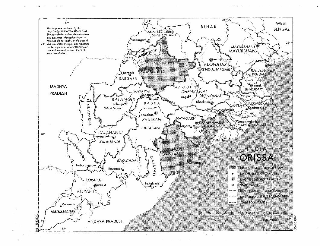
82' WEST
This map was produced by the ('K.. <B I H A R . WESTMap Design Unit of The World Bank. 5 UNDARGKRBNThe boundaries, colors, denominations SUNDERGA :and anyother information shown on ,r-.+., (this map do not imply, on the part of ,/Svndarg.rh c,'- _ , */ /
-22' TheWorldBankGroup,any judgment 1/ o0 k, _} ri do) 22'-on the legal status of any territory,or r 5 MAYU B HANJ r ! .any endorsement or acceptance of 4 r - ,'.
such boundaries. &hruaO AUBA
.~~ t$ ~~~< jKend~~uj rgar
C /</ r' - - . KEQNJHAR / war
L ,_sBMaLPUrga . $KENDUJHARGA I 5 ;*\Bargarh r >•AE W
BARGARH t ''MADHYA >AGL 3r
PRADESH so R DHENK)\ AJAL PUR Al>j~~~~~~ ~ ~~~~~~ p pur,' napuBALANO(IR Baud AAnI ) DWN$HAL %.Jpu
z B~~~aIangir~ BAUDA ~ AP A RJ a /' BALANGIR / "' sK
> U/_ -/'CUTTAc
>t Ma~~~~~~lkan fOr ,- .. .I... .1.... ~ ......... )/:.:--UIE:
~~& yiPhulabani \
208o v' HANDIR< NtRAD.S ..: :20-::: 4 }^S1t
m .-.~ K : : . : -- iPHULBANKALAHANDINULBAN garj
GADA01AM;4
IncI 0 Nabarangapur j, s Royagdado ' DSRCSELCEFOSTY
- y rr. 0 DIIDE DSTRCTCAPITL
~, KORAPT $ / NDIVDED DisTCTAPAS
41Koraput akj'-'tC41
KCRAPLHj IM- /I$ BtTnqolAlI~~~~~~~~~~~~~~~l & UDIVIDED DISyTRICT BUDRE
*Malkcongiri SAEBUDRE
A4ALKANGI I L. <-. 20 .~~~~~~~~~~~~~~ ~~~~~~~40 60 8010 120 140 160 KIOMETERS
ANDHRA PRADESH 2.~ioME82' 84~~~~~~~~~~~~~~~ . .~~~~~~~~~~ 86' .- S
Policy Research Working Paper Series
ContactTitle Author Date for paper
WPS2110 Life during Growth: international William Easterly May 1999 K. LabrieEvidence on Quality of Life and 31001Per Capita Income
WPS2111 Agricultural Land Reform in Postwar Toshihiko Kawagoe May 1999 P. KokilaJapan: Experiences and Issues 33716
WPS2112 Industrial Policy after the East Asian Ashoka Mody May 1999 S. KpundehCrisis: From 'Outward Orientation' 39591To New Internal Capabilities?
WPS2113 Wage Determination and Gender Stefano Paternostro May 1999 N. NouvialeDiscrimination in a Transition David E. Sahn 34514Economy. The Case of Romania
WPS2114 Economic Reforms and Total Factor Pablo Fajnzylber May 1999 S. HoltProductivity Growth in Latin Arnerica Daniel Lederman 37859And the Caribbean (I950-95):An Empirical Note
WPS2115 Foreign Investment and Productivity Simeon Djankov May 1999 R. VoGrowth in Czech Enterprises Bernard Hoekman 33722
WPS2116 Does Child Labor Displace Martin Ravallion May 1999 P. SaderSchooling? Evidence on Behavioral Quentin Wodon 33901Responses to an Enrollment Subsidy
WPS2117 On the Size and Number of Regional Soamiely Andriamananjara May 1999 L. TabadaIntegration Arrangements: A Political 36896Economy Model
WPS2118 Developing Countries and the Next Anne 0. Krueger May 1999 L. TabadaRound of Multilateral Trade 36896Negotiations
WPS2119 Tax Deductions, Environmental Ian Parry May 1999 R. YazigiPolicy, and the'Double Dividend' Antonio Bento 37176Hypothesis
WPS2120 Can Africa Export Manufactures? Ibrahim A. Elbadawi May 1999 C. BernardoThe Role of Endowment, Exchange 31148Rates, and Transactions Costs
WPS2121 Fiscal Management in Federal William Dillinger May 1999 A. LaraDemocracies: Argentina and Brazil Steven B. Webb 88148
WPS2122 Decentralization and Fiscal William Dillinger May 1999 S. WebbManagement in Colomnbia Steven B. Webb 38680

Policy Research Working Paper Series
ContactTitle Author Date for paper
WPS2123 Access to Land in Rural India Robin Mearns May 1999 G. Burnett82111
ci,