Social and Ecological Constraints on Decision Making … · mobility is important for the...
15
J. Mt. Sci. (2012) 9: 307–321 DOI: 10.1007/s11629-009-2320-8 307 Abstract: Transhumant pastoralism is an important activity in southern Morocco. Migration pattern of transhumant pastoralists can be affected by physical factors (e.g. droughts and diseases) or socioeconomic factors (e.g. schooling options for children and migration costs). We studied the spatio-temporal rangeland usage of the three tribes Ait Mgoun, Ait Zekri, and Ait Toumert in the south-central Atlas region with a two-fold approach. First, we tracked the migration movements of one representative transhumant herd using the Advanced Research and Global Observation Satellite (ARGOS) collars, which record coordinates from satellite signals. Second, we interviewed herders to obtain information about general grazing practices of the respective tribe and to gain more direct information on motivations underlying decisions. For each tribe we observed small-, medium- and large-scale movements. We found that the most important drivers of migration decisions were seasonal fodder availability and weather conditions in combination with herd-specific risk and cost assessment, as well as personal factors. In conclusion, general migration patterns vary in time, both between and within the tribes, but according to a regulatory framework. Moreover, it appears that both the customary rules and its flexible adaptation to physical constraints are generally beneficial in terms of conservation of the arid and semiarid rangeland resources. Key words: Ait Mgoun; Ait Zekri; Ait Toumert; ARGOS; Goat grazing; High Atlas; Jebel Saghro; Migration pattern; Rangeland; Small ruminant; Transhumance Introduction Livestock grazing occupies over a quarter of the terrestrial surface worldwide (Steinfeld et al. 2010). Extensive grazing systems of arid lands are often subject to overgrazing, leading to soil degradation (Steinfeld et al. 2010). Pastoral mobility is important for the management of the sparse dryland vegetation and the conservation of these fragile ecosystems (Koocheki and Gliessman 2005). However, the long-term continuation of pastoral mobility faces several obstacles such as the extension of crop farming and national or administrative borders (IIED and SOS Sahel 2010). In Morocco, 25 to 30% of small ruminants (sheep and goats) are kept in various mobile systems, from pure nomadism to short-distance summer transhumance (Bourbouze 2006). Nomads follow a seasonal migration pattern that can vary from year to year and do not create permanent settlements (Tegegne et al. 2009). They live exclusively on Social and Ecological Constraints on Decision Making by Transhumant Pastoralists: A Case Study from the Moroccan Atlas Mountains Zakia AKASBI 1,2 *, Jens OLDELAND 1 , Jürgen DENGLER 1 , Manfred FINCKH 1 1 Biodiversity, Evolution and Ecology of Plants, Biocentre Klein Flottbek and Botanical Garden, University of Hamburg, Ohnhorststr. 18, 22609 Hamburg, Germany 2 Institut Agronomique et Vétérinaire Hassan II, B.P. 6202 les instituts, 10000- Rabat, Morocco * Corresponding author, e-mail: [email protected] © Science Press and Institute of Mountain Hazards and Environment, CAS and Springer-Verlag Berlin Heidelberg 2012 Received: 1 February 2012 Accepted: 24 April 2012
Transcript of Social and Ecological Constraints on Decision Making … · mobility is important for the...

J. Mt. Sci. (2012) 9: 307–321 DOI: 10.1007/s11629-009-2320-8
307
Abstract: Transhumant pastoralism is an important activity in southern Morocco. Migration pattern of transhumant pastoralists can be affected by physical factors (e.g. droughts and diseases) or socioeconomic factors (e.g. schooling options for children and migration costs). We studied the spatio-temporal rangeland usage of the three tribes Ait Mgoun, Ait Zekri, and Ait Toumert in the south-central Atlas region with a two-fold approach. First, we tracked the migration movements of one representative transhumant herd using the Advanced Research and Global Observation Satellite (ARGOS) collars, which record coordinates from satellite signals. Second, we interviewed herders to obtain information about general grazing practices of the respective tribe and to gain more direct information on motivations underlying decisions. For each tribe we observed small-, medium- and large-scale movements. We found that the most important drivers of migration decisions were seasonal fodder availability and weather conditions in combination with herd-specific risk and cost assessment, as well as personal factors. In conclusion, general migration patterns vary in time, both between and within the tribes, but according to a regulatory framework. Moreover, it appears that both the customary rules and its flexible adaptation to physical constraints are generally beneficial in terms of conservation of the arid and semiarid rangeland
resources. Key words: Ait Mgoun; Ait Zekri; Ait Toumert; ARGOS; Goat grazing; High Atlas; Jebel Saghro; Migration pattern; Rangeland; Small ruminant; Transhumance
Introduction
Livestock grazing occupies over a quarter of the terrestrial surface worldwide (Steinfeld et al. 2010). Extensive grazing systems of arid lands are often subject to overgrazing, leading to soil degradation (Steinfeld et al. 2010). Pastoral mobility is important for the management of the sparse dryland vegetation and the conservation of these fragile ecosystems (Koocheki and Gliessman 2005). However, the long-term continuation of pastoral mobility faces several obstacles such as the extension of crop farming and national or administrative borders (IIED and SOS Sahel 2010). In Morocco, 25 to 30% of small ruminants (sheep and goats) are kept in various mobile systems, from pure nomadism to short-distance summer transhumance (Bourbouze 2006). Nomads follow a seasonal migration pattern that can vary from year to year and do not create permanent settlements (Tegegne et al. 2009). They live exclusively on
Social and Ecological Constraints on Decision Making by
Transhumant Pastoralists: A Case Study from the Moroccan
Atlas Mountains
Zakia AKASBI1,2*, Jens OLDELAND1, Jürgen DENGLER1, Manfred FINCKH1
1 Biodiversity, Evolution and Ecology of Plants, Biocentre Klein Flottbek and Botanical Garden, University of Hamburg, Ohnhorststr. 18, 22609 Hamburg, Germany
2 Institut Agronomique et Vétérinaire Hassan II, B.P. 6202 les instituts, 10000- Rabat, Morocco
* Corresponding author, e-mail: [email protected]
© Science Press and Institute of Mountain Hazards and Environment, CAS and Springer-Verlag Berlin Heidelberg 2012
Received: 1 February 2012 Accepted: 24 April 2012
J. Mt. Sci. (2012) 9: 307–321
308
livestock rearing (Werner 2004). Transhumants practice seasonal mobility with their livestock between fixed summer and winter pastures (Blench 2001). They also practice crop cultivation and have permanent settlements (Tegegne et al. 2009).
In southern Morocco, about 93% of the Draa catchment area is used as rangeland by mobile and sedentary pastoralists (Finckh and Goldbach 2010). The principal livelihood activity in this region is pastoralism and irrigation agriculture. The pastoralists have customary land-use rules regulating grazing rights between and within tribes (Saqalli et al. 2002). A very common management tool is the Agdal, which is a collective property used by the tribes. These have boundary limits, as well as opening and closing dates fixed by customary rules (Ilahiane 1999). Mobile pastoralism suffers from several problems, the most acute of which is the perpetual loss of rangeland surface due to the increasing sharing of communal land between different ethnic groups for cropping purposes (Werner 2004) and politically driven sedentarization (Chiche 2007). The transhumant pastoralists believe that pastoral resources have become degraded over the last 20 years due to drought (SENS 2005). Another problem is the lack of coincidence between communal boundaries and tribal territories (Finckh & Kirscht 2008; Rössler et al. 2010). This spatial incongruity is a key obstacle for sustainable rangeland management.
Despite several studies conducted in this region (Saqalli et al. 2002; Werner 2004; Kemmerling 2008; Bauman 2009; Freier et al. in press a), there is a lack of knowledge about the drivers of decision making on the how, if and when of transhumants’ migration. Most relevant studies are unpublished reports, while published work only describes generalized migrations or focuses on single tribes. By contrast, we conducted a study with spatially explicit data for transhumant migrations and discussed the drivers behind individual decisions. Furthermore, we compared migration patterns between three neighbouring tribes with different ecological conditions relating to the spatial extension of summer, transition and winter pastures.
The aim of this paper was to outline the social and ecological framework for decision making by mobile pastoralists, based on a conceptual spatial
estimate of rangeland and seasonal fodder availability for transhumant herders, and climatic constraints. We discussed the decisions of selected herders of the tribes Ait Mgoun, Ait Zekri and Ait Toumert against this background. We were especially interested in the degree of freedom for their individual decisions and the main reasons behind them. For this purpose, we combined semi-quantitative tracking data to follow the trajectory of selected herds within the year, with structured interviews to assess the general validity of our observations. Our results on the drivers and constraints that are influencing decision making by mobile pastoralists regarding spatio-temporal pasture selection help to improve strategies for rangeland management. Based on our results we also discussed the utility of the two chosen methodological approaches, alone or combined, to provide convincing answers to the questions addressed.
1 Methods
1.1 Study area
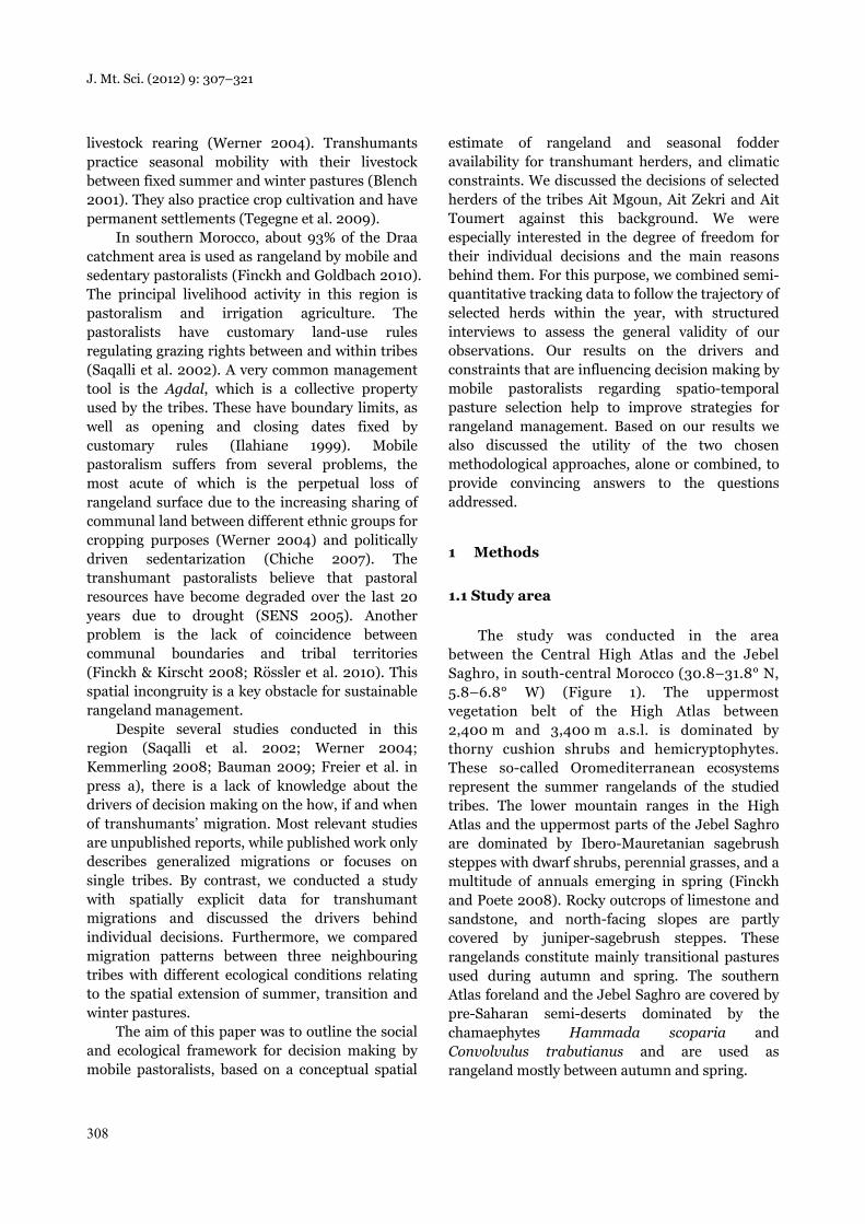
The study was conducted in the area between the Central High Atlas and the Jebel Saghro, in south-central Morocco (30.8–31.8° N, 5.8–6.8° W) (Figure 1). The uppermost vegetation belt of the High Atlas between 2,400 m and 3,400 m a.s.l. is dominated by thorny cushion shrubs and hemicryptophytes. These so-called Oromediterranean ecosystems represent the summer rangelands of the studied tribes. The lower mountain ranges in the High Atlas and the uppermost parts of the Jebel Saghro are dominated by Ibero-Mauretanian sagebrush steppes with dwarf shrubs, perennial grasses, and a multitude of annuals emerging in spring (Finckh and Poete 2008). Rocky outcrops of limestone and sandstone, and north-facing slopes are partly covered by juniper-sagebrush steppes. These rangelands constitute mainly transitional pastures used during autumn and spring. The southern Atlas foreland and the Jebel Saghro are covered by pre-Saharan semi-deserts dominated by the chamaephytes Hammada scoparia and Convolvulus trabutianus and are used as rangeland mostly between autumn and spring.
J. Mt. Sci. (2012) 9: 307–321
309
Figure 1 Location of the study area between the Central High Atlas and the Anti-Atlas in southern Morocco.The study area is divided into three major vegetation zones. A digital elevation model is displaying thetopography within the region in a grey scale.
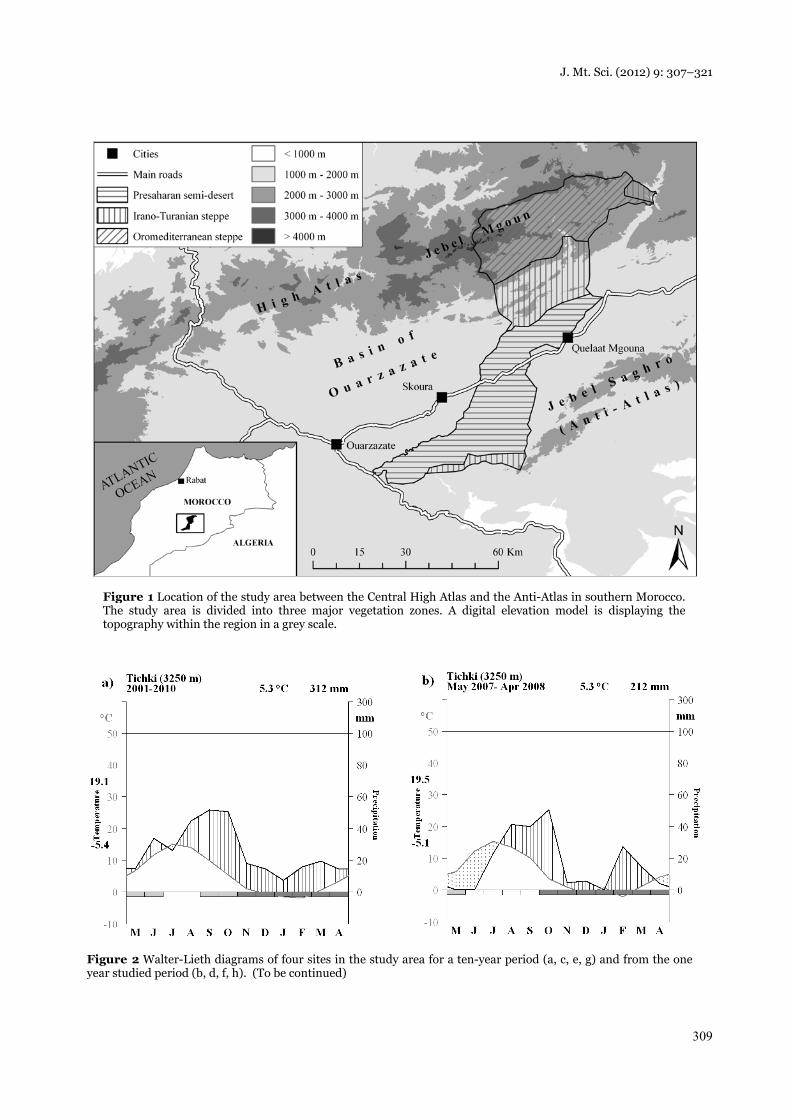
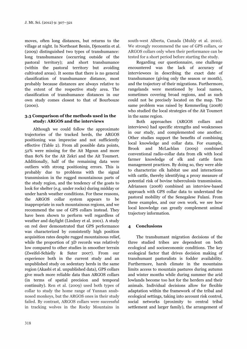
Figure 2 Walter-Lieth diagrams of four sites in the study area for a ten-year period (a, c, e, g) and from the oneyear studied period (b, d, f, h). (To be continued)

J. Mt. Sci. (2012) 9: 307–321
310
(Continued) Figure 2 Walter-Lieth diagrams of four sites in the study area for a ten-year period (a, c, e, g) and fromthe one year studied period (b, d, f, h). Notes: The numbers above the figures represent the mean annual temperature and the mean annual precipitation.The black curve represents precipitation in millimeters and the grey curve represents temperature in degree Celsius.Dotted areas represent an arid season, while the area with bars represents a humid season. The upper number on theleft y-axis equals the mean daily maximum temperature of the warmest month, and the lower number the meandaily minimum temperature of the coldest month. The rectangles below the x-axis represent the period of sure frost(dark grey) and a period of probable frost (light grey). Note that the sequence of months in the diagrams starts withMay, deviating from normal Walter-Lieth diagrams.

J. Mt. Sci. (2012) 9: 307–321
311
The region is characterized by high climatic variability in time and space (Fink et al. 2008). The bioclimates range from sub-humid in the High Atlas to arid in the Basin of Ouarzazate and the Jebel Saghro (Oldeland et al. 2008). The mean annual precipitation varies between more than 565 mm in the High Atlas and less than 135 mm in the Atlas foreland (Figure 2). The mean annual temperature varies from 5.3 °C in Tichki to more than 18 °C in Bou Skour (Schulz 2008; see Figure 2).
1.2 Interviews with herdsmen
We conducted 29 structured interviews with transhumant herders from the three tribes inhabiting the region: Ait Mgoun, Ait Zekri and Ait Toumert. The interviews were conducted between November 2008 and June 2009, either at the transhumant’s camp in the easily accessible pastures or at the weekly market visited by a high number of transhumant pastoralists. The interviews were carried out in the Arabic language and when necessary in the local language, Tachelhit, with the help of an interpreter. The questions focused on the number of animals owned by the transhumant pastoralist, the trajectories of seasonal migrations, the periods spent in each
pasture and the factors influencing decisions on the direction of transhumance (Appendix 1). The transhumant pastoralists in the three tribes are organized in transhumant associations. Therefore, we collected general information about the tribes by interviewing the chairmen of these associations.
For the sake of convenience, we classified the annual movements of the transhumant pastoralists of the region into four categories: semi-sedentary (less than 20 km), short-distance transhumance (20–40 km), medium-distance transhumance (40–100 km), and long-distance transhumance (more than 100 km).
1.3 Satellite tracking of herds
We selected one transhumant herd from each of the three studied tribes for animal tracking. Generally, the herds in the study area consist of small ruminants (goats and sheep) and a small number of dromedaries and equids (mules and donkeys) used for transporting tents and baggage during migration and for fetching water. The tracked herds consisted only of goats and were guided by herdsmen (Table 1). The transhumant pastoralists guide their herds in pastures surrounding a series of temporary camps within their rangelands (Table 1).
Table 1 General data on the studied tribes and herds
Tribe
Ait Mgoun Ait Zekri Ait Toumert
Number of goats in the tracked herd
600 220 600
Village of the tracked herd El Mrabitine (High Atlas, 2,900 m a.s.l.)
Azaghar n’Oughyoule (Jebel Saghro, 1,400 m a.s.l.)
Ait Toumert (High Atlas, 1,900 m a.s.l.)
Rangeland area (Chiche 2003) From the ridge line of the High Atlas to the Dades Valley
From the summit of the High Atlas down to the central Jebel Saghro
Buffer zone between the territories of the Ait Zekri and the Ait Mgoun
Placement of permanent settlements (own observation)
Mostly in high and mid-altitudes (High Atlas)
From high to low altitudes (High Atlas) + Jebel Saghro
Mostly in mid-altitudes (High Atlas)
Table 2 Daily ARGOS collar records from the three herds
Tribes
Ait Mgoun Ait Zekri Ait Toumert
Measured period 24 April 2007–23 March 2008
24 April 2007–26 April 2008
26 April 2007–21 April 2008
Missing records 176 298 305
Number of outliers 120 53 32
Available records 91 50 40
J. Mt. Sci. (2012) 9: 307–321
312
We used ARGOS (Advanced Research and Global Observation Satellite) transmitter collars (model 5035 PTT, Habit Research Ltd. (Victoria, BC, Canada)) on a single goat from each herd to follow the trajectory of the herds. The collar sends signals to the ARGOS Satellite System on the x, y, z positions (i.e. longitude, latitude, and altitude) of the goat, and these can be subsequently downloaded from a website. The satellite transmits signals during four hours per day and allows one record per day. However, days without position fixes were frequent in some periods due to satellite transmission problems (Table 2), most probably due to the rugged terrain of the study zone. In an earlier trial with the Ait Toumert herd, we used a GPS collar for the month of April 2007 on the same goat that later carried the ARGOS collar.
In a pre-study, we additionally used a GPS PLUS-1 Store On Board Collar from Vectronic Aerospace (Berlin, Germany) on three goats from three different herds. The GPS collar recorded the x/y/z-coordinates of the goat (i.e. latitude, longitude, and altitude) every two hours from 6:00 to 22:00. This was to assess the areal extent and the grazing radius of the transhumant herd used around a camp.
1.4 Data analysis
We visualized and checked the ARGOS data using ArcGIS 9.3 (ESRI 2010). We removed records judged to be incorrect outliers (Table 2) on the basis of a distance > 20 km to either the previous or next day’s location. No such outliers occurred for the GPS collar.
The results of the pre-study showed that the grazing patterns were similar to those found around stables of sedentary herds of the region (Akasbi et al. unpublished data), with a maximum distance of 3,000 m from the stable being covered by the herds (Appendix 2). To model the rangelands available for transhumant herds, we thus used spatial buffers of 3,000 m around all villages in the study area. The areas within the buffers were considered as the main territory for sedentary herd use because mobile herders try to avoid competition with village herds. The areas outside the buffers were considered out of reach of village herds and therefore exclusively used by transhumant pastoralists.
For each herd, we created polygons representing the different pastures visited during the year. We chose the points matching a successive time sequence in the same area and then created a minimum convex polygon around them. We obtained the tribal territories from a previous study (Projet CBTHA 2008). Information on the vegetation zones in the study area was taken from Finckh and Oldeland (2008). In order to understand the distribution of rangelands available for each tribe in each vegetation type, we calculated the area available per tribe in the different ecological zones by intersecting the tribal territories and the vegetation belts in the GIS.
2 Results
2.1 Rangeland distribution in the territories of the tribes
In terms of the number of transhumant pastoralists and animals, the Ait Mgoun is the biggest tribe, followed by the Ait Zekri and the Ait Toumert (Table 3). The rangelands of the Ait Mgoun and the Ait Zekri are more than twelve times larger than those of the Ait Toumert (Table 4). Rangelands accessible by the transhumant herds are larger than those accessible by the sedentary herds within each of the three tribes. This situation is more pronounced in the case of the Ait Zekri, where the transhumants’ rangelands are four times larger than the ones of the sedentary herds. Regarding vegetation, most of the rangelands of the Ait Mgoun and the Ait Toumert belong to the Oromediterranean zone of high altitudes, while most of those of the Ait Zekri are in the semi-desert (Table 4).
2.2 Interview analyses regarding migration patterns
Migration patterns of the transhumant pastoralists depended firstly on the tribal territory and grazing rights of each tribe (Table 3). During the period of investigation, all the interviewed pastoralists spent the summer season in their tribe-specific Agdals, but this was not necessarily so in the other seasons. For the Ait Mgoun, 77% of the interviewed transhumants practice long-distance

J. Mt. Sci. (2012) 9: 307–321
313
migrations from the High Atlas to the Jebel Saghro, especially during rainy years with good development of annual vegetation, while 23% practice a medium-distance trajectory from the high mountains to the plain of Imlil in the Atlas foreland. They spend the transition period in the sagebrush steppes of Timassine and eastern Azaghar n’Igher. Short-distance transhumance trajectories are generally preferred in dry years. From the interviewed Ait Zekri, 63% travel the long distance between the Jebel Saghro and the high mountains, 27% practice semi-sedentary movements within the Jebel Saghro, while the other 10% practice short- to medium-distance journeys between the high mountains and the mid-altitude plain of Azaghar n’Igher. Within the Ait Zekri, we found two groups. In wet years with good fodder availability, the transhumant pastoralists originating from Jebel Saghro sometimes prefer semi-sedentary movements in Jebel Saghro, which offers extended rangelands with high quality
fodder plants. Here, the animals are reported to be healthy and grow better. They migrate to the High Atlas in summer mostly in dry years when the available forage in Jebel Saghro is not sufficient. The second group of transhumants originating from the High Atlas prefer short- to medium-distance transhumance in dry years. Within the Ait Toumert, 12% practice long-distance transhumance between the high mountains (Agdal Awajgal) in summer and the Jebel Saghro, but only in a cold and rainy winter. Meanwhile, 88% practice only a short- to medium-distance migration between the high mountains and the plains of Imlil or Timassinine. They spend the transition period in the Jebel Asselda.
2.3 Annual migration pattern of the tracked herds
The ARGOS data showed that the Ait Mgoun transhumant migrated with his herd between the
Table 3 Transhumant herds of the three studied tribes and their rangelands (results from our interviews)
Tribes
Ait Mgoun Ait Zekri Ait Toumert
Number of transhumants 194 84 29
Total number of sheep and goats
> 100,000 > 30,000 > 18,800
Summer rangeland Agdal Ouzighimt in the Jebel Mgoun
Agdals Tiguitim and Marat in the Jebel Mgoun and Jebel Aklim
Agdal Awajgal in the Jebel Mgoun
Transition rangeland Plains of Azaghar n’Igher and Timassinine
The plains of Timassinine and Azaghar n’Igher
Jebel Asselda
Winter rangeland Jebel Saghro or Imlil Jebel Saghro and Imlil The plains of Imlil, Timassinine, Jebel Saghro
Table 4 Percentage of the area per tribe, sedentary and transhumant herds for each vegetation type in the study area
Tribes
Ait Mgoun Ait Zekri Ait Toumert
Vegetation types S T All S T All S T All
Oromediterranean zone (%) 24.9 63.4 49.0 19.5 4.5 7.3 65.4 99.1 81.7
Irano-Turanian steppe with Artemisia (%)
46.9 21.8 31.3 19.3 18.1 18.27 34.5 0.9 18.3
Semi-desert with Hammada scoparia (%)
28.2 14.7 19.8 61.2 77.4 74.3 0 0 0.0
Total (ha) 50,845 85,347 136,192 22,905 98,893 121,798 4,941 4,654 9,595
S= Sedentary; T= Transhumant.
J. Mt. Sci. (2012) 9: 307–321
314
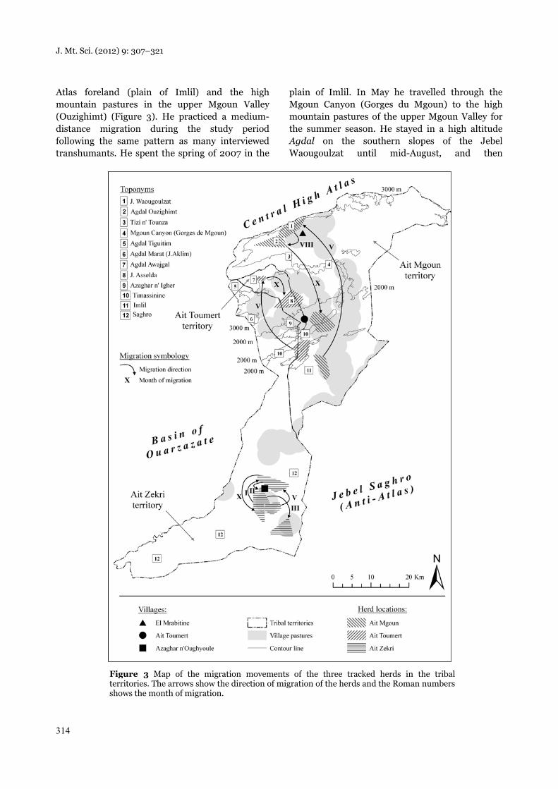
Atlas foreland (plain of Imlil) and the high mountain pastures in the upper Mgoun Valley (Ouzighimt) (Figure 3). He practiced a medium-distance migration during the study period following the same pattern as many interviewed transhumants. He spent the spring of 2007 in the
plain of Imlil. In May he travelled through the Mgoun Canyon (Gorges du Mgoun) to the high mountain pastures of the upper Mgoun Valley for the summer season. He stayed in a high altitude Agdal on the southern slopes of the Jebel Waougoulzat until mid-August, and then
Figure 3 Map of the migration movements of the three tracked herds in the tribalterritories. The arrows show the direction of migration of the herds and the Roman numbersshows the month of migration.

J. Mt. Sci. (2012) 9: 307–321
315
descended to lower altitudes close to the valley bottom west of El Mrabitine, where he stayed until October. In mid-October, he crossed the high mountain passes of Tizi n’ Tounza and descended to mid-altitude rangelands of Timassinine in the Atlas foreland, where he spent the winter and spring of 2008. In conclusion, this transhumant spent the spring of 2007 and 2008 in two different ecological zones: Imlil in the pre-Saharan semi-deserts and Timassinine in the Irano-Turanian sagebrush steppes.
The Ait Zekri transhumant stayed in the semi-desert pastures of Jebel Saghro during the whole study period, following a semi-sedentary movement. This contrasted with the normal pattern of migrating in summer towards the High Atlas (Figure 3). During the year, he shifted his camp five times searching for good pastures. The movements of his herd were limited to a relatively small area of less than 20 km from his village of origin, and twice in the observation period he returned for a while to his permanent house (June – September 2007 and February 2008).
The Ait Toumert transhumant followed a medium-distance trajectory, like most of the Ait Toumert. In spring 2007, he guided his herd in mid-altitude sagebrush steppes in the territory of the Ait Mgoun and the Ait Zekri south of the village of Ait Toumert, which is where he has a house. In May 2007, he moved from there to the high mountain Agdal Awajgal, on the southern slope of the Jebel Mgoun (4,060 m a.s.l.), where he spent the summer season. In October, he descended to the Jebel Asselda in the lower Oromediterranean zone, directly north-west of Ait Toumert, for the winter of 2007/2008 (Figure 3). Again, as in the case of the Ait Mgoun herder, he spent the winter of 2008 in a different, higher-situated, pasture than in the winter of 2007.
3 Discussion
3.1 Ecological and social factors shaping the migration patterns
We aimed to identify the relevant ecological and social factors that influence decision making of herders in the Atlas Mountains of southern Morocco. We found five major factors, which are
discussed in the following paragraphs, bringing together the results of our two partial studies, the interviews, and the satellite tracking of the herds.
3.1.1 Fodder availability
The transhumants choose their pastures according to fodder availability and quality in order to meet the needs of their animals. This is supported by the observed trajectories of the transhumants as well as by the interviews. The Oromediterranean high mountain pastures are dominated by perennial plants, being reliably productive during the summer months and offering high quality fodder for the animals. When the high mountain Agdals open in mid-May, the pastures have rested for the whole winter and a good part of the spring, giving the vegetation enough time to recover from the last grazing season. Moreover, summer migration to the high mountain pastures allows the mid- and low-altitude steppes to recover after the spring grazing season, with their plant-life left to resprout relatively undisturbed after the first autumn rains. Such transhumance patterns, driven by fodder availability, are found throughout the world. In Tanzania, Maasai herders are well aware which landscapes are most productive in a particular season (Oba and Kaitira 2006). In the floodplain in Cameroun, the pastoralists practice a transhumance following the rain and looking for fresh forage for their animals, a strategy called ‘watching the clouds’ (Moritz et al. 2010). Similarly, In Iran the Komachi transhumants migrate seasonally from lowland winter pastures on the coastal plains of the south of the country to highland summer pastures close to the city of Kerman, following the availability of needed resources (Salzman 2002). Hence, for nearly all transhumants, fodder availability is the key factor for making decisions on where to take their herds. These patterns are usually adapted to seasonal weather conditions coupled with a resting system for the vegetation.
3.1.2 Harsh climate
Harsh climates can influence transhumance behaviour by limiting usability or even accessibility of certain parts of the study region. Seasonal vertical migration is a good strategy to avoid the severe cold winters in the high mountains and the hot summers at lower altitudes, which in both
J. Mt. Sci. (2012) 9: 307–321
316
cases can otherwise impact negatively on the transhumants and their animals alike. At high altitudes, winter mean temperatures descend below 0 °C (Figure 2a-b) and there is the risk of getting trapped with the herds by longer-lasting snow cover. The mean temperature at lower-lying pastures is about 10 °C in the winter. By contrast, in summer the climatic conditions are comfortable in the high mountains with mean temperatures between 10 °C and 18 °C, compared to mean temperatures reaching more than 30 °C in the basin of Ouarzazate and in the Jebel Saghro (Figure 2a-b, g-h). In Morocco, this transhumance, either in the vertical or horizontal direction, was also observed in other regions such as the Middle Atlas, eastern Moroccan High Plateaus and southern Moroccan desert (Bourbouze 2000). In mountainous countries, this seasonal vertical migration is a well-known strategy. Until the 1930s it was practiced in Kyrgyzstan, where the nomads used to spend the summer in the mountainous pastures and descended to lower altitudes in winter because of low temperatures and snow (Borchardt et al. 2011). The same patterns have been observed in Tibet (Dupuis 1970), Abruzzo in central Italy (Morbidini 2002), and South Africa (Samuels et al. 2008). It seems that harsh climates, with their unbearable cold or hot weather conditions for the transhumants and their herds, are an important factor driving decisions on their vertical seasonal migration.
3.1.3 Grazing rights
Tribal boundaries limit the grazing rights of each tribe and thus act as a social constraint on the spatial expansion of the migration patterns. The transhumants generally prefer to graze within their tribal territory, and according to their grazing rights. This avoids conflicts with other tribes, or helps gain support in case of conflicts. However, sometimes tribes have seasonal grazing rights in the tribal territory of other tribes. For example, the Ait Mgoun are allowed to graze in the Jebel Saghro even though it belongs to the Ait Zekri territory, following an agreement between both tribes in 1950 (Chiche 2003). For this reason, many Ait Mgoun herders migrate to this pasture in winter. The Ait Toumert transhumants are also allowed to graze their animals during winter in the territory of the other two tribes because of their historically
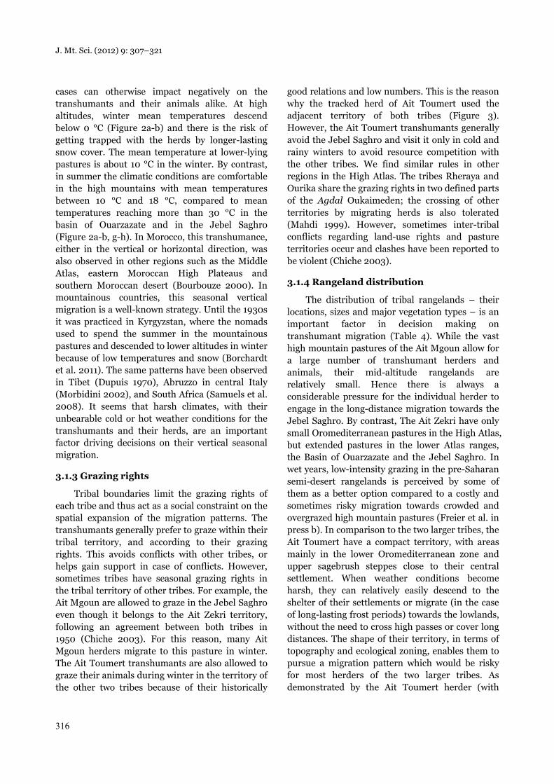
good relations and low numbers. This is the reason why the tracked herd of Ait Toumert used the adjacent territory of both tribes (Figure 3). However, the Ait Toumert transhumants generally avoid the Jebel Saghro and visit it only in cold and rainy winters to avoid resource competition with the other tribes. We find similar rules in other regions in the High Atlas. The tribes Rheraya and Ourika share the grazing rights in two defined parts of the Agdal Oukaimeden; the crossing of other territories by migrating herds is also tolerated (Mahdi 1999). However, sometimes inter-tribal conflicts regarding land-use rights and pasture territories occur and clashes have been reported to be violent (Chiche 2003).
3.1.4 Rangeland distribution
The distribution of tribal rangelands – their locations, sizes and major vegetation types – is an important factor in decision making on transhumant migration (Table 4). While the vast high mountain pastures of the Ait Mgoun allow for a large number of transhumant herders and animals, their mid-altitude rangelands are relatively small. Hence there is always a considerable pressure for the individual herder to engage in the long-distance migration towards the Jebel Saghro. By contrast, The Ait Zekri have only small Oromediterranean pastures in the High Atlas, but extended pastures in the lower Atlas ranges, the Basin of Ouarzazate and the Jebel Saghro. In wet years, low-intensity grazing in the pre-Saharan semi-desert rangelands is perceived by some of them as a better option compared to a costly and sometimes risky migration towards crowded and overgrazed high mountain pastures (Freier et al. in press b). In comparison to the two larger tribes, the Ait Toumert have a compact territory, with areas mainly in the lower Oromediterranean zone and upper sagebrush steppes close to their central settlement. When weather conditions become harsh, they can relatively easily descend to the shelter of their settlements or migrate (in the case of long-lasting frost periods) towards the lowlands, without the need to cross high passes or cover long distances. The shape of their territory, in terms of topography and ecological zoning, enables them to pursue a migration pattern which would be risky for most herders of the two larger tribes. As demonstrated by the Ait Toumert herder (with

J. Mt. Sci. (2012) 9: 307–321
317
ARGOS observation), the compact Ait Toumert territory allows their transhumants to pass the winter in relatively high pastures. In the case of bad weather, they only have a short distance to the village Ait Toumert to look for shelter or to buy additional fodder. The proximity of the pastures to their main tribal centre is most important for reducing the immediate risk of calamities, but is not a long-time option for cold winters. This is shown again by the fact that the Ait Toumert herder spent the hard winter of 2006/2007 at considerably lower pastures than the milder winter of 2007/2008.
3.1.5 Individual factors and social networks
Migration patterns of herders are also influenced by social factors and networks. Summer migration allows the Ait Mgoun herders to visit their families and to reconnect with their tribal fraction. The Ait Mgoun transhumant tracked by the ARGOS satellite preferred a mid-distance rather than long-distance transhumance in the observation period. He stayed half-way between the mountain villages and the main tribal settlement and souk at Quelaat Mgouna, remaining well connected to relatives and avoiding the risks and costs of long-distance travel between his village and the Jebel Saghro (Freier et al. in press b). Many Ait Mgoun transhumants tend to spend the winter in the plain of Imlil, close to the main market town Quelaat Mgouna, while the Ait Toumert descend in autumn towards their villages and their weekly market where they can buy or sell animals. In spring, tribal members warned the Ait Zekri transhumant in the ARGOS study about cases of the blue tongue disease in the Atlas villages of the tribe. Therefore, the transhumant cancelled the long migration towards the Atlas high mountain pastures, opting for short migrations within the Jebel Saghro and around his home village. In this way, he avoided the risk of his animals becoming diseased and the costs of the long journey towards the High Atlas. In African pastoral systems, reciprocal livestock exchange either through friendships, loans or gifts is a typical strategy against the risk of losing animals as a result of threats such as drought and diseases, at the same time contributing to the rebuilding of herds (Moritz et al. 2011). The Ait Zekri transhumant returned to his house twice, during the hottest and coldest
periods of the year, to benefit from some weeks of relative comfort and convenience. Over the course of the year he guided his herd close enough to the “road” to enable him or his son to visit the weekly souk at Skoura. This also meant he could go to his village every week for Friday prayers (and the corresponding exchange of news from family and tribal fraction). The same strategy was followed by the Ait Toumert herder. From autumn to spring he would always graze close to his village, so that he was able to visit the weekly souk at Ait Toumert for provisioning, news exchange and a visit to his house. Such behaviour shows how herders rely strongly on their family and tribal networks.
3.2 Patterns of transhumance in comparison with other regions
In this study, we classified transhumant migrations into four categories: long-, medium-, and short-distance, and semi-sedentary. However, there is no unified terminology for types of transhumance. Pastoral migrations have been classified according to distances covered, periodicity, duration of departure, location, and type of livestock, as well as by combinations of these aspects (Clarke 1959). Moreover, the differentiation between long- and short-distance transhumance varies according to the macro-regional context. In North Cameroun, Kossoumna Liba’a (2008) considered cattle grazing up to 5 km away from villages as short-distance transhumance while she classified long-distance as being between 20 and 100 km. In Romania, Huband et al. (2010) used the term long-distance transhumance for sheep that covered distances of 200–300 km. However, even longer-distance migrations of more than 1,000 km are documented. In this case, the herders cross province or even country borders, especially during severe droughts (Werner 2004).
Some authors do not classify transhumance by distance only. In the Maghrebian context, Bourbouze (2000) defined three major types of pastoralism based on their mobility: semi-nomadism, called also long transhumance (migration of the family with the herd over distances of more than 100 km and using tents); short transhumance, or summer transhumance, when movements are made towards mountainous pastures in summer; and sedentary, when the herd
J. Mt. Sci. (2012) 9: 307–321
318
moves, often long distances, but returns to the village at night. In Northeast Benin, Djenontin et al. (2009) distinguished two types of transhumance: long transhumance (occurring outside of the pastoral territory); and short transhumance (within the pastoral territory but avoiding cultivated areas). It seems that there is no general classification of transhumance distance, most probably because distances are always relative to the extent of the respective study area. The classification of transhumance distances in our own study comes closest to that of Bourbouze (2000).
3.3 Comparison of the methods used in the study: ARGOS and the interviews
Although we could follow the approximate trajectories of the tracked herds, the ARGOS positioning was imprecise and not sufficiently effective (Table 2). From all possible data points, 52% were missing for the Ait Mgoun and more than 80% for the Ait Zekri and the Ait Toumert. Additionally, half of the remaining data were outliers with strong positioning errors. This is probably due to problems with the signal transmission in the rugged mountainous parts of the study region, and the tendency of the goats to look for shelter (e.g. under rocks) during midday or under harsh weather conditions. For these reasons, the ARGOS collar system appears to be inappropriate in such mountainous regions, and we recommend the use of GPS collars instead. They have been shown to perform well regardless of weather and daylight (Lindzey et al. 2001). A study on red deer demonstrated that GPS performance was characterized by consistently high position acquisition rates despite rugged mountainous relief, while the proportion of 3D records was relatively low compared to other studies in smoother terrain (Zweifel-Schielly & Suter 2007). From our experience both in the current study and an unpublished study on sedentary herds in the same region (Akasbi et al. unpublished data), GPS collars give much more reliable data than ARGOS collars (in terms of spatial precision and temporal continuity). Ren et al. (2009) used both types of collar to study the home range of Yunnan snub-nosed monkeys, but the ARGOS ones in their study failed. By contrast, ARGOS collars were successful in tracking wolves in the Rocky Mountains in
south-west Alberta, Canada (Muhly et al. 2010). We strongly recommend the use of GPS collars, or ARGOS collars only when their performance can be tested for a short period before starting the study.
Regarding our questionnaire, one challenge encountered was the lack of accuracy of interviewees in describing the exact date of transhumance (giving only the season or month), and the trajectory of their migrations. Furthermore, rangelands were mentioned by local names, sometimes covering broad regions, and as such could not be precisely located on the map. The same problem was raised by Kemmerling (2008) who studied the local strategies of the Ait Toumert in the same region.
Both approaches (ARGOS collars and interviews) had specific strengths and weaknesses in our study, and complemented one another. Other studies support the benefits of combining local knowledge and collar data. For example, Brook and McLachlan (2009) combined conventional radio-collar data from elk with local farmer knowledge of elk and cattle farm management practices. By doing so, they were able to characterize elk habitat use and interactions with cattle, thereby identifying a proxy measure of potential risk of bovine tuberculosis transmission. Adriansen (2008) combined an interview-based approach with GPS collar data to understand the pastoral mobility of the Senegalese Fulani. From these examples, and our own work, we see how local knowledge can greatly complement animal trajectory information.
4 Conclusions
The transhumant migration decisions of the three studied tribes are dependent on both ecological and socioeconomic conditions. The key ecological factor that drives decision making of transhumant pastoralists is fodder availability. Furthermore, harsh climate in the mountains limits access to mountain pastures during autumn and winter months while during summer the arid lowlands become too hot for the herders and their animals. Individual decisions allow for flexible adaptation within the framework of the tribal and ecological settings, taking into account risk control, social networks (proximity to central tribal settlement and larger family), the arrangement of
J. Mt. Sci. (2012) 9: 307–321
319
tribal territories and access to local markets. The findings based on our ARGOS trajectories were in agreement with the general migration framework deduced from the interviews with the transhumants. Both methods, interviews and ARGOS trajectories, had certain weaknesses, in particular with regard to spatial precision. However, we found that in our case study, both methods were complementing each other. This comprehensive study of migration patterns of transhumant pastoralists and the factors that influence their decisions may provide valuable information to rangeland managers of semi-arid rangelands.
Acknowledgements
The ARGOS collar study was designed and carried out by Manfred Finckh, while Zakia Akasbi
undertook the interview study. All authors jointly planned the concept of the paper and the analyses. The GIS analyses and the maps were done by Zakia Akasbi, Jens Oldeland, and Manfred Finckh. The writing-up of the paper was led by Zakia Akasbi, while all authors revised the full text. The study was conducted within the framework of BIOTA Maroc, funded by the German Federal Ministry of Research and Education (Grant no. 01 LC 0601A). We are grateful to all transhumant herders for their participation and patience in the interviews, and Mhamed El Inani for help with the translation in the interviews, while we would like to thank Will Simonson for language editing. The University of Hamburg (MIN-Fakultät) supported Zakia Akasbi with a research scholarship within the Proexzellenzia programme. Lastly, we are grateful to the two anonymous referees and the editors whose comments significantly contributed to the improvement of the article.
Appendix 1 Model of interviews conducted with the transhumant herders
N° Interview
1) Date
2) Name of the herder
3) Name of the village
4) Tribe of the herder
5) Number of sheep
6) Number of goats
7) Number of dromedaries*
8) Number of equines*
9) Number of sold animals*
10) Age of sold animals*
11) Sheep price*
12) Goat price*
13) Dromedary price*
14) Do you sell wool? For how much? *
15) Who is responsible for herding?
16) Where do you sell the animals (which markets)
17) Period of selling the animals*
18) Name of summer rangeland used, period spent there
19) Winter rangeland, period spent there
20) Transition rangeland, period spent there
21) Is this trajectory of transhumance the same every year?
22) Under which conditions you change the usual direction of transhumance?
23) Which are the most important factors for your decision making about migration routes?
*Data not used because they were not complete or imprecise.

J. Mt. Sci. (2012) 9: 307–321
320
References
Adriansen HK (2008) Understanding pastoral mobility: the case of Senegalese Fulani. The Geographical Journal 174: 207–222.
Akasbi Z, Oldeland J, Jürgen D, Finckh M (unpublished data).Advances in the analysis of GPS tracks to assess grazing pattern and intensity: a case study on goats in southern Morocco.
Bauman G (2009) How to assess rangeland condition in semiarid ecosystems? The indicative value of vegetation in the High Atlas Mountains, Morocco. PhD thesis. University of Cologne, Cologne. p 149.
Blench R (2001) You can’t go home again: pastoralism: Pastoralism in the new millennium. FAO. London. Available online: http://www.odi.org.uk/work/projects/pdn/eps.pdf (Accessed on 22 January 2012).
Bourbouze A (2000) Pastoralism in North Africa: the silent revolution. Fourrages 161: 3–21. (In French).
Bourbouze A (2006) Livestock systems and animal production in North African steppes: A new reading of the pastoral society in the Maghreb. Sécheresse 17: 31–39. (In French, with English abstract).
Borchardt P, Schickhoff U, Scheitweiler S, et al. (2011) Mountain pastures and grasslands in the SW Tien Shan, Kyrgyzstan – Floristic patterns, environmental gradients, phytogeography, and grazing impact. Journal of Mountain Science 8: 363–373.
Brook RK, McLachlan SM (2009) Transdisciplinary habitat models for elk and cattle as a proxy for bovine tuberculosis transmission risk. Preventive Veterinary Medicine 91: 197–208.
Chiche J (2003) A study of the pastoral conflicts in the southern slopes of the High Atlas. Projet MOR 99/G33/A /1G/99. Ouarzazate, Morocco, p 302. (In French).
Chiche J (2007) History of mobility and livestock production in Morocco. In Gertel J, Breuer I (eds.) Pastoral Morocco – Globalizing Scapes of Mobility and Insecurity. Reichert, Wiesbaden, pp 31–59.
Clarke JI (1959) Studies of semi-nomadism in North Africa. Economic Geography 35: 95–108.
Djenontin AJP, Houinato M, Toutain B, et al. (2009) Practices and strategies of herders facing a reduction in forage availability in Northeastern Benin. Sécheresse 20: 346–353. (In French, with English abstract).
Dupuis J (1970) Food customs, societies and economy in tropical Asia. The distribution of milk consumption.. Annales de Géographie 79(435): 529–544. (In French, with English abstract).
ESRI (2010) ArcGIS release 9.3. Environmental Systems Research Institute, Redlands, CA. URL: http://www.esri.com. (Accessed on 2 April 2011).
Finckh M, Goldbach H (2010) Vegetation dynamics under climate stress and land use pressure in the Drâa catchment. In Speth P, Christoph M, Doekkrüger B (eds.), Impacts of global change on the hydrological cycle in West and Northwest Africa. Springer, Heidelberg, pp 274–281.
Finckh M, Kirscht H (2008) The incongruity of territorial perceptions as an obstacle to resource management in communal land – southern Morocco. Mountain Forum Bulletin 8 (2):11–13.
Finckh M, Oldeland J (2008) Vegetation map of the Biosphere Reserve of South Moroccan Oases. (In French).
Finckh M, Poete P (2008) Vegetation map of the Drâa basin. In: Schulz O, Judex M (eds.), IMPETUS atlas Morocco. Research results 2000–2007. Department of Geography, University of Bonn, Bonn, pp 31–32.
Appendix 2 Boxplots of maximum daily distance from the stable for four goat herds in the study area
Notes: Ameskar, Taoujgalt and Bou Skour refer to sedentary herds. Ait Toumert is the transhumantherd under study. The box represent the lower and the upper quartile range (25% -75% of the datarange), the thick line in the middle of the box represents the median. The whiskers display the totalrange of the data without outliers. Outliers are shown as black dots representing very large values i.e.values beyond 95% of the data range. The “n” above the boxplots represent the total number of days theherds were studied. In 98% of the days, the herds did not exceed a distance of 3000 m from the stable.
J. Mt. Sci. (2012) 9: 307–321
321
Fink A, Piecha K, Brücher T, et al. (2008) Precipitation variability in Northwest Africa. In: Schulz O, Judex M. (eds.), IMPETUS atlas Morocco. Research results 2000–2007. Department of Geography, University of Bonn, Bonn, pp 11–12.
Freier KP, Bruggemann R, Scheffran J, et al. (in press a) Assessing the predictability of future livelihood strategies of pastoralists in semi-arid Morocco under climate change. Technological Forecasting and Social Change.
Freier KP, Finckh M, Schneider UA (in press b) Adaptation to new climate by an old strategy? Modelling sedentary and mobile pastoralism in semi-arid Morocco. Global Environmental Change.
Huband S, Mccracken DI, Mertens A (2010) Long and short-distance transhumant pastoralism in Romania: past and present drivers of change. Pastoralism 1: 55–71.
Kemmerling B (2008) Sustainable range management-local strategies of a pastoral nomadic group in the High Atlas Mountains, Morocco. Diplom thesis. Institute of Geography. University of Collogne, Cologne, p 119.
Koocheki A, Gliessman SR (2005) Pastoral nomadism, a sustainable system for grazing land management in arid areas, Journal of Sustainable Agriculture 25: 113–131.
Kossoumna Liba’a N (2008) From mobility to settlement: natural resources and territories management by Mbororo livestock breeders in North Cameroon. PhD thesis. Université Paul Valéry – Montpellier III, pp 1–259. (In French, with English abstract).
Lindzey F, Sawyer H, Anderson C, et al. (2001) Performance of store-on-board GPS collars on elk, mule deer and mountain lions in Wyoming, USA. In tracking animals with GPS. An international conference held at the macaulay land use Research Institute Aberdeen, 12-13 March 2001. pp 29–31.
Ilahiane H (1999) The Berber Agdal institution: indigenous range management in the Atlas Mountains. Ethnology 38: 21–45.
International Institute for Environment and Development, and SOS Sahel (IIED/SOS Sahel) (2010) Modern and mobile. The future of livestock production in Africa’s drylands. Helen de Jode. (ed.), London: IIED/SOS Sahel. p 88.
Mahdi M (1999) Pastoralist of the Atlas: Pastoral Production Right and Ritual. Najah Press, El Jadida and Casablanca, Morocco, p 346. (In French).
Morbidini L (2002) Structure of sheep farming in central Italy: the case of Abruzzes.. Options Méditerranéennes. Serie B: Etudes et Recherches 39: 11–15. (In French, with English abstract).
Moritz M, Soma E, Scholte P, et al. (2010) An integrated approach to modeling grazing pressure in pastoral systems: the case of the Logone floodplain (Cameroon). Human Ecology 38: 775–789.
Moritz M, Giblin J, Ciccone M, et al. (2011) Social risk-management strategies in pastoral systems: a qualitative comparative analysis. Cross-Cultural Research 45: 286–317.
Muhly TB, Alexander M, Boyce MS, et al. (2010) Differential risk effects of wolves on wild versus domestic prey have consequences for conservation. Oikos 119: 1243–1254.
Oba G, Kaitira LM (2006) Herder knowledge of landscape
assessments in arid rangelands in northern Tanzania. Journal of Arid Environments 66: 168–186.
Oldeland J, Finckh M, Born K (2008) A bioclimatic map for southern Morocco. In: Schulz O, Judex M (Eds.), IMPETUS atlas Morocco. Research results 2000–2007. Department of Geography, University of Bonn, Bonn, pp 39–40.
Projet CBTHA (2008) Map of the ethnic groups territories in the study area of the biodiversity and transhumance project.. Scale 1/500,000. Ouarzazate. Morocco. (In French).
Ren B, Li M, Long Y, et al. (2009) Home range and seasonality of Yunnan snub-nosed monkeys. Integrative Zoology 4: 162–171.
Rössler M, Kirscht H, Rademacher C, et al. (2010) Demographic development in Southern Morocco: Migration, urbanization, and the role of institutions in resource management. In: Speth P, Christoph M, Diekkruger B (eds.), Impacts of Global Change on the Hydrological Cycle in West and Northwest Africa. Springer, Heidelberg, Germany, pp 305–314.
Salzman PC (2002) Pastoral nomads: some general observations based on research in Iran. Journal of Anthropological Research 58: 245–264.
Samuels MI, Allsopp N, Hoffman T (2008) Mobility patterns of livestock keepers in semi-arid communal rangelands of Namaqualand, South Africa. Nomadic peoples 12 : 123–148.
Saqalli M, Loireau-Delabre M, D’Herbes JM (2002) Comparative diagnosis of two circum-Saharan sites of desertification monitoring. CIRAD, Montpellier, France, p 90. (In French).
Steinfeld H, Mooney H A, Schneider F, et al. (2010) Livestock in a changing landscape: drivers, consequences, and resources. Volume 1. Available online: http://www.fao.org/docrep/013/ am074e/am074e00.pdf (Accessed on 02 August 2011).
SENS (2005) (ed.) Study on the participatory inventory, identification and assessment of biodiversity key sites in the southern slopes of the High Atlas (synthesis document). Project MOR 99/G33/A /1G/99. SENS, Ouarzazate, Morocco, p 72. (In French).
Schulz O (2008) The IMPETUS climate monitoring network. In: Schulz O, Judex M (eds.), IMPETUS atlas Morocco. Research results 2000–2007. Department of Geography, University of Bonn, Bonn, pp 17–18.
Tegegne A, Tesfaye M, Tesfaye D, et al. (2009) Transhumance cattle production system in North Gondar, Amhara region, Ethiopia: is it sustainable? IPMS (Improving Productivity and Market Success) of Ethiopian Farmers Project. Working Paper No. 14. ILRI (International Livestock Research Institute), Nairobi, Kenya, p 73.
Werner J (2004) Pastoralists between marginalization, entrepreneurship and conflicts. Strategies of the pastoral nomads in southern Morocco to deal with the transformation of the pastoral context and sustainable pastoralism imperatives.. PhD thesis. University of Berlin, Berlin, p 169. (In French).
Zweifel-Schielly B, Suter W (2007) Performance of GPS telemetry collars for red deer Cervus elaphus in rugged alpine terrain under controlled and free-living conditions. Wildlife Biology 13: 299–312.