Smp2 part b policy statements tidenham only_final
9
The above provides the local details in respect of the SMP-wide policy presented in the preceding sections of this Plan document. These details must be read in the context of the wider-scales issues and policy implications, as reported therein. Severn Estuary SMP2 Review – Final Report 1 TIDENHAM AND SURROUNDING VILLAGES This Theme area contains the Policy Units TID 1 and TID 2. It starts at the end of Beachley Road, Beachley Point and ends at the mouth of Lydney Harbour (west). The Key Policy Drivers in this area are: • International nature conservation sites – Severn Estuary SAC, SPA and Ramsar ; • Critical infrastructure – railway line.
-
Upload
severn-estuary -
Category
Environment
-
view
179 -
download
3
Transcript of Smp2 part b policy statements tidenham only_final

The above provides the local details in respect of the SMP-wide policy presented in the preceding sections of this Plan document. These details must be read in the context of the wider-scales issues and policy implications, as reported therein.
Severn Estuary SMP2 Review – Final Report
1
TIDENHAM AND SURROUNDING VILLAGES
This Theme area contains the Policy Units TID 1 and TID 2.
It starts at the end of Beachley Road, Beachley Point and ends at the mouth of Lydney Harbour (west).
The Key Policy Drivers in this area are:
• International nature conservation sites – Severn Estuary SAC, SPA and Ramsar ;
• Critical infrastructure – railway line.

The above provides the local details in respect of the SMP-wide policy presented in the preceding sections of this Plan document. These details must be read in the context of the wider-scales issues and policy implications, as reported therein.
Severn Estuary SMP2 Review – Final Report
2

The above provides the local details in respect of the SMP-wide policy presented in the preceding sections of this Plan document. These details must be read in the context of the wider-scales issues and policy implications, as reported therein.
Severn Estuary SMP2 Review – Final Report
3
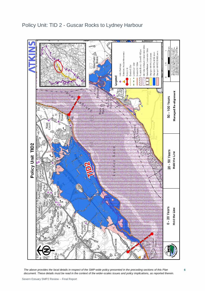
Policy Unit: TID 1 – The end of Beachley Road, Beachley Point to Guscar Rocks

The above provides the local details in respect of the SMP-wide policy presented in the preceding sections of this Plan document. These details must be read in the context of the wider-scales issues and policy implications, as reported therein.
Severn Estuary SMP2 Review – Final Report
4
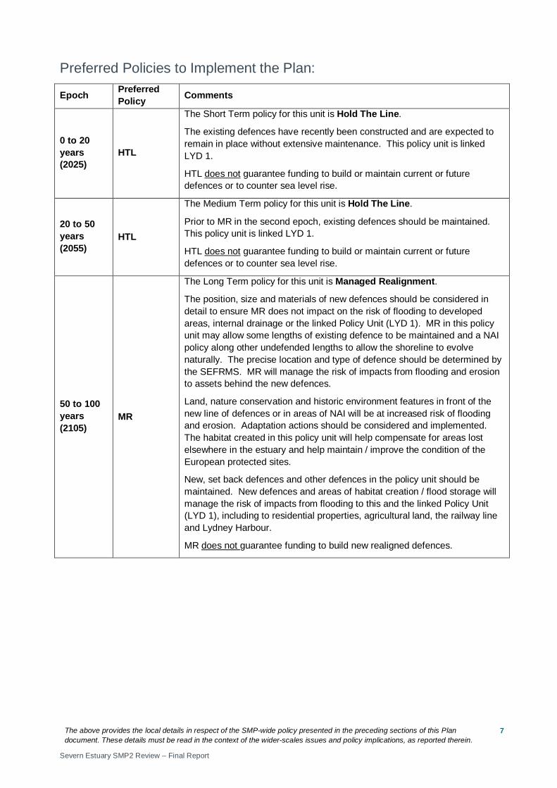
Preferred Policies to Implement the Plan:
Epoch Preferred Policy Comments
0 to 20 years (2025)
NAI
The Short Term policy for this unit is No Active Intervention.
The mudstone cliffs will undergo some limited erosion. High ground limits flood risk. Failed flap outfalls may lead to increased flood risk in very isolated areas, possibly impacting on the railway embankment and agricultural land – this should be monitored as sea level rises and action taken, if appropriate. Defences should be monitored to ensure they do not pose a risk to H&S under NAI.
This Policy Unit is not linked to any others.
20 to 50 years (2055)
NAI
The Medium Term policy for this unit is No Active Intervention.
Erosion will result in a slow realignment of the shoreline. High ground limits flood risk. Failed flap outfalls may lead to increased flood risk in very isolated areas, possibly impacting on the railway embankment and agricultural land – this should be monitored as sea level rises and action taken, if appropriate. Defences should be monitored to ensure they do not pose a risk to H&S under NAI.
This Policy Unit is not linked to any others.
50 to 100 years (2105)
NAI
The Long Term policy for this unit is No Active Intervention.
Increasing erosion will result in further realignment of the shoreline. High ground limits flood risk. Failed flap outfalls and sea level rise increases flood risk in isolated areas, possibly impacting on the railway embankment and agricultural land – this should be monitored as sea level rises and action taken, if appropriate. Defences should be monitored to ensure they do not pose a risk to H&S under NAI.
This Policy Unit is not linked to any others.
Economics
Policy Unit
Existing SMP1 Policy
Time Period (epoch) SMP2 Assessment
0-20
20-50
50-100
Preferred Plan Present Value Damages
Preferred Plan Present Value Defence Costs
TID 1 Do nothing NAI NAI NAI Minimal Minimal
The preferred policy has no economic impact in this Policy Unit. This Policy Unit is not linked to any others.
The above provides the local details in respect of the SMP-wide policy presented in the preceding sections of this Plan document. These details must be read in the context of the wider-scales issues and policy implications, as reported therein.
Severn Estuary SMP2 Review – Final Report
5
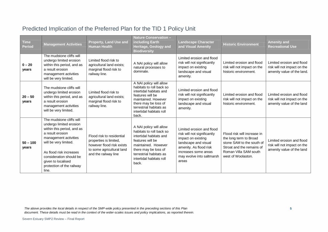
Predicted Implication of the Preferred Plan for the TID 1 Policy Unit
Time Period Management Activities Property, Land Use and
Human Health
Nature Conservation – including Earth Heritage, Geology and Biodiversity
Landscape Character and Visual Amenity Historic Environment Amenity and
Recreational Use
0 – 20 years
The mudstone cliffs will undergo limited erosion within this period, and as a result erosion management activities will be very limited.
Limited flood risk to agricultural land exists; marginal flood risk to railway line.
A NAI policy will allow natural processes to dominate.
Limited erosion and flood risk will not significantly impact on existing landscape and visual amenity.
Limited erosion and flood risk will not impact on the historic environment.
Limited erosion and flood risk will not impact on the amenity value of the land.
20 – 50 years
The mudstone cliffs will undergo limited erosion within this period, and as a result erosion management activities will be very limited.
Limited flood risk to agricultural land exists; marginal flood risk to railway line.
A NAI policy will allow habitats to roll back so intertidal habitats and features will be maintained. However there may be loss of terrestrial habitats as intertidal habitats roll back.
Limited erosion and flood risk will not significantly impact on existing landscape and visual amenity.
Limited erosion and flood risk will not impact on the historic environment.
Limited erosion and flood risk will not impact on the amenity value of the land
50 – 100 years
The mudstone cliffs will undergo limited erosion within this period, and as a result erosion management activities will be very limited.
As flood risk increases consideration should be given to localised protection of the railway line.
Flood risk to residential properties is limited, however flood risk exists to some agricultural land and the railway line
A NAI policy will allow habitats to roll back so intertidal habitats and features will be maintained. However there may be loss of terrestrial habitats as intertidal habitats roll back.
Limited erosion and flood risk will not significantly impact on existing landscape and visual amenity. As flood risk increases some areas may evolve into saltmarsh areas
Flood risk will increase in the long term to Broad stone SAM to the south of Stroat and the remains of Roman Villa SAM south west of Woolaston.
Limited erosion and flood risk will not impact on the amenity value of the land
The above provides the local details in respect of the SMP-wide policy presented in the preceding sections of this Plan document. These details must be read in the context of the wider-scales issues and policy implications, as reported therein.
Severn Estuary SMP2 Review – Final Report
6
Policy Unit: TID 2 - Guscar Rocks to Lydney Harbour
The above provides the local details in respect of the SMP-wide policy presented in the preceding sections of this Plan document. These details must be read in the context of the wider-scales issues and policy implications, as reported therein.
Severn Estuary SMP2 Review – Final Report
7
Preferred Policies to Implement the Plan:
Epoch Preferred Policy Comments
0 to 20 years (2025)
HTL
The Short Term policy for this unit is Hold The Line.
The existing defences have recently been constructed and are expected to remain in place without extensive maintenance. This policy unit is linked LYD 1.
HTL does not guarantee funding to build or maintain current or future defences or to counter sea level rise.
20 to 50 years (2055)
HTL
The Medium Term policy for this unit is Hold The Line.
Prior to MR in the second epoch, existing defences should be maintained. This policy unit is linked LYD 1.
HTL does not guarantee funding to build or maintain current or future defences or to counter sea level rise.
50 to 100 years (2105)
MR
The Long Term policy for this unit is Managed Realignment.
The position, size and materials of new defences should be considered in detail to ensure MR does not impact on the risk of flooding to developed areas, internal drainage or the linked Policy Unit (LYD 1). MR in this policy unit may allow some lengths of existing defence to be maintained and a NAI policy along other undefended lengths to allow the shoreline to evolve naturally. The precise location and type of defence should be determined by the SEFRMS. MR will manage the risk of impacts from flooding and erosion to assets behind the new defences.
Land, nature conservation and historic environment features in front of the new line of defences or in areas of NAI will be at increased risk of flooding and erosion. Adaptation actions should be considered and implemented. The habitat created in this policy unit will help compensate for areas lost elsewhere in the estuary and help maintain / improve the condition of the European protected sites.
New, set back defences and other defences in the policy unit should be maintained. New defences and areas of habitat creation / flood storage will manage the risk of impacts from flooding to this and the linked Policy Unit (LYD 1), including to residential properties, agricultural land, the railway line and Lydney Harbour.
MR does not guarantee funding to build new realigned defences.

The above provides the local details in respect of the SMP-wide policy presented in the preceding sections of this Plan document. These details must be read in the context of the wider-scales issues and policy implications, as reported therein.
Severn Estuary SMP2 Review – Final Report
8
Economics
Policy Unit
Existing SMP1 Policy
Time Period (epoch) SMP2 Assessment
0-20
20-50
50-100
Preferred Plan Present Value Damages
Preferred Plan Present Value Defence Costs
TID 2 HTL HTL HTL MR £0m (TID2, LYD1 total)
£8m (TID2, LYD1 total)
The preferred policy is economically viable for the linked Policy Units of TID 2, and LYD 1. The costs and damages of the preferred policy in the table above relate to actions taken in all linked policy units.

The above provides the local details in respect of the SMP-wide policy presented in the preceding sections of this Plan document. These details must be read in the context of the wider-scales issues and policy implications, as reported therein.
Severn Estuary SMP2 Review – Final Report
9
Predicted Implication of the Preferred Plan for the TID 2 Policy Unit
Time Period Management Activities Property, Land Use and
Human Health
Nature Conservation – including Earth Heritage, Geology and Biodiversity
Landscape Character and Visual Amenity Historic Environment Amenity and
Recreational Use
0 – 20 years
The existing defences have recently been constructed and are expected to remain in place without extensive maintenance. Defences should be monitored and maintained
Flood risk to residential properties is limited; however there is some flood risk to some agricultural land and the railway line.
There will be limited impact in this epoch as the existing defence line will continue to protect the area from flood and erosion risk. Works should take account of possible environmental impacts and the need for an EIA.
Limited erosion and flood risk will not impact on existing landscape and visual amenity.
Limited erosion and flood risk to historical assets.
Limited erosion and flood risk will not impact on the amenity value of the land or recreational use of the harbour in the adjacent unit.
20 – 50 years
Existing defences should be monitored and maintained. Detailed investigation on the position, size, type and construction of new defences should begin.
Flood risk to residential properties is limited; however there is some flood risk to some agricultural land and the railway line.
There will be limited impact in this epoch as the existing defence line will continue to protect the area from flood and erosion risk. Works should take account of possible environmental impacts and the need for an EIA.
Limited erosion and flood risk will not impact on existing landscape and visual amenity.
Limited erosion and flood risk to historical assets.
Limited erosion and flood risk will not impact on the amenity value of the land or recreational use of the harbour in the adjacent unit.
50 – 100 years
Realigned defences should be established (subject to further studies) to determine the location and type of defence. The new defence line should be monitored and maintained.
Realigned defences will protect property and land behind new defences. Assets in front of realigned defences will be at risk from inundation. Impacts to property and land and mitigation actions will need to be considered in determining realignment of defences.
National and internationally designated nature conservation sites will benefit from the natural evolution of the shoreline in front of the realigned defence line. However there may be loss of terrestrial habitats. Works should take account of possible environmental impacts and the need for an EIA.
The area to the front of the new defence line will be subject to more frequent flooding, potentially with the development of mud/salt marsh areas
Realigned defences will protect historic environment behind new defences. Historic assets in front of realigned defences will be at risk from inundation. Impacts on historic environment and mitigation actions will need to be considered in determining realignment of defences.
Limited erosion and flood risk will not impact on the amenity value of the land or recreational use of the harbour in the adjacent unit.