SMM Daily Report 2021-10-11
15
- 1 - 1 Summary In Donetsk region, between the evenings of 8 and 10 October, the Mission recorded 150 ceasefire violations, including 35 explosions. In the previous reporting period, it recorded 47 ceasefire violations in the region. In Luhansk region, between the evenings of 8 and 10 October, the SMM recorded 120 ceasefire violations, including 49 explosions. In the previous reporting period, it recorded two ceasefire violations in the region. The Mission corroborated a civilian casualty in non-government-controlled Sentianivka, Luhansk region. The Mission continued monitoring the disengagement areas near Stanytsia Luhanska, Zolote and Petrivske. It recorded ceasefire violations inside the disengagement areas near Zolote and Petrivske. The SMM facilitated and monitored adherence to localized ceasefires to enable the operation and repairs of critical civilian infrastructure. The Mission continued following up on the situation of civilians, including at five entry-exit checkpoints and four corresponding checkpoints of the armed formations in Donetsk and Luhansk regions. The SMM visited two border crossing points outside government control and monitored areas close to the border with the Russian Federation in Donetsk region. The Mission monitored the security situation in east and south-east Kherson region. The Mission’s freedom of movement continued to be restricted, including at a checkpoint of the armed formations in Zhabunki, Donetsk region. Its unmanned aerial vehicles again experienced multiple instances of jamming.* 1 Based on information from the Monitoring Teams as of 19:30, 10 October 2021. All times are in Eastern European Summer Time. Daily Report 238/2021 11 October 2021 1
Transcript of SMM Daily Report 2021-10-11

- 1 -
1
Summary
In Donetsk region, between the evenings of 8 and 10 October, the Mission recorded 150 ceasefire violations, including 35 explosions. In the previous reporting period, it recorded 47 ceasefire violations in the region.
In Luhansk region, between the evenings of 8 and 10 October, the SMM recorded 120 ceasefire violations, including 49 explosions. In the previous reporting period, it recorded two ceasefire violations in the region.
The Mission corroborated a civilian casualty in non-government-controlled Sentianivka, Luhansk region.
The Mission continued monitoring the disengagement areas near Stanytsia Luhanska, Zolote and Petrivske. It recorded ceasefire violations inside the disengagement areas near Zolote and Petrivske.
The SMM facilitated and monitored adherence to localized ceasefires to enable the operation and repairs of critical civilian infrastructure.
The Mission continued following up on the situation of civilians, including at five entry-exit checkpoints and four corresponding checkpoints of the armed formations in Donetsk and Luhansk regions.
The SMM visited two border crossing points outside government control and monitored areas close to the border with the Russian Federation in Donetsk region.
The Mission monitored the security situation in east and south-east Kherson region. The Mission’s freedom of movement continued to be restricted, including at a checkpoint of
the armed formations in Zhabunki, Donetsk region. Its unmanned aerial vehicles again experienced multiple instances of jamming.*
1 Based on information from the Monitoring Teams as of 19:30, 10 October 2021. All times are in Eastern
European Summer Time.
Daily Report 238/2021 11 October 20211

- 2 -
Ceasefire violations2 Number of recorded ceasefire violations3 Number of recorded explosions4
2 For a complete breakdown of ceasefire violations, please see the annexed table. During the reporting period, the
SMM camera at the Oktiabr mine was not operational. 3 Including explosions. 4 Including from unidentified weapons.

- 3 -
Map of recorded ceasefire violations

- 4 -
In Donetsk region, between the evenings of 8 and 10 October, the SMM recorded 150 ceasefire violations, including 35 explosions (one impact, two airbursts and 32 undetermined). The majority of ceasefire violations occurred in areas close to the disengagement area near Petrivske (non-government-controlled, 41km south of Donetsk), including 33 shots of small-arms fire assessed as a live-fire exercise in violation of the decision of the Trilateral Contact Group (TCG) of 3 March 2016 that prohibits the conduct of live-fire training in the security zone (see below), as well as north of the entry-exit checkpoint in Marinka (government-controlled, 23km south-west of Donetsk) and north of Shyrokyne (government-controlled, 100km south of Donetsk). In the previous reporting period, the Mission recorded 47 ceasefire violations in the region. In Luhansk region, between the evenings of 8 and 10 October, the Mission recorded 120 ceasefire violations, including 49 explosions (one airburst and 48 undetermined). All these ceasefire violations occurred inside or near the disengagement area near Zolote (government-controlled, 60km west of Luhansk), with the majority occurring on the evening of 9 October (see below). In the previous reporting period, the SMM recorded two ceasefire violations in the region, also close to the aforementioned area. Following agreement reached at the meeting of the TCG on 22 July 2020 regarding Measures to strengthen the ceasefire, from 00:01 on 27 July 2020 until the end of the reporting period, the Mission has recorded at least 63,181 ceasefire violations in both Donetsk and Luhansk regions (including 17,302 explosions, 12,601 projectiles in flight, 280 muzzle flashes, 254 illumination flares and at least 32,744 bursts and shots). Civilian casualty corroborated in non-government-controlled Sentianivka, Luhansk region The Mission followed up on reports of a man injured on 7 September in Sentianivka (formerly Frunze, non-government-controlled, 44km west of Luhansk). On 8 October, a man (in his fifties) told the SMM over the phone that on the evening of 7 September, while in the garden of his parents’ house on Pershoho Travnia Street in Sentianivka, he had heard a loud sound and then lost consciousness. He said that when he had regained consciousness, he saw blood near his body and called a friend for help. He told the Mission that an ambulance had later brought him to a hospital in Holubivka (formerly Kirovsk, non-government-controlled, 51km west of Luhansk). On the same day, a man (age unknown), told the SMM over the phone that on 7 September, he received a call from his friend in Sentianivka, and that he then called an ambulance and walked to Sentianivka, where he saw that his friend was injured. On 14 September, medical staff at a hospital in Holubivka confirmed to the SMM that on the evening of 7 September, a man (in his fifties) had been admitted to the hospital with multiple shrapnel injuries.

- 5 -
Disengagement areas near Stanytsia Luhanska, Zolote and Petrivske5 On 9 October, inside the disengagement area near Stanytsia Luhanska (government-controlled, 16km north-east of Luhansk), the Mission saw members of the armed formations (wearing armbands with “JCCC” written on them) south of the repaired span of the Stanytsia Luhanska bridge (15km north-east of Luhansk). On the evening of 8 October, the SMM camera in Popasna (government-controlled 69km west of Luhansk) recorded one explosion (airburst) at an assessed range of 3-5km east-south-east. On the same evening, the SMM camera in Zolote recorded one illumination flare at an assessed range of 5-7km south-east. These ceasefire violations were assessed as outside the disengagement area near Zolote (government-controlled, 60km west of Luhansk) but within 5km of its periphery. During the day on 9 October, while positioned on the southern edge of the disengagement area near Zolote, the Mission heard two bursts of small-arms fire at an assessed range of 300-500m north-north-west, assessed as inside the area, as well as one undetermined explosion at an assessed range of 2-3km north-north-east, unable to be assessed as either inside or outside the area, and 20 undetermined explosions at an assessed range of 3-5km north-north-east, assessed as outside the area but within 5km of its periphery. During the evening of 9 October, the SMM camera in Popasna, recorded two projectiles in flight at an assessed range 3-5km east-south-east. On the same evening, while on the northern edge of Popasna, the Mission heard four undetermined explosions at an assessed range of 6-8km east-south-east. These ceasefire violations were assessed as outside the disengagement area but within 5km of its periphery. During the day on 10 October, while positioned on the southern and eastern edges of the disengagement area, the SMM heard one explosion at an assessed range of 4-5km north-east and seven bursts of heavy-machine-gun fire at an assessed range of 1-2km north, all assessed as outside the disengagement area but within 5km of its periphery. On 9 and 10 October, near the checkpoint of the armed formations south of the disengagement area near Zolote, the Mission saw members of the armed formations (wearing armbands with “JCCC” written on them). On both days, the SMM again saw the seven previously observed containers located south of the disengagement area’s southern edge and inside the area, as well as the previously reported underground structure inside the area. On the night of 8-9 October, the SMM camera 2km east of Bohdanivka (government-controlled, 41km south-west of Donetsk) recorded five projectiles in flight at an assessed range of 2-3km east-south-east, assessed as inside the disengagement area near Petrivske (non-government-controlled, 41km south of Donetsk). During the day on 9 October, while positioned about 2km north of Petrivske, the Mission heard one undetermined explosion at an assessed range of 5-7km west, assessed as outside the disengagement area but within 5km of its periphery.
5 Disengagement is foreseen in the Framework Decision of the Trilateral Contact Group relating to disengagement
of forces and hardware of 21 September 2016.

- 6 -
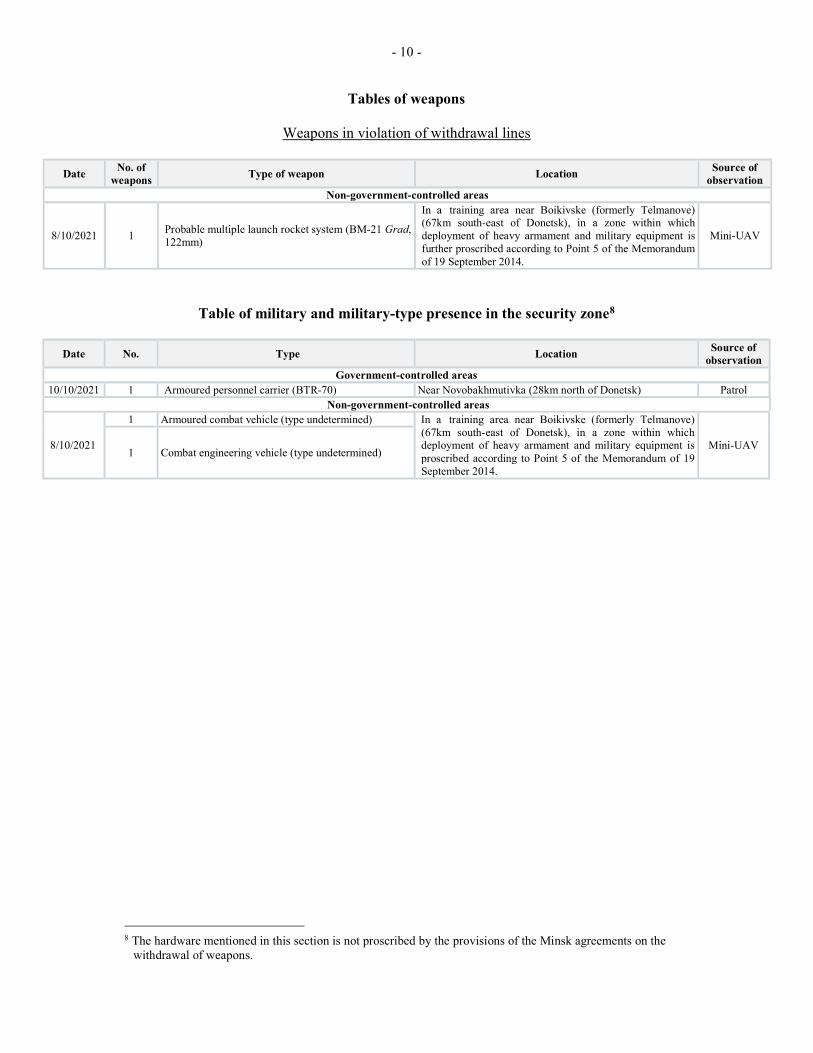
On the evening of 9 October, the SMM camera 2km east of Bohdanivka recorded two projectiles in flight at an assessed range of 2-3km east-south-east, assessed as inside the disengagement area, as well as six projectiles in flight at an assessed range of 4-6km east-south-east, unable to be assessed as either inside or outside the area. During the day on 10 October, while positioned about 2km east of Bohdanivka, the Mission heard 33 shots of small-arms fire at an assessed distance of 1.5km west, assessed as a live-fire exercise, all assessed as outside the disengagement area but within 5km of its periphery. (For previous observations of live-fire exercises near the disengagement area, please see SMM Daily Report 6 October 2021.) On the same day, while positioned about 2km north of Petrivske, the SMM heard 15 undetermined explosions at an assessed range of 3-4km south-south-east, assessed as outside the disengagement are but within 5km of its periphery. Withdrawal of weapons The SMM continued to monitor the withdrawal of weapons in implementation of the Memorandum and the Package of Measures and its Addendum. In violation of withdrawal lines, the Mission observed one probable multiple launch rocket system in a training area near Boikivske (formerly Telmanove) (67km south-east of Donetsk) in a non-government-controlled area of Donetsk region, in a zone within which deployment of heavy armaments and military equipment is further proscribed according to Point 5 of the Memorandum of 19 September 2014. (For further information, see the table below.) Indications of military and military-type presence in the security zone In Donetsk region, the Mission observed an armoured personnel carrier in a government-controlled area and an armoured combat vehicle and combat engineering vehicle in the abovementioned training area in a non-government-controlled area, in a zone within which deployment of military equipment is proscribed according to Point 5 of the Memorandum of 19 September 2014. (For further information, see the table below.) Mine hazard sign in government-controlled Luhanske, Donetsk region On 10 October, on the south-western edge of Luhanske (government-controlled, 59km north-east of Donetsk), south of Stepna Street, the SMM observed a mine hazard sign (a yellow rectangular board with a skull and crossbones on a red square and “Attention! Access to this territory is dangerous!” written in Ukrainian, not previously reported). SMM facilitation - the operation and repairs of critical civilian infrastructure On 9 and 10 October, the Mission continued to facilitate the operation of the Donetsk Filtration Station (15km north of Donetsk). On 10 October, the SMM also monitored adherence to a localized ceasefire to enable repairs to a power substation in Pikuzy (formerly Kominternove, non-government-controlled, 92km south of Donetsk).

- 7 -
Situation at entry-exit checkpoints and corresponding checkpoints On 9 October, in Donetsk region, the SMM saw that the entry-exit checkpoint (EECP) near Maiorsk (government-controlled, 45km north-east of Donetsk) was open, but did not observe any traffic passing through. On the same day it noted that the checkpoint of the armed formations near Olenivka (non-government-controlled, 23km south-west of Donetsk) was closed. On 10 October, the Mission saw that the EECP near Marinka (government-controlled, 23km south-west of Donetsk) was open, but did not observed any traffic passing through. On the same day it noted that the corresponding checkpoint of the armed formations near Kreminets (non-government-controlled, 16km south-west of Donetsk) was closed. On 9 and 10 October, in Luhansk region, the Mission observed that the EECP near Stanytsia Luhanska was open, with people queueing to travel in both directions. On 9 October, it also observed that the corresponding checkpoint of the armed formations south of the Stanytsia Luhanska bridge was open, with people queueing to travel in both directions. On 10 October, the SMM saw a large number of people standing on the Stanytsia Luhanska bridge, before the checkpoint of the armed formations. On 9 and 10 October, the SMM noted that the EECPs near Zolote and Shchastia (government-controlled, 20km north of Luhansk) were open, but that the corresponding checkpoints of the armed formations south of the disengagement area near Zolote and 3km south-east of the bridge in Shchastia were closed. Border areas outside government control On 9 October, while at a border crossing point near Uspenka (73km south-east of Donetsk), for about 60 minutes, the Mission observed 23 cars (including 13 with “DPR” plates) and 51 pedestrians (26 women, 21 men and four children, mixed ages) entering Ukraine. During the same time, the SMM observed 19 cars (including 11 with “DPR” plates), ten covered cargo trucks (including seven with “DPR” plates), a bus (with “DPR” plates, carrying ten people of mixed genders and ages) as well as 36 pedestrians (21 women, 14 men and one child, mixed ages) exiting Ukraine.6 On the same day, the SMM also monitored areas near the border with the Russian Federation close to Manych (76km east of Donetsk) and observed no change in the security situation. On 10 October, while at border crossing point near Uspenka for about 65 minutes, the Mission observed ten cars (all with “DPR” plates), 36 covered cargo trucks (including 20 with “DPR” plates) and 30 people (16 women and 14 men, mixed ages) entering Ukraine. During the same time, the SMM observed six cars (including four with “DPR” plates), one covered cargo truck (with “DPR” plates) and eight people (two women and six men, mixed ages) exiting Ukraine. On the same day, while at a border crossing point near Ulianivske (61km south-east of Donetsk) for about 40 minutes, the SMM observed six people (three women and three men,
6 According to decisions in 2014 by the Cabinet of Ministers of Ukraine, operations are officially designated as
suspended at these and other border crossing points located outside government control.

- 8 -
mixed ages) entering Ukraine and 13 people (mixed genders and ages, including two children) exiting Ukraine. On the same day, the SMM also monitored areas near the border with the Russian Federation close to Pobeda (57km south-east of Donetsk) and observed no change in the security situation. Security situation in east and south-east Kherson region From 7 to 9 October, the SMM monitored areas in east and south-east Kherson region at checkpoints near Kalanchak (67km south-east of Kherson), Chaplynka (77km south-east of Kherson) and Chonhar (163km south-east of Kherson) and along the Sea of Azov near Henichesk (176km east of Kherson), Stokopani (181km east of Kherson) and Strilkove (193km south-east of Kherson). While monitoring these areas, the Mission observed no change in the security situation. The SMM continued monitoring in Odessa, Lviv, Ivano-Frankivsk, Kharkiv, Dnipro, Chernivtsi, and Kyiv. *Restrictions of the SMM’s freedom of movement or other impediments to fulfilment of its mandate The SMM’s monitoring and freedom of movement are restricted by security hazards and threats, including risks posed by mines, UXO and other impediments – which vary from day to day. The SMM’s mandate provides for safe and secure access throughout Ukraine. All signatories of the Minsk agreements have agreed on the need for this safe and secure access, that restriction of the SMM’s freedom of movement constitutes a violation, and on the need for rapid response to these violations. They have also agreed that the Joint Centre for Control and Co-ordination (JCCC) should contribute to such response and co-ordinate mine clearance. Nonetheless, the armed formations in parts of Donetsk and Luhansk regions frequently deny the SMM access to areas adjacent to Ukraine’s border outside control of the government (for example, see SMM Daily Report of 9 October 2021). The SMM’s operations in Donetsk and Luhansk regions remain restricted following the fatal incident of 23 April 2017 near Pryshyb; these restrictions continued to limit the Mission’s observations. Regular restrictions related to disengagement areas and mines/UXO: - The sides continued to deny the SMM full access, as well as the ability to travel certain roads
previously identified as important for effective monitoring by the Mission and for civilians’ movement, through failure to conduct comprehensive clearance of mines, UXO and other obstacles.
Delay: - At a checkpoint on the north-eastern edge of Zhabunki (non-government-controlled, 9km
north-west of Donetsk), a visibly armed member of the armed formations allowed the Mission passage south-west towards Oktiabr mine only after about 18 minutes of waiting, referring to a lack of prior notification.
Other impediments:7
7 For cases of probable jamming and jamming mentioned in this section, the interference could have originated
from anywhere within the radius of tens of kilometres from the UAVs’ positions.

- 9 -
- On 9 October, while conducting a test flight, an SMM long-range unmanned aerial vehicle
(UAV) experienced GPS signal interference, assessed as caused by probable jamming, while flying over areas between Sofiivka (formerly Artemivka, government-controlled, 63km north-west of Donetsk) and Slavne (government-controlled, 26km south-west of Donetsk) and between Kalynove (government-controlled, 31km north-west of Donetsk) and Varvarivka (government-controlled, 81km north-west of Donetsk). The same UAV experienced dual GPS signal interference, assessed as caused by jamming, while flying over areas between Slavne and Kalynove.
- On 10 October, while conducting a test flight, an SMM long-range UAV experienced GPS signal interference, assessed as caused by probable jamming, while flying over areas between Novoandriivka (government-controlled, 75km north-west of Donetsk) and Andriivka (government-controlled, 57km north of Donetsk) and over areas near Varvarivka (government-controlled, 81km north-west of Donetsk). The same UAV experienced dual GPS signal interference, assessed as caused by jamming, while flying over areas between Andriivka and Varvarivka.
- On the same day, SMM mini-UAVs experienced GPS signal interference, assessed as caused by probable jamming, during 18 flights: once while flying on the southern edge of the disengagement area near Zolote, and over areas near Khoroshe (non-government-controlled, 36km west of Luhansk), Vuhlehirsk (non-government-controlled, 49km north-east of Donetsk), Debaltsivske (formerly Komuna, non-government-controlled, 56km north-east of Donetsk), twice over areas near Lohvynove (non-government-controlled, 59km north-east of Donetsk), three times over areas near Nyzhnie Lozove (non-government-controlled, 59km north-east of Donetsk), four times over areas near Lozove (non-government-controlled, 52km north-east of Donetsk) and five times over areas near Luhanske (government-controlled, 59km north-east of Donetsk).
- Also on the same day, the Mission cancelled five mid-range UAV flights due to GPS signal interference, assessed as caused by probable jamming, twice each near Vuhlehirsk and Lohvynove and once near Luhanske.
- 10 -
Tables of weapons
Weapons in violation of withdrawal lines
Table of military and military-type presence in the security zone8
Date No. Type Location Source of
observation Government-controlled areas
10/10/2021 1 Armoured personnel carrier (BTR-70) Near Novobakhmutivka (28km north of Donetsk) Patrol Non-government-controlled areas
8/10/2021
1 Armoured combat vehicle (type undetermined) In a training area near Boikivske (formerly Telmanove) (67km south-east of Donetsk), in a zone within which deployment of heavy armament and military equipment is proscribed according to Point 5 of the Memorandum of 19 September 2014.
Mini-UAV 1 Combat engineering vehicle (type undetermined)
8 The hardware mentioned in this section is not proscribed by the provisions of the Minsk agreements on the
withdrawal of weapons.
Date No. of
weapons Type of weapon Location
Source of observation
Non-government-controlled areas
8/10/2021 1 Probable multiple launch rocket system (BM-21 Grad, 122mm)
In a training area near Boikivske (formerly Telmanove) (67km south-east of Donetsk), in a zone within which deployment of heavy armament and military equipment is further proscribed according to Point 5 of the Memorandum of 19 September 2014.
Mini-UAV

- 11 -
Table of ceasefire violations as of 10 October 20219
SMM position Event location Means No. Observation Description Weapon Date, time
SMM camera 2km E of Bohdanivka (government-controlled, 41km SW of Donetsk)
2-3km ESE Recorded 5 Projectile
N to S (assessed as inside the disengagement area near Petrivske)
N/K 9-Oct, 03:18
SMM camera 1.5km NE of Hnutove (government-controlled, 90km S of Donetsk)
3-5km SE Recorded 2 Muzzle flash N/K 8-Oct, 22:03
SMM camera 1km SW of Shyrokyne (government-controlled, 100km S of Donetsk)
2-4km NNE Recorded 1 Explosion Undetermined N/K 8-Oct, 23:16
5-7km N Recorded 1 Explosion Undetermined N/K 8-Oct, 23:36
5-7km N Recorded 1 Projectile E to W N/K 9-Oct, 00:16
5-7km N Recorded 3 Projectile E to W N/K 9-Oct, 01:21
5-7km N Recorded 1 Projectile E to W N/K 9-Oct, 01:22
5-7km N Recorded 2 Projectile E to W N/K 9-Oct, 02:50
5-7km N Recorded 1 Illumination flare
In vertical flight N/K 9-Oct, 02:51
4-6km N Recorded 1 Muzzle flash N/K 9-Oct, 18:45
4-6km N Recorded 1 Projectile NW to SE (subsequent to previous event)
N/K 9-Oct, 18:45
4-5km N Recorded 1 Explosion Airburst (subsequent to previous event)
N/K 9-Oct, 18:45
4-6km N Recorded 1 Explosion Undetermined N/K 9-Oct, 18:50
4-6km N Recorded 1 Explosion Undetermined N/K 9-Oct, 18:57
About 2km N of Petrivske (non-government-controlled, 41km S of Donetsk)
5-7km W Heard 1 Explosion
Undetermined (assessed as outside the disengagement area)
N/K 9-Oct, 13:25
SMM camera on N edge of Popasna (government-controlled, 69km W of Luhansk)
2-4km ESE Recorded 1 Projectile N to S N/K 8-Oct, 19:35
3-5km E Recorded 1 Projectile NNE to SSW N/K 8-Oct, 22:49
3-5km ESE Recorded 1 Explosion
Airburst (subsequent to previous event and assessed as outside the disengagement area near Zolote)
N/K 8-Oct, 22:49
SMM camera in Zolote (government-controlled, 60km W of Luhansk)
5-7km SE Recorded 1 Illumination flare
In vertical flight (assessed as outside the disengagement area, also recorded by the SMM camera in Popasna)
N/K 8-Oct, 22:20
About 3km N of Pervomaisk (non-government controlled, 58km W of Luhansk)
300-500m NNW
Heard 2 Burst
Undetermined (assessed as inside the disengagement area near Zolote)
Small arms 9-Oct, 10:03-10:06
2-3km NNE Heard 1 Explosion
Undetermined (unable to be assessed as either inside or outside
N/K 9-Oct, 10:09
9 The table only includes ceasefire violations directly observed by SMM patrols or recorded by the SMM cameras,
and it may include those also assessed to be live-fire exercises, controlled detonations, etc. Details provided – in terms of distance, direction, weapons-type, etc. – are based on assessments provided by monitors on the ground and technical monitoring officers, and are not always necessarily precise. When information is not known (indicated with an “N/K”), the SMM was unable to ascertain such information due to distance, weather conditions technical limitations and/or other considerations. Ceasefire violations recorded by more than one patrol/camera and assessed to be the same are entered only once.

- 12 -
SMM position Event location Means No. Observation Description Weapon Date, time
the disengagement area near Zolote)
3-5km NNE Heard 20 Explosion
Undetermined (assessed as outside the disengagement area near Zolote)
N/K 9-Oct, 13:42-13:52
SMM camera 2km E of Bohdanivka (government-controlled, 41km SW of Donetsk)
4-6km ESE Recorded 1 Projectile
NW to SE (unable to be assessed as either inside or outside the disengagement area near Petrivske)
N/K 9-Oct, 20:27
4-6km ESE Recorded 1 Projectile
SW to NE (unable to be assessed as either inside or outside the disengagement area near Petrivske)
N/K 9-Oct, 20:27
2-3km ESE Recorded 2 Projectile
SSW to NNE (assessed as inside the disengagement area near Petrivske)
N/K 9-Oct, 20:59
4-6km ESE Recorded 1 Projectile
NNW to SSE (unable to be assessed as either inside or outside the disengagement area near Petrivske)
N/K 9-Oct, 21:31
4-6km ESE Recorded 1 Projectile
In vertical flight (unable to be assessed as either inside or outside the disengagement area near Petrivske)
N/K 9-Oct, 23:07
4-6km ESE Recorded 1 Projectile
N to S (unable to be assessed as either inside or outside the disengagement area near Petrivske)
N/K 9-Oct, 23:20
4-6km ESE Recorded 1 Projectile
N to S (unable to be assessed as either inside or outside the disengagement area near Petrivske)
N/K 9-Oct, 23:21
SMM camera in Chermalyk (government-controlled, 77km S of Donetsk)
3-5km SE Recorded 3 Projectile N to S N/K 9-Oct, 18:55
SMM camera at EECP in Marinka (government-controlled, 23km SW of Donetsk)
2-4km NNE Recorded 1 Explosion Undetermined N/K 9-Oct, 20:27
2-4km NNE Recorded 29 Projectile SE to NW N/K 9-Oct, 20:27
2-4km NNE Recorded 1 Projectile SE to NW N/K 9-Oct, 20:27
2-4km NNE Recorded 1 Explosion Airburst (subsequent to previous event)
N/K 9-Oct, 20:27
2-4km NNE Recorded 1 Explosion Undetermined N/K 9-Oct, 20:28
2-4km NNE Recorded 1 Projectile SE to NW N/K 9-Oct, 20:28
2-4km NNE Recorded 3 Projectile SW to NE N/K 10-Oct, 02:17
2-4km NNE Recorded 3 Projectile SW to NE N/K 10-Oct, 02:18
2-4km N Recorded 1 Projectile WSW to ENE N/K 10-Oct, 18:53

- 13 -
SMM position Event location Means No. Observation Description Weapon Date, time
SMM camera 1km SW of Shyrokyne (government-controlled, 100km S of Donetsk)
5-7km N Recorded 1 Projectile W to E N/K 9-Oct, 19:46
3-5km NNE Recorded 2 Projectile SW to NE N/K 9-Oct, 20:09
3-5km NNE Recorded 3 Projectile SW to NE N/K 9-Oct, 20:12
5-7km NE Recorded 1 Explosion Undetermined N/K 9-Oct, 20:12
3-5km NNE Recorded 2 Projectile SW to NE N/K 9-Oct, 20:13
4-6km N Recorded 1 Explosion Undetermined N/K 9-Oct, 20:13
3-5km NNE Recorded 2 Projectile SW to NE N/K 9-Oct, 20:23
3-5km N Recorded 2 Projectile SW to NE N/K 9-Oct, 20:24
3-5km N Recorded 2 Projectile SW to NE N/K 9-Oct, 20:25
3-5km N Recorded 1 Projectile SW to NE N/K 9-Oct, 20:25
3-5km N Recorded 1 Explosion Impact (subsequent to previous event)
N/K 9-Oct, 20:25
5-7km NNE Recorded 1 Projectile SSW to NNE N/K 9-Oct, 22:09
5-7km N Recorded 1 Illumination flare
E to W N/K 9-Oct, 23:57
5-7km N Recorded 1 Illumination flare
In vertical flight N/K 9-Oct, 23:58
5-7km N Recorded 1 Illumination flare
E to W N/K 10-Oct, 03:35
6-8km N Recorded 1 Illumination flare
In vertical flight N/K 10-Oct, 04:40
About 2km E of Bohdanivka (government-controlled, 41km SW of Donetsk)
1.5km W Heard 11 Shot
Assessed as outside the disengagement area near Petrivske.
Small arms 10-Oct, 10:10-10:20
1.5km W Heard 22 Shot
Assessed as outside the disengagement area near Petrivske.
Small arms 10-Oct, 10:25-10:45
About 2.1km WNW of Pisky (government-controlled, 12km NW of Donetsk)
2-3km E Heard 2 Explosion Undetermined N/K 10-Oct, 10:10
2-3km E Heard 2 Explosion Undetermined N/K 10-Oct, 11:05
2-3km E Heard 2 Explosion Undetermined N/K 10-Oct, 12:10
About 300m NE of Zhabunki (non-government-controlled, 9km NW of Donetsk)
1.5-2km NNE Heard 1 Explosion Undetermined N/K 10-Oct, 11:24
1km NNE Heard 1 Explosion Undetermined N/K 10-Oct, 11:30
About 2km N of Petrivske (non-government-controlled, 41km S of Donetsk)
3-4km SSE Heard 12 Explosion
Undetermined (assessed as outside the disengagement area)
N/K 10-Oct, 12:25
3-4km SSE Heard 3 Explosion
Undetermined (assessed as outside the disengagement area)
N/K 10-Oct, 12:36
SMM camera on N edge of Popasna (government-controlled, 69km W of Luhansk)
3-5km ESE Recorded 2 Projectile
N to S (assessed as outside the disengagement area near Zolote)
N/K 9-Oct, 20:56
N edge of Popasna (government-controlled, 69km W of Luhansk)
4-7km SE Heard 3 Explosion Undetermined N/K 9-Oct, 20:02-20:15
4-6km SE Heard 7 Explosion Undetermined N/K 9-Oct, 20:56-21:03
4-6km SE Heard 28 Burst HMG 9-Oct, 20:56-21:03
4-6km SE Heard 5 Explosion Undetermined N/K 9-Oct, 20:56-21:03
4-6km SE Heard 26 Burst
HMG 9-Oct, 20:56-21:03
6-8km ESE Heard 2 Explosion Undetermined (assessed as outside the
N/K 9-Oct, 23:04

- 14 -
SMM position Event location Means No. Observation Description Weapon Date, time
disengagement area near Zolote)
4-6km SE Heard 7 Explosion Undetermined N/K 9-Oct, 23:12-23:19
3-4km SE Heard 4 Burst Small arms 9-Oct, 23:24
6-8km ESE Heard 2 Explosion
Undetermined (assessed as outside the disengagement area near Zolote)
N/K 9-Oct, 23:31
About 3km N of Pervomaisk (non-government controlled, 58km W of Luhansk)
4-5km NE Heard 1 Explosion
Undetermined (assessed as outside the disengagement area near Zolote)
N/K 10-Oct, 10:30
Zolote 5/Mykhailivka (non-government-controlled, 60km west of Luhansk)
1-2km N Heard 7 Burst
Outgoing (assessed as outside the disengagement area)
HMG 10-Oct, 13:52-13:54
- 15 -
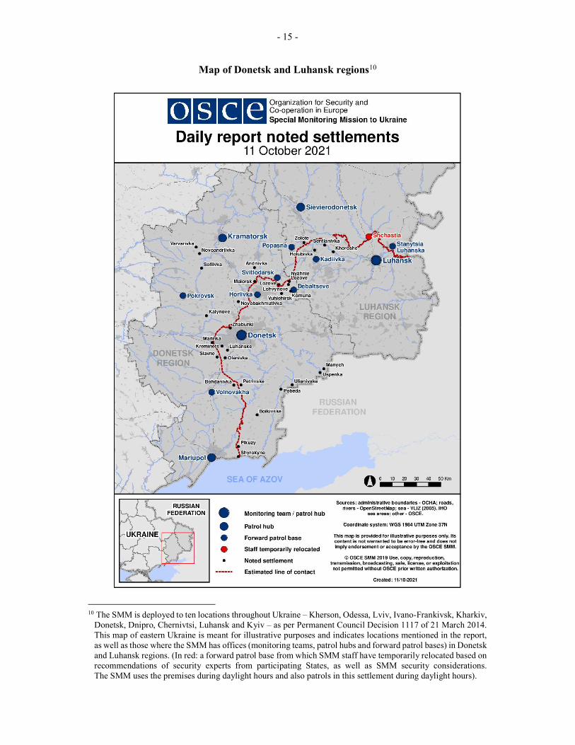
Map of Donetsk and Luhansk regions10
10 The SMM is deployed to ten locations throughout Ukraine – Kherson, Odessa, Lviv, Ivano-Frankivsk, Kharkiv,
Donetsk, Dnipro, Chernivtsi, Luhansk and Kyiv – as per Permanent Council Decision 1117 of 21 March 2014. This map of eastern Ukraine is meant for illustrative purposes and indicates locations mentioned in the report, as well as those where the SMM has offices (monitoring teams, patrol hubs and forward patrol bases) in Donetsk and Luhansk regions. (In red: a forward patrol base from which SMM staff have temporarily relocated based on recommendations of security experts from participating States, as well as SMM security considerations. The SMM uses the premises during daylight hours and also patrols in this settlement during daylight hours).