Smart Flashlight: Map Navigation Using a Bike...
4
Smart Flashlight: Map Navigation Using a Bike-mounted Projector Alexandru Dancu t2i lab, Chalmers [email protected] Zlatko Franjcic Qualisys AB and Chalmers [email protected] Morten Fjeld t2i lab, Chalmers [email protected] ABSTRACT While mobile phones affect our behavior and tend to separate us from our physical environment, our environment could in- stead become a responsive part of the information domain. For navigation using a map while cycling in an urban envi- ronment, we studied two alternative solutions: smartphone display and projection on the road. This paper firstly demon- strates by proof-of-concept a GPS-based map navigation us- ing a bike-mounted projector. Secondly, it implements a pro- totype using both a projector and a smartphone mounted on a bike, comparing them for use in a navigation system for nighttime cycling. Thirdly, it examines how visuo-spatial fac- tors influence navigation. Our findings will be useful for de- signing navigation systems for bikes and even for cars, help- ing cyclists and drivers be more attentive to their environment while navigating, providing useful information while moving. Author Keywords Bike; GPS; Navigation; Smartphone; Pico-projector; Visuo-spatial; Field of View ACM Classification Keywords H.5.m. Information Interfaces and Presentation (e.g. HCI): Miscellaneous INTRODUCTION Most mobile device interfaces today use a “stop-to-interact” paradigm [4]. This enables design for general-purpose in- teraction but makes several assumptions about the mode of operation, such as using both hands and holding the display still. This poses a challenge when designing interfaces for in- teraction in motion. This paper examines the design and use of projectors and smartphones mounted on bicycles. A common smartphone application is digital map-based nav- igation of urban settings. This task requires switching focus between the device and the terrain. Handheld devices thus impose limitations on our behavior and separate us from the physical environment, which could be part of the information domain if we could project onto it when and where needed, Permission to make digital or hard copies of all or part of this work for personal or classroom use is granted without fee provided that copies are not made or distributed for profit or commercial advantage and that copies bear this notice and the full cita- tion on the first page. Copyrights for components of this work owned by others than ACM must be honored. Abstracting with credit is permitted. To copy otherwise, or re- publish, to post on servers or to redistribute to lists, requires prior specific permission and/or a fee. Request permissions from [email protected]. CHI 2014, April 26–May 1, 2014, Toronto, Ontario, Canada. Copyright c 2014 ACM ISBN/14/04. $15.00. http://dx.doi.org/10.1145/2556288.2557289 Figure 1. Driving a bike equipped with the Smart Flashlight. allowing the user to move without requiring stopping to look at a handheld screen. Here, we study nighttime map navigation using GPS, as we compare a mounted smartphone’s display versus a projection onto the road. We note that projectors are getting more power- ful and accessible, potentially allowing for daytime use. The key contributions of this paper are: (a) Demonstrating by proof-of-concept that navigation of an urban setting using a projected map is possible; (b) Designing an experiment focused on subjective feedback that compares navigation while cycling between a map projected on the road with one displayed on a mounted smartphone; (c) Discussing visuo-spatial factors that influence interface design for interaction in motion RELATED WORK Designing for interaction in motion is necessary since mo- bile devices are worn and used at almost all times. Instead of having the user stop to interact with the mobile device, the system design could be adapted to support perception of digital information while maintaining spatial awareness dur- ing motion. Some examples of activities that could make use of interaction in motion are walking, running, cycling, swimming, or driving a car [4]. A similar system to the one demonstrated here used a bike-mounted projector as an augmented headlight to display speedometer data 1 . Findings from exploratory bike trips using handlebar-mounted smart- phones reported that map navigation is possible while cycling 1 http://youtu.be/Nfk1-XMASrk
Transcript of Smart Flashlight: Map Navigation Using a Bike...

Smart Flashlight: Map NavigationUsing a Bike-mounted Projector
Alexandru Dancut2i lab, Chalmers
Zlatko FranjcicQualisys AB and [email protected]
Morten Fjeldt2i lab, Chalmers
ABSTRACTWhile mobile phones affect our behavior and tend to separateus from our physical environment, our environment could in-stead become a responsive part of the information domain.For navigation using a map while cycling in an urban envi-ronment, we studied two alternative solutions: smartphonedisplay and projection on the road. This paper firstly demon-strates by proof-of-concept a GPS-based map navigation us-ing a bike-mounted projector. Secondly, it implements a pro-totype using both a projector and a smartphone mounted ona bike, comparing them for use in a navigation system fornighttime cycling. Thirdly, it examines how visuo-spatial fac-tors influence navigation. Our findings will be useful for de-signing navigation systems for bikes and even for cars, help-ing cyclists and drivers be more attentive to their environmentwhile navigating, providing useful information while moving.
Author KeywordsBike; GPS; Navigation; Smartphone; Pico-projector;Visuo-spatial; Field of View
ACM Classification KeywordsH.5.m. Information Interfaces and Presentation (e.g. HCI):Miscellaneous
INTRODUCTIONMost mobile device interfaces today use a “stop-to-interact”paradigm [4]. This enables design for general-purpose in-teraction but makes several assumptions about the mode ofoperation, such as using both hands and holding the displaystill. This poses a challenge when designing interfaces for in-teraction in motion. This paper examines the design and useof projectors and smartphones mounted on bicycles.
A common smartphone application is digital map-based nav-igation of urban settings. This task requires switching focusbetween the device and the terrain. Handheld devices thusimpose limitations on our behavior and separate us from thephysical environment, which could be part of the informationdomain if we could project onto it when and where needed,
Permission to make digital or hard copies of all or part of this work for personal orclassroom use is granted without fee provided that copies are not made or distributedfor profit or commercial advantage and that copies bear this notice and the full cita-tion on the first page. Copyrights for components of this work owned by others thanACM must be honored. Abstracting with credit is permitted. To copy otherwise, or re-publish, to post on servers or to redistribute to lists, requires prior specific permissionand/or a fee. Request permissions from [email protected] 2014, April 26–May 1, 2014, Toronto, Ontario, Canada.Copyright c© 2014 ACM ISBN/14/04. $15.00.http://dx.doi.org/10.1145/2556288.2557289
Figure 1. Driving a bike equipped with the Smart Flashlight.
allowing the user to move without requiring stopping to lookat a handheld screen.
Here, we study nighttime map navigation using GPS, as wecompare a mounted smartphone’s display versus a projectiononto the road. We note that projectors are getting more power-ful and accessible, potentially allowing for daytime use. Thekey contributions of this paper are:
(a) Demonstrating by proof-of-concept that navigation of anurban setting using a projected map is possible;
(b) Designing an experiment focused on subjective feedbackthat compares navigation while cycling between a mapprojected on the road with one displayed on a mountedsmartphone;
(c) Discussing visuo-spatial factors that influence interfacedesign for interaction in motion
RELATED WORKDesigning for interaction in motion is necessary since mo-bile devices are worn and used at almost all times. Insteadof having the user stop to interact with the mobile device,the system design could be adapted to support perception ofdigital information while maintaining spatial awareness dur-ing motion. Some examples of activities that could makeuse of interaction in motion are walking, running, cycling,swimming, or driving a car [4]. A similar system to theone demonstrated here used a bike-mounted projector as anaugmented headlight to display speedometer data1. Findingsfrom exploratory bike trips using handlebar-mounted smart-phones reported that map navigation is possible while cycling1http://youtu.be/Nfk1-XMASrk
[6]. It was reported that by not offering turn-by-turn naviga-tion, the bike rider could be more aware of the environment,but most cyclists had to stop to read the map anyway, “sincethey found it too small” [6]. In a stationary indoor study in-volving memorizing locations on a map, smartphone displayswere compared with handheld projectors. For that task andcontext, spatial memory improved 41% when using projec-tors [3]. Our focus is not to compare display sizes. Rather,we compare the use of smartphones and projectors for navi-gation outdoors while in motion. Previous work by Rowlandet al. on designing interactive experiences for cyclists em-ployed mobile phones mounted on the bicycle’s handlebarsor worn on the cyclist’s lower arm [7]. They found that formap navigation, adapting digital media to the cycling activ-ity was essential. They used audio instructions to support a“heads-up approach”, however the user still had to stop to in-teract. We note that safety remains a challenge, as interactionwith a device in traffic will generally be less safe than passive,stationary use [8].
Automotive ergonomics state humans are comfortable witheye movements of 15 degrees above or below the line ofsight, and can easily tilt their heads 30 degrees upward ordownward [5]. These field of view parameters are relevantwhen designing systems presenting visual digital informationwhile moving. Research on car driver attention and behav-ior revealed how map system configuration (audio, visual, oraudio-visual) inside a car influences eye glance frequency [2].
Informed by work in the area of interaction in motion, the de-sign of interactive experiences for cyclists, and findings fromthe study of car drivers’ visual capacity, we verify if map nav-igation is possible using a bike-mounted projector and com-pare it with a smartphone display for the use of GPS-basednavigation during nighttime cycling. We then discuss factorsinfluencing interaction in motion.
EXPERIMENTWe conducted an experiment comparing two conditions, eachusing GPS navigation while cycling: mobile phone displayversus projection on the pavement in front of the bike. GPSmap navigation is considered a skilled activity where usersshould support their navigation with the system and not fol-low instructions blindly [1]. Design choices are drawn fromrecent GPS navigation guidelines suggesting active driversare “interpreting, ignoring, re-using instructions while alsocombining them with related information from the environ-ment and their own route knowledge” [1]. Experiment leadersindicated start and finish for the four routes. Subjects cycledfor over 20 minutes and had 20 minutes to complete a ques-tionnaire. Recruits were required to be able to ride a bike.Novelty effect was addressed by choosing university studentsas subjects, having more routes, and providing subjects timeto get them acquainted with the technology. These findings,together with the goal of designing for interaction in motion,led us to not have audio or turn-by-turn instructions in ourstudy. Instead, subjects were instructed to identify their needto turn solely from visual information, given as a route andtheir location on it. We wanted subjects to be more awareof their surroundings in order to use their visuo-spatial ca-
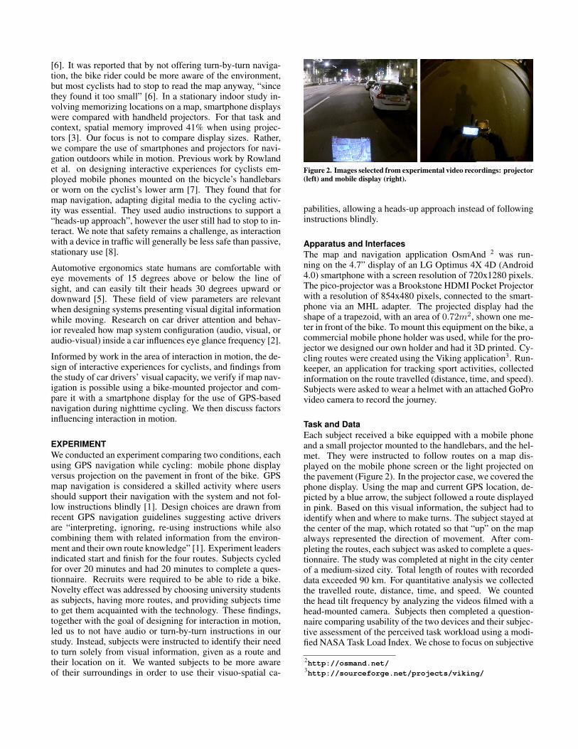
Figure 2. Images selected from experimental video recordings: projector(left) and mobile display (right).
pabilities, allowing a heads-up approach instead of followinginstructions blindly.
Apparatus and InterfacesThe map and navigation application OsmAnd 2 was run-ning on the 4.7” display of an LG Optimus 4X 4D (Android4.0) smartphone with a screen resolution of 720x1280 pixels.The pico-projector was a Brookstone HDMI Pocket Projectorwith a resolution of 854x480 pixels, connected to the smart-phone via an MHL adapter. The projected display had theshape of a trapezoid, with an area of 0.72m2, shown one me-ter in front of the bike. To mount this equipment on the bike, acommercial mobile phone holder was used, while for the pro-jector we designed our own holder and had it 3D printed. Cy-cling routes were created using the Viking application3. Run-keeper, an application for tracking sport activities, collectedinformation on the route travelled (distance, time, and speed).Subjects were asked to wear a helmet with an attached GoProvideo camera to record the journey.
Task and DataEach subject received a bike equipped with a mobile phoneand a small projector mounted to the handlebars, and the hel-met. They were instructed to follow routes on a map dis-played on the mobile phone screen or the light projected onthe pavement (Figure 2). In the projector case, we covered thephone display. Using the map and current GPS location, de-picted by a blue arrow, the subject followed a route displayedin pink. Based on this visual information, the subject had toidentify when and where to make turns. The subject stayed atthe center of the map, which rotated so that “up” on the mapalways represented the direction of movement. After com-pleting the routes, each subject was asked to complete a ques-tionnaire. The study was completed at night in the city centerof a medium-sized city. Total length of routes with recordeddata exceeded 90 km. For quantitative analysis we collectedthe travelled route, distance, time, and speed. We countedthe head tilt frequency by analyzing the videos filmed with ahead-mounted camera. Subjects then completed a question-naire comparing usability of the two devices and their subjec-tive assessment of the perceived task workload using a modi-fied NASA Task Load Index. We chose to focus on subjective
2http://osmand.net/3http://sourceforge.net/projects/viking/
feedback because this work was an initial test to check if mapnavigation is feasible while cycling.
Pilot StudyA within-groups pilot study was performed to ensure the gen-eral usefulness and feasibility of the prototype. The aim wasboth to confirm that the projected light was appropriate fornavigation, and to design the final experiment. Six persons(four females and two males) aged between 24 and 50 years(M=34.5, SD=8.89) tested our prototype. We chose severalroutes throughout the city, with distances varying betweenone to three kilometers. Initially, each subject was given twoarbitrary routes from the set of all available routes. There-after, they completed a questionnaire and we subsequentlyconducted an interview, taking into account their question-naire answers. We used the collected data for an informalassessment of our prototype to incrementally adjust the sys-tem and the experiment. We concluded that because subjectsmight not be familiar with navigation while cycling, lettingthem first ride with the projector-based system would intro-duce two new aspects at once, and thus would be more diffi-cult than beginning with the mobile phone. This observationcontributed to the decision in the final design to have fourshorter routes (less than a kilometer) instead of two longerroutes. This way, the subjects would have more time to learn,to get familiar with the prototype, and also take more time toform an opinion and make a better assessment.
Experiment ResultsThe final experiment was a 2 x 4 (device: mobile phone, pro-jector; trial: 1-4) within-subjects design using four differentroutes with a balanced distribution of the number of trialsacross route-device combinations, and a strict alternation ofmobile (M) and projector (P) across the different routes (M-P-M-P or P-M-P-M). The number of subjects was 16, out ofwhich were 7 females and 9 males of ages between 21 and33 (M=25.8, SD=2.98). subjects completed four routes and aquestionnaire whose results are presented below. Each ques-tionnaire section is reflected in the following sections.
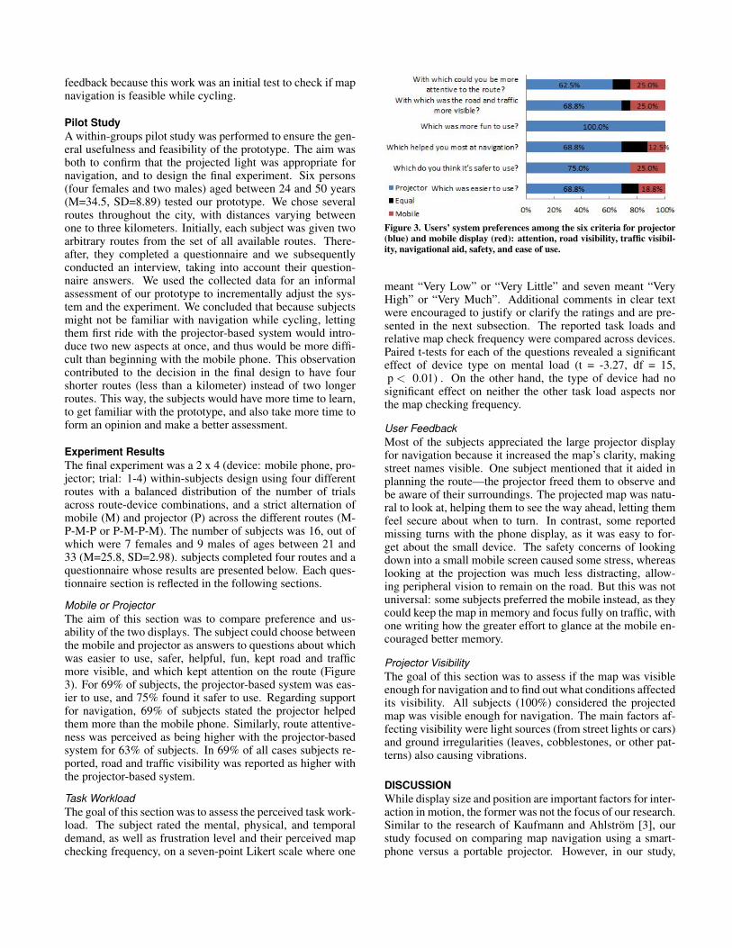
Mobile or ProjectorThe aim of this section was to compare preference and us-ability of the two displays. The subject could choose betweenthe mobile and projector as answers to questions about whichwas easier to use, safer, helpful, fun, kept road and trafficmore visible, and which kept attention on the route (Figure3). For 69% of subjects, the projector-based system was eas-ier to use, and 75% found it safer to use. Regarding supportfor navigation, 69% of subjects stated the projector helpedthem more than the mobile phone. Similarly, route attentive-ness was perceived as being higher with the projector-basedsystem for 63% of subjects. In 69% of all cases subjects re-ported, road and traffic visibility was reported as higher withthe projector-based system.
Task WorkloadThe goal of this section was to assess the perceived task work-load. The subject rated the mental, physical, and temporaldemand, as well as frustration level and their perceived mapchecking frequency, on a seven-point Likert scale where one
Figure 3. Users’ system preferences among the six criteria for projector(blue) and mobile display (red): attention, road visibility, traffic visibil-ity, navigational aid, safety, and ease of use.
meant “Very Low” or “Very Little” and seven meant “VeryHigh” or “Very Much”. Additional comments in clear textwere encouraged to justify or clarify the ratings and are pre-sented in the next subsection. The reported task loads andrelative map check frequency were compared across devices.Paired t-tests for each of the questions revealed a significanteffect of device type on mental load (t = -3.27, df = 15,p < 0.01) . On the other hand, the type of device had no
significant effect on neither the other task load aspects northe map checking frequency.
User FeedbackMost of the subjects appreciated the large projector displayfor navigation because it increased the map’s clarity, makingstreet names visible. One subject mentioned that it aided inplanning the route—the projector freed them to observe andbe aware of their surroundings. The projected map was natu-ral to look at, helping them to see the way ahead, letting themfeel secure about when to turn. In contrast, some reportedmissing turns with the phone display, as it was easy to for-get about the small device. The safety concerns of lookingdown into a small mobile screen caused some stress, whereaslooking at the projection was much less distracting, allow-ing peripheral vision to remain on the road. But this was notuniversal: some subjects preferred the mobile instead, as theycould keep the map in memory and focus fully on traffic, withone writing how the greater effort to glance at the mobile en-couraged better memory.
Projector VisibilityThe goal of this section was to assess if the map was visibleenough for navigation and to find out what conditions affectedits visibility. All subjects (100%) considered the projectedmap was visible enough for navigation. The main factors af-fecting visibility were light sources (from street lights or cars)and ground irregularities (leaves, cobblestones, or other pat-terns) also causing vibrations.
DISCUSSIONWhile display size and position are important factors for inter-action in motion, the former was not the focus of our research.Similar to the research of Kaufmann and Ahlstrom [3], ourstudy focused on comparing map navigation using a smart-phone versus a portable projector. However, in our study,

we evaluated two alternative display types for map naviga-tion during cycling and factors other than display size affect-ing this task. One such visuo-spatial factor was eye-to-digitalinformation distance (EI), which can be understood as the ra-dius of a circle whose center is the cyclist’s face and ends atthe phone view or the projected view (Figure 5). In our study,the map was either visible at an arm’s length from the eyes ofthe cyclist or on the ground in front of the them. Besides EI,another factor is normal-view-to-digital information distance(NVI). There is thus a distance between the normal view andthe information displayed by the mobile and by the projec-tion. For the cyclist, the normal view is ahead, towards theroad. The normal view is characterized by the field of view(FOV) and the line of sight directed ahead (A) (Figure 5). Ifdigital information is presented outside of the FOV, the cy-clist’s head is required to move towards that information. Inour study, the information was the map, requiring a head tiltto enable seeing the projection view (B) or the phone view(C) (Figure 5).
Figure 4. Line of sight and field of view in: A) normal view, B) projec-tion view, and C) phone view.
The mobile’s EI is less than the projector’s, so the eye fo-cuses faster on the projection. This is because the projectionis closer to the normal view and in the FOV, as suggested byone subject. The NVI for the mobile is larger than it is for theprojector, resulting in a larger angle during the head tilt. Thisdifference in information placement, together with displaysize, could be the reason why the mental demand is perceivedhigher for the mobile phone than for the projector display.For the projected map, we noticed that head tilts had shorterduration and smaller angles, probably because the projectedmap is closer to the field of view. The experiment providedstatistically non-significant data on head tilt frequency differ-ences between devices. However, the data for both deviceswas remarkably close to the eye glance frequency found byresearchers studying car driver attention and behavior for dif-ferent GPS configurations [2].
CONCLUSION AND FUTURE WORKThis paper presented a mobile system, Smart Flashlight, de-signed to evaluate bicycle map navigation using a mobilephone versus using a projector. The mobile phone display
could be used for navigation during the day, while the projec-tor could serve as both flashlight and map during the night.This interaction method for navigation could be applied toother settings, such as hiking, swimming, or driving. To re-liably measure and test objective factors such as completiontime and head tilt frequency, we suggest i) controlling sub-ject’s cycling proficiency, ii) controlling subject’s map navi-gation skills, and iii) controlling the GPS performance.
ACKNOWLEDGEMENTSSpecial thanks to Weiquan Lu, Barrie James Sutcliffe, PawelWozniak, and Asim Evren Yantac. This work was supportedby the EU FP7 People Programme (Marie Curie Actions) un-der REA Grant Agreement 290227 and 289404.
REFERENCES1. Brown, B., and Laurier, E. The normal natural troubles of
driving with gps. In Proceedings of the 2012 ACM annualconference on Human Factors in Computing Systems,ACM (2012), 1621–1630.
2. Jensen, B. S., Skov, M. B., and Thiruravichandran, N.Studying driver attention and behaviour for threeconfigurations of gps navigation in real traffic driving. InProceedings of the SIGCHI Conference on HumanFactors in Computing Systems, CHI ’10, ACM (NewYork, NY, USA, 2010), 1271–1280.
3. Kaufmann, B., and Ahlstrom, D. Studying spatialmemory and map navigation performance on projectorphones with peephole interaction. In Proceedings of theSIGCHI Conference on Human Factors in ComputingSystems, CHI ’13, ACM (New York, NY, USA, 2013),3173–3176.
4. Marshall, J., and Tennent, P. Mobile interaction does notexist. In CHI ’13 Extended Abstracts on Human Factorsin Computing Systems, CHI EA ’13, ACM (New York,NY, USA, 2013), 2069–2078.
5. Peacock, B., and Karwowski, W. Automotive ergonomics.Taylor & Francis London; Washington, 1993.
6. Pielot, M., Poppinga, B., Heuten, W., and Boll, S.Tacticycle: Supporting exploratory bicycle trips. InProceedings of the 14th international conference onHuman-computer interaction with mobile devices andservices, ACM (2012), 369–378.
7. Rowland, D., Flintham, M., Oppermann, L., Marshall, J.,Chamberlain, A., Koleva, B., Benford, S., and Perez, C.Ubikequitous computing: designing interactiveexperiences for cyclists. In Proceedings of the 11thInternational Conference on Human-ComputerInteraction with Mobile Devices and Services, ACM(2009), 21.
8. Strayer, D. L., Drews, F. A., and Crouch, D. J. Acomparison of the cell phone driver and the drunk driver.Human factors: The journal of the human factors andergonomics society 48, 2 (2006), 381–391.