
Slope Stability on DATE.
26
4#e ?715/q; /&'1cui/ /00-2--- 73fr Slope Stability on Foret Land THIS PUBLICATION IS OUT OF DATE. For most current information: http://extension.oregonstate.edu/catalog
Transcript of Slope Stability on DATE.

4#e ?715/q;/&'1cui/ /00-2---
73fr
Slope Stability on
Foret Land
THIS P
UBLICATIO
N IS O
UT OF D
ATE.
For mos
t curr
ent in
formati
on:
http:/
/exten
sion.o
regon
state.
edu/c
atalog
Sedimentation of streams resulting from mass soil move-ment is the most important problem of non-point pollution inthe Pacific Northwest, according to state and federal regulatoryagencies. Sediment in streams contributes to the deteriorationof fisheries habitat and affects downstream water quality. Largemass movements that extend downslope directly into streamscan scour channels and alter aquatic ecosystems for decades.
In order to minimize the impacts of forest practices onslope stability, forest and other resource managers must under-stand the characteristics and causes of various slope failures.
THIS P
UBLICATIO
N IS O
UT OF D
ATE.
For mos
t curr
ent in
formati
on:
http:/
/exten
sion.o
regon
state.
edu/c
atalog

Slope Stability on
Forest LandROY C. SIDLE
Extension watershed management specialistDepartment of Forest Engineering
Oregon State University
The dominant erosional process on forest land in the PacificNorthwest is mass soil movement. Mass soil movements, which com-monly occur as landslides, involve the transport of large quantitiesof soil and debris, primarily by gravity. This is in contrast to theoften more visible process of surface erosion, in which individualsoil particles are detached and transported downslope by water.While surface erosion may be a significant sediment contributor tostreams from localized sites such as cut banks and road surfaces,sedimentation due to various mass wasting processes is much greateron the forested hillslopes of the Pacific Northwest region.
A map showing the extent and severity of road-associated land-slides in the Pacific Northwest area illustrates the magnitude ofthe slope stability problem (Figure 1). The areas of highest land-
Y
r
Figure 1. Road-associated landslide hazards extend throughout Pacific North-west forest lands.
1
THIS P
UBLICATIO
N IS O
UT OF D
ATE.
For mos
t curr
ent in
formati
on:
http:/
/exten
sion.o
regon
state.
edu/c
atalog

slide potential shown on the map correspond to the steep slopes ofCascade, Coast, and Intermountain Ranges. These low-stabilityregions frequently experience intense storms and periods of ex-tended rainfall. With increasing demands for timber production andadvances in harvesting technology, more of these steep forestedslopes are subjected to a variety of forest practices.
This publication deals with basic causes of slope failures, andthe impacts of road construction, timber harvesting, and slash burn-ing, with emphasis on control measures to reduce landslide hazards.
Characteristics of Slope FailureSince it is almost impossible to control mass erosion once it
has started, it is important that land managers recognize causes andareas of instability and adjust management plans accordingly tominimize impacts on these potentially erodible areas. Land man-agers must have a basic understanding of the interacting forces thatdictate slope stability, as well as the factors that influence theseforces. Generally, three types of mass soil movements occur in thePacific Northwest: 1) shallow, rapid failures such as debris ava-lanches, debris flows, and debris torrents; 2) slow, deep-seated massmovements such as soil creep, slumps and earthilows, and 3) single-particle erosion such as dry ravel and rockfall.
Debris Avalanche--Debris FlowDebris avalanches occur rather spontaneously in shallow soils
overlying an impermeable layer such as bedrock (Figure 2). De-pending on the water content of the soil mantle at the time of failure,they may be classified as debris slides, avalanches, or flows, in orderof increasing water content. In reality, several of these modes mayoccur in the same landslide, with the failure initiating as a debrisslide or avalanche upsiope and then breaking up into a more fluidmass as it moves downslope.
Debris avalanches frequently occur on the steep, forested ter-rain in the Coast Range of Oregon, Washington, and northern Cali-fomia, as well as portions of central Idaho. Relatively hard bedrock,such as Tyee sandstone in the Oregon Coast Range and granitics ofthe Idaho Batholith, form the lower boundary for these failures.Soils developed on impermeable glacial tills, such as in coastalAlaska, are also subject to debris avalanching.
THIS P
UBLICATIO
N IS O
UT OF D
ATE.
For mos
t curr
ent in
formati
on:
http:/
/exten
sion.o
regon
state.
edu/c
atalog

DEBRIS AVALANCHE- DEBRIS FLOW
'\: ''
Weathered
bedrock,
soi4 etc
Bedrock
DEBRIS AVALANCHE
Figure 2. Debris avalanches and flows typically occur on steep slopes withshallow soils overlying an impermeable layer.
Debris avalanches on natural forested hilislopes usually aretriggered by large inputs of water into the soil mantle, from eitherintense storms or rapid snowmelt or a combination of these two.Once the failure is initiated, the relatively thin soil mantle andsurficial debris moves downslope at velocities varying from 5 to 15feet per second, depending on water content and slope gradient.Debris avalanches leave scars in the form of spoon-shaped depres-sions and their tracks may extend downslope for long distances insteep terrain (Figure 3).
For a sliding-type failure, such as a debris avalanche, the down-slope pull of gravity acting on the soil (shear stress) exceeds theability of the soil to resist sliding (shear strength), causing theslope to fail. As ground water rises in the soil mantle, the interlock-ing forces among soil particles are reduced, smce water exerts abuoyant force on each particle as it becomes submerged. Increasedsoil water can also create slope instability by increasing the soilweight on an already steep slope, thereby increasing shear stress.The impact of ground water in landslide initiation is especially im-portant in steep, upslope depressions with shallow soils. These steepheadwall areas are often points of debris avalanche initiation dueto gromd water concentration.
Relatively cohesionless soils, which tend to be low in clay con-tent, non-plastic, and granular, are more susceptible to debris ava-
c]
THIS P
UBLICATIO
N IS O
UT OF D
ATE.
For mos
t curr
ent in
formati
on:
http:/
/exten
sion.o
regon
state.
edu/c
atalog

Figure 3. Debris avalanches leave characteiistic scars on steep hillslopes.
lanching on steep slopes, since their shear strength is determinedprimarily by soil particle interlocking. These shallow soils are de-veloped on certain sandstone and granitic bedrock and are basicallyunstable on slopes greater than 75 percent and may become unstablewhen disturbed on slopes greater than 53 percent. Living root sys-tems of vegetation contribute substantially to the overall stabilityof these shallow soils by attaching directly to bedrock and tyingthe hillslope together across zones of weakness.
Debris Torrents
Debris torrents occur in steep intermittent first-, second-, andthird-order stream channels. They are usually triggered by debrisavalanches from adjacent land units or by the break-up of debrisdams in stream channels. Debris torrents move rapidly down inter-mittent channels, in a slurry-like state, containing living and deaddebris, soil, bedrock, and water. In their progress down channel,debris torrents often scour channels to bedrock and severely erodestream banks, thus inflicting severe damage to downstream fisherieshabitat and water quality in general. When debris torrents come torest downslope there is often a huge deposition of organic debrisand sediment covering up to several acres (Figure 4). Although
THIS P
UBLICATIO
N IS O
UT OF D
ATE.
For mos
t curr
ent in
formati
on:
http:/
/exten
sion.o
regon
state.
edu/c
atalog

Figure 4. Debris torrents deposit large quantities of ckhris and sediment instream channels.
systematic inventories of debris torrents have not been conductedin the Pacific Northwest, they appear to occur in tandem withdebris avalanches, .primarily in the steep, dissected terrain of theCoast and Cascade Ranges of Oregon and Washington.
Soil Creep
Although not a slope failure in the technical sense, soil creepinvolves the slow (usually less than 3 inch/year) downslope move-ment of the soil mantle resulting from long-term gravitational in-fluences. Creep rates often increase somewhat during the prolongedwet winter months. In spite of this slow movement, relative to othermass wasting processes, soil creep can contribute sizeable sedimentloads to streams. Since the entire hillslope is often in motion increep-prone areas, stream channels encroached upon by soil creepreceive a continuous addition of sediment.
Rapidly creeping hillslopes are characterized by hummocky,rolling topography with poorly formed or immature drainage pat-terns, sag ponds, springs, and localized slumping below wet areas(Figure 5). Other subtle indicators of soil creep include curvedtrees, tilted fence posts and telephone poles, differential soil mantle
THIS P
UBLICATIO
N IS O
UT OF D
ATE.
For mos
t curr
ent in
formati
on:
http:/
/exten
sion.o
regon
state.
edu/c
atalog

SOIL CREEP
Weatheredbedrock,
so/I, etc.
Bedrock
LOCAL SLUMP -EARTHFLOW
Stream Channel
Figure 5. Hummocky topography with springs, curved or tilted trees, andlocalized slumps characterize land undergoing active soil creep.
movement evidenced by the formation of stone lines along roadcuts, and broken or displaced walls or foundations.
Soil creep is also significant because it fills upslope depressionswith soil and debris over a period of years. These sites are thensub ject to future debris avalanching. Creep can also build up stressesin potential slump-earthflows causing them to fail under high soilmoisture conditions.
Although creep can occur in shallow 'rôarse-textured and or-ganic soils found in coastal Oregon, Washington, and southeastAlaska, the deep-seated soil creep that often triggers slumps andearthfiows usually is found in high rainfall regions with deep, clay-rich soils. Cohesion in these fine-grained soils is a function of mois-ture content. Cohesive forces are relatively strong in dry soils andtend to increase slightly with increasing water content to a maxi-mum and then decrease rapidly as the moisture content is furtherincreased. The point at which cohesive forces are maximum usuallycorresponds to the minimum moisture content at which the soilcan be deformed without rupture, known as the soils' plastic limit.The type of clay present in cohesive soils can play an important rolein determining shear strength. Soils high in expanding clays, suchas montmorillonite, eperience dramatic losses in shear strengthupon wetting near saturated levels due to the extremely largeamounts of water absorbed within the clay particles. Non-expanding
THIS P
UBLICATIO
N IS O
UT OF D
ATE.
For mos
t curr
ent in
formati
on:
http:/
/exten
sion.o
regon
state.
edu/c
atalog

clays, such as illite and kaolinite, have much lower shrink-swellpotentials and thus higher shear strengths when wet. Because ofthis decrease in soil cohesion on extensive wetting, soil creep rateswill accelerate during prolonged wet periods, during which groundwater is present in the lower portion of the soil mantle.
The Kiamath Mountains of southwest Oregon and northernCalifornia have regions of extensive soil creep associated with thehighly faulted and sheared metamorphosed sedimentary bedrockknown as the Dothan and Franciscan Formations. Also, soil de-veloped on weathered serpentine-rich rocks, and certain interbeddedmudstones found in the higher precipitation portions of the KiamathMountains are conducive to soil creep. Localized areas of deep soilcreep are found in the western Cascades in association with soilsdeveloped on pyroclastic deposits (tuffs, breccias, and ashes) andin the foothills along the west side of the Willamette Valley of Ore-gon in conjunction with deeper soils formed on weathered igneousrocks and soft siltstones.
Slump--Earthflow
Although they are technically two distinct modes of slopefailure, slumps and earthilows commonly occur together, or oneinitiates the other. Slumping involves the simple rotation of a solidblock of earth over a broad concave failure surface. When thematerial begins to move downslope, it breaks up and is transportedas a disrupted mass known as an earthflow. The earthflow may thenincorporate additional masses of soil as it moves downslope throughthe processes of flowage and progressive slumping. If the blocks ofearth are left intact as they move downslope, along the failure plane,the failure is termed a "block glide."
Earthflows typically occur on moderately sloping terrain, oftenslopes less than 40 percent, in which dep, clay-rich soils have de-veloped. Figure 6 illustrates a typical slump-earthflow with charac-teristic scarps, slump benches, tension cracks, and sag ponds. Vegeta-tive indicators of slump-earthflow terrain include tipped and jack-strawed trees around the benches and lateral boundaries of thefailure. Poor drainage characterizes the hummocky topography ofmost slump-earthflows. The resulting concentrations of subsurface
ii
THIS P
UBLICATIO
N IS O
UT OF D
ATE.
For mos
t curr
ent in
formati
on:
http:/
/exten
sion.o
regon
state.
edu/c
atalog

SLUMP-EARTH FLOW
Stream Channel LLL" J
weathered
'\\5A9i N2 '/
tdrock
_.L '' Itand soil
A f, I
(,-'' ci r.
I'll' / 'I
I
edrock
NPI(6,,4JA1I' \ll 17
11:WihII :1' Slip surface
.1.1.1 IIIi tension cracks
Figure 6. Slumps and earthilows generally occur together, creating such land-form features as sag ponds, tension cracks, and headwall scarps.
water during prolonged rainfall develop positive pore water pres-sures within the earthilow mass that may initiate or accelerate move-ment. These areas sometimes can be spotted by the hydrophytes or"water-loving vegetation" growing in the vicinity. Movement ofearthilows can occur at rates as slow as soil creep and, in extremecases, as fast as several feet per minute.
Large slump-earthilows are important mass wasting processesin the same areas of northern California and western Oregon andWashington in which deep-seated soil creep occurs. As discussedearlier, deep-seated creep contributes to the initiation and accelera-tion of slump-earthflows. Geologic and soils conditions conduciveto creep likewise promote slump-earthfiows. Smaller localized slump-ing may occur in many areas of the Pacific Northwest in deep clay-rich soils (especially swelling clays) and in highly weathered geo-logic material interbedded with more resistant strata. Removal ofstructural support at road cuts or overloading slopes with fill materialcan initiate localized slumps in cohesive soils. Additional deep-seated slump-earthilows occur in the hillslopes bordering the Colum-bia Gorge in Oregon and Washington. These failures remain activedue to slow, continual geologic and fiuvial erosion in the gorge.
THIS P
UBLICATIO
N IS O
UT OF D
ATE.
For mos
t curr
ent in
formati
on:
http:/
/exten
sion.o
regon
state.
edu/c
atalog

Dry Ravel
Dry ravel involves the downslope movement of individual soilgrains, aggregates, and coarse fragments by gravitational forces.This mass erosion process is common on steep, denuded, or sparselyvegetated hilislopes with relatively non-cohesive or single-grainedsurface soils. Dry ravel is caused by the loss of interlocking frictionalresistance among soil aggregates or grains, which may be createdby freezing-thawing and wetting-drying cycles. Soil and coarsefragments can move by sliding and rolling in thin sheets (knownas dry creep) along the surface, making this erosional process almostimperceptible to the casual observer. Dry ravel and creep sometimesare exposed and can be observed when trapped on the upslope sideof trees and debris (Figure 7).
Soils most susceptible to dry ravel include those developed onweathered granitic and volcanistic rocks in drier climatic regionswhere mechanical weathering processes, such as freeze-thaw, domi-nate. Examples are the single-grained and sandy-textured soils ofthe Idaho Batholith and portions of southwest and northeast Ore-gon, as well as certain non-cohesive soils of the Coast and CascadeRanges. Dry ravel will occur on most hilislopes of the Pacific North-west following deforestation and litter disturbance as well as slopeoversteepening. These effects are described in the section on man-agement related impacts.
Figure 7. Tree stumps trap dry ravel on the upsiope side at a burned site.
THIS P
UBLICATIO
N IS O
UT OF D
ATE.
For mos
t curr
ent in
formati
on:
http:/
/exten
sion.o
regon
state.
edu/c
atalog

Much of the dry ravel produced on a hilislope may not directlyreach stream channels. However, the potential for reduction in siteproductivity by the loss of significant quantities of surface soil under-lines the importance of dry ravel in susceptible areas. In addition,ravel can contribute to the filling of upsiope depressions which arepotential debris avalanche sites.
Rockfall
Rockfall is defined as the relatively free falling of newly de-tached bedrock from a cliff or steep slope (Figure 8). Rockfalls arenot a particularly important mass wasting process on undisturbedforested slopes of the Pacific Northwest, largely because exposedrock cliffs or steep rock slopes are rarely present. In localized areasoversteepened by rivers or valley glaciers, rockfalls may occur.Easily weatherable rocks, such as granitics, and highly fracturedrocks, such as certain sandstones and jointed igneous rocks, arelikely candidates for rockfall. Freeze-thaw action may enlarge jointsand help initiate rockfalls. Depending on the competence of thebedrock, distance of fall, and size of the individual rocks, blocks may
ROCK FALL
Figure 8. Roadcuts through highly fractured or unstable bedrock contribute torockfall.
10
THIS P
UBLICATIO
N IS O
UT OF D
ATE.
For mos
t curr
ent in
formati
on:
http:/
/exten
sion.o
regon
state.
edu/c
atalog

be fractured on impact and move further downslope as a rockslide.As with rockfalls, rockslides are more important erosional processesin rugged alpine areas; however, they may impact upper elevationforested slopes in certain areas of the high Cascade Range and themountains of coastal Alaska.
One of the most catastrophic landslides ever to occur was theTurtle Mountain rockslide-rockfall of 1903, which carried approxi-mately 40 million cubic yards of rock and killed 70 people in thetown of Frank, Alberta. A combination of factors including softinterbedded sedimentary rocks, extensive frost action in well de-veloped joints, previous earthquake-history, and partial mining of acoal seam contributed to this massive failure. The more recent,earthquake-triggered, Madison River rockslide of 1959 killed 28people and was similar in size to the Turtle Mountain slide. Thesetypes of catastrophic rockslide-rockfalls are unlikely to initiate asa result of forest management activities; however, any major excava-tion into unstable bedrock should be examined by geotechnicalspecialists who can evaluate the strength of the rock and determinethe dip of joints, fractures, and bedding planes. Small rockfalls arecommon along roadcuts in unstable bedrock, presenting maintenanceproblems for logging roads.
Impaas of Forest PraaicesCertain roadbuilding, timber harvesting, and site preparation
practices can have significant impacts on slope stability in thePacific Northwest. Shallow landslides are caused by improper roadlocation and construction practices in steep terrain, and by clear-cutting large blocks of unstable land. Stumps and earthfiows canbe initiated or accelerated. by altering ground water conditionsthrough roadbuilding and clearcutting. Slash burning greatly ac-celerates dry ravel and dry creep on certain soils Methods toameliorate these impacts involve both pre-planning control measuresand certain structural measures in critical areas.
Debris Avalanche--Debris FlowRoadbuilding
With the increasing use of uphill highlead and skyline harvest-ing systems, timber removal from steep slopes in the Pacific North-west is becoming commonplace. Although these harvesting methodsnormally do not require as extensive road systems as ground-based
11
THIS P
UBLICATIO
N IS O
UT OF D
ATE.
For mos
t curr
ent in
formati
on:
http:/
/exten
sion.o
regon
state.
edu/c
atalog

logging, considerable road construction must be done on steep,potentially unstable slopes. These roads must be wide enough toaccommodate the large skyline or highlead towers, thus requiringextensive amounts of soil and rock to be excavated.
Roadbuilding is widely recognized as one of the primary causesof debris avalanches in managed forest land. Several studies con-ducted in the granitic and metamorphic forested hilislopes of cen-tral Idaho indicated that road construction was responsible forbetween 60 and 90 percent of all mass failures. Most of these failureswere shallow debris avalanches and debris slides. In a landslideinventory conducted by the U.S. Forest Service in Oregon andWashington following the 1964-1965 winter floods, road relatedmass failures were involved in approximately 60 percent of the dam-age reports.
A primary cause of debris avalanches is placing road fill materialon steep slopes with shallow, non-cohesive soils. The weight of thefill material acts to upset the balance of forces that determine sta-bility. The stability of fill slopes in steep terrain is further jeopar-dized by water routed onto these areas from road drainage systems.Poor drainage design and plugged cross-drains can cause saturationof critical areas of the fill slope leading to increased weight and porewater pressures, and the eventual failure of these sites (Figure 9).Roadcuts in steep, unstable terrain may also trigger debris ava-lanches by removing dowrislope support.
Timber harvestingForest vegetation lends stability to steep hillslopes by providing
additional cohesion from root systems and by reducing soil watercontent through transpiration. When vegetation is removed fromthese slopes, rooting strength is reduced over a period of time andsoil moisture may be increased. The resulting decreases in soil shearstrength can increase the probability of debris avalanche occurrenceon steep slopes (greater than 53 percent) with relatively non-cohesive soils. A study in southeast Alaska showed greatly increasedfrequencies of debris avalanches occurring from 3 to 5 years afterclearcutting. An analysis of landslide occurrence in central Idaho(largely grallitic soils) indicated that slides were most frequent4 to 10 years after clearcutting. Other studies have shown increasedlandslide activity up to 16 years after vegetation removal.
Following timber harvest, root systems of trees begin to decay,resulting in the loss of root anchoring into underlying bedrockand the decrease in overall root density of the soil mass. The decayrate of dead roots as well as the amount and type of live vegetation
12
THIS P
UBLICATIO
N IS O
UT OF D
ATE.
For mos
t curr
ent in
formati
on:
http:/
/exten
sion.o
regon
state.
edu/c
atalog

Figure 9. Poor road drainage can result in catastrophic fill-slope failures.
left on site determine the period of highest landslide susceptibility.This underlines the importance of rapid regeneration on steepharvested hilislopes. Root strength tests indicate that coastalDouglas-fir roots are stronger than western hemlock roots, whichin turn are stronger than Sitka spruce roots. Many of the non-commercial trees and brush that are often suppressed or killed byherbicides or slash burning have stronger root systems than fir orspruce.
The reduced transpiration following clearcutting could havean effect on debris avalanche initiation in drier regions, such as east-ern Oregon and Washington and southern Idaho. In these areas,soils are rarely at or near saturation, so clearcutting could increasesoil moisture levels during storm or spring runoff periods. Cou1edwith steep slopes, this could initiate debris avalanches.
Although mass erosion from roaded areas is usually more visualand much greater in volume on a per acre basis than failures inclearcuts, the total amount in sediment produced from the twosources often is similar in magnitude. Studies in the western CascadeRange indicated that erosion produced by debris avalanches withina clearcut was almost half as much as the total landslide erosion
13
THIS P
UBLICATIO
N IS O
UT OF D
ATE.
For mos
t curr
ent in
formati
on:
http:/
/exten
sion.o
regon
state.
edu/c
atalog

from road right-of-ways. A survey in the central Oregon CoastRange following the winter storm of 1975 revealed that 77 percentof the landslides occurred in clearcut units, 14 percent in road right-of-ways, and 9 percent in natural forested areas.
Control opportunitiesSince forest roads are a major cause of debris avalanches in
steep terrain, improved location and construction practices canreduce the magnitudes of these failures greatly. If steep slopes areto be harvested, adequate road systems are a necessary part of theoverall operation. Systematic planning of forest roads that tend tominimize mileage and number of steep grades, as well as utilizeridge-top locations whenever possible, reduces the hazards of debrisavalanching. Avoid excess excavation in steep terrain. A hydraulicshovel will disturb much less rock and soil and has better controlof this waste during road excavation in steep terrain than will abulldozer. Full-benching of roads and end hauling waste material tostable sites are the most effective means of minimizing debris ava-lanches on unstable midslopes that must be roaded. Proper roaddrainage design can substantially reduce fill failures on forest roads.
Adequate sizes and numbers of cross drains are essential oninslope roads to disperse this intercepted water as well as the over-land flow from the road surface. Maintenance and cleaning of ditch-lines and culverts as well as the installation of debris racks areneeded to insure proper functioning of the road drainage system.Culverts and debris racks should be checked and cleaned duringmajor storms. For certain highly erosive soils, such as the coarse-grained granitics, it is desirable to install additional cross drains toprevent excessive scouring and saturation of the road prism. Evenwell-designed crowned or insloped roads, which utilize cross drainsfor surface water removal, can create slope stability problems dueto the large quantities of water discharged onto slopes at the crossdrain outlets. To minimize this problem, road fills should be pro-tected from culvert discharge by extending cross drains beyond thefill and riprapping the outfall. Many of the forest road-related debrisavalanches that occur are due to the combination of oversteepeningand periodic saturation by culvert discharge on road fills.
Since clearcutting can play a role in initiating debris avalancheson steep hillslopes, certain National Forests are now designatingcritical head-wall "leave areas" within clearcut units in unstableterrain. These "leave areas" must be properly designed to avoiddestruction from windthrow and slash burning from surroundingareas. Alternatives to slash burning as a site preparation procedure
14
THIS P
UBLICATIO
N IS O
UT OF D
ATE.
For mos
t curr
ent in
formati
on:
http:/
/exten
sion.o
regon
state.
edu/c
atalog

may need to be considered on steep unstable sites in order to pre-serve the rooting strength of the existing vegetation. No informationis currently available regarding the impacts of various partial cuttingpractices on slope stability.
Debris Torrents
RoadhuildingSince debris torrents are commonly triggered by debris ava-
lanches, roadbuildi.ng practices that cause debris avalanches alsoinitiate torrents in intermittent upland channels. These practicesprimarily involve oversteepening fill slopes and inadequate roaddrainage. In addition, debris torrents can be initiated directly bydischarging excessive amounts of surface water into steep first-orderdrainages. Although these drainages are natural waterways, over-loading them during storms as a result of poor road drainage cancreate positive pore water pressures in the thin soil mantle. This,together with accumulations of debris, can cause debris torrentsthat will scour channels to bedrock and inflict severe damages todownstream water quality and habitat.
Timber harvestingLoss of rooting strength following clearcutting on steep slopes
with relatively non-cohesive soils causes in-unit debris avalanching.As these avalanches move downslope they often enter intermittentfirst- or second-order upland channels. As the transported soil anddebris move through these restricted channels the failure is termeda debris torrent. Residue from timber harvesting can also initiatedebris torrents if allowed to accumulate in upland swales. In thesecases, the torrent can be initiated by mechanical overloading due tothe weight of the debris or by breakup of the debris mass duringintense storm flows.
Control opportunitiesRoad planning and construction practices recommended for re-
ducing the incidence of debris avalanches will also lower the chancesof debris torrent occurrence. Adequate numbers of cross drains areespecially important on roads located on steep hillslopes to avoidconcentrating excessive overland flow into upland swales. Outslopedroads are effective on ridgetop and other stable road-base locationsto disperse water more evenly over the hillslope. Isolated areas ofinstability along forest road right-of-ways may warrant structural
15
THIS P
UBLICATIO
N IS O
UT OF D
ATE.
For mos
t curr
ent in
formati
on:
http:/
/exten
sion.o
regon
state.
edu/c
atalog

support. This is particularly important if the impending failurewould directly impact a high value water resource such as a primefisheries stream or a municipal reservoir. Stabilization structureseffective in controlling debris torrents and avalanches caused by fillslope failure include bin walls, gabions, cantilever walls, and tie-back walls (Figure 10). Design, selection, and construction of aretaining wall for a given location is an expensive proposition thatrequires analysis by a qualified design engineer.
The use of remote aids such as aerial photos can be helpful indelineating unstable slopes susceptible to debris avalanches andtorrents. Large-scale features such as fault lines, oversteepenedslopes, old failure tracks, and poorly drained areas can be spottedusing these aids. Once potential problem areas have been designated,an on-the-ground inspection may be necessary to evaluate the po-tential stability of a site and its probable response to a given man-agement practice.
During this reconnaissance, on-site vegetative, soil, and geo-logic indicators of slope instability may be useful. Tipped trees andtension cracks in the soil mantle around steep headwall areas indi-cate imminent slope failure. Areas such as these may best be desig-nated as "leave areas" in the overall harvest plan. Hydrophytes,
Figure 10. Retaining walls are effective means of controlling debris avalanchingfrom unstable road fills.
16
THIS P
UBLICATIO
N IS O
UT OF D
ATE.
For mos
t curr
ent in
formati
on:
http:/
/exten
sion.o
regon
state.
edu/c
atalog

such as devils club and skunk cabbage, indicate potentially unstableareas of ground water concentration. The formation of gray oryellow-brown splotches (known as mottles) in the soil profile alsoindicate periods of saturation. Weak bedrock and bedding planesoriented approximately parallel to the sidehill are geologic charac-teristics typical of unstable hilislopes. By using these "on-the-ground" indicators together with aerial photos the land managercan designate highly unstable areas in which timber harvestingand road building may be restricted or modified.
Harvesting technology can be applied constructively to mini-mize the chance of debris torrent occurrence. Cable yarding largelogging slash out of upland swales reduces the chance of futuresluice-outs. In areas that are too unstable or remote for extensiveroad systems, new timber harvesting methods, such as balloon andhelicopter logging, can be utilized. While these aerial logging tech-niques offer the potential for resource protection on unstable slopes,their costs are prohibitive in some areas.
Soil Creep
RoadbuildingConstructing forest roads on creep-prone hillslopes can acceler-
ate the soil creep process largely by diverting road drainage waterinto the soil mantle. Increased soil moisture conditions downslopeof the road drainage outlets will accelerate soil creep and can ulti-mately result in the initiation of a slump-earthilow failure if porewater presssures are allowed to build up. Road cuts into creepinghilislopes likewise can result in accelerated rates of soil creep oreven localized slump-earthfiows due to removal of downslope sup-port.
Timber harvestingWhen creep-prone sites are clearcut, the resulting reduction of
on-site transpirational water losses will affect movement rate inthese deep, clay-rich soils. In regions with rain-dominated winters,such as western Oregon and Washington, increased soil moisturelevels due to reduced transpiration will occur primarily during falland spring, thus extending the time period when soils are at or nearsaturation. This extended time period of high soil moisture couldresult in a longer period of activity for deep-seated soil creep andslow-moving earthflows. Losses in rooting strength following clear-cutting on creep-prone ground are minor in terms of their effects
17
THIS P
UBLICATIO
N IS O
UT OF D
ATE.
For mos
t curr
ent in
formati
on:
http:/
/exten
sion.o
regon
state.
edu/c
atalog
on overall slope stability, since soil mantles usually are deep androot anchoring to bedrock is not an important consideration. Onshallow, creeping hilislopes, such as certain soils of coastal Alaska,clearcutting could have a pronounced impact on rate of movement.
Control opportunitiesSpecial road construction practices may be necessary in
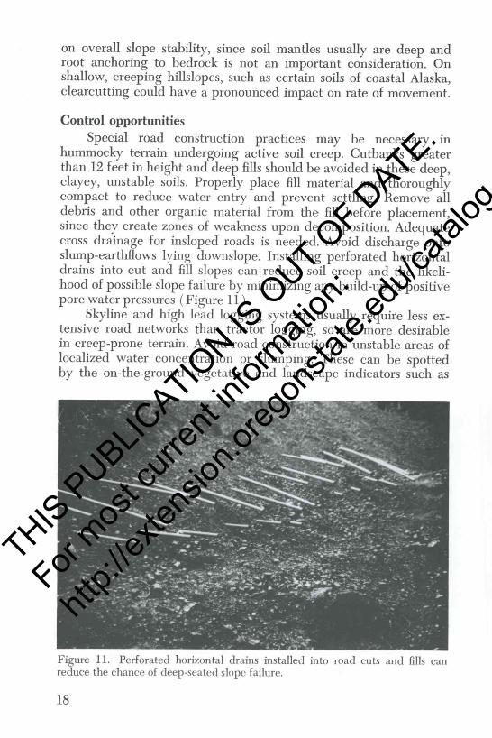
hummocky terrain undergoing active soil creep. Cutbanks greaterthan 12 feet in height and deep fills should be avoided in these deep,clayey, unstable soils. Properly place fill material and thoroughlycompact to reduce water entry and prevent settling. Remove alldebris and other organic material from the fill before placement,since they create zones of weakness upon decomposition. Adequatecross drainage for insloped roads is needed. Avoid discharge ontosluinp-earthfiows lying downslope. Installing perforated horizontaldrains into cut and fill slopes can reduce soil creep and the likeli-hood of possible slope failure by minimizing any build-up of positivepore water pressures (Figure 11).
Skyline and high lead logging systems usually require less ex-tensive road networks than tractor logging, so are more desirablein creep-prone terrain. Avoid road construction in unstable areas oflocalized water concentration or slumping. These can be spottedby the on-the-ground vegetative and landscape indicators such as
Figure 11. Perforated horizontal drains installed into road cuts and fills canreduce the chance of deep-seated slope failure.
IE
THIS P
UBLICATIO
N IS O
UT OF D
ATE.
For mos
t curr
ent in
formati
on:
http:/
/exten
sion.o
regon
state.
edu/c
atalog

pistol-butted trees, hydrophytes, sag ponds, and springs. Althoughtimber removal may accelerate soil creep on some unstable hill-slopes, the land manager must weigh the tradeoffs between timberharvesting benefits and possible resource damages on each indi-vidual site.
Slump--Earthflow
RoadhuildingRoadbuilding can play a major role in initiating slump-earth-
flows or reactivating old failures. Since slump-earthilows typicallyoccur in deep, clay-rich soils, the removal of downslope support bycutting roads through the toe of old earthilows can reinitiate themor increase their rate of movement. Fill material placed over thetop of an old slump block can create an active slump-earthflow thatcan extend directly down into stream channels. As with mostunstable terrain, poor road drainage, together with overloading orundercutting slopes, is a major cause of slump-earthilows. In areas ofinadequate drainage, deep, clayey soils develdp positive pore waterpressures during the wet season. Coupled with loss of cohesion inthe wetter soil mantle, this can lead to a rotational slump andsubsequent earthflow failure.
Timber harvestingThe impact of clearcutting on slumps and earthflows is pri-
marily to reactivate dormant failures or to accelerate the movementrate of active failures. This is primarily caused by increasingmoisture contents in the soil mantle near the failure zone as de-scribed for soil creep. The loss of rooting strength following clear-cutting is not felt to be an important factor in accelerating slump-earthflow movement, since only minimal root strength contribu-tions may occur in these deep clayey soils by lateral tying of rootsacross zones of weakness. Since slump-earthflows tend to be largelandscape features, it is often difficult to separate management-related causation factors such as poor road drainage and clearcut-ting. As with shallow failures, no information is currently availableregarding the impacts of partial cutting practices on earthilow move-ment.
Control opportunitiesUtilize resources such as aerial photos, soil surveys, and geologic
hazard maps to delineate active or dormant slump-earthilows. These
19
THIS P
UBLICATIO
N IS O
UT OF D
ATE.
For mos
t curr
ent in
formati
on:
http:/
/exten
sion.o
regon
state.
edu/c
atalog

can be recognized by such features as slump terraces, sag ponds,and poorly drained soils. An on-the-ground reconnaissance canfurther reveal unstable land indicators like tension cracks or "cat-steps" in the soil around the headwalls of slumps, tipped and jack-strawed trees, and hydrophytes growing in areas of ground wateraccumulation. Once the most unstable land areas are outlined, makedecisions regarding roadbuilding and timber harvesting.
On slump-earthilow terrain use roadbuildi.ng practices recom-mended for creeping topography, such as limiting the depth of cutsand fills, minimizing road mileage, and thoroughly compacting andremoving debris from fills. At slump-prone sites, such as soils over-lying weathered siltstones, it is desirable to install additional crossdrains on insloped roads to prevent excessive scouring and satura-tion of the road prism. Drainage systems maintenance is needed toinsure optimum handling of surface water. Installing perforatedhorizontal drains in cut and fill slopes reduces the chance of slopefailure at susceptible sites (Figure 11).
Effective road location practices in potentially unstable terraincan reduce the chances of slope failure. Avoid designated unstableareas and select an alternative route if at all possible. If an unstableland mass must be crossed by a road, locate the road so as to mini-mize the potential for slumping. Loading the toe of an old slump-earthflow by situating the road prism near the bottom of the po-tential rotational failure will minimize the impact of road construc-tion. Location of the road prism at the head of the potential failureor undercutting the toe of the unstable zone would increase thechance for slope failure. Sag ponds and depressions around unstableland masses can be drained by surface ditches to reduce the chanceof slumping.
Structural control of localized slumps along road right-of-waysis sometimes necessary. A relatively low-cost technique for stabiliza-tion of existing slumps is to use rock buttresses to provide supportfor road cut and fill slopes. The weight of the rock provides thestructural support that was removed during road excavation (Fig-ure 12).
Timber harvest on slump-earthilow terrain seems to have lessimpact on slope stability than the associated roadbuilding prac-tices. Pre-planning road systems in conjunction with cable loggingoperations can reduce overall road mileage and number of steep
THIS P
UBLICATIO
N IS O
UT OF D
ATE.
For mos
t curr
ent in
formati
on:
http:/
/exten
sion.o
regon
state.
edu/c
atalog
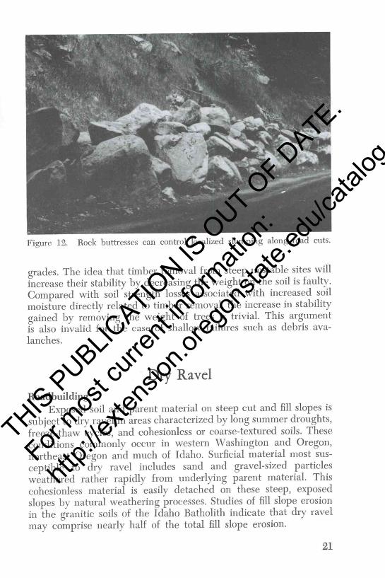
Figure 12. Rock buttresses can control localized slumping along road cuts.
grades. The idea that timber removal from steep unstable sites willincrease their stability by decreasing the weight on the soil is faulty.Compared with soil strength losses associated with increased soilmoisture directly related to timber removal, the increase in stabilitygained by removing the weight of trees is trivial. This argumentis also invalid for the case of shallow failures such as debris ava-lanches.
Dry Ravel
RoadhuildingExposed soil and parent material on steep cut and fill slopes is
subject to dry ravel in areas characterized by long summer droughts,freeze-thaw cycles, and cohesionless or coarse-textured soils. Theseconditions commonly occur in western Washington and Oregon,northeast Oregon and much of Idaho. Surficial material most sus-ceptible to dry ravel includes sand and gravel-sized particlesweathered rather rapidly from underlying parent material. Thiscohesionless material is easily detached on these steep, exposedslopes by natural weathering processes. Studies of fill slope erosionin the granitic soils of the Idaho Batholith indicate that dry ravelmay comprise nearly half of the total fill slope erosion.
21
THIS P
UBLICATIO
N IS O
UT OF D
ATE.
For mos
t curr
ent in
formati
on:
http:/
/exten
sion.o
regon
state.
edu/c
atalog

Slash burningIn the Douglas-fir region of the Pacific Northwest, logging de-
bris often is consumed on-site by broadcast burning. Although thissite preparation technique prepares a clean seedbed for regenera-tion, it can accelerate certain soil mass movements by removingprotective vegetation from the soil surface. Dry ravel from steephillslopes is increased following slash burning (Figure 7). Most ofthe ravel is produced immediately following burning, especially ifthe soil is dry. As the burned site revegetates, dry ravel decreasesmarkedly. The amount of dry ravel produced is directly relatedto the intensity of the burn with hotter burns creating more erodibleconditions. Non-cohesive soils, such as those derived from granitics,pumice, and certain bedded sediments, are most subject to dry ravel.
Control opportunitiesMulching and planting exposed cut and fill slopes with grasses
and seedlings can reduce dry ravel significantly. Avoid long fillslopes such as "sliver fills," since the amount of dry ravel producedis proportional to the size of the exposed fill. Since most dry ravelwill occur during summer months, clean the ditchlines adjacent toravel-prone cut slopes before fall and winter rains.
Broadcast slash burning may have to be restricted or modifiedon ravel-prone sites. If fuel loads are not too high and soils aresomewhat moist, the forest litter layer is protected from completedestruction during burning. Preservation of some of the litter layeris critical in controlling dry ravel. Unfortunately, the timing of con-ventional slash burning normally does not coincide with desirablesoil moisture conditions, and management adjustments may benecessary. Consider alternatives to slash burning, such as herbicideapplication coupled with high utilization of felled timber. Machinepiling of debris and mechanical scarification on sites susceptible todry ravel are not recommended, since they disturb as much surfacesoil as broadcast burning.
Rockfall
RoadbuildingForest roads that require excavation into bedrock have exposed
cutslopes subject to rockf all depending on geologic conditions.Geologic materials susceptible to rockfall include "soft" interbeddedsiltstones and sandstones, schists, and pyroclastics. Fracturing andjointing in igneous rocks, such as granitics, increases their suscepti-
22
THIS P
UBLICATIO
N IS O
UT OF D
ATE.
For mos
t curr
ent in
formati
on:
http:/
/exten
sion.o
regon
state.
edu/c
atalog

bility to rockfall. Failures are most likely to exist when beddingplanes of the rock dip downslope toward the road. Blasting requiredfor road right-of-ways may impart additional stresses in the bedrock.The activity of rockfall along a given road cut can be evaluated bythe presence or absence of vegetation on the scarp and the damagedone by falling rocks. In active areas, trees are debarked and coni-fers and other long-lived trees may be absent near road right-of-ways. Ditches are usually dotted with rock fragments produced fromcuts undergoing active rock fall.
Control opportunitiesIn order to minimize the occurrence of rock fall along road cuts,
careful road location and planning is required. Avoid making largecuts through unstable rock sequences. Examples include massivelava flows, such as basalt, overlying highly fractured igneous rocksand interbedded sandstone and soft clay or mudstone. Relocateroads to avoid these problem sites if at all possible. Problems as-sociated with bedding planes of rock dipping downslope towardthe road sometimes can be solved simply by relocating the roadon the other side of the hill, provided that it meets the transporta-tion objectives. Review geological maps before major excavationsto determine rock type and orientation of bedding planes.
If roads must be cut through unstable bedrock several con-struction techniques can be employed to minimize the potential forrock fall. Benching slopes is particularly effective in controlling rockfall in areas with interbedded "hard" and "soft" rock sequences.Construct surface drains around the top of cut slopes to divert waterdirectly into drainage ditches. This reduces freeze-thaw and chemi-cal weathering processes in the exposed bedrock. Use controlledblasting techniques, such as pre-splitting, to minimize the breakageof bedrock and produce a neat, smooth backslope. Consult geo-technical specialists before attempting excavation practices.
Structural methods for controlling rock fall along forest roadscan be used in small isolated areas of instability. Rock bolting canbe used in blocky, fractured rock to prevent rock fall onto the road-way. Do not use rock bolts in poorly consolidated or highly weather-able materials, such as shales and certain sandstones. Retaining wallsare seldom applicable to rock falls. Consult engineering specialistsbefore considering this more expensive method of structural control.
23
THIS P
UBLICATIO
N IS O
UT OF D
ATE.
For mos
t curr
ent in
formati
on:
http:/
/exten
sion.o
regon
state.
edu/c
atalog

0I
Published and distributed in furtherance of the Acts of Congress of May 8 and June 30, 1914,by the Oregon State University Extension Service, H. A. Wadsworth, director, the WashingtonState University Cooperative Extension Service, J. 0. Young, director, the University of IdahoCooperative Extension Service, James L. Graves, director, and the U.S. Department of Agri-culture cooperating. Extension programs are available equally to all persons.
THIS P
UBLICATIO
N IS O
UT OF D
ATE.
For mos
t curr
ent in
formati
on:
http:/
/exten
sion.o
regon
state.
edu/c
atalog