SLNHS Field Visit Report “Karavan” to Kalpitiya, Sri Lanka ... Field Visit Report 2018 -...
13
SLNHS Field Visit Report “Karavan” to Kalpitiya, Sri Lanka 17 th to 19 th November 2018 Participants Dr. Malik Fernando, Chris & Enoka Corea, Ninel Fernando, Rohan & Kamini De Soysa, Skanda De Saram, Bharatha & Damayanthi Attanayake, Yasmin Samarawickrema, Chanaka Senanayake, Mohan De Zylva, Sri Srikumar, Nelun Gunasekera, Ayoma Nethsinghe, Padmini Seneviratne and Lal Motha - a total of 17 happy souls venturing out together on the “Karavan” to Kalpitiya. Travel Route Colombo – Borella – Dematagoda - Kelani Bridge - Katunayake Expressway – Negombo – Chilaw – Madurankuliya – Palavi Junction – Norochcholai – Kalpitiya. Theme The main object of the field visit was to visit the isolated islands off the Kalpitiya coast, primarily Baththalangunduwa. In addition, a visit to the Uchchimunai beach-head, dolphin watching, historical sites in the Kalpitiya peninsula and bird watching was also envisaged. A detour to the Anawilundawa wetlands, along the way, was a fitting start. The cyclonic conditions in South India and the stormy weather predicted for the Jaffna District, which was expected to move towards Mannar and Puttalam, were climatic conditions of which we were constantly aware and took heed of in proceeding with our field visit. 17 th November 2018 We departed from Colombo, on time at 0545 hours, having picked up some participants along the way from designated spots around Colombo and four more along the way; making up a total of 16 participants and our driver, Mahinda, in our 20 seater “karavan”. Mohan joined us later in the evening at Kalpitiya. The mood was joyous, as usual, with many familiar faces and lively banter prevailed as we journeyed on. Enoka obliged by reading out excerpts from the book, “Sri Lanka a Wildlife Interlude” by S.D.Saparamadu (brought along by Chanaka), which was informative and well appreciated. We stopped at Thavalama Bojunhala for a hearty breakfast of local fare. The sanitary conditions of its washrooms left much to be desired and were avoided by many. The Bojunhala on the opposite side of the road was of a much better standard. The final stop-over at a Cargills Food City outlet in Chilaw was appreciated for last minute shopping and the clean sanitary conditions of its washrooms. Enoka continued with further readings on Kollankanatta, Kudiramalai Point, Kalpitiya and Arippu from the Ceylon Gazetteer of the Puttalam District by Modder. Lively discussion ensued on the Uchchimunai, the northern-most point of the Kalpitiya Peninsula
Transcript of SLNHS Field Visit Report “Karavan” to Kalpitiya, Sri Lanka ... Field Visit Report 2018 -...

SLNHS Field Visit Report“Karavan” to Kalpitiya, Sri Lanka
17th to 19th November 2018
Participants
Dr. Malik Fernando, Chris & Enoka Corea, Ninel Fernando, Rohan & Kamini De Soysa, SkandaDe Saram, Bharatha & Damayanthi Attanayake, Yasmin Samarawickrema, ChanakaSenanayake, Mohan De Zylva, Sri Srikumar, Nelun Gunasekera, Ayoma Nethsinghe, PadminiSeneviratne and Lal Motha - a total of 17 happy souls venturing out together on the “Karavan” toKalpitiya.
Travel Route
Colombo – Borella – Dematagoda - Kelani Bridge - Katunayake Expressway – Negombo –Chilaw – Madurankuliya – Palavi Junction – Norochcholai – Kalpitiya.
Theme
The main object of the field visit was to visit the isolated islands off the Kalpitiya coast, primarilyBaththalangunduwa. In addition, a visit to the Uchchimunai beach-head, dolphin watching,historical sites in the Kalpitiya peninsula and bird watching was also envisaged. A detour to theAnawilundawa wetlands, along the way, was a fitting start. The cyclonic conditions in South Indiaand the stormy weather predicted for the Jaffna District, which was expected to move towardsMannar and Puttalam, were climatic conditions of which we were constantly aware and took heedof in proceeding with our field visit.
17 th November 2018
We departed from Colombo, on time at 0545 hours, having picked up some participants along theway from designated spots around Colombo and four more along the way; making up a total of 16participants and our driver, Mahinda, in our 20 seater “karavan”. Mohan joined us later in theevening at Kalpitiya. The mood was joyous, as usual, with many familiar faces and lively banterprevailed as we journeyed on. Enoka obliged by reading out excerpts from the book, “Sri Lanka aWildlife Interlude” by S.D.Saparamadu (brought along by Chanaka), which was informative andwell appreciated. We stopped at Thavalama Bojunhala for a hearty breakfast of local fare. Thesanitary conditions of its washrooms left much to be desired and were avoided by many. TheBojunhala on the opposite side of the road was of a much better standard. The final stop-over ata Cargills Food City outlet in Chilaw was appreciated for last minute shopping and the cleansanitary conditions of its washrooms. Enoka continued with further readings on Kollankanatta, Kudiramalai Point, Kalpitiya and Arippufrom the Ceylon Gazetteer of the Puttalam District by Modder. Lively discussion ensued on the
Uchchimunai, the northern-most point of the Kalpitiya Peninsula

pearl fisheries, dugongs and other related topics.
ANAWILUNDAWA WETLANDS SANCTUARY
We drove past Chilaw and Arachchikattuwa, and turned off just past the 89th km post to reach theAnawilundawa wetlands around 0915 hours.
Lesser Whistling Teal Crested Serpent Eagle
Anawilundawa Sanctuary is one of the 6 RAMSAR wetlands in Sri Lanka, The sanctuary covers 1,397ha lying between the coastal line and the Negombo-Puttalam railway line. This wetland consist of sixlarge man made tanks and 3 peripheral tanks interconnected to create a complex irrigation system. Thelarger tanks are Pinkattiya, Maradansola, Anawilundawa, Mayawa, Surawila and Vellawali.
The history of these tank system goes back to 12th century and sadly the waterways which fed thissystem are lost without a trace and today these tanks are fed by the flood waters of the Deduru Oyabrought to the area via the Sengal Oya scheme. These tanks have created a natural habitat which isideal for birds while supplying water to the paddy fields around this area for over 800 years.
Today, this area is very popular among bird watchers and nature lovers. During the migration season alarge variety of birds can be seen using this area as a feeding ground as well as a breeding ground .
from RAMSAR
“An ancient system of human-made cascading tanks or reservoirs, ranging between 12 and 50hectares each and totaling some 200 ha, dating back to the 12th century, which help to sustaintraditional paddy fields in the area as well as islets of natural vegetation.
In addition to being unique to the biogeographical region, the site harbours quite a few species ofthreatened fish, amphibians, birds, mammals, and especially reptiles and supports up to 40% of thevertebrate species found in Sri Lanka. The system serves as an important refuge for migratory birds andalso supports about 50% of the country’s freshwater fish species, including at least three endemicspecies. Only 3 to 4 meters deep, it is a highly productive wetland with an array of zooplankton andphytoplankton, which also makes it extremely important for migratory fish.
The tanks store water, in this dry region, for irrigation purposes, and also play a major role in floodcontrol, aquifer recharge, retention of pollutants and sediments, and nutrient export. Local communitieshave practiced sustainable traditional farming and fishing since ancient times, but extension of prawn(shrimp) farms in surrounding areas has resulted in mangrove destruction and pollution andeutrophication caused by wastewater releases; other potential threats derive from the spread of twospecies of alien invasive fish and four of plants and from the use of chemical fertilizers and pesticides innearby coconut plantations ..”SOURCE : INTERNET

Our bird sighting expectations were whetted by the sightingof a Crested Serpent Eagle, although somewhat dejectedlooking, seated on a power supply post close to the wewa.We disembarked and walked along the wewa bund observingthe birds and the vegetation.
Not many birds were seen since it was well past the choicestearly morning bird watching time. The wewa was almostcompletely filled up by the Water Hyacinth (Japan Jabara)with very little open patches of water. Many shrill calls alertedus, from time to time, to the presence of Crested SerpentEagles circling overhead. The Common Coot, Purple
Swamphen, Brahminy Kite, a large flock of Lesser Whistling Teal, Purple Heron, Grey Heron,Egrets, Cormorants, Black Hooded Oriole, Purple-rumped sunbird and Yellow Billed Babblerswere the more common birds that were observed. Other birds seen were the Red BackedWoodpecker, Shikra, Brown Breasted Flycatcher, Large Cuckoo Shrike and Night Heron. Theglimpse of a Cinnamon Bittern which took flight from close-by was an exhilarating experience.The number of birds seen was disappointing, given the usual richness of bird-life in this area.Ninel thoughtfully provided us with cooled fruit juice and iced coffee to quench our thirst afterwalking in the hot sun. We departed from Anawilundawa at about 1045 hours.
LUNCH
We stopped for lunch at about 1230 hours at Kincha locatedat Madurankuliya, past the 101 Km post. It was a ratherunappetizing rice and curry buffet with “something” soup (itturned out to be pumpkin and garlic). A few opted for, arather expensive, fish and chips and others for vegetablesandwiches. Patrons are forewarned to obtain priorconfirmation of the prices of their order since the prices ofthe off-menu items seem to be variable and subject to thewild fancies of the management. The only plus points werethe clean washroom facilities, spacious dining area andadequate parking for vehicles.
PALAVI SALTERNS
We stopped briefly at the Palavi Salterns to look at the fewbirds seated along the bund of the salt pans. Caspian Tern,Greater Crested Tern, Black Winged Stilt and CommonSandpiper were among the birds that could be readilyidentified while the others could not be seen clearly beingfurther afield in the haze. Birds were very sparse in numberdue to the high water levels. So we journeyed on.
Common Coot Large Cuckoo Shrike
Lunch-time at Kincha
Greater Crested Terns & others

KARADIYA REACH HOTEL, KALPITIYA
The smooth surfaced, carpeted road took us to our abode, for the duration of the trip, KaradiyaReach Hotel situated along the main road, before Kalpitiya Town, around 1445 hours. This hotel,though spaciously set out, surrounded by water filled moats, with a suspension bridge to a blockof chalet type rooms and having a small sitting area, a large dining area and a once wellappointed out-house sitting area, is now well past its prime. A cursory look reveals something ofits past glory which, due to subsequent and continuing neglect of even the most basicmaintenance, has come almost to a grinding halt. One surmises that it now primarily serves as areception hall for local functions and a “watering hole” for locals.
Well this was it; it was all that we had at our disposal and sowe settled in somewhat reluctantly. Bathroom doors coming offtheir hinges, flooded bathroom floors which took ages to drain,entrance doors which were warped and jammed and whichhad to be shoved open quite forcefully were some of ourtravails. The suspension bridge was rickety with some of thefloorboards missing and other planks which lookedsuspiciously incapable of carrying any weight at all. A fewbrave souls walked this rickety gangway, peering into themuddy waters below; others chose to take the long way roundalong a muddy path, avoiding a hair raising experience and tomaintain their blood pressure at an even keel. Having bittenthe bullet, we slogged on regardless, trying to make the best ofit. Our sense of humour allowed us to maintain our spirits at alevel above the mundane to assist us in our travails in thesedeary surroundings. It was later discovered that a few luckyones had got much better rooms in the main building by theluck of the draw.
Blue Tailed Bee-eaterWild Ass
Common Redshank Striated Heron
Indian Roller

Around 1700 hours we drove down to the Kandakuliya beach, which was located close by. Thesea was calm although the beach was somewhat littered with fishermen’s debris. A few of usenjoyed a long dip in the warm waters of the sea while others walked along the long, sandy,uncrowded beach. We watched the setting sun which appeared to be setting south of us whilstthe Indian Ocean was to our west, a disorientation which took us a while to figure out. Asdarkness descended we re-traced our steps back to our abode.
We met up in the evening with our boatman for a discussion on the program for the following day,while poring over the one inch maps of the area thoughtfully brought along by Chanaka, and atime of camaraderie followed by dinner at 2030 hours.
18 th November 2018
Morning dawned with clear skies as we woke up early andmet up for tea and biscuits at 0615 hours. We left at 0640hours by van to reach the Kalpitiya jetty area to rendezvouswith our boatman, Priyantha De Almeida. It took him sometime to get the three boats readied for our journey. We soondeparted, travelling northwards along the inner aspect of thepeninsula along the Dutch Bay, taking in the beauty of theever changing scene along the coast.
The lagoon was very calm allaying the fears of the “avomine”takers. We reached Uchchimunai, the northernmost end ofthe Kalpitiya peninsula and disembarked on its bare, almostbarren beach. We enjoyed the breakfast which we hadbrought and walked about this sandy stretch of land taking inits solemn solitude with the vastness of the Indian Ocean onone side and the Dutch Bay on the other. The beach waslittered with the broken shells of a large mollusc that isharvested for its meat. Our momentary daydreaming wasdisturbed as the boatman reminded us of the of the wonderfulsights that still awaited us, up ahead.
off to the beach sunset at the beach
at the Kalpitiya Jetty
in the Water & on the Sand
fishing boats at the jetty
one of three boats, on its way a multi-day trawler in the lagoon church close to Uchchimunai

The Dutch Bay is an arm of the sea separating Wilpattu and Puttalam from the peninsula ofKalpitiya. It is about 18 miles long and about 2-6 miles broad. It is studded with several islandsand sand banks, such as Bird Island, which are uninhabited. Portugal Bay lies north of DutchBay.
We journeyed on intoPortugal Bay and ontowards Battalangunduwapassing by the “ moya kata”,the lagoon entrance to theIndian Ocean.
the beach at Uchchimunai mollusc shells on the beach breakfast at Uchchimunai beach
at the furthest point at Uchchimunai
a crab on the beach at Uchchimunai
a hermit crab at Uchchimunai peeps out of its shell
the beach at Uchchimunai with the SLNHS wanderers far away at the horizon
the SLNHS wanderers at Uchchimunai
Grey HeronSpot Billed Pelican, Caspian Terns & others on a sand bank

BATTALANGUNDUWA
The sea continued to remain calm as the three boats spedon towards Battalangunduwa. We slowed down, whenrequired, and observed the areas of interest that werepointed out by our boatman, Priyantha, and disembarked atPeriya Gunduwa and Sinna Gunduwa. We visited thechurch and examined the discarded shells and dried upstarfish lying in middens along the beach, remnants of theby-catch of the fishermen. Doc Malik and a few otherpicked up some shells for further study.
the first view of Battalangunguwa Island at its southern-most point
Battalangunduwa is an island which lies in the PortugalBay around 38 kilometers off Kalpitiya. It is a thin and longisland about 1km at its widest and about 7km lengthwise. Itlies parallel to Wilpattu NP and is one of the few islandsthat are inhabited. Its main population consists of migrantfishermen, going upto about 1,200 families during the peakfishing season, with only about 25 permanent, registeredhouseholds. There is a permanent Navy Camp, PolicePost, several churches and an elementary school. Power issupplied mainly by a generator with a few using solarenergy. All supplies (foodstuff, groceries, water, clothingetc) are brought by boat from the mainland. A boat pliesdaily to and from Kalpitiya to serve the needs of the localpopulation.
The island is demarcated into several regions –Karaitivu, Periya Gundu, Sinna Gundu, Palli Thurai etc.These are situated on the wider stretched of the island andconnected to each other by thin strips of sandbanks ofvarying width.
On a visit in 2005 a much wider beach was observed.Residents claim that the island is getting thinner but longerdue to erosion, over a period of time.
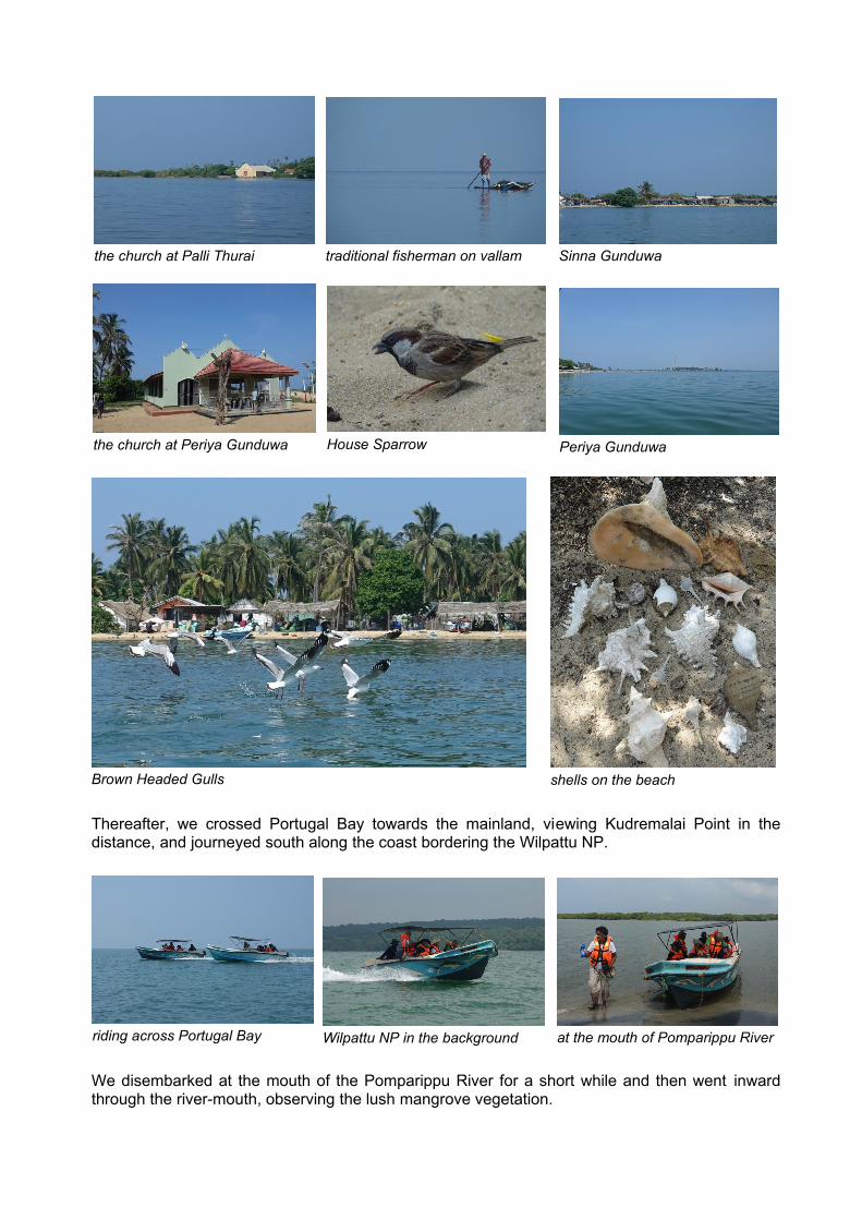
Thereafter, we crossed Portugal Bay towards the mainland, viewing Kudremalai Point in thedistance, and journeyed south along the coast bordering the Wilpattu NP.
We disembarked at the mouth of the Pomparippu River for a short while and then went inwardthrough the river-mouth, observing the lush mangrove vegetation.
traditional fisherman on vallam Sinna Gunduwathe church at Palli Thurai
the church at Periya Gunduwa House Sparrow Periya Gunduwa
Brown Headed Gulls shells on the beach
riding across Portugal Bay Wilpattu NP in the background at the mouth of Pomparippu River

Two Baobab trees close to the river bank were seen. The boatman reached deep into the muddywaters of the river and showed us clumps of oysters, most of which were dead due to thepresence of excess fresh water after the rains. We returned to the bay and continued cruisingalong the coast and reached the Kalpitiya jetty around 1400 hours. No sooner than we were onland, it started to drizzle; with the rain getting more heavier and ending up in a veritablethunderstorm by the time we had reached the safety of the Elite Restaurant for lunch. Thepredicted rainy weather had reached us and so we were confined indoors to take rest at ourabode for the rest of the evening.
We met up in the evening, as usual, for an initial period of camaraderie, followed by dinner. Soended a very eventful day with the visits to the islands being a first for most of us.
19 th November 2018
The day dawned with clear blue skies as we had our early morning tea and biscuits at 0630hours. We drove down to the Dolphin Wadiya and six of us took off by boat at 0730 hours towatch the dolphins. The rest explored the beach and the sand dunes for birds, crustaceans,molluscs and coastal vegetation before heading back for breakfast.
Baobab Tree
Crocodile - is it dead or alive
Bird Island
into the Pomparippu River mangroves with buttress roots aerial roots
Grey HeronPelicandead oyster shells
the Coast Guard checks on usthe Dolphin watchers more Dolphin watchers

DOLPHIN WATCHING
The seafarers were lucky, in that within about 45 mins the Spinner Dolphinswere sighted by our look-out. Thereafter they continued to be within our sightas they dived into the sea, from time to time, to feed and re-surfaced tobreathe. The pods were quite large and in many instances they were quiteclose to our boat and even close enough to be touched. We spent about 1½hours following their movement as they more or less circled about in thesame area. The boatman informed us that the Dolphins were chasing andfeeding on a large shoal of Tuna fish in the vicinity. The fishing boats whichwere also following the dolphins had good luck with their line fishing, whichconfirmed the boatman’s assertion. Having had our fill of dolphin watching,we cruised back to shore at about 1015 hours.
The van with driver, Mahinda, arrived and we went back to our abode to join the rest of ourcomrades. Having joined up we drove into Kalpitiya to visit the interesting sites thereat.
OLD DUTCH FORT
The old Dutch Fort at Kalpitiya, built by the Dutch in 1667, is situatedwithin the Navy encampment and is managed by them. Prior toentering the fort, Enoka obliged by reading relevant excerpts aboutthis fort from the book “The Dutch Forts of Sri Lanka” by WA Nelson.This fort was very important as it controlled the trade that took placevia the Kalpitiya port. By closing the port to shipping, other than to theDutch East Indian Company, the Dutch were able to blockade theKandyan kingdom and secure a monopoly.
the look-out
so close so many all over
up close again still around Tuna catch
Enoka reads....

We were escorted into the premises and walked about the fort exploring its innards. It is a four-sided, four corner bastion type fort, built of coral masonry, 350 feet each way with 20 foot highramparts. The main gateway, with the date 1776 and VOC emblem carved above and the date1760 carved directly on the wooden gate, faces the quay and the jetty as the main aim of the fortwas the protection and maintenance of trade along the water with other ports in the East,including India and the Indian Ocean. The main structures, consisting of a parade ground,barracks, warehouses, ramparts, bastions, 30 gun embrasures and sentry boxes were found tobe in sound condition and were readily discernible. However, we could not explore the magazinesas they were blocked off.
the entrance doorway at the eastern entarnce
an informative display at the entrance
Black Rumped Flamebacks seen outside the Fort
the date 1760 in Roman numerals carved on the wooden door at the eastern entrance
the parade grounds one of four corner guard-houses rampart & storehouses

OLD DUTCH CHURCH
Thereafter we visited the Old Dutch Reformed Church whichwas close by, within the town. The church had beenrenovated with a new roof. The old belfry was located in thewalled churchyard which also contained many monuments.The inscriptions, both in Dutch and English, found on thelarge gravestones on the floor of the church were examinedwith interest.
Thereafter we walked down to Elite Restaurant, which was close by, for lunch. After lunch wedrove back to our abode. Since we had covered all that which we had planned to visit, a decisionwas taken to pack up and leave, cutting short our visit by one day. This move turned out to bewise since evening thundershowers set in a short while after we left.
OTHER INTERESTING SITES
On the way we stopped to visit the ruins of the Alirani Palace,which turned out to be hardly of any interest - in fact wewondered if we were shown something else by the locals. Also amosque at Palliwasala Thurai that bears a unique architecturalstyle, featuring Dutch style verandahs, doors and windows,combined with wooden pillars with Kandyan style pekada,painted in green and orange. This mosque house the tombs oftwo muslim saints. The caretaker kindly obliged us by showingus the insides of the tombs and explaining their significance.
side verandah with monuments in the garden
at Palliwasala Thuraiat Palliwasala Thurai
the renovated church
a gravestone on the church floor
an intricately carved gravestone
the bell tower on the left side
one of the very few remnants of ruins at Alirani Palace
Kandyan Style Pedaka at Palliwasala Thurai

Thereafter we continued our journey back home in the pouring rain, thankful that we had opted toreturn home instead of staying over for a further day. We stopped for tea/coffee and a light dinneralong the way and reached Colombo by about 1900 hours.
IN GENERAL
The weather was mostly hot and sunny but reasonably cool due to the constant strong breeze.The rains started on the second day and we left for home the next afternoon, avoiding the rainyweather. We were able to visit all the places and indulge in all the activities that we had planned.Bird life was sparse due to the high water levels. The negative comments on Karadiya ReachHotel have already been made and we would most certainly not visit this place again in itspresent condition.
Our appreciation to :-
l SLNHS, especially Ninel, for the time and effort spent in organizing the trip and thelogistics
l Chanaka for bringing along the one inch maps of the area and donating same to the NHSl The management and staff of the Karadiya Reach Hotell The boatman, Priyantha, and his team, for taking us safely to and from the islandsl The boatman and the look-out on our dolphin watching expedition (from Dolphin Wadiya)
for their courtesy and competencel Coach driver Mahinda for his careful driving and bringing us home safe and soundl All our participants for their pleasant friendly companionship and camaraderie which
added greatly to an enjoyable trip.
This field visit report was compiled by Sri, supplemented by Enoka, with photographsby Sri. The views expressed are those of the writers and not necessarily those of theSLNHS.