Slide 1 Second GPS/RO Users Workshop, August 22 - 24, 2005. The EUMETSAT Polar System GRAS SAF and...
23
Slide 1 econd GPS/RO Users Workshop, August 22 - 24, 2005. The EUMETSAT Polar System The EUMETSAT Polar System GRAS SAF and Data Products GRAS SAF and Data Products Martin B. Sorensen GRAS SAF Project Atmosphere Space Research Division Danish Meteorological Institute (DMI) Copenhagen
-
Upload
irene-sims -
Category
Documents
-
view
212 -
download
0
Transcript of Slide 1 Second GPS/RO Users Workshop, August 22 - 24, 2005. The EUMETSAT Polar System GRAS SAF and...

Slide 1Second GPS/RO Users Workshop, August 22 - 24, 2005.
The EUMETSAT Polar SystemThe EUMETSAT Polar SystemGRAS SAF and Data ProductsGRAS SAF and Data Products
Martin B. Sorensen
GRAS SAF ProjectAtmosphere Space Research DivisionDanish Meteorological Institute (DMI)
Copenhagen

Slide 2Second GPS/RO Users Workshop, August 22 - 24, 2005.
Outline of presentationOutline of presentation
• Introduction
• EUMETSAT Polar System
• The EUMETSAT Satellite Application Facilities
(the SAF concept)
• GRAS Measurement System
• The GRAS SAF Operational Centre
• GRAS SAF products
• GRAS SAF product dissemination and archives
• Summary

Slide 3Second GPS/RO Users Workshop, August 22 - 24, 2005.
IntroductionIntroduction
• EUMETSAT Polar System (EPS) is the European component of
the joint European/US polar satellite system (IJPS)
• EPS mission consists of three Metop satellites with a payload of
eight meteorological instruments
• The first Metop satellite is launched in second half of 2006
• The total duration of the EPS mission is 14 years
• GRAS receiver has been developed especially for radio
occultation measurements within the EPS framework by ESA
and EUMETSAT
=> NRT products for NWP applications and continuity of radio
occultation data for climate monitoring

Slide 4Second GPS/RO Users Workshop, August 22 - 24, 2005.
Initial Joint Polar SystemInitial Joint Polar System
NOAA N & N’ p.m.
METOP 1 & 2 a.m.
Global datadump
Global datadump
NOAA GSEPS GS
NOAA global dataMETOP blind orbits
METOP global dataNOAA blind orbits
Blind orbitsdata dump
SAF
SAF
EUMETSAT POLAR SYSTEMNOAA POES SYSTEM
SAF
SAF
SAF
SAF

Slide 5Second GPS/RO Users Workshop, August 22 - 24, 2005.
GRAS receiverGRAS receiver
• 12 bi-frequency channels
• Codeless-mode capability
• Oven stabilised USO (Allan deviation 10-12)
• Directional high gain occultation antennas for minimising local multipath
• Onboard DSP => autonomous operations
506 mm
860
mm
47 m m

Slide 6Second GPS/RO Users Workshop, August 22 - 24, 2005.
The EUMETSAT Satellite Application Facilities The EUMETSAT Satellite Application Facilities
The SAF conceptThe SAF concept

Slide 7Second GPS/RO Users Workshop, August 22 - 24, 2005.
MSG
EPS/Metop
Applications Ground Segment
Centralisedprocessingand generationof products
Decentralisedprocessingand generationof products
Data Acquisitionand Control
Data ProcessingEUMETSAT HQ
Meteorological ProductsExtraction Facility (MPEF)
EUMETSAT HQ
Unified MeteorologicalArchive & RetrievalFacility (U-MARF)EUMETSAT HQ
GRAS SAF
Satellite ApplicationFacilities (SAFs)
USERS
Distributed Ground SegmentDistributed Ground Segment

Slide 8Second GPS/RO Users Workshop, August 22 - 24, 2005.
GRAS SAF Overview and PlansGRAS SAF Overview and Plans
• GRAS Satellite Application Facility (SAF) started in 1999– Operational facility for atmosphere products from GRAS instrument on
Metop (Launch planned 2006)– 7 year developments
• Partner Institutes– Danish Meteorological Institute (Host institute)
– K.B. Lauritsen, M.B. Sørensen, F. Rubek– Met Office, UK
– D. Offiler, Axel v. Engeln, C. Marquardt, (S. Healy)– Institut d’Estudis Espacials de Catalunya (IEEC), Spain
– A. Rius, S. Oliveras• Milestones
– 2004 System test and verification– 2005 Integration test– 2006 Commissioning of Metop – 2007 Operational products from GRAS SAF

Slide 9Second GPS/RO Users Workshop, August 22 - 24, 2005.
The GRAS measurement systemThe GRAS measurement system

Slide 10Second GPS/RO Users Workshop, August 22 - 24, 2005.
NRT ChallengeNRT Challenge
• EPS GRAS is the first RO mission that has been from the beginning designed for operational applications
• NRT requirements for GRAS product dissemination are 2 h 15 min for level 1b and 3 h for level 2 from the observation
• Analysis of the NRT feasibility has revealed two main risks:– Timely availability of the auxiliary data– NRT Precise Orbit Determination of the LEO satellite
• Mitigation of these risks is incorporated in the GRAS Measurement System design
• There has been no reason to compromise the occultation data processing due to the NRT requirements

Slide 11Second GPS/RO Users Workshop, August 22 - 24, 2005.
GRAS Measurement SystemGRAS Measurement SystemM etop
EPS Polar s ite
EU M ETSATEPS C G S
U SER S
G R ASM eteorology SAF
hosted by D M ILevel 2 products
Level 1b products
G PS systemO ccultation &
navigation
Tracking
G R AS G SN Service
• GRAS Ground Support Network (GSN) provides GPS POD products and ground based measurements
• Level 1b products are processed and disseminated by the EPS Core Ground Segment (CGS)
• Level 2 products are processed and disseminated by the GRAS Meteorology SAF
• Archived products include raw data, level 1b, level 2 and all GSN products
• Off-line user access to archived products via EUMETSAT UMARF

Slide 12Second GPS/RO Users Workshop, August 22 - 24, 2005.
GRAS Ground Support Network (GSN)GRAS Ground Support Network (GSN)
• GRAS GSN is a service to provide GPS state vectors, clock
offset estimates, and clock differencing data for GRAS data
processing
• GSN will contain a network of 25 fiducial stations
• GSN coverage for the GPS constellation is > 200 % to ensure
service availability via redundancy
• The GSN Service is designed to support the GRAS NRT data
processing requirements

Slide 13Second GPS/RO Users Workshop, August 22 - 24, 2005.
GPS Satellite Visibility GPS Satellite Visibility

Slide 14Second GPS/RO Users Workshop, August 22 - 24, 2005.
The GRAS SAF operational processing centreThe GRAS SAF operational processing centre

Slide 15Second GPS/RO Users Workshop, August 22 - 24, 2005.
GRAS SAF Operationel SystemGRAS SAF Operationel System
G S N
RMDCN / GTS(EUMETCast?)
GRAS SAF productsin NRT to users
Task Manager & User facilities
Satellite dish
FTP/HTTP Server
GTS Interface
Data switch
Firewall
Router
Firewall
Router
Firewall
UMARF Client
Internet
RMDCN
Receiving GRASLevel1B data fromEUMETSAT CGS
Processor #1 Processor #2Data Retriever
Nominalprocessing
chain
Backlog &Reproces-sing chain
GSN
Data Retriever
Off-Line Processorbackup
Off-Line Processor
NRT Processorbackup
NRT Processor
ECMW F
DMI GRIB DB
GRAS SAFLocal Archive
DMI Central Archive
EUMETCAST Term inal Backup
EUMETCAST Term inal
DVB Router
DVB Router Backup
EUMETSAT
ECMW F
USERS
UMARF
EPS

Slide 16Second GPS/RO Users Workshop, August 22 - 24, 2005.
EUMETCast coverageEUMETCast coverage

Slide 17Second GPS/RO Users Workshop, August 22 - 24, 2005.
The GRAS SAF ProductsThe GRAS SAF Products

Slide 18Second GPS/RO Users Workshop, August 22 - 24, 2005.
Data and software products from Data and software products from the GRAS SAFthe GRAS SAF
• Data products (Level 2) in NRT (3 hrs)– Refractivity, Temperature, Pressure and
Humidity profiles– Surface pressure
• Data products Offline– Reprocessed level 2 products – Bending angle (Level 1)
• ROP Package– 3/4DVAR Assimilation Software– Pre-processing tools – Forward operators– Error covariance matrix
DMI processing center
Met Office

Slide 19Second GPS/RO Users Workshop, August 22 - 24, 2005.
The GRAS data distribution & archivesThe GRAS data distribution & archives

Slide 20Second GPS/RO Users Workshop, August 22 - 24, 2005.
NRT Dissemination via RMDCNNRT Dissemination via RMDCNEUMETCast ?EUMETCast ?
Viln iusC o p e nh a g e n
Zü ric h
Ta llin
Rig a
EC M WF
He lsinki
Re ykja vik
Anka raRe yka vikAthe ns
Re yka vikBud a p e st
Ljub ja na
Re yka vikO ffe nb a c h
Re yka vikZuric h
Re yka viVie nna
Re yka vikC o p e nha g e n
No rd kö p ing
Re yka vikHe lsinkiO slo
EC M WF
Ro m e
Re yka vikM a d rid
Re yka vikLisb o n
Re yka vikTo ulo use
Brusse ls
De Bit
Za g re b
Re yka vikRe ykja vik
Re yka vikDub lin
Regional Meteorological Data Communication Network for ECMWF and WMO Region VI

Slide 21Second GPS/RO Users Workshop, August 22 - 24, 2005.
Off-line and reprocessed data via UMARF Off-line and reprocessed data via UMARF - or from the local GRAS SAF archive- or from the local GRAS SAF archive
Unified Meteorological Archive and Retrieval Facility Unified Meteorological Archive and Retrieval Facility
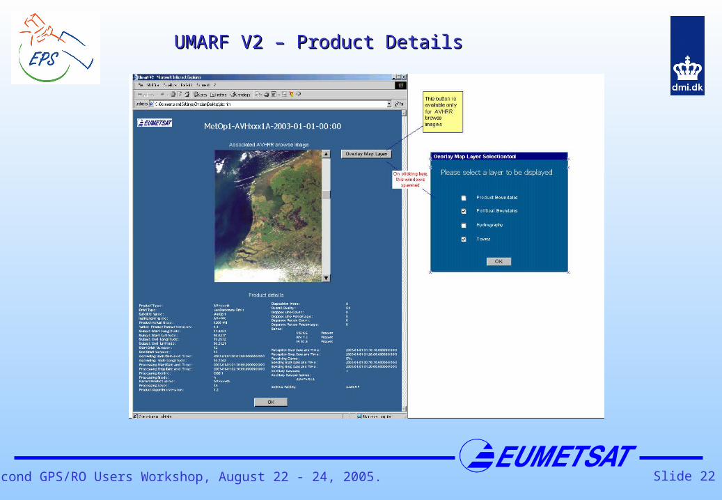
Slide 22Second GPS/RO Users Workshop, August 22 - 24, 2005.
UMARF V2 – Product DetailsUMARF V2 – Product Details

Slide 23Second GPS/RO Users Workshop, August 22 - 24, 2005.
SummarySummary• The objective of the EPS GRAS mission is to provide NWP users
operationally radio occultation data products
• The EPS mission starts in 2006 and provides data continuously at least for 14 years
• GRAS data processing and dissemination are performed by the EPS CGS (level 1b ) and by the GRAS Meteorology SAF (level 2 )
• All archived GRAS products (level 0, level 1b, and level 2) shall be made available via the EUMETSAT UMARF facility
• Analysis and study results indicate that the NRT data processing with the required accuracy is feasible for about 92 % of the observations
www.eumetsat.int & http://grassaf.dmi.dkwww.eumetsat.int & http://grassaf.dmi.dk


![GRAS SAF CDOP - ROM SAF · 18/04/2008 · 1. Introduction The purpose of this study was to use data from the German CHAMP (CHAllenging Minisatel-lite Payload, Reigber et al. [2005]](https://static.fdocuments.in/doc/165x107/5f3dba986e6a3e29d42628e5/gras-saf-cdop-rom-saf-18042008-1-introduction-the-purpose-of-this-study.jpg)