SLIC SUPERPIXELS FOR OBJECT DELINEATION FROM … · structures in the image are conserved (Neubert...
8
SLIC SUPERPIXELS FOR OBJECT DELINEATION FROM UAV DATA S. Crommelinck a,* , R. Bennett b , M. Gerke c , M. N. Koeva a , M. Y. Yang a , G. Vosselman a a Faculty of Geo-Information Science and Earth Observation (ITC), University of Twente, Enschede, the Netherlands – (s.crommelinck, m.n.koeva, michael.yang, george.vosselman)@utwente.nl b Faculty of Business and Law, Swinburne University of Technology, Victoria, Australia – [email protected] c Institute of Geodesy und Photogrammetry, Technical University of Brunswick, Brunswick, Germany – [email protected] ICWG I/II KEY WORDS: UAV Photogrammetry, Image Segmentation, Object Detection, Contour Detection, Image Analysis, Land Administration, Cadastral Boundaries, Cadastral Mapping ABSTRACT: Unmanned aerial vehicles (UAV) are increasingly investigated with regard to their potential to create and update (cadastral) maps. UAVs provide a flexible and low-cost platform for high-resolution data, from which object outlines can be accurately delineated. This delineation could be automated with image analysis methods to improve existing mapping procedures that are cost, time and labor intensive and of little reproducibility. This study investigates a superpixel approach, namely simple linear iterative clustering (SLIC), in terms of its applicability to UAV data. The approach is investigated in terms of its applicability to high-resolution UAV orthoimages and in terms of its ability to delineate object outlines of roads and roofs. Results show that the approach is applicable to UAV orthoimages of 0.05 m GSD and extents of 100 million and 400 million pixels. Further, the approach delineates the objects with the high accuracy provided by the UAV orthoimages at completeness rates of up to 64%. The approach is not suitable as a standalone approach for object delineation. However, it shows high potential for a combination with further methods that delineate objects at higher correctness rates in exchange of a lower localization quality. This study provides a basis for future work that will focus on the incorporation of multiple methods for an interactive, comprehensive and accurate object delineation from UAV data. This aims to support numerous application fields such as topographic and cadastral mapping. 1. INTRODUCTION Superpixel approaches, introduced in (Ren and Malik, 2003), group pixels into perceptually meaningful atomic regions. Superpixels are located between pixel- and object-level: they carry more information than pixels by representing perceptually meaningful pixel groups, while not comprehensively representing image objects. Superpixels can be understood as a form of image segmentation, that oversegment the image in a short computing time. Comparisons to similar approaches that can be found in (Achanta et al., 2012; Csillik, 2016; Neubert and Protzel, 2012; Schick et al., 2012; Stutz, 2015; Stutz et al., 2017) have demonstrated their advantages: The outlines of superpixels have shown to adhere well to natural image boundaries, as most structures in the image are conserved (Neubert and Protzel, 2012; Ren and Malik, 2003). Furthermore, they allow to reduce the susceptibility to noise and outliers as well as to capture redundancy in images. With image features being computed for each superpixel rather than each pixel, subsequent processing tasks are reduced in complexity and computing time. Thus, superpixels are considered useful as a preprocessing step for analyses at object level such as image segmentation (Achanta et al., 2012; Achanta et al., 2010). In general, the success of image segmentation activities is highly variable as it depends on the image, the algorithm and its parameters: an algorithm that performs as desired on one image might result in a lower segmentation quality when applied with the same parameters to another image. This study investigates the applicability of a superpixel approach, namely simple linear iterative clustering (SLIC), in terms of its ability to delineate object outlines of roads and roofs from UAV data. The approach has proven to accurately delineate object outlines (Achanta et al., * Corresponding author 2012). In this study, SLIC is applied on two UAV orthoimages of 0.05 m GSD and extents of 100 million and 400 million pixels. Object delineation is potentially useful in numerous application fields, such as topographic and cadastral mapping (Crommelinck et al., 2016). Cadastral mapping refers to mapping the extent, value and ownership of land, being crucial for a continuous and sustainable recording of land rights (Williamson et al., 2010). Cadastral mapping is used in this study as an example application field to investigate the applicability of SLIC superpixels for an automatic delineation of object outlines. Such visible outlines can correspond to cadastral boundaries, as a large portion of cadastral boundaries are assumed to be visible (Zevenbergen and Bennett, 2015). Automatically delineating visible boundaries, would thus improve cadastral mapping approaches in terms of cost, time, accuracy and reproducibility. This study investigates SLIC superpixels as part of a boundary delineation workflow. It does not provide a full workflow for automatic delineation of visible cadastral boundaries. However, when used alongside other more conventional mapping techniques, the approach may improve the time and costs associated with wide-area cadastral mapping projects. 2. RELATED WORK 2.1 Superpixel Approaches Superpixels oversegment an image by forming compact and uniform groups of pixels that have similar characteristics in e.g., color or geometry. In the past, multiple superpixel approaches have been developed. They can be classified into i) graph-based and ii) gradient-ascent-based approaches: ISPRS Annals of the Photogrammetry, Remote Sensing and Spatial Information Sciences, Volume IV-2/W3, 2017 International Conference on Unmanned Aerial Vehicles in Geomatics, 4–7 September 2017, Bonn, Germany This contribution has been peer-reviewed. The double-blind peer-review was conducted on the basis of the full paper. doi:10.5194/isprs-annals-IV-2-W3-9-2017 | © Authors 2017. CC BY 4.0 License. 9
Transcript of SLIC SUPERPIXELS FOR OBJECT DELINEATION FROM … · structures in the image are conserved (Neubert...

SLIC SUPERPIXELS FOR OBJECT DELINEATION FROM UAV DATA
S. Crommelinck a,*, R. Bennett b, M. Gerke c, M. N. Koeva a, M. Y. Yang a, G. Vosselman a
a Faculty of Geo-Information Science and Earth Observation (ITC), University of Twente, Enschede, the Netherlands –
(s.crommelinck, m.n.koeva, michael.yang, george.vosselman)@utwente.nl b Faculty of Business and Law, Swinburne University of Technology, Victoria, Australia – [email protected]
c Institute of Geodesy und Photogrammetry, Technical University of Brunswick, Brunswick, Germany – [email protected]
ICWG I/II
KEY WORDS: UAV Photogrammetry, Image Segmentation, Object Detection, Contour Detection, Image Analysis, Land
Administration, Cadastral Boundaries, Cadastral Mapping
ABSTRACT:
Unmanned aerial vehicles (UAV) are increasingly investigated with regard to their potential to create and update (cadastral) maps.
UAVs provide a flexible and low-cost platform for high-resolution data, from which object outlines can be accurately delineated. This
delineation could be automated with image analysis methods to improve existing mapping procedures that are cost, time and labor
intensive and of little reproducibility. This study investigates a superpixel approach, namely simple linear iterative clustering (SLIC),
in terms of its applicability to UAV data. The approach is investigated in terms of its applicability to high-resolution UAV orthoimages
and in terms of its ability to delineate object outlines of roads and roofs. Results show that the approach is applicable to UAV
orthoimages of 0.05 m GSD and extents of 100 million and 400 million pixels. Further, the approach delineates the objects with the
high accuracy provided by the UAV orthoimages at completeness rates of up to 64%. The approach is not suitable as a standalone
approach for object delineation. However, it shows high potential for a combination with further methods that delineate objects at
higher correctness rates in exchange of a lower localization quality. This study provides a basis for future work that will focus on the
incorporation of multiple methods for an interactive, comprehensive and accurate object delineation from UAV data. This aims to
support numerous application fields such as topographic and cadastral mapping.
1. INTRODUCTION
Superpixel approaches, introduced in (Ren and Malik, 2003),
group pixels into perceptually meaningful atomic regions.
Superpixels are located between pixel- and object-level: they
carry more information than pixels by representing perceptually
meaningful pixel groups, while not comprehensively
representing image objects. Superpixels can be understood as a
form of image segmentation, that oversegment the image in a
short computing time. Comparisons to similar approaches that
can be found in (Achanta et al., 2012; Csillik, 2016; Neubert and
Protzel, 2012; Schick et al., 2012; Stutz, 2015; Stutz et al., 2017)
have demonstrated their advantages: The outlines of superpixels
have shown to adhere well to natural image boundaries, as most
structures in the image are conserved (Neubert and Protzel, 2012;
Ren and Malik, 2003). Furthermore, they allow to reduce the
susceptibility to noise and outliers as well as to capture
redundancy in images. With image features being computed for
each superpixel rather than each pixel, subsequent processing
tasks are reduced in complexity and computing time. Thus,
superpixels are considered useful as a preprocessing step for
analyses at object level such as image segmentation (Achanta et
al., 2012; Achanta et al., 2010).
In general, the success of image segmentation activities is highly
variable as it depends on the image, the algorithm and its
parameters: an algorithm that performs as desired on one image
might result in a lower segmentation quality when applied with
the same parameters to another image. This study investigates the
applicability of a superpixel approach, namely simple linear
iterative clustering (SLIC), in terms of its ability to delineate
object outlines of roads and roofs from UAV data. The approach
has proven to accurately delineate object outlines (Achanta et al.,
* Corresponding author
2012). In this study, SLIC is applied on two UAV orthoimages
of 0.05 m GSD and extents of 100 million and 400 million pixels.
Object delineation is potentially useful in numerous application
fields, such as topographic and cadastral mapping (Crommelinck
et al., 2016). Cadastral mapping refers to mapping the extent,
value and ownership of land, being crucial for a continuous and
sustainable recording of land rights (Williamson et al., 2010).
Cadastral mapping is used in this study as an example application
field to investigate the applicability of SLIC superpixels for an
automatic delineation of object outlines. Such visible outlines can
correspond to cadastral boundaries, as a large portion of cadastral
boundaries are assumed to be visible (Zevenbergen and Bennett,
2015). Automatically delineating visible boundaries, would thus
improve cadastral mapping approaches in terms of cost, time,
accuracy and reproducibility. This study investigates SLIC
superpixels as part of a boundary delineation workflow. It does
not provide a full workflow for automatic delineation of visible
cadastral boundaries. However, when used alongside other more
conventional mapping techniques, the approach may improve the
time and costs associated with wide-area cadastral mapping
projects.
2. RELATED WORK
2.1 Superpixel Approaches
Superpixels oversegment an image by forming compact and
uniform groups of pixels that have similar characteristics in e.g.,
color or geometry. In the past, multiple superpixel approaches
have been developed. They can be classified into i) graph-based
and ii) gradient-ascent-based approaches:
ISPRS Annals of the Photogrammetry, Remote Sensing and Spatial Information Sciences, Volume IV-2/W3, 2017 International Conference on Unmanned Aerial Vehicles in Geomatics, 4–7 September 2017, Bonn, Germany
This contribution has been peer-reviewed. The double-blind peer-review was conducted on the basis of the full paper. doi:10.5194/isprs-annals-IV-2-W3-9-2017 | © Authors 2017. CC BY 4.0 License. 9
In i), each pixel is considered a node in a graph. An edge
weight is defined between all pairs of nodes that is
proportional to their similarity. Then, a cost function defined
on the graph is formulated and minimized, in order to extract
superpixel segments. Examples of graph-based approaches
are (Felzenszwalb and Huttenlocher, 2004; Moore et al.,
2008; Shi and Malik, 2000).
In ii), pixels are iteratively mapped to a feature space to
delineate denser regions that represent clusters. Each
iteration refines each cluster to obtain a better segmentation
until convergence. Examples of gradient-ascent-based
approaches are (Comaniciu and Meer, 2002; Levinshtein et
al., 2009; Vincent and Soille, 1991).
State-of-the-art superpixel approaches have been compared in
(Achanta et al., 2012; Csillik, 2016; Neubert and Protzel, 2012;
Schick et al., 2012; Stutz, 2015; Stutz et al., 2017) considering
speed, memory efficiency, compactness of outlines, their ability
to adhere to image boundaries and their impact on segmentation
performance. Boundary adherence is often measured via
boundary recall, indicating how many true edges are missed, and
via undersegmentation, indicating to what extent superpixels
exceed outlines of the reference data (Achanta et al., 2012;
Neubert and Protzel, 2012). The SLIC superpixel approach,
belonging to the group of gradient-ascent-based approaches,
appears as the best overall performer: the algorithm is low in
processing time and produces compact and nearly uniform
superpixels that are positively evaluated in terms of boundary
recall and undersegmentation error (Achanta et al., 2012; Csillik,
2016; Neubert and Protzel, 2012; Schick et al., 2012; Stutz, 2015;
Stutz et al., 2017).
2.2 SLIC Approach
SLIC was introduced in (Achanta et al., 2010) and later extended
to a zero parameter version of SLIC called SLICO and compared
to state-of-the-art superpixel approaches in (Achanta et al.,
2012). SLIC considers image pixels in a 5D space, defined by the
L*a*b values of the CIELAB color space as well as their x and y
coordinates. Pixels in the 5D space are clustered based on an
adapted k-means clustering integrating color similarity and
proximity in the image plane. The clustering is based on a
distance measure D that measures color similarity in L*a*b space
(𝑑𝑐) and pixel proximity in x, y space (𝑑𝑠). The latter is
normalized by a grid interval (S) that defines the square root of
the total number of image pixels divided by the number of
superpixels (k). The compactness and regularity of the
superpixels is controlled with the constant m. This parameter
functions as a weighting criteria between the spatial distance (𝑑𝑐)
and the spectral distance (𝑑𝑠). A larger m, increases the weight
of spatial proximity, which leads to more compact superpixels
with boundaries adhering less to spectral outlines in the image.
D = √(𝑑𝑐
𝑚)
2+ (
𝑑𝑠
𝑆)
2
(1)
SLICO replaces the constant values for m and S used in (1) to
normalize spectral and spatial proximity, by iteratively
normalizing their proximity. The proximities are dynamically
normalized for each cluster considering the maximum observed
spectral distance (𝑚𝑐) and spatial distance (𝑚𝑠) from the
previous iteration. This leads to a more consistent superpixel
compactness and a reduced need to define parameters.
D = √(𝑑𝑐
𝑚𝑐)
2+ (
𝑑𝑠
𝑚𝑠)
2 (2)
In general, only pixels within D are considered during clustering,
which makes SLIC fast and computational efficient compared to
conventional k-means clustering. Another advantage of SLIC is
its ability to be applied to images greater than 0.5 million pixels,
Processing time scales linearly with the number of pixels.
Further, it is simple to implement and demands low
computational and memory cost. Its boundary recall is lowest
compared to other approaches. However, the risk of losing
meaningful image edges remains, when an edge is placed inside
a superpixel (Achanta et al., 2012).
SLIC implementations are available in OpenCV (Bradski, 2016),
VLFeat (Vedaldi, 2013), GDAL (Balint, 2016), Scikit (Scikit-
Learn Developers, 2012), Matlab (MathWorks, 2016) and
GRASS (Kanavath and Metz, 2017). They are mostly based on
the two SLIC versions proposed in (Achanta et al., 2012). For the
first version (SLIC), the parameter k specifies the number of
approximately equally sized superpixels. Optionally, the
compactness parameter m can be set to control the trade-off
between superpixels’ homogeneity and boundary adherence.
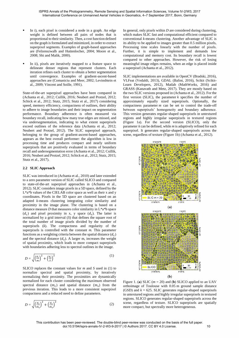
This version generates regular-shaped superpixels in untextured
regions and highly irregular superpixels in textured regions
(Figure 1a). For the second version (SLICO), only the
parameter k can be defined, while m is adaptively refined for each
superpixel. It generates regular-shaped superpixels across the
scene, regardless of texture (Figure 1b) (Achanta et al., 2012).
(a)
(b)
Figure 1. (a) SLIC (m = 20) and (b) SLICO applied to an UAV
orthoimage of Toulouse with 0.05 m ground sample distance
(GSD) and k = 625. SLIC generates regular-shaped superpixels
in untextured regions and highly irregular superpixels in textured
regions. SLICO generates regular-shaped superpixels across the
scene, regardless of texture. SLICO superpixels are spatially
more compact, but spectrally more heterogeneous.
ISPRS Annals of the Photogrammetry, Remote Sensing and Spatial Information Sciences, Volume IV-2/W3, 2017 International Conference on Unmanned Aerial Vehicles in Geomatics, 4–7 September 2017, Bonn, Germany
This contribution has been peer-reviewed. The double-blind peer-review was conducted on the basis of the full paper. doi:10.5194/isprs-annals-IV-2-W3-9-2017 | © Authors 2017. CC BY 4.0 License.
10
2.3 Superpixels in Remote Sensing
The benefits of analyzing groups of pixels instead of single
pixels, has been verified from a computer vision perspective for
multiple applications such as object recognition (Malisiewicz and
Efros, 2007; Pantofaru et al., 2008). This has similarly been done
from a remote sensing perspective for object-based image
analysis (OBIA) (Blaschke, 2010). The use of superpixels in
computer vision is increasingly popular, whereas only few
studies in remote sensing consider superpixels (Acuña et al.,
2016; Chen et al., 2016; Csillik, 2016; Ortiz Toro et al., 2015;
Sahli et al., 2012; Thompson et al., 2010; Vargas et al., 2015;
Zhang et al., 2015).
However, the need and acceptance of superpixels in remote
sensing is presumed: the local spatial autocorrelation between
pixels with a high resolution in remotely sensed imagery is high.
Thus one object is often composed of many pixels with similar
characteristics (Chen et al., 2012). This has led to the formulation
of the OBIA paradigm (Blaschke, 2010). Superpixels that group
pixels of similar characteristics into an oversegmented image are
considered a preprocessing step in conventional OBIA
approaches (Zhang et al., 2015).
A comparison of four state-of-the-art superpixel approaches,
with SLIC being the best choice considering speed and accuracy,
has been conducted on satellite imagery of 0.5 - 0.6 m GSD and
an extent of 4 million pixels (Csillik, 2016). In further studies that
apply superpixels on remote sensing data, SLIC is equally
considered as the most suitable superpixel approach (Csilik and
Lang, 2016; Ortiz Toro et al., 2015; Sahli et al., 2012; Vargas et
al., 2015). SLIC has rarely been applied to UAV data, or for
object delineation in topographic or cadastral mapping. This
study aims to bridge both of these research gaps.
2.4 SLIC Superpixels for Object Delineation
In general, SLIC cannot be considered as a standalone approach
for object delineation. Each superpixel needs to be closed even if
no object outline is available within the image. The larger k, the
more outlines are generated that do not align with object outlines.
In order to eliminate those unwanted outlines, SLIC could be
combined with further segmentation methods. Another option,
proposed in (Sahli et al., 2012) would be to fuse neighboring
SLIC regions of similar color to eliminate non-relevant outlines.
Combining the information from multiple segmentations has
been investigated in other studies aiming to develop a
transferable approach with a constant object recognition
robustness and a reduced need for parameter optimization. Object
outlines delineated through multiple segmentations are shown to
be more reliable and robust compared to those detected by fewer
segmentations (Borenstein and Ullman, 2008; Malisiewicz and
Efros, 2007; Pantofaru et al., 2008; Russell et al., 2006). This idea
can equally be transferred to superpixels: combining superpixels
with the output of a contour detector has shown to better delineate
object contours, compared to using a standalone superpixel
approach (Levinshtein et al., 2010, 2012; Levinshtein et al., 2009;
Yang and Rosenhahn, 2016).
SLIC superpixels are often combined with the Pb (Martin et al.,
2004) or the gPb (Maire et al., 2008) contour detector. These
approaches combine texture, color and brightness to calculate
probabilities of boundaries (Pb) and globalized probabilities of
boundaries (gPb), respectively. The former considers these cues
on a local scale, while the latter considers them on both a local
and a global scale. Detected contours and superpixel outlines are
mostly combined with cost functions that minimize the inter-
class similarity while maximizing the intra-class similarity. The
functions are optimized through learning based on computer
vision benchmark datasets (Levinshtein et al., 2010, 2012; Yang
and Rosenhahn, 2016). These functions are not directly
transferable to remote sensing imagery, which have more
complex characteristics. However, the approach of gPb contour
detection has been investigated as a standalone approach for
UAV-based cadastral mapping in (Crommelinck et al., 2017).
The study shows that the approach provides a comprehensive
initial detection of candidate objects that could be verified and
located exactly by integrating SLIC outlines.
When combining SLIC and a further segmentation approach,
such as gPb contour detection, moderate errors of omission are
acceptable: outlines missed by SLIC might be detected by the
second approach. In general, a low error of omission, i.e., a high
level of completeness, is of utmost importance for an automated
object detection system before integrating user interaction and
thus reducing the system’s automation (Mayer, 2008). The user
interaction required to manually delineate a missed boundary
(error of omission) is more time-consuming than to delete an
erroneously included boundary (error of commission). The goal
is to minimize the summated time for editing both the error of
omission and commission.
3. MATERIALS AND METHODS
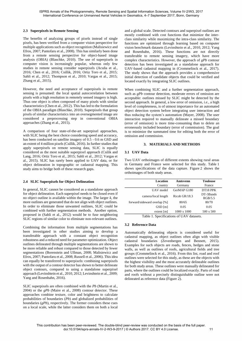
3.1 UAV Data
Two UAV orthoimages of different extents showing rural areas
in Germany and France were selected for this study. Table 1
shows specifications of the data capture. Figure 2 shows the
orthoimages of both study areas.
Location Amtsvenn Toulouse
Country Germany France
UAV model GerMAP G180 DT18 PPK
camera/focal length Ricoh GR/18.3 DT-3Bands
RGB/5.5
forward/sideward overlap [%] 80/65 80/70
GSD [m] 0.05 0.05
extent [m] 1000 x 1000 500 x 500
Table 1. Specifications of UAV datasets.
3.2 Reference Data
Automatically delineating objects is considered useful for
cadastral mapping, as object outlines often align with visible
cadastral boundaries (Zevenbergen and Bennett, 2015).
Examples for such objects are roads, fences, hedges and stone
walls, as well as outlines of roofs, agricultural fields and tree
groups (Crommelinck et al., 2016). From this list, road and roof
outlines were selected for this study, as these are the objects with
the highest visibility and the most accurately delineable outlines
for both study areas. These outlines were manually delineated for
parts, where the outlines could be localized exactly. Parts of road
and roofs without a precisely distinguishable outline were not
delineated as reference data (Figure 2).
ISPRS Annals of the Photogrammetry, Remote Sensing and Spatial Information Sciences, Volume IV-2/W3, 2017 International Conference on Unmanned Aerial Vehicles in Geomatics, 4–7 September 2017, Bonn, Germany
This contribution has been peer-reviewed. The double-blind peer-review was conducted on the basis of the full paper. doi:10.5194/isprs-annals-IV-2-W3-9-2017 | © Authors 2017. CC BY 4.0 License.
11
(a)
(b)
Figure 2. Manually delineated outlines of exactly localizable
roads and roofs used for the accuracy assessment overlaid on
UAV orthoimages of (a) Amtsvenn in Germany and
(b) Toulouse in France. Outlines in close spatial proximity, such
as two parallel outlines of roads, might appear as a thicker line,
as they consist of two parallel lines in the reference data.
3.3 Image Processing Workflow
The image processing workflow consists of the application of
SLIC on the UAV datasets (Section 3.3.1) and its accuracy
assessment (Section 3.3.2). For the SLIC application, a Matlab
implementation was used (MathWorks, 2016), which is based on
(Achanta et al., 2012). All further workflow steps were
implemented in Python as QGIS processing scripts making use
of functionalities from QGIS (QGIS Development Team, 2009),
GRASS (GRASS Development Team, 2015) and GDAL (GDAL
Development Team, 2016).
3.3.1 SLIC Application: The Matlab implementation, used in
this study, provides a SLIC and a SLICO version (MathWorks,
2016). SLICO requires a predefined number of superpixels k,
while SLIC requires k, as well as a compactness parameter m that
regularized the SLIC outlines. k was chosen in accordance to
possible sizes of objects of interest in range [1; 400] m2. m was
chosen in accordance to recommendations from MathWorks in
range [1; 20]. Due to the different extents of the two UAV
orthoimages (Table 1), this resulted in different numbers for k
ranging from 625 to 1,000,000: the smaller the size of one
superpixels, the larger the total number of superpixels k
(Table 2). SLIC was applied to the entire orthoimage.
GSD per
superpixel [m]
Coverage per
superpixel [m2]
k
Amtsvenn
k
Toulouse
1 1 1,000,000 250,000
2 4 250,000 62,500 3 9 111,111 27,778
4 16 62,500 15,625
5 25 40,000 10,000 10 100 10,000 2,500
15 225 4,444 1,111
20 400 2,500 625
Table 2. Varying numbers of superpixels k resulting for the two
study areas with a coverage of 1,000,000 m2 (Amtsvenn) and
250,000 m2 (Toulouse).
3.3.2 Accuracy Assessment: In order to decrease the
processing time of the accuracy assessment, the SLIC outlines
were clipped to a buffer of 0.3 m radius around the reference data.
Then, all lines in the reference data and the clipped SLIC outlines
were buffered with a radius of 0.1 m. These datasets were
converted to a raster format of 0.05 m pixel size. Then, each
SLIC dataset was overlaid with the reference data, in order to
label each pixel as true positive (TP), true negative (TN), false
positive (FP) or false negative (FN). The sum of pixels with an
identical label was summarized in a confusion matrix. From the
confusion matrix, the error of omission (3) and the error of
commission (4) was calculated in range [0; 100]:
𝑒𝑟𝑟𝑜𝑟 𝑜𝑓 𝑜𝑚𝑖𝑠𝑠𝑖𝑜𝑛 [%] = FN
FN + TP ∗ 100 (3)
𝑒𝑟𝑟𝑜𝑟 𝑜𝑓 𝑐𝑜𝑚𝑚𝑖𝑠𝑠𝑖𝑜𝑛 [%] = FP
FP + TP ∗ 100 (4)
The error of omission captures the percentage of pixels
erroneously labelled as ‘no outline’, i.e., the percentage of object
outlines that are missed by the SLIC outlines. The error of
commission captures the percentage of pixels erroneously
labeled as ‘outline’, i.e., the percentage of object outlies that are
incorrectly included in the SLIC outlines. These measures are
based on (Goodchild and Hunter, 1997) and evaluate to which
extent SLIC outlines coincide with actual object outlines.
ISPRS Annals of the Photogrammetry, Remote Sensing and Spatial Information Sciences, Volume IV-2/W3, 2017 International Conference on Unmanned Aerial Vehicles in Geomatics, 4–7 September 2017, Bonn, Germany
This contribution has been peer-reviewed. The double-blind peer-review was conducted on the basis of the full paper. doi:10.5194/isprs-annals-IV-2-W3-9-2017 | © Authors 2017. CC BY 4.0 License.
12
4. RESULTS
(a) (b)
(c) (d)
(e) (f)
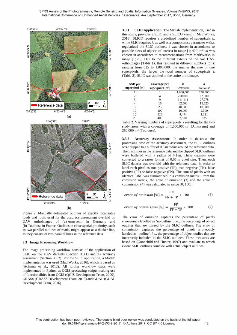
Figure 3. SLIC outlines derived for compactness parameters
(a, b) m = 1, (c, d) m = 20, and (e, f) SLICO, where m is
adaptively refined for each superpixel. The first row of images
shows superpixels overlaid on the orthoimage of Amtsvenn,
while the second row shows superpixels overlaid on the
orthoimage of Toulouse, both for k = 10,000.
Figure 3 shows that the regularity of the superpixel outlines can
be enlarged by increasing m: the outlines of SLIC are more
irregular for m = 1 (Figure 3a,b) than for m = 20 (Figure 3c,d).
They run strictly along boundaries of spectral differences for
m = 1, while m = 20 allows SLIC superpixels that are more
homogeneous in shape, but less homogeneous in spectral content.
This regularity in shape is increased even more, when using
SLICO, for which m is automatically defined (Figure 3e,f). The
superpixels’ outlines require further merging steps to delineate
objects in the image as closed polygons, which will be
investigated in future work. One approach might be to group
SLIC superpixels of similar color. Another approach would be to
merge SLIC outlines at locations, where another method with a
higher detection quality, such as gPb contour detection, locates a
boundary.
(a)
(b)
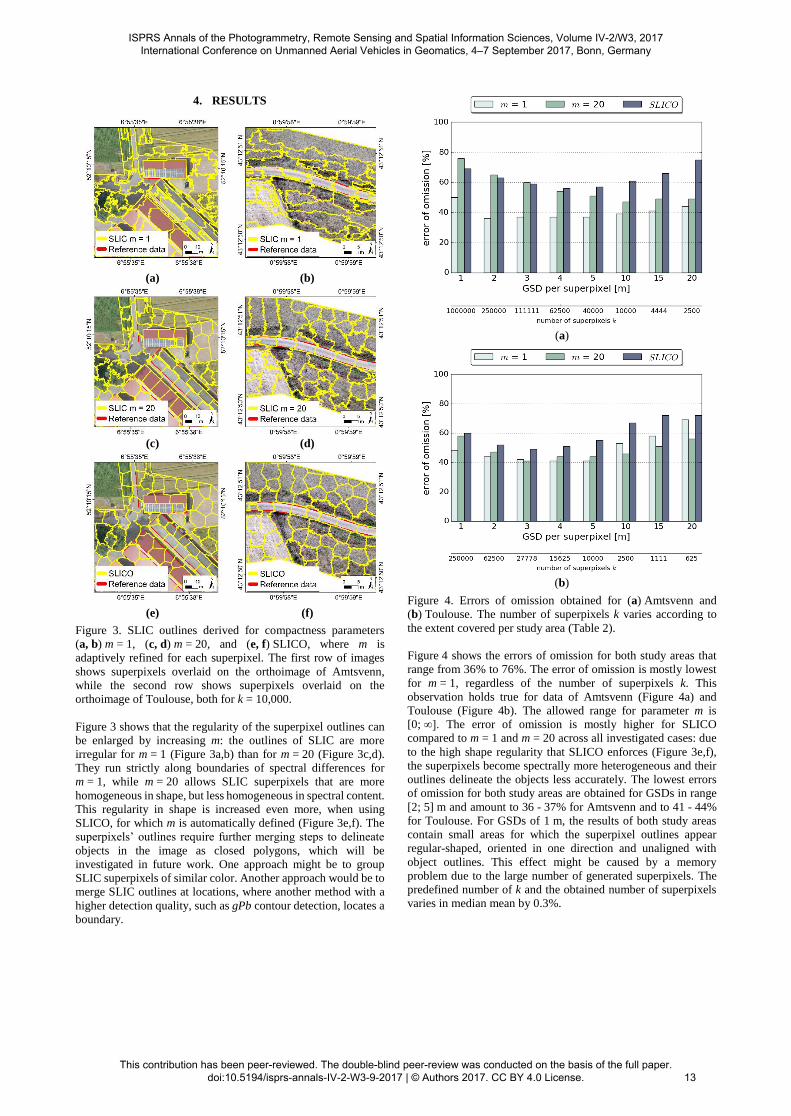
Figure 4. Errors of omission obtained for (a) Amtsvenn and
(b) Toulouse. The number of superpixels k varies according to
the extent covered per study area (Table 2).
Figure 4 shows the errors of omission for both study areas that
range from 36% to 76%. The error of omission is mostly lowest
for m = 1, regardless of the number of superpixels k. This
observation holds true for data of Amtsvenn (Figure 4a) and
Toulouse (Figure 4b). The allowed range for parameter m is
[0; ∞]. The error of omission is mostly higher for SLICO
compared to m = 1 and m = 20 across all investigated cases: due
to the high shape regularity that SLICO enforces (Figure 3e,f),
the superpixels become spectrally more heterogeneous and their
outlines delineate the objects less accurately. The lowest errors
of omission for both study areas are obtained for GSDs in range
[2; 5] m and amount to 36 - 37% for Amtsvenn and to 41 - 44%
for Toulouse. For GSDs of 1 m, the results of both study areas
contain small areas for which the superpixel outlines appear
regular-shaped, oriented in one direction and unaligned with
object outlines. This effect might be caused by a memory
problem due to the large number of generated superpixels. The
predefined number of k and the obtained number of superpixels
varies in median mean by 0.3%.
ISPRS Annals of the Photogrammetry, Remote Sensing and Spatial Information Sciences, Volume IV-2/W3, 2017 International Conference on Unmanned Aerial Vehicles in Geomatics, 4–7 September 2017, Bonn, Germany
This contribution has been peer-reviewed. The double-blind peer-review was conducted on the basis of the full paper. doi:10.5194/isprs-annals-IV-2-W3-9-2017 | © Authors 2017. CC BY 4.0 License.
13

(a)
(b)
Figure 5. Errors of commission obtained for (a) Amtsvenn and
(b) Toulouse. The number of superpixels k varies according to
the extent covered per study area (Table 2).
Figure 5 shows the errors of commission for both study areas that
range from 42% to 63%. These numbers strongly depend on the
chosen buffer size of 0.3 m around the reference data, in which
FP pixels are counted. For a smaller buffer size, the errors of
commission would be lower. This buffer size does not influence
the error of omission, as this error considers boundary pixels in
the reference map only. The errors of commission vary less per
GSD and in terms of the SLIC parameters compared to the errors
of omission. SLIC outlines need to be closed even when no object
outline is available in the image. This hinders the effacement of
the error of commission. The results indicate that this effect, i.e.,
the relative amount of erroneously labeled ‘outline’ pixels,
occurs equally across all investigated cases.
5. DISCUSSION
The results indicate that SLIC superpixels delineate object
outlines most accurately and completely using SLIC with a
compactness parameter m = 1 for superpixels’ GSDs in range
[2; 5] m. Depending on the extent covered in one orthoimage,
this results in a different number of superpixels defined as k
(Table 2). The regularity of object outlines to be delineated can
be considered when deciding on m or SLICO: SLICO results in
more regular-shaped outlines and can provide more suitable
results, when the object outlines are regular as well. When
applying SLIC, the regularity of shape outlines can be slightly
increased by increasing m.
The results from (Csillik, 2016), in which SLIC is applied to
satellite imagery of 0.5 - 0.6 m GSD are closest to those obtained
in this study. Csillik suggests using an initial superpixel size of
10 x 10 pixels and 10 iterations for the clustering and refinement
of the superpixels. The same number of iterations was used in
this study. It is proposed as default by MathWorks. The
superpixel size proposed by Csillik would correspond to
superpixels of 0.5 m GSD for the data of this study
(k = 4,000,000 for Amtsvenn; k = 1,000,000 for Toulouse). As
the error of omission increased for GSDs below 2 m and
corresponding values of k, these superpixel sizes were not
analysed in this study. Furthermore, UAV data can be analysed
by considering 3D information in addition to the orthoimage.
Future work will investigate the usability of SLIC on digital
surface models (DSM) as proposed by Csillik. This could be done
by applying gPb contour detection and SLIC superpixels on a
DSM. This would allow to identify high gradients in high, which
indicate objects such as fences or walls. Incorporating such
information could help to localize missed outlines and to erase
shadow outlines that are erroneously captured as object outlines
(Figure 3a,c,e).
The accuracy assessment applied in this study is based on
(Goodchild and Hunter, 1997) and is similarly employed in
numerous further studies (Kumar et al., 2014; Shi et al., 2003;
Wiedemann, 2003; Wiedemann et al., 1998). It provides a
comprehensive and widely used measure for positional accuracy.
Disadvantages include its dependency on the applied buffer size
and its sole focus on positional accuracy. For this study, it
adequately measures to which extent SLIC outlines coincide with
actual object outlines. More extensive accuracy assessment
approaches suitable for the described application are listed in
(Crommelinck et al., 2016).
Furthermore, the manually delineated object outlines can contain
errors. However, the applied buffer of 0.1 m partly smoothes
inaccurately delineated outlines. Inaccuracies might be further
reduced by averaging the manually delineated outlines of
multiple human operators (Martin et al., 2004). In general,
manually drawn reference data is accepted to measure the degree
to which an automated system outperforms a human operator
(Mayer, 2008).
Even for a workflow that accurately and completely delineates
objects from UAV orthoimages, future work is required to
determine the amount of cadastral boundaries that are visible and
can thus be extracted automatically. However, even a partial
extraction of cadastral boundaries could improve the mapping
procedure in terms of cost and time. Furthermore, an accurate and
complete delineation of objects can be useful in further
application fields such as topographical mapping, road tracking
or building extraction.
6. CONCLUSION AND OUTLOOK
This study investigates automatic object delineation from optical
UAV data. This supports multiple application fields such as
recent endeavors in cadastral mapping, which aim to
automatically delineate objects that demarcate cadastral
boundaries from high-resolution optical sensor data. In this
application field, a suitable workflow is assumed to consists of
multiple feature extraction methods (Crommelinck et al., 2016).
This study has investigated the potential of SLIC superpixels to
delineate objects as part of such a workflow: SLIC was found to
be applicable to UAV orthoimages and feasible to accurately
delineate object outlines taking into account the high resolution
of 0.05 m provided by the UAV orthoimages.
ISPRS Annals of the Photogrammetry, Remote Sensing and Spatial Information Sciences, Volume IV-2/W3, 2017 International Conference on Unmanned Aerial Vehicles in Geomatics, 4–7 September 2017, Bonn, Germany
This contribution has been peer-reviewed. The double-blind peer-review was conducted on the basis of the full paper. doi:10.5194/isprs-annals-IV-2-W3-9-2017 | © Authors 2017. CC BY 4.0 License.
14
However, the method generates a large number of outlines that
do not demarcate object outlines. Future work will investigate the
combination of SLIC with the contour detection method
proposed in (Crommelinck et al., 2017). This contour detection
method has shown to provide a comprehensive initial detection
of candidate objects that could be verified and located exactly by
integrating SLIC outlines. In addition, information from DSMs
is intended to be incorporated along with the information from
RGB orthoimages.
The goal is a tool for cadastral boundary delineation that is highly
automatic, generic and adaptive to different scenarios. The tool
will be most suitable for areas in which objects are clearly visible
and coincide with cadastral boundaries. Once the design and
implementation of such a tool is tested, its transferability to real
world scenarios will be investigated. This will be done in
countries like Kenya, Rwanda and Ethiopia, where concepts like
fit-for-purpose (Enemark et al., 2014) and responsible land
administration (Zevenbergen et al., 2015) are accepted or in
place.
ACKNOWLEDGEMENTS
This work was supported by its4land, which is part of the
Horizon 2020 program of the European Union (project number
687828). We are grateful to Claudia Stöcker and DelAirTech for
capturing, processing and providing the UAV data.
REFERENCES
Achanta, R., Shaji, A., Smith, K., Lucchi, A., Fua, P., Susstrunk,
S., 2012. SLIC superpixels compared to state-of-the-art
superpixel methods. IEEE Transactions on Pattern Analysis and
Machine Intelligence, 34(11), pp. 2274-2282.
Achanta, R., Shaji, A., Smith, K., Lucchi, A., Fua, P., Süsstrunk,
S., 2010. SLIC Superpixels, EPFL Technical Report no. 149300.
Acuña, R.G.G., Tao, J., Breen, D., Breen, B., Pointing, S.,
Gillman, L., Klette, R., 2016. Robust Segmentation of Aerial
Image Data Recorded for Landscape Ecology Studies, in: Huang,
F., Sugimoto, A. (Eds.), Image and Video Technology. Springer
International Publishing, Cham, pp. 61-72.
Balint, C., 2016. GDAL Superpixels,
https://github.com/cbalint13/gdal-segment (3 March 2017).
Blaschke, T., 2010. Object based image analysis for remote
sensing. ISPRS Journal of Photogrammetry and Remote Sensing,
65(1), pp. 2-16.
Borenstein, E., Ullman, S., 2008. Combined top-down/bottom-
up segmentation. IEEE Transactions on Pattern Analysis and
Machine Intelligence, 30(12), pp. 2109-2125.
Bradski, G., 2016. OpenCV Superpixels,
http://docs.opencv.org/trunk/df/d6c/group__ximgproc__superpi
xel.html (3 March 2017).
Chen, Y., Qin, K., Liu, Y., Gan, S., Zhan, Y., 2012. Feature
modelling of high resolution remote sensing images considering
spatial autocorrelation. ISPRS International Archives of the
Photogrammetry, Remote Sensing and Spatial Information
Sciences, Volume XXXIX-B3, pp. 467-472.
Chen, Z., Wang, C., Wen, C., Teng, X., Chen, Y., Guan, H., Luo,
H., Cao, L., Li, J., 2016. Vehicle Detection in High-Resolution
Aerial Images via Sparse Representation and Superpixels. IEEE
Transactions on Geoscience and Remote Sensing, 54(1), pp. 103-
116.
Comaniciu, D., Meer, P., 2002. Mean shift: A robust approach
toward feature space analysis. IEEE Transactions on Pattern
Analysis and Machine Intelligence, 24(5), pp. 603-619.
Crommelinck, S., Bennett, R., Gerke, M., Nex, F., Yang, M.,
Vosselman, G., 2016. Review of automatic feature extraction
from high-resolution optical sensor data for UAV-based cadastral
mapping. Remote Sensing, 8(8), pp. 1-28.
Crommelinck, S., Bennett, R., Gerke, M., Yang, M., Vosselman,
G., 2017. Contour detection for UAV-based cadastral mapping.
Remote Sensing, 9(2), pp. 171.
Csilik, O., Lang, S. Improving the speed of multiresolution
segmentation using SLIC superpixels. In: GEOBIA, Enschede,
the Netherlands, 14-16 September 2016, pp. 1-4.
Csillik, O. Superpixels: the end of pixels in OBIA. A comparison
of stat-of-the-art superpixel methods for remote sensing data. In:
GEOBIA, Enschede, the Netherlands, 14-16 September 2016, pp.
1-5.
Enemark, S., Bell, K.C., Lemmen, C., McLaren, R., 2014. Fit-
For-Purpose land administration. International Federation of
Surveyors, Frederiksberg, Denmark.
Felzenszwalb, P.F., Huttenlocher, D.P., 2004. Efficient graph-
based image segmentation. International Journal of Computer
Vision, 59(2), pp. 167-181.
GDAL Development Team, 2016. GDAL - Geospatial Data
Abstraction Library, Version 2.1.2. Open Source Geospatial
Foundation, www.gdal.org (3 March 2017).
Goodchild, M.F., Hunter, G.J., 1997. A simple positional
accuracy measure for linear features. International Journal of
Geographical Information Science, 11(3), pp. 299-306.
GRASS Development Team, 2015. Geographic Resources
Analysis Support System (GRASS) Software, Version 7.0.,
https://grass.osgeo.org/ (3 March 2017).
Kanavath, R., Metz, M., 2017. GRASS SLIC Superpixels,
https://grass.osgeo.org/grass72/manuals/addons/i.superpixels.sli
c.html (3 March 2017).
Kumar, M., Singh, R., Raju, P., Krishnamurthy, Y. Road network
extraction from high resolution multispectral satellite imagery
based on object oriented techniques. In: ISPRS Technical
Commission VIII Symposium, Hyderabad, India, 09-12
December, pp. 107-110.
Levinshtein, A., Sminchisescu, C., Dickinson, S., 2010. Optimal
contour closure by superpixel grouping, in: Daniilidis, K.,
Maragos, P., Paragios, N. (Eds.), Computer Vision – ECCV
2010: 11th European Conference on Computer Vision,
Heraklion, Crete, Greece, September 5-11, 2010, Proceedings,
Part II. Springer, Berlin, Heidelberg, pp. 480-493.
Levinshtein, A., Sminchisescu, C., Dickinson, S., 2012. Optimal
image and video closure by superpixel grouping. International
Journal of Computer Vision, 100(1), pp. 99-119.
Levinshtein, A., Stere, A., Kutulakos, K.N., Fleet, D.J.,
Dickinson, S.J., Siddiqi, K., 2009. Turbopixels: Fast superpixels
ISPRS Annals of the Photogrammetry, Remote Sensing and Spatial Information Sciences, Volume IV-2/W3, 2017 International Conference on Unmanned Aerial Vehicles in Geomatics, 4–7 September 2017, Bonn, Germany
This contribution has been peer-reviewed. The double-blind peer-review was conducted on the basis of the full paper. doi:10.5194/isprs-annals-IV-2-W3-9-2017 | © Authors 2017. CC BY 4.0 License.
15

using geometric flows. IEEE Transactions on Pattern Analysis
and Machine Intelligence, 31(12), pp. 2290-2297.
Maire, M., Arbeláez, P., Fowlkes, C., Malik, J. Using contours to
detect and localize junctions in natural images. In: IEEE
Conference on Computer Vision and Pattern Recognition
(CVPR'08), Anchorage, AK, USA, 23-28 June, pp. 1-8.
Malisiewicz, T., Efros, A.A. Improving spatial support for
objects via multiple segmentations. In: British Machine Vision
Conference (BMVC'07), Coventry, UK, 10-13 September 2007,
pp. 1-11.
Martin, D.R., Fowlkes, C.C., Malik, J., 2004. Learning to detect
natural image boundaries using local brightness, color, and
texture cues. IEEE Transactions on Pattern Analysis and
Machine Intelligence, 26(5), pp. 530-549.
MathWorks, 2016. MATLAB Superpixels,
https://nl.mathworks.com/help/images/ref/superpixels.html (3
March 2017).
Mayer, H., 2008. Object extraction in photogrammetric computer
vision. ISPRS Journal of Photogrammetry and Remote Sensing,
63(2), pp. 213-222.
Moore, A.P., Prince, S.J., Warrell, J., Mohammed, U., Jones, G.
Superpixel lattices. In: IEEE Conference on Computer Vision
and Pattern Recognition (CVPR'08), Anchorage, AK, US, 23-28
June 2008, pp. 1-8.
Neubert, P., Protzel, P. Superpixel benchmark and comparison.
In: Proc. of Forum Bildverarbeitung, Regensburg, Germany, 29-
30 November 2012, pp. 1-12.
Ortiz Toro, C.A., Gonzalo Martín, C., García Pedrero, Á.,
Menasalvas Ruiz, E., 2015. Superpixel-based roughness measure
for multispectral satellite image segmentation. Remote Sensing,
7(11), pp. 14620-14645.
Pantofaru, C., Schmid, C., Hebert, M. Object recognition by
integrating multiple image segmentations. In: European
Conference on Computer Vision (ECCV'08), Marsaille, France,
12-18 October 2008, pp. 481-494.
QGIS Development Team, 2009. QGIS Geographic Information
System. Open Source Geospatial Foundation, www.qgis.org (3
March 2017).
Ren, X., Malik, J. Learning a classification model for
segmentation. In: IEEE International Conference on Computer
Vision (ICCV’03), Washington, DC, USA, 13-16 October 2003,
pp. 10-17.
Russell, B.C., Freeman, W.T., Efros, A.A., Sivic, J., Zisserman,
A. Using multiple segmentations to discover objects and their
extent in image collections. In: IEEE Conference on Computer
Vision and Pattern Recognition (CVPR’06), New York, NY, US,
pp. 1605-1614.
Sahli, S., Lavigne, D.A., Sheng, Y., 2012. Saliency region
selection in large aerial imagery using multiscale SLIC
segmentation. Procedings of SPIE, 8360(1), pp. 1-8.
Schick, A., Fischer, M., Stiefelhagen, R. Measuring and
evaluating the compactness of superpixels. In: International
Conference on Pattern Recognition (ICPR'12), Tsukuba Science
City, Japan, 11-15 November 2012, pp. 930-934.
Scikit-Learn Developers, 2012. Scikit SLIC Superpixels,
http://scikit-
image.org/docs/dev/api/skimage.segmentation.html#skimage.se
gmentation.slic (3 March 2017).
Shi, J., Malik, J., 2000. Normalized cuts and image segmentation.
IEEE Transactions on Pattern Analysis and Machine
Intelligence, 22(8), pp. 888-905.
Shi, W., Cheung, C.K., Zhu, C., 2003. Modelling error
propagation in vector-based buffer analysis. International
Journal of Geographical Information Science, 17(3), pp. 251-
271.
Stutz, D., 2015. Superpixel segmentation: An evaluation, in:
Gall, J., Gehler, P., Leibe, B. (Eds.), Pattern Recognition: 37th
German Conference, GCPR 2015, Aachen, Germany, October 7-
10, 2015, Proceedings. Springer, Cham, pp. 555-562.
Stutz, D., Hermans, A., Leibe, B., 2017. Superpixels: An
Evaluation of the State-of-the-Art. Computer Vision and Image
Understanding, pp.
Thompson, D.R., Mandrake, L., Gilmore, M.S., Castano, R.,
2010. Superpixel endmember detection. IEEE Transactions on
Geoscience and Remote Sensing, 48(11), pp. 4023-4033.
Vargas, J., Falcao, A., dos Santos, J., Esquerdo, J., Coutinho, A.,
Antunes, J. Contextual superpixel description for remote sensing
image classification. In: IEEE International Geoscience and
Remote Sensing Symposium (IGARSS'15), pp. 1132-1135.
Vedaldi, A., 2013. VLFeat SLIC Superpixels,
http://www.vlfeat.org/api/slic.html (3 March 2017).
Vincent, L., Soille, P., 1991. Watersheds in digital spaces: An
efficient algorithm based on immersion simulations. IEEE
Transactions on Pattern Analysis and Machine Intelligence,
13(6), pp. 583-598.
Wiedemann, C., 2003. External evaluation of road networks.
ISPRS International Archives of the Photogrammetry, Remote
Sensing and Spatial Information Sciences, XXXIV-3/W8, pp.
93-98.
Wiedemann, C., Heipke, C., Mayer, H., Jamet, O., 1998.
Empirical evaluation of automatically extracted road axes, in:
Bowyer, K.W., Phillips, P.J. (Eds.), Empirical evaluation
techniques in computer vision. IEEE Computer Society Press,
Los Alamitos, CA, USA, pp. 172–187.
Williamson, I., Enemark, S., Wallace, J., Rajabifard, A., 2010.
Land administration for sustainable development. ESRI Press
Academic, Redlands, CA, USA.
Yang, M.Y., Rosenhahn, B. Superpixel cut for figure-ground
image segmentation. In: XXIII ISPRS Congress, Prague, Czech
Republic, 12-19 July 2016, pp. 387-394.
Zevenbergen, J., Bennett, R. The visible boundary: More than
just a line between coordinates. In: GeoTechRwanda, Kigali,
Rwanda, 18-20 November, pp. 1-4.
Zevenbergen, J., De Vries, W., Bennett, R.M., 2015. Advances
in responsible land administration. CRC Press, Padstow, UK.
Zhang, G., Jia, X., Hu, J., 2015. Superpixel-based graphical
model for remote sensing image mapping. IEEE Transactions on
Geoscience and Remote Sensing, 53(11), pp. 5861-5871.
ISPRS Annals of the Photogrammetry, Remote Sensing and Spatial Information Sciences, Volume IV-2/W3, 2017 International Conference on Unmanned Aerial Vehicles in Geomatics, 4–7 September 2017, Bonn, Germany
This contribution has been peer-reviewed. The double-blind peer-review was conducted on the basis of the full paper. doi:10.5194/isprs-annals-IV-2-W3-9-2017 | © Authors 2017. CC BY 4.0 License. 16


