SKAMANIA COUNTY PLANNING COMMISSION
268
SKAMANIA COUNTY PLANNING COMMISSION Skamania County Community Development Department PO Box 1009 ▪ 170 NW Vancouver Avenue, Stevenson, WA 98648 (509) 427-3900 ▪ [email protected] AGENDA Tuesday, November 16, 2021, 6:15 PM SKAMANIA COUNTY COURTHOUSE ANNEX, LOWER MEETING ROOM 170 NW VANCOUVER AVENUE, STEVENSON, WA 98648 REMOTE PARTICIPATION BY ZOOM MEETING TELEPHONE AND VIDEO CONFERENCE Please Note: Meeting attendees must wear a proper face covering regardless of vaccination status and maintain six feet of physical distance between other persons. Seating will be on a first come, first serve basis. Attendees may participate remotely by Zoom Meeting using the information below. 1. CALL TO ORDER 2. PLEDGE OF ALLEGIANCE 3. ROLL CALL 4. AGENDA ITEMS a. Approval of minutes from the November 2, 2021, Planning Commission Meeting. b. Public Hearing, Consideration, and Vote on proposed amendments to Title 22 (Columbia River Gorge National Scenic Area Ordinance). The proposal includes mandatory amendments to bring Title 22 into consistency with recently adopted amendments to the Management Plan for the Columbia River Gorge National Scenic Area by the Columbia River Gorge Commission as part of the Gorge 2020 update process. 5. PLANNING COMMISSION BUSINESS 6. ADJOURN Participation Instructions: To join the Zoom meeting online, visit https://us02web.zoom.us/j/6564597957. To join by telephone, call (253) 215-8782, and enter the following meeting ID when prompted: 656 459 7957
Transcript of SKAMANIA COUNTY PLANNING COMMISSION
SKAMANIA COUNTY PLANNING COMMISSION
Skamania County Community Development Department PO Box 1009 ▪ 170 NW Vancouver Avenue, Stevenson, WA 98648
(509) 427-3900 ▪ [email protected]
AGENDA
Tuesday, November 16, 2021, 6:15 PM
SKAMANIA COUNTY COURTHOUSE ANNEX, LOWER MEETING ROOM
170 NW VANCOUVER AVENUE, STEVENSON, WA 98648
REMOTE PARTICIPATION BY ZOOM MEETING TELEPHONE AND VIDEO CONFERENCE
Please Note: Meeting attendees must wear a proper face covering regardless of vaccination status and maintain six feet of physical distance between other persons. Seating will be on a first come, first serve basis. Attendees may participate remotely by Zoom Meeting using the information below.
1. CALL TO ORDER
2. PLEDGE OF ALLEGIANCE
3. ROLL CALL
4. AGENDA ITEMS
a. Approval of minutes from the November 2, 2021, Planning Commission Meeting.
b. Public Hearing, Consideration, and Vote on proposed amendments to Title 22 (Columbia River Gorge National Scenic Area Ordinance). The proposal includes mandatory amendments to bring Title 22 into consistency with recently adopted amendments to the Management Plan for the Columbia River Gorge National Scenic Area by the Columbia River Gorge Commission as part of the Gorge 2020 update process.
5. PLANNING COMMISSION BUSINESS
6. ADJOURN
Participation Instructions:
To join the Zoom meeting online, visit https://us02web.zoom.us/j/6564597957.
To join by telephone, call (253) 215-8782, and enter the following meeting ID when
prompted: 656 459 7957

SKAMANIA COUNTY PLANNING COMMISSION
Planning Commission Meeting Minutes 1
MINUTES
Tuesday, November 2, 2021, 6:15 PM
SKAMANIA COUNTY COURTHOUSE ANNEX, LOWER MEETING ROOM 170 NW VANCOUVER AVENUE, STEVENSON, WA 98648
REMOTE PARTICIPATION BY ZOOM MEETING TELEPHONE AND VIDEO CONFERENCE
1. CALL TO ORDER Sue Davis, acting Chair, called the meeting to order at 6:15 PM.
2. PLEDGE OF ALLEGIANCE Sue Davis led the Pledge of Allegiance.
3. ROLL CALL Planning Commissioners Present: Ken Bajema, Ann Cline (participated remotely), Anita Gahimer Crow, Sue Davis, Mat Joy (participated remotely) Absent: Cyndi Soliz Staff Present: Mike Beck, Andrew Lembrick, Alan Peters
4. AGENDA ITEMS a. Approval of minutes from the October 19, 2021, Planning Commission Meeting.
Ken Bajema moved to approve the minutes of the October 19, 2021, Planning Commission Meeting as presented. Anita Gahimer Crow seconded the motion. Motion passed 5-0.
b. Discussion of amendments to Title 22, Columbia River Gorge National Scenic Area Ordinance.
Acting Chair Sue Davis opened the workshop. She stated that the Planning Commission had previously proposed creating a committee to review the Title 22 amendments, but Staff instead scheduled an additional workshop being held tonight. Alan Peters gave a presentation on the background of the National Scenic Area, the Management Plan, and Title 22. Mr. Peters outlined some of the changes that have been incorporated into the draft amendments, including mandatory changes and other changes proposed by Staff. He also discussed the benefits of maintaining the county’s implementation of Title 22 and potential consequences of rescinding the ordinance.
SKAMANIA COUNTY PLANNING COMMISSION
Planning Commission Meeting Minutes 2
Sue Davis opened up the meeting for public comment. The following members of the public provided comments:
1. Scott Burns, property owner 2. Tamara Kaufman, Gorge Commissioner appointed by Skamania County 3. Aiden Forsi, Columbia River Gorge Commission 4. Mike Mullett, property owner 5. Steve McCoy, Friends of the Columbia Gorge
Alan Peters provided responses to questions or comments posed by the public and emphasized that Staff appreciated the public’s comments and invited any feedback on the draft document.
Sue Davis invited the Planning Commissioners to respond to the presentation and comments. Ann Cline introduced herself and expressed her willingness to assist with typographical edits to the document. Ken Bajema stated that he did not believe the changes were in the interest of residents. Mat Joy stated that he would have more to say at the upcoming hearing, but that he determined this was not to right time to rescind Title 22. Anita Gahimer Crow discussed the parts of the proposal that were initiated by staff. Staff expressed their willingness to meet with any Planning Commissioners over the next couple of weeks to discuss the proposal in more detail. The meeting was disrupted when the internet disconnected momentarily.
5. PLANNING COMMISSION BUSINESS Staff reminded the Planning Commission that there would be a public hearing on the Title 22 updates at the November 16, 2021, meeting.
6. ADJOURN
Sue Davis adjourned the meeting at 7:49 PM.

Title 22 Amendments 1
STAFF REPORT
TO: Skamania County Planning Commission FROM: Alan Peters, Community Development Director Mike Beck, Planner REPORT DATE: November 10, 2021 HEARING DATE: November 16, 2021 PROPOSAL: Zoning code amendments to Title 22 (Columbia River Gorge National
Scenic Area Ordinance) to bring Title 22 into consistency with recently adopted amendments to the Management Plan for the Columbia River Gorge National Scenic Area by the Columbia River Gorge Commission.
Background and Review Process Skamania County implements the Management Plan for the Columbia River Gorge National Scenic Area (NSA) through its own adopted ordinance, Title 22 – Columbia River Gorge National Scenic Area Ordinance. Title 22 is the zoning code for approximately 78,000 acres of land in unincorporated Skamania County located within the General Management Area and Special Management Area of the NSA. Four other gorge counties (Clark in Washington; Multnomah, Hood River, and Wasco in Oregon) have also adopted their own NSA ordinances, allowing the counties to administer NSA land use regulations in their own counties. Klickitat County has not adopted an NSA ordinance, instead granting the Gorge Commission the authority to directly review developments within that county. On October 13, 2020, the Gorge Commission adopted a revised Management Plan for the National Scenic Area which includes changes to policies and guidelines in both the General Management Area and Special Management Area. As required by the National Scenic Area Act, the revised plan was granted concurrence by the Secretary of Agriculture on February 19, 2021. These updates were the product of “Gorge 2020” a multi-year update process led by the Gorge Commission and Forest Service to revise the Management Plan. The Gorge Commission formally notified the county of these updates to the Management Plan on March 16, 2021 (see attached). Pursuant to the 270-day timeline prescribed by the National Scenic Area Act, the county has until December 11, 2021, to adopt the revised plan into its land use ordinance. A public hearing on the proposed amendments is scheduled for November 16, 2021. Notice of this hearing was published in the Skamania County Pioneer on November 3, 2021, and on the County’s website. A State Environmental Policy Act Determination of Nonsignificance was issued
Skamania County Community Development Department Building/Fire Marshal Environmental Health Planning
Skamania County Courthouse Annex Post Office Box 1009
Stevenson, Washington 98648 Phone: 509-427-3900 Inspection Line: 509-427-3922

Title 22 Amendments 2
for the proposal on November 3, 2021. After holding a public hearing, the Planning Commission may make a recommendation to the Board of County Commissioners who may then adopt the proposed amendments. After local adoption, the amendments will be submitted to the Gorge Commission and US Forest Service for a consistency determination. The amendments will become effective only after both agencies have made this determination. Proposed Text Amendments The proposal involves amendments to Skamania County Code Title 22 in order to make the County’s National Scenic Area Land Use Ordinance consistent with the recent Management Plan updates. The Management Plan is a type of comprehensive plan which contains goals, objectives, policies, and guidelines for scenic, cultural, natural, and recreation resources and for each land use (zoning) designation. The Gorge 2020 revision results in amendments to almost every chapter of Title 22. Community Development Staff has also taken this opportunity to make additional amendments to Title 22, including reorganization of some sections of code and amendments related to implementation of existing regulations. One significant change initiated by Staff is the addition of new guidelines to enable the development of recreational resorts in the GMA – Commercial Recreation zone. Since the November 2nd workshop, Staff has continued to revise and improve the draft text amendments. In addition to corrections to typographical and grammatical errors, numbering, and organization, Staff has made the following changes throughout the document: • Consistency review of cross-references – ensured references refer to correct code
section • Removed superfluous language from cross-references - ex. Section 22.12.040 “the
provisions in ‘Disposal Sites for Spoil Materials from Public Road Maintenance Activities’” • Style uniformity – spelled out numbers less than 100 in addition to numeral • Style uniformity – italicized all references to outside documents – ex. Manual of Uniform
Traffic Control Devices Amendments proposed by County Staff Description Page Summary Kitchen definition 18 Provides clarity on what constitutes a kitchen. Assists
with implementation and avoiding creation of illegal dwellings.
Property owner signature, application requirement
34 Signature may come from property owner on title or from easement holder, but the applicant must also provide proof that notice was provided to all ownership interests.
Expedited Development Review, Notice of Decision
46 Send out “notice” of decision rather than full written decision at time of approval. Will save printing and mailing costs while still meeting intent of current code.
Replacement structure size 49 When structures are destroyed by disaster, the code states they must be the same size or can increase by 10%. New language would allow for replacements to be smaller in size.
Title 22 Amendments 3
Recreation Resorts 90 New guidelines would enable the creation of recreational resorts in the Commercial Recreation zone on former industrial sites (Broughton Mill).
Glass areas 156 Reflects current policy. Visible glass limited to 50 sq. ft., can be greater on building faces not visible from key viewing areas.
Geotechnical Report 158 Dwellings are generally prohibited on slopes greater than 30%, though can be allowed with a variance. Requiring a geotechnical report would be consistent with non-NSA requirements and help support variance request.
Hazard Tree Removal 177 No current policies to allow removal of hazard trees in riparian areas. Would allow for removal with 2:1 mitigation consistent with Shoreline Master Program and Critical Areas Ordinance.
Amendments required by Management Plan Description Page Summary Tribal Comments 41,52,191 Revised tribal comment periods and notice requirements
for treaty rights and cultural resources. Earlier tribal involvement can avoid issues later in review process.
Cluster Development 56 Removing the provision for cluster developments. Cluster developments were rarely proposed, and opportunities for these kinds of land divisions are limited.
Commercial Events 74 Clarifying the guidelines for commercial events by modifying the description of types of commercial events allowed, adding a definition, and adding monitoring requirements.
Home Occupations 77 Combined cottage occupations and home occupations into one, similar to recent non-NSA county changes.
Hardship Dwellings 83 Previously allowed only mobile homes, RVs or manufactured homes can now be utilized as hardship dwellings.
Renewable Energy 88 Standards for development of solar systems. Similar to recent non-NSA county changes.
Overnight Accommodations 89 Allowance for a type of short-term rental in certain residential zones. New definitions would disallow any short-term rentals that are not specifically allowed as bed and breakfasts or overnight accommodations.
Agricultural Income 98, others Updating the income requirement for new dwellings on agricultural land, requiring applicants to produce $80,000 in gross agricultural income in 2020 dollars, indexed annually to inflation, before a dwelling can be permitted.
Cideries 100, others Add allowance for cideries meeting same requirements as wineries already allowed.
Farm and Produce Stands 15 Allow fruit and produce stands to sell a broader range of agricultural products and other incidental materials.
Scenic Compatibility 153 Exemption for buildings that are 1,500 square feet or less from the compatibility guideline for scenic resource protection. More specific, detailed compatibility analysis for buildings larger than 1,500 square feet.
Title 22 Amendments 4
Wetlands/Water Resources 165 Various changes to standards for wetland/non-wetland resource development. Except for Wind River, Little White Salmon Rover, and White Salmon River, all buffers remain the same.
Priority Habitats 177 Change in terminology from sensitive wildlife areas or sites to Priority Habitats or sensitive wildlife sites.
Rare Plants 189 Change in terminology from sensitive plants to rare plants.
Recreational Intensity Classes
200 Incorporating recreation settings into Recreation Intensity Classes that determine the types of recreational uses appropriate on any site.
Review Criteria and Findings Skamania County Code (SCC) Chapter 21.18 – Zoning Text and Map Amendments
21.18.020 Textual amendments. The board of county commissioners, upon recommendation of the planning commission, or upon its own motion and referral to and report from the planning commission and after a public hearing, may amend, delete, supplement, or change by ordinance the regulations herein established, provided such revision is in accordance with the procedures set forth in RCW 36.70. An amendment to the text of this title may only be initiated by the board of county commissioners or the planning commission and shall be consistent with the terms of the comprehensive plan.
Staff Findings: The proposed text amendments include mandatory changes required by the Columbia River Gorge Commission for Title 22 to be consistent with the Gorge 2020 Management Plan updates. The Planning Commission will hold a public hearing and make a recommendation to the Board of County Commissioners. No amendments to the comprehensive plan are required for these changes. Revised Code of Washington (RCW) 36.70 Planning Enabling Act
36.70.580 Official controls—Public hearing by commission. Before recommending an official control or amendment to the board for adoption, the commission shall hold at least one public hearing. 36.70.590 Official controls—Notice of hearing. Notice of the time, place and purpose of the hearing shall be given by one publication in a newspaper of general circulation in the county and in the official gazette, if any, of the county at least ten days before the hearing. The board may prescribe additional methods for providing notice. 36.70.600 Official controls—Recommendation to board—Required vote. The recommendation to the board of any official control or amendments thereto by the planning agency shall be by the affirmative vote of not less than a majority of the total members of the commission. Such approval shall be by a recorded motion which shall incorporate the findings of fact of the commission and the reasons for its action and the motion shall refer expressly to the maps, descriptive and other matters intended by the

Title 22 Amendments 5
commission to constitute the plan, or amendment, addition or extension thereto. The indication of approval by the commission shall be recorded on the map and descriptive matter by the signatures of the chair and the secretary of the commission and of such others as the commission in its rules may designate.
Staff Findings: A public hearing on the proposed amendments is scheduled for November 16, 2021. Notice of this hearing was published in the Skamania County Pioneer on November 3, 2021, and on the County’s website. After the public hearing, the Planning Commission may make a recommendation to the Board of County Commissioners on the proposed text amendments. Management Plan for the Columbia River Gorge National Scenic Area Part IV, Chapter 1, Section 6 – County Ordinances
1. Counties may adopt ordinances with provisions that vary from the policies and guidelines in the Management Plan as long as the ordinances provide greater protection for the scenic, cultural, natural, and recreation resources of the Scenic Area. Notwithstanding the designation policies in Part II of the Management Plan, the Gorge Commission shall, upon request from a local government, apply a more restrictive designation.
Staff Findings: The majority of proposed changes to Title 22 are mandatory changes required by Gorge 2020. These have been incorporated into Title 22 using language directly from the Management Plan or have been modified as necessary to add clarity or as necessary to fit within the format of Title 22. Other changes proposed by Staff provide greater resource protection either through their substance or by improving text clarity and document readability. Public Comment No public comment has been received as of the date of this report. The public hearing will provide an opportunity for the public to provide oral testimony regarding the proposal. Recommendation Based on the analysis in this report, Planning Staff recommends that the Planning Commission forward a positive recommendation to the Board of County Commissioners to approve the proposed amendments to Title 22. A model motion is included with this report. The Planning Commission may revise this motion as they see fit and may use this motion to articulate any concerns or sentiments regarding the proposal. Attachments
1. Model Motion 2. Redlines to Title 22
Page 1 of 2
SKAMANIA COUNTY PLANNING COMMISSION MOTION TO RECOMMEND APPROVAL OF
AMENDMENTS TO TITLE 22 (COLUMBIA RIVER GORGE NATIONAL SCENIC AREA ORDINANCE)
The Skamania County Planning Commission conducted a public hearing to consider proposed text amendments to Title 22 (Columbia River Gorge National Scenic Area Ordinance). The proposal includes mandatory amendments to bring Title 22 into consistency with recently adopted amendments to the Management Plan for the Columbia River Gorge National Scenic Area by the Columbia River Gorge Commission as part of the Gorge 2020 update process. I, _________________________, do hereby move that the Skamania County Planning Commission make the following Findings of Fact and Conclusions.
FINDINGS OF FACT
A. The Columbia River Gorge National Scenic Area (NSA) was created by the National Scenic Area Act (Act) in November 1986.
B. Land use regulations with the NSA are adopted by the Columbia River Gorge Commission (Gorge Commission) in the Management Plan for the Columbia River Gorge National Scenic Area (Management Plan).
C. The Act and the Columbia River Gorge Compact (RCW 43.97.015) require the County to adopt a land use ordinance consistent with the Management Plan and revise it from time to time as necessary to maintain consistency with the Management Plan. The County has adopted Title 22 in order to locally administer NSA regulations.
D. The Gorge Commission completed a plan revision in October 2020, requiring revisions to Skamania County Title 22.
E. The proposed revisions to Title 22 are required to maintain consistency with the Management Plan and maintain local control of the administration of NSA regulations.
F. The Planning Commission, having provided proper notice in the Skamania County Pioneer, and with a quorum present, conducted a public hearing at its November 16, 2021, meeting.
Skamania County Community Development Department Building/Fire Marshal Environmental Health Planning
Skamania County Courthouse Annex Post Office Box 1009
Stevenson, Washington 98648 Phone: 509-427-3900 Inspection Line: 509-427-3922

Page 2 of 2
CONCLUSIONS Based on public comment and staff analysis, the proposed amendments to Title 22 are necessary to maintain consistency with the Management Plan for the Columbia River Gorge National Scenic Area. Adoption of these amendments is in the best interest of county residents as it will allow Skamania County to retain local control of implementation of National Scenic Area regulations.
RECOMMENDATION Based upon the findings of fact and conclusions, I move that the Planning Commission recommend to the Board of County Commissioners that they adopt the proposed text amendments to Title 22. I further move that we recommend that the Board of County Commissioners use any and all authority to encourage the Gorge Commission to revisit the Management Plan as soon as allowable by law and to work with Skamania County and other Gorge counties to ensure that Management Plan guidelines better reflect the will of Gorge residents. Motion seconded by _________________________. AYE NAY Cyndi Soliz, Chair ___________________ __________________ Sue Davis, Vice Chair ___________________ __________________ Ken Bajema ___________________ __________________ Ann Cline ___________________ __________________ Anita Gahimer Crow ___________________ __________________ Mat Joy ___________________ __________________

1
SKAMANIA COUNTY CODE
TITLE 22 – COLUMBIA RIVER GORGE NATIONAL SCENIC AREA
CHAPTER 22.02 GENERAL PROVISIONS ..........................................................................2
CHAPTER 22.04 DEFINITIONS .............................................................................................6
CHAPTER 22.06 ADMINISTRATION .................................................................................32
CHAPTER 22.08 LAND DIVISIONS AND LOT LINE ADJUSTMENTS .........................56
CHAPTER 22.10 ZONING GENERAL REGULATONS (GMA AND SMA) ....................61
CHAPTER 22.12 ZONING SUPPLEMENTAL STANDARDS ON USES AND
STRUCTURES (GMA AND SMA) ..........................................................73
CHAPTER 22.14 ZONING CLASSIFICATIONS GENERAL MANAGEMENT
AREAS ......................................................................................................89
CHAPTER 22.16 ZONING CLASSIFICATIONS SPECIAL MANAGEMENT AREA....136
CHAPTER 22.18 SCENIC RESOURCE PROTECTION – GENERAL
MANAGEMENT AREAS.......................................................................152
CHAPTER 22.20 NATURAL RESOURCE PROTECTION – GENERAL
MANAGEMENT AREA .........................................................................165
CHAPTER 22.22 CULTURAL RESOURCE PROTECTION – GENERAL
MANAGEMENT AREAS.......................................................................186
CHAPTER 22.24 RECREATIONAL RESOURCE PROTECTION – GENERAL
MANAGEMENT AREAS.......................................................................200
CHAPTER 22.26 SCENIC RESOURCE PROTECTION – SPECIAL MANAGEMENT
AREAS ....................................................................................................210
CHAPTER 22.28 NATURAL RESOURCE PROTECTION – SPECIAL
MANAGEMENT AREAS.......................................................................216
CHAPTER 22.30 CULTURAL RESOURCE PROTECTION – SPECIAL
MANAGEMENT AREAS.......................................................................226
CHAPTER 22.32 RECREATIONAL RESOURCE PROTECTION – SPECIAL
MANAGEMENT AREAS.......................................................................241
CHAPTER 22.34 EMERGENCY MANAGEMENT PROVISIONS ..................................247

22.02 General Provisions 2
CHAPTER 22.02 GENERAL PROVISIONS
22.02.010 GENERAL TITLE .......................................................................................2
22.02.020 SHORT TITLE ............................................................................................2
22.02.030 PURPOSE ....................................................................................................2
22.02.040 SUBSTANTIVE AUTHORITY ..................................................................2
22.02.050 APPLICABILITY ........................................................................................2
22.02.060 EFFECTIVE DATE .....................................................................................3
22.02.070 MAPS ...........................................................................................................3
22.02.080 RELATIONSHIP TO OTHER LAWS ........................................................3
22.02.090 COORDINATION OF REVIEW AND PERMITTING PROCESS ...........3
22.02.100 UNIFORM APPLICATION OF MANAGEMENT PLAN ........................3
22.02.110 ENFORCEMENT ........................................................................................4
22.02.120 SAVINGS ....................................................................................................4
22.02.130 SEVERABILITY .........................................................................................5
22.02.010 GENERAL TITLE
The document codified in this Title shall be known as and may be cited as Skamania County
Code (SCC) Title 22 Columbia River Gorge National Scenic Area Code.
22.02.020 SHORT TITLE
The document codified in the Title may refer to itself internally as this Title, Title 22, or SCC
Title 22.
22.02.030 PURPOSE
The purpose of this Title is to implement the Revised Management Plan for the Columbia River
Gorge National Scenic Area as adopted on April 27, 2004 by the Columbia River Gorge
Commission and concurred with by the United States Secretary of Agriculture on August 3,
2004, and as subsequently amended.
22.02.040 SUBSTANTIVE AUTHORITY
The policies, standards, and regulations set forth in this Title are adopted pursuant to the
authority granted to the County under the Columbia River Gorge National Scenic Area Act and
Revised Code of Washington (RCW) Chapter 43.97; the comprehensive plan known as the
Management Plan for the Columbia River Gorge National Scenic Area adopted by the Columbia
River Gorge Commission originally on October 15, 1991, revised on April 27, 2004, as it may be
amended from time to time; the Planning Enabling Act (RCW Chapter 36.70); and the portions
of the Growth Management Act (RCW Chapter 36.70A).
22.02.050 APPLICABILITY
This Title applies to all lands in that portion of Skamania County lying within the Columbia
River Gorge National Scenic Area, as generally depicted on the map entitled "Boundary Map,
22.02 General Provisions 3
Columbia River Gorge National Scenic Area," numbered NSA-001 sheets 1 and 2, dated
September 1986, and to no other lands within the County, and specifically excluding all Urban
Areas shown on the same maps.
22.02.060 EFFECTIVE DATE
This Ttitle shall become effective upon adoption by the Skamania County Board of Skamania
County Commissioners, approved consistency review by the Columbia River Gorge
Commission, and concurrence by the United States Secretary of Agriculture. This Title, once
effective, shall replace any and all prior versions of Skamania County Code Title 22 Columbia
River Gorge National Scenic Area Code in its entirety.
22.02.070 MAPS
The Land Use Designations, Landscape Settings, and Recreation Intensity Classes maps adopted
by the Columbia River Gorge Commission as part of the Management Plan for the Columbia
River Gorge National Scenic Area are hereby incorporated by reference into this Title.
22.02.080 RELATIONSHIP TO OTHER LAWS
A. Regulation of activities under this Title is accomplished through a complicated mix of
federal, state and local statutes, ordinances, policies, regulations and agencies. The
granting by Skamania County of any Administrative Decision under the provisions of this
Title does not negate requirements to obtain additional permits from other local, state and
federal agencies or departments.
B. It is not the intent of this Title to repeal, abrogate or impair any existing regulations,
easement, covenants or deed restrictions. However, where this Title imposes greater
restrictions, the provisions of this Title shall prevail.
22.02.090 COORDINATION OF REVIEW AND PERMITTING PROCESS
All proposed development projects, not otherwise exempt by this Title, which are located with
the National Scenic Area, except Urban Areas, shall first complete the appropriate review
process as provided in this Title prior to completing other County level reviews, with the
exception of any reviews required under the State Environmental Policy Act (SEPA).
22.02.100 UNIFORM APPLICATION OF MANAGEMENT PLAN
A. The Management Plan shall be applied consistent with and in the spirit of the National
Scenic Area Act.
B. The Gorge Commission, Forest Service, and counties should strive to apply Management
Plan provisions uniformly throughout the National Scenic Area, except when a county
has adopted a more restrictive provision.
C. In applying provisions of the Management Plan within Counties that have not adopted
and put into effect a land use ordinance consistent with the Management Plan, the Gorge
Commission and Forest Service may consider, but shall not be constrained by, county
22.02 General Provisions 4
interpretations, state interpretation and application of state law and administrative
regulations, or judicial decisions that do not directly involve the Management Plan.
22.02.110 ENFORCEMENT
A. Any person or entity who knowingly violates any provision of this Title, or any
Administrative Decision, or Order of the Hearing Examiner relating to this Title, shall be
guilty of a violation punishable by a fine of not to exceed $500.00 per violation. A
violation will be deemed to occur for each day that the violation continues after the person
has been notified by certified mail or personal service of the alleged violation.
B. In the event the Administrator has sufficient basis to believe that a violation of this Title
has occurred, the Administrator will notify the property owner and the violator (if they
are not the same individuals) of the alleged violation by certified mail or personal service
and allow twenty (20) days for the property owner and/or violator to respond. A notice
of alleged violation shall contain substantially the following information:
1. The following shall appear at the top of the first page: “NOTICE OF ALLEGED
VIOLATION”;
2. a brief description of the nature of the alleged violation;
3. the name of the County Department and staff member to contact regarding the
alleged violation;
4. the date the alleged violation letter was issued; and,
5. that failure to correct the alleged violation or to contact the appropriate County
Department may result in a formal action to revoke any applicable permits and/or
the imposition of a fine of up to $500.00 per violation, and/or any other
appropriate legal action to address the violation.
C. In addition to any other legal remedies that may be available to the County to address the
violation, any person that has been served a notice of alleged violation as provided in
Section 22.02.110(B) may be cited into the Skamania County District Court which shall
have jurisdiction over all complaints involving alleged violations of Title 22. After
conduction a hearing, the Skamania County District Court may impose penalties as
provided in Section 22.02.110(A).
D. The imposition or the violator’s payment of a penalty shall not excuse the violation, or
permit the violator to continue to violate Title 22. All persons shall be required to correct
or remedy such violations or defects within a reasonable time as specified by the
Administrator. A violation will be deemed to occur for each day that the violation
continues after the person has been notified, including but not limited to the time that the
matter is pending before the Skamania County District Court.
22.02.120 SAVINGS
A. Nothing in this Title shall:
1. Affect or modify any treaty or other rights of any Indian tribe;
2. Except as provided in Section 13(c) of the National Scenic Area Act, authorize the
appropriation or use of water by any federal, state or local agency, Indian tribe or any
other entity or individual;
22.02 General Provisions 5
3. Affect the rights or jurisdictions of the United States, the states, Indian tribes or other
entities over waters of any river or stream or over any ground water resource or affect
or interfere with transportation activities on any such river or stream;
4. Alter, establish or affect the respective rights of the United States, the states, Indian
tribes, or any person with respect to any water or water-related right;
5. Alter, amend, repeal, interpret, modify or be in conflict with any interstate compact
made by the State of Washington prior to November 17, 1986;
6. Affect or modify the ability of the Bonneville Power Administration to operate,
maintain and modify existing transmission facilities;
7. Affect lands held in trust by the Secretary of the Interior for Indian tribes or
individual members of Indian tribes or other lands acquired by the Army Corps of
Engineers and administered by the Secretary of the Interior for the benefit of the
Indian tribes and individual members of Indian tribes;
8. Affect the laws, rules and regulations pertaining to hunting and fishing under existing
state and federal laws and Indian treaties;
9. Require any revision or amendment of any forest plan adopted pursuant to the
National Forest Management Act of 1976, Public Law 94-588, as amended, 16 U.S.C.
1600 et seq.; or
10. Establish protective perimeters or buffer zones outside of the Columbia River Gorge
National Scenic Area.
11. Affect the rights and responsibilities of non-federal timberland owners under the
Washington Forest Practices Act in General Management Areas.
22.02.130 SEVERABILITY
If any provision of this Title or its application to any person or circumstance is held invalid, the
remainder of this Title or the application of the provision to other persons or circumstances shall
not be affected.

22.04 Definitions 6
CHAPTER 22.04 DEFINITIONS
22.04.010 DEFINITIONS A THROUGH Z .................................................................6
22.04.010 DEFINITIONS A THROUGH Z
Wherever they appear in this chapter, the following terms shall have the following meanings:
-A-
1. ACCEPTED AGRICULTURAL PRACTICE means a mode of operation that is
common to farms or ranches of similar nature, necessary for the operation of such
farms or ranches to obtain a profit in money and customarily utilized in conjunction
with agricultural use.
1.2. ACCESSIBLE means development in compliance with the Federal accessibility
guidelines and standards. Accessible sites and facilities do not contain barriers
limiting their use by people with disabilities.
3. ACCESSORY STRUCTURE/BUILDING means a structure or detached building
whose use is incidental and subordinate to that of the main use of the property, and
that is located on the same parcel as the main building or use. The term “detached”
means that the main building and accessory building do not share a common wall.
An accessory building connected to the main building by a breezeway is a detached
building.
2.4. ACCESSORY RENEWABLE ENERGY SYSTEM means a system accessory to
a primary structure or allowed use on the parcel that converts energy into a usable
form such as electricity or heat and conveys that energy to the allowed structure or
use. An Accessory Renewable Energy System is a solar thermal, photovoltaic, or
wind turbine structure, or group of structures designed to offset all or part of the
annual energy requirements of the primary use on the subject parcel.
3.5. ACTIVE WILDLIFE SITE means a wildlife site that has been used within the
past five years by a sensitive wildlife species.
4.6. ADDITION means an extension or increase in the area or height of an existing
building.
5.7. ADMINISTRATOR means the Director of the Skamania County Department of
Planning and Community Development or a designee who has authority over a
proposed project review.
6.8. ADVERSELY AFFECT OR ADVERSELY AFFECTING means a reasonable
likelihood of more than moderate adverse consequences for the scenic, cultural,
recreation or natural resources of the National Scenic Areascenic area, the
determination of which is based on:
a. The context of a proposed action;
b. The intensity of a proposed action, including the magnitude and duration of an
impact and the likelihood of its occurrence;
c. The relationship between a proposed action and other similar actions which are
individually insignificant but which may have cumulatively significant impacts;
and
22.04 Definitions 7
d. Proven mitigation measures which the proponent of an action will implement as
part of the proposal to reduce otherwise significant effects to an insignificant
level.
9. AGRICULTURAL BUILDING means a building located on a farm or ranch and
used in the operation for the storage, repair, and maintenance of farm equipment
and supplies or for the raising or storage of crops and livestock. These include, but
are not limited to: barns, silos, workshops, equipment sheds, greenhouses, and
processing facilities.
7.10. AGRICULTURAL SPECIALIST (SMA) means a person such as a county
extension agent with a demonstrated knowledge of farming operations, and a
demonstrated ability to interpret and recommend methods to implement regulations
pertaining to agriculture. Such abilities are usually obtained through a combination
of higher education and experience.
8.11. AGRICULTURAL STRUCTURE/BUILDING means a structure (not including
buildings) structure or building located on a farm or ranch and used in the
operation. for the storage, repair and maintenance of farm equipment, and supplies
or the raising and/or storage of crops and livestock. These include, but are not
limited to: barns, silos, workshops, equipment sheds, greenhouses, wind machines
(orchards), processing facilities, storage bins, fences, trellises, and irrigation
systems. structures.
9.12. AGRICULTURAL USE means the current employment of land for the primary
purpose of obtaining a profit in money by raising, harvesting and selling of crops;
or by the feeding, breeding, management and sale of, or production of, livestock,
poultry, fur-bearing animals or honeybees; or for dairying and the sale of dairy
products; or any other agricultural or horticultural use, including Christmas trees.
Current employment does not include livestock feed lots. Current employment of
land for agricultural use includes:
a. The operation or use of farmland subject to any agriculture-related government
program;
b. Land lying fallow for one (1) year as a normal and regular requirement of good
agricultural husbandry;
c. Land planted in orchards or other perennial prior to maturity; and
d. Land under buildings supporting accepted agricultural practices.
d.e. Agricultural use does not include livestock feedlots.
10.13. AIR means the mixture of gases comprising the Earth’s atmosphere.
11.14. ANADROMOUS FISH means species of fish that migrate upstream
to freshwater after spending part of their life in the ocean.
12.15. ANAEROBIC means a condition in which molecular oxygen is
absent (or effectively so) from the environment.
13.16. AQUACULTURE means the cultivation, maintenance and
harvesting of aquatic species.
17. AQUATIC AREA means the water area of a stream, pond or lake, measured at the
ordinary high waterhigh-water mark.
14.18. ARCHAEOLOGICAL RESOURCE – see (49)CULTURAL
RESOURCE.
15.19. ARCHAEOLOGICAL SURVEY means actions conducted to
determine if archaeological resources are present in an area that would be affected

22.04 Definitions 8
by a proposed use. Archaeological surveys may include archival research, surface
surveys, subsurface testing and ethnographic research. An archaeological survey
may also be called a reconnaissance survey.
16.20. ARCHIVAL RESEARCH means research in primary documents
that is likely to yield information regarding human occupation of the area in
question, including but not limited to deed, census, cartographic and judicial
records.
-B-
21. BACKGROUND means one of the main visibility distance zones used to
determine relative sensitivity of a development, structure, or use based on its
distance from the viewer. Background is represented in the space from four miles to
the horizon.
17.22. BED AND BREAKFAST INN means an establishment located in a
structure designed as a single-family dwelling where more than two rooms but
fewer than six rooms are rented on a daily basis. Bed and breakfast inns are clearly
incidental to the use of a structure as a single-family dwelling and are owner
occupied and operated. Bed and breakfast inns operate as traveler transient
accommodation, not as rooming or boarding houses.
18.23. BEST MANAGEMENT PRACTICES (BMPs) means
conservation techniques and management measures that:
a. Control soil loss and reduce water quality degradation caused by nutrients,
animal waste, toxins, and sediment;
b. Minimize adverse effects to groundwater and surface-water flow and circulation
patterns; and
c. Maintain the chemical, biological, and physical characteristics of wetlands,
ponds, streams and riparian areas.
19.24. BIODIVERSITY (SMA) means a diversity of biological organisms
at the genetic, species, ecosystem and landscape levels.
20.25. BOAT LANDING means a cleared area or developed structure used
to facilitate launching or retrieving watercraft.
21.26. BUFFER ORor BUFFER ZONE means an area adjacent to a water
resource or other sensitive area that is established and managed to protect sensitive
natural resources from human disturbance. In instances that involve a wetland,
stream or pond, the buffer zone includes all or a portion of the riparian area.
22.27. BUILDING means any structure used or intended for supporting or
sheltering any use or occupancy. Buildings have a roof supported by columns or
walls. They include, but are not limited to, dwellings, garages, barns, sheds and
shop buildings.
-C-
28. CAMPING OR RECREATIONAL VEHICLE means a vacation trailer, camper,
self-propelled vehicle, or structure equipped with wheels for highway use that is
intended for recreational purposes, but not for residential purposes, and is equipped
with plumbing, sink, or toilet. A camping or recreational vehicle shall be considered
22.04 Definitions 9
a dwelling unit if it is (1) connected to a sewer system (including septic tank),
water, and electrical lines, or (2) is occupied on the same parcel for more than 60
days in any consecutive 12-month period.
23.29. CAMPSITE means a single camping unit that usually consists of a
cleared, level area for a tent and may include a parking spur, fire ring, table and
other amenities.
24.30. CAPABILITY means the ability of land to produce forest or
agricultural products due to characteristics of the land itself, such as soil, slope,
exposure or other natural factors.
25.31. CANOPY CLOSURE (SMA) means for forest practices, the
percentage measuring the degree to which one layer of a tree canopy blocks
sunlight or obscures the sky as measured from below.
26.32. CASCADIAN ARCHITECTURE (SMA) means an architectural
style using native rock work, large timber and steeply pitched roofs in a rustic
manner.
27.33. CATASTROPHIC SITUATIONS (SMA) means forces such as
fire, insect and disease infestations, and earth movements.
28.34. CHILD CARE CENTER means a facility providing day care to
three or more children, but not including:
a. The provision of care that is primarily educational unless provided to a
preschool child for more than four hours a day;
b. The provision of care that is primarily supervised training in a specific subject,
including but not limited to dancing, gymnastics, drama, music or religion;
c. Provision of short termshort-term care primarily an incident of group athletic or
social activities.
d. The provision of day care in the provider's home in the family living quarters
for less than thirteen (13) children.
35. COLUMBIA RIVER GORGE NATIONAL SCENIC AREA GRAPHIC
SIGNING SYSTEM means sign design standards developed for the National
Scenic Area for public signs in and adjacent to public road rights-of-way.
29.36. COLUMBIA RIVER TREATY TRIBES – see INDIAN TRIBES.
37. COMMERCIAL DEVELOPMENT OR /USE means any facility or use of land
or water whose function is primarily retail buying or selling of goods or services or
both. This does not include fruit or and produce stands.
30.38. COMMERCIAL EVENT means an organized gathering at an
allowed commercial development. Such events include weddings, receptions,
indoor concerts and farm dinners, and are incidental and subordinate to the primary
use on a parcel.
31.39. COMMERCIAL FOREST PRODUCTS includes timber for
lumber, pulp, and fire wood for commercial proposes.
32.40. COMMERCIAL RECREATION means any private (non-
governmental) recreational activity or facility on privately owned land, excluding
non-profit facilities. This does not include operation of a public recreation facility
by a private vendor.
33.41. COMMUNITY FACILITY means basic utilities and services
necessary to support public service needs, including, but not limited to water and

22.04 Definitions 10
power utilities, sanitation facilities, public micro-wave stations and communication
facilities, schools, road and highways. This does not include sanitary landfills.
34.42. CONSULTING PARTIES (cultural resources) means
organizations or individuals who submit substantive written comments to the
Planning Agency in a timely manner because they are concerned with the effects of
a proposed use on cultural resources.
35.43. CONTIGUOUS LAND means parcels or other lands that are under
the same ownership and have a common boundary, regardless of whether or not
portions of the parcels have separate tax not numbers, lie in different counties, lie in
different sections or government lots, lie in different land use or zoning
designations, or are separated by public or private roads. Contiguous land does not
include parcels which meet only at a single point.
36.44. COUNTY means Skamania County, its officials, agents,
representatives, commissions and boards, and whichever of them has made a
determination or performed a governmental action affecting a proposed use or
development regulated under this Title.
37.45. CREATED OPENING (SMA) means a created forest opening with
less than forty percent (40 %) average canopy closure of overstory trees and less
than sixty percent (60 %) average canopy closure of understory trees averaging less
than five (5) inches diameter at breast height for coniferous forests and less than
twenty-five percent (25 %) total canopy cover for oak woodlands. This definition
does not include agricultural fields.
38.46. CREATION OF WETLANDS means a human activity that
converts an upland into a wetland. This definition presumes that the area to be
converted has not been a wetland in recent times (100 to 200 years).
39.47. CULTIVATION means any activity that prepares land for raising
crops by turning, breaking, or loosening the soil. Cultivation includes plowing,
harrowing, leveling, and tilling.
40.48. CULTURAL RESOURCE means the objects, features, sites and
places that have meaning and significance for specific human groups and cultures.
Cultural resources support the cohesive bonds of the communities that recognize
and comprehend their significance. Cultural resources can be divided into four
types: Archaeological Resources, Historic Buildings, Traditional Cultural Properties
and Traditional Use Areas.evidence of human occupation or activity that is
important in the history, architecture, archaeology or culture of a community or
region. Cultural resources include, but are not limited to, the following:
i. a. ARCHAEOLOGICAL RESOURCES means the artifacts and features
left in the landscape of early American Indian activities and the historic
activities of early settlers. Artifacts are human-manufactured items and the
waste material from manufacture. Features are the human alterations in the
landscape. Artifacts include arrowheads and the stone waste flakes from making
them and historic cans, bottles, ceramics and wooden and metal objects left in
dumps or scattered in the landscape. Features include human-made pits in talus
slopes, stacked rocks, rock walls, blazed and scarred trees, ditches, railroad
grades, wagon roads, cabin foundations and other human modifications of the
natural landscape.. Physical evidence or ruins of human occupation or activity
that are located on or below the surface of the ground and are at least fifty (50)

22.04 Definitions 11
years old. Archaeological resources include, but are not limited to, the remains
of houses, villages, camp and fishing sites and cave shelters, rock art such as
petroglyphs and pictographs, artifacts such as arrowheads, utensils, tools,
fragments of tools and utensils, obsidian flakes or other material byproducts
from tool and utensil-making activities; and graves, human remains and
associated artifacts.
ii. b. HISTORIC BUILDINGS AND STRUCTURES means. standing
structures and their associated features that are at least fifty (50) years old.
Often, they are still in use but can be abandoned and deteriorating. They are
distinct from historic archaeological resources by being above ground and not
collapsed to the level of the surrounding landscape. Standing or above-ground
buildings and structures that are at least fifty (50) years old, including, but not
limited to, log cabins, barns, canals, flumes, pipelines, highways and tunnels.
c. TRADITIONAL CULTURAL PROPERTIES. means monumental sites,
sacred places, legendary areas, mythical locations, traditional gathering places,
and landscapes and landscape features that are identified by the specific
communities that hold meaning for them. They maintain and perpetuate values
and practices of the group that attach significance to them. They provide
spiritual connection to the community. Locations, buildings, structures and
objects that are associated with cultural beliefs, customs or practices of a living
community that are rooted in that community's history and are important in
maintaining the continuing cultural identity of the community. Traditional
cultural properties include, but are not limited to, sites associated with
traditional beliefs of a Native American group about its origins or its cultural
history; a location where a community has traditionally carried out artistic or
other cultural practices important in maintaining its historical identity; and a
location where Native American religious practitioners have historically gone,
and go today, to perform ceremonial activities. Objects may include
petroglyphs, pictographs, rock cairns or other rock structures, trees and rock
outcrops.
iii. d. TRADITIONAL USE AREAS means procurement and processing sites
in the landscape for every kind of resource a society needs to perpetuate its
specific culture. They are the sources for food, medicine, fibers and tools that
provide subsistence for a specific group’s culture.
49. CULTURALLY SIGNIFICANT FOODS means natural resources used by Native
Americans for subsistence, medicine and ceremony, including: water, fish, big
game, roots, and berries.
50. CULTURALLY SIGNIFICANT PLANTS AND WILDLIFE means native plant
and animal species essential to the culture of a Native American group.
41. CUMULATIVE EFFECTS means the combined effects of two (2) or more
activities. The effects may be related to the number of individual activities, or to the
number of repeated activities on the same piece of ground. Cumulative effects can
result from individually minor but collectively significant actions taking place over
a period of time.
51. CUMULATIVE EFFECTS means the combined effects of two (2) or more
activities. The effects may be related to the number of individual activities, or to the
number of repeated activities on the same piece of ground. Cumulative effects can
22.04 Definitions 12
result from individually minor but collectively significant actions taking place over
a period of time.
52. CUT means an area where soil or earth is excavated or removed in conjunction
with development activities.
42. CUT means an area where soil or earth is excavated or removed in conjunction
with development activities.
-D-
43.53. DEDICATED SITE means an area actively devoted to the current use, as
delineated on the site plan.
44.54. DEER AND ELK WINTER RANGE means areas normally used, or
capable of being used, by deer and elk from December through April.
45.55. DEPARTMENT means the Skamania County Department of Planning and
Community Development.
46.56. DESTRUCTION OF WETLANDS means a human activity which results in
the loss of a wetland or any of its component parts, including filling, draining, or
other activity having an adverse effect on the sustainable functioning of the
wetland.
47.57. DEVELOPED RECREATION means recreational opportunities
characterized by high-density use on specific sites and requiring facilities
installation. Density of use, amount of site development, and type of recreation site
can vary widely across the spectrum of recreation activities.
48.58. DEVELOPED ROAD PRISM (SMA) means the area of the ground
associated with a particular road and containing the road surface, ditch, shoulder,
retaining walls, or other developed features. Does not include the natural appearing
portions of cut and fill slopes.
49.59. DEVELOPMENT means any land division or new construction or
modification of buildings, structures, and roads, and any earth-moving activity,
including, but not limited to, including but not limited to new construction of
buildings and structures, and mining, dredging, filling, grading, paving and
excavation.
60. DIAMETER AT BREAST HEIGHT (dbh) means the diameter of a tree as
measured at breast height.
50.61. DISTANCE ZONE (see BACKGROUND, MIDDLEGROUND, and
FOREGROUND) are used to determine relative sensitivity of a development
structure or use based on its distance from the viewer. Generally, the closer a
development is to the area it is being viewed from, the more attention will need to
be given to the site placement, design features, and mitigations to ensure the
development blends with the landscape.
51.62. DUPLEX means a building containing two (2) dwelling units and designed
for occupancy by two families.
52. DWELLING, single-family means a detached building containing one dwelling
unit and designed for occupancy by one family only.
53.63. DWELLING UNIT means a single self-contained unit designed for
occupancy by one family and having not more than one cooking area or

22.04 Definitions 13
kitchen.with basic facility needs for day-to-day living. Basic facility needs include,
but are not limited to, a kitchen, sleeping area(s), and a bathroom.
-E-
54.64. EARTH MATERIALS means any rock, natural soil or any combination
thereof. Earth materials do not include non-earth or processed materials, including,
but not limited to, construction debris (e.g., concrete, asphalt, wood), organic waste
(e.g., cull fruit, food waste) and industrial byproducts (e.g., slag, wood waste).
55.65. EFFECT ON TREATY RIGHTS means to bring about a change in, to
influence, to modify, or to have a consequence to Indian treaty or treaty-related
rights in the Treaties of 1855 with the Nez Perce, Umatilla, Warm Springs and
Yakaima tribes executed between the individual Indian tribes and the Congress of
the United States and as adjudicated by the federal courts.
56.66. EMERGENCY/DISASTER means a sudden unexpected occurrence, either
the result of human or natural forces, necessitating immediate action to prevent or
mitigate significant loss or damage to life, health, property, essential public
services, or the environment.
57.67. EMERGENCY/DISASTER RESPONSE means actions involving any
development (such as new structures, grading, or excavation) or vegetation removal
that must be taken immediately in response to an emergency/disaster event (as
defined above). Emergency/disaster response actions not involving any structural
development or ground-disturbance (such as use of emergency transport vehicles,
communications activities or traffic control measures) are not included in this
definition and are not affected by these provisions.
58.68. ENDEMIC means plant and animal species that are found only in the vicinity
of the Columbia River Gorge area.
59.69. ENHANCEMENT (natural and scenic resources) means a human activity
that increases or makes greater the value, desirability or attractiveness of one or
more functions of an existing sensitive area. For riparian areas, such as wetlands,
streams, and lakes, enhancement is generally limited to the area that is degraded.
one or more functions of an existing sensitive watercourse or other area.
Enhancement is generally limited to a sensitive watercourse or area that is
degraded. Enhancing a sensitive natural resource n area that is in good or excellent
condition may reduce biological diversity and eliminate other natural functions and
may not be desirable.
70. EPHEMERAL STREAMS (SMA) means stream that contain flowing water only
during, and for a short duration after, precipitation events.
60.71. EQUITABLE RECREATION means development and services that are
equally accessible and available to all people regardless of income level, ethnicity,
gender, ability, or age.
72. ETHNOGRAPHY means the descriptive and analytic study of the culture of
particular groups. An ethnographer seeks to understand a group through interviews
with its members and often through living in and observing the group.
61.73. EXISTING INDUSTRIAL COMPLEX means areas including some
existing industrial use and where readily visible remnants of past industrial
activities exist. The complex includes buildings, including those abandoned or
22.04 Definitions 14
partially abandoned, paved areas, stockpiles, equipment storage areas, quarry areas,
etc., and may include isolated patches of vegetation or rock outcroppings
surrounded by areas described above. The complex does not extend to include areas
where evidence of past activity is no longer readily evident in the landscape.
62.74. EXISTING USE OR STRUCTURE means any use or structure that was
legally established and that has continued to operate lawfully and has not been
discontinued.
63.75. EXPLORATION, DEVELOPMENT (EXTRACTION AND
EXCAVATION) AND PRODUCTION OF NATURAL RESOURCES means
all or any part of the process of surface, underground or submerged mining of
mineral resources, and transportation of mineral resources from the site. including
all exploration, regardless of area disturbed or volume mined.
-F-
64.76. FILL means the placement, deposition or stockpiling of sand, sediment or
other earth materials to create new uplands or to create an elevation above the
existing surface.
65.77. FINISHED GRADE means the final elevation of the ground level of a
property after construction is completed.
66.78. FIRE BREAK means a break in ground cover fuels adjacent to and
surrounding buildings.
67.79. FOOTPRINT means the area that falls directly beneath and shares the same
perimeter as a structure.
68.80. FORBS means broad-leaved herbs, in contrast to ferns, fern allies and grasses
and grasslike plants.
69.81. FOREGROUND (SMA) means one of three main visibility distance zones
used to determine relative sensitivity of a development, structure, or use based on
its distance from the viewer. Foreground is represented in the space from zero (the
viewer) up to one-half (½) mile on either side of a traveled road or trail.
70.82. FOREST HEALTH (SMA) means a measure of the robustness of
forest ecosystems. Forests are deemed healthy when they have capacity across the
landscape for renewal, for the maintenance of wildlife habitats, for recovery from a
wide range of disturbances, and for retention of their resilience.
71.83. FOREST PRACTICE (SMA) means any activity conducted on or
directly pertaining to forested land and relating to forest ecosystem management
including but not limited to growing, thinning, or removing live or dead forest tree
or shrub species, road and trail construction, reforestation, fertilizing, brush control,
prevention of wildfire, and suppression of diseases and insects. The removal of
hazardous trees is excluded. Uses that include establishment, management or
harvest of Christmas trees, nursery stock, or fiber producing tree species requiring
intensive cultivation (irrigation, fertilization, etc.) and a harvest rotation of twelve
(12) years or less are considered agricultural uses.
72.84. FOREST PRACTICES (GMA) means those activities related to
the growing and harvesting of forest tree species as defined in the Washington State
Forest Practices Act.
22.04 Definitions 15
73.85. FOREST PRODUCTS means commodities produced from a forest,
including, but not limited to, timber products, boughs, mushrooms, pine cones, and
huckleberries.
74.86. FOREST SERVICE means the United States Department of
Agriculture Forest Service -, Columbia River Gorge National Scenic Area Office.
75.87. FOREST STAND STRUCTURE (SMA) means the number, types
and spacing of tree species, tree sizes, and canopy layers contained in a stand of
trees.
88. FOREST USE means growing, propagation and harvesting of forest tree species
and other forest products.
76.89. FRUIT AND PRODUCE STAND means a venue on a farm or
ranch selling produce and agricultural products primarily grown on the subject farm
or ranch. Associated incidental agricultural products from the local region and
associated incidental marketing materials shall not make up more than 25% of the
sales at the stand. Incidental products may include processed foods like jams and
jellies. Foods prepared for consumption on the premises are not permitted. Fruit and
produce stands are not a commercial use.
77.90. FULLY SCREENED means a description used when determining
compliance with the scenic standards (visually subordinate and not visually evident)
where a structure, development or use is not visible from a specific vantage point
(generally a key viewing area). See the “Scenic Resources Implementation
Handbook” for more information regarding screening for development in the
National Scenic Area. of the relative visibility of a structure where that structure is
not visible as viewed from a specified vantage point, generally a key viewing area.
-G-
91. GORGE COMMISSION means the Columbia River Gorge Commission.
78.92. GRADE (ground level) means the average elevation of the finished
ground elevation as defined by the International Building Code.
79.93. GRADING means any excavating or filling of earth materials or any
combination thereof, including the land in its excavated or filled condition.
-H-
80.94. HAZARD TREE (SMA) means a tree with a structural defect that
will predictably result in whole or partial failure within one-and-a-half (1½) tree
lengths of a road or maintained development. A defective tree is hazardous only
when its failure could result in danger to people or damage to structures, vehicles,
or other property.
81.95. HEIGHT OF BUILDING means the greatest vertical distance
between the point of lowest finished grade adjoining any exterior wall of a building
and the highest point of the roof, such as the highest coping or parapet of a flat roof,
the highest deck line of a mansard roof, or the highest ridge of a hip, gable,
gambrel, shed or other pitched roof.
82.96. HEARING EXAMINER is an appointed official vested with the
duties established by Skamania County Ordinance Number 2006-16.
22.04 Definitions 16
83.97. HERBACEOUS means a plant with no persistent woody stem
above the ground, with characteristics of an herb.
98. HERBS means nonwoody (herbaceous) plants, including grasses and grasslike
plants, forbs, ferns, fern allies, and nonwoody vines. Seedlings of woody plants
that are less than three feet tall are considered part of the herbaceous layer.
84.99. HISTORIC BUILDINGS AND STRUCTURES see CULTURAL
RESOURCE.
100. HISTORIC SURVEY means actions that document the form, style, integrity and
physical condition of historic buildings and structures. Historic surveys may
include archival research, architectural drawings and photographs.
85.101. HOME OCCUPATION means a small-scale commercial use
conducted in a legal single-family dwelling or accessory structure, employing the
residents of the dwelling and up to three outside employees. Periodic use of home
offices, studios, and other work areas used only by the residents of the dwelling are
not a home occupation.
86.102. HORSES, BOARDING OF (GMA) means the stabling, feeding
and grooming, or the use of stalls for and the care of horses not belonging to the
owner of the property, and related facilities, such as training arenas, corrals, and
exercise tracks. These facilities are either operated for a fee or by a nonprofit
organization.
87.103. HYDRIC SOIL means a soil that is saturated, flooded or ponded
long enough during the growing season to develop anaerobic conditions in the
upper part.
-I-
104. IMMEDIATE FOREGROUND FOR SCENIC CORRIDORS means a subset of
one of the three main visibility distance zones used to determine relative sensitivity
of a development, structure, or use based on its distance from the viewer.
Immediate foreground is represented in the space from zero (the viewer) up to one-
quarter mile. For scenic travel corridors in the GMA, immediate foreground also
includes lands within one-quarter mile of the edge of pavement. In the SMAs,
immediate foreground includes the developed prism of a road or trail KVA or
within the boundary of the developed area of KVAs (such as Crown Point or
Multnomah Falls).
88.105. IN-LIEU OR TREATY FISHING ACCESS SITES means sites
acquired by the Army Corps of Engineers and transferred to the Bureau of Indian
Affairs for treaty fishing, in lieu of those usual and accustomed fishing areas lost by
inundation from reservoir construction. These sites were acquired under the
provisions of Public Law 79-14 and Public Law 100-581, Section 401. Additional
in-lieu sites or treaty fishing access sites will be provided for.
89. INDIAN TRIBAL GOVERNMENT means the governing bodies of the Nez Perce
Tribe (Nez Perce Tribal Executive Committee), the Confederated Tribes of the
Umatilla Indian Reservation (Board of Trustees), the Confederated Tribes of the
Warm Springs Reservation of Oregon (Tribal Council) and the Confederated Tribes
and Bands of the Yakama Indian Nation (Tribal Council).

22.04 Definitions 17
90.106. INDIAN TRIBES means the Nez Perce Tribe, the Confederated
Tribes and Bands of the Yakama Indian Nation, the Confederated Tribes of the
Warm Springs Reservation of Oregon and the Confederated Tribes of the Umatilla
Indian Reservation.
91.107. INDUSTRIAL USES means any use of land or water primarily
involved in:
a. Assembly or manufacture of goods or products;
b. Processing or reprocessing of raw materials, processing of recyclable materials
or agricultural products not produced within a constituent farm unit;
c. Storage or warehousing, handling or distribution of manufactured goods or
products, raw materials, agricultural products, forest products or recyclable
materials for purposes other than retail sale and service; or
d. Production of electric power for commercial purposes.
92.108. INTERPRETATIVE DISPLAYS means signs and structures that
provide for the convenience, education and enjoyment of visitors, helping visitors
understand and appreciate natural and cultural resources and their relationship to
them.
-K-
93.109. KEY COMPONENTS means the attributes that are essential to
maintain the long-term use and productivity of a wildlife site. The key components
vary by species and wildlife site. Examples include fledgling and perching trees,
watering sites and foraging habitat.
94.110. KEY VIEWING AREAS means those portions of identified
important public roads, parks, or other vantage points within the Scenic Area from
which the public views National Scenic Area landscapes. Such portions include
gathering points, rest areas, roads and trails that provide primary access to the area,
parking lots, and associated recreation areas. These Key Viewing Areas (KVAs) are
as follows:
a. In General and Special Management Areas:
i. Historic Columbia River Highway (including the Historic Columbia
River Highway State Trail)
ii. Crown Point
iii. Interstate 84, including rest stops
iv. Multnomah Falls
v. Washington State Route 14
vi. Beacon Rock
vii. Panorama Point Park
viii. Cape Horn
ix. Dog Mountain Trail
x. Cook-Underwood Road
xi. Rowena Plateau and Nature Conservancy Viewpoint
xii. Portland's Women's Forum State Park
xiii. Bridal Veil State Park
xiv. Larch Mountain (including Sherrard Point)
xv. Rooster Rock State Park
22.04 Definitions 18
xvi. Bonneville Dam Visitor Center
xvii. Columbia River
xviii. Washington State Route 141
xix. Washington State Route 142
xx. Oregon Highway 35
xxi. Sandy River
xxii. Pacific Crest Trail
b. In Special Management Areas only:
i. Old Highway 8 (previously known as Old Washington State Route 14
and (County Road 1230)
ii. Wyeth Bench Road (also known as Wyeth Road)
iii. Larch Mountain Road
iv. Sherrard Point on Larch Mountain
111. KITCHEN means any room or space designed to be used for
cooking or for the preparation of food. Facilities that establish the
use of a room or space as a kitchen including cooking appliances,
such as ovens, ranges, cooktops, or ventilation hoods in combination
with any of the following: cabinetry, refrigerators, dishwashers, or
sinks.
-L-
95.112. LAND DIVISION means the division or redivision of contiguous
land(s) into tracts, parcels, sites or divisions, regardless of the proposed parcel or
tract size or use. A land division includes, but is not limited to short subdivision,
and subdivisions and division by deed.
96.113. LANDSCAPE SETTING means the combination of land use,
cultural features, landform patterns and features,s and vegetation patterns and
waterform which distinguish an area in appearance and character from other
portions of the National Scenic Area.
97.114. LEGALLY ESTABLISHED means:
a. The landowner or developer obtained applicable land use and building permits
and complied with land use regulations and other laws that were in effect at the
time the use or structure was established, or that were in effect at the time the
landowner or developer corrected an improperly established use or structure;
b. The use or structure was initially operated or constructed according to those
applicable permits, land use regulations and other laws, or has been operated or
constructed according to permits obtained to correct an improperly established
use or structure; and
c. Any changes to the original use or structure must comply with all applicable
permit requirements, land use regulations and other laws that were in effect at
the time the change was established.
98.115. LIVESTOCK FEEDLOT means stockyards and commercial
livestock finishing yards for cattle, sheep, swine and fur bearers. Feedlots do not
include winter pasture or winter hay-feeding grounds.

22.04 Definitions 19
99.116. LOT LINE ADJUSTMENTS means the relocation of one or more
common boundary lines between two contiguous parcels that does not create
additional parcels.
-M-
100.117. MAINTENANCE means the ordinary upkeep or preservation of a
serviceable structure affected by wear or natural elements. Maintenance does not
change the original size, scope, configuration or design of a structure. Maintenance
includes, but is not limited to, painting and refinishing, regrouting masonry,
patching roofs, grading gravel roads and road shoulders, cleaning and armoring
ditches and culverts, filling potholes, controlling vegetation within rights-of-way,
removing trees and other roadside hazards within rights-of-way, and testing and
treating utility poles.
118. MANAGEMENT PLAN means the comprehensive management plan adopted by
the Gorge Commission on October 15, 1991, and any adopted revisions.
119. MANAGERIAL SETTING means the on-site controls (signs, regulations, or other
regimentation) and types of facilities recreationists could expect when visiting
recreation sites.
101.
120. MIDDLEGROUND means one of three main visibility distance zones used to
determine relative sensitivity of a development, structure, or use based on its
distance from the viewer. Middleground is represented in the space between the
foreground and background; specified as the area located from one-half mile up to
four miles from the viewer.
102.121. MINERALS includes soil, coal, clay, stone, sand gravel, metallic
ore, oil and gases and any other material or substance excavated for commercial,
industrial or construction use.
103.122. MITIGATION means the use of any or all of the following actions,
in the following order of priority:
a. Avoiding the impact altogether by not taking a certain action or parts of an
action;
b. Minimizing impacts by limiting the degree or magnitude of the action and its
implementation;
c. Rectifying the impact by repairing, rehabilitating or restoring the affected
environment; or
d. Reducing or eliminating the impact over time by preservation and maintenance
operations during the life of the action.
e. Offsetting impacts by creating or enhancing affected resources.
d.f. Monitoring the result of mitigation actions and taking appropriate corrective
action.
104.123. MOSAIC (SMA) means the dispersal of overstory and understory
leave trees in irregularly spaced clumps of varying sizes throughout an irregularly
shaped created forest opening.
105.124. MULTI-FAMILY DWELLING means a dwelling constructed or
modified into two (2) or more single-family dwelling units.
22.04 Definitions 20
-N-
125. NATIONAL SCENIC AREA means the Columbia River Gorge National Scenic
Area.
106.126. NATIVE SPECIES means species that naturally inhabit an area.
107.127. NATIVE VEGETATION means plant species which are
indigenous to the area in question.
108.128. NATURAL GRADE means the undisturbed elevation of the ground
level of a property before any excavation or construction operations.
109.129. NATURAL RESOURCE-BASED RECREATION (SMA) means
recreation activities, uses or facilities that essentially depend on the unique natural,
scenic, or cultural resources found within the National Scenic Area. Campgrounds,
trails, boating and windsurfing facilities, swimming beaches, picnic sites,
viewpoints, interpretive parks, and similar outdoor recreation facilities are
considered resource-based; whereas golf courses, tennis courts, and rental cabins
are not.
110.130. NATURAL RESOURCE SPECIALIST means a person with
professional qualifications, including an academic degree or sufficient professional
experience, in the subject matter the specialist is being asked to analyze or evaluate.
111.131. NATURAL RESOURCES means wetlands, streams, ponds and
lakes, riparian areas and wildlife habitat, rare plants, and natural areas. naturally
occurring features including land, water, air, plants, animals, fish, plant and animal
habitat and scenery.
112.132. NON-PROFIT ORGANIZATION means an organization whose
non-profit status has been approved by the U.S. Internal Revenue Service.
113.133. NOT VISUALLY EVIDENT (SMA) means one of the two scenic
standards applicable within the National Scenic Area. Aa visual quality standard
description of the relative visibility of a development, structure or use that provides
for developments, structures or uses that are not visually noticeable to the casual
visitor and the defining landscape characteristics appear intact. Developments or
uses shall Deviations may be present but mustonly repeat form, line, color, and
texture and pattern common to the natural landscape setting so completely and at
such scale, proportion, that are frequently found in the natural landscape, while
changes in their qualities of size, amount, intensity, direction, pattern, etc., shall that
it not be noticeable.
-O-
114.134. OLD GROWTH (SMA) means a forest stand usually at least 180-
220 years old with moderate to high canopy closure; a multi-layered, multi-species
canopy dominated by large overstory trees; high incidence of large trees, some with
broken tops and other indications of old and decaying wood (decadence); numerous
large snags, and heavy accumulations of wood, including large logs on the ground.
115.135. OPEN SPACE means unimproved lands not designated as
agricultural lands or forest lands and designated as open space under the
Management Plan. Open spaces include:
a. Scenic, cultural and historic areas;
22.04 Definitions 21
b. Fish and wildlife habitat;
c. Lands which support plant species that are endemic to the National Scenic Area
or which are listed as rare, threatened or endangered species pursuant to state or
federal Endangered Species Acts;
d. Ecologically and scientifically significant natural areas;
e. Outstanding scenic views and sites;
f. Water resource zones;
g. Archaeological sites, Indian burial grounds and village sites, historic trails and
roads and other areas which are culturally or historically significant;
h. Potential and existing recreation resources; and
i. Federal and state wild, scenic and recreation waterways.
116.136. OPERATIONAL (SMA) means for a new agricultural use, an
agricultural use shall be deemed operational when the improvements and
investments described in the Stewardship Plan are in place on the parcel.
117.137. ORDINARY HIGH -WATER MARK means the mark on all
streams, ponds and lakes that will be found by examining the bed and banks and
ascertaining where the presence and action of waters are so common and usual, and
so long continued in all ordinary years, as to mark upon the soil a vegetative
character distinct from that of the abutting upland. In any area where the ordinary
high waterhigh-water mark cannot be found, the line of mean high water shall
substitute.
138. OTHER RELATED MAJOR STRUCTURE (SMA) means a structure related to
a dwelling on a parcel in the SMA that is less than forty (40) acres in size, which is
not incidental and subordinate to the main use of the property. A building or
structure that satisfies the definition of ACCESSORY BUILDING is not an
OTHER RELATED MAJOR STRUCTURE or a MAJOR DEVELOPMENT
ACTION.
118.139. OVERNIGHT ACCOMMODATIONS (GMA) means the rental
of one of more rooms located in a legal single-family dwelling on a daily or weekly
basis. Overnight accommodations are clearly incidental to the use of a structure as a
single-family dwelling and are owner-operated.
119.140. OVERSTORY (SMA) means for forest practices, the tall or mature
trees that rise above the shorter or immature understory trees.
-P-
120.141. PARCEL means:
a. Any unit of land legally created by a short plat or subdivision, and that was
legally recognized under all state laws and local ordinances in effect on
November 17, 1986. A unit of land that is eligible for consolidation as provided
in the Management Plan shall not be considered a parcel.
b. Any unit of land legally created and separately described by deed, sales
contract, record of survey prior to November 17, 1986, if the unit of land
complied with all planning, zoning and land division ordinances or regulations
applicable at the time of creation and up through November 16, 1986.
c. A unit of land legally created and separately described by deed or sales contract,
after November 17, 19861986, if the unit created was approved under the Final

22.04 Definitions 22
Interim Provisions or a land use ordinance consistent with the Management
Plan, or by the Forest Service Office prior to the Final Interim Provisions.
d. A unit of land shall not be considered a separate parcel simply because the
subject tract of land:
i. Is a unit of land created solely to establish a separate tax account;
ii. Lies in different counties;
iii. Lies in different sections or government lots;
iv. Lies in different land use zones or management area classes; or
v. Is bisected by a public or private road or a railroad.
121.142. PARTY/PARTIES OF RECORD means all persons, agencies or
organizations who have submitted written comments in response to notice of
application; within the time line set out in this Title, is the applicant, or is the
property owner.
143. PERSON means an individual, partnership, corporation, association, organization,
cooperative, public or municipal corporation, or any agency of a state, tribal, federal
or local governmental unit, however designated.
122.144. PHYSICAL SETTINGS means the physical quality of the
landscape at a recreation site, and how rustic recreation facilities may appear.
Physical setting is distinct and not to be confused with landscape settings and
landscape setting character descriptions.
123.145. PRACTICABLE means able to be done, considering technology
and cost.
124.146. PRACTICABLE ALTERNATIVE means that an alternative to
locating the activity or development within a water resource zone or other sensitive
area exists, including that an alternative site for a proposed project is available,
upon which the project may be developed, after taking into consideration cost,
technology, logistics and overall project purposes. A practicable alternative does
not exist if a project applicant satisfactorily demonstrates that:
a. The basic purpose of the use reasonably cannot be accomplished using one or
more other sites in the vicinity that would avoid or result in less adverse effects
on water resources or other sensitive area;
b. The basic purpose of the use reasonably cannot be accomplished by reducing its
size, scope, configuration or density as proposed, or by changing the design of
the use in a way that would avoid or result in less adverse effects on water
resources or other sensitive area; and
c. Reasonable attempts were made to remove or accommodate constraints that
caused a project applicant to reject alternatives to the use as proposed. Such
constraints include inadequate infrastructure, parcel size and land use
designations. If a land use designation or recreation intensity class is a
constraint, an applicant must request a management plan amendment to
demonstrate that practicable alternatives do not exist.
125.147. PRE-EXISTING means existing prior to October 15, 1991, the date
of adoption of the first Columbia River Gorge National Scenic Area Management
Plan.
148. PREVIOUSLY DISTURBED means an area of land where the natural surface has
been graded, excavated, paved and/or graveled.

22.04 Definitions 23
126.149. PRIORITY HABITAT means areas that provide habitat for
sensitive wildlife determined by the Forest Service or Washington Department of
Fish and Wildlife.
127.150. PRODUCTION OF MINERAL RESOURCES means the use of
portable crushing, onsite stockpiling, washing, milling, screening or sorting
equipment or other similar methods of initial treatment of a mineral resource to
transport to another site for use or further processing. Secondary processing
facilities and activities, such as concrete or asphalt batch plants are considered
industrial uses.
128.151. PROJECT AREA means the geographic area or areas within which
new development and uses may cause changes in the character or use of cultural
resources, if any such resources exist.
152. PUBLIC DOCK means a dock constructed, maintained and operated by a federal,
state, local or tribal government entity to provide public access to a body of water.
129.153. PUBLIC USE FACILITY means recreation development(s) which
meet the definition of "recreation facility" and are open for use by the general
public. Private clubs and other facilities limited to members or otherwise restricted
in availability shall not be considered public use facilities.
-R-
154. RARE PLANT SPECIES means is used in the generic sense to refer to various
categories of sensitive plants and plant communities cited in federal and state
programs. Rare plants and rare plant ecosystems are:
a. Endemic to the Columbia River Gorge and vicinity;
b. Listed as endangered or threatened pursuant to federal or state endangered
species acts; or
Designated global or state status rank 1, 2, or 3 by the Washington Natural
Heritage Program.
130.c.
155. RARE WILDLIFE SPECIES means wildlife species that are:
a. Listed as endangered or threatened pursuant to federal or state endangered
species acts;
b. Listed as endangered, threatened, sensitive, or candidate by the Washington
Wildlife Commission; or
c. Considered to be of special interest to wildlife management authorities and the
public (great blue heron, osprey, golden eagle, peregrine falcon, and prairie
falcon.
131.156. RECREATION FACILITY means a cluster or grouping of
recreational developments or improvements located in relatively close proximity to
one another, and which are not separated in distance by more than one-quarter mile
of land not containing any such developments or improvements, except for roads
and/or pathways.
132.157. RECREATION OPPORTUNITY SPECTRUM (ROS) means a
method of classifying areas in relation to the types of recreation opportunities and
experiences they provide or for which they are appropriate. The spectrum ranges
from primitive (wilderness areas) to urban (highly modified areas).
22.04 Definitions 24
a. Primitive. Remote, inaccessible areas with a high degree of solitude and with
resources essentially unmodified.
b. Semi-primitive. Areas accessible only by primitive transportation routes, with
low to moderately infrequent human encounters and with only subtle
modifications to the natural setting.
c. Roaded Natural. Roaded areas with moderately frequent human encounters
and with resource modifications evident.
d. Rural. Roaded areas with moderate to highly frequent human encounters and
with the natural setting dominated by cultural modifications.
e. Suburban. Areas representing the rural-urban interface, with urban-like roads,
structures, highly frequent human encounters, and dominant resource
modifications encroaching into the rural landscape.
f. Urban. Highly accessible, roaded areas dominated by human encounters and
human-related structures.
f.158. RECREATION RESORT means a master-planned development focused on
accessing a range of resource-based recreational opportunities, consisting of
predominately short-term visitor accommodations and supporting commercial uses.
159. RECREATION RESOURCES means areas and facilities that provide recreation
opportunities and experiences. Recreation resources include semiprimitive areas
with few facilities and developed sites.
133.160. RECREATION SETTING means the tool for managing recreation
development and opportunities based on the sites social, physical, and managerial
setting.
161. RECREATIONAL OR CAMPING VEHICLE means a vacation trailer, camper,
self-propelled vehicle or structure equipped with wheels for highway use that is
intended for recreational purposes, but not for residential purposes, and is equipped
with plumbing, sink or toilet. A camping or recreational vehicle shall be considered
a dwelling unit if it is connected to a sewer system (including septic tank), water
and electrical lines or is occupied on the same parcel for more than sixty (60) days
in any consecutive twelve (12) month period.
134.162. REFLECTIVE SURFACE means providing a reflection; capable
of reflecting light or other radiation.
135.163. REGULARLY MAINTAINED means an area of land that has been
previously disturbed and where periodic actions have been taken to:
a. Keep the area clear of vegetation (e.g., shoulders, utility yards);
b. Limit the height and type of vegetation (e.g., utility rights-of-way); and/or
c. Establish and retain non-native vegetation (e.g., landscaped medians, rest area
grounds).
136.164. REHABILITATION means a human activity that returns a
wetland, stream, buffer or other sensitive area that was disturbed during
construction of a permitted use to its natural or pre-construction condition.
137.165. REMNANT OLD FOREST (SMA) means large trees in the
overstory that are well into the mature growth state (older than 180 years).
166. REPAIR means replacement or reconstruction of a part of a serviceable structure
after damage, decay or wear. A repair returns a structure to its original and
previously authorized and undamaged condition. It does not change the original
size, scope, configuration or design of a structure, nor does it excavate beyond the

22.04 Definitions 25
depth of the original structure. Repair includes, but is not limited to, re-roofing a
building, replacing damaged guardrails, reconstructing a rotten deck or porch,
replacing a broken window or door, replacing a utility pole and associated anchors,
replacing a section of broken water or sewer line, replacing a damaged or defective
utility line, reconstructing a portion of a building damaged by fire or a natural
event, and replacing railroad ties or rails.
138.167. RESORT CORE means the portion of a recreation resort formerly
occupied by the existing industrial complex.
139.168. RESOURCE-BASED RECREATION means those recreation uses
which are essentially dependent upon the natural, scenic or cultural resources of the
National Scenic Area and which do not adversely affect those resources upon which
they depend.
140.169. RESTORATION means a human activity that converts an area that
was formerly a wetland back into a wetland. This definition presumes that the area
to be restored no longer qualifies as a wetland because of past activities, alterations,
or catastrophic events.
141.170. REVIEW USES mean proposed uses and developments that must
be reviewed by the County to determine if the uses comply with the regulations of
this Title (iei.e.,. An application must be submitted for review).
142.171. RIPARIAN AREA means an area immediately adjacent to streams,
ponds, lakes and wetlands that directly contributes to the water quality and habitat
components of the water body. This may include areas that have high water tables
and soils and vegetation that exhibit characteristics of wetness, as well as upland
areas immediately adjacent to the water body that directly contribute shade,
nutrients, cover or debris or that directly enhance water quality within the water
body.
143.172. ROAD means the entire right-of-way of any public or private way
that provides ingress to or egress from property by means of vehicles or other
means or that provides travel between places by means of vehicles. "Road"
includes, but is not limited to:
a. Ways described as streets, highways, throughways, or alleys;
b. Road-related structures that are in the right-of-way such as tunnels, culverts, or
similar structures; and
c. Structures that provide for continuity of the right-of-way such as bridges.
-S-
173. SCENERY MANAGEMENT SYSTEM means the overall framework for the
orderly inventory, analysis, and management of scenery developed in coordination
with the Forest Service.
144.174. SCENIC AREA means the Columbia River Gorge National Scenic
Area.
145.175. SCENIC TRAVEL CORRIDOR means those portions of Interstate
84, the Historic Columbia River Highway, Oregon Highway 35, and Washington
State Routes 14, 141 and 142, located in the National Scenic Area and specifically
designated to be managed as scenic and recreational travel routes.
146. SENSITIVE PLANT SPECIES

22.04 Definitions 26
a. In General and Special Management Areas, means plant species that are:
i. Endemic to the Columbia River Gorge and vicinity;
ii. Listed as endangered or threatened pursuant to federal or state
endangered species acts; or
iii. Listed as endangered, threatened or sensitive by the Washington Natural
Heritage Program.
b. In Special Management Areas only, also includes plant species recognized by
the Regional Forester as needing special management to prevent them from
being placed on federal or state endangered species lists.
147. SENSITIVE WILDLIFE AREAS means the following areas:
a. Bald eagle habitat;
b. Deer and elk winter range;
c. Elk habitat;
d. Mountain goat habitat;
e. Peregrine falcon habitat;
f. Pika colony area;
g. Pileated woodpecker habitat;
h. Pine marten habitat
i. Shallow water fish habitat (Columbia River)
j. Special streams
k. Special habitat area
l. Spotted owl habitat
m. Sturgeon spawning area
n. Tributary fish habitat
o. Turkey habitat
p. Waterfowl area
q. Western pond turtle habitat
148. SENSITIVE WILDLIFE SITES means sites that are used by sensitive wildlife
species.
149. SENSITIVE WILDLIFE SPECIES means animal species that are:
a. Listed as endangered or threatened pursuant to federal or state endangered
species acts;
b. Listed as endangered, threatened, sensitive or candidate by the Washington
Wildlife Commission; or
c. Considered to be of special interest to the public, limited to great blue heron,
osprey, mountain goat, golden eagle and prairie falcon.
d. In the SMA, sensitive wildlife species also include animal species recognized
by the Regional Forester as needing special management to prevent them from
being placed on federal or state endangered species lists.
150.176. SERVICE STATION means a business operated for the purpose of
retailing and delivering motor vehicle fuel into the fuel tanks of motor vehicles.
151.177. SERVICEABLE means presently useable.
152.178. SHALL means action is mandatory.
153.179. SHOULD means action is encouraged.
154.180. SHRUB means a woody plant usually greater than three feet but less
than twenty (20) feet tall that generally exhibits several erect, spreading or prostrate
22.04 Definitions 27
stems and has a bushy appearance. For this Title, seedlings of woody plants that are
less than three (3) feet tall shall be considered part of the herbaceous layer.
155.181. SIGN means any placard, poster, billboard, advertising structure or
inscribed surface, pattern or artificial lighting, pictorial or symbolic ornament,
emblematic structure, banner, fluttering apparatus, statue, model, ornamental figure
or other visually communicative or expressive device that is visible from an out-of-
doors position and is used to advertise to call the public's attention to any public,
business, commercial, industrial, recreational or other activity, object for sale or
lease, person or place, or to bear any kind of message. It includes any surface on
which a name, text, device, signal, ornament, logotype or advertising matter is made
visible. The meaning of "sign" shall also include any sign currently in disuse, but
still visible from an out-of-doors position, and any frame or support structure
erected specifically to bear or uphold a sign.
182. SIGNIFICANT CULTURAL RESOURCE (SMA) means a cultural resource that
is included in, or eligible for inclusion in, the National Register of Historic Places.
The criteria for evaluating the eligibility of properties for the National Register of
Historic Places appear in "National Register Criteria for Evaluation" [36 CFR 60].
156.183. SINGLE-FAMILY DWELLING means a detached building
containing one dwelling unit and designed for occupancy by one family only.
184. SKYLINE means the line that represents the place at which a landform, such as a
cliff, bluff or ridge, meets the sky, and is topographically visible as viewed from a
specified vantage point, only a key viewing area. The skyline is formed where the
surface of the earth meets the sky except in existing densely forested landscapes
with thick, unbroken coniferous tree cover characteristic to its setting, where the
skyline may be formed by the top of the vegetative canopy. In areas with thick,
unbroken tree cover, the skyline is generally formed by the top of the vegetative
canopy. In treeless areas or areas with more open tree cover, the skyline is
generally formed by the surface of the ground.
157.185. SOCIAL SETTINGS means identified opportunities for solitude as
well as quantity and type of encounters visitors could experience when visiting a
recreation site or area.
158.186. SOIL CAPABILITY CLASS means a classification system
developed by the U.S. Department of Agriculture Soil Conservation Service to
group soils as to their capability for agricultural use.
159.187. SPECIAL HABITAT AREA means wetlands, mudflats, shallow
water and riparian vegetation that have high values for waterfowl, shorebirds,
raptors, songbirds, upland game and reptiles.
160.188. SPECIAL STREAM means streams that are primary water supplies
for fish hatcheries and rearing ponds.
161.189. STAND means a group of trees possessing uniformity in regard to
type, age, vigor or size.
162.190. STORY means a single floor level of a structure as defined by the
International or local building code and is typically no more than ten (10) feet in
height.
163.191. STREAM means an area where surface water produces a defined
channel or bed, including bedrock channels, gravel beds, sand and silt beds, springs,
and defined-channel swales. The channel or bed does not have to contain water

22.04 Definitions 28
year-round. This definition is not meant to include irrigation ditches, canals, storm
or surface-water runoff structures or other artificial watercourses, unless they are
used to convey streams naturally occurring prior to construction in such water-
courseswatercourses.
a. PERENNIAL STREAM means a stream that flows year-round during years of
normal precipitation.
b. INTERMITTENT STREAM means a stream that flows only part of the year,
or seasonally, during years of normal precipitation.
c. EPHEMERAL STREAMS (SMA) means any streams that contain flowing
water only during, and for a short duration after, precipitation events.
164.192. STRUCTURE means that which is built or constructed, an edifice
or building of any kind, or any piece of work artificially built up or composed of
parts joined together in some definite manner. This includes, but is not limited to
buildings, walls, fences, roads, parking lots, signs, patios, driveways and
additions/alterations to structures including repaving or resurfacing roads,
driveways and patios..
165.193. SUBMIT means to deliver a document (e.g., land use application,
written comment) to the Administrator’s office by personal delivery, commercial
delivery, mail, fax, or E-mail. When a document must be submitted within a
specified period, it must arrive at the Administrator’s office by the close of business
on the last day of the specified period.
166.194. SUBSURFACE TESTING means any procedure that removes
material from beneath the ground surface for the purpose of identifying cultural
resources, such as shovel tests, post-hole digger tests and auger borings.
167.195. SUITABILITY means the appropriateness of land for production of
agricultural or forest products or for recreation, considering its capability for
production, whether the land is committed to another use that does not allow for
agricultural use, ,, surrounding uses and features associated with development,
compatibility with scenic, cultural, natural and recreation resources, compatibility
among uses, and other factors, such as roads, powerlines, dwellings and size of
ownership.
-T-
196. THINNING (SMA) means a forest practice intended to create favorable conditions
for the continued growth of trees within an existing stand of trees. A thinning
becomes a forest opening in coniferous forests when the average canopy closure of
the overstory layer is zero or less than forty percent (40%) and the understory layer
is less than sixty percent (60%) average canopy closure of trees averaging less than
five (5) inches diameter at breast height. A thinning becomes a forest opening in
oak woodlands when the total average canopy closure is less than twenty-five
percent (25%).
168.197. TOPOGRAPHIC VISIBILITY means areas that could be seen
from a key viewing area if all vegetation were to be removed.
198. TOTAL CANOPY CLOSURE (SMA) means for forest practices, the percentage
measuring the degree to which all layers of the tree canopy combine together to
block sunlight or obscure the sky as measured from below.
22.04 Definitions 29
199. TRADITIONAL FOODS means natural and cultural resources that Native
Americans rely on for sustenance, based on history, culture, and tradition.
169.200. TRAIL CHARACTERISTICS means a description of types of trail
conditions that recreationalists should expect when visiting a recreation resource.
170. TRAVELERS ACCOMMODATIONS means any establishment having rooms
rented or kept for rent on a daily or weekly basis to travelers or transients for a
charge or fee paid or to be paid for rental use or use of facilities.
171.201. TREATMENT (SMA) means for forest practices, a site-specific
operation that carries out the forest management objectives for an area.
202. TREATY RIGHTS means rights reserved by the Indian tribes through the Treaties
of 1855. These include the right of fishing at all usual and accustomed places, as
well as the privilege of pasturing livestock and hunting and gathering on open and
unclaimed lands in common with the citizens of the states.
172.203. TRIBAL GOVERNMENT means the governing bodies of the Nez
Perce Tribe (Nez Perce Tribal Executive Committee), the Confederated Tribes of
the Umatilla Indian Reservation (Board of Trustees), the Confederated Tribes of the
Warm Springs (Tribal Council) and the Confederated Tribes and Bands of the
Yakama Nation (Tribal Council).
173.204. TRIBUTARY FISH HABITAT means streams that are used by
anadromous or resident fish for spawning, rearing and/or migration.
-U-
174.205. UNDERSTORY (SMA) means for forest practices, the shorter or
immature trees below the tall or mature overstory trees.
175.206. UNDERTAKING means any project, activity, program or
development or change in land use that can result in changes in the character or use
of a cultural resource, if any such cultural resources are located in the area of
potential effects. For federal undertakings, the project, activity, or program must be
under the direct or indirect jurisdiction of a federal agency or licensed or assisted by
a federal agency. Undertakings include new and continuing projects, activities or
programs and any of their elements [36 CFR 800.16(y)].
207. UNIMPROVED LANDS means lands that generally do not have developments
such as buildings or structures.
176.208. UNOBTRUSIVE means a structure does not intrude or visually
dominate the scene of a landscape and for which the introduced forms, lines, colors,
textures, and patterns mimic the natural environment.
177.209. UPLAND means any area that does not qualify as a wetland because
the associated hydrologic regime is not sufficiently wet to elicit development of
vegetation, soils and/or hydrologic characteristics associated with wetlands.
178.210. USES ALLOWED OUTRIGHT means new uses and
developments that may occur without being reviewed by the County to determine if
the use is consistent with this Title.
179.211. UTILITY FACILITY means any structure which provides for the
transmission or distribution of water, sewer, stormwater, fuel, electricity or
communications.

22.04 Definitions 30
-V-
180.212. VESTED RIGHTS mean the right to develop or continue to
develop a use, development, or structure that was reviewed and approved pursuant
to this Title.
181.213. VIEWSHED means a landscape unit seen from a key viewing area.
182. VISUAL QUALITY OBJECTIVE (VQO) means a set of visual management
goals established by the Forest Service to achieve a desired visual objective. These
objectives include retention and partial retention, and others in the Mt. Hood and
Gifford Pinchot National Forest Plans.
183.214. VISUALLY SUBORDINATE means a description of the relative
visibility of a development, structure or use where that development, structure or
use does not noticeably contrast with the surrounding landscape defining landscape
setting characteristics, as viewed from a specified vantage point, generally a key
viewing area and the setting appears only slightly altered (distinctive characteristics
of that setting remain dominant.. As opposed to development, structures or uses
that are fully screened, structures that are visually subordinate may be partially
visible but would be difficult to discern to the common viewer. They are not
visually dominant in relation to their surroundings. Visually subordinate
development, structures or uses as well as forest practices in the SMAs shall repeat
form, line, color, or texture common to the natural landscape, while changes in their
qualities of scale,size, proportion, amount, intensity, direction, pattern, etc., shall
not dominate the natural landscape setting.
-W-
184.215. WATER-DEPENDENT USES means uses that absolutely require,
and cannot exist without, access or proximity to, or siting within, a water body to
fulfill their basic purpose. Water-dependent uses include, but are not limited to,
docks, wharfs, piers, dolphins, certain fish and wildlife structures, boat launch
facilities and marinas. Dwellings, parking lots, spoil and dump sites, roads,
restaurants, trails and paths, trailer parks, resorts and motels are not water-
dependentwater dependent.
185.216. WATER-RELATED USES means uses not directly dependent
upon access to a water body, but whose presence facilitates public access to and
enjoyment of a water body. In the GMA, water-related uses are limited to
boardwalks, trails and paths, observation decks, and interpretative aids, such as
kiosks and signs.
186.217. WATER RESOURCE means a stream, pond, lake, riparian area or
wetland.
187.218. WATER RESOURCE SPECIALIST means a person with
professional qualifications, including an academic degree or sufficient professional
experience in the subject matter the specialist is being asked to analyze or evaluate.
188.219. WATER RESOURCE ZONE means a stream, pond, lake, riparian
area or wetland and its buffer.
189.220. WETLANDS means areas that are inundated or saturated by surface
or ground water at a frequency and duration sufficient to support, and which under
22.04 Definitions 31
normal circumstances do support, a prevalence of vegetation typically adapted for
life in saturated soil conditions. Wetlands do not include riparian areas, rivers,
streams or lakes.
190.221. WETLANDS FUNCTIONS means the beneficial roles that
wetlands serve, including storage, conveyance and attenuation of floodwaters and
stormwaters; groundwater recharge and discharge; protection of water quality and
reduction of sediment and erosion; production of waterfowl, game and nongame
birds, mammals and other living resources; protection of habitat for endangered,
threatened and sensitive species; food chain support for a broad range of wildlife
and fisheries; educational, historical and archaeological value protection; and
scenic, aesthetic and recreational amenities.
191.222. WINERY OR CIDERY means an agricultural buildingfacility used
for processing fruit grapes into wine or cider, including laboratories, processing
area, offices, and storage areas. A winery or cidery is distinct from a wine or cider
sales and /tasting room; each of these uses must be explicitly reviewed and
approved.
192.223. WINE OR CIDER SALES AND /TASTING ROOM means a
facility that is accessory to a winery or cidery and used for tasting and retail sales of
wine or cider, including interior space (e.g.e.g., wine bar, sitting room) and exterior
space (e.g.e.g., patio, veranda). A wine or cider sales and /tasting room shall not be
used for preparing or serving meals or hosting weddings, receptions, or other
commercial events, unless allowed, reviewed, and approved under Section
22.12.030 of this Title. A wine or cider sales and /tasting room is distinct from a
winery or cidery; each of these uses must be explicitly reviewed and approved.
193.224. WOODY PLANT means a seed plant (gymnosperm or angiosperm)
that develops persistent, hard, fibrous tissues.

22.06 Administration 32
CHAPTER 22.06 ADMINISTRATION
22.06.010 REVIEW AND APPROVAL REQUIRED ...............................................32
22.06.020 ADMINISTRATOR ..................................................................................32
22.06.030 APPLYING NEW LESS-STRINGENT REGULATIONS TO
DEVELOPMENT APPROVED UNDER PRIOR NATIONAL
SCENIC AREA REGULATIONS ............................................................33
22.06.040 VARIANCES TO BUFFERS AND SETBACKS – GENERAL
MANAGEMENT AREAS.........................................................................33
22.06.050 VARIANCES - SPECIAL MANAGEMENT AREAS .............................34
22.06.060 GENERAL MANAGEMENT AREAS - APPLICATION AND SITE
PLAN INFORMATION REQUIRED .......................................................34
22.06.070 GENERAL MANAGEMENT AREAS AND SPECIAL
MANAGEMENT AREAS – ADDITIONAL APPLICATION AND
SITE PLAN INFORMATION FOR SPECIFIC DEVELOPMENTS,
USES AND SITES ....................................................................................36
22.06.080 SPECIAL MANAGEMENT AREAS - ADDITIONAL
APPLICATION AND SITE PLAN INFORMATION REQUIRED.........37
22.06.090 SPECIAL MANAGEMENT AREAS - ADDITIONAL
APPLICATION INFORMATION REQUIRED FOR SPECIFIC
USES, DEVELOPMENTS AND SITES ...................................................37
22.06.100 PRE-APPLICATION CONFERENCE .....................................................40
22.06.110 ACCEPTANCE OF APPLICATION; NOTICE OF DEVELOPMENT
REVIEW; COMMENT PERIOD ..............................................................40
22.06.120 REVIEW BY ADMINISTRATOR; DECISION OF
ADMINISTRATOR ..................................................................................41
22.06.130 APPEAL OF ADMINISTRATIVE DECISION .......................................42
22.06.140 EXPEDITED REVIEW PROCESS ...........................................................44
22.06.150 EXPIRATION AND EXTENSIONS OF DEVELOPMENT
APPROVALS - CHANGES IN AN APPROVED ACTION ....................47
22.06.160 EXISTING USES – GENERAL MANAGEMENT AREAS ....................48
22.06.170 EXISTING USES – SPECIAL MANAGEMENT AREAS ......................52
22.06.180 GMA TREATY RIGHTS PROVISIONS .................................................52
22.06.190 SMA TREATY RIGHTS PROVISIONS ..................................................55
22.06.010 REVIEW AND APPROVAL REQUIRED
No building, structure or parcel of land shall be used, and no building or structure shall be
hereafter erected, altered or enlarged, including those proposed by local, state or federal
agencies, in that portion of the Skamania County lying within the Columbia River Gorge
National Scenic Area in any manner that is inconsistent with the provisions of this Title.
22.06.020 ADMINISTRATOR
The Director of the Skamania County Department of Planning and Community Development
Department or that person’s designee shall be the “Administrator” of this Title. The
Administrator is vested with the duty ofoverall responsibility for administering the provisions of

22.06 Administration 33
this Title and making administrative decisions and interpretations of the regulations herein. The
Administrator may consult with the Gorge Commission, Forest Service, and other counties in
applying the provisions of this Title. shall ensure that this Title is enforced through the proper
legal channels. No building permit, subdivision, short subdivision, recreational vehicle park, or
other development permit shall be approved unless such development conforms in all aspects
with the provisions and regulations of the Title. The Administrator shall prepare and require the
use of such forms as determined to be essential to the administrations of this Title.
22.06.030 APPLYING NEW LESS-STRINGENT REGULATIONS TO
DEVELOPMENT APPROVED UNDER PRIOR NATIONAL SCENIC
AREA REGULATIONS
A landowner may submit a land use application to alter conditions of approval for an existing use
or structure approved under prior Scenic Area regulations (e.g., Columbia River Gorge National
Scenic Area Final Interim Provisions, original Management Plan), subject to the following
standards:
A. The applicant shall apply for the same development that was reviewed in the original
decision.
B. The development shall remain in its current location.
C. The agency that currently has jurisdiction over the applicant’s property shall review the
application and send notice of the application to agencies and other parties entitled to
receive notice under the current rules.
D. The agency shall review the entire development to ensure that it would fully comply with
all the current provisions (i.e., land use, treaty rights, scenic resources, cultural resources,
recreation resources and natural resources).
E. The agency shall issue a new decision that supersedes the original decision.
F. The new decision may remove or revise original conditions of approval or add new
conditions of approval to ensure full compliance with all the current provisions.
22.06.040 VARIANCES TO BUFFERS AND SETBACKS – GENERAL
MANAGEMENT AREAS
A. When setbacks or buffers required in this Title overlap or conflict, the setbacks or buffers
may be varied upon a demonstration that:
1. A setback or buffer specified to protect one resource would cause the proposed use
to fall within a setback or buffer established to protect another resource; and
2. Variation from the specified setbacks or buffer would, on balance, best achieve the
protection of the affected resources.
B. All setbacks or buffers specified in the guidelines for protection of scenic, cultural,
natural, recreation, agricultural, or forestry resources may be varied in order to allow a
dwelling to be built on a parcel of land if:
1. The land use designation otherwise authorizes a dwelling on the tract;
2. No site exists on the tract (all contiguous parcels under the same ownership) on
which a dwelling could be placed practicably in full compliance with the setback or
buffer; and

22.06 Administration 34
3. The variance from the specified setback or buffer is the minimum necessary to
allow the dwelling; and.
3.4. The variance shall not be used to permit an addition to a building, when the addition
would be within the setback, except where the building is wholly within the
setback, in which case, the addition may only be permitted on the portion of the
building that does not encroach any further into the required setback.
C. Property line setbacks specified in 22.10.070 may be varied by the Administrator during
the development review process.
22.06.050 VARIANCES - SPECIAL MANAGEMENT AREAS
Property line setbacks may be varied by the Administrator during the development review
process.
22.06.060 GENERAL MANAGEMENT AREAS AND SPECIAL MANAGEMENT
AREAS - APPLICATION AND SITE PLAN INFORMATION REQUIRED
A. GENERAL INFORMATION REQUIRED FOR ALL DEVELOPMENT REVIEW
APPLICATIONS.
1. Development review applications shall include the following information:
a. An application form as provided by the Administrator. The applicant shall
provide the following information on the application form:
i. The applicant's name, address, and telephone number;
ii. The land property owner's name, address, and telephone number (if
different from the applicant's);
iii. The section, quarter section, township, and range in which the proposed
use or development would be located;
iv. The mile-poststreet address of the proposed use or development (if
known);
v. The tax lot parcel number(s) for the parcelssubject property;
vi. The size in acres of the parcel(s) involved;
vii. A description of the current land use(s) for the parcel(s) involved;
viii. A written description of the proposed use or development, including
details on the height, shape, physical samples of the exterior color(s),
and exterior construction materials of proposed structures;
ix. Signature of the applicant and property owner or other person or entity
that holds an easement or other interest that authorizes them to develop
the subject property, including a statement that authorizes the
Department reasonable access to the site in order to evaluate the
application. The applicant must also provide either a signature from any
easement holder or other party with an interest in the property that may
limit the applicant’s right to development, or in the absence of a
signature, provide proof that each such entity has received actual or
constructive notice of the application.
b. A map of the project area. The map shall be drawn to scale and include a
graphic scale bar. The scale of the map shall be large enough to allow the
Administrator to determine the location and extent of the proposed use or

22.06 Administration 35
development and to evaluate its effects on scenic, cultural, natural and
recreation resources. The map shall be prepared at a scale of one (1) inch
equals 200 feet (1:2,400) or a scale providing greater detail. If a parcel is very
large, the map does not need to show the entire parcel. Rather, it can show only
those portions of the parcel affected by the proposed use. The map shall include
the following elements:
i. North arrow;
ii. Map scale and graphic scale bar;
iii. Boundaries, dimensions, and size of the subject parcel;
iv. Significant terrain features or landforms;
v. Groupings and species of trees or other vegetation on the parcel;
vi. Landscaping details including the location and species of vegetation that
would be removed or planted, and any irrigation provisions or other
measures to ensure the survival of landscaping planted for screening
purposes;
vii. Bodies of water and watercourses;
viii. Location and width of existing and proposed roads, driveways and trails;
ix. Location and size of existing and proposed structures;
x. Location of existing and proposed services, including wells or other
water supplies, sewage disposal systems, power and telephone poles and
lines, and outdoor lighting;
xi. Location and depth of all proposed grading and ditching.
c. Elevation drawings, which shall show the appearance of proposed structures
and shall include natural grade, finished grade, and the length, width, and height
of each side of the structure as seen from a horizontal view. Elevation drawings
shall be drawn to scale.
d. A grading plan for all proposed structural development that involves any
ground disturbance.shall be submitted for developments involving more than
100 cubic yards of grading. Grading plans should be prepared by a professional
engineer, engineering geologist, or professional land surveyor licensed in the
State of Washington. The grading plan shall include the following elements:
i. A map of the site, prepared at a scale of one inchone inch equals 200
feet (1:2,400) or a scale providing greater detail, with contour intervals
of at least five (5) feet, including:
(1) Natural and finished gradeExisting and proposed final grades;
(2) Location of all areas to be graded, with cut banks and fill slopes
delineated;
(3) Estimated dimensions of graded areas.
ii. A narrative description (may be submitted on the grading plan site
map and accompanying drawings) of the proposed grading activity,
including:
(1) Its purpose;
(2) An estimate of the total volume of material to be moved;
(3) The height of all cut banks and fill slopes, including cross-sectional
diagrams and road profiles;
(4) Provisions to be used for compactions, drainage, and stabilization of
graded areas;
22.06 Administration 36
(5) A description of plant materials used to revegetate exposed slopes and
banks, including the species, number, size and location of plants, and a
description of irrigation provisions or other measures necessary to
ensure the survival of plantings;
(6) A description of any other interim or permanent erosion control
measures to be used.
e. A list of all key viewing areas from which the proposal would be visible.
f. If new buildings or structures may detract from the use and enjoyment of
established recreation sites on adjacent parcels, an appropriate buffer shall be
established between the building/structure and the parcel.
g. Any additional information the applicant feels will assist in evaluating the
proposal, including, but not limited to, maps, drawings, and development plans.
22.06.070 GENERAL MANAGEMENT AREAS – ADDITIONAL APPLICATION AND
SITE PLAN INFORMATION FOR SPECIFIC DEVELOPMENTS, USES
AND SITES
Applications for the following uses or developments shall include the additional information
required under other chapters of this Title or as required by the Administrator:
A. The production and/or development of mineral resources and expansion of existing
quarries. See Chapter 22.12.070.
B. Vegetation management projects in public rights of way along Scenic Travel Corridors.
See Chapter 22.18.
C. All buildings, roads or mining and associated activities proposed on lands visible from
Key Viewing Areas. See Chapter 22.18
D. Large scale uses as defined in Chapter 22.22 shall include archaeological survey reports.
E. Proposed uses that would alter the exterior architectural appearance of buildings and
structures that are 50 years old or older, or would compromise features of the surrounding
area that are important in defining the historic or architectural character or buildings that
are 50 years old or older. See Chapter 22.22.
F. New uses located in, or providing recreational access to the Columbia River or its fish-
bearing tributaries. See Chapter 22.20 and 22.24 of this Title.
G. Any review use in a water resource zone. See Chapter 22.20.
H. Any review use within 1,000 feet of a sensitive rare plant or Priority Habitat or wildlife
area or site. See Chapter 22.20. Large scale uses shall also include field survey
information.
I. Any review use within 1,000 feet of a sensitive rare plant. See Chapter 22.20. Large
scale uses shall also include field survey information.
J. A single-family dwelling in conjunction with agricultural use on lands zoned Large-Scale
Agricultural. See Chapter 22.14.
K. A single-family dwelling not in conjunction with agricultural use on lands zoned Large-
Scale Agricultural. See Chapter 22.14.
L. A single-family dwelling for an agricultural operator’s relative. See Chapter 22.14.
M. A single-family dwelling on lands zoned Large Woodland. See Chapter 22.14.
N.M. A single-family dwelling on lands zoned Small Woodland. See Chapter 22.14.

22.06 Administration 37
O. A single-family dwelling in conjunction with agricultural use on lands zoned Commercial
Forest, Large Woodland or Small Woodland. See Chapter 22.14.
P.N. A single-family dwelling for agricultural labor housing on lands zoned
Commercial Forest, Large Woodland or Small Woodland. See Chapter 22.14.
Q.O. Agricultural buildings. See Chapter 22.12.
22.06.080 SPECIAL MANAGEMENT AREAS - ADDITIONAL APPLICATION AND
SITE PLAN INFORMATION REQUIRED
A. The information required in Section 22.06.060 shall be required for all development
review applications for uses and developments within the Special Management Areas.
B. In addition, development review applications for uses and developments within Special
Management Areas shall include site plans containing the following information:
1. Location of the following sites and areas:
a. Sites of sensitive wildlife and sensitive rare plant species. The County will
provide this information to the applicant;
b. Location of riparian water resource and wetland areas.
2. A description or illustration showing the mitigation measures to control soil erosion
and stream sedimentation.
C. Basic Site Plan Review.
1. Site plans shall be submitted by the Administrator to the Forest Service and
appropriate State agencies. The site plan shall be reviewed by the Forest Service, in
consultation with the appropriate state or federal agencies.
2. Site plans will be reviewed and approved by the Administrator.
3. Review of the site plan shall consider the following:
a. Biology and habitat requirements of the flora or fauna of concern;
b. Historic, current and proposed uses in the vicinity of sensitive species, including
cumulative effects;
c. Existing condition of the site and the surrounding habitat and the useful life of
the site;
d. Physical characteristics of the subject parcel and vicinity, including topography,
vegetation and soil and hydrological characteristics;
e. Minimum natural resource protection standards, including buffer zones;
f. Closure of forest practice roads necessary to protect natural resources;
g. Comments from state and federal agencies.
22.06.090 SPECIAL MANAGEMENT AREAS - ADDITIONAL APPLICATION
INFORMATION REQUIRED FOR SPECIFIC USES, DEVELOPMENTS
AND SITES
Applications for the following uses or developments shall include the additional information set
forth in other chapters of this Title or as required by the Administrator:
A. A single-family dwelling in the Forest, Agriculture, and Public Recreation zones. See
Chapter 22.16.
B. Forest practices in Forest, Agriculture, and Public Recreation zones. See Chapter 22.26.
C. Any new use or development on lands zoned Open Space. See Chapter 22.30.
22.06 Administration 38
D. Farm labor housing on lands zoned Agriculture, Forest, or Public Recreation. See
Chapter 22.26.
E. Agricultural buildings. See Chapter 22.26.
22.06.100 ADDITIONAL APPLICATION INFORMATION REQUIRED FOR
QUARRIES AND EXPLORATION, DEVELOPMENT, AND
PRODUCTION OF MINERAL RESOURCES
A. Expansion of existing quarries and exploration, development (extraction and excavation),
and production of mineral resources proposed on sites more than four (4) miles from the
nearest key viewing areas from which it is visible may be allowed upon a demonstration
that:
1. The site plan requirements for such proposals pursuant to this chapter have been
met.
2. The area to be mined and the area to be used for primary processing, equipment
storage, stockpiling, etc., associated with the use would be visually subordinate as
visible from any key viewing areas.
3. A reclamation plan to restore the site to a natural appearance that blends with and
emulates distinctive characteristics of the designated landscape setting to the
maximum extent practicable has been approved. At minimum, the reclamation
plan shall comply with Section 22.06.100(E) and (F).
4. A written report on a determination of visual subordinance has been completed,
with findings addressing the extent of visibility of proposed mining activities
from key viewing areas, including:
a. A list of key viewing areas from which exposed mining surfaces (and
associated facilities/activities) would be visible.
b. An estimate of the surface area of exposed mining surfaces that would be
visible from those key viewing areas.
c. The distance from those key viewing areas and the linear distance along
those key viewing areas from which proposed mining surfaces are visible.
d. The slope and aspect of mining surfaces relative to those portions of key
viewing areas from which they are visible.
e. The degree to which potentially visible mining surfaces are screened from
key viewing areas by existing vegetation, including winter screening
considerations.
f. The degree to which potentially visible mining surfaces would be screened
by new plantings, berms, etc., and appropriate time frames to achieve such
results, including winter screening considerations.
B. Unless addressed by Section 22.06.100(A), exploration, development (extraction and
excavation), and production of mineral resources may be allowed upon a demonstration
that:
1. The site plan requirements for such proposals pursuant to this chapter have been
met.
2. The area to be mined and the area used for primary processing, equipment
storage, stockpiling, etc., associated with the use would be fully screened from
any key viewing area.

22.06 Administration 39
3. A reclamation plan to restore the area to a natural appearance that blends with and
emulates surrounding landforms to the maximum extent practicable has been
approved. At minimum, the reclamation plan shall comply with Section
22.06.100(E) and (F).
C. An interim time period to achieve compliance with visual subordinance requirements for
expansion of existing quarries and development of new quarries located more than four
(4) miles from the nearest key viewing area from which it is visible shall be established
before approval. The interim time period shall be based on site-specific topographic and
visual conditions, but shall not exceed three (3) years beyond the date of approval.
D. An interim time period to achieve compliance with full screening requirements for new
quarries located less than four (4) miles from the nearest key viewing area from which it
is visible shall be established before approval. The interim time period shall be based on
site-specific topographic and visual conditions, but shall not exceed one (1) year beyond
the date of approval. Quarrying activity occurring before achieving compliance with full
screening requirements shall be limited to activities necessary to provide such screening
(creation of berms, etc.).
E. For all exploration, development (extraction and excavation), production of mineral
resources and expansion of existing quarries, a reclamation plan is required to restore the
site to a natural appearance that blends with and emulates distinctive characteristics
inherent to its landscape setting to the maximum extent practicable. At a minimum, such
reclamation plans shall include:
1. A map of the site, at a scale of one (1) inch equals 200 feet (1:2,400) or a scale
providing greater detail, with ten (10)-foot contour intervals or less, showing pre-
mining existing grades and post-mining final grades; locations of topsoil
stockpiles for eventual reclamation use; location of catch basins or similar
drainage and erosion control features employed for the duration of the use; and
the location of storage, processing, and equipment areas employed for the
duration of the use.
2. Cross-sectional drawings of the site showing pre-mining and post-mining grades.
3. Descriptions of the proposed use, in terms of estimated quantity and type of
material removed, estimated duration of the use, processing activities, etc.
4. Description of drainage/erosion control features to be employed for the duration
of the use.
5. A landscaping plan providing for revegetation consistent with the vegetation
patterns of the subject landscape setting, indicating the species, number, size, and
location of plantings for the final reclaimed grade, as well as a description of
irrigation provisions or other measures necessary to ensure the survival of
plantings.
6. If the site is visible from key viewing areas, the applicant shall also submit
perspective drawings of the proposed mining areas as visible from applicable key
viewing areas.
F. All reclamation plans for new quarries or expansion of existing quarries shall be sent to
the appropriate state reclamation permitting agency for review and comment. The
reviewing agency may request technical assistance from state agencies on reclamation
plans for proposed mining not within the state agency’s jurisdiction. The state agency
shall have thirty (30) calendar days from the date a reclamation plan is mailed to submit
written comments on the proposal. State agency comments shall address the following:
22.06 Administration 40
1. Whether the proposed mining is subject to state reclamation permit requirements;
2. If subject to state jurisdiction, whether an application has been received for a state
reclamation permit and, if so, the current status of the application; and
3. For uses subject to state jurisdiction, any issues or concerns regarding consistency
with state reclamation requirements, or any suggested modifications to comply
with state reclamation requirements.
22.06.100 PRE-APPLICATION CONFERENCE
An applicant may request a pre-application conference prior to submitting an application for a
development review. The purposes of the conference shall be to acquaint the applicant with the
substantive and procedural requirements of this Title, to discuss the principal elements of the
proposed action and to identify opportunities and constraints associated with the proposed action.
22.06.110 ACCEPTANCE OF APPLICATION; NOTICE OF DEVELOPMENT
REVIEW; COMMENT PERIOD
A. COMPLETE APPLICATION REQUIRED PRIOR TO REVIEW BY
DEPARTMENT.
1. Prior to initiating any use or development which requires review and approval by
the County, a development review application shall be completed pursuant to this
Section.
2. Within twenty (20) days of receipt of an application, the Administrator shall review
the application for completeness and adequacy and shall advise the applicant, in
writing, either that:
a. The application is complete as submitted; or
b. The application is incomplete as submitted and what specific additional
information is required before the application can be accepted as complete.
3. Within twenty (20) days of receipt of supplemental information, the Administrator
shall review the information to determine if the application is complete.
4. No application shall be accepted as complete until all documented omissions and
deficiencies have been corrected by the applicant.
5. Development review application forms shall be available at Department offices.
6. Completed application forms and a non-refundable application fee as established be
by the Board of County Commissioners, shall be submitted to the Department.
B. PROHIBITED USES NOT PROCESSED. No application for a proposed use, which is
explicitly prohibited by this Title, shall be accepted. The following process shall be
followed upon receipt of such an application containing such a prohibited use:
1. The application shall be returned to the applicant.
2. A letter, signed by the Administrator, stating that the proposed use is prohibited and
citing the section of this Title which explicitly prohibits the proposed use, shall be
sent to the applicant.
3. Issuance of this letter shall not prohibit the applicant from appealing the decision
pursuant to Section 22.06.130.
C. NOTICE OF DEVELOPMENT REVIEW.
1. The Administrator shall issue notice of a proposed development review. The notice
shall provide the following information:

22.06 Administration 41
a. The name of the applicant;
b. The location of the subject property as set out in the application;
c. A brief description of the proposed action;
d. The deadline for filing comments on the proposed action.
2. The notice shall state that the application and supporting documents are available
for inspection at Department offices between the hours of 8:30 a.m. and 5:00 p.m.,
Monday through Friday, except holidaysduring normal business hours.
3. The notice shall be mailed to the following:
a. Owners of property within 500 feet of the subject parcel;
b. The Forest Service;
c. The Gorge Commission;
d. The four Indian Tribal GovernmentsColumbia River treaty tribes;
e. Other persons whichwho have requested notice of a particular application or
class of application;
f. Other state and federal agencies, as determined by the Administrator on a case-
by-case basis, consistent with the provisions of this Title.
4. The notice to the tribal governments shall request comments, recommendations, or
concerns relating to the protection of treaty rights, including rights to access, hunt,
fish, and gather, include a site plan, and include any supplemental information and a
proposed treaty rights protection plan that the applicant has prepared to demonstrate
protection of treaty rights.
f.
D. COMMENT PERIOD. Except for tribal governments, all Ppersons receiving notice of
a development review application shall have twenty (20) days from the date upon which
the notice of a development review is mailed to them by the Department within which to
submit written comments to the Administrator. Tribal governments shall have thirty (30)
days to submit comments. If after thirty (30) days the Administrator has not received
comments from a tribal government, the Administrator shall make an additional attempt
by email or telephone to contact the tribal government and provide an additional ten (10)
day comment period.
22.06.120 REVIEW BY ADMINISTRATOR; DECISION OF ADMINISTRATOR
A. REVIEW PERIOD. After the close of the twenty (20) dayconclusion of any required
comment periods, the Administrator shall either:
1. Render a decision on the application if the cultural and natural resource protection
processes have concluded; or
2. Advise the applicant, in writing, of any further review processes required under this
Title for the protection of cultural or natural resources.
B. REVIEW PROCESS. In reaching a decision on a development review application, the
Administrator shall:
1. Consult with the applicant and such agencies as the Administrator deems
appropriate.
2. Consider the information submitted by the applicant and all other relevant
information available.
3. Consider all comments submitted within the comment period.
C. ADMINISTRATOR'S REVIEW DECISION.

22.06 Administration 42
1. The Administrator shall issue a decision on the application, including findings of
fact and conclusions, and may impose such conditions as determined necessary to
ensure consistency with the provisions of this Title.
2. Conditions attached to approval of uses shall be recorded in the County Auditor’s
records to ensure notice of the conditions to successors in interest.
3. The Administrator shall mail a copy of the decision to the applicant, the Gorge
Commission, Forest Service, applicable Tribal, State, and local agencies, and all
Parties of Record. The decision shall include notice of the right to appeal, as set
forth in Section 22.06.130.
4. The decision of the Administrator shall be final unless a Notice of Appeal is filed
pursuant to Section 22.06.130.
22.06.130 APPEAL OF ADMINISTRATIVE DECISION
A. NOTICE OF APPEAL
1. Parties of Record may appeal any decision of the Administrator within twenty (20)
days after the date upon which the decision is rendered. Appeal shall be made to
the Hearing Examiner and shall be commenced with the filing of a Notice of
Appeal at the Department.
2. Notice of Appeal forms shall be available at the Department offices.
3. The Notice of Appeal shall be mailed to all Parties of Record as shown in the
Certificate of Mailing of the Administrative Decision.
4. The Notice of Appeal shall, at a minimum contain the following:
a. The name of the person filing the Notice;
b. The date upon which the Administrator's decision became final;
c. A concise description of the decision to be reviewed;
d. The name and address of each of the following:
i. The applicant, if other than the person filing the Notice;
ii. All Parties of Record, as shown in Department records (Certificate of
Mailing).
e. Proof of service upon all persons required to be named in the Notice. Proof of
service may be evidenced by a Certificate of Mailing from the appellant.
Certificate of Mailing forms shall be available at Department offices.
f. The following statement:
i. Failure to raise an issue before the close of the public record in sufficient
detail to afford the County and all parties an opportunity to respond may
preclude appeal on that issue to the Hearing Examiner.
5. A filing fee and deposit for costs may be charged by the County, as shall be
determined by the Board of County Commissioners from time to time.
B. NOTICE OF HEARING
1. Notice of Hearing. The Administrator shall mail notice of a hearing on appeal
before the Hearing Examiner to all parties of record. Notice shall be mailed not less
than ten (10) days prior to the hearing date. Notice shall also be published in a
newspaper of general circulation in the County not less than ten (10) days prior to
the date of hearing.
2. The record of the administrative decision on appeal shall include the following:
a. The Administrator's decision, including findings of fact and conclusions.
22.06 Administration 43
b. All evidence, exhibits, maps, documents or other written materials included as
part of the record during the course of the Administrator's review.
c. The notice of appeal form and any attachments.
d. Any additional written reports as Administrator deems pertinent.
3. The Administrator shall, within sixty (60) days after service of the Notice of
Appeal:
a. Transmit to the Hearing Examiner, the appellant and the applicant (if different
than the appellant) a copy of the record on appeal, provided that the
Administrator may retain any large maps or documents, which are difficult to
duplicate until the date of the hearing.
b. Copies of the record on appeal, excluding large maps and other documents
which are difficult to duplicate, shall be made available to the public at the
office of the Department of Planning and Community Development during
normal business hours.
c. The public may also request that the Administrator provide them with a copy of
the record on appeal. The Administrator may charge for copies of the record on
appeal. Charges shall be sufficient to cover the costs of duplication and postage
and shall be established by the Board of County Commissioners from time to
time.
C. HEARING OF APPEAL
1. The hearing before the Hearing Examiner shall be an open record hearing but shall
include the record submitted by the Administrator.
2. The hearing shall be conducted in the following order:
a. The Appellant shall present his/her evidence.
b. The Administrator shall present his/her evidence.
c. Members of the public in attendance at the hearing shall be allowed to comment
upon the appeal (in favor or against the appeal).
d. The Administrator may present closing arguments.
e. The Appellant may present rebuttal evidence and closing arguments, limited to
specific issues previously raised.
f. The Hearing Examiner may set time limits for presentation/comments from the
appellant, Administrator, and members of the public, if stated at the beginning
of the appeal hearing.
3. The Hearing Examiner may reverse, affirm, or modify all or in part, the decision of
the Administrator, so long as the decision of the Hearing Examiner is consistent
with the regulations and requirements of Title 22.
4. Any exhibits submitted admitted by the Hearing Examiner during the hearing shall
be marked to identify the party offering the exhibit. The exhibits shall be preserved
by the Hearing Examiner as part of its record, and shall remain with the Department
of Planning and Community Development at the end of the hearing.
D. FINAL ORDER OF THE HEARING EXAMINER. A decision by the Hearing
Examiner on an appeal of an Administrative Decision shall be final and conclusive, unless
within the timeframe provided in the Columbia River Gorge Commission’s Rules on
Appeals from Counties. The Hearing Examiner shall, in making a Final Order, include in
the written record of the case the findings of fact upon which the action is based. The
written Final Order shall be signed by the Hearing Examiner.
E. APPEALS FROM DECISIONS OF THE HEARING EXAMINER.

22.06 Administration 44
1. Any parties of record may appeal a final order of the Hearing Examiner to the Gorge
Commission. Appeal shall be made as set out in applicable rules and regulations
promulgated from time to time by the Gorge Commission.
2. Appeals to the Gorge Commission shall be heard on the record submitted by the
Hearing Examiner.
22.06.140 EXPEDITED REVIEW PROCESS
A. RESOURCE PROTECTION COMPLIANCE PROVISIONS.
1. Proposed developments reviewed using the expedited review process shall comply
with the following resource protection provisions:
a. SCENIC.
i. In the General Management Area, the scenic resource protection
provisions shall not apply to woven-wire fences for agricultural use that
would enclose eighty (80) acres or less.
ii. Except signs, the colors of structures topographically visible from key
viewing areas shall be dark earth-tones found at the specific site or the
surrounding landscape. The specific approved colors or list of acceptable
colors shall be included as a condition of approval. This provision shall
not apply to additions that are smaller in total square footage than the
existing building, which may match thebe the same color of as the
existing buildings.
iii. Except signs, structures topographically visible from key viewing areas
shall use low or non-reflective building materials, including roofing,
gutters, vents, and chimneys.
iv. Any exterior lighting shall be sited, limited in intensity, hooded, and
shielded in a manner that prevents lights from being highly visible from
key viewing areas and from noticeably contrasting with the surrounding
landscape setting, except for road lighting necessary for safety purposes.
Outdoor lights shall be directed downward and sited, hooded, and
shielded such that they are not highly visible from key viewing areas.
Shielding and hooding materials shall be composed of non-reflective,
opaque materials.
v. Signs shall comply with the applicable sign provisions in Section
22.12.080 for GMA and Section 22.12.090 for SMA.
vi. Structures within a half (½) mile of a key viewing area and
topographically visible from the key viewing area shall be sited,
screened and/or designed to achieve the applicable scenic standard (e.g.,
visual subordinance, not visually evident).
b. CULTURAL.
i. The expedited development review process shall only be used to review
proposed development that does not require an archaeological survey or
historic survey. The cultural resources policies in Section
22.22.010(E)(1)(a-c) for GMA and Section 22.30.010(I)(1)(a-c) for
SMA22.22.020 shall be used to determine if an archaeological and/or
historic survey is required for a proposed development.

22.06 Administration 45
ii. The provisions in Section 22.22.060 and 22.22.070 for GMA and
Section 22.30.060 and 22.30.070 for SMA that protect cultural resources
and human remains discovered during construction shall be applied as
conditions of approval for all development approved under the expedited
development review process.
c. RECREATION. The development shall not detract from the use and
enjoyment of established recreation sites on adjacent parcels.
d. NATURAL.
i. Water Resource (Wetlands, Streams, Rivers, Ponds, and Lakes, and
Riparian Areas). The development is outside water resources and their
buffer zones for wetlands, streams, rivers, ponds, and lakes. This
provision shall not apply to lot line adjustments or development located
inside road, utility, or railroad rights-of-way or easements that have been
previously disturbed and regularly maintained.
ii. Sensitive Wildlife and Sensitive Rare Plants.
1. The development meets one of the following:
a. The development is at least 1,000 feet from known priority habitats
or sensitive wildlife areas or sites (excluding sensitive aquatic
species, and deer and elk winter range, and turkey habitat) and
known sensitive rare plants; or
b. The development does not disturb the ground or is inside road, utility
or railroad rights-of-way or easements or other areas that have been
previously disturbed and regularly maintained; or
c. For sensitive wildlife, the development is within 1,000 feet of known
priority habitats or sensitive wildlife areas or sites (excluding
sensitive aquatic species, and deer and elk winter range and turkey
habitat), but an appropriate federal or state wildlife agency
determines:
(i) The priority habitat or sensitive wildlife area or site is not
active; or
(ii) The proposed development would not compromise the integrity
of the priority habitat wildlife area or site or occur during the
time of the year when wildlife species are sensitive to
disturbance.
d. For sensitive rare plants, the development is within 1,000 feet of
known sensitive rare plants, but the Washington Natural Heritage
Program or a person with recognized expertise in botany or plant
ecology hired by the applicant has determined that the development
would be at least 200 feet from the sensitive rare plants.
e. Development eligible for expedited review shall be exempt from the
field surveys for sensitive wildlife or sensitive rare plants.
2. Proposed developments reviewed using the expedited review process shall comply
with the following treaty rights protection provisionsguidelines:
a. Proposed developments shall not affect or modify any treaty or other rights of
any Indian tribe.
b. The expedited development review process shall ceasecease, and the proposed
development shall be reviewed using the full development review process if an
22.06 Administration 46
Indian tribea tribal government submits substantive written comments during
the comment period that identify the treaty rights that exist in the project
vicinity and explain how they would be affected or modified by the proposed
development.
c. Except as provided in Section 22.06.140(A)(2)(b), the GMA and SMA treaty
rights provisions in Section 22.06.180 and Section 22.06.190 shall not apply to
proposed developments reviewed under the expedited review process.
B. REVIEW PROCESS.
1. APPLICATIONS. Applications for uses eligible for expedited review shall
include the information required for review uses listed in Section 22.06.060 for
GMA and Section 22.06.080 for SMA. Applications shall be reviewed to determine
if it is complete and if the proposed use qualifies for expedited review in
accordance with the provisions of Section 22.10.050. Depending on whether or not
the proposed use qualifies for expedited review, the application shall be reviewed
according to one of the following procedures:
a. If the proposed use qualifies for expedited review, the application shall be
reviewed in accordance with the provisions of this section, Section 22.06.140.
b. If the proposed use does not qualify for expedited review, the application shall
be reviewed in accordance with the provisions of Section 22.06.120.
2. COMMENT PERIOD.
a. The Administrator shall send a copy of all applications for developments to be
reviewed under the expedited review process to the four Indian tribal
governmentsColumbia River treaty tribes, the Gorge Commission, and the
Forest Service as a notice of Expedited Development Review.
b. The Administrator shall allow the Indian tribal governments, the Gorge
Commission, and the Forest Service ten (10) days from the date the notice is
sent to submit written comments on the proposed development.
b.c. Comments received by a tribal government at any time during the expedited
review process shall be considered, to ensure that the proposed development or
use does not affect or modify the treaty or other rights of that tribe.
3. NOTICE OF DECISION AND OPPORTUNITY TO APPEAL.
a. The Administrator shall prepare a written decision for all development reviewed
under the expedited review process, including findings of fact and conclusions,
and may impose such conditions as determined necessary to ensure consistency
with the provisions of this Title.
a.b. The Administrator shall send a notice of decision for all copy of all decisions
issued under the expedited review process to the Indian tribal governments, the
Gorge Commission, the Forest Service, landowners within 500 feet of the
perimeter of the subject parcel, and any person that has requested a notice of
decision.
b.c. Any person shall be allowed to appeal a decision issued under the expedited
review process, within the timelines set forth in Section 22.06.130.
c. A Notice of Decision must include:
i. Findings of fact;
ii. Conclusions of law; and
iii. Conditions of approval.

22.06 Administration 47
22.06.150 EXPIRATION AND EXTENSIONS OF DEVELOPMENT APPROVALS -
CHANGES IN AN APPROVED ACTION
A. EXPIRATION OF APPROVALS.
1. The decision of the Administrator shall become void when:
a. The development action is not undertaken within two (2) years of the date of the
decision; or
b. The development action, once undertaken, is discontinued for any reason for
one year or more; or
c. The decision is finally determined by a court or other appellate body of
competent jurisdiction to result in an unconstitutional taking of private property.
2. Notice Not Required. Expiration of any land use approval issued pursuant to this
Title shall be automatic. Failure to give notice of expiration shall not affect the
expiration of a land use approval.
3. Land Use Approvals without Structures. Any land use approval issued pursuant
to this Title for a use or development that does not include a structure shall expire
two years after the date the land use approval was granted, unlessgranted unless the
use or development was established according to all specifications and conditions of
approval in the land use approval. For land divisions, "established" means the final
deed or plat has been recorded with the county auditor.
4. Land Use Approvals with Structures. Any land use approval issued pursuant to
this Title for a use or development that includes a structure shall expire as follows:
a. When construction has not commenced within two (2) years of the date the land
use approval was granted; or
b. When the structure has not been completed within two (2) years of the date of
commencement of construction.
5. Commencement of Construction. As used in Section 22.06.150(A)(4)(a) ,
commencement of construction shall mean actual construction of the foundation or
frame of the approved structure. For utilities and developments without a frame or
foundation, commencement of construction shall mean actual construction of
support structures for an approved above ground utility or development or actual
excavation of trenches for an approved underground utility or development. For
roads, commencement of construction shall mean actual grading of the roadway.
6. Completion of Structure. As used in Section 22.06.150(A)(4)(b), completion of
the structure shall mean:
a. Completion of the exterior surface(s) of the structure; and
b. Compliance with all conditions of approval in the land use approval.
B. EXTENSIONS OF DEVELOPMENT APPROVALS. A request for extension of the
time frames in Section 22.06.150(A)(3), Section 22.06.150(A)(4)(a), or Section
22.06.150(A)(4)(b), shall be submitted in writing before the applicable expiration date.
1. A reviewing agency may grant one (1) twelve (12) month extension to the validity
of a land use approval if it determines that events beyond the control of the
applicant prevented commencement of the use or development (Section
22.06.150(A)(3)) or commencement of construction (Section 22.06.150(A)(4)(a))
within the original two (2)-year time frame.

22.06 Administration 48
2. An agency may also grant one (1) twelve (12) month extension if it determines that
events beyond the control of the applicant prevented completion of the structure
(Section 22.06.150(A)(4)(b)) within the original two (2)-year time frame.
3. A request for extension shall state the reason why events beyond the control of the
applicant warrant an extension.
4. Approval or denial of a request for extension shall be considered an administrative
decision.
C. VESTED RIGHTS. The laws of the states of Oregon and Washington concerning
vested rights shall not apply in the National Scenic Area. A person has a vested right for
as long as the land use approval does not expire, pursuant with Section 22.06.150(A).
D. CHANGES OR ALTERATIONS TO AN APPROVED ACTION. Any change or
alteration to a development action approved by the County under this Title shall be
processed as a new action; provided that the Administrator may approve minor changes
or alterations deemed consistent with the provisions of this Title and the findings and
conclusions on the original application. The approval of minor changes shall be known
as a Letter Amendment and shall be considered an administrative action only requiring an
appeal period of twenty (20) days to the decision. The change itself, not the original
decision, would be subject to appeal.
22.06.160 EXISTING USES – GENERAL MANAGEMENT AREAS
A. RIGHT TO CONTINUE EXISTING USE AND STRUCTURES. Except to the
extent specifically set forth below, any existing use or structure may continue so long as
it is used in substantially the same manner and for the same purpose.
B. REPLACEMENT OF EXISTING STRUCTURES NOT DAMAGED OR
DESTROYED BY DISASTER. Except as provided in Section 22.06.160(C), an
existing structure may be replaced if a complete land use application for a replacement
structure is submitted to the Department within one (1) year of the date the use of the
original structure was discontinued. The replacement structure shall comply with the
following standards:
1. The replacement structure shall be used in the same manner and for the same
purposehave the same use as the original structure.
2. The replacement structure may have a different size and/or location than the
original structure. An existing mobile manufactured home may be replaced with a
framed residence and an existing framed residence may be replaced with a mobile
manufactured home.
3. The replacement structure shall be subject to the scenic, cultural, recreation and
natural resources provisions; the treaty rights provisions; and the land use
designations provisions involving agricultural buffer zones, approval criteria for fire
protection, and approval criteria for siting of dwellings on forest land.
4. The original structure shall be considered discontinued if a complete land use
application for a replacement structure is not submitted within the one (1) year time
frame.
C. REPLACEMENT OF EXISTING STRUCTURES DAMAGED OR DESTROYED
BY DISASTER. An existing structure damaged or destroyed by fire, flood, landslide or
other similar disaster may be replaced if a complete land use application for a
replacement structure is submitted to the Department within two (2) years of the date the

22.06 Administration 49
original structure was damaged or destroyed. The replacement structure shall comply
with the following standards:
1. The replacement structure shall be used in the same manner and for the same
purposehave the same use as the original structure. An existing mobile
manufactured home may be replaced with a framed residence and an existing
framed residence may be replaced with a mobile home.
2. The replacement structure shall be in the same location as the original structure. An
exception may be grantedgranted, and the replacement structure may be sited in a
different location if all the following conditions exist:
a. A registered civil engineer, registered geologist, or other qualified and licensed
professional hired by the applicant demonstrates the disaster made the original
building site physically unsuitable for reconstruction.
b. The new building site is no more visible from key viewing areas than the
original building site. An exception may be granted if a registered civil
engineer, registered geologist, or other qualified and licensed professional hired
by the applicant demonstrates the subject parcel lacks alternative building sites
physically suitable for construction that are no more visible from key viewing
areas than the original building site.
c. The new building site complies with the cultural resources, natural resources,
and treaty rights protection provisions.
3. The replacement structure shall be the same size and height as the original structure,
provided:
a. The footprint of the replacement structure may be up to ten percent (10 %)
larger than the footprint of the original structure. The footprint of a structure
includes any covered decks and porches, attached garages, and breezeways that
share a wall with the structure.
b. The walls height of the replacement structure shall be the samenot exceed the
height as the walls of the original structure unless a minor increase is required to
comply with standards in the current jurisdictional building code. Height is
generally defined as the greatest vertical distance between the lowest finished
grade adjoining any exterior wall and the highest point of the roof.
b.c. The replacement structure may have a smaller footprint or lesser height than the
original structure.
4. The replacement structure shall only be subject to the following scenic resources
standards:
a. The replacement structure shall comply with the scenic resources provisions
regarding color and reflectivity. These provisions shall be applied to achieve the
applicable scenic standard (visually subordinate or not visually evident) to the
maximum extent practicable.
b. Decks, verandas, balconies and other open portions of the original structure
shall not be rebuilt as enclosed (walls and roof) portions of the replacement
structure.
c. The replacement structure shall comply with the scenic resources provisions
regarding landscaping.
5. In the GMA, Tthe scenic resource provisions regarding landscaping shall be applied
to achieve the applicable scenic standard (visually subordinate) to the maximum
extent practicable., provided:
22.06 Administration 50
a. Except as provided in Section 22.06.160(C)(5)(b), the percent of the replacement
structure screened by vegetation as seen from key viewing areas shall not exceed
the percent of the original structure that was screened by vegetation as seen from
key viewing areas. Coniferous vegetation shall be replaced with coniferous
vegetation and deciduous vegetation shall be replaced with deciduous vegetation
unless the applicant chooses to use all coniferous vegetation.
b. In situations where the original structure was approved under Scenic Area
regulations (e.g., Final Interim Provisions, land use ordinance), the percent of the
replacement structure screened by vegetation shall comply with any conditions of
approval that required a landowner to preserve existing vegetation and/or plant and
maintain new vegetation to screen the original structure as seen from key viewing
areas.
c. To help determine how much vegetation may be required under Section
22.06.160(C)(5)(a) and Section 22.06.160(C)(5)(b), land use applications shall
include all available documentation (photographic or otherwise) on the amount and
type of vegetation that screened the original structure from key viewing areas.
d. At a minimum, development review decisions shall include findings that address
the following:
i. The percent of original structure facing each key viewing area that was screened by
coniferous vegetation, for each key viewing area from which the structure was
visible.
ii. The percent of original structure facing each key viewing area that was screened by
deciduous vegetation, for each key viewing area from which the structure was
visible.
iii. Elevation drawings showing the replacement structure and the amount of coniferous
and deciduous vegetation that would screen the structure from key viewing areas in
ten (10) years.
iv. The height of any new trees shall not be required to exceed five (5) feet.
6. The time frame for achieving visual subordinance shall be ten (10) years or less
from the commencement of construction.
5.
6. In the SMA, the scenic resource provisions regarding landscaping shall be applied
to achieve the applicable scenic standard (visually subordinate or not visually
evident) to the maximum extent practicable, provided:
a. Use of plant species appropriate for the area and minimum sizes of new trees
needed to achieve the standard (based on average growth rates expected for the
recommended species) are required. Examples of native specific are identified
in the Scenic Resources Implementation Handbook as appropriate to the area.
b. The height of any new trees shall not be required to exceed five (5) feet.
c. The time frame for achieving the applicable scenic standard (visually
subordinate or not visually evident) shall be ten (10) years.
7. The replacement structure shall be subject to Section 22.06.160(B)(1), Section
22.06.160(B)(2), and Section 22.06.160(B)(3) if it would not comply with Section
22.06.160(C)(2) and Section 22.06.160(C)(3).
8. The original structure shall be considered discontinued if a complete land use
application for a replacement structure is not submitted within the two (2) year time
frame.
22.06 Administration 51
D. DISCONTINUANCE OF EXISTING USES AND STRUCTURES. Except as
provided in Section 22.06.160(B) and Section 22.06.160(C), any use or structure that is
discontinued for one (1) year or more shall not be considered an existing use or structure.
Proof of intent to abandon is not required to determine that an existing use or use of an
existing structure has been discontinued.
1. MULTIPLE USES. An existing use or structure with more than one (1) legally
established use may discontinue one of the uses without discontinuing the others.
2. CHANGE IN USE. An existing use or structure shall become discontinued if the
use or use of the structure changes.
E. DISCONTINUED USES AND STRUCTURES. Re-establishment or replacement of
any use or structure that has been discontinued shall be subject to all applicable
provisions in Title 22, including, but not limited to, provisions for land use designations
and scenic, cultural, recreation and natural resources.
F. CHANGES TO EXISTING USES AND STRUCTURES. Except as otherwise
provided, any change to an existing use or modification to the exterior of an existing
structure shall be subject to review and approval pursuant to this Title.
G. EXPANSION OF EXISTING INDUSTRIAL USES IN THE GMA. Existing
industrial uses may expand as necessary for successful operation on the dedicated site.
Expansion beyond the dedicated site shall be prohibited.
G. CONVERSION OF EXISTING INDUSTRIAL USES IN THE GMA. Existing
industrial uses may convert to less intensive uses. For this section, a less intensive use is
a commercial, recreation, or residential use with fewer adverse effects upon scenic,
cultural, natural, and recreation resources.
H. EXISTING COMMERCIAL AND MULTI-FAMILY USES IN THE GMA. Existing
commercial and multi-family residential uses may expand as necessary for successful
operation on the dedicated site, subject to compliance with all applicable provisions of
Chapter 22.18 through Chapter 22.32 of this Title. Expansion beyond the dedicated site
shall be prohibited.
I. Solid waste disposal sites or sanitary landfills are prohibited in Special Management
Areas.
J. In the SMA, uses involving the exploration, development or production of sand, gravel or
crushed rock may continue if both of the following conditions exist:
1. The sand, gravel or crushed rock is used for construction or maintenance of roads
used to manage or harvest forest products in the Special Management Areas; and
H.2. A determination by the Forest Service finds that the use does not adversely affect
the scenic, cultural, natural or recreation resources.
I. EXISTING DEVELOPMENT OR PRODUCTION OF MINERAL RESOURCES.
Existing development or production of mineral resources may continue unless the Gorge
Commission determines that the uses adversely affect the scenic, cultural, natural or
recreation resources of the scenic area. These uses shall be deemed discontinued and,
therefore, subject to the provisions of this title and other applicable laws if:
1. Mined land has been reclaimed naturally or artificially to a point where it is
revegetated to fifty percent (50%) of its original cover, both basal and canopy, or
has reverted to another beneficial use, such as grazing. Mined land shall not
include terrain which was merely leveled or cleared of vegetation;
2. The site has not maintained any required state permit; or
3. The site has not operated legally within five years prior to October 15, 1991.
22.06 Administration 52
22.06.170 EXISTING USES – SPECIAL MANAGEMENT AREAS
A. The provisions of Section 22.06.160(A), (B), (C, except 5(a) and (d)), (D) and (F), apply
in Special Management Areas as well as General Management Areas.
B. The replacement structure shall comply with the scenic resources provisions regarding
landscaping. These provisions shall be applied to achieve the applicable scenic standard
(visually subordinate or not visually evident) to the maximum extent practicable,
provided:
1. The Scenic Resources Implementation Handbook shall be utilized to determine
approvable species and minimum approvable sizes of new trees planted (based on
average growth rates expected for approvable species).
2. The height of any new trees shall not be required to exceed five (5) feet.
3. The time frame for achieving the applicable scenic standard (visually subordinate or
not visually evident) shall be ten (10) years.
C. Existing commercial and multi-family residential uses may expand as necessary for
successful operation on the dedicated site, subject to compliance with all applicable
provisions of Chapter 22.18 through Chapter 22.32 of this Title. Expansion beyond the
dedicated site shall be prohibited.
D. Solid waste disposal sites or sanitary landfills are prohibited in Special Management
Areas.
E. Uses involving the exploration, development or production of sand, gravel or crushed
rock may continue if both of the following conditions exist:
1. The sand, gravel or crushed rock is used for construction or maintenance of roads
used to manage or harvest forest products in the Special Management Areas; and
B. A determination by the Forest Service finds that the use does not adversely affect
the scenic, cultural, natural or recreation resources.
22.06.180 GMA TRIBAL TREATY RIGHTS PROVISIONS
A. TRIBAL NOTICE AND COMMENT PERIOD.
1. The Administrator shall send a notice to the four (4) tribal governments when new
uses are:
2. Proposed on public lands, or
a. Proposed in or adjacent to the Columbia River or its tributaries that support
anadromous or resident fish.
3. Public lands include lands owned by cities, counties, states and the United States.
Lands adjacent to the Columbia River or its fishbearing tributaries are those lands
that are situated directly between the Columbia River or its fishbearing tributaries
and the closest public access point.
4. Public access points include state highways and parks.
5. Notices sent to the Indian tribal governments shall include a site plan and
supplemental information and treaty rights protection plans as set out in Sections
22.06.180(5) and Section 22.06.180(6).
6. New uses located in, or providing recreation access to, the Columbia River or its
fishbearing tributaries shall include the following supplemental information:
22.06 Administration 53
7. The site plan map shall show adjacent river areas at least a half (½) mile upstream
and downstream from the project site, the locations at which river access is planned
and the locations of all tribal fishing sites known to the project applicant.
8. The site plan text shall include an assessment of the potential effects that new uses
may have on Indian treaty rights. The assessment shall:
9. Describe the type of river access and uses proposed, estimated period when the
development would be used, and anticipated levels of use (people, boats, and other
uses) during peak-use periods.
10. List tribal commercial fishing seasons in the project vicinity, as established by the
four treaty tribes.
11. List tribal ceremonial fishing seasons in the project vicinity.
12. Based on the above factors, assess the potential effects that the proposed uses may
have on Indian treaty rights.
13. Notices shall include a treaty rights protection plan if new uses may affect Indian
treaty rights. The protection plan shall specify measures that will be used to avoid
effects to Indian treaty rights. These measures may include reducing the size and
modifying the location or design of the proposed uses, seasonal closures, stringent
onsite monitoring, information signs and highly visible buoys or other markers
delineating fishing net locations.
14. Indian tribal governments shall have twenty (20) calendar days from the date a
development review notice is mailed by the Department under this Section to
submit substantive written comments to the Administrator. Indian tribal
governments must identify the treaty rights that exist in the project vicinity and
explain how they would be affected or modified by the new use(s).
1. The Administrator shall send a notice to the four (4) Columbia River Treaty tribes
tribal governments for all new review uses, pursuant to Section 22.06.110(C).
2. Applications for proposed new review uses and development located in, providing
recreation river access to, or on parcels that adjoin the Columbia River or its
fishbearing tributaries shall include the following supplemental information:
a. The site plan map shall show adjacent river areas at least a half (1/2) mile
upstream and downstream from the project site, the locations at which river
access is planned, and the locations of all tribal fishing sites known to the
project applicant;
b. A description of the type of river access and uses proposed, estimated period
when the development would be used, and anticipated levels of use (people,
boats, and other uses) during peak-use periods; and
c. Proposed treaty rights protection measures that will be used to avoid effects to
Indian treaty or other rights. These measures may include reducing the size and
modifying the location or design of the proposed uses, seasonal closures,
stringent onsite monitoring, information signs, and highly visible buoys or other
markers delineating fishing net locations.
3. At the same time that the Administrator sends notice of the proposed development,
they shall offer to meet with or consult with the tribal governments prior to making
a decision on the proposed development. Offers to meet or consult with a tribal
government shall include phone calls and electronic communication to tribal
government chairs, chief administrative officers, and natural and cultural resource
22.06 Administration 54
staff. The Administrator shall make more than one attempt to contact a tribal
government.
4. Tribal governments shall have thirty (30) calendar days from the date a notice is
mailed to request that the Administrator consult with the tribal government
regarding potential effects or modifications to treaty or other rights of the tribe.
B. TRIBAL CONSULTATION.
1. All substantive comments, recommendations, or concerns expressed by tribal
governments during the consultation meeting shall be summarized in the
administrative decision, subject to the following confidentiality standards:
a. The Administrator shall keep confidential and may not disclose to any person or
party who is not the applicant and the applicant’s representative the tribal
government’s comments, recommendations, and concerns, and notes of the
consultation and other information related to protection of treaty rights, unless
the tribal government expressly authorizes disclosure.
b. The confidential information shall be submitted to the Gorge Commission for
review in the event of an appeal, and shall remain confidential and not subject to
disclosure to any person or party other than the applicant, the applicant’s
representative, the appeal parties and their representatives, and the necessary
Gorge Commission staff and Gorge Commission members, unless the tribal
government expressly authorizes further disclosure.
2. Any time periods specified in this land use ordinance shall stop when a tribal
government requests consultation and shall not start again until the Administrator
meets with all tribal governments that requested consultation and the Administrator
receives all additional information and actions from the project applicant necessary
to avoid effects to treaty rights to the satisfaction of the tribal governments that
requested consultation.
3. A tribal government’s choice to consult with the Administrator shall, in no way, be
interpreted as a waiver of the tribe’s sovereign immunity or waiver of any claim
that the proposed use affects or modifies a treaty right or other tribal rights.
4. All substantive comments, recommendations, or concerns expressed by tribal
governments during the consultation meeting shall be resolved by the Administrator
or project applicant through revisions to the project application, conditions of
approval, and, if necessary, in a treaty rights protection plan. The protection plan
shall include measures to avoid effects or modifications to treaty and other rights of
any Indian tribe.
1.
B. When substantive written comments are submitted to the Administrator in a timely
manner under Section 22.06.180(A)(7), the project applicant shall offer to meet with the
Administrator and the Indian tribal government that submitted comments, within ten (10)
calendar days. The ten (10)-day consultation period may be extended upon agreement
between the applicant and the Indian tribal government.
C. Consultation meetings should provide an opportunity for the applicant and tribal
representatives to identify potential conflicts and explore options to eliminate them. The
project applicant must demonstrate that his or her proposed use would not affect or
modify treaty or other rights of any Indian tribe.
D. Any substantive comments, recommendations, or concerns expressed by Indian tribal
governments during the consultation meeting shall be recorded and addressed by the
22.06 Administration 55
applicant in a treaty rights protection plan. The protection plan shall include measures to
avoid effects to treaty rights and other rights of any Indian tribe.
E. The Administrator shall submit all protection plans to the Indian tribal governments.
Indian tribal governments shall have thirty (30) calendar days from the date a protection
plan is mailed by the Department to submit written comments to the Administrator.
F.C. CONCLUSION OF TREATY RIGHTS PROTECTION PROCESS.
a. The Administrator shall decide whether the proposed uses would affect or modify
any treaty or other rights of any Indian tribe.
b. The final decision shall integrate findings of fact that address any substantive
comments, recommendations or concerns expressed by Indian tribal governments.
1. If the final decision contradicts the comments, recommendations or concerns of
Indian tribal governments, the Administrator shall justify how the contradictory
conclusion was reached.The administrative decision shall integrate findings of fact
that address their effort to meet with or consult with the tribal governments and any
revisions and treaty rights protection plan resolving the tribal governments’
comments, recommendations, or concerns.
2. The treaty rights protection process may conclude if the Administrator determines
that the proposed uses would not affect or modify treaty or other rights of any
Indian tribe. Uses that would affect or modify such rights shall be prohibited.
3. A finding by the Administrator that the proposed uses would not affect or modify
treaty or other rights, or a failure of an Indian tribe to comment or consult on the
proposed uses as provided in this Title, in no way shall be interpreted as a waiver by
the Indian tribe of a claim that such uses adversely affect or modify treaty or other
tribal rights.
22.06.190 SMA TREATY RIGHTS PROVISIONS
For new development and uses in the Special Management Area, the Forest Service shall
determine effects on treaty rights and shall notify the Administrator of the determination.

22.08 Land Divisions and Lot Line Adjustments 56
CHAPTER 22.08 LAND DIVISIONS AND LOT LINE ADJUSTMENTS
22.08.010 CONSOLIDATION OF LOTS ..................................................................56
22.08.020 LAND DIVISIONS ...................................................................................56
22.08.030 CLUSTER DEVELOPMENT STANDARDS (GMA ONLY) .................56
22.08.040 LOT LINE ADJUSTMENTS - GENERAL MANAGEMENT AREA ....57
22.08.050 LOT LINE ADJUSTMENTS – SPECIAL MANAGEMENT AREA ......59
22.08.010 CONSOLIDATION OF LOTS
A. A unit of land shall be consolidated with adjacent lands in the same ownership if the unit
of land is smaller than the current minimum lot size and is located within a final plat that
created more than four (4) lots and that is older than five (5) years from the date of filing.
B. No portion of a consolidated plat shall be considered a separate parcel solely because an
existing parcel overlays, and possibly fragments, that consolidated subdivision.
C. Section 22.08.010(A) shall not be applied to consolidate two (2) or more units of land
where each unit of land is developed with a dwelling that qualifies as an existing use.
One (1) or more undeveloped units of land shall be consolidated with one (1) or more
developed units of land
22.08.020 LAND DIVISIONS
A. New land divisions in the SMA are not allowed, unlessallowed unless the creation of a
new parcel will facilitate land acquisition by the federal government to achieve the
polices and provisions in the Management Plan.
B. Unless otherwise specified, cCreation of a parcel, regardless of size, or any division of
land shall be subject to review by the Administrator for compliance with all applicable
provisions of this Title first and then SCC Title 17 (Subdivisions).
C. At the time of creation of one or more new parcels, consolidation of access shall be
considered in order to reduce adverse effects on scenic, natural, cultural, and recreation
resources.
22.08.030 CLUSTER DEVELOPMENT STANDARDS (GMA only)
A. Where authorized, land divisions in the General Management Areas may create parcels
smaller than the designated minimum lot size and may include a bonus, as specified
under Section 22.08.030(E & F) below, in order to cluster new dwellings. Approval of
cluster developments shall be contingent upon submission of plans specifying dwelling
sites and areas of permanent, undeveloped open land.
B. To approve a cluster development, the County must find that clustering new dwellings
will provide a siting opportunity not available through conventional parcel-by-parcel
development. These opportunities include, but are not limited to, siting new dwellings to:
1. Be located in areas with screening vegetation or other features that reduce visibility
of development from Key Viewing Areas.
2. Avoid significant landscape features.
3. Protect the existing character of the landscape setting.
4. Reduce interference with movement of deer or elk winter range.
5. Avoid areas of known cultural resources.

22.08 Land Divisions and Lot Line Adjustments 57
6. Consolidate road access, septic drainfields, or other development features to reduce
impacts associated with grading or ground disturbance.
7. Reduce adverse effects upon riparian areas, wetlands, natural areas, rare plants,
sensitive wildlife sites or other natural resources.
8. Increase the likelihood of agricultural or forest management on the undeveloped
land left by the cluster development.
C. Following cluster development, no further division of any resulting parcel for residential
purposes shall be allowed until the subject parcel is included within the boundary of an
Urban Area.
D. No parcel in a cluster development may be smaller than one (1) acre in Residential 5 (R-
5) or Residential 10 (R-10) Zoning Classification or two (2) acres in a Small-Scale
Agriculture (Ag-2) or Small Woodland (F-3) Zoning Classification.
E. Cluster development may create up to twenty-five percent (25 %) more parcels than
otherwise allowed by the minimum lot size on lands classified as (R-5) or (R-10) and up
to fifty percent (50 %) more on lands classified as (Ag-2) or (F-3).
F. Any division in a cluster development may create at least one (1) additional parcel.
G. At least seventy-five percent (75 %) of land subject to a cluster development shall be
permanently protected as undeveloped land. The County shall ensure permanent
protection for open areas created by cluster development.
H. Contiguous parcels in the same ownership or in separate ownerships may be consolidated
and redivided to take advantage of cluster development bonuses.
22.08.0340 LOT LINE ADJUSTMENTS - GENERAL MANAGEMENT AREA
A. Lot line adjustments for parcels in all land use designations except Open Space,
Commercial, Public Recreation, or Commercial Recreation shall comply with the
following standards:
1. The lot line adjustment shall not result in the creation of any new parcel(s).
2. The lot line adjustment shall not result in the potential to create a new parcel(s) or
residential development in excess of the minimum maximum density allowed by the
land use designation(s) for the affected parcels.
3. The lot line adjustment shall not allow a parcel that is equal to or larger than the
minimum lot size before the lot line adjustment to become less than the minimum
lot size after the lot line adjustment, except to allow a public or non-profit entity to
acquire land for the purpose of protecting and enhancing scenic, cultural, recreation
or natural resources, provided the land to be acquired would be protected by a
conservation easement or other similar property restriction that precludes future
land divisions and development.
4. The lot line adjustment shall not allow a parcel that is smaller than the minimum lot
size to be reduced in size, except to accomplish one of the following purposes:
a. Resolve boundary disputes, correct physical encroachments, provide reasonable
access, or meet buffer or setback requirement, provided:
i. The parcel to be enlarged would not become eligible for a subsequent
land division; and
ii. The amount of land transferred would be the minimum necessary to
resolve the issue.

22.08 Land Divisions and Lot Line Adjustments 58
b. Allow a public or non-profit entity to acquire land for the purpose of protecting
and enhancing scenic, cultural, recreation or natural resources, provided the land
to be acquired would be protected by a conservation easement or other similar
property restriction that precludes future land divisions and development.
5. The lot line adjustment shall not allow the boundary of a parcel classified as Large-
Scale Agriculture (Ag-1), Commercial Forest (F-1), Large Woodland (F-2) or Open
Space (O) to be extended into another Zoning Classification for the purpose of
establishing a dwelling under less stringent provisions (e.g., extending a parcel
classified GMA Large-Scale Agriculture into a parcel classified Rural Center or
Residential).
6. The lot line adjustment shall not allow previously approved parcels or
developments to violate conditions of approval or become out of compliance or
further out of compliance with existing land use and resource protection provisions,
including, but not limited to, requirements for buffer zones and landscaping.
7. The lot line adjustment shall not result in a parcel that cannot comply with existing
land use and resource protection provisions, including, but not limited to
requirements for buffer zones and landscaping.
B. Lot line adjustments for parcels designated Open Space shall comply with the following
standards:
1. The lot line adjustment may be allowed upon demonstration that it is necessary to
facilitate efforts to protect and enhance scenic, cultural, natural, or recreation
resources. (Note: There is no specified minimum parcel size for parcels designated
Open Space.)
2. The lot line adjustment shall not result in the creation of any new parcel(s).
3. The lot line adjustment shall not allow the boundary of a parcel classified as Large-
Scale Agriculture (Ag-1), Commercial Forest (F-1), Large Woodland (F-2) or Open
Space (O) to be extended into another Zoning Classification for the purpose of
establishing a dwelling under less stringent provisions (e.g., extending a parcel
classified GMA Large-Scale Agriculture into a parcel classified Rural Center or
Residential).
4. The lot line adjustment shall not allow previously approved parcels or developments
to violate conditions of approval or become out of compliance or further out of
compliance with existing land use and resource protection provisions, including, but
not limited to, requirements for buffer zones and landscaping.
5. The lot line adjustment shall not result in a parcel that cannot comply with existing
land use and resource protection provisions, including, but not limited to
requirements for buffer zones and landscaping.
C. Lot line adjustments for parcels designated Commercial shall comply with the following
standards:
1. The lot line adjustment shall not result in the creation of any new parcel(s).
2. The lot line adjustment shall not allow the boundary of a parcel classified as Large-
Scale Agriculture (Ag-1), Commercial Forest (F-1), Large Woodland (F-2) or Open
Space (O) to be extended into another Zoning Classification for the purpose of
establishing a dwelling under less stringent provisions (e.g., extending a parcel
classified GMA Large-Scale Agriculture into a parcel classified Rural Center or
Residential).

22.08 Land Divisions and Lot Line Adjustments 59
3. The lot line adjustment shall not allow previously approved parcels or
developments to violate conditions of approval or become out of compliance or
further out of compliance with existing land use and resource protection provisions,
including, but not limited to, requirements for buffer zones and landscaping.
4. The lot line adjustment shall not result in a parcel that cannot comply with existing
land use and resource protection provisions, including, but not limited to
requirements for buffer zones and landscaping.
D. Lot line adjustments for parcels designated Public Recreation or Commercial Recreation
shall comply with the following standards:
1. The lot line adjustment may be allowed upon demonstration that it is necessary to
facilitate, enhance, or otherwise improve recreation uses on the parcel. (Note: There
are no specified minimum parcel sizes for parcels designated Public Recreation or
Commercial Recreation.)
2. The lot line adjustment shall not result in the creation of any new parcel(s).
3. The lot line adjustment shall not allow the boundary of a parcel classified as Large-
Scale Agriculture (Ag-1), Commercial Forest (F-1), Large Woodland (F-2) or Open
Space (O) to be extended into another Zoning Classification for the purpose of
establishing a dwelling under less stringent provisions (e.g., extending a parcel
classified GMA Large-Scale Agriculture into a parcel classified Rural Center or
Residential).
4. The lot line adjustment shall not allow previously approved parcels or
developments to violate conditions of approval or become out of compliance or
further out of compliance with existing land use and resource protection provisions,
including, but not limited to, requirements for buffer zones and landscaping.
5. The lot line adjustment shall not result in a parcel that cannot comply with existing
land use and resource protection provisions, including, but not limited to
requirements for buffer zones and landscaping.
22.08.050040 LOT LINE ADJUSTMENTS – SPECIAL MANAGEMENT AREA
A. The following provisions apply to lot line adjustments in the Special Management Area:
1. The proposed lot line adjustment shall not result in the creation of any new
parcel(s).
2. A lot line adjustment shall not result in a parcel with an existing dwelling that is
greater than or equal to forty (40) acres becoming less than forty (40) acres.
3. A lot line adjustment shall not result in a parcel less than forty (40) acres becoming
forty (40) acres or greater.
4. A parcel that is smaller than forty (40) acres shall not be reduced in size, except to
accomplish one of the following purposes:
a. Resolve boundary line disputes, correct physical encroachments, provide
reasonable access, or meet buffer or set back requirements, provided:
i. The parcel to be enlarged would not become forty (40) acres or greater;
and
ii. The amount of land transferred would be the minimum necessary to
resolve the issue.
b. Allow a public or non-profit entity to acquire land for the purpose of protecting
and enhancing scenic, cultural, recreation or natural resources, provided the land
22.08 Land Divisions and Lot Line Adjustments 60
to be acquired would be protected by a conservation easement or other similar
property restriction that precludes residential development.
5. The lot line adjustment shall not cause previously approved parcels or development
to violate conditions of approval or become out of compliance or further out of
compliance with existing land use and resource protection provisions, including, but
not limited to, requirements for buffer zones and landscaping.
6. The lot line adjustment shall not result in a parcel that cannot comply with existing
land use and resource protection provisions, including, but not limited to
requirements for buffer zones and landscaping.

22.10 Zoning General Regulations (GMA and SMA) 61
CHAPTER 22.10 ZONING GENERAL REGULATIONS (GMA AND SMA)
22.10.010 MAPS AND ZONE BOUNDARIES ........................................................61
22.10.020 ACTIONS PROHIBITED IN GENERAL MANAGEMENT AREA .......61
22.10.030 ACTIONS PROHIBITED IN SPECIAL MANAGEMENT AREA .........61
22.10.040 USES ALLOWED OUTRIGHT................................................................62
22.10.050 EXPEDITED DEVELOPMENT REVIEW USES ....................................69
22.10.060 MINIMUM LOT SIZE ..............................................................................71
22.10.070 MINIMUM LOT LINE SETBACKS ........................................................72
22.10.010 MAPS AND ZONE BOUNDARIES
A. MAPS. The Land Use Designation, Landscape Settings, and Recreation Intensity
Classes maps adopted by the Gorge Commission as part of the Management Plan for the
Columbia River Gorge National Scenic Area are hereby incorporated by reference into
this ordinance.Zoning Classifications shall be established pursuant to the Land Use
Designations map adopted by the Columbia River Gorge Commission on October 15,
1991 and made a part of that commission's Management Plan (hereinafter referred to as
"NSA Land Use Map"), as amended from time to time.
B. ZONE BOUNDARY LINES. Where uncertainty exists with respect to the boundary of
any zones shown on the NSA Land Use MapLand Use Designation map, the Gorge
Commission shall provide assistance in interpreting the maps. A survey prepared by a
Professional Land Surveyor licensed in the State of Washington and hired by the
applicant may be necessary.
22.10.020 ACTIONS PROHIBITED IN GENERAL MANAGEMENT AREA
The following activities and/or uses of land are prohibited in General Management Area:
A. Any permit for siting or construction outside urban areas of industrial facilities.
22.10.030 ACTIONS PROHIBITED IN SPECIAL MANAGEMENT AREA
The following activities and/or uses of land are prohibited in Special Management Area:
A. Subdivisions, partitions and short plats, unless the creation of a new parcel will facilitate
land adjustments by the federal government to achieve the purposes of the National
Scenic Area Act and the Management Plan.
B. In Special Management Areas, the siting and construction of any new residence or other
related major structures is prohibited on parcels of less than forty (40) acres.
C. Any permit for siting or construction outside urban areas of multifamily residential,
industrial or commercial facilities, except such facilities as are included in the
recreational assessment;
D. Exploration, development and production of mineral resources, unless such exploration,
development or production can be conducted without disturbing the surface of any land
within the boundaries of a Special Management Area, or is conducted within a Forest,
Agriculture or Public Recreation zone and is for sand, gravel and crushed rock used for

22.10 Zoning General Regulations (GMA and SMA) 62
the construction, maintenance or reconstruction of roads within the Special Management
Areas used for the production of forest products; and,
E. Solid waste disposal sites or sanitary landfills.
22.10.040 USES ALLOWED OUTRIGHT
A. The following uses may be allowed without review in all GMA and SMA land use
designations, except GMA and SMA Open Space:
1. In the General Management Area, agricultural uses except new cultivation. Any
operation that would cultivate land that has not been cultivated, or has lain idle, for
more than five (5) years shall be considered new cultivation. For this provision,
cultivation and vegetation removal may be allowed in conjunction with a home
garden.
2. In the Special Management Area, agricultural uses within previously disturbed and
regularly worked fields or areas.
3. Forest practices in the General Management Area that do not violate conditions of
approval for other approved uses and developments.
4. Repair, maintenance and operation of existing structures, including, but not limited
to, dwellings, agricultural structures, trails, roads, railroads, and utility facilities.
5. Accessory structures sixty (60) square feet or less in area and ten (10) feet or less in
height, unless within the buffer zone of a wetland, stream, pond, lake or riparian
area. This category does not include signs, fences, outdoor lights, retaining walls,
flagpoles, roads, transportation facilities, or utility facilities.
6. Wire-strand or woven-wire fences used for gardens, yards, livestock, and similar
uses less than or equal to 500 feet in length and less than or equal to ten (10) feet in
height that are accessory to an existing dwelling, provided woven-wire fences
(posts and wire) are brown or black if visible from key viewing areas. Height is
measured from the ground to the top wire.
7. Wire-strand fences less than or equal to forty-eight (48) inches in height that are
outside deer and elk winter range as delineated in the Gorge Commission/USDA
and Forest Service natural resource inventories data or determined by an
appropriate federal or state agency. Height is measured from the ground to the top
wire. This category does not include fences associated with transportation facilities
or utility facilities.
8. The following transportation facilities:
a. Replace existing safety or protective structures, including but not limited to
guardrails, access control fences and gates, barriers, energy attenuators, safety
cables, rockfall structures, and traffic signals and controllers, provided the
replacement structures are:
i. The same location and size as the existing structures and
ii. The same building materials as the existing structures, or building
materials that are dark brown with a flat, non-reflective finish, or
building materials consistent with the:
(1) Historic Columbia River Highway Master Plan for the Historic
Columbia River Highway; or
(2) A scenic highway corridor strategy for Interstate 84 or Washington State
Route 14 prepared according to the policies of the portion of the
22.10 Zoning General Regulations (GMA and SMA) 63
Management Plan Scenic Resources Section titled “Scenic Travel
Corridors.”
b. Replace existing traffic detection devices, vehicle weighing devices, and signal
boxes, provided the replacement structures are:
i. The same location and size as the existing structures and
ii. The same building materials as the existing structures, or building
materials that are dark brown with a flat, non-reflective finish, or
building materials consistent with the:
(1) Historic Columbia River Highway Master Plan for the Historic
Columbia River Highway; or
(2) A scenic highway corridor strategy for Interstate 84 or Washington State
Route 14 prepared according to the policies of the portion of the
Management Plan Scenic Resources Section titled “Scenic Travel
Corridors.”
c. New raised pavement markers, guide postsguideposts, object markers, inlay
markers, and pavement markings and striping.
d. Permanent public regulatory, guide, and warning signs, except those excluded
below, provided:
i. The signs comply with the Manual foron Uniform Traffic Control
Devices (2012 or most recent version) and
ii. The support structures and backs of all signs are dark brown with a flat,
non-reflective finish. This category does not include specific service
signs; destination and distance signs; variable message signs; or signs
that bridge or are cantilevered over the road surface.
e. Extensions of existing guardrails or traffic barriers less than or equal to fifty
(50) feet in length and new guardrail ends for existing guardrails, provided the
guardrails and guardrail ends are:
i. Located inside rights-of-way that have been disturbed in the past; and
ii. Constructed of Tthe same building materials as the existing structures, or
building materials that are dark brown with a flat, non-reflective
finishnatural wood, weathering steel, steel treated with Natina, or
building materials consistent with the:
(1) Historic Columbia River Highway Master Plan for the Historic
Columbia River Highway; or
(2) A scenic highway corridor strategy for Interstate 84 or Washington State
Route 14 prepared according to the policies of the portion of the
Management Plan Scenic Resources Section titled “Scenic Travel
Corridors.”
f. New guardrails or traffic barriers and guardrail ends, provided the structures
are:
i. Located inside rights-of-way that have been disturbed in the past; and
ii. The same building materials as the existing structures, or Constructed of
building materials that are dark brown with a flat, non-reflective finish,
natural wood, weathering steel, steel treated with Natina or building
materials consistent with the:
(1) Historic Columbia River Highway Master Plan for the Historic
Columbia River Highway; or
22.10 Zoning General Regulations (GMA and SMA) 64
(2) A scenic highway corridor strategy for Interstate 84 or Washington State
Route 14 prepared according to the policies of the portion of the
Management Plan Scenic Resources Section titled “Scenic Travel
Corridors.”
iii. This category does not include jersey barriers.
g. In the General Management Area, replacement and/or expand expansion of
existing culverts, provided the entity or person owning or operating the culvert
shall obtain all necessary federal and state permits that protect water quality and
fish and wildlife habitat before construction.
h. In the Special Management Area, replacement and/or expand expansion of
existing culverts for ephemeral streams or ditches, provided the visible ends of
culverts shall be dark and non-reflective and provided the entity of person
owning or operating the culvert shall obtain all necessary federal and state
permits that protect water quality and fish and wildlife habitat before
construction..
i. Resurface or overlay Maintenance of existing railroad tracks and paved roads,
provided the activity does not:
i. Increase the width of a road or railroad; or
ii. Disturb the toe of adjacent embankments, slopes or cut banks; or
iii. ii. Change existing structures or add new structures..
j. Apply dust abatement products to non-paved road surfaces.
k. Grade and gravel existing road shoulders, provided the activity does not:
i. Increase the width of a road; or
ii. Disturb the toe of adjacent embankments, slopes or cut banks; or
iii. ii. Change existing structures or add new structures..
l. Replace the superstructure of bridges (e.g., decks, beams) for bridges less than
or equal to thirty (30) feet in length and less than or equal to 1,000 square feet in
area. This category does not include guardrails, traffic barriers, or the
substructure of bridges (e.g., foundations, abutments).
9. The following underground utility facilities:
a. Replace or modify existing underground utility facilities located inside road,
utility or railroad rights-of-way or easements that have been disturbed in the
past or co-locate new underground utility facilities with existing underground
facilities located inside road, utility or railroad rights-of-way or easements that
have been disturbed in the past, provided no excavation would extend beyond
the depth and extent of the original excavation.
b. Replace or modify existing underground utility facilities located inside road,
utility or railroad rights-of-way or easements that have been disturbed in the
past or co-locate new underground utility facilities with existing underground
facilities located inside road, utility or railroad rights-of-way or easements that
have been disturbed in the past, provided:
i. No excavation would extend more than twelve (12) inches beyond the
depth and extent of the original excavation;
ii. No ditch for linear facilities would be more than twenty-four (24) inches
wide;
iii. No excavation for non-linear facilities would exceed ten (10) cubic
yards; and

22.10 Zoning General Regulations (GMA and SMA) 65
iv. No recorded archaeological site is located within 500 feet of the
development.
v. iv. To comply with Section 22.10.040(A)(9)(b)(iv)this requirement, the
entity or person undertaking the development shall contact the
Washington State Department of Archaeology and Historic Preservation
(DAHP) and obtain a letter or other document stating no recorded
archaeological site is located within 500 feet of the development.
10. The following aboveground and overhead utility facilities:
a. Replace existing aboveground and overhead utility facilities including towers,
pole/tower-mounted equipment, cables and wires, anchors, pad-mounted
equipment, service boxes, pumps, valves, pipes, water meters, and fire hydrants,
provided the replacement facilities would have:
i. The same location and size as the existing facilities; and
ii. The same building materials as the existing structures, or building
materials that are dark brown with a flat, non-reflective finish, or
building materials consistent with the:
(1) Historic Columbia River Highway Master Plan for the Historic
Columbia River Highway; or
(2) A scenic highway corridor strategy for Interstate 84 or Washington State
Route 14 prepared according to the policies of the portion of the
Management Plan Scenic Resources Section titled “Scenic Travel
Corridors.”
b. Replace existing utility poles, provided the replacement poles are:
i. Located within five (5) feet of the original poles;
ii. No more than five (5) feet taller and six (6) inches wider than the
original poles; and
iii. Constructed of natural wood, weathering steel (e.g., Corten), materials
that match the original poles, or materials that are dark brown with a flat,
non-reflective finish.
c. New whip antennas for public service less than or equal to eight (8) feet in
height and less than or equal to two (2) inches in diameter, cables, wires,
transformers, and other similar equipment, provided all such structures are on
existing utility poles or towers.
11. Flagpoles that are accessory to the principal building on a parcel, provided the
height of the flagpole is less than or equal to the height of the highest ridge line or
parapet of the principal building.
12. The following signs:
a. Election signs. Removal must be accomplished within thirty (30) days of
election day.
b. "For sale" signs not greater than twelve (12) square feet. Removal must be
accomplished within thirty (30) days of close of sale.
c. Temporary construction site identification, public service company, safety,
or information signs not greater than thirty-two (32) square feet. Exceptions
may be granted for public highway signs necessary for public safety and
consistent with the Manual for on Uniform Traffic Control Devices (2012 or
most recent version). Removal must be accomplished within thirty (30) days of
project completion.

22.10 Zoning General Regulations (GMA and SMA) 66
d. Signs posted on private property warning the public against trespassing,
danger from animals, the private nature of a road, driveway or premise, or signs
prohibiting or otherwise controlling fishing or hunting, provided such signs are
not greater than six (6) square feet in the General Management Area and two (2)
square feet in the Special Management Area.
e. Temporary signs advertising civil, social, or political gatherings and
activities, provided such signs do not exceed twelve (12) square feet. Removal
must be accomplished within thirty (30) days of the close of the event.
f. Signs posted by governmental jurisdictions giving notice to the public.
Such signs shall be no larger than that required to convey the intended message.
g. In the General Management Area, signs associated with the use of a
building or buildings, if placed flat on the outside walls of buildings (not on
roofs or marquees).
13. In the General Management Area, wind machines for frost control in conjunction
with agricultural use.
B. The following uses may be allowed without review in GMA and SMA Open Space:
1. Repair, maintenance and operation of existing structures, including, but not limited
to, dwellings, agricultural structures, trails, roads, railroads, and utility facilities.
This category does not include expansions of trails, roads, or railroads.
2. The following transportation facilities:
a. Replace existing safety or protective structures, including guardrails, access
control fences and gates, barriers, energy attenuators, safety cables, and traffic
signals and controllers, provided the replacement structures are:
i. The same location and size as the existing structures; and
ii. The same building materials as the existing structures, or building
materials that are dark brown with a flat, non-reflective finish, or
building materials consistent with the:
(1) Historic Columbia River Highway Master Plan for the Historic
Columbia River Highway; or
(2) A scenic highway corridor strategy for Interstate 84 or Washington State
Route 14 prepared according to the policies of the portion of the
Management Plan Scenic Resources Section titled “Scenic Travel
Corridors.”
b. Replace existing traffic detection devices, vehicle weighing devices, and signal
boxes, provided the replacement structures are:
i. The same location and size as the existing structures; and
ii. The same building materials as the existing structures, or building
materials that are dark brown with a flat, non-reflective finish, or
building materials consistent with the:
(1) Historic Columbia River Highway Master Plan for the Historic
Columbia River Highway; or
(2) A scenic highway corridor strategy for Interstate 84 or Washington State
Route 14 prepared according to the policies of the portion of the
Management Plan Scenic Resources Section titled “Scenic Travel
Corridors.”
c. New raised pavement markers, guide postsguideposts, object markers, inlay
markers, and pavement markings and striping.

22.10 Zoning General Regulations (GMA and SMA) 67
d. Permanent public regulatory, guide, and warning signs, except those excluded
below, provided:
i. The signs comply with the Manual foron Uniform Traffic Control
Devices (2012 or most recent version); and
ii. The support structures and backs of all signs are dark brown with a flat,
non-reflective finish. This category does not include specific service
signs; destination and distance signs; variable message signs; or signs
that bridge or are cantilevered over the road surface.
e. Extensions of existing guardrails or traffic barriers less than or equal to fifty
(50) feet in length and new guardrail ends for existing guardrails, provided the
guardrails and guardrail ends are:
i. Located inside rights-of-way that have been disturbed in the past; and
ii. Constructed of materials that match the existing structure, natural wood,
weathering steel (e.g., Corten), or materials consistent with the Historic
Columbia River Highway Master Plan for the Historic Columbia River
Highway or a scenic highway corridor strategy for Interstate 84 or
Washington State Route 14 prepared according to the GMA policies in
the section of the Scenic Resources chapter of the Management Plan
titled “Scenic Travel Corridors.”
f. New guardrails, traffic barriers, and guardrail ends, provided the structures are:
i. Located inside rights-of-way that have been disturbed in the past; and
ii. The same building materials as the existing structures, or building
materials that are dark brown with a flat, non-reflective finish, or
building materials consistent with the:
(1) Historic Columbia River Highway Master Plan for the Historic
Columbia River Highway; or
(2) A scenic highway corridor strategy for Interstate 84 or Washington State
Route 14 prepared according to the policies of the portion of the
Management Plan Scenic Resources Section titled “Scenic Travel
Corridors.”
iii. This category does not include jersey barriers.
g. In the General Management Area, replacement and/or expand expansion of
existing culverts, provided the entity or person owning or operating the culvert
shall obtain all necessary federal and state permits that protect water quality and
fish and wildlife habitat before construction.
h. In the Special Management Area, replacement and/or expandexpansion of
existing culverts for ephemeral streams or ditches, provided the visible ends of
culverts shall be dark and non-reflective.
i. Maintenance of Resurface or overlay existing railroad tracks and paved roads,
provided the activity does not:
i. Increase the width of a road or railroad; or
ii. Disturb the toe of adjacent embankments, slopes or cut banks; or
iii. ii. Change existing structures or add new structures..
j. Apply dust abatement products to non-paved road surfaces.
k. Grade and gravel existing road shoulders, provided the activity does not:
i. Increase the width of a road; or
ii. Disturb the toe of adjacent embankments, slopes or cut banks; or

22.10 Zoning General Regulations (GMA and SMA) 68
iii. ii. Change existing structures or add new structures..
l. Replace the superstructure of bridges (e.g., decks, beams) for bridges less than
or equal to thirty (30) feet in length and less than or equal to 1,000 square feet in
area. This category does not include guardrails, traffic barriers, or the
substructure of bridges (e.g., foundations, abutments).
3. The following underground utility facilities:
a. Replace or modify existing underground utility facilities located inside road,
utility or railroad rights-of-way or easements that have been disturbed in the
past or co-locate new underground utility facilities with existing underground
facilities located inside road, utility or railroad rights-of-way or easements that
have been disturbed in the past, provided no excavation would extend beyond
the depth and extent of the original excavation.
b. Replace or modify existing underground utility facilities located inside road,
utility or railroad rights-of-way or easements that have been disturbed in the
past or co-locate new underground utility facilities with existing underground
facilities located inside road, utility or railroad rights-of-way or easements that
have been disturbed in the past, provided:
i. No excavation would extend more than twelve (12) inches beyond the
depth and extent of the original excavation,
ii. No ditch for linear facilities would be more than twenty-four (24) inches
wide,
iii. No excavation for non-linear facilities would exceed ten (10) cubic
yards, and
iv. No recorded archaeological site is located within 500 feet of the
development.
(1)iv. To comply with Section 22.10.040(B)(3)(iv)this requirement, the entity
or person undertaking the development shall contact the Washington
State Department of Archaeology and Historic Preservation and obtain a
letter or other document stating no recorded archaeological site is
located within 500 feet of the development.
4. The following aboveground and overhead utility facilities:
a. Replace existing aboveground and overhead utility facilities including towers,
pole/tower-mounted equipment, cables and wires, anchors, pad-mounted
equipment, service boxes, pumps, valves, pipes, water meters, and fire hydrants,
provided the replacement facilities would have:
i. The same location and size as the existing facilities and
ii. The same building materials as the existing structures, or building
materials that are dark brown with a flat, non-reflective finish, or
building materials consistent with the:
(1) Historic Columbia River Highway Master Plan for the Historic
Columbia River Highway; or
(2) A scenic highway corridor strategy for Interstate 84 or Washington State
Route 14 prepared according to the policies of the portion of the
Management Plan Scenic Resources Section titled “Scenic Travel
Corridors.”
b. Replace existing utility poles, provided the replacement poles are:
i. Located within five (5) feet of the original poles,

22.10 Zoning General Regulations (GMA and SMA) 69
ii. No more than five (5) feet taller and six (6) inches wider than the
original poles, and
iii. Constructed of natural wood, weathering steel (e.g., Corten), materials
that match the original poles, or materials that are dark brown with a flat,
non-reflective finish.
c. New whip antennas for public service less than or equal to eight (8) feet in
height and less than or equal to two (2) inches in diameter, cables, wires,
transformers, and other similar equipment, provided all such structures are on
existing utility poles or towers.
5. The following signs:
a. Election signs. Removal must be accomplished within thirty (30) days of
election day.
b. "For sale" signs not greater than twelve (12) square feet. Removal must be
accomplished within thirty (30) days of close of sale.
c. Temporary construction site identification, public service company, safety, or
information signs not greater than thirty-two (32) square feet. Exceptions may
be granted for public highway signs necessary for public safety and consistent
with the Manual foron Uniform Traffic Control Devices (2012 or most recent
version). Removal must be accomplished within thirty (30) days of project
completion.
d. Signs posted on private property warning the public against trespassing, danger
from animals, the private nature of a road, driveway or premise, or signs
prohibiting or otherwise controlling fishing or hunting, provided such signs are
not greater than six (6) square feet in the GMA and two (2) square feet in the
SMA.
e. Temporary signs advertising civil, social, or political gatherings and activities,
provided such signs do not exceed twelve (12) square feet. Removal must be
accomplished within thirty (30) days of the close of the event.
f. Signs posted by governmental jurisdictions giving notice to the public. Such
signs shall be no larger than that required to convey the intended message.
g. In the General Management Area, signs associated with the use of a building or
buildings, if placed flat on the outside walls of buildings (not on roofs or
marquees).
22.10.050 EXPEDITED DEVELOPMENT REVIEW USES
The following developments may be reviewed using the expedited development review process,
provided they comply with the process provisions pursuant to Section 22.06.140.
A. Except in Open Space, accessory structures between sixty (60) and 200 square feet in
area and ten (10) feet or less in height. Only one accessory building per parcel may be
allowed under this provision, regardless of whether the parcel already includes an
accessory building(s). Additional accessory buildings shall be subject to full review. This
category does not include signs, decks, fences, outdoor lights, retaining walls,
transportation facilities, or utility facilities.
B. Additions and covered decks for existing buildings, provided the existing building is at
least 500 square feet in area and the addition or covered deck is no larger than 200 square
22.10 Zoning General Regulations (GMA and SMA) 70
feet in area and no taller than the height of the existing building. Only one addition and
one covered deck per parcel may be allowed under this provision, regardless of whether
the parcel already includes an addition or covered deck.
C. Rail, solid or semi-solid fences accessory to existing dwellings less than or equal to six
(6) feet in height and less than or equal to 100 feet in length.
D. Wire-strand fences other than those allowed outright, provided the fence complies with
Section 22.20.030(B) if it is inside deer and elk winter range as delineated in the Gorge
Commission/USDA and Forest Service natural resource inventories data or determined
by an appropriate federal or state agency.
E. In the General Management Area, woven-wire fences for agricultural use that would
enclose eighty (80) acres or less.
F. Decks that are:
1. Uncovered;
2. Attached and accessory to existing dwellings; and
3. 500 square feet or less in area and thirty (30) inches or less in height above existing
natural grade.
G. Road closure gates.
H. Signs, other than those allowed outright.
I. Outdoor lights.
J. The following transportation facilities provided they are not part of larger construction of
reconstruction projects (which shall be reviewed as a whole):
1. New guardrails, traffic barriers, and guardrail ends, other than those allowed
outright, and new wire-strand and woven-wire access control fences.
2. This category does not include jersey barriers.
3. New traffic detection devices, vehicle weighing devices, and signal boxes less than
or equal to 120 square feet in size and less than or equal to twelve (12) feet in
height. This category does not include signs.
4. Pave existing dirt and gravel roads, provided the activity does not increase the
width of the road or disturb the toe of adjacent embankments, slopes or cut banks.
5. New weather, air, traffic or other monitoring equipment attached to existing
structures or that are less than or equal to 120 square feet in size and less than or
equal to twelve (12) feet in height.
K. New underground utility facilities located inside road, utility or railroad rights-of-way or
easements that have been disturbed in the past, provided:
1. No ditch for linear facilities would be more than thirty-six (36) inches wide; and
2. No excavation for non-linear facilities would exceed twenty (20) cubic yards.
L. The following aboveground and overhead utility facilities:
1. Modify existing aboveground and overhead utility facilities or develop new
aboveground and overhead utility facilities including building and equipment
foundations, poles, transformers, conduit, fencing, pumps, valves, pipes, and water
meters, provided the development would be less than or equal to 120 square feet in
area and less than or equal to twelve (12) feet in height.
2. Replace existing aboveground and overhead utility facilities including building and
equipment foundations, poles, transformers, conduit, fencing, pumps, valves, pipes,
and water meters, provided the replacement of facilities would be in the same
location and no more than fifteen percent (15%) larger than the physical size of the
existing facilities.

22.10 Zoning General Regulations (GMA and SMA) 71
3. New antennas and associated support structures necessary for public service on
existing wireless communication poles and towers other than those allowed
outright, provided the size is the minimum necessary to provide the service.
M. Retaining walls accessory to existing dwellings less than or equal to two (2) feet in height
and less than or equal to 100 feet in length.
N. In the Special Management Area, wind machines for frost control in conjunction with
agricultural use.
O. Lot line adjustments in the GMA that would not result in the potential to create additional
parcels through subsequent land divisions, subject to Section 22.08.040030, except all lot
line adjustments for parcels designated Open Space, Public Recreation, or Commercial
Recreation shall be reviewed through the full development review process.
P. Lot line adjustments in the SMA, subject to Section 22.08.050040.
Q. Removal/demolition of structures that are less than fifty (50) years old, including wells,
septic tanks and fuel tanks.
R. Decommission non-paved roads, including ripping the road surface, barriers, and
revegetation.
S. Trail reconstruction involving up to 1,000 feet of trail en-route.
T. Replace an existing mobile home in a mobile home space within a mobile home park,
provided:
1. The mobile home to be replaced, the mobile home space and the mobile home park
shall be existing, lawful uses according to the definition of Existing Use or
Structure (Section 22.04.010(E)(60) and Existing Uses (Section 22.06.160 in GMA
and Section 22.06.170 in SMA);
2. The replacement mobile home shall be in the same location as the mobile home to
be replaced;
3. The height of the replacement mobile home shall be no more than twenty percent
(20%) greater than the mobile home to be replaced; and
4. The mass and footprint of the replacement mobile home shall be no more than 100
percent (100%) greater than a single-wide mobile home to be replaced or no more
than twenty-five percent (25%) greater than a double-wide mobile home to be
replaced.
U. Air, weather, water and other similar research and monitoring facilities, provided the
facilities are attached to existing structures or are less than or equal to 120 square feet in
size and less than or equal to twelve (12) feet in height.
V. Additions to existing buildings or structures that generate solar power for approved uses,
provided that the panels and hardware are non-reflective black or dark earth tone colors
and do not increase the overall roof height. This category does not include free-standing
solar arrays, which are subject to full review as new structures.
22.10.060 MINIMUM LOT SIZE
A. In General Management Areas, minimum lot sizes shall be as set forth on the maps
referred to in Section 22.10.010(A), unless a larger minimum lot size is required by the
local health department authority. The following Zoning Classifications are established
on the maps with the following minimum lot sizes:
1. Residential 1 (R-1) Zoning Classification has a minimum lot size of one (1) acre.
2. Residential 2 (R-2) Zoning Classification has a minimum lot size of two (2) acres.
22.10 Zoning General Regulations (GMA and SMA) 72
3. Residential 5 (R-5) Zoning Classification has a minimum lot size of five (5) acres.
4. Residential 10 (R-10) Zoning Classification has a minimum lot size of ten (10)
acres.
B. In General Management Areas, minimum lot sizes in the Rural Center (RC) Zoning
Classification shall be one (1) acre, unless a larger minimum lot size is required by the
local health department authority.
C. In General Management Areas, minimum lot sizes in the Commercial (C) Zoning
Classification shall be one (1) acre, unless a larger minimum lot size is required by the
local health department authority.
D. In General Management Areas, minimum lot sizes in the Small Woodland (F-3) Zoning
Classification shall be as set forth on the maps referred to in Section 22.10.010(A), unless
a larger minimum lot size is required by the local health department authority. The
following minimum lot sizes are established on the maps for the Small Woodland (F-3)
Zoning Classification:
1. Small Woodland (F-3) 20 has a minimum lot size of twenty (20) acres.
2. Small Woodland (F-3) 40 has a minimum lot size of forty (40) acres.
3. Small Woodland (F-3) 80 has a minimum lot size of eighty (80) acres.
E. Where authorized in the General Management Areas, parcels smaller than the designated
minimum size may be created, as specified in Section 22.08.030.
FE. In Special Management Areas, new residential development is prohibited on parcels of
less than forty (40) acres.
GF. In the National Scenic Area, the fact that a parcel is of sufficient size to meet the
minimum lot size does not mean that residential use of the property is otherwise allowed.
All residential development is subject to compliance with other standards set out in this
Title.
22.10.070 MINIMUM LOT LINE SETBACKS
The following are the minimum lot line setbacks for all structures except fences. The lot line
setbacks shall not reduce or otherwise affect the buffers in this ordinance that protect agricultural
and forest lands as well as scenic, natural, cultural, and recreation resources (resource buffers). If
a conflict arises between the property line setbacks and the resource buffers, the resource buffers
shall prevail. Variances to the minimum lot line setbacks may be granted through Section
22.06.040.
A. Parcels of land less than two (2.0) acres:
1. FRONT YARD: forty-five (45) feet from the centerline of the street or road or
fifteen (15) feet from the front property line, whichever is greater.
2. SIDE YARD: five (5) feet.
3. REAR YARD: fifteen (15) feet.
B. Parcels of land two (2.0) acres or greater:
1. FRONT YARD: fifty (50) feet from the centerline of the street or road or twenty
(20) feet from the front property line, whichever is greater.
2. SIDE YARD: twenty (20) feet.
3. REAR YARD: twenty (20) feet.
22.14 Zoning Classifications General Management Areas 73
CHAPTER 22.12 ZONING SUPPLEMENTAL STANDARDS ON USES AND
STRUCTURES (GMA AND SMA)
22.12.010 AGRICULTURAL BUILDINGS ............................................................. 73 22.12.020 BED AND BREAKFAST INNS .............................................................. 74 22.12.030 COMMERCIAL EVENTS (GMA ONLY) .............................................. 74 22.12.040 DISPOSAL SITES FOR SPOIL MATERIALS FROM PUBLIC ROAD
MAINTENANCE ACTIVITIES. ............................................................. 75
22.12.050 DOCKS AND BOATHOUSES. ............................................................... 77 22.12.060 HOME OCCUPATIONS .......................................................................... 77 22.12.070 RESOURCE ENHANCEMENT PROJECTS. ......................................... 78
22.12.080 SIGNS – GENERAL MANAGEMENT AREAS .................................... 79 22.12.090 SIGNS – SPECIAL MANAGEMENT AREAS ....................................... 80 22.12.100 SMALL-SCALE FISHING SUPPORT AND FISH PROCESSING
OPERATIONS .......................................................................................... 82 22.12.110 TEMPORARY USE HARDSHIP DWELLING ...................................... 83
22.12.120 SPECIAL USES IN HISTORIC BUILDINGS (GMA ONLY) ............... 83 22.12.130 RENEWABLE ENERGY PRODUCTION (GMA ONLY) ..................... 88 22.12.140 OVERNIGHT ACCOMMODATIONS.................................................... 89
22.12.010 AGRICULTURAL BUILDINGS ............................................................. 63
22.12.020 BED AND BREAKFAST INNS .............................................................. 63
22.12.030 COMMERCIAL EVENTS (GMA ONLY) .............................................. 64
22.12.040 DISPOSAL SITES FOR SPOIL MATERIALS FROM PUBLIC ROAD
MAINTENANCE ACTIVITIES. ............................................................. 65
22.12.050 DOCKS AND BOATHOUSES. ............................................................... 66
22.12.060 HOME OCCUPATIONS AND COTTAGE INDUSTRIES .................... 66
22.12.070 RESOURCE ENHANCEMENT PROJECTS. ......................................... 67
22.12.080 SIGNS – GENERAL MANAGEMENT AREAS .................................... 67
22.12.090 SIGNS – SPECIAL MANAGEMENT AREAS ....................................... 68
22.12.100 SMALL-SCALE FISHING SUPPORT AND FISH PROCESSING
OPERATIONS .......................................................................................... 70
22.12.110 TEMPORARY USE HARDSHIP DWELLING ...................................... 71
22.12.120 SPECIAL USES IN HISTORIC BUILDINGS (GMA ONLY) ............... 71
22.12.010 AGRICULTURAL BUILDINGS
A. The size of proposed agricultural buildings shall not exceed the size needed to serve the
current agricultural use and, if applicable, the proposed agricultural use.
B. To satisfy Section 22.12.010(A), applicants shall submit the following information with
their land use application:
1. A description of the size and characteristics of current agricultural use.
2. An agricultural plan for any proposed agricultural use that specifies agricultural use
(e.g., crops, livestock, products), agricultural areas and acreages (e.g., fields,
pastures, enclosures), agricultural structures (e.g., irrigation systems, wind
machines, storage bins) and schedules (e.g., plowing, planting, grazing).

22.14 Zoning Classifications General Management Areas 74
3. A floor plan showing intended uses of the agricultural building (e.g., space for
equipment, supplies, agricultural products, livestock).
22.12.020 BED AND BREAKFAST INNS
Bed and breakfast inns may be established as authorized in specified land use designations
consistent with the following:
A. Guests may not occupy a facility for more than fourteen (14) consecutive days.
B. One (1) non-animated, non-illuminated sign not exceeding four (4) square feet in area
may be permitted on the structure or within the yard containing the structure.
C. Parking areas shall be screened so as to not be visible from Key Viewing Areas.
D. In Special Management Areas, bed and breakfast inns associated with residential use
shall be allowed only in structures that are included in, or eligible for inclusion in, the
National Register of Historic Places.
22.12.030 COMMERCIAL EVENTS (GMA ONLY)
A. Commercial events include weddings, receptions, indoor concerts, farm dinners, or
events similar in size and activity and must be parties and other small-scale gatherings
that are incidental and subordinate to the primary use on a parcel.
B. Commercial events may be allowed in the General Management Area except on lands
classified as Open Space or Commercial Forest, subject to compliance with the following
criteria and the scenic, natural, cultural, and recreation resource protection provisions:
1. The use shall be in conjunction with a lawfulan on-site winery, wine or cider
sales/tasting room, bed and breakfast inn, commercial use, or dwelling a building on
or eligible for listinglisted in the National Register of Historic Places pursuant to
Section 22.12.120.
2. The owner of the subject parcel shall live on the parcel and shall operate and
manage the use.
3. A single commercial event shall host no more than 100 guests.
4. The use shall comply with the following parking requirements:
a. A single commercial event shall include no more than fifty (50) vehicles for
guests.
b. All parking shall occur on the subject parcel.
c. At least 200 square feet of parking space shall be required for each vehicle.
d. Parking areas may be developed using paving blocks, gravel, or other pervious
surfaces; asphalt, concrete and other imperious materials shall be prohibited.
e. All parking areas shall be fully screened from key viewing areas.
5. The owner of the subject parcel may conduct up to eighteen (18) single events up to
one day in length per year.
6. The owner of the subject parcel shall notify the Administrator and all owners of
land within 500 feet of the perimeter of the subject parcel of each planned event.
The notice shall be in writing and shall be mailed at least seven (7) calendar days
before an event.
7. Tents, canopies, portable restrooms and other similar temporary structures
necessary for a commercial event may be allowed, provided all such structures are
22.14 Zoning Classifications General Management Areas 75
erected or placed on the subject parcel no more than two (2) days before the event
and removed no more than two days after the event. Alternatively, temporary
structures may remain in place for up to ninety (90) days if they are fully screened
from key viewing areas.
8. The use may be allowed upon demonstration that the following conditions exist to
protect any nearby agricultural and forest operations:
a. The use would not force a change in or increase the cost of accepted agricultural
practices on surrounding lands (See Section 22.14.010 and Section 22.14.020).
b. The use would be set back from any abutting parcel classified as Large-Scale
Agriculture (Ag-1) or Small-Scale Agriculture (Ag-2), as required in Sections
22.14.010(D) and 22.14.020(D), or classified as Commercial Forest (F-1), Large
Woodland (F-2) or Small Woodland (F-3), as required in Sections
22.14.030(B), 22.14.040(B), and 22.14.050(B).
c. A declaration has been signed by the landowner and recorded in the Skamania
County Auditor’s Office specifying that the owners, successors, heirs and
assigns of the subject parcel are aware that adjacent and nearby operators are
entitled to carry on accepted agriculture or forest practices on lands classified as
Large-Scale Agriculture (Ag-1), Small-Scale Agriculture (Ag-2), Commercial
Forest (F-1), Large Woodland (F-2) or Small Woodland (F-3) (See Sections
22.14.010 through 22.14.050).
d. All owners of land in areas classified as Large-Scale Agriculture (Ag-1) or
Small-Scale Agriculture (Ag-2), or Commercial Forest (F-1), Large Woodland
(F-2) or Small Woodland (F-3) that is within 500 feet of the perimeter of the
subject parcel on which the use is proposed to be located have been notified and
given at least ten (10) days to comment prior to a decision. (Sections 22.14.010
through 050).
9. Skamania CountyThe Administrator may impose additional requirements to address
potential impacts to surrounding neighbors. For example, there may be conditions
to limit noise, lighting, and hours of operation.
10. Administrative Decisions for commercial events shall not be valid for more than
two (2) years. Landowners must submit a new application for review after the
Administrative Decision expires. Permits shall not be renewed if there have been
past violations, including failure to file.
10.11. A yearly report shall be submitted to the Administrator by January 31st reporting
on the events held the previous year. This report shall include the number of events
held, how many people were in attendance, and copies of catering contracts or other
vendors used to verify.
22.12.040 DISPOSAL SITES FOR SPOIL MATERIALS FROM PUBLIC ROAD
MAINTENANCE ACTIVITIES.
A. APPLICATION REQUIREMENTS. In addition to other applicable requirements, land
use applications for disposal sites shall include the same information that applicants are
required to submit for expansion of existing quarries and production and/or development
of mineral resources in the GMAexploration, development (extraction and excavation),
and production of mineral resources, including, but not limited to:

22.14 Zoning Classifications General Management Areas 76
1. A reclamation plan that provides all the applicable information specified in Sections
22.18.040(X), 22.18.040(Y), 22.18.040(Z), 22.18.040(AA), and 22.18.040(BB).
a.1. The words “pre-reclamation” and “post-reclamation” should replace the words
“pre-disposal” and “post-disposal”; andat a minimum the following information:
a. A map of the site, at a scale of one (1) inch equals 200 feet (1:2,400) or a scale
providing greater detail, with 10-foot contour intervals or less, showing pre-
reclamation existing grades and post-reclamation final grades; locations of
topsoil stockpiles for eventual reclamation use; location of catch basins or
similar drainage and erosion control features employed for the duration of the
use; and the location of storage, processing, and equipment areas employed for
the duration of the use.
b. Cross-sectional drawings of the site showing pre-reclamation and post-
reclamation grades.
c. Descriptions of the proposed use, in terms of estimated quantity and type of
material removed, estimated duration of the use, processing activities, etc.
d. Description of drainage and erosion control features to be employed for the
duration of the use.
e. A landscaping plan providing for revegetation consistent with the vegetation
patterns of the subject landscape setting, indicating the species, number, size,
and location of plantings for the final reclaimed grade, as well as a description
of irrigation provisions or other measures necessary to ensure the survival of
plantings.
b. The appropriate state agency or local government does not have to approve the
reclamation plan.
2. Perspective drawings of the site as seen visible from key viewing areas as specified
in Section 22.18.040(X).22.06.100(E)(6).
3. Cultural resource archaeological and historic surveys, as required in Chapter 22.22.
Disposal sites shall be considered a “large-scale use.”
4. Field surveys to identify sensitive Priority Habitats, sensitive wildlife areas or sites
and sensitive rare plants as described in Chapter 22.20.
B. SITING STANDARD. The proposed disposal site shall only be approved if the
applicant demonstrates it is not practicable to locate the disposal site outside the National
Scenic Area or inside an Urban urban Areaarea. At a minimum, the applicant shall submit
a feasibility and suitability analysis that compares the proposed disposal site to existing
or potential disposal sites located both outside the National Scenic Area and inside an
Urban urban Areaarea.
C. SCENIC RESOURCE STANDARDS. Disposal sites shall comply with the same scenic
resources protection standards as expansion of existing quarries and production and/or
development of mineral resourcesexploration, development (extraction and excavation),
and production of mineral resources in the GMA, including, but not limited to:
a.1. Sites more than four 3 (4) miles from the nearest key viewing area shall be visually
subordinate as seen from any key viewing area. An interim period to achieve
compliance with this requirement shall be established before approval. The period
shall be based on site-specific topographic and visual conditions, but shall not
exceed three (3) years beyond the start of on-the-ground activities.
b.2. Sites less than fourthree (34) miles from the nearest key viewing area shall be fully
screened from any key viewing area. An interim period to achieve compliance with

22.14 Zoning Classifications General Management Areas 77
this requirement shall be established before approval. The period shall be based on
site-specific topographic and visual conditions, but shall not exceed one (1) year
beyond the start of on-the-ground activities. Disposal activity occurring before
achieving compliance with full screening requirements shall be limited to activities
necessary to provide such screening (creation of berms, etc.).
c.3. Reclamation plans shall restore the site to a natural appearance that blends with and
emulates surrounding natural landforms and vegetation patterns characteristic to the
landscape setting to the maximum extent practicable.
22.12.050 DOCKS AND BOATHOUSES.
A. Docks and boathouses may be allowed when authorized by the land use
designation of the appurtenant land served by the dock or boathouse. Boathouses
may be allowed only when accessory to a dwelling or dwellings and associated
with a navigable river or lake.
A.B. New, private docks and boathouses serving only one (1) family and one (1)
property shall may be allowed, up to 120 square feet in size.
B.C. New, private docks and boathouses serving more than one (1) family and property
shall may be allowed, up to 200 square feet in size.
C.D. Public docks open and available for public use shall may be allowed.
D. Boathouses may be allowed under Section 22.12.050(A) and Section
22.12.050(B) only when accessory to a dwelling and associated with a navigable
river or lake.
E. Floating uses and uses anchored to the bottom of the Columbia River or its
tributaries, such as floating cages and mooring buoys, are not allowed.
22.12.060 HOME OCCUPATIONS AND COTTAGE INDUSTRIES
Home occupations and cottage industries may be established as authorized in specified zones
consistent with the following:
A. A home occupation may employ only residents of the home and up to three outside
employees.
B. A cottage industry may employ up to three (3) outside employees.
C.B. No more than twenty-five percent (25%) of the total actual living space of the
dwelling may be utilized for the home occupation or cottage industry.
D.C. No more than 500 square feet of an accessory structure may be utilized for a
home occupation or cottage industry.
E.D. There shall be no outside, visible evidence of the home occupation or cottage
industry, including outside storage.
F.E. Exterior structural alterations to the residence for the home occupation or cottage
industry shall not be permitted. New structures shall not be constructed for the primary
purpose of housing a home occupation or cottage industry.
G.F. No retail sales may occur on the premises, except incidental sales at lodging
establishments authorized in this chapter.

22.14 Zoning Classifications General Management Areas 78
H.G. One non-animated, non-illuminated sign, not exceeding two square feet in area
may be permitted on the subject structure or within the yard containing the home
occupation or cottage industry.
I.H. Parking not associated with residential use shall be screened from Key Viewing
Areas.
J.I. Bed and breakfast lodging establishment which is two (2) bedrooms or less is considered
a home occupation, but shall also comply with the provisions of Section 22.12.020,
except in the SMA 22.12.020(D) is not required.
22.12.070 RESOURCE ENHANCEMENT PROJECTS.
A. Applications for resource enhancement projects must describe the goals and benefits of
the proposed enhancement project. They must also thoroughly document the condition of
the resource before and after the proposed enhancement project. Applicants shall seek
technical assistance from federal, state, or county technical experts for assistance in
designing voluntary wetland, stream, habitat, plant, and scenic enhancement projects.
B. In addition to other provisions that protect scenic, cultural, recreation, and natural
resources, quarry enhancement projects shall comply with the following provisions:
1. Application Requirements. In addition to other applicable requirements, land use
applications for quarry enhancement projects shall include perspective drawings of
the site as seen visible from key viewing areas as specified in Section
22.18.040(X)22.06.100(E)(6) and a reclamation plan that provides all the applicable
information specified in Sections 22.18.040(X), 22.18.040(Y), 22.18.040(Z),
22.18.040(AA), and 22.18.040(BB), exceptat a minimum the following
information:
a. The words "pre-reclamation" and "post-reclamation" should replace the words
"pre-mining" and "post-mining," respectively; and
a. the appropriate state agency or local government does not have to approve the
reclamation plan. A map of the site, at a scale of 1 inch equals 200 feet
(1:2,400) or a scale providing greater detail, with ten (10)-foot contour intervals
or less, showing pre-reclamation existing grades and post-reclamation final
grades; locations of topsoil stockpiles for eventual reclamation use; location of
catch basins or similar drainage and erosion control features employed for the
duration of the use; and the location of storage, processing, and equipment areas
employed for the duration of the use.
b. Cross-sectional drawings of the site showing pre-reclamation and post-
reclamation grades.
c. Descriptions of the proposed use, in terms of estimated quantity and type of
material removed, estimated duration of the use, processing activities, etc.
d. Description of drainage and erosion control features to be employed for the
duration of the use.
b.e. A landscaping plan providing for revegetation consistent with the vegetation
patterns of the subject landscape setting, indicating the species, number, size,
and location of plantings for the final reclaimed grade, as well as a description
of irrigation provisions or other measures necessary to ensure the survival of
plantings.

22.14 Zoning Classifications General Management Areas 79
2. Scenic Resource Standard. Quarry enhancement projects shall restore the site to a
natural appearance that blends with and emulates surrounding landforms to the
maximum extent practicable.
3. Natural Resource Standard. Sites shall be replanted using native plants found in
the landscape setting or ecoregion to the maximum extent practicable.
4. Time Frames. The following time frames shall apply to quarry enhancement
projects:
a. All grading (e.g., excavating, filling and re-contouring) shall be completed
within one (1) year of the date an applicant begins on-the-ground work.
b. All landscaping shall be planted within one (1) year of the date an applicant
completes the grading.
c. An applicant may request a single one (1) year extension to the one (1) year
grading time frame if a project is unexpectedly delayed by adverse weather or
emergency/disaster. Such requests shall be considered an administrative action.
An applicant shall submit such a request to the reviewing agency after grading
has commenced and before the one (1) year grading time frame has expired.
d. An applicant may also request a single six (6) month extension to the one (1)
year landscaping time frame if a project is unexpectedly delayed by adverse
weather or emergency/disaster. Such requests shall be considered an
administrative action. An applicant shall submit such a request to the reviewing
agency after landscaping has commenced and before the one (1)-year
landscaping time frame has expired.
5. Enhancement of wetlands not associated with any other project proposal may be
allowed if such efforts comply with the wetlands provisions in Chapter 22.20.
Enhancement efforts shall be conducted pursuant to a written plan consistent with
Section 22.20.020(J).
6. Enhancement of streams, ponds, lakes, and riparian areas not associated with any
other development proposal may be allowed, if such efforts comply with the water
resource provisions in Chapter 22.20. Enhancement efforts shall be conducted
pursuant to a written plan consistent with Section 22.20.020(K).
d.7. In the SMA, enhancement of wetlands, streams, ponds, lakes, and riparian areas
water resources not associated with any other project proposal may be allowed, if
such efforts comply with water resources the wetlands, streams, ponds, lakes, and
riparian areas provisions in Chapter 22.28. Enhancement efforts shall be conducted
pursuant to a written plan, consistent with Section 22.28.010 and Section 22.28.040.
22.12.080 SIGNS – GENERAL MANAGEMENT AREAS
A. Except signs allowed without review elsewhere in this Title, all new signs must meet the
following standards unless those standards conflict with the Manual for on Uniform
Traffic Control Devices (2012, or most recent version) for public safety, traffic control or
highway construction signs. In such cases, the standards in said manual shall supersede
the following:
1. The support structure shall be unobtrusive and have low visual impact.
2. Lettering colors with sufficient contrast to provide clear message communication
shall be allowed. Signs shall be colored to blend with their setting to the maximum
extent practicable.

22.14 Zoning Classifications General Management Areas 80
3. Backs of all signs shall be unobtrusive, nonreflective and blend in with the setting.
4. Spotlighting of signs may be allowed where needed for night visibility.
Backlighting is not permitted for signs.
5. Except for signs along public highways necessary for public safety, traffic control,
or road construction and consistent with the Manual for on Uniform Traffic Control
Devices (2012, or most recent version), the following signs are prohibited:
a. Luminous signs or those with intermittent or flashing lights. These include
neon signs, fluorescent signs, light displays, and other signs that are internally
illuminated, exclusive of seasonal holiday light displays.
b. New billboards.
c. Signs with moving elements.
d. Portable or wheeled signs, or signs on parked vehicles where the sign is the
primary use of the vehicle.
6. In addition to subsections (1) through (5) above, signs shall meet the below guidelines
according to Recreation Intensity Class (and subject to compliance with Chapter
22.24:
a. Recreation Intensity Class 1 (Very Low Intensity) - Simple interpretive signs
or displays, not to exceed a total of fifty (50) square feet. Entry name signs,
not to exceed ten (10) square feet per sign.
b. Recreation Intensity Class 2 (Low Intensity) - Simple interpretive signs and
displays, not to exceed a total of 100 square feet. Entry name signs, not to
exceed twenty (20) square feet per sign.
c. Recreation Intensity Class 3 (Moderate Intensity) - Interpretive signs, displays
or facilities. Visitor information and environmental education signs, displays,
or facilities. Entry name signs, not to exceed thirty twothirty-two (32) square
feet per sign.
d. Recreation Intensity Class 4 (High Intensity) - Entry name signs, not to
exceed forty (40) square feet per sign.
d.7.For recreation facility design projects, signs shall be limited to that necessary to
provide relevant recreation or facility information, interpretive information, vehicular
and pedestrian direction, and for safety purposes.
B. Any sign that does not conform with a provision of this section and has existed before its
adoption is subject to the following provisions:
1. Alteration of existing nonconforming signs shall comply with this section.
2. Any nonconforming sign used by a business must be brought into conformance
concurrent with any expansion or change in use that requires a development permit.
22.12.090 SIGNS – SPECIAL MANAGEMENT AREAS
A. SIGN STANDARDS.
1. New signs shall be allowed as specified in the applicable land use zone.
2. No sign shall be erected or placed in such a manner that it may interfere with, be
confused with, or obstruct the view of any traffic sign, signal or device.
3. Preexisting signs are allowed to continue, provided no changes occur in size,
structure, color or message.

22.14 Zoning Classifications General Management Areas 81
4. Except for signs allowed without review pursuant to Section 22.10.040(A)(12) and
Section 22.10.040(B)(5), all new signs shall meet the following provisions and be
consistent with the Manual for on Uniform Traffic Control Devices:
a. Signs shall be maintained in a neat, clean and attractive condition.
b. The character and composition of sign materials shall be harmonious with the
landscape and/or related to and compatible with the main structure upon which
the sign is attached.
c. Signs shall be placed flat on the outside walls of buildings, not on roofs or
marquees.
d. Signs shall be unobtrusive and have low contrast with the setting.
e. The visual impact of the support structure shall be minimized.
f. Outdoor sign lighting shall be used for purposes of illumination only, and shall
not be designed for, or used as, an advertising display, except for road safety
signs.
g. The backs of all signs shall be visually unobtrusive, nonreflective and blend in
with the setting.
h. Internal illumination or backlighting of signs shall not be permitted except for
highway construction, warning or safety.
5. Public signs shall meet the following standards in addition to those set out in
Section 22.12.090(A)(1) through Section 22.12.090(A)(4):
a. The Graphic Signing system provides design standards for public signs in and
adjacent to public road rights-of-way. All new and replacement public signs,
except those transportation regulatory, guide, and warning signs allowed
outright, shall conform to the provisions of that system. Types of signs
addressed include recreation site entry, interpretive, specific service signs,
destination, and distance signs, variable message signs, or signs that bridge or
are cantilevered over the road surface.
b. Signs located outside public road rights-of-way are encouraged to be designed
in a way that is consistent with similar-purpose signs described in the Graphic
Signing System.
c. Signs posted by governmental jurisdictions giving notice to the public shall be
no larger than that required to convey the intended message.
6. Signs for public and commercial recreation facilities, home occupations, cottage
industries, and commercial uses shall meet the following standards in addition to
those set out in Section 22.12.090(A)(1) through Section 22.12.090(A)(4) and
Section 22.12.090(B):
a. Any sign advertising or relating to a business that is discontinued for a period of
thirty (30) consecutive days shall be presumed to be abandoned and shall be
removed within thirty (30) days thereafter, unless permitted otherwise by the
Administrator.
b. Any signs relating to or advertising for a business shall be brought into
conformance with these sign standards before any expansion or change in use
that is subject to review under this Title.
c. Offsite and onsite directional signs on approach roads to recreational facilities
may be permitted. Name and interpretive signs may be permitted onsite, but
should be kept to the minimum required to achieve the purposes(s) of the
facilities.
22.14 Zoning Classifications General Management Areas 82
d. Commercial recreation businesses approved in conjunction with a recreational
facility may have a name sign not exceeding sixteen (16) square feet.
e. Recreation developments may have one on-premise name sign at each principal
entrance. Such signs are encouraged to be of a low profile, monument type, and
shall conform to the Graphic Signing System.
7. Sign clutter and other negative visual effects from excessive signs along all roads
and highways, and at parking lots and recreation facilities, shall be reduced.
B. PROHIBITED SIGNS.
1. Advertising billboards.
2. Signs that move or give the appearance of moving, except signs used for highway
construction, warning or safety.
3. Portable or wheeled signs, or signs on parked vehicles where the sign is the primary
use of the vehicle, except for signs used for highway construction, warning or
safety.
22.12.100 SMALL-SCALE FISHING SUPPORT AND FISH PROCESSING
OPERATIONS
Small-scale fishing support and fish processing operations in conjunction with a family-based
commercial fishing business may be allowed on parcels designated GMA Residential, GMA
Small Woodland, or GMA Small-Scale Agriculture, subject to the following conditions:
A. The operation shall comply with Section 22.06.180, and if located in Small Woodland (F-
3) Classification, then Section 22.14.050(A) and Section 22.14.050(B).
B. The following fishing support activities may be allowed: maintenance, repair, and storage
of boats, nets, fish totes and other commercial fishing equipment that is used in the
family-based commercial fishing business; and garaging of fish hauling trucks, trailers
and all other related equipment that is used in the family-based commercial fishing
business.
C. The following fish processing activities may be allowed: cleaning, gutting, heading, and
icing or freezing of fish that is caught by the family-based commercial fishing business.
Other fish processing activities shall not be allowed, including, but not limited to,
canning, smoking, salting or brining for wholesale or retail sale.
D. The operation shall be located on a lawful parcel that is contiguous with and has direct
access to the Columbia River.
E. The subject parcel shall include a lawful dwelling, and the permanent resident of the
dwelling shall participate in the fishing support and fish processing operation.
F. The operation may only employ residents of the dwelling and up to three outside
employees.
G. No more than twenty-five percent (25%) percent of the total actual living space of the
dwelling may be used for the fishing support and fish processing operation.
H. The operation may take place in an existing or new lawful accessory building or an
existing agricultural building on the subject parcel. A new building constructed for the
purpose of housing a fishing support and fish processing operation shall be considered an
accessory building. An existing agricultural building shall not be expandedexpanded, and
a new agricultural building shall not be constructed for the purpose of housing a fishing
support and fish processing operation.

22.14 Zoning Classifications General Management Areas 83
I. An accessory building used in the fishing support and fish processing operation may be
allowed up to 2,500 square feet.
J. Docks may be allowed as follows:
1. One dock serving a parcel with an approved fishing support and fish processing
operation may be allowed up to 500 square feet in size.
2. For multiple contiguous parcels each with approved fishing support and fish
processing operation, the area of the docks authorized in Section 22.12.100(J)(1)
(H)(2) may be combined into one (1) dock, provided the total size of the dock shall
not exceed 2,000 square feet.
K. There shall be no outside visible evidence of the fishing support and fish processing
operation, including storage, other than boats and docks.
L. No retail sales may occur on the parcel.
M. The operation shall only support and process fish caught by residents of the dwelling and
up to three outside employees.
N. Before beginning the operation, applicants shall demonstrate that they have obtained and
complied with federal, state and/or local water quality and wastewater permits.
22.12.110 TEMPORARY USE HARDSHIP DWELLING
A permit for the temporary placement and occupancy of a recreational vehicle or mobile
manufactured home may be granted if:
A. A family hardship exists where conditions relate to the necessary care for a member of
the family occupying the principal dwellingfamily member and where medical conditions
relate to the infirm or aged.
B. The hardship dwelling will use the same subsurface sewage disposal system used by the
existing dwelling, ifdwelling if the system is adequate to accommodate the additional
dwelling and unless the hardship dwelling can use an existing public sanitary sewer
system.
B.C. The recreational vehicle or manufacture home does not require a permanent
foundation and is installed in a manner which will facilitate its removal upon expiration
of the permit.
C.D. Upon expiration of the permit or cessation of the hardship, whichever comes first,
the mobile homehardship dwelling shall be removed within thirty (30) days.
D.E. The mobile homehardship dwelling and its placement are otherwise consistent
with all applicable laws.
E.F. A permit may be issued for a two (2) year period, subject to annual review for
compliance with the provisions of this section and any other conditions of approval.
F.G. A new permit may be granted upon a finding that a family hardship continues to
exist.
22.12.120 SPECIAL USES IN HISTORIC BUILDINGS (GMA ONLY)
A. Special uses in historic buildings may be allowed as follows and subject to “Additional
Resource Protection Guidelines for Special Uses in Historic Buildings” (22.12.120(B)).
1. Properties in all GMA land use designations except Open Space and Agriculture-
Special with buildings included on the National Register of Historic Places shall be

22.14 Zoning Classifications General Management Areas 84
permitted to be open for public viewing, interpretive displays, and an associated gift
shop that is no larger than 100 square feet and incidental and subordinate to the
primary use of the property, subject to compliance with the applicable provisions to
protect scenic, cultural, natural and recreation resources and the following sections
of the “Additional Resource Protection Provisions for Special Uses in Historic
Buildings”: Cultural Resources Provisions (Section 22.12.120(B)(1)(b)(i) and (ii),
and Section 22.12.120(B)(1)(c) through Section 22.12.120(B)(1)(e)); and all Scenic,
Recreation, Agriculture and Forest Lands Provisions (Section 22.12.120(B)(2)
through Section 22.120(B)(4)). Voluntary donations and/or fees to support
maintenance, preservation and enhancement of the cultural resource may be
accepted by the landowner.
2. Properties in all GMA land use designations except Open Space and Agriculture-
Special with buildings included on the National Register of Historic Places, and
which were former restaurants and/or inns shall be permitted to re-establish these
former uses, subject to compliance with the applicable provisions to protect scenic,
cultural, natural and recreation resources and the following sections of the
“Additional Resource Protection Provisions for Special Uses in Historic Buildings”:
Cultural Resources Provisions (Section 22.12.120(B)(1)(b)(i) and (ii), and Section
22.12.120(B)(1)(c) through Section 22.12.120(B)(1)(e)); and all Scenic, Recreation,
Agriculture and Forest Lands Provisions (Section 22.12.120(B)(2) through Section
22.12.120(B)(4)). The capacity of restaurant use and overnight accommodations
shall be limited to that existing in the former use, and the former use shall be
contained within the limits of the building as of January 1, 2006. Banquets, private
parties and other special events that take place entirely within an approved
restaurant facility shall be considered a restaurant use allowed under this section.
3. Properties in all GMA land use designations except Open Space and Agriculture-
Special with buildings included on the National Register of Historic Places shall be
permitted to hold commercial events, subject to compliance with the applicable
provisions to protect scenic, cultural, natural and recreation resources and the
following sections of the “Additional Resource Protection Provisions for Special
Uses in Historic Buildings”: Cultural Resources Provisions Section
22.12.120(B)(1)(b) through (e); and all Scenic, Recreation, Agriculture and Forest
Lands Provisions (Section 22.12.120(B)(2) through Section 22.12.120(B)(4)).
4. The following additional review uses may be allowed in all GMA land use
designations except Open Space and Agriculture-Special on a property with a
building either on or eligible for the National Register for Historic Places and that
was fifty (50) years old or older as of January 1, 2006, subject to compliance with
the applicable provisions to protect scenic, cultural, natural and recreation resources
and “Additional Resource Protection Provisions for Special Uses in Historic
Buildings”:
a. Establishments selling food and/or beverages, limited to historic buildings that
originally had kitchen facilities. The seating capacity of such establishments
shall be limited to the building, as the building existed as of January 1, 2006,
including any decks, terraces or patios also existing as of that date. Banquets,
private parties and other special events that take place entirely within approved
establishments selling food and/or beverages shall be considered a part of the
approved use.

22.14 Zoning Classifications General Management Areas 85
b. Overnight accommodations. The room capacity of such accommodations shall
be limited to the total number of existing rooms in the historic building as of
January 1, 2006.
c. Commercial events in the building or on the subject property, incidental and
subordinate to the primary use of the property
d. Wineries and cideries, in conjunction with an on-site vineyard or orchard, upon a
showing that processing of wine or cider is from fruits harvestedgrapes grown on
the subject parcel or and the local region, within a historic building, as the
building existed as of January 1, 2006.
e. Sales/tasting rooms in conjunction with an on-site winery or cidery, within a
historic building, as the building existed as of January 1, 2006.
f. Conference and/or retreat facilities within a historic building, as the building
existed as of January 1, 2006.
g. Artist studios and galleries within a historic building, as the building existed as
of January 1, 2006.
h. Gift shops within a historic building, as the building existed as of January 1,
20062006, that are:
i. incidental and subordinate to another approved use included in
Section 22.12.120(A)(4); and
ii. no larger than 100 square feet in area.
i. Interpretive displays, picnic areas or other recreational day use activities on the
subject property.
j. Parking areas on the subject property to support any of the above uses.
5. For the purposes of the provisions in this section, the term “historic buildings”
refers to buildings either on or eligible for the National Register of Historic Places.
Eligibility for the National Register shall be determined pursuant to Cultural
Resources Provisions in Section 22.12.120(B)(1)(a) of “Additional Resource
Protection Provisions for Special Uses in Historic Buildings.”
6. Uses listed in Section 22.12.120(A)(3) and Section 22.12.120(A)(4)(c) are not
subject to the “Commercial Events” provisions in Section 22.12.030. Commercial
events at historic properties will be regulated by the provisions contained in this
section. Applications for commercial events shall include all information in the
“Operational Plan for Commercial Events” as specified in Section
22.12.120(B)(1)(b)(iv) of “Additional Resource Protection Provisions for Special
Uses in Historic Buildings”. The following apply to commercial events at historic
properties:
a. Commercial events include weddings, receptions, indoor concerts, farm dinners,
or events similar in size and activity and must beparties and other gatherings that
are incidental and subordinate to the primary use on a parcel.
b. The owner of the subject property shall notify the reviewing agency and all
owners of land within 500 feet of the perimeter of the subject property of each
event. The notice shall be in writing and shall be mailed at least seven calendar
days before an event.
7. Uses listed in Section 22.12.120(A)(1) and Section 22.12.120(A)(4)(i) are not
subject to the parking limits and associated “Facility Design Provisions” in the
Recreation Intensity Classes.

22.14 Zoning Classifications General Management Areas 86
8. Land use approvals for special uses in historic buildings shall be subject to review
by the Administrator every five years from the date the original approval was
issued. As part of this review, the applicant shall submit documentation to the
Administrator on the progress made in implementing the “Protection and
Enhancement Plan” required in Cultural Resources (Section 22.12.120(B)(1)) of
“Additional Resource Protection Provisions for Special Uses in Historic Buildings”.
The Administrator shall submit a copy of the applicant’s documentation to the
Washington State Department of Archaeology and Historic Preservation (DAHP).
DAHP shall have thirty (30) calendar days from the date this information is mailed
to submit written comments to the Administrator. If the Administrator’s
determination contradicts comments from the DAHP, the Administrator shall justify
how the opposing conclusion was reached. The Administrator shall revoke the land
use approval if the applicant has failed to implement the actions described in the
“Protection and Enhancement Plan” according to the schedule for completing such
actions in this plan. The Administrator may, however, allow such a use to continue
for up to one additional year from the date the Administrator determines the
applicant has failed to implement the actions if the applicant submits a written
statement describing unforeseen circumstances that prevented the applicants from
completing the specified actions according to the approved schedule, what progress
the applicants have made towards completing such actions, and a proposed revised
schedule for completing such actions.
B. Additional Resource Protection Provisions for Special Uses in Historic Buildings. The
following provisions apply to proposed uses listed under “Special Uses for Historic
Buildings” in addition to all other relevant provisions for protection of scenic, cultural,
natural and recreation resources:
1. Cultural Resources
a. All applications for uses listed in Section 22.12.120(A)(4), shall include a
historic survey and evaluation of eligibility for the National Register of Historic
Places, to be prepared by a qualified professional hired by the applicant. The
evaluation of eligibility shall not be required for buildings previously determined
to be eligible. For such properties, documentation of a prior eligibility
determination shall be included in the application. The historic survey shall meet
the requirements specified in “Historic Surveys and Reports” (Section
22.22.010(E)(2)020. The evaluation of eligibility shall follow the process and
include all information specified in the National Register Bulletin “How to Apply
the National Register Criteria for Evaluation” [National Park Service, National
Register Bulletin #15].
Eligibility determinations shall be made by the Administrator, based on input
from DAHP. The Administrator shall submit a copy of any historic survey and
evaluation of eligibility to DAHP. DAHP shall have thirty (30) calendar days
from the date this information is mailed to submit written comments on the
eligibility of the property to the Administrator. If the Administrator’s
determination contradicts comments from DAHP, the Administrator shall justify
how an opposing conclusion was reached.
b. Applications for Special Uses for Historic Buildings shall include a “Protection
and Enhancement Plan” which shall include the following:
22.14 Zoning Classifications General Management Areas 87
i. A description of how the proposed use will significantly contribute
to the protection and enhancement of the historic resource,
including specific actions that will be taken towards restoration,
protection and enhancement, and adequate maintenance of the
historic resource, and a proposed schedule for completion of such
actions.
ii. A statement addressing consistency of the proposed use with the
Secretary of the Interior’s Standards for Rehabilitation of Historic
Properties and the Secretary of the Interior’s Standards for
Preservation of Historic Properties.
iii. Detailed architectural drawings and building plans that clearly
illustrate all proposed exterior alterations to the building associated
with the proposed use. Any exterior additions to the building or
outdoor components of the proposed use (e.g.e.g., parking areas,
site for temporary structures, interpretive displays) shall be shown
on the site plan.
iv. Any proposal for commercial events at a historic property shall
include an Operation Plan for Commercial Events, to be
incorporated into the “Protection and Enhancement Plan”. The
Operational Plan shall include sufficient information to
demonstrate how the commercial events will remain incidental and
subordinate to the primary use of the property, and shall, at
minimum, address:
(1) Number of events to be held annually.
(2) Maximum size of events, including number of guests and
vehicles at proposed parking area.
(3) Provision for temporary structures, including location and
type of structures anticipated.
(4) How the proposed commercial events will contribute to
protection and enhancement of the historic resource.
c. The Administrator shall submit a copy of the “Protection and Enhancement
Plan” to (DAHP). DAHP shall have thirty (30) calendar days from the date this
information is mailed to submit written comments to the Administrator. DAHP
comments shall address consistency of the proposed use with the Secretary of
the Interior’s Standards for Rehabilitation of Historic Properties and the
Secretary of the Interior’s Standards for Preservation of Historic Properties,
and the effect of the proposed use on the historic resource.
d. Any alterations to the building or surrounding area associated with the proposed
use have been determined by the Administrator to be consistent with the
Secretary of the Interior’s Standards for Rehabilitation of Historic Properties
and the Secretary of the Interior’s Standards for Preservation of Historic
Properties. If the Administrator’s final decision contradicts the comments
submitted by DAHP, the Administrator shall justify how an opposing
conclusion was reached.
e. The proposed use has been determined by the Administrator to have no effect or
no adverse effect on the historic character of the property, including features of
the property contributing to its historic significance. If the Administrator’s final

22.14 Zoning Classifications General Management Areas 88
decision contradicts the comments submitted by DAHP, the Administrator shall
justify how an opposing conclusion was reached.
2. Scenic Resources
a. New parking areas associated with the proposed use shall be located on the
subject property as it existed as of January 1, 2006. Such parking areas may be
developed using paving blocks, gravel, or other pervious surfaces; asphalt,
concrete and other impervious materials shall be prohibited.
b. New parking areas associated with the proposed use shall be visually
subordinate from Key Viewing Areas, and shall to the maximum extent
practicable, use existing topography and existing vegetation to achieve visual
subordinance. New screening vegetation may be used if existing topography and
vegetation are insufficient to help make the parking area visually subordinate
from Key Viewing Areas, if such vegetation would not adversely affect the
historic character of the building’s setting.
c. Temporary structures associated with a commercial event (e.g.e.g., tents,
canopies, portable restrooms) shall be placed on the subject property no sooner
than two days before the event and removed within two days after the event.
Alternatively, temporary structures may remain in place for up to ninety (90)
days after the event if the Administrator determines that they will be visually
subordinate from Key Viewing Areas.
3. Recreation Resources
a. The proposed use shall not detract from the use and enjoyment of existing
recreation resources on nearby lands.
4. Agricultural and Forest Lands
a. The proposed use is compatible with and will not interfere with accepted forest
or agricultural practices on nearby lands devoted to such uses.
b. The proposed use will be sited to minimize the loss of land suitable for
production of crops, livestock or forest products.
c. A declaration has been signed by the landowner and recorded in the County
Auditor’s records specifying that the owners, successors, heirs and assigns of the
subject property are aware that adjacent and nearby operators are entitled to
carry on accepted agriculture or forest practices on lands classified Ag-1, Ag-2,
F-1, F-2, and F-3.
d. All owners of land in areas classified as Ag-1, Ag-2, F-1, F-2, or F-3 that lies
within 500 feet of the perimeter of the subject property on which the use is
proposed to be located have been notified and given at least ten (10) days to
comment prior to a decision on an application for a Special Use for a Historic
Building.
22.12.130 RENEWABLE ENERGY PRODUCTION (GMA ONLY)
A. Renewable energy production may be allowed where authorized in specified land use
designations and consistent with the guidelines in this section.
B. Except as specified in (C) below, production of electrical power, including, but not
limited to wind and solar production, for commercial purposes is considered an industrial
use and is prohibited.

22.14 Zoning Classifications General Management Areas 89
C. Solar and wind power generation that is accessory to a primary structure or allowed use
in the GMA is not considered an industrial use and may be permitted provided that the
capacity for power generation is limited to the expected annual electrical power need of
the structure or use. The generating equipment may serve only the parcel on which it is
located, or an adjacent parcel in the same ownership and used in conjunction with the
subject parcel. Sale of power back to the electrical grid is permitted, provided that it is an
occasional event, not ongoing over the course of the year.
D. Equipment attached to an existing structure is an addition to the structure on which it is
located.
E. Free-standing equipment is a new accessory structure.
22.12.140 OVERNIGHT ACCOMMODATIONS
A. Overnight accommodations may be allowed where authorized in specified land use
designations and consistent with the following requirements:
1. Overnight accommodations may only be located within a building used as a
single-family dwelling. Either the entire dwelling or a portion of the dwelling
may be rented. The dwelling must be the permanent residence of the owner.
2. The use shall be incidental and subordinate to the primary use of the property.
3. The owner of the subject parcel may rent the dwelling for up to ninety (90)
room nights per year.
4. Dedicated on-site parking shall be provided to accommodate all guests. Parking
areas shall be screened so they are not visible from key viewing areas.
5. Overnight accommodations shall be operated in a way that will prevent
disturbances to neighboring properties not typical of a residential neighborhood,
including but not limited to loud music, loud noises, excessive traffic, loud and
uncontrolled parties, junk/debris/garbage accumulation in the yards, trespassing,
barking dogs, or excess vehicles, boats or recreational vehicles parked in the
streets in front of the unit. The rental shall not be used at any time to host
commercial events.
6. Functioning carbon monoxide detectors and smoke detectors shall be kept in
operating order and installed as required by the International Residential Code
(IRC). At least one functioning fire extinguisher shall be installed within the
dwelling unit.
7. The overnight accommodation may employ up to three employees other than
the residents of the dwelling.
B. Pursuant to RCW 64.37, owners must maintain primary liability insurance to cover the
dwelling in the aggregate of not less than one million dollars and shall remit all
applicable local, state, and federal taxes.
C. Approvals for overnight accommodations shall be valid for no more than two (2) years.
Landowners must reapply or renew an approval for the use and demonstrate past
compliance with conditions of approval through financial and other records. The
Administrator may renew an existing permit for an additional two years if that permit has
not expired. A new permit is necessary if the overnight accommodation permit has
expired. An existing permit shall not be renewed, and a new permit shall not be approved
if there have been past violations, including failure to file a new application while still
operating overnight accommodations. The operator shall post a copy of the current permit
in a conspicuous place in the dwelling.
22.14 Zoning Classifications General Management Areas 90
22.12.150 RECREATION RESORTS
A. Recreation Resorts may be allowed where authorized in specified land use designations
and consistent with the guidelines in Sections 22.12.150(B) through (H) below.
B. Uses Allowed: All commercial development (except for privately owned, public use
resource-based recreation uses) and accommodations within a recreation resort shall be
located within the resort core. Recreation facilities associated with the recreation resort
shall be included on the resort master plan and may extend to contiguous and adjacent
lands under other land use designations only if consistent with the land use designation
and the Recreation Intensity Class policies and guidelines in Chapter 22.24.
1. Accommodations that are part of a recreation resort shall meet the following
standards:
a. The total number of accommodation units and campground sites shall not
exceed that approved by the resort master plan.
b. The average size of accommodation units shall not exceed 1,300 square feet.
Individual accommodation units shall be no larger than 1,600 square feet in total
floor area.
c. No unit shall contain more than one (1) kitchen.
d. Parking shall be predominantly in common lots or structures and accessed
through shared driveways. Individual accommodation units shall not have
separate or attached garages.
e. All accommodation units shall have design and use restrictions that effectively
limit their use to short-term occupancy and that require occupancy to be limited
to no more than forty- five (45) days in any ninety (90)-day period.
2. Commercial uses that are part of a recreation resort shall meet the following
standards:
a. Commercial uses shall be located predominantly within and oriented internally
toward the center of the resort core or to serve adjacent recreation areas, rather
than at or toward the resort perimeter.
b. Commercial uses are limited to restaurants and pubs, a mini-mart, recreation
equipment rental, and other small-scale retail and guest services. Conference
and meeting facilities may be permitted.
c. Gas stations, banks, grocery stores, or other services commonly found in urban
areas or catering to the traveling public shall not be permitted.
d. Commercial uses shall be sized and oriented to primarily serve resort guests and
recreation-site users rather than the traveling public.
3. Notwithstanding Section 22.18.010, new recreation resort buildings located within
the resort core may be compatible with the general scale (height, dimensions and
overall mass) of industrial buildings that existed within the existing industrial
complex.
a. The cumulative footprint of all recreation resort buildings located within the
resort core shall not exceed that of buildings located within the existing
industrial complex at the time of application.
b. Buildings shall not exceed 2-1/2 stories in height.
4. Land divisions for the purpose of selling individual accommodation units shall not
be permitted within the resort core.

22.14 Zoning Classifications General Management Areas 91
C. An application for a recreation resort shall include the following materials in addition to
those required for large-scale review uses in Chapters 22.18, 22.20, 22.22, and 22.24:
1. A master plan including the contents listed in subsection (E)(1) below. The master
plan shall include all areas where recreational, commercial, and resort uses are
proposed and where mitigation and enhancement measures are planned or
necessary.
2. A traffic impact study meeting the applicable local or state department of
transportation standards that projects future conditions for each phase and after the
project is completed.
3. A description of economic impacts of resort development prepared by a qualified
economist that includes:
a. Assessment of effects on public services and emergency response needs; and
b. Assessment of net economic effect on surrounding communities and counties
that takes into account public services costs, job creation, effect on tax base, and
commercial activity in nearby urban areas.
4. An engineering assessment of impact on community water facilities and surface
water quality due to projected water use and treatment methods at resort build-out.
5. Assessment of effects on existing recreation resources at and adjacent to the resort
that evaluates:
a. Types of recreation resources and levels of current use;
b. Existing site conditions and recreation site capacity, including parking, safety,
river access, and on-river conditions;
c. Projected additional use and effect on existing recreation areas due to recreation
resort development, by phase and at full build-out;
d. Potential effect on the quality of the recreation experience at adjacent recreation
sites; including effects due to potential changes in parking, traffic, public health
and safety due to recreation resort development; and
e. Identification of potential mitigation and enhancement actions that would
improve the quality of the experience for current and projected levels of use.
6. Assessment of effect on surrounding areas. Review of impacts at a minimum shall
include the visual character of the area, traffic generation, emergency response, fire
risk and lighting.
7. A delineation of the boundary of the existing industrial complex, and an inventory
of existing development within the complex, including the dimensions and locations
of all buildings.
D. All development within the recreation resort shall be based on a master plan. Master
plans shall be sufficiently detailed to enable the reviewing agency to confirm the
guidelines of this section will be met through the development.
1. The resort master plan shall include all the following:
a. Land use plan: This shall designate uses for all areas within the development.
This shall also include a delineation of the resort core.
b. Building design plan: This shall describe the location, materials, colors, and
dimensions of all structures proposed.
c. Landscape plan: This shall identify all areas where existing vegetation is to be
removed and retained, and describe proposed landscape plantings, species and
size of plants used, as well as irrigation and landscape maintenance plans.
22.14 Zoning Classifications General Management Areas 92
d. Traffic circulation plan: This shall describe all roadway and parking locations,
widths, and surfacing materials.
e. Roadway improvement plan: This shall describe all on-site and off- site
improvements necessary to mitigate traffic impacts and enhance driver and
pedestrian safety in the vicinity of the resort.
f. Grading and drainage plan: This shall indicate existing and proposed contours
throughout the redevelopment area. Stormwater drainage routes and facilities
shall also be indicated on this plan.
g. Infrastructure development plan: This shall describe the location, size, basic
design, funding mechanisms, and operational plans for water, sewer, power, and
emergency services.
h. Construction phasing plan: This shall indicate intended phasing of development
of the project, if any, including anticipated initiation and completion dates for
each component of the development. This shall also discuss how the project will
function at interim stages prior to completion of all phases, and how the resort
may operate successfully and meet its resource protection and enhancement
commitments should development cease before all phases are completed.
i. Resource protection and enhancement plan: This shall describe and indicate
proposed measures that will be implemented to protect and enhance scenic,
natural, cultural and recreation resources, including measures necessary to
mitigate impacts identified through assessments required by this section.
2. Resort master plan and phase approval shall be reviewed pursuant to the application
process in Section 22.06.110 and Section 22.06.120, and the following:
a. Construction of all phases of the master plan shall be completed within twelve
(12) years from the date of approval. The Administrator may grant one
extension of time, not to exceed three years, to the validity of the master plan if
they determine that events beyond the control of the applicant prevented
completion of all phases of the master plan.
b. The initial phase of the master plan shall be commenced within three (3) years
of master plan approval by the Administrator. The Administrator may approve
one extension of time, not to exceed two years, to initiate the initial phase if
they determine that events beyond the control of the applicant prevented
commencement of the phase.
c. The Administrator shall review each phase of the master plan for consistency
with the master plan prior to any construction on that phase. The review for
consistency shall be an administrative decision. Each phase of the master plan
shall be completed within three years from the date the Administrator
determines that phase is consistent with the master plan. The Administrator may
grant one extension of time, not to exceed two years, if they determine that
events beyond the control of the applicant prevented completion of that phase.
d. The Administrator may approve minor changes in accordance with Section
22.06.150(D) to the findings, conclusions, and conditions of approval for master
plans and phases if the change is deemed to be consistent with the guidelines of
this Section 22.12.150 and does not generate new significant potential impacts
not previously addressed in the original review. Approval or denial of a request
for a minor change or extension shall be an administrative decision.
22.14 Zoning Classifications General Management Areas 93
E. Development Standards: The applicant shall demonstrate, and the Administrator shall
make findings that determine the following standards are met through development under
the approved master plan for the recreation resort:
1. Master Plan:
a. Removal: The first phase of recreation resort development shall result in the
elimination of industrial uses and removal of all portions of the industrial
complex that are not planned for use as part of the resort. Existing residential
uses may remain.
b. Infrastructure: The recreation resort shall provide its own sewer, water and
internal circulation system, including roads. The development shall
accommodate mass transportation to access the site and adjacent recreation
areas.
c. On-site and off-site infrastructure impacts shall be fully considered and
mitigated. Mitigation may include assessment of impact fees, provision of
community facilities within or adjacent to the resort. The reviewing agency may
require that some or all reasonable and negotiated costs, expenses or charges
associated with the alteration, construction or improvement of public services
and facilities shall be the responsibility of the applicant.
d. Phasing: Each phase shall be self-sufficient, in conjunction with existing
elements of the resort. Transportation, parking, utilities, landscaping, as well as
recreation mitigation and enhancements for each phase shall be satisfied within
each phase and shall not be dependent upon a future phase.
i. Each phase of the development shall be designed to be completed within
two years of the commencement of construction for that phase.
ii. Off-site recreation mitigation and enhancement shall be included in the
first phase and completed prior to occupancy of resort buildings and
initiation of a second phase.
iii. On-site recreation mitigation and enhancement shall be developed in
proportion to the type and amount of development in each phase.
e. Landscaping necessary to screen development from key viewing areas shall be
sized to provide sufficient screening to make development of each phase
visually subordinate within five (5) years or less from the commencement of
construction of that phase, except for landscaping necessary to screen
development from the section of SR 14 passing through the resort core. Such
landscaping may be sized to provide sufficient screening to make development
visually subordinate within ten (10) years from the commencement of
construction of each phase. Landscaping for each phase shall be installed as
soon as possible and prior to phase completion.
f. Bonding sufficient to ensure remediation and clean-up of the site and
completion of resource enhancements identified in the master plan is required.
2. Potentially adverse impacts of a recreation resort on surrounding areas shall be
mitigated.
a. Traffic, safety, and circulation impacts shall be mitigated in conformity with
reviewing agency requirements. For each phase of the proposed development,
the developer shall make road and intersection improvements to maintain traffic
levels of service existing prior to each phase. The developer shall ensure that in
no event may it cause the public road system to operate below a level-of-service

22.14 Zoning Classifications General Management Areas 94
(LOS) C for intersection delay during the peak traffic hour. LOS C standards
shall be determined based on the most recently adopted version of the Highway
Capacity Manual (Transportation Research Board).
b. The Administrator may apply additional restrictions on noise, odor, lighting and
water treatment in order to mitigate identified impacts.
3. Recreation resources on the subject property shall be protected and enhanced by the
development of the recreation resort. Recreation resources on adjacent lands and
nearby areas shall be protected.
a. Potentially adverse impacts to adjacent recreation sites due to the development
shall be mitigated.
b. Recreation enhancements shall include, but are not limited to, measures that
address existing site conditions and provide new or expanded facilities that are
open to the public.
c. Resource protection and enhancement plans shall address at a minimum:
i. Improvements to recreation user areas;
ii. New or improved access to recreation sites;
iii. Parking improvements and other potential methods to reduce parking
demand at adjacent recreation sites by resort guests, such as shuttles or
parking restrictions;
iv. Cooperative agreements with the management of adjacent recreation sites
to jointly address potential adverse impacts;
v. Establishment of mitigation funds to be applied to improvements at public
recreation sites; and
vi. Development of secondary activities, such as spectator seating,
development of recreational trials, interpretation sites and trails.
4. Scenic resources shall be protected and enhanced by the development of the
recreation resort. All new development, including additions or re-use of existing
structures for resort use shall be visually subordinate as visible from key viewing
areas. Enhancements may include, but are not limited to: removal of visually
discordant structures and building materials not associated with the existing
industrial complex, grading and vegetative restoration of previously disturbed areas
and permanent protection of undeveloped lands in the master plan area or adjoining
lands in the same ownership.
5. Cultural resources shall be protected and enhanced by development of the
recreation resort. Cultural resource reconnaissance survey procedures and standards
for large-scale uses are applicable to recreation resort development. Enhancements
may include, but are not limited to, interpretive displays, restoration or adaptive re-
use of historical structures.
6. Natural resources shall be protected and enhanced by the development of the
recreation resort. Enhancements may include, but are not limited to, habitat
improvements, permanent protection of undeveloped lands, water- quality
improvements.
7. Development of the recreation resort shall not affect or modify the treaty or other
rights of the four Columbia River treaty tribes.

22.14 Zoning Classifications General Management Areas 95
22.14 Zoning Classifications General Management Areas 96
CHAPTER 22.14 ZONING CLASSIFICATIONS GENERAL MANAGEMENT
AREAS
22.14.010 LARGE-SCALE AGRICULTURAL (AG-1) ZONE ................................96
22.14.020 SMALE SCALE AGRICULTURAL (AG-2) ZONE ..............................101
22.14.030 COMMERCIAL FOREST (F-1) .............................................................106
22.14.040 LARGE WOODLAND (F-2) ZONE .......................................................112
22.14.050 SMALL WOODLAND (F-3) ZONE.......................................................118
22.14.060 RESIDENTIAL ZONES ..........................................................................124
22.14.070 RURAL CENTER ZONE ........................................................................127
22.14.080 COMMERCIAL (C) ZONE ....................................................................128
22.14.090 PUBLIC RECREATION (PR) ZONE .....................................................129
22.14.100 COMMERCIAL RECREATION (CR) ZONE .......................................131
22.14.110 OPEN SPACE (OS) ZONE .....................................................................133
22.14.010 LARGE-SCALE AGRICULTURAL (AG-1) ZONE
A. USES ALLOWED OUTRIGHT. The uses listed in Section 22.10.040(A) are allowed
without review.
B. USES ALLOWED THROUGH EXPEDITED DEVELOPMENT REVIEW. The
uses listed in Section 22.10.050 are allowed with review pursuant to the provisions listed
in 22.06.140.
C. REVIEW USES.
1. The following uses may be allowed, subject to review by the Administrator for
compliance with all applicable provisions protecting scenic, cultural, natural, and
recreation resources:
a. New cultivation, upon demonstration by the applicant that sufficient water is
available to support the use.
b. Agricultural structures, except buildings, in conjunction with agricultural use
including new cultivation.
c. Agricultural buildings in conjunction with current agricultural use and, if
applicable, proposed agricultural use that a landowner would initiate within one
(1) year and complete within five (5) years, subject to the standards in
"Agricultural Buildings" (Section 22.12.010).
d. Accessory structures for an existing or approved dwelling that are not otherwise
allowed outright, eligible for the expedited development review process, or
allowed in Section 22.14.010(C)(1)(e) or Section 22.14.010(C)(1)(f), below.
e. Accessory building(s) larger than 200 square feet in area or taller than ten (10)
feet in height for a dwelling on any legal parcel less than or equal to ten (10)
acres in size are subject to the following additional standards:
i. The combined footprints of all accessory buildings on a single parcel
shall not exceed 1,500 square feet in area. This combined size limit
refers to all accessory buildings on a parcel, including buildings allowed
without review, existing buildings and proposed buildings.
ii. The height of any individual accessory building shall not exceed twenty-
four (24) feet.

22.14 Zoning Classifications General Management Areas 97
f. Accessory building(s) larger than 200 square feet in area or taller than ten (10)
feet in height for a dwelling on any legal parcel larger than ten (10) acres in size
are subject to the following additional standards:
ii. i. The combined footprints of all accessory buildings on a single parcel
shall not exceed 2,500 square feet in area. This combined size limit
refers to all accessory buildings on a parcel, including buildings allowed
without review, existing buildings and proposed buildings.
iii. ii. The footprint of any individual accessory building shall not exceed
1,500 square feet.
iv. iii. The height of any individual accessory building shall not exceed
twenty-four (24) feet.
g. The temporary use of a mobileplacement and occupancy of a recreational
vehicle or manufactured home in the case of a family hardship subject to
Section 22.12.110.
h. Construction, reconstruction or modifications of roads, not in conjunction with
agriculture or with forest use or forest practices.
i.h. Resource enhancement projects for the purpose of enhancing scenic, cultural,
recreation and/or natural resources, subject to the provisions in "Resource
Enhancement Projects" (Section 22.12.070). These projects may include new
structures (e.g., fish ladders, sediment barriers) and/or activities (e.g., closing
and revegetating unused roads, recontouring abandoned quarries).
j.i. Structures associated with hunting and fishing operations.
k.j. Towers and fire stations for forest fire protection.
l.k. Land divisions, subject to the minimum lot sizes designated on the Land Use
Designations Map. See also Section 22.10.060.
m.l. Life estates. A landowner who sells or otherwise transfers real property
may retain a life estate in a dwelling and a tract of land surrounding the
dwelling. The life estate tract shall not be considered a parcel as defined herein.
A second dwelling in conjunction with agricultural use may be allowed, subject
to the resource protection Chapters 22.18 through 22.24 of this Title and if:
i. The proposed dwelling is in conjunction with agricultural use as set out
in Section 22.14.010(C)(1)(rs), below; and
ii. Upon termination of the life estate, the original or second dwelling shall
be removed.
n.m. Lot line adjustments that would result in the potential to create additional
parcels through subsequent land divisions, subject to the provisions in Section
22.08.040.
o.n.Additions to existing buildings greater than 200 square feet in area or greater
than the height of the existing building.
p.o.Docks and boathouses, subject to Section 22.12.050. "Docks and Boathouses."
q.p.Removal/demolition of structures that are fifty (50) or more years old, including
wells, septic tanks and fuel tanks.
r.q. Commercial events, subject to Section 22.12.030 "Commercial Events.
s.r. A single-family dwelling in conjunction with agricultural use, upon a
demonstration that:
i. No other dwellings exist on the subject farm or ranch, including all of its
constituent parcels, contiguous or otherwise, which are vacant or
22.14 Zoning Classifications General Management Areas 98
currently occupied by persons not directly engaged in farming or
working on the subject farm or ranch and that could be used as the
principal agricultural dwelling;
ii. The farm or ranch upon which the dwelling will be located is currently
devoted to agricultural use, as defined, where the day-to-day activities of
one or more residents of the agricultural dwelling will be principally
directed to the agricultural use of the land. The farm or ranch must
currently satisfy the income capability test set out in Section
22.14.010(C)(1)(rs)(iii), below; and
iii. The farm or ranch is a commercial agricultural enterprise as determined
by an evaluation of the following factors:
(1) Size of the entire farm or ranch, including all land in the same
ownership;
(2) Type(s) of agricultural uses (crops, livestock) and acreage;
(3) Operational requirements for the particular agricultural use common to
area agricultural operations; and
(4) The farm or ranch, and all its constituent parcels, is capable of
producingmust produce at least $4080,000 in gross annual income in
2020 dollars. This gross annual income amount shall be indexed for
inflation on an annual basis using Consumer Price Index data from the
U.S. Bureau of Labor Statistics, and the new adjusted amount for each
calendar year (calculated from 2020 dollars) will be posted on the Gorge
Commission’s website by January 15 of each year. This determination
can be made using the formula (X)(Y)(Z) = I, where:
(a) X = Average yield of the commodity per acre, or unit of production;
(b) Y = Average price of the commodity;
(c) Z = Total acres suitable for production, or total units of production
that can be sustained, on the subject farm or ranch; and
(d) I = Income capabilityAnnual income.
ts. Agricultural labor housing upon a showing that:
i. The proposed housing is necessary and accessory to a current
agricultural use.
ii. The housing shall be seasonal unless it is shown that an additional full-
time dwelling is necessary to the current agricultural use of the subject
farm or ranch unit. Seasonal use shall not exceed nine (9) months.
iii. The housing will be located to minimize the conversion of lands capable
of production of farm crops or livestock and shall not force a significant
change in or significantly increase the cost of accepted agricultural
practices employed on nearby lands devoted to agricultural use.
ut. A second single-family dwelling in conjunction with agricultural use when the
dwelling would replace an existing dwelling which is included in, or is eligible
for inclusion in, the National Register of Historic Places.
vu. A single-family dwelling not in conjunction with agricultural use if located on a
parcel which was legally created and existing prior to November 17, 1986, upon
a demonstration that:
i. The dwelling will not force a change in or increase the cost of accepted
agricultural practices on surrounding lands;

22.14 Zoning Classifications General Management Areas 99
ii. The subject parcel is predominantly unsuitable for the production of
farm crops and livestock, considering soils, terrain, location and size of
the parcel. Size alone shall not be used to determine whether a parcel is
unsuitable for agricultural use. An analysis of suitability shall include
the capacity of the subject parcel to be utilized in conjunction with other
agricultural operations in the area;
iii. The dwelling shall be set back from any abutting parcel, as required in
Section 22.14.010(D);
iv. A declaration has been signed by the landowner and recorded in the
Auditor's deed records specifying that the owners, successor, heirs and
assigns of the subject property are aware that adjacent and nearby
operators are entitled to carry on accepted agricultural or forest practices
on lands designated Ag-1, Ag-2, F-1, F-2 or F-3; and,
All owners of land in areas designated Ag-1, Ag-2, F-1, F-2 or F-3 that
are within 500 feet of the perimeter of the subject parcel on which the
dwelling is proposed to be located have been notified and given at least
ten (10) days to comment prior to a decision.
w.v. A single-family dwelling for an agricultural operator's relative provided
that:
i. The dwelling would be occupied by a relative of the agricultural
operator or of the agricultural operator's spouse who will be actively
engaged in the management of the farm or ranch. Relative means,
grandparent, grandchild, parent, child, brother or sister;
ii. The dwelling would be located in the same parcel as the dwelling of the
principal operator; and
iii. The operation is a commercial enterprise as determined using the factors
set out in Section 22.14.010(C)(1)(rs)(iii).
x.w. Special uses in historic buildings, subject to the provisions in Section
22.12.120. “Special Uses in Historic Buildings (GMA only).”
2. The following uses are subject to review by the Administrator for compliance with
all applicable provisions protecting scenic, cultural, natural, and recreational
resources, and may be allowed if:
a. The use is compatible with agricultural uses and would not force a change in or
significantly increase the cost of accepted agricultural practices on nearby lands
devoted to agriculture use; and
b. The use will be sited to minimize the loss of lands suitable for the production of
crops and livestock:
i. Personal-use airstrips, including associated accessory structures such as
a hangar. A personal-use airstrip is an airstrip restricted, except for
aircraft emergencies, to use by the owner and on an infrequent and
occasional basis, by invited guests, and by commercial aviation activities
in connection with agricultural operations. No aircraft may be based on
a personal-use airstrip other than those owned or controlled by the owner
of the airstrip.
ii. Construction, reconstruction, or modification of roads, uUtility facilities and
railroads necessary for public service upon a
ii. showing that:

22.14 Zoning Classifications General Management Areas 100
(1) There is no practicable alternative location with less adverse effect on
agriculture and forest lands; and
(2) The size is the minimum necessary to provide the service.
iii. Home occupations or cottage industries in existing residential or
accessory structures, subject to Section 22.12.060.
iv. Wineries and cideries, in conjunction with an on-site viticulturevineyard
or orchard, upon a showing that processing of wine or cider is from
grapes grownfruit harvested on the subject farm orand in the local
region.
v. Wine or cider sales and /tasting rooms, in conjunction with an on-site
winery or cidery.
vi. Agricultural product processing and packaging, upon a showing that the
processing will be limited to products grown primarily on the subject
farm and sized to the subject operation.
vii. Boarding of horses. The Administrator shall make findings on property
characteristics, parcel size and impacts to neighbors, and shall specify
the maximum number of horses based on those findings and the number
of recommended animal equivalent units provided in the guidance
documents by Underwood Conservation District, WSU Extension
Offices and the Natural Resource Conservation Service for the
geographic area the application is located within.
viii. Bed and breakfast inns in single-family dwellings, subject to Section
22.12.020, provided that the residence:
(1) Is included in the National Register of Historic Places; or
(2) Is listed on the Washington State Register of Historic Places maintained
by the Washington State Department of Archaeology and Historic
Preservation.
ix. Nonprofit, environmental learning or research facilities.
x. Expansion of existing school or place of worship.
xi. Recreation development, subject to provisions governing recreational
intensity classes set out in Section 22.24.020(B). of this Title.
xii. Aquaculture.
xiii. Fruit and produce stands, upon a showing that sales will be limited to
agricultural products raised on the subject farm and other farms in the
local region..
xiv. Exploration, development and production of mineral and geothermal
resources.
xv. Disposal sites managed and operated by the Washington State
Department of Transportation, or Skamania County Department of
Public Works for earth materials and any intermixed vegetation
generated by routine or emergency/disaster public road maintenance
activities within the National Scenic Area, subject to compliance with
Section 22.12.040. the provisions in "Disposal Sites for Spoil Materials
from Public Road Maintenance Activities."
xvi. Temporary portable asphalt/batch plants related to public road projects,
not to exceed six (6) months.
D. AGRICULTURAL SETBACKS (BUFFERS)BUFFER ZONES.

22.14 Zoning Classifications General Management Areas 101
1. All new buildings, as specified, shall comply with the setbacks presented in Table 1
below when proposed to be located on a parcel which is within or adjacent to lands
classified as Ag-1 or Ag-2 and are currently used for or are suitable for agricultural
use. If several crops or crop rotation is involved in the adjacent operation, the
greater setback shall apply.
Table 1. New building setbacks when proposed adjacent to agriculture.
Type of Agriculture
Buffer Type
Open or Fenced Natural or Created
Vegetation Barrier
8-foot Berm or
Terrain Barrier
Orchards 250’ 100’ 75’
Row crops/Vegetables 300’ 100’ 75’
Livestock grazing,
pasture, haying
100’ 15’ 20’
Grains 200’ 75’ 50’
Berries, vineyards 150’ 50’ 30’
Other 100’ 50’ 30’
2. New buildings adjacent to lands designated Large-Scale Agriculture or Small-Scale
Agriculture that are suitable, but currently not used for agriculture, shall use the
open or fenced setback associated with the dominant type of agriculture in the
vicinity. If a vegetation barrier, 8-foot berm, or terrain barrier exists, the
corresponding setback shall apply. If more than one type of agriculture is dominant,
the setback shall be the larger width.
3. Earth berms may be used to satisfy, in part, setback requirements. The berm shall
be a minimum of eight (8) feet in height, and contoured at three-to-one (3:1) slopes
to look natural. Shrubs, trees and/or grasses shall be employed on the berm to
control erosion and achieve a finished height of fifteen (15) feet. The berming must
be completed during the first phase of development and maintained in good
condition.
34. The planting of a continuous vegetative screen may be used to satisfy, in part, the
setback requirements. Trees shall be at least six (6) feet high when planted and
reach an ultimate height of at least fifteen (15) feet. The vegetation screen shall be
planted along the appropriate parcel line(s), and be continuous. The vegetative
screening must completely planted during the first phase of development and
maintained in good condition.
45. Variances to the setback requirements set out above may be granted pursuant to
Section 22.06.040.
22.14.020 SMALL SCALE AGRICULTURAL (AG-2) ZONE
A. USES ALLOWED OUTRIGHT. The uses listed in Section 22.10.040(A) are allowed
without review.
B. USES ALLOWED THROUGH EXPEDITED DEVELOPMENT REVIEW. The
uses listed in Section 22.10.050 are allowed with review pursuant to the provisions listed
in 22.06.140.
C. REVIEW USES.

22.14 Zoning Classifications General Management Areas 102
1. The following uses may be allowed, subject to review by the Administrator for
compliance with all applicable provisions protecting scenic, cultural, natural, and
recreation resources:
a. New cultivation, upon demonstration by the applicant that sufficient water is
available to support the use.
b. Agricultural structures, except buildings, in conjunction with agricultural use
including new cultivation.
c. Agricultural buildings in conjunction with current agricultural use and, if
applicable, proposed agricultural use that a landowner would initiate within one
(1) year and complete within five (5) years, subject to the standards in
"Agricultural Buildings" (Section 22.12.010).
d. Accessory structures for an existing or approved dwelling that are not otherwise
allowed outright, eligible for the expedited development review process, or
allowed in Section 22.14.020(C)(1)(e) or Section 22.14.020(C)(1)(f), below.
e. Accessory building(s) larger than 200 square feet in area or taller than ten (10)
feet in height for a dwelling on any legal parcel less than or equal to ten (10)
acres in size are subject to the following additional standards:
i. The combined footprints of all accessory buildings on a single parcel
shall not exceed 1,500 square feet in area. This combined size limit
refers to all accessory buildings on a parcel, including buildings allowed
without review, existing buildings and proposed buildings.
ii. The height of any individual accessory building shall not exceed twenty-
four (24) feet.
f. Accessory building(s) larger than 200 square feet in area or taller than ten (10)
feet in height for a dwelling on any legal parcel larger than ten (10) acres in size
are subject to the following additional standards:
i. The combined footprints of all accessory buildings on a single parcel
shall not exceed 2,500 square feet in area. This combined size limit
refers to all accessory buildings on a parcel, including buildings allowed
without review, existing buildings and proposed buildings.
ii. The footprint of any individual accessory building shall not exceed
1,500 square feet.
iii. The height of any individual accessory building shall not exceed twenty-
four (24) feet.
g. The temporary placement and occupancy of a recreational vehicle or
manufactured use of a mobile home in the case of a family hardship. See also
Section 22.12.110
h. Construction, reconstruction or modifications of roads, not in conjunction with
agriculture or with forest use or forest practices.
i.h. Resource enhancement projects for the purpose of enhancing scenic, cultural,
recreation and/or natural resources, subject to the provisions in "Resource
Enhancement Projects" (Section 22.12.070). These projects may include new
structures (e.g., fish ladders, sediment barriers) and/or activities (e.g., closing
and revegetating unused roads, recontouring abandoned quarries).
j.i. Structures associated with hunting and fishing operations.
k.j. Towers and fire stations for forest fire protection.

22.14 Zoning Classifications General Management Areas 103
l.k. Land divisions, subject to the minimum lot sizes designated on the Land Use
Designations Map. See also Section 22.10.060.
m. Land division, known as Cluster Development subject to Section 22.08.030, and
provided that this provision will only apply to parcels that are currently at least
double the required minimum lot size. For example, if the minimum lot size is
forty (40) acres, then this provision shall only apply if the parcel is at least
eighty (80) acres in size.
n.l. Life estates. A landowner who sells or otherwise transfers real property may
retain a life estate in a dwelling and a tract of land surrounding the dwelling.
The life estate tract shall not be considered a parcel as defined herein. A
second dwelling in conjunction with agricultural use may be allowed, subject to
the resource protection Chapters 22.18 through 22.24 of this Title and if:
i. The proposed dwelling is in conjunction with agricultural use as set out
in Section 22.14.0120(C)(1)(rt); and
ii. Upon termination of the life estate, the original or second dwelling shall
be removed.
o.m. Lot line adjustments that would result in the potential to create additional
parcels through subsequent land divisions, subject to the provisions in Section
22.08.040.
p.n. Additions to existing buildings greater than 200 square feet in area or greater
than the height of the existing building.
q. Docks and boathouses, subject to Section 22.12.050. the provisions in "Docks
and Boathouses."
r.o. Removal/demolition of structures that are fifty (50) or more years old, including
wells, septic tanks and fuel tanks.
s. Commercial events, subject to Section 22.12.030. the provisions in
"Commercial Events."
t.p. Agricultural labor housing upon a showing that:
i. The proposed housing is necessary and accessory to a current agricultural
use.
ii. The housing shall be seasonal unless it is shown that an additional full-
time dwelling is necessary to the current agricultural use of the subject
farm or ranch unit. Seasonal use shall not exceed nine (9) months.
iii. The housing will be located to minimize the conversion of lands capable
of production of farm crops or livestock and shall not force a significant
change in or significantly increase the cost of accepted agricultural
practices employed on nearby lands devoted to agricultural use.
us. A single-family dwelling on any legally created and existing parcel.
vt. Special uses in historic buildings, subject to the provisions in Section
22.12.120. “Special Uses in Historic Buildings (GMA only).”
2. The following uses are subject to review by the Administrator for compliance with
all applicable provisions protecting scenic, cultural, natural, and recreational
resources, and may be allowed if:
a. The use is compatible with agricultural uses and would not force a change in or
significantly increase the cost of accepted agricultural practices on nearby lands
devoted to agriculture use; and
22.14 Zoning Classifications General Management Areas 104
b. The use will be sited to minimize the loss of lands suitable for the production of
crops and livestock:
i. Personal-use airstrips, including associated accessory structures such as
a hangar. A personal-use airstrip is an airstrip restricted, except for
aircraft emergencies, to use by the owner and on an infrequent and
occasional basis, by invited guests, and by commercial aviation activities
in connection with agricultural operations. No aircraft may be based on
a personal-use airstrip other than those owned or controlled by the owner
of the airstrip.
ii. Construction, reconstruction, or modification of roads, uUtility facilities,
and railroads necessary for public service upon a showing that:
(1) There is no practicable alternative location with less adverse effect on
agriculture and forest lands; and
(2) The size is the minimum necessary to provide the service.
iii. Home occupations or cottage industries in existing residential or
accessory structures, subject to Section 22.12.060.
iv. Wineries and cideries in conjunction with an on-site viticulturevineyard
or orchard, upon a showing that processing of wine or cider is from
grapes grownfruits harvested on the subject farm or inand the local
region.
v. Wine or cider sales and /tasting rooms, in conjunction with an on-site
winery or cidery.
vi. Agricultural product processing and packaging, upon a showing that the
processing will be limited to products grown primarily on the subject
farm and sized to the subject operation.
vii. Boarding of horses. The Administrator shall make findings on property
characteristics, parcel size and impacts to neighbors, and shall specify
the maximum number or horses based on those findings and the number
of recommended animal equivalent units provided in the guidance
documents by Underwood Conservation District, WSU Extension
Offices and the Natural Resource Conservation Service for the
geographic area the application is located within.
viii. Bed and breakfast inns in single-family dwellings, subject to Section
22.12.020, provided that the residence:
(1) Is included in the National Register of Historic Places; or
(2) Is listed on the Washington State Register of Historic Places maintained
by the Washington State Department of Archaeology and Historic
Preservation.
ix. Nonprofit, environmental learning or research facilities.
x. Expansion of existing school or place of worship.
xi. Recreation development, subject to provisions governing recreational
intensity classes set out in Section 22.24.020(B) of this Title.
xii. Aquaculture.
xiii. Fruit and produce stands, upon a showing that sales will be limited to
agricultural products raised on the subject farm and other farms in the
local region.
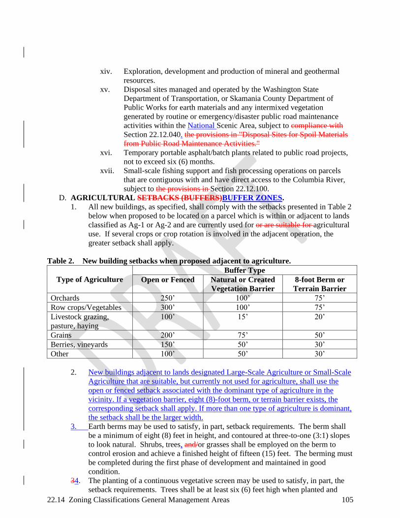
22.14 Zoning Classifications General Management Areas 105
xiv. Exploration, development and production of mineral and geothermal
resources.
xv. Disposal sites managed and operated by the Washington State
Department of Transportation, or Skamania County Department of
Public Works for earth materials and any intermixed vegetation
generated by routine or emergency/disaster public road maintenance
activities within the National Scenic Area, subject to compliance with
Section 22.12.040. the provisions in "Disposal Sites for Spoil Materials
from Public Road Maintenance Activities."
xvi. Temporary portable asphalt/batch plants related to public road projects,
not to exceed six (6) months.
xvii. Small-scale fishing support and fish processing operations on parcels
that are contiguous with and have direct access to the Columbia River,
subject to the provisions in Section 22.12.100.
D. AGRICULTURAL SETBACKS (BUFFERS)BUFFER ZONES.
1. All new buildings, as specified, shall comply with the setbacks presented in Table 2
below when proposed to be located on a parcel which is within or adjacent to lands
classified as Ag-1 or Ag-2 and are currently used for or are suitable for agricultural
use. If several crops or crop rotation is involved in the adjacent operation, the
greater setback shall apply.
Table 2. New building setbacks when proposed adjacent to agriculture.
Type of Agriculture
Buffer Type
Open or Fenced Natural or Created
Vegetation Barrier
8-foot Berm or
Terrain Barrier
Orchards 250’ 100’ 75’
Row crops/Vegetables 300’ 100’ 75’
Livestock grazing,
pasture, haying
100’ 15’ 20’
Grains 200’ 75’ 50’
Berries, vineyards 150’ 50’ 30’
Other 100’ 50’ 30’
2. New buildings adjacent to lands designated Large-Scale Agriculture or Small-Scale
Agriculture that are suitable, but currently not used for agriculture, shall use the
open or fenced setback associated with the dominant type of agriculture in the
vicinity. If a vegetation barrier, eight (8)-foot berm, or terrain barrier exists, the
corresponding setback shall apply. If more than one type of agriculture is dominant,
the setback shall be the larger width.
3. Earth berms may be used to satisfy, in part, setback requirements. The berm shall
be a minimum of eight (8) feet in height, and contoured at three-to-one (3:1) slopes
to look natural. Shrubs, trees, and/or grasses shall be employed on the berm to
control erosion and achieve a finished height of fifteen (15) feet. The berming must
be completed during the first phase of development and maintained in good
condition.
34. The planting of a continuous vegetative screen may be used to satisfy, in part, the
setback requirements. Trees shall be at least six (6) feet high when planted and

22.14 Zoning Classifications General Management Areas 106
reach an ultimate height of at least fifteen (15) feet. The vegetation screen shall be
planted along the appropriate parcel line(s), and be continuous. The vegetative
screening must completely planted during the first phase of development and
maintained in good condition.
45. Variances to the setback requirements set out above may be granted pursuant to
Section 22.06.040.
22.14.030 COMMERCIAL FOREST (F-1)
A. FIRE SAFETY PROVISIONS.
1. All buildings shall be surrounded by a maintained defensible space fuel break of at
least fifty (50) feet. Irrigated or fire resistantfire-resistant vegetation may be planted
within the fuel break, including green lawns and low shrubs (less than twenty-four
(24) inches in height). Trees should be placed greater than fifteen (15) feet between
the crowns and pruned to remove dead and low (less than eight (8) feet) branches.
Accumulated leaves, needles and other dead vegetation shall be removed from
beneath trees. Fuel breaks shall be adjusted to account for site slope, to protect
riparian vegetation and other resources, or as recommended by local fire districts,
conservation districts, or other professional.
2. Hazardous fuels shall be removed within the fuel break area.
3. Buildings with plumbed water systems shall install at least one (1) standpipe at a
minimum of fifty (50) feet from the structure(s).
4. A pond, stream, tank or sump with storage of not less than 1,000 gallons, or a well
or water system capable of delivering twenty (20) gallons per minute shall be
provided. If a well pump is located on-site, the electrical service shall be separate
from the dwelling.
5. Access drives shall be constructed to a minimum of twelve (12) feet in width and
not exceed a finished grade of twelve percent (12 %). Turnouts shall be provided at
a minimum of every 500 feet and at the building site. Access drives shall be
maintained to a level that is passable to fire equipment. However, variances to road
provisions may be made after consultation with the local fire marshal and the
Washington State Department of Natural Resources.
6. Within one (1) year of the occupancy of a dwelling, the Administrator shall conduct
a review of the development to assure compliance with these this section.
7. Telephone and powerUtility supply shall be underground whenever possible.
8. Roofs of structures should shall be made of fire-resistant materials, such as
fiberglass or asphalt shingle or tile. Roof materials such as cedar shake and shingle
should shall not be used.
9. Any chimney or stovepipe on any structure for use with a wood stove or fireplace
should be equipped with a spark arrestor that includes at least one screened
withscreen no coarser than a quarter (¼)one-eighth (1/8) inch mesh metal screen that
is noncombustible and corrosion resistant and should be equipped with a spark
arrestor.
10. All structural projections such as balconies, decks and roof gables should be built
with fire resistant materials equivalent to that specified in the Uniform International
Building code. Structural projections shall be set back from slopes.

22.14 Zoning Classifications General Management Areas 107
11. Attic openings, soffit vents, foundation louvers or other ventilation openings on
dwellings and accessory structures should be screened with no coarser than a
quarterone-eighth (1/8¼) inch mesh metal screen that is noncombustible and
corrosion resistant.
B. SITING CRITERIA.
1. The approval of new dwellings and new accessory buildings and structures on
forest lands shall comply with the following standards:
a. Dwellings shall be set back at least 200 feet from adjacent properties.
b. Dwellings and accessory buildings and structures shall be sited so that they will
have the least impact on nearby or adjoining forest operations. Clustering or
locating proposed development closer to existing development on adjacent lands
may minimize impacts on nearby or adjacent forest operations.
c. The amount of forest land used to site dwellings, accessory buildings, accessory
structures, access roads and service corridors shall be minimized. This can
include locating new dwellings and structures as close to existing public roads
as possible, thereby minimizing the length of access roads and utility corridors;
or locating the dwelling, access road, and service corridors on portions of the
parcel that are least or poorly suited for forestry. Areas may not be suitable for
forestry because of existing nonforest uses, adjacent dwellings, or land
productivity.
d. Dwellings and accessory buildings and structures should be located on gentle
slopes and in no case on slopes which exceed forty thirty percent (40 30 %).
Dwellings should be set back from slopes
e. Narrow canyons and draws should be avoided.
f. Dwellings and accessory buildings and structures should be located to minimize
the difficulty of gaining access to the structure in case of fire.
g. Dwellings and accessory buildings and structures should be located to make
access roads as short and flat as possible.
h. Variances to the above provisions may be granted consistent with Section
22.06.040.
C. USES ALLOWED OUTRIGHT. The uses listed in Section 22.10.040(A) are allowed
without review.
D. USES ALLOWED THROUGH EXPEDITED DEVELOPMENT REVIEW. The
uses listed in Section 22.10.050 are allowed with review pursuant to the provisions listed
in Section 22.06.140.
E. REVIEW USES.
1. The following uses may be allowed, subject to review by the Administrator for
compliance with all applicable provisions protecting scenic, cultural, natural, and
recreation resources:
a. New cultivation.
b. Agricultural structures, except buildings, in conjunction with agricultural use
including new cultivation, subject to Section 22.14.030(A).
c. Agricultural buildings in conjunction with current agricultural use and, if
applicable, proposed agricultural use that a landowner would initiate within one
year and complete within five (5) years, subject to Section 22.14.030(A) and
subject to Section 22.12.010. "Agricultural Buildings."

22.14 Zoning Classifications General Management Areas 108
d. Accessory structures for an existing or approved dwelling that are not otherwise
allowed outright, eligible for the expedited development review process, or
allowed in Section 22.14.030(E)(1)(e) or Section 22.14.030(E)(1)(f).
e. Accessory building(s) larger than 200 square feet in area or taller than ten (10)
feet in height for a dwelling on any legal parcel less than or equal to ten (10)
acres in size are subject to the standards set forth in Section 22.14.030(A) and
Section 22.14.030(B), and the following additional standards:
i. The combined footprints of all accessory buildings on a single parcel
shall not exceed 1,500 square feet in area. This combined size limit
refers to all accessory buildings on a parcel, including buildings allowed
without review, existing buildings and proposed buildings.
ii. The height of any individual accessory building shall not exceed twenty-
four (24) feet.
f. Accessory building(s) larger than 200 square feet in area or taller than ten (10)
feet in height for a dwelling on any legal parcel larger than ten (10) acres in size
are subject to the standards set forth in Section 22.14.030(A) and Section
22.14.030(B), and the following additional standards:
i. The combined footprints of all accessory buildings on a single parcel
shall not exceed 2,500 square feet in area. This combined size limit
refers to all accessory buildings on a parcel, including buildings allowed
without review, existing buildings and proposed buildings.
ii. The footprint of any individual accessory building shall not exceed
1,500 square feet.
iii. The height of any individual accessory building shall not exceed twenty-
four (24) feet.
g. On parcels with a legally existing dwelling, Tthe temporary placement and
occupancy of a recreational vehicle or manufactureduse of a mobile home in the
case of a family hardship, subject to the standards set forth in Section
22.14.030(A) and Section 22.14.030(B), and subject to Section 22.12.110.
h. Construction, reconstruction or modifications of roads, not in conjunction with
forest use or forest practices.
ih. Resource enhancement projects for the purpose of enhancing scenic, cultural,
recreation and/or natural resources, subject to the provisions in "Resource
Enhancement Projects" (Section 22.12.070). These projects may include new
structures (e.g., fish ladders, sediment barriers) and/or activities (e.g., closing
and revegetating unused roads, recontouring abandoned quarries).
ji. Structures associated with hunting and fishing operations.
kj. Towers and fire stations for forest fire protection.
lk. Temporary onsite structures which are auxiliary to and used during the term of a
particular forest operation. "Auxiliary" means a use or alteration of a structure
or land which provides help or is directly associated with the conduct of a
particular forest practice. An auxiliary structure is located onsite, is temporary
in nature, and is not designed to remain for the forest's entire growth cycle from
planting to harvesting. An auxiliary use is removed when a particular forest
practice has concluded.
ml. Temporary portable facility for the primary processing of forest products grown
on a parcel of land or contiguous land in the same ownership where the facility

22.14 Zoning Classifications General Management Areas 109
is to be located. The facility shall be removed upon completion of the harvest
operation.
nm. Private roads serving a residence on the subject parcel, subject to Section
22.14.030(A) and Section 22.14.030(B).
on. A The temporary placement and occupancy of a recreational vehicle or
manufactured mobile home subject to Section 22.14.030(A) and Section
22.14.030(B), in conjunction with a timber operation, upon a finding that
security personnel are required to protect equipment associated with harvest
operation or the subject forestland from fire. The mobile homerecreational
vehicle or manufactured home must be removed upon completion of the subject
harvest operation or the end of the fire season. Placement is subject to the
approval criteria in Section 22.14.030(A) and (B).
po. Land divisions to facilitate forest management. No resulting parcel may be less
than eighty (80) acres in size.
qp. Recreation development, subject to provisions governing recreational intensity
classes set out in Section 22.24.020(B). of this Title.
rq. Lot line adjustments that would result in the potential to create additional
parcels through subsequent land divisions, subject to the provisions in "Lot Line
Adjustments" (Section 22.08.040).
sr. Additions to existing buildings greater than 200 square feet in area or greater
than the height of the existing building.
ts. Docks and boathouses, subject to the provisions in "Docks and Boathouses"
(Section 22.12.050).
ut. Removal/demolition of structures that are fifty (50) or more years old, including
wells, septic tanks and fuel tanks.
v. One (1) single-family dwelling, subject to Section 22.14.030(A) and Section
22.14.030(B), may be allowed if shown to be in conjunction with and
substantially contributing to the current agricultural use of a farm, upon a
demonstration that:
i. No other dwellings exist on the subject farm or ranch, including all of its
constituent parcels, contiguous or otherwise, which are vacant or currently
occupied by persons not directly engaged in farming or working on the subject
farm or ranch and which could be used as the principal agricultural dwelling;
ii. The farm or ranch upon which the dwelling will be located is currently devoted
to agricultural use, as defined, where the day-to-day activities of one (1) or more
residents of the agricultural dwelling will be principally directed to the
agricultural use of the land. The farm or ranch must meet the income capability
test set out in Section 22.14.030(E)(1)(w)(iii); and
iii. The farm or ranch is a commercial agricultural enterprise as determined by
an evaluation of the following factors:
(1) Size of the entire farm or ranch, including all land in the same ownership;
(2) Type(s) of agricultural uses (crops, livestock) and acreage;
(3) Operational requirements for the particular agricultural use common to area
agricultural operations; and
(4) The farm or ranch, and all its constituent parcels, is capable of producing at
least $40,000 in gross annual income. This determination can be made using the
formula (X)(Y)(Z) = I, where:

22.14 Zoning Classifications General Management Areas 110
(a) X = Average yield of the commodity per acre, or unit of production;
(b) Y = Average price of the commodity;
(c) Z = Total acres suitable for production, or total units of production that can be
sustained, on the subject farm or ranch; and
(d) I = Income capability.
wu. Agricultural labor housing upon a showing that:
i. The proposed housing is necessary and accessory to a current
agricultural use on the subject farm.
ii. The housing shall be seasonal unless it is shown that an additional full-
time dwelling is necessary to the current agricultural use of the subject
farm or ranch unit. Seasonal use shall not exceed nine (9) months.
iii. The housing will be located to minimize the conversion of lands capable
of production of farm crops or livestock and will not force a significant
change in or significantly increase the cost of accepted agricultural
practices employed on nearby lands devoted to agricultural use.
xv. Special uses in historic buildings, subject to the provisions in Section
22.12.120. “Special Uses in Historic Buildings (GMA only).”
y. A second single-family dwelling for a farm operator's relative, subject to
Section 22.14.030(A) and Section 22.14.030(B), provided that all of the
following conditions exist:
i. The dwelling would be occupied by a relative of the agricultural
operator or of the agricultural operator's spouse who will be actively
engaged in the management of the farm or ranch. Relative means
grandparent, grandchild, parent, child, brother or sister.
ii. The dwelling would be located on the same parcel as the dwelling of the
principal operator.
iii. The operation is a commercial enterprise, as determined by an
evaluation of the factors described in provisions Section
22.14.030(E)(1)(w)(iii)(1) and Section 22.14.030(E)(1)(w)(iii)(4).
z. Life estates. A landowner who sells or otherwise transfers real property may
retain a life estate in a dwelling and a tract of land surrounding the dwelling.
The life estate tract shall not be considered a parcel as defined herein. A second
dwelling in conjunction with agricultural use may be allowed, subject to the
resource protection Chapters of this Title and if:
i. The proposed dwelling is in conjunction with agricultural use as set out in
Section 22.14.010(C)(1)(s); and
ii. Upon termination of the life estate, the original or second dwelling shall be
removed.
2. The following uses are subject to review by the Administrator for compliance with
all applicable provisions protecting scenic, cultural, natural, and recreational
resources, and may be allowed if:
a. The use will not interfere seriously with accepted forest or agricultural practices
on nearby lands devoted to resource use;
b. The use will be sited in such a way as to minimize the loss of forest or
agricultural land and to minimize the chance of interference with accepted forest
or agricultural practices on nearby lands;
22.14 Zoning Classifications General Management Areas 111
c. The owners of land that is classified as F-1, F-2, F-3, Ag-1 or Ag-2 that lies
within 500 feet of the perimeter of the subject parcel have been notified of the
land use application and have been given at least ten (10) days to comment prior
to a final decision; and, the use will not significantly increase fire hazard, fire
suppression costs or risks to fire suppression personnel; and
d. Complies with the standards set out in Section 22.14.030(A):
i. Construction, reconstruction, or modification of roads, uUtility facilities,
and railroads necessary for public service upon a showing that:
(1) There is no practicable alternative location with less adverse effect on
agriculture and forest lands and on scenic, cultural, natural and
recreation resources; and
(2) The size is the minimum necessary to provide the service.
ii. Home occupations or cottage industries in existing residential or
accessory structures. See also Section 22.12.060.
iii. Wineries and cideries in conjunction with an on-site viticulturevineyard
or orchard, upon a showing that processing of wine or cider is from
grapes grownfruits harvested on the subject farm or inand the local
region.
iv. Wine or cider sales and /tasting rooms, in conjunction with an on-site
winery or cidery.
v. Agricultural product processing and packaging, upon a showing that the
processing will be limited to products grown primarily on the subject
farm and sized to the subject operation.
vi. Boarding of horses. The Administrator shall make findings on property
characteristics, parcel size and impacts to neighbors, and shall specify
the maximum number of horses based on those findings and the number
of recommended animal equivalent units provided in the guidance
documents by Underwood Conservation District, WSU Extension
Offices and the Natural Resource Conservation Service for the
geographic area the application is located within.
vii. Bed and breakfast inns in single-family dwellings (See also Section
22.12.060), provided that the residence:
(1) Is included in the National Register of Historic Places; or
(2) Is listed on the Washington State Register of Historic Places maintained
by the Washington State Department of Archaeology and Historic
Preservation.
viii. Nonprofit, environmental learning or research facilities.
ix. Expansion of existing nonprofit group camps, retreats, or conference
centers.
x. Temporary portable asphalt/batch plants related to public road projects,
not to exceed six (6) months.
xi. Fruit and produce stands, upon a showing that sales will be limited to
agricultural products raised on the subject farm and other farms in the
local region.
xii. Exploration, development and production of mineral and geothermal
resources.
xiii. Aquaculture.

22.14 Zoning Classifications General Management Areas 112
xiv. Disposal sites managed and operated by the Washington State
Department of Transportation, or Skamania County Department of
Public Works for earth materials and any intermixed vegetation
generated by routine or emergency/disaster public road maintenance
activities within the National Scenic Area, subject to to compliance with
the provisions in "Disposal Sites for Spoil Materials from Public Road
Maintenance Activities" (Section 22.12.040).
22.14.040 LARGE WOODLAND (F-2) ZONE
A. FIRE SAFETY PROVISIONS.
1. All buildings shall be surrounded by a maintained defensible space fuel break of at
least fifty (50) feet. Irrigated or fire resistantfire-resistant vegetation may be
planted within the fuel break, including green lawns and low shrubs (less than
twenty-four (24) inches in height). Trees should be placed greater than fifteen (15)
feet between the crowns and pruned to remove dead and low (less than eight (8)
feet) branches. Accumulated leaves, needles and other dead vegetation shall be
removed from beneath trees. Fuel breaks shall be adjusted to account for site slope,
to protect riparian vegetation and other resources, or as recommended by local fire
districts, conservation districts, or other professional.
2. Hazardous fuels shall be removed within the fuel break area.
3. Buildings with plumbed water systems shall install at least one (1) standpipe at a
minimum of fifty (50) feet from the structure(s).
4. A pond, stream, tank or sump with storage of not less than 1,000 gallons, or a well
or water system capable of delivering twenty (20) gallons per minute shall be
provided. If a well pump is located on-site, the electrical service shall be separate
from the dwelling.
5. Access drives shall be constructed to a minimum of twelve (12) feet in width and
not exceed a grade of twelve percent (12 %). Turnouts shall be provided at a
minimum of every 500 feet and at the building site. Access drives shall be
maintained to a level that is passable to fire equipment. However, variances to road
provisions may be made after consultation with the local fire marshal and the
Washington State Department of Natural Resources.
6. Within one (1) year of the occupancy of a dwelling, the Administrator shall conduct
a review of the development to assure compliance with these this section.
7. Telephone and powerUtility supply shall be underground whenever possible.
8. Roofs of structures shallshould be made of fire-resistant materials, such as
fiberglass or asphalt shingle or tile. Roof materials such as cedar shake and shingle
shallshould not be used.
9. Any chimney or stovepipe on any structure for use with a wood stove or fireplace
should be equipped with a spark arrestor that includes at least one screen screened
with no coarser than a quarterone-eighth (¼) (1/8) inch mesh metal screen that is
noncombustible and corrosion resistant and should be equipped with a spark
arrestor.
10. All structural projections such as balconies, decks and roof gables should be built
with fire resistant materials equivalent to that specified in the Uniform International
Building Ccode. Structural projections shall be set back from slopes.

22.14 Zoning Classifications General Management Areas 113
11. Attic openings, soffit vents, foundation louvers or other ventilation openings on
dwellings and accessory structures should be screened with no coarser than quarter
one-eighth (¼) (1/8) inch mesh metal screen that is noncombustible and corrosion
resistant.
B. SITING CRITERIA.
1. The approval of new dwellings and new accessory buildings and structures on
forest lands shall comply with the following standards:
a. Dwellings shall be set back at least 200 feet from adjacent properties.
b. Dwellings and accessory buildings and structures shall be sited so that they will
have the least impact on nearby or adjoining forest operations. Clustering or
locating proposed development closer to existing development on adjacent lands
may minimize impacts on nearby or adjacent forest operations.
c. The amount of forest land used to site dwellings, accessory buildings, accessory
structures, access roads and service corridors shall be minimized. This can
include locating new dwellings and structures as close to existing public roads
as possible, thereby minimizing the length of access roads and utility corridors;
or locating the dwelling, access road, and service corridors on portions of the
parcel that are least or poorly suited for forestry. Areas may not be suitable for
forestry because of existing nonforest uses, adjacent dwellings, or land
productivity.
d. Dwellings and accessory buildings and structures should be located on gentle
slopes and in no case on slopes which exceed forty thirty percent (40 30 %).
Dwellings should be set back from slopes.
e. Narrow canyons and draws should be avoided.
f. Dwellings and accessory buildings and structures should be located to minimize
the difficulty of gaining access to the structure in case of fire.
g. Dwellings and accessory buildings and structures should be located to make
access roads as short and flat as possible.
h. Variances to the above provisions may be granted consistent with Section
22.06.040.
C. USES ALLOWED OUTRIGHT. The uses listed in Section 22.10.040(A) are allowed
without review.
D. USES ALLOWED THROUGH EXPEDITED DEVELOPMENT REVIEW. The
uses listed in Section 22.10.050 are allowed with review pursuant to the provisions listed
in 22.06.140.
E. REVIEW USES.
1. The following uses may be allowed, subject to review by the Administrator for
compliance with all applicable provisions protecting scenic, cultural, natural, and
recreation resources:
a. New cultivation.
b. Agricultural structures, except buildings, in conjunction with agricultural use
including new cultivation, subject to Section 22.14.040(A).
c. Agricultural buildings in conjunction with current agricultural use and, if
applicable, proposed agricultural use that a landowner would initiate within one
year and complete within five years, subject to Section 22.14.040(A) and
subject to Section 22.12.010. "Agricultural Buildings."

22.14 Zoning Classifications General Management Areas 114
d. Accessory structures for an existing or approved dwelling that are not otherwise
allowed outright, eligible for the expedited development review process, or
allowed in Section 22.14.040(E)(1)(e) or Section 22.14.040(E)(1)(f).
e. Accessory building(s) larger than 200 square feet in area or taller than ten (10)
feet in height for a dwelling on any legal parcel less than or equal to ten (10)
acres in size are subject to the standards set forth in Section 22.14.040(A) and
Section 22.14.040(B), and the following additional standards:
i. The combined footprints of all accessory buildings on a single parcel
shall not exceed 1,500 square feet in area. This combined size limit
refers to all accessory buildings on a parcel, including buildings allowed
without review, existing buildings and proposed buildings.
ii. The height of any individual accessory building shall not exceed twenty-
four (24) feet.
f. Accessory building(s) larger than 200 square feet in area or taller than ten (10)
feet in height for a dwelling on any legal parcel larger than ten (10) acres in size
are subject to the standards set forth in Section 22.14.040(A) and Section
22.14.040(B), and the following additional standards:
i. The combined footprints of all accessory buildings on a single parcel
shall not exceed 2,500 square feet in area. This combined size limit
refers to all accessory buildings on a parcel, including buildings allowed
without review, existing buildings and proposed buildings.
ii. The footprint of any individual accessory building shall not exceed
1,500 square feet.
iii. The height of any individual accessory building shall not exceed twenty-
four (24) feet.
g. On parcels with a legally existing dwelling, the temporary placement and
occupancy of a recreational vehicle or manufactured The temporary use of a
mobile home in the case of a family hardship, subject to the standards set forth
in Section 22.14.040(A) and Section 22.14.040(B), and subject to Section
22.12.110.
h. Construction, reconstruction or modifications of roads, not in conjunction with
forest use or forest practices.
ih. Resource enhancement projects for the purpose of enhancing scenic, cultural,
recreation and/or natural resources, subject to the provisions in "Resource
Enhancement Projects" (Section 22.12.070). These projects may include new
structures (e.g., fish ladders, sediment barriers) and/or activities (e.g., closing
and revegetating unused roads, recontouring abandoned quarries).
ji. Structures associated with hunting and fishing operations.
kj. Towers and fire stations for forest fire protection.
lk. Temporary onsite structures which are auxiliary to and used during the term of a
particular forest operation. "Auxiliary" means a use or alteration of a structure
or land which provides help or is directly associated with the conduct of a
particular forest practice. An auxiliary structure is located onsite, is temporary
in nature, and is not designed to remain for the forest's entire growth cycle from
planting to harvesting. An auxiliary use is removed when a particular forest
practice has concluded.
22.14 Zoning Classifications General Management Areas 115
ml. Temporary portable facility for the primary processing of forest products grown
on a parcel of land or contiguous land in the same ownership where the facility
is to be located. The facility shall be removed upon completion of the harvest
operation.
nm. Private roads serving a residence on the subject parcel, subject to Section
22.14.040(A) and Section 22.14.040(B).
on. Land divisions to facilitate forest management. No resulting parcel may be less
than eighty (80) acres in size.
q. Life estates. A landowner who sells or otherwise transfers real property may
retain a life estate in a dwelling and a tract of land surrounding the dwelling.
The life estate tract shall not be considered a parcel as defined herein. A second
dwelling in conjunction with agricultural use may be allowed, subject to the
resource protection Chapters of this Title and if:
i. The proposed dwelling is in conjunction with agricultural use as set out in
Section 22.14.010(C)(1)(s); and
ii. Upon termination of the life estate, the original or second dwelling shall be
removed.
r.o. Recreation development, subject to provisions governing recreational intensity
classes set out in Section 22.24.020(B). of this Title.
s.p. Lot line adjustments that would result in the potential to create additional
parcels through subsequent land divisions, subject to the provisions in "Lot Line
Adjustments" (Section 22.08.040).
t.q. Additions to existing buildings greater than 200 square feet in area or greater
than the height of the existing building.
u.r. Docks and boathouses, subject to the provisions in "Docks and Boathouses"
(Section 22.12.050).
v.s. Removal/demolition of structures that are fifty (50) or more years old, including
wells, septic tanks and fuel tanks.
w.t.Commercial events, subject to Section 22.12.030.
x. One (1) single-family dwelling, subject to Section 22.14.040(A) and Section
22.14.040(B), may be allowed if shown to be in conjunction with and
substantially contributing to the current agricultural use of a farm, upon a
demonstration that:
i. No other dwellings exist on the subject farm or ranch, including all of its
constituent parcels, contiguous or otherwise, which are vacant or
currently occupied by persons not directly engaged in farming or
working on the subject farm or ranch and which could be used as the
principal agricultural dwelling;
ii. The farm or ranch upon which the dwelling will be located is currently
devoted to agricultural use, as defined, where the day-to-day activities of
one or more residents of the agricultural dwelling will be principally
directed to the agricultural use of the land. The farm or ranch must meet
the income capability test set out in Section 22.14.040(E)(1)(x)(iii); and
iii. The farm or ranch is a commercial agricultural enterprise as determined
by an evaluation of the following factors:
(1) Size of the entire farm or ranch, including all land in the same
ownership;
22.14 Zoning Classifications General Management Areas 116
(2) Type(s) of agricultural uses (crops, livestock) and acreage;
(3) Operational requirements for the particular agricultural use common to
area agricultural operations; and
(4) The farm or ranch, and all its constituent parcels, is capable of producing
at least $40,000 in gross annual income. This determination can be made
using the formula (X)(Y)(Z) = I, where:
(a) X = Average yield of the commodity per acre, or unit of production;
(b) Y = Average price of the commodity;
(c) Z = Total acres suitable for production, or total units of production
that can be sustained, on the subject farm or ranch; and
(d) I = Income capability.
uy. Agricultural labor housing upon a showing that:
i. The proposed housing is necessary and accessory to a current
agricultural use on the subject farm.
ii. The housing shall be seasonal unless it is shown that an additional full-
time dwelling is necessary to the current agricultural use of the subject
farm or ranch unit. Seasonal use shall not exceed nine (9) months.
iii. The housing will be located to minimize the conversion of lands capable
of production of farm crops or livestock and will not force a significant
change in or significantly increase the cost of accepted agricultural
practices employed on nearby lands devoted to agricultural use.
z. A second single-family dwelling for a farm operator's relative, subject to
Section 22.14.040(A) and Section 22.14.040(B), provided that all of the
following conditions exist:
i. The dwelling would be occupied by a relative of the agricultural operator or of
the agricultural operator's spouse who will be actively engaged in the
management of the farm or ranch. Relative means grandparent, grandchild,
parent, child, brother or sister.
ii. The dwelling would be located on the same parcel as the dwelling of the
principal operator.
iii. The operation is a commercial enterprise, as determined by an evaluation
of the factors described in provisions Section 22.14.040(E)(1)(x)(iii)(1) through
Section 22.14.040(E)(1)(x)(iii)(4).
aa. One (1) single family dwelling, subject to Section 22.14.040(A) and Section
22.14.040(B) upon demonstration that all of the following conditions exist:
i. The dwelling will contribute substantially to the growing, propagation and
harvesting of forest tree species. The principal purpose for locating a dwelling
on lands designated F-2 is to enable the resident to conduct efficient and
effective forest management. This requirement indicates a relationship between
ongoing forest management and the location of a dwelling on the subject parcel.
A dwelling may not always be required for forest management;
ii. The parcel has been enrolled in the state's forest assessment program.
iii. A forest management plan has been prepared in conjunction with the
state's forest assessment program and approved by the appropriate local board
or agency. The plan must indicate the condition and productivity of lands to be
managed; the operations the owner will carry out (thinning, harvest, planning,
etc.); a chronological description of when the operations will occur; estimates of

22.14 Zoning Classifications General Management Areas 117
yield, labor and expenses; and how the dwelling will contribute toward the
successful completion of the operations.
iv. No other dwellings exist on the parcel which are vacant or currently
occupied by persons not engaged in forestry, which could be used as the
principal forest dwelling.
v. A declaration has been signed by the landowner and recorded in the County
Auditor's records specifying that the owners, successors, heirs and assigns of the
subject parcel are aware that adjacent and nearby operators are entitled to carry
on accepted farm or forest practices on lands designated Ag-1, Ag-2, F-1, F-2
and F-3.
bbv. Special uses in historic buildings, subject to the provisions in Section
22.12.120. “Special uses in Historic Buildings (GMA only).”
2. The following uses are subject to review by the Administrator for compliance with
all applicable provisions protecting scenic, cultural, natural, and recreational
resources, and may be allowed if:
a. The use will not interfere seriously with accepted forest or agricultural practices
on nearby lands devoted to resource use;
b. The use will be sited in such a way as to minimize the loss of forest or
agricultural land and to minimize the chance of interference with accepted forest
or agricultural practices on nearby lands;
c. The owners of land that is classified as F-1, F-2, F-3, Ag-1 or Ag-2 that lies
within 500 feet of the perimeter of the subject parcel have been notified of the
land use application and have been given at least ten (10) days to comment prior
to a final decision; and
d. The use will not significantly increase fire hazard, fire suppression costs or risks
to fire suppression personnel and complies with the standards set out in Section
22.14.040(A):
i. Construction, reconstruction, or modifications of roads, Uutility
facilities, and railroads necessary for public service upon a showing that:
(1) There is no practicable alternative location with less adverse effect on
agriculture and forest lands and on scenic, cultural, natural and
recreation resources; and
(2) The size is the minimum necessary to provide the service.
ii. Home occupations or cottage industries in existing residential or
accessory structures. See also Section 22.12.060.
iii. Wineries and cideries in conjunction with an on-site viticulturevineyard
or orchard, upon a showing that processing of wine or cider is from
grapes grownfruits harvested on the subject farm or inand the local
region.
iv. Wine or cider sales and /tasting rooms, in conjunction with an on-site
winery or cidery.
v. Agricultural product processing and packaging, upon a showing that the
processing will be limited to products grown primarily on the subject
farm and sized to the subject operation.
vi. Boarding of horses. The Administrator shall make findings on property
characteristics, parcel size and impacts to neighbors, and shall specify
the maximum number of horses based on those findings and the number

22.14 Zoning Classifications General Management Areas 118
of recommended animal equivalent units provided in the guidance
documents by Underwood Conservation District, WSU Extension
Offices and the Natural Resource Conservation Service for the
geographic area the application is located within.
vii. Bed and breakfast inns in single-family dwellings (See also Section
22.12.020), provided that the residence:
(1) Is included in the National Register of Historic Places; or
(2) Is listed on the Washington State Register of Historic Places maintained
by the Washington State Department of Archaeology and Historic
Preservation.
viii. Nonprofit, environmental learning or research facilities.
ix. Expansion of existing nonprofit group camps, retreats, or conference
centers.
x. Temporary portable asphalt/batch plants related to public road projects,
not to exceed six months.
xi. Fruit and produce stands, upon a showing that sales will be limited to
agricultural products raised on the subject farm and other farms in the
local region.
xii. Exploration, development and production of mineral and geothermal
resources.
xiii. Aquaculture.
xiv. Disposal sites managed and operated by the Washington State
Department of Transportation, or Skamania County Department of
Public Works for earth materials and any intermixed vegetation
generated by routine or emergency/disaster public road maintenance
activities within the National Scenic Area, subject to compliance with
the provisions in "Disposal Sites for Spoil Materials from Public Road
Maintenance Activities" (Section 22.12.040).
22.14.050 SMALL WOODLAND (F-3) ZONE
A. FIRE SAFETY PROVISIONS.
1. All buildings shall be surrounded by a maintained defensible space fuel break of at
least fifty (50) feet. Irrigated or fire resistantfire-resistant vegetation may be
planted within the fuel break, including green lawns and low shrubs (less than
twenty-four (24) inches in height). Trees should be placed greater than fifteen (15)
feet between the crowns and pruned to remove dead and low (less than eight (8)
feet) branches. Accumulated leaves, needles and other dead vegetation shall be
removed from beneath trees. Fuel breaks shall be adjusted to account for site slope,
to protect riparian vegetation and other resources, or as recommended by local fire
districts, conservation districts, or other professional.
2. Hazardous fuels shall be removed within the fuel break area.
3. Buildings with plumbed water systems shall install at least one (1) standpipe at a
minimum of fifty (50) feet from the structure(s).
4. A pond, stream, tank or sump with storage of not less than 1,000 gallons, or a well
or water system capable of delivering twenty (20) gallons per minute shall be

22.14 Zoning Classifications General Management Areas 119
provided. If a well pump is located on-site, the electrical service shall be separate
from the dwelling.
5. Access drives shall be constructed to a minimum of twelve (12) feet in width and
not exceed a finished grade of twelve percent (12%). Turnouts shall be provided at
a minimum of every 500 feet and at the building site. Access drives shall be
maintained to a level that is passable to fire equipment. However, variances to road
provisions may be made after consultation with the local fire marshal and the
Washington State Department of Natural Resources.
6. Within one (1) year of the occupancy of a dwelling, the Administrator shall conduct
a review of the development to assure compliance with these this section.
7. Telephone and powerUtility supply shall be underground whenever possible.
8. Roofs of structures should shall be made of fire-resistant materials, such as
fiberglass or asphalt shingle or tile. Roof materials such as cedar shake and shingle
should shall not be used.
9. Any chimney or stovepipe on any structure for use with a wood stove or fireplace
should be equipped with a spark arrestor that includes at least one screen screened
with no coarser than a quarterone-eighth (¼) (1/8) inch mesh metal screen that is
noncombustible and corrosion resistant and should be equipped with a spark
arrestor.
10. All structural projections such as balconies, decks and roof gables should be built
with fire resistant materials equivalent to that specified in the Uniform International
Building Ccode. Structural projections shall be set back from slopes.
11. Attic openings, soffit vents, foundation louvers or other ventilation openings on
dwellings and accessory structures should be screened with no coarser than a
quarterone-eighth (¼) (1/8) inch mesh metal screen that is noncombustible and
corrosion resistant.
B. SITING CRITERIA. The approval of new dwellings and new accessory buildings and
structures on forest lands shall comply with the following standards:
1. Dwellings shall be set back at least 200 feet from adjacent properties.
2. Dwellings and accessory buildings and structures shall be sited so that they will
have the least impact on nearby or adjoining forest operations. Clustering or
locating proposed development closer to existing development on adjacent lands
may minimize impacts on nearby or adjacent forest operations.
3. The amount of forest land used to site dwellings, accessory buildings, accessory
structures, access roads and service corridors shall be minimized. This can include
locating new dwellings and structures as close to existing public roads as possible,
thereby minimizing the length of access roads and utility corridors; or locating the
dwelling, access road, and service corridors on portions of the parcel that are least
or poorly suited for forestry. Areas may not be suitable for forestry because of
existing nonforest uses, adjacent dwellings, or land productivity.
4. Dwellings and accessory buildings and structures should be located on gentle slopes
and in no case on slopes which exceed forty thirty percent (40 30 %). Dwellings
should be set back from slopes.
5. Narrow canyons and draws should be avoided.
6. Dwellings and accessory buildings and structures should be located to minimize the
difficulty of gaining access to the structure in case of fire.
22.14 Zoning Classifications General Management Areas 120
7. Dwellings and accessory buildings and structures should be located to make access
roads as short and flat as possible.
8. Variances to the above provisions may be granted consistent with Section
22.06.040.
C. USES ALLOWED OUTRIGHT. The uses listed in Section 22.10.040(A) are allowed
without review.
D. USES ALLOWED THROUGH EXPEDITED DEVELOPMENT REVIEW. The
uses listed in Section 22.10.050 are allowed with review pursuant to the provisions listed
in 22.06.140.
E. REVIEW USES.
1. The following uses may be allowed, subject to review by the Administrator for
compliance with all applicable provisions protecting scenic, cultural, natural, and
recreation resources:
a. New cultivation.
b. Agricultural structures, except buildings, in conjunction with agricultural use
including new cultivation, subject to Section 22.14.050(A).
c. Agricultural buildings in conjunction with current agricultural use and, if
applicable, proposed agricultural use that a landowner would initiate within one
year and complete within five years, subject to Section 22.14.050(A) and
subject to Section 22.12.010. "Agricultural Buildings."
d. Accessory structures for an existing or approved dwelling that are not otherwise
allowed outright, eligible for the expedited development review process, or
allowed in Section 22.14.050(E)(1)(e) or Section 22.14.050(E)(1)(f).
e. Accessory building(s) larger than 200 square feet in area or taller than ten (10)
feet in height for a dwelling on any legal parcel less than or equal to ten (10)
acres in size are subject to the standards set forth in Section 22.14.050(A) and
Section 22.14.050(B), and the following additional standards:
i. The combined footprints of all accessory buildings on a single parcel
shall not exceed 1,500 square feet in area. This combined size limit
refers to all accessory buildings on a parcel, including buildings allowed
without review, existing buildings and proposed buildings.
ii. The height of any individual accessory building shall not exceed twenty-
four (24) feet.
f. Accessory building(s) larger than 200 square feet in area or taller than ten (10)
feet in height for a dwelling on any legal parcel larger than ten (10) acres in size
are subject to the standards set forth in Section 22.14.050(A) and Section
22.14.050(B), and the following additional standards:
i. The combined footprints of all accessory buildings on a single parcel
shall not exceed 2,500 square feet in area. This combined size limit
refers to all accessory buildings on a parcel, including buildings allowed
without review, existing buildings and proposed buildings.
ii. The footprint of any individual accessory building shall not exceed
1,500 square feet.
iii. The height of any individual accessory building shall not exceed twenty-
four (24) feet.
g. The temporary placement and occupancy of a recreational vehicle or
manufactured use of a mobile home in the case of a family hardship, subject to
22.14 Zoning Classifications General Management Areas 121
the standards set forth in Section 22.14.050(A) and Section 22.14.050(B), and
subject to Section 22.12.110.
h. Construction, reconstruction or modifications of roads, not in conjunction with
forest use or forest practices.
i. Resource enhancement projects for the purpose of enhancing scenic, cultural,
recreation and/or natural resources, subject to the provisions in "Resource
Enhancement Projects" (Section 22.12.070). These projects may include new
structures (e.g., fish ladders, sediment barriers) and/or activities (e.g., closing
and revegetating unused roads, recontouring abandoned quarries).
j. Structures associated with hunting and fishing operations.
k. Towers and fire stations for forest fire protection.
l. Temporary onsite structures which are auxiliary to and used during the term of a
particular forest operation. "Auxiliary" means a use or alteration of a structure
or land which provides help or is directly associated with the conduct of a
particular forest practice. An auxiliary structure is located onsite, is temporary
in nature, and is not designed to remain for the forest's entire growth cycle from
planting to harvesting. An auxiliary use is removed when a particular forest
practice has concluded.
m. Temporary portable facility for the primary processing of forest products grown
on a parcel of land or contiguous land in the same ownership where the facility
is to be located. The facility shall be removed upon completion of the harvest
operation.
n. Private roads serving a residence on the subject parcel, subject to Section
22.14.050(A) and Section 22.14.050(B).
o. Land divisions, subject to the minimum lot size requirements in Section
22.10.060.
p. Land division, known as Cluster Development subject to Section 22.08.030, and
provided that this provision will only apply to parcels that are currently at least
double the required minimum lot size. For example, if the minimum lot size is
forty (40) acres, then this provision shall only apply if the parcel is at least
eighty (80) acres in size.
pq. Life estates. A landowner who sells or otherwise transfers real property may
retain a life estate in a dwelling and a tract of land surrounding the dwelling.
The life estate tract shall not be considered a parcel as defined herein. A second
dwelling in conjunction with agricultural use may be allowed, subject to the
resource protection Chapters 22.18 through 22.24 of this Title and if:
i. The proposed dwelling is in conjunction with agricultural use as set out
in Section 22.14.010(C)(1)(rs); and
ii. Upon termination of the life estate, the original or second dwelling shall
be removed.
r.q. Recreation development, subject to provisions governing recreational intensity
classes set out in Section 22.24.020(B) of this Title.
s.r. Lot line adjustments that would result in the potential to create additional
parcels through subsequent land divisions, subject to the provisions in "Lot Line
Adjustments" (Section 22.08.040).
t.s. Additions to existing buildings greater than 200 square feet in area or
greater than the height of the existing building.

22.14 Zoning Classifications General Management Areas 122
u.t. Docks and boathouses, subject to the provisions in "Docks and Boathouses"
(Section 22.12.050).
v.u. Removal/demolition of structures that are fifty (50) or more years old,
including wells, septic tanks and fuel tanks.
w.v. Commercial events, subject to Section 22.12.030.
xw. Agricultural labor housing upon a showing that:
i. The proposed housing is necessary and accessory to a current
agricultural use on the subject farm.
ii. The housing shall be seasonal unless it is shown that an additional full-
time dwelling is necessary to the current agricultural use of the subject
farm or ranch unit. Seasonal use shall not exceed nine months.
iii. The housing will be located to minimize the conversion of lands capable
of production of farm crops or livestock and will not force a significant
change in or significantly increase the cost of accepted agricultural
practices employed on nearby lands devoted to agricultural use.
xy. A second single-family dwelling for a farm operator's relative, subject to
Section 22.14.050(A) and Section 22.14.050(B), provided that all of the
following conditions exist:
i. The dwelling would be occupied by a relative of the agricultural
operator or of the agricultural operator's spouse who will be actively
engaged in the management of the farm or ranch. Relative means
grandparent, grandchild, parent, child, brother or sister.
ii. The dwelling would be located on the same parcel as the dwelling of the
principal operator.
iii. The operation is a commercial enterprise, as determined by an
evaluation of the factors described in Section 22.14.010(C)(1)(rs)(iii).
zy. One (1) single-family dwelling on a legally created and existing parcel upon the
parcel’s enrollment in the Forest Tax Classification Program. Upon showing
that a parcel cannot qualify, a parcel is entitled to one (1) single-family
dwelling. In either case, the location of a dwelling shall comply with Section
22.14.050(A) and Section 22.14.050(B). A declaration shall be signed by the
landowner and recorded in the Auditor’s Records specifying that the owners,
successors, heirs, and assigns of the subject parcel are aware that adjacent and
nearby operators are entitled to carry on accepted farm and forest practices on
lands classified as F-1, F-2, F-3, Ag-1 and Ag-2.
aaz. Special uses in historic buildings, subject to the provisions in Section
22.12.120. “Special Uses in Historic Buildings (GMA only).”
2. The following uses are subject to review by the Administrator for compliance with
all applicable provisions protecting scenic, cultural, natural, and recreational
resources, and may be allowed if:
a. The use will not interfere seriously with accepted forest or agricultural practices
on nearby lands devoted to resource use;
b. The use will be sited in such a way as to minimize the loss of forest or
agricultural land and to minimize the chance of interference with accepted forest
or agricultural practices on nearby lands;
c. The owners of land that is classified as F-1, F-2, F-3, Ag-1 or Ag-2 that lies
within 500 feet of the perimeter of the subject parcel have been notified of the
22.14 Zoning Classifications General Management Areas 123
land use application and have been given at least ten (10) days to comment prior
to a final decision; and
d. The use will not significantly increase fire hazard, fire suppression costs or risks
to fire suppression personnel and complies with the standards set out in Section
22.14.050(A):
i. Construction, reconstruction, or modification of roads, Uutility facilities,
and railroads necessary for public service upon a showing that:
(1) There is no practicable alternative location with less adverse effect on
agriculture and forest lands and on scenic, cultural, natural and
recreation resources; and
(2) The size is the minimum necessary to provide the service.
ii. Home occupations or cottage industries in existing residential or
accessory structures. See also Section 22.12.060.
iii. i. Wineries and cideries in conjunction with an on-site viticulturevineyard
or orchard, upon a showing that processing of wine or cider is from
grapes grownfruit harvested on the subject farm or inand the local
region.
iv. ii. Wine or cider sales /tastingand tasting rooms, in conjunction with an on-
site winery or cidery.
v. iii. Agricultural product processing and packaging, upon a showing that the
processing will be limited to products grown primarily on the subject
farm and sized to the subject operation.
vi. iv. Boarding of horses. The Administrator shall make findings on
property characteristics, parcel size and impacts to neighbors, and shall
specify the maximum number of horses based on those findings and the
number of recommended animal equivalent units provided in the
guidance documents by Underwood Conservation District, WSU
Extension Offices and the Natural Resource Conservation Service for
the geographic area the application is located within.
vii. v. Bed and breakfast inns in single-family dwellings (See also
Section 22.12.020), provided that the residence:
(3) Is included in the National Register of Historic Places; or
(4) Is listed on the Washington State Register of Historic Places maintained
by the Washington State Department of Archaeology and Historic
Preservation.
viii. vi. Nonprofit, environmental learning or research facilities.
ix. vii. Expansion of existing nonprofit group camps, retreats, or
conference centers.
x. viii. Temporary portable asphalt/batch plants related to public road
projects, not to exceed six (6) months.
xi. ix. Fruit and produce stands, upon a showing that sales will be limited
to agricultural products raised on the subject farm and other farms in the
local region.
xii. x. Exploration, development and production of mineral and
geothermal resources.
xiii. xi. Aquaculture.

22.14 Zoning Classifications General Management Areas 124
xiv. xii. Disposal sites managed and operated by the Washington State
Department of Transportation, or Skamania County Department of
Public Works for earth materials and any intermixed vegetation
generated by routine or emergency/disaster public road maintenance
activities within the National Scenic Area, subject to compliance with
the provisions in "Disposal Sites for Spoil Materials from Public Road
Maintenance Activities" (Section 22.12.040).
xv. xiii. Small-scale fishing support and fish processing operations on
parcels that are contiguous with and have direct access to the Columbia
River, subject to Section 22.12.100.
22.14.060 RESIDENTIAL ZONES
A. ZONES.
1. Residential (R-1)
2. Residential (R-2)
3. Residential (R-5)
4. Residential (R-10)
B. USES ALLOWED OUTRIGHT. The uses listed in Section 22.10.040(A) are allowed
without review.
C. USES ALLOWED THROUGH EXPEDITED DEVELOPMENT REVIEW. The
uses listed in Section 22.10.050 are allowed with review pursuant to the provisions listed
in 22.06.140.
D. REVIEW USES.
1. The following uses may be allowed, subject to review by the Administrator for
compliance with all applicable provisions protecting scenic, cultural, natural, and
recreation resources:
a. One (1) single-family dwelling per legally created and existing parcel. If the
parcel is adjacent to lands designated Ag-1, Ag-2, F-1, F-2 or F-3, then
placement of the dwelling shall comply with the buffer and notice requirements
in Sections 22.14.010(D), 22.14.020(D), 22.14.030(B), 22.14.040(B), or
22.14.050(B). If the parcel is adjacent to lands designated F-1, F-2 or F-3, then
the requirements of Sections 22.14.030(B), 22.14.040(B), or 22.14.050(B) shall
also apply.
b. The temporary use placement and occupancy of a recreational vehicle or
manufactured home of a mobile home in the case of a family hardship, subject
to Section 22.12.110.
c. Construction, reconstruction or modifications of roads.
d.c. New cultivation.
e.d. Land divisions, subject to provisions establishing minimum parcel sizes. See
also Section 22.10.060 hereof.
f. Cluster development land divisions on parcels of ten (10) acres or larger in R(5)
zones and on parcels of twenty (20) acres or larger in R(10) zones, subject to
Section 22.08.030.
g.e. Accessory structures for an existing or approved dwelling that are not otherwise
allowed outright, eligible for the expedited development review process, or
allowed in Section 22.14.060(D)(1)(fh).

22.14 Zoning Classifications General Management Areas 125
h.f. Accessory building(s) larger than 200 square feet in area or taller than ten (10)
feet in height for a dwelling on any legal parcel are subject to the following
additional standards:
i. The combined footprints of all accessory buildings on a single parcel
shall not exceed 1,500 square feet in area. This combined size limit
refers to all accessory buildings on a parcel, including buildings allowed
without review, existing buildings and proposed buildings.
ii. The height of any individual accessory building shall not exceed twenty-
four (24) feet.
i.g. Lot line adjustments that would result in the potential to create additional
parcels through subsequent land divisions, subject to the provisions in "Lot Line
Adjustments" (Section 22.08.040).
j.h. Resource enhancement projects for the purpose of enhancing scenic, cultural,
recreation and/or natural resources, subject to the provisions in "Resource
Enhancement Projects" (Section 22.12.070). These projects may include new
structures (e.g., fish ladders, sediment barriers) and/or activities (e.g., closing
and revegetating unused roads, recontouring abandoned quarries).
k.i. Agricultural structures, except buildings, in conjunction with agricultural use,
including new cultivation.
l.j. Agricultural buildings in conjunction with current agricultural use and, if
applicable, proposed agricultural use that a landowner would initiate within one
year and complete within five years, subject to the standards in "Agricultural
Buildings" (Section 22.12.010).
m.k. Additions to existing buildings greater than 200 square feet in area or
greater than the height of the existing building.
n.l. Docks and boathouses, subject to the provisions in "Docks and Boathouses"
(Section 22.12.050).
o.m. Removal/demolition of structures that are fifty (50) or more years old,
including wells, septic tanks and fuel tanks.
p.n.Commercial events, subject to the provisions in "Commercial Events" (Section
22.12.030).
q.o.Special uses in historic buildings, subject to the provisions in Section 22.12.120.
“Special Uses in Historic Buildings (GMA only).”
2. The following uses are subject to review by the Administrator for compliance with
all applicable provisions protecting scenic, cultural, natural, and recreational
resources, and may be allowed if:
a. The use would be compatible with the surrounding area, after considering visual
character of the area, traffic generation, noise, dust and odors;
b. The proposed use will not require public services other than those existing or
approved for the area;
c. If the subject parcel is located within 500 feet of lands designated Ag-1, Ag-2,
F-1, F-2 or F-3, new buildings associated with the proposed use comply with the
buffer provisions set out in Sections 22.14.010(D), 22.14.020(D), 22.14.030(B),
22.14.040(B), or 22.14.050(B); and
d. If the subject parcel is located within 500 feet of lands designated F-1, F-2 or F-
3, new buildings associated with the proposed use comply with the provisions of
Sections 22.14.030(B), 22.14.040(B), or 22.14.050(B):
22.14 Zoning Classifications General Management Areas 126
i. Schools within an existing church or community building.
ii. Construction and reconstruction of roads, uUtility facilities, and
railroads.
iii. Home occupations or cottage industries in an existing residence or
accessory structure. See also Section 22.12.060 hereof.
iv. Fire stations.
v. Recreation development, subject to provisions governing recreational
intensity classes set out in Chapters 22.18 through 22.24 of this Title.
vi. Community parks and playgrounds. consistent with the standards of the
National Park and Recreation Society, regarding the need for such
facilities.
vii. Accredited child carechildcare center on lands designated R-1 or R-2,
and on other designated residential lands if within an existing church or
community building.
viii. Bed and breakfast inns in single family dwellings on lands zoned R-5 or
R-10, subject to Section 22.12.020.
ix. Expansion of existing primary or middle schools on land purchased prior
to June 8, 1999. For purposes of this section, existing schools means
public schools that existed prior to adoption of the original Management
Plan on October 15, 1991.
ix. x. Overnight accommodations in single-family dwellings located on lands
designated Residential (R-5) or Residential (R-10), subject to Section
22.12.140.
x. xi. Wineries and cideries, in conjunction with an onsite viticulturevineyard
or orchard, upon a showing that processing of wine or cider is from
grapes fruits harvestedgrown on the subject farm or inand the local
region.
xi. xii. Wine or cider sales/ and tasting rooms in conjunction with an on-
site winery or cidery, under the following conditions:
(1) The use shall comply with the provisions in "Home Occupations and
Cottage Industries" (Section 22.12.060), with the following exceptions:
(a) The use may employ an unlimited number of outside employees.
(b) The wine or cider sales and /tasting room may include interior and/or
exterior space, provided the combined interior and exterior spaces
shall not exceed 1,000 square feet.
(c) The interior space may be located in an existing building or in a new
building or addition to an existing building constructed for the
primary purpose of housing the wine or cider sales and /tasting
room.
(d) The exterior space may be a veranda, patio, or other similar type of
structure.
xii. xiii. Small-scale fishing support and fish processing operations on
parcels that are contiguous with and have direct access to the Columbia
River, subject to Section 22.12.100.
xiii. xiv. Boarding of horses on lands designated 10-acre Residential. The
Administrator shall make findings on property characteristics, parcel
size and impacts to neighbors, and shall specify the maximum number of

22.14 Zoning Classifications General Management Areas 127
horses based on those findings and the number of recommended animal
equivalent units provided in the guidance documents by Underwood
Conservation District, WSU Extension Offices and the Natural Resource
Conservation Service for the geographic area the application is located
within.
22.14.070 RURAL CENTER ZONE
A. USES ALLOWED OUTRIGHT. The uses listed in Section 22.10.040(A) are allowed
without review.
B. USES ALLOWED THROUGH EXPEDITED DEVELOPMENT REVIEW. The
uses listed in Section 22.10.050 are allowed with review pursuant to the provisions listed
in 22.06.140.
C. REVIEW USES.
1. The following uses may be allowed, subject to review by the Administrator for
compliance with all applicable provisions protecting scenic, cultural, natural, and
recreation resources:
a. One (1) single-family dwelling per legally created and existing parcel.
b. Accessory structures for an existing or approved dwelling that are not otherwise
allowed outright, eligible for the expedited development review process, or
allowed in Section 22.14.070(C)(1)(c).
c. Accessory building(s) larger than 200 square feet in area or taller than ten (10)
feet in height for a dwelling on any legal parcel are subject to the following
additional standards:
i. The combined footprints of all accessory buildings on a single parcel
shall not exceed 1,500 square feet in area. This combined size limit
refers to all accessory buildings on a parcel, including buildings allowed
without review, existing buildings and proposed buildings.
ii. The height of any individual accessory building shall not exceed twenty-
four (24) feet.
d. The temporary placement and occupancy of a recreational vehicle or
manufactured homeuse of a mobile home, subject to Section 22.12.110. hereof.
e. New cultivation.
f. Land divisions subject to provisions establishing minimum parcel sizes. See
also Section 22.10.060.
g. Duplexes.
h. Fire stations.
i. Libraries.
j. Government buildings.
k. Community centers and meeting halls.
l. Schools.
m. Accredited child carechildcare centers.
n. Rural service commercial and tourist commercial uses limited to 5,000 square
feet of floor area per building or use, including the following:
i. Grocery stores.
ii. Variety and hardware stores.
iii. Shops, offices and repair shops.
22.14 Zoning Classifications General Management Areas 128
iv. Personal services such as barber and beauty shops.
v. Travelers accommodations, bBed and breakfast inns.
vi. Restaurants.
vii. Taverns and bars.
viii. Gas stations.
ix. Gift shops.
ix. x. Overnight accommodations.
o. Home occupations or cottage industries in an existing residence or accessory
structure. See Section 22.12.060.
p. Utility facilities, roads, and railroads.
q. Recreation development subject to provisions governing recreational intensity
classes set out in Chapters 22.18 through 22.24 of this Title.
r. Places of worship.
s. Lot line adjustments that would result in the potential to create additional
parcels through subsequent land divisions, subject to the provisions in "Lot Line
Adjustments" (Section 22.08.040).
t. Resource enhancement projects for the purpose of enhancing scenic, cultural,
recreation and/or natural resources, subject to the provisions in "Resource
Enhancement Projects" (Section 22.12.070). These projects may include new
structures (e.g., fish ladders, sediment barriers) and/or activities (e.g., closing
and revegetating unused roads, recontouring abandoned quarries).
u. Agricultural structures, except buildings, in conjunction with agricultural use,
including new cultivation.
v. Agricultural buildings in conjunction with current agricultural use and, if
applicable, proposed agricultural use that a landowner would initiate within one
year and complete within five years, subject to the standards in "Agricultural
Buildings" (Section 22.12.010).
w. Additions to existing buildings greater than 200 square feet in area or greater
than the height of the existing building.
x. Removal/demolition of structures that are fifty (50) or more years old, including
wells, septic tanks and fuel tanks.
y. Commercial events, subject to the provisions in "Commercial Events" (Section
12.030).
z. Special uses in historic buildings, subject to the provisions in Section 22.12.120.
“Special Uses in Historic Buildings (GMA only).”
22.14.080 COMMERCIAL (C) ZONE
A. USES ALLOWED OUTRIGHT. The uses listed in Section 22.10.040(A) are allowed
without review.
B. USES ALLOWED THROUGH EXPEDITED DEVELOPMENT REVIEW. The
uses listed in Section 22.10.050 are allowed with review pursuant to the provisions listed
in 22.06.140.
C. REVIEW USES. The following uses may be allowed, subject to review by the
Administrator for compliance with all applicable provisions protecting scenic, cultural,
natural, and recreation resources if:
1. The proposal is limited to 5,000 square feet of floor area per building or use; and
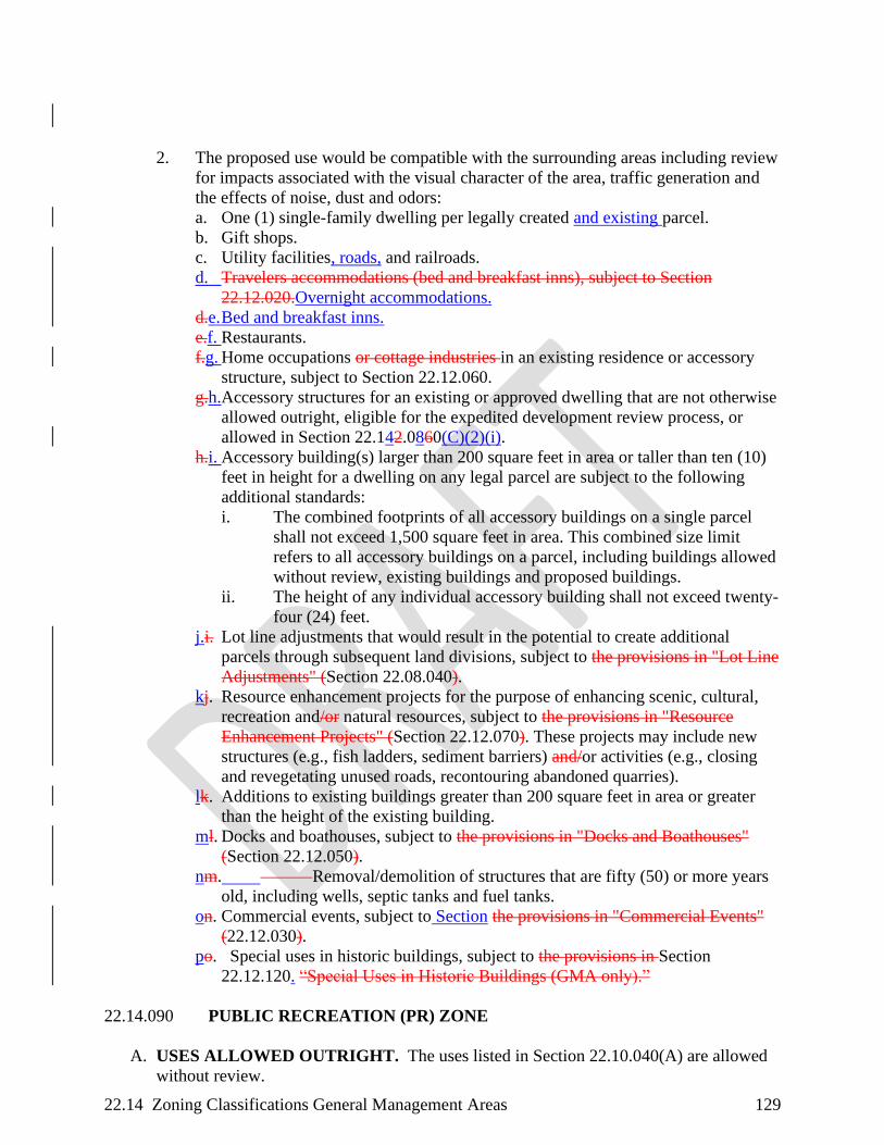
22.14 Zoning Classifications General Management Areas 129
2. The proposed use would be compatible with the surrounding areas including review
for impacts associated with the visual character of the area, traffic generation and
the effects of noise, dust and odors:
a. One (1) single-family dwelling per legally created and existing parcel.
b. Gift shops.
c. Utility facilities, roads, and railroads.
d. Travelers accommodations (bed and breakfast inns), subject to Section
22.12.020.Overnight accommodations.
d.e. Bed and breakfast inns.
e.f. Restaurants.
f.g. Home occupations or cottage industries in an existing residence or accessory
structure, subject to Section 22.12.060.
g.h.Accessory structures for an existing or approved dwelling that are not otherwise
allowed outright, eligible for the expedited development review process, or
allowed in Section 22.142.0860(C)(2)(i).
h.i. Accessory building(s) larger than 200 square feet in area or taller than ten (10)
feet in height for a dwelling on any legal parcel are subject to the following
additional standards:
i. The combined footprints of all accessory buildings on a single parcel
shall not exceed 1,500 square feet in area. This combined size limit
refers to all accessory buildings on a parcel, including buildings allowed
without review, existing buildings and proposed buildings.
ii. The height of any individual accessory building shall not exceed twenty-
four (24) feet.
j.i. Lot line adjustments that would result in the potential to create additional
parcels through subsequent land divisions, subject to the provisions in "Lot Line
Adjustments" (Section 22.08.040).
kj. Resource enhancement projects for the purpose of enhancing scenic, cultural,
recreation and/or natural resources, subject to the provisions in "Resource
Enhancement Projects" (Section 22.12.070). These projects may include new
structures (e.g., fish ladders, sediment barriers) and/or activities (e.g., closing
and revegetating unused roads, recontouring abandoned quarries).
lk. Additions to existing buildings greater than 200 square feet in area or greater
than the height of the existing building.
ml. Docks and boathouses, subject to the provisions in "Docks and Boathouses"
(Section 22.12.050).
nm. Removal/demolition of structures that are fifty (50) or more years
old, including wells, septic tanks and fuel tanks.
on. Commercial events, subject to Section the provisions in "Commercial Events"
(22.12.030).
po. Special uses in historic buildings, subject to the provisions in Section
22.12.120. “Special Uses in Historic Buildings (GMA only).”
22.14.090 PUBLIC RECREATION (PR) ZONE
A. USES ALLOWED OUTRIGHT. The uses listed in Section 22.10.040(A) are allowed
without review.
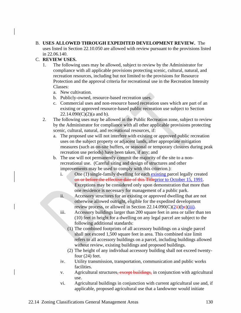
22.14 Zoning Classifications General Management Areas 130
B. USES ALLOWED THROUGH EXPEDITED DEVELOPMENT REVIEW. The
uses listed in Section 22.10.050 are allowed with review pursuant to the provisions listed
in 22.06.140.
C. REVIEW USES.
1. The following uses may be allowed, subject to review by the Administrator for
compliance with all applicable provisions protecting scenic, cultural, natural, and
recreation resources, including but not limited to the provisions for Resource
Protection and the approval criteria for recreational use in the Recreation Intensity
Classes:
a. New cultivation.
b. Publicly-owned, resource-based recreation uses.
c. Commercial uses and non-resource based recreation uses which are part of an
existing or approved resource-based public recreation use subject to Section
22.14.090(C)(2)(a and b).
2. The following uses may be allowed in the Public Recreation zone, subject to review
by the Administrator for compliance with all other applicable provisions protecting
scenic, cultural, natural, and recreational resources, if:
a. The proposed use will not interfere with existing or approved public recreation
uses on the subject property or adjacent lands, after appropriate mitigation
measures (such as on-site buffers, or seasonal or temporary closures during peak
recreation use periods) have been taken, if any; and
b. The use will not permanently commit the majority of the site to a non-
recreational use. (Careful siting and design of structures and other
improvements may be used to comply with this criterion.):
i. One (1) single-family dwelling for each existing parcel legally created
on or before the effective date of this Titleprior to October 15, 1991.
Exceptions may be considered only upon demonstration that more than
one residence is necessary for management of a public park.
ii. Accessory structures for an existing or approved dwelling that are not
otherwise allowed outright, eligible for the expedited development
review process, or allowed in Section 22.14.090(C)(21)(bc)(iii).
iii. Accessory buildings larger than 200 square feet in area or taller than ten
(10) feet in height for a dwelling on any legal parcel are subject to the
following additional standards:
(1) The combined footprints of all accessory buildings on a single parcel
shall not exceed 1,500 square feet in area. This combined size limit
refers to all accessory buildings on a parcel, including buildings allowed
without review, existing buildings and proposed buildings.
(2) The height of any individual accessory building shall not exceed twenty-
four (24) feet.
iv. Utility transmission, transportation, communication and public works
facilities.
v. Agricultural structures, except buildings, in conjunction with agricultural
use.
vi. Agricultural buildings in conjunction with current agricultural use and, if
applicable, proposed agricultural use that a landowner would initiate
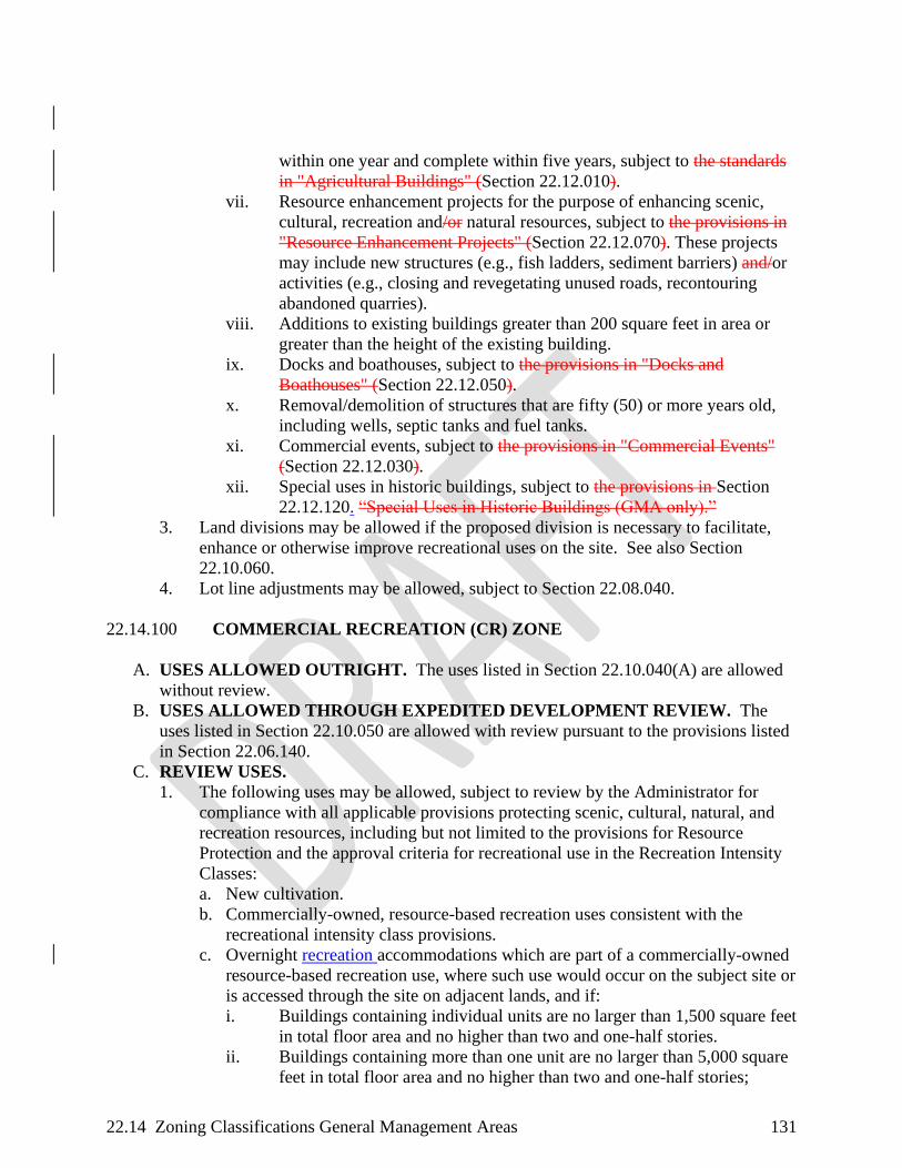
22.14 Zoning Classifications General Management Areas 131
within one year and complete within five years, subject to the standards
in "Agricultural Buildings" (Section 22.12.010).
vii. Resource enhancement projects for the purpose of enhancing scenic,
cultural, recreation and/or natural resources, subject to the provisions in
"Resource Enhancement Projects" (Section 22.12.070). These projects
may include new structures (e.g., fish ladders, sediment barriers) and/or
activities (e.g., closing and revegetating unused roads, recontouring
abandoned quarries).
viii. Additions to existing buildings greater than 200 square feet in area or
greater than the height of the existing building.
ix. Docks and boathouses, subject to the provisions in "Docks and
Boathouses" (Section 22.12.050).
x. Removal/demolition of structures that are fifty (50) or more years old,
including wells, septic tanks and fuel tanks.
xi. Commercial events, subject to the provisions in "Commercial Events"
(Section 22.12.030).
xii. Special uses in historic buildings, subject to the provisions in Section
22.12.120. “Special Uses in Historic Buildings (GMA only).”
3. Land divisions may be allowed if the proposed division is necessary to facilitate,
enhance or otherwise improve recreational uses on the site. See also Section
22.10.060.
4. Lot line adjustments may be allowed, subject to Section 22.08.040.
22.14.100 COMMERCIAL RECREATION (CR) ZONE
A. USES ALLOWED OUTRIGHT. The uses listed in Section 22.10.040(A) are allowed
without review.
B. USES ALLOWED THROUGH EXPEDITED DEVELOPMENT REVIEW. The
uses listed in Section 22.10.050 are allowed with review pursuant to the provisions listed
in Section 22.06.140.
C. REVIEW USES.
1. The following uses may be allowed, subject to review by the Administrator for
compliance with all applicable provisions protecting scenic, cultural, natural, and
recreation resources, including but not limited to the provisions for Resource
Protection and the approval criteria for recreational use in the Recreation Intensity
Classes:
a. New cultivation.
b. Commercially-owned, resource-based recreation uses consistent with the
recreational intensity class provisions.
c. Overnight recreation accommodations which are part of a commercially-owned
resource-based recreation use, where such use would occur on the subject site or
is accessed through the site on adjacent lands, and if:
i. Buildings containing individual units are no larger than 1,500 square feet
in total floor area and no higher than two and one-half stories.
ii. Buildings containing more than one unit are no larger than 5,000 square
feet in total floor area and no higher than two and one-half stories;

22.14 Zoning Classifications General Management Areas 132
iii. The total number of individual units shall not exceed twenty-five (25),
unless the proposed development complies with standards of Section
22.14.100(C)(1)(d).
iv. Clustered overnight travelers recreation accommodations up to thirty-
five (35) units if:
(1) The average total floor area of all units is 1,000 square feet or less per
unit;
(2) A minimum of fifty percent (50 %) of the project site is dedicated to
undeveloped, open areas, not including roads or parking areas; and
(3) The facility is in an area classified for high intensity recreation
(Recreation Intensity Class 4).
d. Commercial uses, including restaurants sized to accommodate overnight visitors
and their guests, and non-resource-based recreation uses which are part of an
existing or approved resource-based commercial recreation use subject to
Section 22.14.100(C)(2)(a and b).
e. Special uses in historic buildings, subject to the provisions in Section
22.12.120. “Special Uses in Historic Buildings (GMA only).”
f. Recreation resorts may be allowed on sites that include an existing industrial
complex, subject to compliance with the provisions in Section 22.12.150.
2. The following uses may be allowed in the Commercial Recreation zone, subject to
review by the Administrator for compliance with all other applicable provisions
protecting scenic, cultural, natural, and recreational resources, if:
a. The proposed use will not interfere with existing or approved commercial
recreation uses on the subject property or adjacent lands, after appropriate
mitigation measures (such as on-site buffers, or seasonal or temporary closures
during peak recreation use periods) have been taken, if any; and
b. The use will not permanently commit the majority of the site to a non-
recreational use. (Careful siting and design of structures and other
improvements may be used to comply with this criterion.):
i. One (1) single-family dwelling on each existing parcel legally created
prior to October 15, 1991.
ii. Accessory structures for an existing or approved dwelling that are not
otherwise allowed outright, eligible for the expedited development
review process, or allowed in Section 22.14.100(C)(2)(b)(iii).
iii. Accessory buildings larger than 200 square feet in area or taller than ten
(10) feet in height for a dwelling on any legal parcel are subject to the
following additional standards:
(1) The combined footprints of all accessory buildings on a single parcel
shall not exceed 1,500 square feet in area. This combined size limit
refers to all accessory buildings on a parcel, including buildings allowed
without review, existing buildings and proposed buildings.
(2) The height of any individual accessory building shall not exceed twenty-
four (24) feet.
iv. Utility transmission, transportation and communication facilities.
v. Land divisions may be allowed if the proposed land division is necessary
to facilitate, enhance or otherwise improve recreational uses on the site.
See also Section 22.10.060.

22.14 Zoning Classifications General Management Areas 133
vi. Agricultural structures, except buildings, in conjunction with agricultural
use.
vii. Agricultural buildings in conjunction with current agricultural use and, if
applicable, proposed agricultural use that a landowner would initiate
within one (1) year and complete within five years, subject to the
standards in "Agricultural Buildings" (Section 22.12.010).
viii. Resource enhancement projects for the purpose of enhancing scenic,
cultural, recreation and/or natural resources, subject to the provisions in
"Resource Enhancement Projects" (Section 22.12.070). These projects
may include new structures (e.g., fish ladders, sediment barriers) and/or
activities (e.g., closing and revegetating unused roads, recontouring
abandoned quarries).
ix. Additions to existing buildings greater than 200 square feet in area or
greater than the height of the existing building.
x. Docks and boathouses, subject to the provisions in "Docks and
Boathouses" (Section 22.12.050).
xi. Removal/demolition of structures that are fifty (50) or more years old,
including wells, septic tanks and fuel tanks.
xii. Commercial events, subject to the provisions in "Commercial Events"
(Section 22.12.030).
xiii. Lot line adjustments may be allowed, subject to Section 22.08.040.
22.14.110 OPEN SPACE (OS) ZONE
A. USES ALLOWED OUTRIGHT. The uses listed in Section 22.10.040(B) are allowed
without review.
B. USES ALLOWED THROUGH EXPEDITED DEVELOPMENT REVIEW. The
uses listed in Section 22.10.050 are allowed with review pursuant to the provisions listed
in Section 22.06.140
C. REVIEW USES.
1. The following uses may be allowed, subject to review by the Administrator for
compliance with all applicable provisions protecting scenic, cultural, natural, and
recreation resources in all Open Space (OS) Zones:
a. Low-intensity recreation, subject to provisions governing recreational intensity
classes set out in Section 22.24.020(B)(2). of this Title.
b. Land divisions to facilitate efforts to protect and enhance scenic, cultural,
natural or recreation resources.
c. Repair, maintenance, operation and iImprovement, not including expansion, of
existing structures, trails, roads, railroads, utility facilities and hydroelectric
facilities.
d. Removal of timber, rocks or other materials for purposes of public safety and
placement of structures for public safety.
e. Resource enhancement projects for the purpose of enhancing scenic, cultural,
recreation, and/or natural resources, subject to the provisions in "Resource
Enhancement Projects" (Section 22.12.070). These projects may include new
structures (e.g., fish ladders, sediment barriers) and/or activities (e.g., closing
and revegetating unused roads, recontouring abandoned quarries).
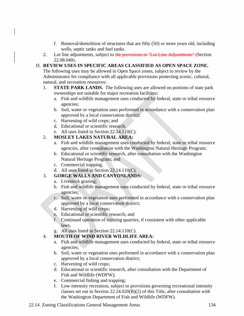
22.14 Zoning Classifications General Management Areas 134
f. Removal/demolition of structures that are fifty (50) or more years old, including
wells, septic tanks and fuel tanks.
2. Lot line adjustments, subject to the provisions in "Lot Line Adjustments" (Section
22.08.040).
D. REVIEW USES IN SPECIFIC AREAS CLASSIFIED AS OPEN SPACE ZONE.
The following uses may be allowed in Open Space zones, subject to review by the
Administrator for compliance with all applicable provisions protecting scenic, cultural,
natural, and recreation resources:
1. STATE PARK LANDS. The following uses are allowed on portions of state park
ownerships not suitable for major recreation facilities:
a. Fish and wildlife management uses conducted by federal, state or tribal resource
agencies;
b. Soil, water or vegetation uses performed in accordance with a conservation plan
approved by a local conservation district;
c. Harvesting of wild crops; and
d. Educational or scientific research.
e. All uses listed in Section 22.14.110(C).
2. MOSLEY LAKES NATURAL AREA:
a. Fish and wildlife management uses conducted by federal, state or tribal resource
agencies, after consultation with the Washington Natural Heritage Program;
b. Educational or scientific research, after consultation with the Washington
Natural Heritage Program; and
c. Commercial trapping.
d. All uses listed in Section 22.14.110(C).
3. GORGE WALLS AND CANYONLANDS:
a. Livestock grazing;
b. Fish and wildlife management uses conducted by federal, state or tribal resource
agencies;
c. Soil, water or vegetation uses performed in accordance with a conservation plan
approved by a local conservation district;
d. Harvesting of wild crops;
e. Educational or scientific research; and
f. Continued operation of existing quarries, if consistent with other applicable
laws.
g. All uses listed in Section 22.14.110(C).
4. MOUTH OF WIND RIVER WILDLIFE AREA:
a. Fish and wildlife management uses conducted by federal, state or tribal resource
agencies;
b. Soil, water or vegetation uses performed in accordance with a conservation plan
approved by a local conservation district;
c. Harvesting of wild crops;
d. Educational or scientific research, after consultation with the Department of
Fish and Wildlife (WDFW);
e. Commercial fishing and trapping;
f. Low-intensity recreation, subject to provisions governing recreational intensity
classes set out in Section 22.24.020(B)(2) of this Title, after consultation with
the Washington Department of Fish and Wildlife (WDFW).

22.14 Zoning Classifications General Management Areas 135
g. All uses listed in Section 22.14.110(C).
22.16 Zoning Classifications Special Management Areas 136
CHAPTER 22.16 ZONING CLASSIFICATIONS SPECIAL MANAGEMENT
AREA
22.16.010 AGRICULTURAL (A) ZONE ................................................................136
22.16.020 FOREST (F) ZONE .................................................................................139
22.16.030 PUBLIC RECREATION (P) ZONE .......................................................148
22.16.040 OPEN SPACE (S-O) ZONE ....................................................................150
22.16.010 AGRICULTURAL (A) ZONE
A. USES ALLOWED OUTRIGHT. The uses listed in Section 22.10.040(A) are allowed
without review.
B. USES ALLOWED THROUGH EXPEDITED DEVELOPMENT REVIEW. The
uses listed in Section 22.10.050 are allowed with review pursuant to the provisions listed
in Section 22.06.140.
C. REVIEW USES. The following uses may be allowed, subject to review by the
Administrator for compliance with all applicable provisions of this Title, and if the use or
development will be sited to minimize the loss of land suitable for the production of
agricultural crops or livestock:
1. Agricultural structures, except buildings, in conjunction with agricultural use.
2. Agricultural buildings in conjunction with current agricultural use and, if
applicable, proposed agricultural use that a landowner would initiate within one
year and complete within five years, subject to the standards in "Agricultural
Buildings" (Section 22.12.010).
3. Accessory structures for an existing or approved dwelling that are not otherwise
allowed outright, eligible for the expedited development review process, or allowed
in Section 22.16.010(C)(4) or Section 22.16.010(C)(5).
4. Accessory building(s) larger than 200 square feet in area or taller than ten (10) feet
in height for a dwelling on any legal parcel less than or equal to ten (10) acres in
size are subject to the following additional standards:
a. The combined footprints of all accessory buildings on a single parcel shall not
exceed 1,500 square feet in area. This combined size limit refers to all accessory
buildings on a parcel, including buildings allowed without review, existing
buildings and proposed buildings.
b. The height of any individual accessory building shall not exceed twenty-four
(24) feet.
5. Accessory building(s) larger than 200 square feet in area or taller than ten (10) feet
in height for a dwelling on any legal parcel larger than ten (10) acres in size are
subject to the following additional standards:
a. The combined footprints of all accessory buildings on a single parcel shall not
exceed 2,500 square feet in area. This combined size limit refers to all accessory
buildings on a parcel, including buildings allowed without review, existing
buildings and proposed buildings.
b. The footprint of any individual accessory building shall not exceed 1,500 square
feet.
c. The height of any individual accessory building shall not exceed twenty-four
(24) feet.

22.16 Zoning Classifications Special Management Areas 137
6. Fruit and produce stands upon a showing that sales will be limited to agricultural
products raised on the property and other agriculture properties in the local region.
7. Aquaculture.
8. Temporary asphalt/batch plant operations related to public road projects, not to
exceed six (6) months.
9. Resource enhancement projects for the purpose of enhancing scenic, cultural,
recreation and/or natural resources, subject to the provisions in "Resource
Enhancement Projects" (Section 22.12.070). These projects may include new
structures (e.g., fish ladders, sediment barriers) and/or activities (e.g., closing and
revegetating unused roads, recontouring abandoned quarries).
10. Forest uses and practices, as allowed in Section 22.16.020.
11. A single-family dwelling necessary for and accessory to agricultural use, upon a
demonstration that:
a. The proposed dwelling would be the only dwelling on the subject farm or ranch,
including contiguous lots/parcels;
b. The minimum parcel size is at least forty (40) contiguous acres;
c. The farm or ranch upon which the dwelling will be located is currently devoted
to agricultural use, where the day-to-day activities of one or more residents of
the agricultural dwelling will be principally directed to the agricultural use of
the land; and
d. The farm or ranch is a commercial agricultural enterprise as determined by an
evaluation of the following factors:
i. Size of the entire farm or ranch, including all land in the same
ownership;
ii. Type(s) of agricultural uses (crops, livestock) and acreage;
iii. Operational requirements for the particular agricultural use common to
area agricultural operations; and
iv. The farm or ranch, and all its contiguous parcels, is capable of
producingmust produce at least $4080,000 in gross annual income in
2020 dollars. This gross annual income amount shall be indexed for
inflation on an annual basis using Consumer Price Index data from the
US Bureau of Labor Statistics, and the new adjusted amount for each
calendar year (calculated from 2020 dollars) will be posted on the Gorge
Commission’s website by January 15 of each year. This determination
can be made using the formula (X)(Y)(Z) = I where:
(1) X = Average yield of the commodity per acre, or unit of production;
(2) Y = Average price of the commodity;
(3) Z = Total acres suitable for production, or total units of production that
can be sustained, on the subject farm or ranch; and
(4) I = Income capabilityAverage income.
12. Farm labor housing on a parcel with an existing dwelling upon a showing that:
a. The proposed housing is necessary and accessory to a current agricultural use
and the operation is a commercial agricultural enterprise as described in Section
22.16.010(C)(11)(d), above.
b. The housing shall be seasonal unless it is shown that an additional full-time
dwelling is necessary for the current agricultural use. Seasonal use shall not
exceed nine (9) months.

22.16 Zoning Classifications Special Management Areas 138
c. The housing shall be located to minimize the conversion of lands capable of
production of farm crops and livestock and shall not force a significant change
in or significantly increase the cost of accepted agricultural uses employed on
nearby lands devoted to agricultural use.
13. Home occupations and cottage industries (See Section 22.12.060), if compatible
with agricultural use. Buffer zones may be considered to protect agricultural
practices from conflicting uses.
14. Bed and breakfast inns subject to the standards set out in Section 22.02.020 hereof,
if the development is compatible with agricultural use. Buffer zones may be
considered to protect agricultural practices from conflicting uses.
15. Utility facilities necessary for public service upon a showing that:
a. There is no alternative location with less adverse effect on agricultural lands.
b. The size is the minimum necessary to provide the service.
16. Community facilities and non-profit facilities related to agricultural resource
management.
17. Expansion of existing non-profit group camps, retreats, and conference or education
centers for the successful operation on the dedicated site. Expansion beyond the
dedicated site is prohibited.
18. Public recreation, commercial recreation, interpretive and educational developments
and uses, subject to the provisions governing recreational intensity classes set out in
Section 22.32.020 of this Title.
19. Road and railroad construction and reconstruction.
20. Agricultural product processing and packaging, upon demonstration that the
processing will be limited to products produced primarily on or adjacent to the
property. "Primarily" means a clear majority of the product as measured by
volume, weight or value.
21. Exploration, development and production of sand, gravel and crushed rock for the
construction, maintenance or reconstruction of roads used to manage or harvest
commercial forest products on lands within the Special Management Areas.
22. New cultivation or new agricultural use outside of previously disturbed and
regularly worked fields or areas. Clearing trees for new agricultural use is subject
to the additional requirements of Section 22.16.020(C)(33).
23. On a parcel of forty (40) acres or greater with an existing dwelling, the temporary
use of a mobileplacement and occupancy of a recreational vehicle or manufactured
home in the case of a family hardship, subject to the provisions for hardship
dwellings in "Temporary Use - Hardship Dwelling" (Section 22.12.110).
24. Additions to existing buildings greater than 200 square feet in area or greater than
the height of the existing building.
25. Docks and boathouses, subject to the provisions in "Docks and Boathouses"
(Section 22.12.050).
26. Removal/demolition of structures that are fifty (50) or more years old, including
wells, septic tanks and fuel tanks.
27. Disposal sites managed and operated by the Washington State Department of
Transportation, or Skamania County Department of Public Works for earth
materials and any intermixed vegetation generated by routine or emergency/disaster
public road maintenance activities within the National Scenic Area, subject to

22.16 Zoning Classifications Special Management Areas 139
compliance with the provisions in "Disposal Sites for Spoil Materials from Public
Road Maintenance Activities" (Section 22.12.040).
22.16.020 FOREST (F) ZONE
A. USES ALLOWED OUTRIGHT. The uses listed in Section 22.10.040(A) are allowed
without review.
B. USES ALLOWED THROUGH EXPEDITED DEVELOPMENT REVIEW. The
uses listed in Section 22.10.050 are allowed with review pursuant to the provisions listed
in Section 22.06.140.
C. REVIEW USES. The following uses may be allowed, subject to review by the
Administrator for compliance with all applicable provisions of this Title, and if the use or
development will be sited to minimize the loss of land suitable for the production of
forest products:
1. Agricultural structures, except buildings, in conjunction with agricultural use.
2. Agricultural buildings in conjunction with current agricultural use and, if
applicable, proposed agricultural use that a landowner would initiate within one
year and complete within five years, subject to the standards in "Agricultural
Buildings" (Section 22.12.010).
3. Accessory structures for an existing or approved dwelling that are not otherwise
allowed outright, eligible for the expedited development review process, or allowed
in Section 22.16.020(C)(4) or Section 22.16.020(C)(5).
4. Accessory building(s) larger than 200 square feet in area or taller than ten (10) feet
in height for a dwelling on any legal parcel less than or equal to ten (10) acres in
size are subject to the following additional standards:
a. The combined footprints of all accessory buildings on a single parcel shall not
exceed 1,500 square feet in area. This combined size limit refers to all accessory
buildings on a parcel, including buildings allowed without review, existing
buildings and proposed buildings.
b. The height of any individual accessory building shall not exceed twenty-four
(24) feet.
5. Accessory building(s) larger than 200 square feet in area or taller than ten (10) feet
in height for a dwelling on any legal parcel larger than ten (10) acres in size are
subject to the following additional standards:
a. The combined footprints of all accessory buildings on a single parcel shall not
exceed 2,500 square feet in area. This combined size limit refers to all accessory
buildings on a parcel, including buildings allowed without review, existing
buildings and proposed buildings.
b. The footprint of any individual accessory building shall not exceed 1,500 square
feet.
c. The height of any individual accessory building shall not exceed twenty-four
(24) feet.
6. Fruit and produce stands upon a showing that sales will be limited to agricultural
products raised on the property and other agriculture properties in the local region.
7. Aquaculture.
8. Temporary asphalt/batch plant operations related to public road projects, not to
exceed six (6) months.
22.16 Zoning Classifications Special Management Areas 140
9. Resource enhancement projects for the purpose of enhancing scenic, cultural,
recreation and/or natural resources, subject to the provisions in "Resource
Enhancement Projects" (Section 22.12.070). These projects may include new
structures (e.g., fish ladders, sediment barriers) and/or activities (e.g., closing and
revegetating unused roads, recontouring abandoned quarries).
10. A single-family dwelling necessary for and accessory to agricultural use, upon a
demonstration that:
a. The proposed dwelling would be the only dwelling on the subject farm or ranch,
including contiguous lots/parcels;
b. The minimum parcel size is at least forty (40) contiguous acres;
c. The farm or ranch upon which the dwelling will be located is currently devoted
to agricultural use, where the day-to-day activities of one or more residents of
the agricultural dwelling will be principally directed to the agricultural use of
the land; and
d. The farm or ranch is a commercial agricultural enterprise as determined by an
evaluation of the following factors:
i. Size of the entire farm or ranch, including all land in the same
ownership;
ii. Type(s) of agricultural uses (crops, livestock) and acreage;
iii. Operational requirements for the particular agricultural use common to
area agricultural operations; and
iv. The farm or ranch, and all its contiguous parcels, is capable of
producingmust produce at least $4080,000 in gross annual income in
2020 dollars. This gross annual income amount shall be indexed for
inflation on an annual basis using Consumer Price Index data from the
US Bureau of Labor Statistics, and the new adjusted amount for each
calendar year (calculated from 2020 dollars) will be posted on the Gorge
Commission’s website by January 15 of each year. This determination
can be made using the formula (X)(Y)(Z) = I where:
(1) X = Average yield of the commodity per acre, or unit of production;
(2) Y = Average price of the commodity;
(3) Z = Total acres suitable for production, or total units of production that
can be sustained, on the subject farm or ranch; and
(4) I = Income capabilityAverage income.
11. Farm labor housing on a parcel with an existing dwelling upon a showing that:
a. The proposed housing is necessary and accessory to a current agricultural use
and the operation is a commercial agricultural enterprise as described in Section
22.16.020(C)(10)(d)(iv).
b. The housing shall be seasonal unless it is shown that an additional full-time
dwelling is necessary for the current agricultural use. Seasonal use shall not
exceed nine (9) months.
c. The housing shall be located to minimize the conversion of lands capable of
production of farm crops and livestock and shall not force a significant change
in or significantly increase the cost of accepted agricultural uses employed on
nearby lands devoted to agricultural use.
22.16 Zoning Classifications Special Management Areas 141
12. Home occupations and cottage industries (See Section 22.12.060), if compatible
with agricultural use. Buffer zones may be considered to protect agricultural
practices from conflicting uses.
13. Bed and breakfast inns subject to the standards set out in Section 22.12.020 hereof,
if the development if compatible with agricultural use. Buffer zones may be
considered to protect agricultural practices from conflicting uses.
14. Utility facilities necessary for public service upon a showing that:
a. There is no alternative location with less adverse effect on agricultural or forest
lands.
b. The size is the minimum necessary to provide the service.
15. Community facilities and non-profit facilities related to agricultural resource
management.
16. Expansion of existing non-profit group camps, retreats, and conference or education
centers for the successful operation on the dedicated site. Expansion beyond the
dedicated site is prohibited.
17. Public recreation, commercial recreation, interpretive and educational developments
and uses, subject to the provisions governing recreational intensity classes set out in
Section 22.32.020 of this Title.
18. Road and railroad construction and reconstruction.
19. Agricultural product processing and packaging, upon demonstration that the
processing will be limited to products produced primarily on or adjacent to the
property. "Primarily" means a clear majority of the product as measured by
volume, weight or value.
20. Exploration, development and production of sand, gravel and crushed rock for the
construction, maintenance or reconstruction of roads used to manage or harvest
commercial forest products on lands within the Special Management Areas.
21. New cultivation or new agricultural use outside of previously disturbed and
regularly worked fields or areas. Clearing trees for new agricultural use is subject
to the additional requirements of Section 22.16.020(C)(33).
22. On a parcel of forty (40) acres or greater with an existing dwelling, the temporary
use of a mobileplacement and occupancy of a recreational vehicle or manufactured
home in the case of a family hardship, subject to the provisions for hardship
dwellings in "Temporary Use - Hardship Dwelling" (Section 22.12.110).
23. Additions to existing buildings greater than 200 square feet in area or greater than
the height of the existing building.
24. Docks and boathouses, subject to the provisions in "Docks and Boathouses"
(Section 22.12.050).
25. Removal/demolition of structures that are fifty (50) or more years old, including
wells, septic tanks and fuel tanks.
26. Disposal sites managed and operated by the Washington State Department of
Transportation, or Skamania County Department of Public Works for earth
materials and any intermixed vegetation generated by routine or emergency/disaster
public road maintenance activities within the National Scenic Area, subject to
compliance with the provisions in "Disposal Sites for Spoil Materials from Public
Road Maintenance Activities" (Section 22.12.040).
27. Silvicultural nurseries.
28. Fish hatcheries.
22.16 Zoning Classifications Special Management Areas 142
29. Temporary portable facilities for the processing of forest products.
30. Towers and fire stations for forest fire protection.
31. Community facilities and nonprofit facilities related to forest resource management.
32. One single family dwelling on a parcel of forty (40) contiguous acres or larger if an
approved Forest Management Plan demonstrates that such dwelling shall be
necessary for and accessory to forest uses. The Forest Management Plan shall
demonstrate the following:
a. The dwelling will contribute substantially to the growing, propagation, and
harvesting of trees. The principal purpose for allowing a dwelling on forest
lands is to enable the resident to conduct efficient and effective management.
This requirement indicates a relationship between ongoing forest management
and the need for a dwelling on the subject property.
b. The subject parcel is enrolled in the state forest assessment program.
c. A plan for management of the parcel has beenis approved by the Washington
Department of Natural Resources. The plan must indicate:
i. The condition and productivity of lands to be managed;
ii. The operations the owner will carry out;
iii. A chronological description of when the operations will occur;
iv. Estimates of yield, labor and expenses; and
v. How the dwelling will contribute to the successful management of the
property.
d. No other dwellings exist on the parcel which are vacant or currently occupied
by persons not engaged in forest management of the subject parcel.
e. A declaration has beenis signed by the landowner and recorded into the county
deed records specifying that the owners, successors, heirs and assigns of the
property are aware that adjacent and nearby operations are entitled to carry on
accepted agricultural or forest practices.
f. The dwelling complies with county dwelling, siting and state/county fire
protection requirements.
33. Clearing trees for new agricultural use with the following steps and subject to the
following additional provisions:
a. A Stewardship Plan shall be submitted and deemed complete by the
Administrator and submitted to the Forest Service for review. (See Section
22.16.020(D)(4)).
b. Clearing trees for new agricultural use shall be limited to fifteen (15) acres.
c. If the Stewardship Plan proves that the above provision is detrimental to the
proposed agricultural use, the final size of the clearing shall be determined by
the application of Section 22.16.020(C)(33)(d) and subject to Section
22.16.020(C)(33)(i).
d. After a thirty (30) day public comment period, the Forest Service shall review
the Stewardship Plan using the following criteria:
i. Scenic Resource provisions in Review Uses Section 22.16.020(D)(5)(a
and g) in this chapter.
ii. SMA Natural, Cultural and Recreational Resource Protection Chapters
22.28, 22.30 and 22.32.
iii. The Natural Resource Conservation Service (NRCS) soil unit
description shall indicate that soils are suitable for the proposed

22.16 Zoning Classifications Special Management Areas 143
agricultural use. The woodland management tables shall be used as part
of the analysis of suitability for both agricultural and forest uses.
iv. The size, shape and pattern on the landscape of the clearing for the new
agricultural use shall blend with the surrounding landscape pattern either
because the existing pattern includes agricultural openings or because
the new agricultural opening is designed to appear natural.
e. The Forest Service shall send the review statement to the Administrator. The
Forest Service shall state whether or not the new agricultural use should proceed
including any conditions that are recommended to be required by the
Administrator.
f. The Administrator will accept an application for new agricultural use on
forested lands after receipt of a positive review statement from the Forest
Service.
g. The forest practice portion of the new agricultural use shall not be approved by
the state forestry department or Administrator until a decision on the new
agricultural use is issued from the Administrator.
h. The new agricultural use shall be operational within two (2) years of the time
frame described in the approved Stewardship Plan.
i. New agricultural uses with an approved Stewardship Plan requiring more than
fifteen (15) acres shall attain the final approved size sequentially. After the first
fifteen (15) cleared acres is operational, each subsequent clearing shall not
occur until the previous clearing is operational.
34. Forest uses and practices, subject to Section 22.16.020(D).
D. FOREST PRACTICES.
1. The Forest Service shall, in collaboration with the Department of Natural Resources
review site plans for forest practices for compliance with the SMA forest practice
provisions. Forest Service review decisions on forest practices are subject to review
by the Regional Forester.
2. The site plan shall include the following in addition to general site plan
requirements under Section 22.06.060 and Section 22.06.080 of this Title:
a. Delineate the following on a recent aerial photo or detailed map:
i. The size, shape, and exact location of the proposed treatment area
including any clumps of leave trees to remain. If more than one
silvicultural prescription is to be used, code each on the photo.
ii. Other important natural features of the subject parcel such as steep areas,
streams, wetlands, rock outcrops, etc.
iii. Road and structure construction and/or reconstruction location.
iv. Location of proposed rock or aggregate sources.
v. Major skid trails, landings and yarding corridors.
vi. Commercial firewood cutting areas.
vii. Protection measures for scenic, cultural, natural and recreation
resources, such as road closures.
b. Describe the existing forest in terms of species, ages, sizes, landscape pattern
(including how it fits into the surrounding landscape pattern) and canopy
closure for all canopy layers.
22.16 Zoning Classifications Special Management Areas 144
c. Describe how the forest practice will fit into the existing landscape pattern and
how it will meet scenic and natural resource standards in Review Uses Section
22.16.020(D)(5) and Section 22.16.020(D)(6).
d. Written silvicultural prescriptions with projected post-treatment forest condition
specified in terms of species, ages, sizes, landscape pattern (including how it fits
into the surrounding landscape pattern) and canopy closure for all canopy
layers.
e. Road and structure construction and/or reconstruction design.
f. Existing and proposed rock pit development plans.
g. A discussion of slash disposal methods.
h. A reforestation plan as reviewed by the Washington Department of Natural
Resources.
3. As part of the application, flag, stake or mark buffers, any trees or downed wood to
be retained or removed (whichever makes the most sense), and areas for placing fill
or removing material in preparation for a field visit by the reviewer.
4. STEWARDSHIP PLAN REQUIREMENTS. The following information, in
addition to the applicable portions of the forest practice application requirements
above and general site plan requirements (Section 22.06.060 and Section 22.06.080)
shall be provided:
a. Outline the long termlong-term goals, proposed operations, and future
sustainability of the subject parcel.
b. Describe the time frame and steps planned to reach the long termlong-term
goals.
c. For Forest Practices, describe how the proposed activities fit into the long
termlong-term goals and sustainability of the parcel and/or forest health. The
following shall be addressed:
i. Describe the range of natural conditions expected in the forest in terms
of tree species, structure, and landscape pattern.
ii. Describe what the resulting tree species, structure, and landscape pattern
will be after the proposed activities.
iii. Give a clear explanation of how a deviation from the applicable
provisions may better achieve forest health objectives.
iv. Give a clear explanation of how and why the proposed activities will
lead move the forest towards its range of natural variability and result in
reaching sustainability, resiliency to disturbances.
d. For clearing trees for new agricultural use, the following shall be addressed in
addition to Section 22.16.020(D)(4)(a) and Section 22.16.020(D)(4)(b):
i. Submit NRCS soil unit description and map for each soil unit affected
by the proposed clearing or treatment.
ii. Based on the needs of the operation, give a clear explanation as to the
exact size of the clearing needed and how it will meet the natural and
scenic requirements set forth in Section 22.16.020(D)(5)(a) through
Section 22.16.020(D)(5)(d).
iii. Describe in sufficient detail for evaluation the proposed agricultural use,
the improvements needed on the parcel, time linetimeline for its
establishment, and its marketability.

22.16 Zoning Classifications Special Management Areas 145
iv. Show evidence that an agricultural specialist, such as the county
extension agent, has examined and found the proposed agricultural use
reasonable and viable.
5. For forest practices, the following scenic resource provisions shall apply:
a. Forest practices shall meet the design provisions and scenic standards for the
applicable landscape setting and zone (See Table 4 in Section 22.26.020).
b. In the western portion (to White Salmon River) of the SMA Coniferous
Woodland Landscape Setting, no more than eight percent (8 %) of the
composite KVA viewshed from which the forest practice is topographically
visible shall be in created forest openings at one (1) time. The viewshed
boundaries shall be delineated by the Forest Service. The Forest Service will
assist (as available) in calculating and delineating the percentage of the
composite KVA viewshed that is in created forest openings at one time.
c. In the western portion (to the White Salmon River) of the SMA Gorge Walls,
Canyonlands and Wildlands Landscape Setting, no more than four percent (4
%) of the composite KVA viewshed from which the forest practice is
topographically visible shall be in created forest openings at one time. The
viewshed boundaries shall be delineated by the Forest Service. The Forest
Service will assist (as available) in calculating and delineating the percentage of
the composite KVA viewshed that is in created forest openings at one time.
d. For all other landscape settings, created forest openings visible at one time shall
be within the desired range for the vegetation type as set forth in Natural
Resources provisions in Review Uses Section 22.16.020(D)(6)(a through c).
e. Size, shape, and dispersal of created forest openings shall maintain the desired
natural patterns in the landscape as set forth in Natural Resources provisions in
Review Uses, Section 22.16.020(D)(6)(a through c).
f. The maximum size of any created forest opening is set forth by the “Desired”
vegetation type in the Table 3 in Section 22.16.020(D).
i. If the treatment is proposed to go beyond the above provision based on
forest health or ecosystem function requirements, a Stewardship Plan
shall be required.
ii. If the Stewardship Plan proves that the above provision is detrimental to
either forest health or ecosystem function, the size of the created forest
opening shall be within the natural range for the vegetation type as listed
in the Table 3 for each vegetation type, shall not mimic catastrophic
fires, and shall maintain scenic standards.
g. Created forest openings shall not create a break or opening in the vegetation in
the skyline as viewed from a key viewing areaKVAs.
6. Forest practices shall maintain the following in addition to applicable natural
resources provisions in Chapter 22.28:
a. Silvicultural prescriptions shall maintain the desired natural forest stand
structures (tree species, spacing, layering, and mixture of sizes) based on forest
health and ecosystem function requirements. Forest tree stand structure shall
meet the requirements listed in the Table 3 for each vegetation type. Forest tree
stand structure is defined as the general structure of the forest in each vegetation
type within which is found forest openings.

22.16 Zoning Classifications Special Management Areas 146
b. Created forest openings shall be designed as mosaics not to exceed the limits
defined as Table 3 unless proposed as a deviation as allowed under the scenic
resource provision in Review Uses, Section 22.16.020(D)(5)(f).
c. Snag and down wood requirements shall be maintained or created as listed in
the Table 3 for each vegetation type.
d. If the treatment is proposed to deviate from the snag and down wood
requirements based on forest health or ecosystem function requirements, a
Stewardship Plan shall be required and shall show and provedemonstrate why a
deviation from the snag and down wood requirements is required.

22.16 Zoning Classifications Special Management Area 147
Table 3. Desired Forest Structure and Pattern 1 2 3 4 5 6 7
Vegetation
Type #
Forest Structure
(Average % total
canopy closure
(CC))*
Typical Forest Openings Size
Disturbance Caused
Historic Desired
(Natural)
Percent Openings at One Time
Historic Desired
(Natural)
Leave Trees
Includes all
available
remnant old
forest
Average
Down
Wood
Pieces 30’
long/acre
(scattered)
Average Snags
(Conifers)
No./acre
Snags are 20-40’ in
height
West
Conifer
▪ 60-80% CC
▪ Understory
layer variable
(0-60% of total
CC)
▪ Variable sizes
with mosaic
pattern,
irregular
shapes
▪ Mosaic fire 1-
100 acres
▪ Catastrophic
fire over 100
acres
▪ Retain forested
character
▪ Allow openings up
to 15 acres (up to 5
acres in foreground
of KVAs)
▪ All openings 1 acre
or less on National
Forest Land and all
Open Space LUD
▪ Openings retain 15-
40% CC
▪ 10% (mosaic
fire) up to 55%
(catastrophic
fire)
▪ Intense fire
return interval is
300 years
▪ Not to exceed 8%
for West
Coniferous
Woodland
Landscape Setting
and not to exceed
4% for Gorge
Walls,
Canyonlands and
Wildlands
Landscape Setting
▪ Widely dispersed,
variable sized
mosaic of irregular
shapes blending
with existing
openings
▪ Leave 15%
of existing
trees per
acre
throughout
opening
and in
clumps
▪ Include 3
trees per
acre of the
largest size
trees
available
▪ 18-25
pieces
greater
than
20”dbh
▪ 10 snags at 10-20”
dbh and 7 snags
greater than 20” dbh
East Conifer
(Ponderosa
Pine/Douglas
fir)
▪ 40-80% CC
▪ Understory
layer variable
(less than 25%
of total CC)
▪ Few openings
due to low
intensity fires
▪ ¼ to 2 acres
▪ Openings less than
1 acre
▪ Openings have 0-
40% CC
▪ Openings widely
dispersed
▪ 1-10% ▪ 1-10% (% by
vegetation type
▪ No leave
trees
required
▪ 3-6
pieces
greater
than 20”
dbh
▪ 5 snags at 10-20”
dbh and 3 snags
greater than 20” dbh
Ponderosa
Pine/ Oregon
Oak
▪ 25-60% CC
▪ Understory
layer greater
than 25% of
total CC
▪ Most natural
openings due
to poor soil
▪ Disturbance
openings few
▪ Openings less than
1 acre
▪ Openings have 0-
25% CC
▪ Openings widely
dispersed
▪ 1-10% ▪ 1-10% (% by
vegetation type)
▪ No leave
trees
required
▪ 1-3
pieces
greater
than 20”
dbh
▪ 5 snags at 10-20”
dbh and 3 snags
greater than 20” dbh
▪ Oak snags can be
counted if already
dead or partially
dead
# Map available at the Forest Service National Scenic Area Office * Does not apply to openings dbh: Diameter at Breast Height
22.16 Zoning Classifications Special Management Area 148
22.16.030 PUBLIC RECREATION (P) ZONE
A. USES ALLOWED OUTRIGHT. The uses listed in Section 2210.040(A) are allowed
without review.
B. USES ALLOWED THROUGH EXPEDITED DEVELOPMENT REVIEW. The
uses listed in Section 22.10.050 are allowed with review pursuant to the provisions listed
in 22.06.140.
C. REVIEW USES. The following uses may be allowed, subject to review by the
Administrator for compliance with all applicable provisions of this Title:
1. Forest uses and practices, consistent with the provisions of Section 22.16.020,
except uses listed in Section 22.16.020(C)(4, 5, 17 and 26).
2. One (1) single-family dwelling on a parcel of forty (40) contiguous acres or larger
when it either meets the conditions established for dwellings on agriculture and
forest lands or when shown to be necessary for public recreation site management
purposes.
3. New cultivation or new agricultural use outside of previously disturbed and
regularly worked fields or areas. Clearing of trees for new agricultural use is
subject to Section 22.16.020(C)(33).
4. Resource enhancement projects for the purpose of enhancing scenic, cultural,
recreation and/or natural resources, subject to the provisions in "Resource
Enhancement Projects" (Section 22.12.070). These projects may include new
structures (e.g., fish ladders, sediment barriers) and/or activities (e.g., closing and
revegetating unused roads, recontouring abandoned quarries).
5. Public trails, consistent with Chapter 22.32.020.
6. Public recreational facilities, consistent with Chapter 22.32.020.
7. Public non-profit group camps, retreats, conference or educational centers and
interpretive facilities.
8. Home occupations and cottage industries. See also Section 22.12.060.
9. Road and railroad construction and reconstruction.
10. Utility facilities for public service if:
a. There is no alternative location with less adverse effect on Public Recreation
land; and
b. The size is the minimum necessary to provide the service.
11. Accessory structures for an existing or approved dwelling that are not otherwise
allowed outright, eligible for the expedited development review process, or allowed
in Section 22.16.030(C)(12).
12. Accessory buildings larger than 200 square feet in area or taller than ten (10) feet in
height for a dwelling on any legal parcel are subject to the following additional
standards:
a. The combined footprints of all accessory buildings on a single parcel shall not
exceed 1,500 square feet in area. This combined size limit refers to all accessory
buildings on a parcel, including buildings allowed without review, existing
buildings and proposed buildings.
b. The height of any individual accessory building shall not exceed twenty-four
(24) feet.
13. On a parcel of forty (40) acres or greater with an existing dwelling, the temporary
use of a mobile homeplacement and occupancy of a recreational vehicle or
22.16 Zoning Classifications Special Management Area 149
manufactured home in the case of a family hardship, subject to the provisions for
hardship dwellings in "Temporary Use - Hardship Dwelling" (Section 22.12.110).
14. Additions to existing buildings greater than 200 square feet in area or greater than
the height of the existing building.
15. Docks and boathouses, subject to the provisions in "Docks and Boathouses"
(Section 22.12.050).
16. Removal/demolition of structures that are fifty (50) or more years old, including
wells, septic tanks and fuel tanks.
17. Agricultural structures, except buildings, in conjunction with agricultural use.
18. Agricultural buildings in conjunction with current agricultural use and, if
applicable, proposed agricultural use that a landowner would initiate within one
year and complete within five (5) years, subject to the standards in "Agricultural
Buildings" (Section 22.12.010).
19. Fruit and produce stands upon a showing that sales will be limited to agricultural
products raised on the property and other agriculture properties in the local region.
20. Aquaculture.
21. Temporary asphalt/batch plant operations related to public road projects, not to
exceed six (6) months.
22. A single-family dwelling necessary for and accessory to agricultural use, upon a
demonstration that:
a. The proposed dwelling would be the only dwelling on the subject farm or ranch,
including contiguous lots/parcels;
b. The minimum parcel size is at least forty (40) contiguous acres;
c. The farm or ranch upon which the dwelling will be located is currently devoted
to agricultural use, where the day-to-day activities of one or more residents of
the agricultural dwelling will be principally directed to the agricultural use of
the land; and
d. The farm or ranch is a commercial agricultural enterprise as determined by an
evaluation of the following factors:
i. Size of the entire farm or ranch, including all land in the same
ownership;
ii. Type(s) of agricultural uses (crops, livestock) and acreage;
iii. Operational requirements for the particular agricultural use common to
area agricultural operations; and
iv. The farm or ranch, and all its contiguous constituent parcels, is capable
of producingmust produce at least $4080,000 in gross annual income in
2020 dollars. This gross annual income amount shall be indexed for
inflation on an annual basis using Consumer Price Index data from the
U.S. Bureau of Labor Statistics, and the new adjusted amount for each
calendar year (calculated from 2020 dollars) will be posted on the Gorge
Commission’s website by January 15 of each year. This determination
can be made using the formula (X)(Y)(Z) = I where:
(1) X = Average yield of the commodity per acre, or unit of production;
(2) Y = Average price of the commodity;
(3) Z = Total acres suitable for production, or total units of production that
can be sustained, on the subject farm or ranch; and
(4) I = Income capability.Annual income.
22.16 Zoning Classifications Special Management Area 150
23. Farm labor housing on a parcel with an existing dwelling upon a showing that:
a. The proposed housing is necessary and accessory to a current agricultural use
and the operation is a commercial agricultural enterprise as described in Section
22.16.030(C)(226)(d)(iv), above.
b. The housing shall be seasonal unless it is shown that an additional full-time
dwelling is necessary for the current agricultural use. Seasonal use shall not
exceed nine (9) months.
c. The housing shall be located to minimize the conversion of lands capable of
production of farm crops and livestock and shall not force a significant change
in or significantly increase the cost of accepted agricultural uses employed on
nearby lands devoted to agricultural use.
24. Community facilities and non-profit facilities related to agricultural resource
management.
25. Expansion of existing non-profit group camps, retreats, and conference or education
centers for the successful operation on the dedicated site. Expansion beyond the
dedicated site is prohibited.
26. Agricultural product processing and packaging, upon demonstration that the
processing will be limited to products produced primarily on or adjacent to the
property. "Primarily" means a clear majority of the product as measured by
volume, weight or value.
27. Exploration, development and production of sand, gravel and crushed rock for the
construction, maintenance or reconstruction of roads used to manage or harvest
commercial forest products on lands within the Special Management Areas.
28. Bed and breakfast inns subject to the standards set out in Section 22.12.020 hereof,
if the development is compatible with Public Recreation uses. Buffer zones may be
considered to protect Public Recreation practices from conflicting uses.
22.16.040 OPEN SPACE (S-O) ZONE
A. USES ALLOWED OUTRIGHT. The uses listed in Section 22.10.040(B) are allowed
without review.
B. USES ALLOWED THROUGH EXPEDITED DEVELOPMENT REVIEW. The
uses listed in Section 22.10.050 are allowed with review pursuant to the provisions listed
in Section 22.06.140.
C. REVIEW USES. The following uses may be allowed, subject to review by the
Administrator for compliance with all applicable provisions of this Title:
1. Changes in existing uses, including reconstruction, replacement and expansion of
existing structures and transportation facilities, except for commercial forest
practices.
2. Resource enhancement projects for the purpose of enhancing scenic, cultural,
recreation, and/or natural resources, subject to the provisions in "Resource
Enhancement Projects" (Section 22.126.0720). These projects may include new
structures (e.g., fish ladders, sediment barriers) and/or activities (e.g., closing and
revegetating unused roads, recontouring abandoned quarries).
3. Low-intensity recreation uses and developments, including educational and
interpretative facilities, consistent with the Recreational Intensity Classes (Section
22.32.020).
22.16 Zoning Classifications Special Management Area 151
4. Utility facilities for public service, upon a showing that:
a. There is no alternative location with less adverse effect on Open Space land.
b. The size is the minimum necessary to provide the service.
5. Removal/demolition of structures that are fifty (50) or more years old, including
wells, septic tanks and fuel tanks.
6. Treatment of noxious weeds shall be permitted without completion of an SMA
Open Space plan when the following criteria have been met:
a. Noxious weed infestation is new and eradication is still viable.
b. Delayed or deferred treatment could have widespread or major or adverse
impacts to one or more of the following resources:
i. Displacement of native and traditionally gathered plants;
ii. Degradation of wildlife habitat and forage;
iii. Degradation or loss of agricultural uses of land, such as cropland or
livestock forage;
iv. Limitation of recreational uses.
c. For federal lands, treatment effects have been thoroughly evaluated in an
environmental assessment.
D. OPEN SPACE PLAN REQUIREMENTS.
1. An Open Space plan shall be completed by the primary managing agency or
landowner prior to any new land uses or developments within the S-O Zone, and
shall be reviewed by the Forest Service and the Administrator.
2. The Open Space plan shall include the following:
a. Direction for resource protection, enhancement and management.
b. Review of existing uses to determine compatibility with Open Space values.
c. Consultation with members of the public and with agency and resource
specialists.

22.18 Scenic Resource Protection - General Management Areas 152
CHAPTER 22.18 SCENIC RESOURCE PROTECTION – GENERAL
MANAGEMENT AREAS
22.18.010 SAVINGS AND EXEMPTIONS ............................................................152
22.18.0120 STANDARDS FOR ALLGOVERNING NEW DEVELOPMENTS. ....152
22.18.0230 ADDITIONAL STANDARDS GOVERNING NEW
DEVELOPMENTS VISIBLE FROM KEY VIEWING AREAS. ..........154
22.18.0340 LANDSCAPE SETTINGS ......................................................................152
22.18.0450 SCENIC TRAVEL CORRIDORS AND TRANSPORTATION
FACILITIES. ...........................................................................................163
22.18.010 SAVINGS AND EXEMPTIONS
A. SAVINGS.
1. EXCEPT FOR PRODUCTION AND/OR DEVELOPMENT OF
MINERAL RESOURCES, NOTHING IN THIS SECTION
SHALL BE USED AS THE GROUND(S) UPON WHICH TO
DENY PROPOSED USES OTHERWISE AUTHORIZED
WITHIN GENERAL MANAGEMENT AREA LAND USE
ZONES. THE PROVISIONS OF THIS SECTION MAY
AFFECT THE SITING, LOCATION, SIZE AND OTHER
DESIGN FEATURES OF PROPOSED DEVELOPMENTS.
2. NOTHING IN THIS SECTION SHALL AFFECT
AGRICULTURE OR FOREST PRACTICES, NOR
EQUIPMENT OR STRUCTURES (OTHER THAN BUILDINGS)
ASSOCIATED WITH THOSE PRACTICES.
B. EXEMPTIONS. THE FOLLOWING AREAS ARE NOT SUBJECT TO
PROVISIONS REQUIRING VISUAL SUBORDINANCE TO
THE LANDSCAPE SETTING BECAUSE THEY ARE
DEVELOPED SETTINGS AND NOT VISUALLY SENSITIVE.
NEW DEVELOPMENTS IN THESE SETTINGS SHALL BE
COMPATIBLE WITH THE SETTING BUT NOT
NECESSARILY VISUALLY SUBORDINATE. NEW
DEVELOPMENT IN THESE SETTINGS ARE EXEMPT FROM
THE COLOR AND SITING PROVISIONS IN THE KEY
VIEWING SECTIONS OF THIS CHAPTER. THESE AREAS
INCLUDE:
1. SKAMANIA RURAL CENTER (VILLAGE).
2. THAT PORTION OF UNDERWOOD HEIGHTS ALONG
COOPER AVENUE, SOUTH OF COOK-UNDERWOOD ROAD
(RURAL RESIDENTIAL).
22.18.0120 STANDARDS GOVERNING NEWFOR ALL DEVELOPMENTS.
A. STANDARDS GOVERNING NEW DEVELOPMENTS.
22.18 Scenic Resource Protection - General Management Areas 153
1.A. New buildings and associated roadsdevelopment shall be sited and designed to
retain the existing topography and minimize grading activities to the maximum extent
practicable.
B. New buildings greater than 1,500 square feet in area and building additions that will
result in an existing building being increased to greater than 1,500 square feet shall be
compatible with the general scale (height, dimensions and overall mass) of existing
nearby development of a similar nature. Expansion of existing development shall comply
with this provision to the maximum extent practicable.Findings addressing this
requirement shall include:
1. Application of the landscape setting design guidelines.
2. A defined study area surrounding the development that includes at least ten existing
buildings, not including existing buildings within urban areas or outside the
National Scenic Area.
3. Individual evaluations of scale for each separate proposed building in the
application and each separate building in the study area, including:
a. All finished above ground square footage;
b. Total area of covered decks and porches;
c. Attached garages;
d. Daylight basements;
e. Breezeways, if the breezeway shares a wall with an adjacent building; and
f. Dimensions, based on information from the application or in Assessor’s Office
records.
2.4. An overall evaluation demonstrating the proposed development’s compatibility
with surrounding development. Buildings in the vicinity of the proposed
development that are significantly larger in size than the rest of the buildings in the
study area should be removed from this evaluation.
3. A site plan and land use application shall be submitted for all new buildings, except those
smaller than sixty (60) square feet in area and less than or equal to ten (10) feet in height,
as measured at the roof peak. The site plan shall include all requirements of Section
22.06.060 and if necessary Section 22.06.070.
4. A determination of compatibility with the landscape setting shall be made by the
Administrator and shall be based upon information submitted in the site plan.
C. Project applicants shall be responsible for the proper maintenance and survival of any
planted vegetation required under this chapter.
5.D. The standards in this chapter shall not apply to agricultural cultivation or forest
practices.
6. For all new production and/or development of mineral resources and expansion of
existing quarries, a reclamation plan is required to restore the site to a natural
appearance that blends with and emulates surrounding landforms to the maximum
extent practicable. At a minimum, such reclamation plans shall include:
a. A map of the site, at a scale of one (1) inch equals 200 feet (1:2,400) or a scale
providing greater detail, with ten (10) foot contour intervals or less, showing
pre-mining existing natural grades and post-mining finished grades; locations of
topsoil stockpiles for eventual reclamation use; location of catch basins or
similar drainage and erosion control features employed for the duration of the
use; and the location of storage, processing and equipment areas employed for
the duration of the use.

22.18 Scenic Resource Protection - General Management Areas 154
b. Cross-sectional drawings of the site showing pre-mining (natural) and post-
mining (finished) grades.
c. Descriptions of the proposed use, in terms of estimated quantity and type of
material removed, estimated duration of the use, processing activities, etc.
d. Description of drainage/erosion control features to be employed for the duration
of the use.
e. A landscaping plan providing for revegetation consistent with the vegetation
patterns of the subject landscape setting, indicating the species, number, size
and location of plantings for the final reclaimed finished grade, as well as a
description of irrigation provisions or other measures necessary to ensure the
survival of planting.
7. All reclamation plans for new quarries or expansion of existing quarries shall be
sent to the appropriate state reclamation permitting agency for review and
comment. The state agency shall have thirty (30) calendar days from the date a
reclamation plan is mailed to submit written comments on the proposal. State
agency comments shall address the following:
a. Whether the proposed mining is subject to state reclamation permit
requirements;
b. If subject to state jurisdiction, whether an application has been received for a
state reclamation permit and, if so, the current status of the application; and
c. For uses subject to state jurisdiction, any issues or concerns regarding
consistency with state reclamation requirements, or any suggested modifications
to comply with state reclamation requirements. The Administrator may request
technical assistance from the Department of Natural Resources (DNR) on
reclamation plans for proposed mining not within DNR’s jurisdiction.
22.18.0230 ADDITIONAL STANDARDS GOVERNING NEWFOR DEVELOPMENTS
VISIBLE FROM KEY VIEWING AREAS.
A. The provisions in the section shall apply to proposed developments on sites
topographically visible from key viewing areas, except that development within the
following areas shall be exempt from this section:
1. Skamania Rural Center (village).
A.2. That portion of Underwood Heights along Cooper Avenue, south of Cook-
Underwood Road (rural residential).
B. Each development shall be visually subordinate to its setting as seen visible from key
viewing areas. New development shall be sited to achieve visual subordinance from key
viewing areas, unless the siting would place such development in a buffer specified for
protection of wetlands, riparian corridors, rare plants, or Priority Habitat or sensitive
wildlife sites or would conflict with guidelines to protect cultural resources. In such
situations, new development siting shall comply with this guideline to the maximum
extent practicable.
C. Determination of potential visual effects and compliance with the visual subordinance
standard shall include consideration of the cumulative effects of proposed development.
A determination of the potential visual impact of a new development shall include written
findings addressing the following factors:The extent and type of conditions applied to a

22.18 Scenic Resource Protection - General Management Areas 155
proposed development to achieve visual subordinance shall be proportionate to its
potential visual impacts as seen from key viewing areas.
1.C. Decisions shall include written findings addressing the factors influencing
potential visual impact, including but not limited to:
a.1. The amount of area of the building site exposed to key viewing areas,
b.2. The degree of existing vegetation providing screening,
c.3. The distance from the building site to the key viewing areas from which it is visible,
d.4. The number of key viewing areas from which it is visible, and
e.5. For linear key viewing areas such as roads, the linear distance along the key
viewing areas from which the site is visible.
2.D. Conditions may be applied to various elements of proposed developments to
ensure they are visually subordinate to their setting as seen from key viewing areas,
including but not limited toThe extent and type of conditions applied to a proposed
development to achieve visual subordinance to its landscape setting shall be
proportionate to its potential visual impacts as visible from key viewing areas. Conditions
may include, and shall be applied using the following priorities:
1. Screening by existing topography.
a.2. Siting (location of development on the subject property, building orientation, and
other elements),
b.3. Retention of existing vegetation on the applicant’s property,
c.4. Design and building materials (color, reflectivity, size, shape, height, architectural
and design details and other elements), and
5. New landscaping on the applicant’s property, and.
6. New berms or other recontouring on the applicant’s property, where consistent with
other applicable provisions.
d.
D. Determination of potential visual effects shall include consideration of the cumulative
effects of proposed developments.
E. New development shall be sited to achieve visual subordinance from key viewing areas,
unless the siting would place such development in a buffer specified for protection of
water resources, sensitive plants, or sensitive wildlife sites or would conflict with
provisions protecting cultural resources. In such instances, the development shall comply
with this provision to the maximum extent practicable.
F. New development shall be sited using existing topography and/or existing vegetation as
needed to achieve visual subordinance from key viewing areas.
G.E. Existing tree cover screening proposed development from key viewing areas shall
be retained as specified in the Landscape Settings Design Provisions section of this
chapter.
H.F. The following provisions shall apply to new landscaping used to screen
development from key viewing areas:
1. New landscaping (including new earth berms) shall be required only when
application of all other available provisions in this chapter are not sufficient to make
the development visually subordinate from key viewing areas. Alternate sites shall
be considered prior to using new landscaping to achieve visual subordinance.
Development shall be sited to avoid the need for new landscaping wherever
possible.

22.18 Scenic Resource Protection - General Management Areas 156
2. If new landscaping is required to make a proposed development visually
subordinate from key viewing areas, existing on-site vegetative screening and other
visibility factors shall be analyzed to determine the extent of new landscaping, and
the size of new trees needed to achieve the standard. Any vegetation planted
pursuant to this provision shall be sized to provide sufficient screening to make the
development visually subordinate within five (5) years or less from the
commencement of construction. If after five (5) years the vegetation has not
achieved a size sufficient to screen the development, the Administrator may require
additional screening to make the development visually subordinate.
3. Unless as specified otherwise by provisions in this chapter, landscaping shall be
installed as soon as practicable, and prior to project completion. Applicants and
successors in interest for the subject parcel are responsible for the proper
maintenance and survival of planted vegetation, and replacement of such vegetation
that does not survive.
4. The Scenic Resources Implementation Handbook shall include recommended
species for each landscape setting consistent with the Landscape Settings Design
Provisions in this chapter, and minimum recommended sizes of new trees planted
(based on average growth rates expected for recommended species).
I.G. Conditions regarding new landscaping or retention of existing vegetation for new
developments on lands designated GMA Commercial Forest, Large Woodland, or Small
Woodland shall meet both scenic provisions and fuel break requirements in Section
22.14.030(A), 22.14.040(A), and 22.14.050(A).
J.H. Unless expressly exempted by other provisions in this chapter, colors of structures
on sites visible from key viewing areas shall be dark earth-tones found at the specific site
or in the surrounding landscape. The specific approved colors or list of acceptable colors
shall be included as a condition of approval. The Scenic Resources Implementation
Handbook will include a recommended palette of colors.
K. The exterior of buildings on lands seen from key viewing areas shall be composed of
non-reflective materials or materials with low reflectivity, unless the structure would be
fully screened from all key viewing areas by existing topographic features.
1. Painted metal is not considered to be nonreflective materials or materials with low
reflectivity.
2. The Scenic Resources Implementation Handbook will include a list of recommended
exterior materials. These recommended materials and other materials may be deemed
consistent with this provision, including those where the specific application meets
recommended thresholds in the “Visibility and Reflectivity Matrices” in the
Implementation Handbook (once they are created).
3.I. Continuous surfaces of glass unscreened from key viewing areas shall be limited to
ensure visual subordinance. On building elevations visible from KVAs, no individual or
grouping of closely spaced windows shall exceed fifty (50) square feet of unscreened or
unshaded glass. Screening or shading must be accomplished by permanent screening or
shade structures. Recommended square footage limitations for such surfaces will be
provided for guidance in the Scenic Resources Implementation Handbook.The Scenic
Resources Implementation Handbook includes a list of recommended exterior materials
and screening methods.
L.J. Any eExterior lighting shall be limited in intensity, directed downward and sited,
hooded and shielded, or hooded in a manner that prevents lights from being such that it is
22.18 Scenic Resource Protection - General Management Areas 157
not highly visible from key viewing areas and from noticeably contrasting with the
surrounding landscape setting, except for road lighting necessary for safety purposes.
Shielding and hooding materials shall be composed of non-reflective, opaque materials.
M.K. Additions to existing buildings smaller in total area than the existing building may
be the same color as the existing building. Additions larger than the existing building
shall be dark earth-tone colors found at the specific site or in the surrounding landscape.
The specific approved colors or list of acceptable colors shall be included as a condition
of approval. The Scenic Resources Implementation Handbook will include a
recommended palette of colors.
N.L. Rehabilitation or modifications to existing significant historic structures shall be
exempted from visual subordinance requirements for lands seen visible from key viewing
areas. To be eligible for such exemption, the structure must be included in or eligible for
inclusion in the National Register of Historic Places, or be in the process of applying for
a determination of significance pursuant to appropriate federal regulations.
Rehabilitation of or modifications to structures subject to this exemption shall be
consistent with National Park Service regulations or appropriate state regulations for such
structures.
O. The silhouette of new buildings shall remain below the skyline of a bluff, cliff or ridge as
seen visible from key viewing areas. Variances to this provision may be granted if
application of this provision would leave the owner without a reasonable economic use.
The variance shall be the minimum necessary to allow the use and may be applied only
after all reasonable efforts to modify the design, building height, and site to comply with
this provision have been made. Variances from this provision may be granted pursuance
to Section 22.06.040 of this Title.
P. An alteration to a building built prior to November 17, 1986, that already protrudes above
the skyline of a bluff, cliff or ridge as seen from a key viewing area, may itself protrude
above the skyline if:
1. The altered building, through use of color, landscaping and/or other mitigation measures,
contrasts less with its setting than before the alteration, and
2.M. There are no practicable alternative means of altering the building without
increasing the protrusion.
Q.N. New main lines on lands visible from key viewing areas for the transmission of
electricity, gas, oil, other fuels or communications, except for connections to individual
users or small clusters of individual users, shall be built in existing transmission corridors
unless it can be demonstrated that use of existing corridors is not practicable. Such new
lines shall be underground as a first preference unless it is demonstrated to be
impracticable.
R.O. New communication facilities on lands visible from key viewing areas that
require an open and unobstructed site shall be built upon existing facilities unless it can
be demonstrated that use of existing facilities is not practicable.
S.P. New communications facilities may protrude above a skyline visible from a key
viewing area only upon demonstration that:
1. The facility is necessary for public service,
2. The break in the skyline is seen visible only in the background, and
3. The break in the skyline is the minimum necessary to provide the service.

22.18 Scenic Resource Protection - General Management Areas 158
T.Q. Overpasses, safety and directional signs and other road and highway facilities
may protrude above a skyline visible from a key viewing area only upon a demonstration
that:
1. The facility is necessary for public service, and
2. The break in the skyline is the minimum necessary to provide the service.
U. Except for water-dependent development and for water-related recreation development,
development shall be set back 100 feet from the ordinary high water mark of the
Columbia River below Bonneville Dam, and 100 feet from the normal pool elevation of
the Columbia River above Bonneville Dam. Variances to this provision may be granted
by if the setback would render a property unbuildable. Variances from this setback
requirement may be granted pursuant to Section 22.06.040 of this Title.
V.R. New buildings shall not be permitted on lands visible from key viewing areas
with slopes in excess of thirty percent (30 %). In determining the slope, the average
percent slope of the proposed building site shall be used. Variances to this provision may
be granted if its application would render a property unbuildable and upon submission of
a geotechnical report prepared by a geotechnical engineer. Variances from this setback
requirement may be granted pursuant to Section 22.06.040 of this Title.
W.S. New buildings, driveways and roads shall be designed and sited to minimize
visibility of cut banks and fill slopes from key viewing areas, in addition to the required
application information in Section 22.06.060 and 22.060.070..
X. For proposed mining and associated activities on lands visible from key viewing areas,
project applicants shall submit perspective drawings of the proposed mining areas as seen
from applicable key viewing areas.
Y. Expansion of existing quarries and new production and/or development of mineral
resources proposed on sites more than three (3) miles from the nearest key viewing areas
from which it is visible may be allowed upon a demonstration that:
1. The site plan requirements for such proposals pursuant to this chapter have been
met.
2. The area to be mined and the area to be used for primary processing, equipment
storage, stockpiling, etc., associated with the use would be visually subordinate as
seen from key viewing areas.
3. A reclamation plan to restore the site to a natural appearance that blends with and
emulates surrounding landforms to the maximum extent practicable has been
approved. At a minimum, the reclamation plan shall comply with Section
22.18.020(A)(6) and Section 22.18.020(A)(7).
4. A written report on a determination of visual subordinance has been completed,
with findings addressing the extent of visibility of proposed mining activities from
key viewing areas, including:
a. A list of key viewing areas from which exposed mining surfaces (and associated
facilities/activities) would be visible.
b. An estimate of the surface area of exposed mining surfaces that would be
visible from those key viewing areas.
c. The distance from those key viewing areas and the linear distance along those
key viewing areas from which proposed mining surfaces are visible.
d. The slope and aspect of mining surfaces relative to those portions of key
viewing areas from which they are visible.
22.18 Scenic Resource Protection - General Management Areas 159
e. The degree to which potentially visible mining surfaces are screened from key
viewing areas by existing vegetation, including winter screening considerations.
f. The degree to which potentially visible mining surfaces would be screened by
new plantings, berms, etc., and appropriate time frames to achieve such results,
including winter screening considerations.
Z. Unless addressed in Section 22.18.030(Y), new production and/or development of
mineral resources may be allowed upon a demonstration that;
1. The site plan requirements for such proposals pursuant to this chapter have been
met;
2. The area to be mined and the area used for primary processing, equipment storage,
stockpiling, etc., associated with the use would be fully screened from any key
viewing area; and
3. A reclamation plan to restore the area to a natural appearance that blends with and
emulates surrounding landforms to the maximum extent practicable has been
approved. At a minimum, the reclamation plan shall comply with Section
22.18.020(A)(6) and Section 22.18.020(A)(7).
AA. An interim time period to achieve compliance with visual subordinance
requirements for expansion of existing quarries and development of new quarries located
more than three (3) miles from the nearest visible key viewing area shall be established
before approval. The interim time period shall be based on site-specific topographic and
visual conditions, but shall not exceed three (3) years beyond the date of approval.
BB. An interim time period to achieve compliance with full screening requirements
for new quarries located less than three (3) miles from the nearest visible key viewing
area shall be established before approval. The interim time period shall be based on site-
specific topographic and visual conditions, but shall not exceed one (1) year beyond the
date of approval. Quarrying activity occurring before achieving compliance with full
screening requirements shall be limited to activities necessary to provide such screening
(creation of berms, etc.).
22.18.0340 LANDSCAPE SETTINGS
A. GENERAL PROVISIONS. Landscape settings shall be as designated on the map
entitled "Landscape Settings", adopted on October 15, 19911991, as part of the Columbia
River Gorge Commission's comprehensive management plan, and any amendment
thereto.
B. PASTORAL.
1. Accessory structures, outbuildings and access ways shall be clustered together as
much as possible, particularly towards the edges of existing meadows, pastures and
farm fields.
2. In portions of this setting visible from key viewing areas, the following provisions
shall be used to achieve visual subordinance for new development and expansion of
existing development:
a. Except as is necessary for site development or safety purposes, the existing tree
cover screening the development from key viewing areas shall be retained.
b. Vegetative landscaping shall, where feasible, retain the open character of
existing pastures and fields.

22.18 Scenic Resource Protection - General Management Areas 160
c. At least half (½) of any trees planted for screening purposes shall be species
native to the setting or commonly found in the area. Such species include fruit
trees, Douglas-Fir, Lombardy Poplar, Oregon White Oak, Big Leaf Maple, and
black locust (primarily in the eastern gorge).Examples of native species are
identified in the Scenic Resources Implementation Handbook as appropriate for
the area.
d. At least one-quarter (¼) of any trees planted for screening shall be coniferous
for winter screening. Variances may be granted to this guideline when
development is directly adjacent to or adjoining a landscape setting where
coniferous trees are not common or appropriate (as identified in the Scenic
Resources Implementation Handbook), and tree species ultimately selected for
winter screening are natives characteristic to that setting.
3. Compatible Recreation Use. Resource-based recreation uses of a very low intensity
or low-intensity nature (as defined in Section 22.24.020 of this Title), occurring
infrequently in the landscape are compatible with this setting.
C. CONIFEROUS WOODLAND.
1. Structure height shall remain below the forest canopy level.
2. In portions of the setting visible from key viewing areas, the following provisions
shall be employed to achieve visual subordinance:
a. Except as is necessary for construction of access roads, building pads, leach
fields, etc., the existing tree cover screening the development from key viewing
areas shall be retained.
b. At least half (½) of any trees planted for screening purposes shall be species
native to the setting. Such species include Douglas fir, grand fir, western red
cedar, western hemlock, big leaf maple, vine maple, red alder, ponderosa pine,
Oregon white oak and various native willows (for riparian areas). Examples of
native species are identified in the Scenic Resources Implementation Handbook
as appropriate for the area.
c. At least half (½) of any trees planted for screening purposes shall be coniferous
to provide winter screening.
3. Compatible Recreation Use. Resource-based recreation uses of varying intensities
may be compatible with this setting. Typically, outdoor recreation uses are low
intensity, and include trails, small picnic areas and scenic viewpoints. Although
infrequent, some more intensive recreation uses, such as campgrounds occur. They
tend to be scattered rather than concentrated, interspersed with large areas of
undeveloped land and low-intensity uses (Section 22.24.020).
D. RURAL RESIDENTIAL.
1. Existing tree cover shall be retained as much as possible, except as is necessary for
site development, safety purposes or as part of forest management practices.
2. In portions of this setting visible from key viewing areas, and not exempt from
visual subordinance provisions elsewhere in this Chapter (except those areas
described in Section 22.18.020(A)), the following provisions shall be employed to
achieve visual subordinance for new development and expansion of existing
development:
a. Except as is necessary for site development or safety purposes, the existing tree
cover screening the development from key viewing areas shall be retained.

22.18 Scenic Resource Protection - General Management Areas 161
b. At least half (½) of any trees planted for screening purposes shall be species
native to the setting or commonly found in the area.species identified in the
Scenic Resources Implementation Handbook as appropriate for the area.
c. At least half (½) of any trees planted for screening purposes shall be coniferous
to provide winter screening.
3. Compatible Recreation Use. Compatible recreation uses are usually limited to
small community park facilities, but may occasionally include low-intensity
resource-based recreation uses (such as scenic overlooks) (Section 22.24.020).
E. RURAL RESIDENTIAL/PASTORAL OR /CONIFEROUS WOODLAND.
1. New development in these settings shall meet the design provisions for both the
Rural Residential setting and the more rural setting with which it is combined,
unless it can be demonstrated that compliance with the provisions for the more rural
setting is impracticable. Expansion of existing development shall comply with this
standard to the maximum extent practicable.
2. In the event of a conflict between the two sets of provisions, those for the more
rural setting shall apply unless it can be demonstrated that application of such
provisions would not be practicable.
3. Compatible Recreation Use. Very low-intensity and low-intensity resource-based
recreation uses, scattered infrequently in the landscape, may be compatible with this
setting (Section 22.24.020).
F. RESIDENTIAL.
1. In portions of this setting visible from key viewing areas (except those areas
described in Section 22.18.020(A))and not exempted elsewhere in this Title from
visual subordinance provisions, the following shall be employed to achieve visual
subordinance for new development and expansion of existing development:
a. Except as is necessary for site development or safety purposes, the existing tree
cover screening the development from key viewing areas shall be retained.
b. The exteriors of structures shall be non-reflective unless fully screened from key
viewing areas with existing topography.
c. At least half (½) of any trees planted for screening purposes shall be species
native to the setting or commonly found in the area. Examples of native species
are identified in the Scenic Resources Implementation Handbook as appropriate
to the area.
d. At least half (½) of any trees planted for screening purposes shall be coniferous
to provide winter screening.
2. Compatible Recreation Use. Compatible recreation uses are limited to community
park facilities (Section 22.24.020).
G. VILLAGE.
1. For new commercial, institutional or multifamily residential uses on parcels
fronting Washington State Route 14 (SR 14) and for expansion of existing
development for such uses, parking shall be limited to rear or side yards of
buildings to the maximum extent practicable.
2. New vehicular access points to SR 14 shall be limited to the maximum extent
practicable, and access consolidation shall be required where feasible.
3. New development proposals and expansion of existing development shall be
encouraged to follow planned unit development approaches, featuring consolidated
access, commonly shared landscaped open areas, etc.

22.18 Scenic Resource Protection - General Management Areas 162
4. New commercial, institutional or multifamily residential uses fronting SR 14 shall
comply with the following landscape requirements:
a. Parking or loading areas for ten (10) or more spaces shall include a landscaped
strip at least five feet wide between the new use and SR 14.
b. The landscape strip required in Section 22.18.0340(G)(4)(a) above shall include
shrubs, vegetative ground cover and, at minimum, one (1) tree. Trees shall be
spaced as appropriate to the species and not to exceed twenty-five (25) feet
apart on the average.
5. The use of building materials that reinforce the Village setting's character, such as
wood, logs or stone and that reflect community desires should be encouraged.
6. Architectural styles that are characteristic of the area and that reflect community
desires should be encouraged. Entry signs should be consistent with such
architectural style.
7. Design features that create a "pedestrian-friendly" atmosphere, such as large shop
windows on the ground floor of commercial buildings, porches along ground floors
with street frontage, etc., should be encouraged.
8. Pedestrian walkways and bicycle paths should be encouraged and integrated into
new developments where feasible.
9. Where feasible, existing tree cover of species native to the region or commonly
found in the areaspecies identified in the Scenic Resources Implementation
Handbook as appropriate for the area shall be retained when designing new
development or expanding existing development.
10. New commercial buildings shall be limited in size to a total floor area of 5,000
square feet or less, and shall be limited in height to two-and-a-half (2½) stories or
less.
11. Compatible Recreation Use. Compatible recreation uses are limited to community
park facilities (Section 22.24.020).
H. RIVER BOTTOMLANDS.
1. In portions of this setting visible from key viewing areas, the following provisions
shall be employed to achieve visual subordinance for new development and
expansion of existing development:
a. Except as is necessary for site development or safety purposes, existing tree
cover screening the development from key viewing areas shall be retained.
b. At least half (½) of any trees planted for screening purposes shall be species
native to the Riverriver bottomland setting. Public recreation developments
isare encouraged to maximize the percentage of planted screening vegetation
native to this setting. Such species include black cottonwood, big leaf maple,
red alder, Oregon white ash, Douglas-fir, western red cedar and western
hemlock (western gorge) and various native willow species.
c. At least one-quarter (¼) of any trees planted for screening purposes shall be
coniferous for winter screening. Variances may be granted to this guideline
when development is directly adjacent to or adjoining a landscape setting where
coniferous trees are not common or appropriate (as identified in the Scenic
Resources Implementation Handbook), and tree species ultimately selected for
winter screening are natives characteristic to that setting.
2. Compatible Recreation Use. Compatible recreation uses in this setting depend on
the degree of natural resource sensitivity of a particular site. In the most critically

22.18 Scenic Resource Protection - General Management Areas 163
sensitive river bottomlands, very low-intensity uses that do not impair wetlands or
special habitat requirements may be compatible.
3. In other river bottomland areas, nodes of moderate -intensity and/or high-intensity
recreation uses may be compatible, provided that:
a. Their designs emphasize retention and/or enhancement of native riparian
communities,
b. Structures and parking areas are visually subordinate, and
c. They are separated from other areas of concentrated recreation usage by
stretches of natural-appearing shoreline and adjacent uplands.
I. GORGE WALLS, CANYONLANDS AND WILDLANDS.
1. New development and expansion of existing development shall be screened so it is
not seen visible from key viewing areas, to the maximum extent practicable.
2. All trees planted to screen permitted development and uses from key viewing areas
shall be native to the area.
3. Existing tree cover shall be retained to the maximum extent practicable except for
the minimum removal necessary to accommodate facilities otherwise permitted in
the underlying zoning classification or for safety purposes.
4. All buildings shall be limited in height to a maximum of one-and-a-half (1½)
stories.
5. The exteriors of structures shall be non-reflective.
6. Signage shall be limited to natural materials such as wood or stone, with natural or
earth-tone colors found in the surrounding landscape, unless public safety concerns
or federal or state highways standards require otherwise.
7. Compatible Recreation Use. Because of the fragility, steepness and undeveloped
nature of these lands, compatible recreation uses are usually limited to very low-
intensity or low-intensity resource-based activities that focus on enjoyment and
appreciation of sensitive resources. Such uses are generally associated with
minimal facility development, if any.
22.18.0450 SCENIC TRAVEL CORRIDORS AND TRANSPORTATION FACILITIES.
A. The following provisions apply to that portion of State Road 14 (SR14) lying within the
Columbia River Gorge National Scenic Area and to lands lying within a quarter (¼) mile
of the edge of the pavement thereof:
1. Additions to existing buildings or expansion of existing parking lots located within
100 feet of the edge of pavement of a scenic travel corridor roadway shall comply
with Section 22.18.0450(A)(2) to the maximum extent practicable. Section
22.18.0450(A)(1) shall not apply in Rural Center designations (Village landscape
settings.)
2. All new buildings, alterations and additions to existing buildings, new parking lots
and expansions of existing parking lots shall be set back at least 100 feet from the
edge of pavement to the extent practicable, except in Rural Center Zone (village
landscape setting) which are exempt from this subsection. Variances from this
setback requirement may be granted pursuant to Section 22.06.040 of this Title.
3. All proposed vegetation management projects in public rights-of-way to provide or
improve views shall include the following:

22.18 Scenic Resource Protection - General Management Areas 164
a. An evaluation of potential visual impacts of the proposed project as seen visible
from any key viewing area.
b. An inventory of any rare plants, sensitive wildlife habitat, wetlands or riparian
areas on the project site. If such resources are determined to be present, the
project shall comply with applicable provisions of Chapter 22.20 of this Title
protecting resources.
4. When evaluating possible locations for underground signal wires or powerlines,
railroads and utility companies shall prioritize those areas specifically
recommended as extreme or high priorities for underground placement in the
Columbia River Gorge National Scenic Area Corridor Visual Inventory (April
1990).
5. New exploration, development (extraction or excavation), and production and/or
development of mineral resources proposed within a quarter (¼) mile of the edge of
pavement of a scenic travel corridor may be allowed upon a demonstration that full
visual screening of the site from the scenic travel corridor can be achieved by use of
existing topographic features or existing vegetation designed to be retained through
the planned duration of the proposed project. An exception to this may be granted
if planting of new vegetation in the vicinity of the access road to the mining area
would achieve full screening. If existing vegetation is partly or fully employed to
achieve visual screening, over seventy-five percent (75 %) of the tree canopy area
shall be coniferous species providing adequately winter screening. Mining and
associated primary processing of mineral resources is prohibited within 100 feet of
a scenic travel corridor, as measured from the edge of pavement, except for access
roads. Compliance with full screening requirements shall be achieved within
timeframes specified in Section 22.18.030(BB)22.06.100.
6. Expansion of existing quarries may be allowed pursuant to Section 22.18.030(Y) of
this chapter22.06.100. Compliance with visual subordinance requirements shall be
achieved within timeframes specified in Section 22.18.030(AA) of this
chapter22.06.100.
22.20 Natural Resource Protection - General Management Areas 165
CHAPTER 22.20 NATURAL RESOURCE PROTECTION – GENERAL
MANAGEMENT AREA
22.20.010 PRACTICABLE ALTERNATIVE TEST ...............................................165
22.20.020 DEVELOPMENT REVIEW FOR WATER RESOURCE ZONE
PROTECTION .........................................................................................165
22.20.030 DEVELOPMENT REVIEW FOR WILDLIFE HABITAT
PROTECTION .........................................................................................177
22.20.040 DEVELOPMENT REVIEW FOR SENSITIVE PLANT
PROTECTION .........................................................................................182
22.20.010 PRACTICABLE ALTERNATIVE TEST
A. An alternative site for a proposed use shall be considered practicable if it is available and
the proposed use can be undertaken on that site after taking into consideration cost,
technology, logistics, and overall project purposes. A practicable alternative does not
exist if a project applicant satisfactorily demonstrates all of the following:
1. The basic purpose of the use cannot be reasonably accomplished using one or more
other sites in the vicinity that would avoid or result in less adverse effects on
wetlands, ponds, lakes, riparian areas, wildlife areas and sites, or plant areas and/or
sites;
2. The basic purpose of the use cannot be reasonably accomplished by reducing its
proposed size, scope, configuration, or density, or by changing the design of the use
in a way that would avoid or result in less adverse effects on wetlands, ponds, lakes,
riparian areas, wildlife areas and sites, or plant areas and/or sites; and
3. Reasonable attempts were made to remove or accommodate constraints that caused
a project applicant to reject alternatives to the proposed use. Such constraints
include inadequate infrastructure, parcel size, and land use designations. If a land
use designation or recreation intensity class is a constraint, an applicant must
request a Management Plan amendment to demonstrate that practicable alternatives
do not exist.
22.20.020 DEVELOPMENT REVIEW FOR WATER RESOURCE ZONE
PROTECTION
A. WATER RESOURCE BOUNDARIES AND BUFFER ZONES. Except as otherwise
specified, water resources and their buffers shall be retained in their natural condition.
Where buffer disturbance occurs during project development, revegetation with native
vegetation shall be required and shall provide and maintain habitat diversity beneficial to
fish, wildlife and native plants.
B. DELINEATING WATER RESOURCE BOUNDARIES.
1. Wetlands.
a. The approximate location and extent of wetlands in the National Scenic Area
are shown on the National Wetlands Inventory Maps (US Department of Interior
1987). In addition, the list of hydric soils and the soil survey maps shall also be
used an indicator of wetlands in the National Scenic Area. Some wetlands may
not be shown on the wetlands inventory, hydric soils, or soil survey maps.
22.20 Natural Resource Protection - General Management Areas 166
Wetlands discovered by the Administrator during inspection of a potential
project site shall be delineated and protected.
b. The project applicant shall be responsible for providing a wetland delineation
conducted by a qualified professional using the procedures specified in the
Corps of Engineers Wetlands Delineation Manual (Wetlands Research Program
Technical Report Y-87-1, on-line edition, and applicable Regional Supplements
as may be revised from time to time).
c. The Administrator may verify the accuracy of, and render adjustments to, a
wetlands boundary delineation. If the adjusted boundary delineation is contested
by the project applicant, the Administrator shall obtain professional services to
render a final delineation, at the applicant’s expense.
2. Streams, Ponds, and Lakes. The project applicant shall be responsible for
determining the exact location of the ordinary high-water mark or, for the Columbia
River, the normal pool elevation. The Administrator may verify the accuracy of,
and render adjustments to, an ordinary high-water mark or normal pool delineation.
If the adjusted boundary delineated is contested by the applicant, the Administrator
shall obtain professional services to render a final delineation, at the applicant’s
expense.
C. STANDARD WATER RESOURCE BUFFER ZONES. Buffers shall be required for
all regulated activities adjacent to water resources. All buffers shall be measured from
the wetland, stream, lake, or pond boundary as established pursuant to Section
22.20.020(B).
1. WETLAND, LAKE, AND POND BUFFERS. The width of wetland, lake and
pond buffers shall be based on the dominant vegetation community that exists in a
buffer zone. The dominant vegetation community in a buffer zone is the vegetation
community that covers the most surface area of that portion of the buffer zone that
lies between the proposed activity and the affected wetland, lake or pond.
Vegetation communities are classified as forest, shrub or herbaceous.
a. A forest vegetation community is characterized by trees with an average height
equal to or greater than twenty (20) feet, accompanied by a shrub layer. Trees
must form a canopy cover of at least forty percent (40 %) and shrubs must form
a canopy cover of at least forty percent (40 %). A forest community without a
shrub component that forms a canopy cover of at least forty percent (40 %) shall
be considered a shrub vegetation community.
b. A shrub vegetation community is characterized by shrubs and trees that are
greater than three (3) feet tall and form a canopy cover of at least forty percent
(40 %).
c. An herbaceous vegetation community is characterized by the presence of herbs,
including grass and grasslike plants, forbs, ferns, and nonwoody vines.
d. Buffer zones shall be measured outward from a wetlands, lake or pond
boundary on a horizontal scale that is perpendicular to the wetland, lake or pond
boundary. The following buffer zone widths shall be required:
i. Forest Communities. 75 feet
ii. Shrub Communities. 100 feet
iii. Herbaceous Communities. 150 feet
2. STREAM BUFFERS. The following buffer widths shall be required:
22.20 Natural Resource Protection - General Management Areas 167
a. Streams used by anadromous or resident fish (tributary fish habitat), special
streams, intermittent streams that include year-round pools, and perennial
streams: 100 feet.
b. Intermittent streams, provided they are not used by anadromous or resident fish:
50 feet.
c. The Wind River, Little White Salmon River, and White Salmon River are
identified by the Environmental Protection Agency as priority cold water refuge
fish habitat streams and shall have a buffer width of 200 feet.
D. SITE PLANS FOR USES IN WATER RESOURCES AND BUFFER ZONES. In
addition to the information required for all site plans, site plans for proposed uses in
water resources or their buffer zones shall include: a site map prepared at a scale of 1
inch equals 100 feet (1:1,200), or a scale providing greater detail; the exact boundary of
the water resource, ordinary high-water mark or normal pool elevation, and the buffer
zone; a description of actions that would affect the water resource.
E. REVIEW USES IN WETLANDS. The following uses may be allowed in wetlands,
subject to compliance with the approval criteria for review uses in wetlands in Section
22.20.020(F).
1. The modification, expansion, replacement, or reconstruction of serviceable
transportation or other public infrastructure (this does not include private roads and
driveways), if such actions would not:
a. Increase the size of an existing structure by more than 100 percent (100%);
b. Result in a loss of water resource functions; and
c. Result in a loss of water quality, natural drainage, and fish and wildlife habitat.
2. The construction, modification, expansion, replacement, or reconstruction of minor
water-related recreation structures that are available for public use. Structures in
this category shall be limited to: boardwalks; observation decks; interpretative aids,
such as kiosks and signs; and trails and paths, provided their surface is not
constructed of impervious materials.
3. The construction, modification, expansion, replacement, or reconstruction of minor
water-dependent structures that are placed on pilings, if the pilings allow
unobstructed flow of water and are not placed so close together that they effectively
convert an aquatic area to dry land. Structures in this category shall be limited to
public and private docks and boat houses, and fish and wildlife management
structures that are constructed by federal, state, or tribal government resource
agencies.
F. APPROVAL CRITERIA FOR REVIEW USES IN WETLANDS. The uses listed in
Section 22.20.020(E) above may be allowed only if they meet all of the following
criteria:
1. Practicable alternatives for locating the structure outside of the wetland do not exist.
2. All reasonable measures have been applied to ensure that the use will result in the
minimum loss of wetlands and in the minimum degradation of ecological functions,
water quality, existing contour, vegetation, fish and wildlife resources, and
hydrology.
3. The use will be constructed using best management practices. Best management
practices can include measures to prevent soil erosion, the introduction and spread
of invasive plants and aquatic species, and other impacts to plants, wildlife, soil,
22.20 Natural Resource Protection - General Management Areas 168
and water. Boardwalks and observation decks shall be constructed using non-toxic
materials to protect water quality.
4. Areas disturbed during construction of the use will be rehabilitated to the maximum
extent practicable.
5. The use complies with the Approval Criteria for Other Review Uses in Water
Resources in Section 22.20.020(I) below.
6. Proposed uses in wetlands shall be evaluated for adverse effects, including
cumulative effects, and adverse effects shall be prohibited.
7. The use complies with all applicable federal, state, and local laws.
A. REVIEW USES IN NON-WETLAND WATER RESOURCES AND BUFFERS. The
following uses may be allowed in water resources (except wetlands) and may be allowed
in all water resource buffer zones (including wetland buffer zones), subject to compliance
with the approval criteria in Section 22.20.020(H). The following uses may be allowed in
a water resource or its buffer, subject to review by the Administrator for compliance with
the standards set forth in this Section and with the provisions for the protection of scenic,
natural, cultural, and recreational resources.
1. The uses listed in Section 22.20.020(A)(2), Section 22.20.020(A)(3), and Section
22.20.020(A)(4) will be allowed only if:
a. Practicable alternatives (pursuant to Section 22.20.010) to locating the structure outside
of the water resource zone and/or minimizing the impacts of the structure do not exist;
b. All reasonable measures have been applied to ensure that the structure will Result in the
minimum feasible alteration or destruction of:
i. Wetland functions, existing contour, vegetation, fish and wildlife resources and
hydrology, if within a wetland or its buffer; or
ii. Water quality, natural drainage, and fish and wildlife habitat, if within a stream, pond,
lake, riparian area or its buffer.
c. The structure will be constructed using best management practices;
d. Areas disturbed during construction of the structure will be rehabilitated to the maximum
extent practicable; and
e.G. The structure complies with all other applicable laws.
2.1. The modification, expansion, replacement or reconstruction of serviceable
structures, if such actions would not:
a. Increase the size of an existing structure by more than 100 percent (100%).,
b. Result in a loss of wetlands acreage or functions.
b.c. , or causeResult in a loss of water quality, natural drainage, and fish and wildlife
habitat in streams, ponds, lakes and riparian areas., and
c.d. Intrude further into a water resource or water resource bufferzone. Structures
shall be considered intruding further into a water resource zone or associated
buffer if any portion of the modified, expanded, replaced, or reconstructed
structure is located closer to the water resource or buffer than the existing
structure.
3. The construction, modification, expansion, replacements, or reconstruction of minor
water-related recreation structures that will be available for public use. Structures
in this category shall be limited to:
a. Boardwalks;
b. Trails and paths, provided their surface is not constructed of impervious
materials;

22.20 Natural Resource Protection - General Management Areas 169
c. Observation decks; and
d. Interpretative aids, such as kiosks and signs.
4. The construction, modification, expansion, replacements, or reconstruction of minor
water-dependent structures that are placed on pilings, if the pilings allow
unobstructed flow of water and are not placed so closed together that they
effectively convert an aquatic area to dry land. Structures in this category shall be
limited to:
a. Public and private docks and boat houses; and
b. Fish and wildlife management structures that are constructed by federal, state,
local or tribal government resource agencies.
H. APPROVAL CRITERIA FOR REVIEW USES IN NON-WETLAND WATER
RESOURCES. The uses listed in Section 22.20.020(G) above may be allowed only if
they meet all of the following criteria:
1. Practicable alternatives for locating the structure outside of the water resource or
buffer zone do not exist.
2. All reasonable measures have been applied to ensure that the structure will result in
the minimum alteration or degradation of ecological functions, water quality,
existing contour, vegetation, fish and wildlife resources, and hydrology.
3. The structure will be constructed using best management practices. Best
management practices can include measures to prevent soil erosion, the introduction
and spread of invasive plants and aquatic species, and other impacts to plants,
wildlife, soil, and water. Boardwalks and observation decks shall be constructed
using non-toxic materials to protect water quality.
4. Areas disturbed during construction of the structure will be rehabilitated to the
maximum extent practicable.
5. Proposed uses in water resources and their buffer zones shall be evaluated for
adverse effects, including cumulative effects, and adverse effects shall be
prohibited.
6. The structure complies with all applicable federal, state, and local laws.
I. APPROVAL CRITERIA FOR OTHER USES IN WATER RESOURCES. Uses that
are not allowed outright or listed in Sections 22.20.020(E) and (G) above, may be
allowed in water resources (except wetlands) and in all water resources buffer zones
(including wetland buffer zones), subject to compliance with the requirements below.
These requirements also apply to uses in Section 22.20.020(E).
b.
5. Enhancement of wetlands, streams, ponds, lakes and riparian areas not associated
with any other project proposal if such efforts comply with all the applicable
provisions protecting either wetlands or streams, ponds, lakes and riparian areas
under this Chapter.
a. Enhancement efforts shall be conducted pursuant to a wetlands compensation
plan or rehabilitation and enhancement plan for streams, ponds, lakes and
riparian areas. (See Section 22.20.020(I)).
b. All enhancement plans shall be approved by the Administrator, after
consultation with federal and state agencies with jurisdiction over either
wetlands or streams, ponds, lakes and riparian areas.
22.20 Natural Resource Protection - General Management Areas 170
B. Other uses may be allowed in a water resource zone, subject to review by the
Administrator for compliance with the provisions for the protection of scenic, natural,
cultural, and recreational resources, and if:
1. The proposed use is water-dependent, or is not water-dependent but has no
practicable alternative as established in Section 22.20.010.
2. The proposed use is in the public interest. The following factors shall be considered
when determining if a proposed use is in the public interest:
a. The extent of public need for the proposed use (for uses in wetlands, public
need is limited to uses necessary to alleviate a current public safety issue
supported by evidence establishing the safety issue);
b. The extent and permanence of beneficial or detrimental effects that the
proposed use may have on the public and private uses for which the property is
suited;
c. The functions and size of the water resource that will be affected;
d. The economic value of the proposed use to the general area; and
e. The ecological value of the water resource and probable effect on public health
and safety, fish, plants and wildlife.
f. Groundwater and surface-water quality will not be degraded by the proposed
use.
g. Those portions of a proposed use that are not water-dependent or have a
practicable alternative will be located outside of water resource zones.
h. The proposed use complies with all applicable provisions of this Title and other
laws.
C.3. Proposed uses in water resources and water resource buffers shall be evaluated for
adverse effects, including cumulative effects, and adverse effects shall be
prohibited.
D. In addition to the information required in all site plans, site plans for proposed uses in
wetlands or wetlands buffer zones shall include: a site plan map prepared at a scale of
one (1) inch equals 100 feet (1:1,200), or a scale providing greater detail; the exact
boundary of the wetland and the wetlands buffer zone; and a description of actions that
would alter or destroy the wetland.
E. In addition to the information required in all site plans, site plans for proposed uses in
streams, ponds, lakes and their buffer zones shall include: a site plan map prepared at a
scale of one (1) inch equals 100 feet (1:1,200), or a scale providing greater detail; the
exact boundary of the ordinary high watermark or normal pool elevation and the
prescribed buffer zone; and a description of actions that would alter or destroy the stream,
pond, lake or riparian area.
F. Except uses allowed under Section 22.20.020(A), uses may be allowed in wetlands and
wetland buffers, subject to review by the Administrator for compliance with the
provisions for the protection of scenic, natural, cultural, and recreational resources, if:
4. Measures will be applied to ensure that the proposed use results in the minimum
feasible alteration or destruction of the wetland's functionsresource. As a starting
point, the following measures shall be considered when new development and uses
are proposed in water resources or water resource buffers:, existing contour,
vegetation, fish and wildlife resources and hydrology.
a. Ecological functions, contour, and hydrology shall be maintained. Nonstructural
controls and natural processes shall be used to the greatest extent possible.

22.20 Natural Resource Protection - General Management Areas 171
b. Construction shall occur during periods when fish and wildlife are least
sensitive to disturbance. Work in streams, ponds, and lakes shall be conducted
during the periods specified by the Washington Department of Fish & Wildlife.
c. All vegetation shall be retained to the greatest extent practicable, including
wetland, aquatic, and riparian vegetation.
d. Bridges, roads, pipelines and utility corridors, and other water crossings shall be
minimized and should serve multiple purposes and properties.
e. Stream channels shall not be placed in culverts unless absolutely necessary for
property access. Bridges are preferred for water crossings to reduce disruption
to streams, ponds, lakes, and their banks. When culverts are necessary,
oversized culverts with open bottoms that maintain the channel’s width and
grade should be used. State agencies with permitting responsibility for culverts
shall be consulted.
f. Temporary and permanent control measures shall be applied to minimize
erosion and sedimentation when water resource areas are disturbed, such as
slope netting, berms and ditches, tree protection, sediment barriers, infiltration
systems, and culverts.
1.g. Measures shall be taken to prevent the introduction or spread of invasive plants
or aquatic species.
2.5. Groundwater and surface water quality will not be degraded by the proposed use.
3.6. Those portions of a proposed use that are not water-dependent or have a practicable
alternative will not be located in wetlands or wetlandswater resources or buffer
zones.
4.7. The proposed use complies with all applicable federal, state, and county laws.
5.8. Areas that are disturbed during construction of the proposed use will be
rehabilitated to the maximum extent practicable. When a project area cannot be
completely restored or rehabilitated, such as when a boat launch permanently
displaces aquatic and riparian areas, enhancement shall also be required.
9. Unavoidable impacts to the wetlandwater resources will be offset through the
deliberate restoration, creation, or enhancement of the wetlandimpacted resources.
Wetland restoration, creation, and enhancement are not alternatives to the
regulations listed above; they shall be used only as a last resort to offset
unavoidable wetland water resource impacts.
10. Restoration, creation, and enhancement shall improve water quality, natural
drainage, and fish and wildlife habitat of the affected wetland, stream, pond, lake,
or buffer zone. When a project area has been disturbed in the past, it shall be
rehabilitated to its natural condition to the maximum extent practicable. The
following water resource guidelines shall apply:
6. The following wetlands restoration, creation and enhancement provisions shall
apply:
a. Impacts to wetlands shall be offset by restoring or creating new wetlands or by
enhancing degraded wetlands. Wetlands restoration shall be the preferred
approach when wetlands are impacted.alternative.
b. Wetlands restoration, creation and enhancement projects shall be conducted in
accordance with a wetlands compensation plan.
b. Water resources restoration and enhancement shall be conducted in accordance
with a wetlands compensation plan or water resources mitigation plan.
22.20 Natural Resource Protection - General Management Areas 172
Voluntary enhancement project applications shall be encouraged. See Section
22.12.070.
c. Water resources shall be replanted with native plant species that replicate the
original vegetation community.
d. Natural hydrologic conditions shall be replicated, including current patterns,
circulation, velocity, volume, and normal water fluctuation.
e. Natural stream channel and shoreline dimensions shall be replicated, including
depth, width, length, cross-sectional profile, and gradient. Riparian areas shall
be rehabilitated to their original configuration, including slope and contour.
f. The bed of the affected aquatic area shall be rehabilitated with materials
appropriate for the channel and hydrologic features.
g. Fish and wildlife habitat features shall be replicated, including pool-riffle ratios,
substrata, and structural habitat features including large woody debris and
boulders.
h. Rehabilitation and enhancement efforts shall be completed no later than ninety
(90) days after the water resource or buffer zone has been altered, or as soon
thereafter as is practicable.
c. Wetlands restoration, creation and enhancement projects shall use native
vegetation.
d.i. The size of replacement wetlands shall equal or exceed the following ratios.
The first number specifies the acreage of wetlands requiring replacement and
the second number specifies the acreage of wetlands altered or destroyed.
(i) Restoration. 2:1
(ii) Creation. 3:1
(iii)Enhancement. 4:1
j. Replacement wetlands shall replicate the functions of the wetland that will be
altered or destroyed such that no net lossimprovement of wetlands functions
occurs.
k. Replacement wetlands should replicate the type of wetland that will be altered
or destroyed. If this standard is not feasible or practical due to technical
constraints, a wetland type of equal or greater benefit may be substituted,
provided that no net lossimprovement of wetlands functions occurs.
l. Wetlands restoration, creation or enhancement should occur within 1,000 feet of
the affected wetland. If this provision is not practicable due to physical or
technical constraints, replacement shall occur within the same watershed and as
close to the altered or destroyed wetland as practicable.
m. RWetlands restoration, creation and enhancement efforts should be completed
before a water resourcewetland is altered or destroyed. If it is not practicable to
complete all restoration, creation and enhancement efforts before the water
resourcewetland is altered or destroyed, these efforts shall be completed before
the new use is occupied or used.
n. Within five (5) years after a wetland is restored, created or enhanced, or three
(3) years after a stream, pond, lake, or riparian area is restored, at least seventy-
five percent (75 %) of the replacement vegetation must shall survive. The
project applicant shall monitor the hydrology and vegetation of the replacement
wetland water resource, provide reports, and shall take corrective measures to
ensure that it conforms with the approved wetlands compensation plan or water
22.20 Natural Resource Protection - General Management Areas 173
resources mitigation plan and this requirement(Section 22.20.020(I)) and the
provisions of Section 22.20.020(F).
G. Uses may be permitted in streams, ponds, lakes and riparian areas, and their buffer zones
subject to review by the Administrator for compliance with the provisions for the
protection of scenic, natural, cultural, and recreational resources, if:
1. Measures have been applied to ensure that the proposed use results in minimum
feasible impacts to water quality, natural drainage and fish and wildlife habitat of
the affected stream, pond, lake, riparian area and/or buffer zone, including but not
limited to the following mitigation measures:
a. Construction shall occur during periods when fish and wildlife are least
sensitive to disturbance, as determined and specified by the Department of Fish
& Wildlife, who shall specify periods for in water work after evaluation of the
applicant's specific proposal.
b. All natural vegetation shall be retained to the greatest extent practicable,
including aquatic and riparian vegetation.
c. Nonstructural controls and natural processes shall be used to the greatest extent
practicable.
d. Bridges, roads, pipeline and utility corridors and other water crossings shall be
minimized and should serve multiple purposes and properties.
e. Stream channels should not be placed in culverts unless absolutely necessary for
property access. Bridges are preferred for water crossings to reduce disruption
to streams, ponds, lakes and their banks. When culverts are necessary,
oversized culverts with open bottoms that maintain the channel's width and
natural grade should be used.
f. Temporary and permanent control measures shall be applied to minimize
erosion and sedimentation when riparian areas are disturbed, including slope
netting, berms and ditches, tree protection, sediment barriers, infiltration
systems and culverts.
2. Unavoidable impacts to aquatic and riparian areas will be offset through
rehabilitation and enhancement efforts which shall achieve no net loss of water
quality, natural drainage and fish and wildlife habitat to the affected stream, pond,
lake, riparian area and/or buffer zone. If a project area has been disturbed in the
past, it shall be rehabilitated to its natural condition to the maximum extent
practicable. If the project area cannot be completely rehabilitated, enhancement
shall also be required. Rehabilitation and enhancement shall be accomplished
according to a rehabilitation and/or enhancement plan which shall be subject to the
following provisions:
e. Natural hydrologic conditions shall be replicated, including current patterns,
circulation, velocity, volume and normal water fluctuation.
f. Natural stream channel and shoreline dimensions shall be replicated, including
depth, width, length, cross-sectional profile and gradient.
g. The bed of the affected aquatic area shall be rehabilitated with identical or
similar materials.
h. Riparian areas shall be rehabilitated to their original configuration, including
slope and contour.
i. Fish and wildlife habitat features shall be replicated, including pool-riffle ratios,
substrata and structures, including large woody debris and boulders.
22.20 Natural Resource Protection - General Management Areas 174
j. Stream channels and banks, shorelines and riparian areas shall be replanted with
native plant species that replicate the original vegetation community.
k. Rehabilitation and enhancement efforts shall be completed no later than ninety
(90) days after the aquatic area or buffer zone has been altered or destroyed, or
as soon thereafter as is practicable.
l. Within three (3) years after an aquatic area or buffer zone is rehabilitated or
enhanced, at least seventy-five percent (75 %) of the replacement vegetation
must survive. The project applicant shall monitor the replacement vegetation
and take corrective measures to meet Sections 22.20.020(G)(2)(a) through
22.20.020(G)(2)(g).
H. DELINEATING WATER RESOURCE BOUNDARIES AND BUFFER ZONES.
1. NATURAL CONDITION. Except as otherwise specified, water resource buffers
shall be retained in their natural condition. Where buffer disturbance occurs during
project development, revegetation with native vegetation shall be required and shall
provide and maintain habitat diversity beneficial to the fish, wildlife and native
plants.
2. DELINEATING WATER RESOURCE BOUNDARIES.
a. Wetlands.
i. The approximate location and extent of wetlands in the NSA are shown
on the National Wetlands Inventory Maps (US Department of Interior
1987).
ii. The list of hydric soils and the soil survey maps shall also be used an
indicator of wetlands in the NSA.
iii. Some wetlands may not be shown on the wetlands inventory, hydric
soils, or soil survey maps. Wetlands discovered by the Administrator
during inspection of a potential project site shall be delineated according
to Section 22.20.020(G)(2)(iv) and protected according to the provisions
of this Title. (GC said to add these 3 items.)
iv. The exact location of the wetland boundary shall be determined by the
applicant through the performance of a field investigation. Qualified
professional scientists (soil scientist, botanist or wetlands ecologist) shall
perform wetland delineations using the Corps of Engineers Wetlands
Delineation Manual (Wetlands Research Program Technical Report Y-
87-1, on-line edition, updated through March 21, 1997). Changes to this
federal manual shall not apply to the Scenic Area unless the
Management Plan has been amended to include them.
b. Streams, Ponds and Lakes. The exact location of a stream, pond or lake
boundary shall generally be measured landward from the ordinary high water
mark on a horizontal scale that is perpendicular to the ordinary high water mark.
On the main stem of the Columbia River above Bonneville Dam, buffer zones
shall be measured landward from the normal pool elevation of the Columbia
River.
c. Determining the exact location of the ordinary high water mark or normal pool
elevation, or the boundary of a wetland, shall be the responsibility of the project
applicant.
d. The Administrator may verify the accuracy of, and may render adjustments to,
an ordinary high water mark or normal pool, or the boundary of a wetland.
22.20 Natural Resource Protection - General Management Areas 175
e. In the event the adjusted boundary delineation is contested by the project
applicant, the Administrator shall, at the applicant's expense, obtain professional
services to render a final delineation.
f. The Administrator, when requested by the applicant, may waive the delineation
of boundary requirement for the applicant and, in lieu of delineation by the
applicant, perform the delineation. The Administrator shall consult with
qualified professional scientists and technical experts or other experts as needed
to perform the delineation. The applicant shall pay all costs and fees incurred
by the County in obtaining water resource boundary delineation.
g. Where the Administrator performs a boundary delineation at the request of the
applicant, such delineation shall be considered a final determination.
3. STANDARD WETLAND, LAKE AND POND BUFFER WIDTHS. Buffers
shall be required for all regulated activities adjacent to regulated wetlands, lakes
and ponds. All buffers shall be measured from the wetland, lake or pond boundary
as established pursuant to Section 22.20.020(G)(2). The width of wetland, lake and
pond buffers shall be based on the dominant vegetation community that exists in a
buffer zone.
a. The dominant vegetation community in a buffer zone is the vegetation
community that covers the most surface area of that portion of the buffer zone
that lies between the proposed activity and the affected wetland, lake or pond.
Vegetation communities are classified as forest, shrub or herbaceous.
b. A forest vegetation community is characterized by trees with an average height
equal to or greater than twenty (20) feet, accompanied by a shrub layer. Trees
must form a canopy cover of at least forty percent (40 %) and shrubs must form
a canopy cover of at least forty percent (40 %). A forest community without a
shrub component that forms a canopy cover of at least forty percent (40 %) shall
be considered a shrub vegetation community.
c. A shrub vegetation community is characterized by shrubs and trees that are
greater than three (3) feet tall and form a canopy cover of at least forty percent
(40 %).
d. A herbaceous vegetation community is characterized by the presence of herbs,
including grass and grasslike plants, forbs, ferns, and nonwoody vines.
e. Buffer zones shall be measured outward from a wetlands, lake or pond
boundary on a horizontal scale that is perpendicular to the wetland, lake or pond
boundary. The following buffer zone widths shall be required:
i. Forest Communities. 75 feet
ii. Shrub Communities. 100 feet
iii. Herbaceous Communities. 150 feet
4. STREAM BUFFER WIDTHS. The following buffer widths shall be required in
the GMA:
a. Streams used by anadromous or resident fish (tributary fish habitat), special
streams, intermittent streams that include year-round pools, and perennial
streams: 100 feet.
b. Intermittent streams, provided they are not used by anadromous or resident fish:
50 feet.
I. WATER RESOURCE COMPENSATION, ENHANCEMENT,
REHABILITATION AND MITIGATION PLANS
22.20 Natural Resource Protection - General Management Areas 176
1.J. WETLAND COMPENSATION PLANS. A wetland compensation plan shall be
prepared by the applicant whenever an applicant is required to restore, create or enhance
wetlands. A written plan addressing the standards in this section is also required for
voluntary enhancement projects. All wetlands compensation plans must be approved by
the local government, after consultation with federal and state agencies with jurisdiction
over wetlands. Wetlands compensation plans shall satisfy the following requirements and
any requirements of federal and state agencies:
a.1. Be prepared by a qualified professional hired by a project applicant;
b.2. Provide for land acquisition (if applicable), construction, maintenance and
monitoring of replacement wetlands;
c.3. Include an ecological assessment of the wetland that will be altered or destroyed
and of the wetland that will be restored, created or enhanced, including information
on flora, fauna, hydrology and wetlands functions;
d.4. Assess the suitability of the proposed site for establishing a replacement wetland,
including a description of the water source and drainage patterns, topography,
wildlife habitat opportunities and value of the area to be converted;
e.5. Include a plan view and cross-sectional, scaled drawings, topographic survey data,
including elevations at contour intervals no greater than one (1) foot, slope
percentages and final grade elevations, and other technical information in sufficient
detail to explain and illustrate:
i.a. Soil and substrata conditions, grading, erosion and the sediment control needed
for wetland construction and long-term survival;
ii.b. Include planting plans that specify native plant species, quantities, size,
spacing or density, source of plant materials or seeds, timing, season, water and
nutrient requirements for planting and, where appropriate, measures to protect
plants from predation;
iii.c. Set out water-quality parameters, water source, water depths, water-
control structures, and water-level maintenance practices needed to achieve the
necessary hydrologic conditions;
f.6. Establish a five (5)-year monitoring, maintenance and replacement program that, at
a minimum, requires provision of an annual report to the Administrator that
documents milestones, successes, problems, and contingency actions, including
photographs, taken from points identified in the program not less than annually; and
g.7. Include proof that the applicant has sufficient fiscal, technical and administrative
competence to successfully execute a wetlands compensation plan.
2.K. REHABILITATION AND ENHANCEMENT PLANS FOR STREAMS,
PONDS, LAKES AND RIPARIAN AREASWATER RESOURCES MITIGATION
PLANS. Rehabilitation and enhancement Mitigation plans shall be prepared when a
project applicant is required to rehabilitate or enhance a stream, pond, lake and/or buffer
zone. A written plan addressing the standards in this section is also required for voluntary
enhancement projects. Plans shall satisfy the following requirements and any others
required by federal and state agencies. and shall be subject to the following provisions:
a.1. Rehabilitation and enhancementMitigation plans are the responsibility of the
project applicant. Plans shall be prepared by qualified professionals, such as fish or
wildlife biologists..

22.20 Natural Resource Protection - General Management Areas 177
b.2. All plans shall include an assessment of the physical characteristics and natural
functions of the affected stream, pond, lake and/or buffer zone. The assessment
shall include hydrology, flora and fauna.
c.3. Plan view and cross-sectional, scaled drawings; topographic survey data,
including elevations at contour intervals of at least two (2) feet, slope percentages,
and final grade elevations; and other technical information shall be provided in
sufficient detail to explain and illustrate each of the following:
i.a. Soil and substrata conditions, grading and excavation, and erosion and sediment
control needed to successfully rehabilitate and enhance the stream, pond, lake
and buffer zone.
ii.b. Planting plans that specify native plant species, quantities, size, and
spacing or density; source of plant materials or seeds; timing, season, water and
nutrient requirements for planting; and, where appropriate, measures to protect
plants from predation.
iii.c. Water-quality parameters, construction techniques, management measures,
and design specifications needed to maintain hydrologic conditions and water
quality.
d.4. A minimum three (3)- year monitoring, maintenance and replacement program shall
be included in all rehabilitation and enhancementmitigation plans. At a minimum, a
project applicant shall prepare an annual report that documents milestones,
successes, problems and contingency actions. Three (3) years after an aquatic area
or buffer zone is rehabilitated or enhanced, at least seventy-five percent (75%)
percent of the replacement vegetation shall survive. The project applicant shall
monitor the replacement vegetation and take corrective measures to meet this
guideline. Photographic monitoring shall be used to monitor all rehabilitation and
enhancement efforts.
5. A project applicant shall demonstrate sufficient fiscal, administrative, and
technical competence to successfully execute and monitor a rehabilitation and
enhancementmitigation plan.
e.L. HAZARD TREE REMOVAL. Where a hazard tree, as defined in Section
22.04.010, is demonstrated to exist, it may be removed or converted to a wildlife snag
only if the hazard cannot be eliminated by pruning, crown thinning, or other technique
that retains some of the tree’s ecological function. Where the hazard is not immediately
apparent to the Administrator, the applicant shall submit a report from a qualified
professional that documents the hazard. The landowner shall replace any trees that are
removed with new trees at a ratio of two (2) replacement trees for each tree removed
(2:1) within one (1) year. Replacement trees shall be of a native species at least four (4)
feet in height.
22.20.030 DEVELOPMENT REVIEW FOR WILDLIFE HABITAT PROTECTION
A. REVIEW USES – WILDLIFE. Except uses allowed without review pursuant to
Section 22.10.040, review uses may be allowed within 1,000 feet of a Priority Habitat or
sensitive wildlife area or site, subject to review by the Administrator for compliance with
the provisions for the protection of scenic, natural, cultural, and recreational resources
and the following:
1. SITE PLANS AND FIELD SURVEYS.

22.20 Natural Resource Protection - General Management Areas 178
a. In addition to the information otherwise required for site plans, site plans for
uses within 1,000 feet of a Priority Habitat or sensitive wildlife area or site shall
include a map prepared at a scale of one (1) inch equals 100 feet (1:1,200) or a
scale providing greater detail.
b. A field survey to identify Priority Habitat or sensitive wildlife areas or sites
shall be required for:
i. Land divisions that create four or more parcels;
ii. Recreation facilities that contain parking areas for more than ten (10)
cars, overnight camping facilities, boat ramps, or visitor information and
environmental education facilities;
iii. Public transportation facilities that are outside improved rights-of-way;
iv. Electric facilities, lines, equipment and appurtenances that are thirty-
three (33) kilovolts or greater; and
v. Communications, water and sewer, and natural gas transmission (as
opposed to distribution) lines, pipes, equipment and appurtenances and
other project related activities, except when all of their impacts will
occur inside previously disturbed road, railroad or utility corridors, or
existing developed utility sites, that are maintained annually.
c. Field surveys shall cover all areas affected by the proposed use or recreation
facilitydevelopment. They shall be conducted by a professional wildlife
biologist hired by the project applicant. All Priority Habitat and sensitive
wildlife areas and sites discovered in a project area shall be described and
shown on the site plan map.
2. REVIEW BY DEPARTMENT OF FISH AND WILDLIFE.
a. Site plans and field surveys for uses proposed within 1,000 feet of a Priority
Habitat or sensitive wildlife area or site shall be submitted by the Administrator
to the Washington Department of Fish and Wildlife (WDFW) and shall be
reviewed by WDFW to determine if the proposed use would adversely affect a
Priority Habitat or sensitive wildlife area or site. Within twenty thirty (2030)
days the WDFW biologists shall review the site plan and their field survey
records to:
i. Identify/verify the precise location of the the Priority Habitat or wildlife
area or site,
ii. Ascertain whether the Priority Habitat or sensitive wildlife area or site is
active or abandoned, and
iii. Determine if the proposed use may compromise the integrity of the
wildlife area habitat or site or occur during the time of the year when
wildlife species are sensitive to disturbance, such as nesting or rearing
seasons. In some instances, state wildlife biologists may conduct field
surveys to verify the wildlife datainventory and assess the potential effects
of a proposed use.
b. The following factors may be considered when site plans are reviewed:
i. Biology of the affected wildlife species.
ii. Published provisions regarding the protection and management of the
affected wildlife species.
iii. Physical characteristics of the subject parcel and vicinity, including
topography and vegetation.
22.20 Natural Resource Protection - General Management Areas 179
iv. Historic, current and proposed uses in the vicinity of the Priority Habitat
or sensitive wildlife area or site.
v. Existing condition of the Priority Habitat or sensitive wildlife area or site
and the surrounding habitat and the useful life of the area or site.
v.c. Oregon white oak shall not be removed if practicable alternatives exist. If no
practicable alternative exists, a wildlife survey and mitigation plan shall be
required. This guideline shall not apply to forest practices that are otherwise
allowed and that do not violate conditions of approval for other approved uses.
c.d. Review by the Administrator under this Section may terminate if, after
consultation with the WDFW, the Administrator determines that:
i. The sensitive wildlife area or site is not active; or
ii. The proposed use would not compromise the integrity of the Priority
Habitat or sensitive wildlife area or site or occur during the time of the
year when wildlife species are sensitive to disturbance.
d.e. If the Administrator, after consultation with WDFW determines that the
proposed use would have only minor effects on the wildlife area or Priority
Habitat or sensitive wildlife site that could be eliminated through mitigation
measures recommended by the state wildlife biologist, or by simply modifying
the site plan or regulating the timing of new uses, a letter shall be sent to the
project applicant that describes the effects and recommends measures needed to
eliminate them.
e.f. If the project applicant accepts the recommendations of the Administrator, the
Administrator will incorporate them into the staff report and if applicable, the
administrative decision, and then the wildlife protection process may conclude.
f.g. The Administrator shall keep on record and address any written comments
submitted by WDFW in its staff report and if applicable, the administrative
decision.
g.h. The Administrator shall make a final decision on whether the proposed use
would be consistent with this Section. If the Administrator’s decision
contradicts the comments submitted by the WDFW, then the Administrator shall
justify how the contrary conclusion was determined.
3. The proposed use shall be evaluated for adverse effects, including cumulative
effects, and adverse effects shall be prohibited.
3.4. If the Administrator discovers a new protected wildlife location during the review
process, the Administrator shall submit this information to the appropriate state
agency to be updated in its species databases.
4.5. WILDLIFE MITIGATIONMANAGEMENT PLANS. If the Administrator,
after consultation with WDFW determines that a proposed use is likely to adversely
affect a Priority Habitat or sensitive wildlife area or site, then a wildlife
management mitigation plan shall be required. The primary purpose of the plan is to
document the special characteristics of a project site and the habitat requirements of
affected wildlife species. The information in the plan shall provide a basis for the
applicant to redesign the proposed use in a manner that protects Priority Habitats
and sensitive wildlife areas and sites, maximizes his or hertheir development
options, and mitigates temporary impacts to the sensitive wildlife area, site and/or
buffer zone, and offsets unavoidable negative impacts to Priority Habitat and

22.20 Natural Resource Protection - General Management Areas 180
sensitive wildlife sites. Wildlife management mitigation plans shall meet the
following criteria:
a. Wildlife management mitigation plans shall be prepared by professional
wildlife biologist hired by the project applicant.
b. All relevant background information shall be documented and considered,
including biology of the affected species, published protection and management
provisions, physical characteristics of the subject parcel, past and present use of
the subject parcel, and useful lifehabitat value of the wildlife area or site.
c. Where applicable, tThe core habitat of the raresensitive wildlife species shall be
delineated. It shall encompass the sensitive wildlife area or site and the
attributes or key components that are essential to maintain the long-term use and
integrity of the wildlife area or site.
d. A wildlife buffer zone shall be established. It shall be wide enough to ensure
that the core habitat is not adversely affected by new uses, or natural forces,
such as fire and wind. Buffer zones shall be delineated on the site plan map and
shall reflect the physical characteristics of the project site and the biology of the
affected species.
e. The size, scope, configuration or density of new uses within the core habitat and
the wildlife buffer zone shall be regulated to protect the rare sensitive wildlife
species. The timing and duration of all uses shall also be regulated to ensure
that they do not occur during the time of the year when wildlife species are
sensitive to disturbance. The following provisions shall apply:
i. New uses shall generally be prohibited within the core habitat. Exceptions
may include uses that have temporary and negligible effects, such as the
installation of minor underground utilities or the maintenance of existing
structures. Low intensity, non-destructive uses may be conditionally
authorized in the core habitat.
ii. Intensive uses shall be generally prohibited in wildlife buffer zones. Such
uses may be conditionally authorized when a wildlife area or site is
inhabited seasonally, provided they will have only temporary effects on
the wildlife buffer zone and rehabilitation and/or enhancement will be
completed before a particular species returns.
f. Rehabilitation and enhancement actions shall be documented in the wildlife
management plan and shall include a map and text.
g.f. Rehabilitation and enhancement actions shall be required when new uses are
authorized within wildlife buffer zones. When a buffer zone has been altered or
degraded in the past, it shall be rehabilitated to its natural condition to the
maximum extent practicable. When complete rehabilitation is not possible,
such as when new structures permanently displace wildlife habitat,
enhancement shall also be required. Enhancement shall achieve no net loss of
the integrity of the wildlife area or site. Rehabilitation and enhancement actions
shall be documented in the wildlife mitigation plan and shall include a map and
text.
h.g. The project applicant shall prepare and implement a three (3)- year monitoring
plan when the affected Priority Habitat or sensitive wildlife area or site is
occupied by a species that is listed as endangered or threatened pursuant to
federal or state wildlife lists. At a minimum, the project applicant shall prepare
22.20 Natural Resource Protection - General Management Areas 181
an annual report and shall track the status of the Priority Habitat or sensitive
wildlife area or site and the success of rehabilitation and/or enhancement
actions.
i.h. At the end of three (3) years, rehabilitation and enhancement efforts may
conclude if they are successful. In instances where rehabilitation and
enhancement efforts have failed, the monitoring process shall be extended until
the applicant satisfies the rehabilitation and enhancement provisionswildlife
mitigation plan requirements.
j.i. Wildlife management mitigation plans shall be submitted by the Administrator
to the WDFW.
i. WDFW shall have twenty thirty (3020) days from the date that a wildlife
management plan is mailed by the Administrator within which to submit
written comments to the Administrator. WDFW should respond within
the twenty (20) days, even if the reply is as simple as “the agency needs an
additional number of days (WDFW to specify the number of days) to
review this Wildlife Management Plan”.
ii. The Administrator shall retain in the record, and address any written
comments submitted from WDFW in its staff report and, if applicable, the
Administrative Decision.
iii. Based on comments submitted from WDFW, the Administrator shall make
a final decision on whether the proposed use would be consistent with the
wildlife provisions of this Title.
iv. If the final decision contradicts the comments submitted by WDFW the
Administrator shall justify how the contrary conclusion was determined.
B. APPROVAL CRITERIA FOR FENCES IN DEER AND ELK WINTER RANGE.
New development permits issued by the Administrator shall include a requirement that,
in deer and elk winter range, construction of new and replacement fences shall be subject
to the following:
1. New fences in deer and elk winter range shallmay be allowed only when necessary
to control livestock or pets or to exclude wildlife from specified areas, such as
gardens, Priority Habitats, or sensitive wildlife sites. Fenced areas shall be the
minimum necessary to meet the needs of the project applicant.
2. New and replacement fences in winter range shall comply with the guidelines in the
Forest Service document, Specifications for Structural Range Improvements
(Sanderson et al. 1990), as summarized below and may be revised from time to
time, following, unless the applicant demonstrates the need for an alternative
design. To allow deer and other wildlife safe passage:
a. The top wire shall not be more than forty-two (42) inches high to make it easier
for deer to jump over the fence.
b. The distance between the top two wires shall be at least ten (10) inches to make
it easier for deer to free themselves if they become entangled.
c. The bottom wire shall be at least sixteen (16) inches above the ground to allow
fawns to crawl under the fence. It should consist of smooth wire because barbs
often injure animals as they crawl under fences.
d. Stays or braces placed between strands of wire shall be positioned between
fence posts where deer are most likely to cross. Stays create a more rigid fence,

22.20 Natural Resource Protection - General Management Areas 182
which allows deer a better chance to wiggle free if their hind legs become
caught between the top two wires.
3. Woven wire fences may be authorized only when a project applicant clearly
demonstrates that such a fence is required to meet his or hertheir specific needs,
such as controlling hogs and sheep or the protection of crops.
22.20.040 DEVELOPMENT REVIEW FOR SENSITIVE RARE PLANT
PROTECTION
A. REVIEW USES. Except uses allowed without review as listed in Sections 22.10.040,
review uses may be allowed within 1,000 feet of a sensitive rare plant, subject to the
provisions for the protection of scenic, natural, cultural, and recreational resources and
the following:
A.B. SITE PLANS AND FIELD SURVEYS.
1. In addition to the information otherwise required in site plans, site plans for uses
within 1,000 feet of a sensitive rare plant site shall include a map prepared at a scale
of one (1) inch equals 100 feet (1:1,200) or a scale providing greater detail.
2. A field survey to identify sensitive rare plants shall be required for:
a. Land divisions that create four (4) or more parcels;
b. Recreation facilities that contain parking areas for more than ten (10) cars,
overnight camping facilities, boat ramps, and visitor information and
environmental education facilities;
c. Public transportation facilities that are outside improved rights-of-way;
d. Electric facilities, lines, equipment and appurtenances that are thirty-three (33)
kilovolts or greater; and
e. Communications, water and sewer, and natural gas transmission (as opposed to
distribution) lines, pipes, equipment and appurtenances and other project related
activities, except when all of their impacts will occur inside previously
disturbed road, railroad or utility corridors, or existing developed utility sites,
that are maintained annually.
3. Field surveys shall cover all areas affected by the proposed use or recreation
facility. They shall be conducted when plants are expected to be flowering or most
easily detectable.
4. Field surveys shall be conducted by a person with recognized expertise in botany or
plant ecology hired by the project applicant.
5. Field surveys shall identify the precise location of the sensitive rare plants and
delineate a 200-foot buffer zone.
6. The results of a field survey shall be shown on the site plan map and kept
confidential by the Administrator.
B.C. REVIEW BY THE WASHINGTON NATURAL HERITAGE PROGRAM
(WNHP).
1. Site plans and field surveys for uses proposed within 1,000 feet of a raresensitive
plant species shall be submitted by the Administrator to WNHP and shall be
reviewed by WNHP to determine if a proposed use could affect sensitive rare plants
or buffer zones of sensitive rare plants.

22.20 Natural Resource Protection - General Management Areas 183
2. Within twenty (20) days, WNHP staff shall review the site plan and their field
survey records to:
a. Identify/verify the precise location of the affected plants; and
b. Delineate a 200-foot buffer zone on the project applicant's site plan.
3. If the field survey records of the WNHP are inadequate, the project applicant shall
hire a person with recognized expertise in botany or plant ecology to ascertain the
precise location of the affected plants.
4. The Administrator shall submit a copy of all field surveys to the WNHP. The latter
shall have twenty (20) days from the date that a field survey is mailed within which
to submit written comments to the Administrator. WNHP should respond within
the twenty (20) days, even if the reply is as simple as “the agency needs an
additional number of days (WNHP to specify the number of days) to review this
field survey”.
5. The Administrator shall keep on record and address any written comments
submitted by the WNHP in its staff report and if applicable, the administrative
decision.
6. The Administrator shall make a final decision on whether the proposed use would
be consistent with this Section. If the Administrator’s decision contradicts the
comments submitted by the WNHP, the Administrator shall justify how the
contrary conclusion was determined.
C.D. Proposed uses within 1,000 feet of a sensitive rare plant species shall be evaluated
for adverse effects, including cumulative effects, and adverse effects shall be prohibited.
D.E. BUFFER ZONES - REDUCTION OF BUFFER ZONES.
1. A 200-foot buffer zone shall be maintained around sensitive rare plants. Buffer
zones shall remain in an undisturbed natural condition.
2. New uses shall be prohibited within raresensitive plant species buffer zones, unless
it is in accordance with the variance provisions of Section 22.06.040 and the project
applicant prepares a protection and rehabilitationmitigation plan that complies with
Section 22.20.040(EF).
3. Buffer zones may be reduced if a project applicant demonstrates that intervening
topography, vegetation, manmade features, or natural plant habitat boundaries
negate the need for a 200-foot radius. Under no circumstances shall the buffer zone
be less than twenty-five (25) feet
4. Requests to reduce buffer zones shall be considered if a professional botanist or
plant ecologist hired by the project applicant:
a. Identifies the precise location of the sensitive rare plants,
b. Describes the biology of the sensitive rare plants, and
c. Demonstrates that the proposed use will not have any negative effects, either
direct or indirect, on the affected plants and the surrounding habitat that is vital
to their long-term survival.
d. All requests shall be prepared as a written report. Published literature regarding
the biology of the affected plants and recommendations regarding their
protection and management shall be cited. The report shall include detailed
maps and photographs.
5. The Administrator shall submit all requests to reduce sensitive rare plant species
buffer zones to the WNHP. The latter shall have twenty (20) days from the date

22.20 Natural Resource Protection - General Management Areas 184
that such a request is mailed within which to submit written comments to the
Administrator.
6. The Administrator shall keep on record and address any written comments
submitted by the WNHP in its staff report and if applicable, the administrative
decision.
7. The Administrator shall make a final decision on whether the reduced buffer zone is
justified. If the administrative decision contradicts the comments submitted by the
WNHP, the Administrator shall justify how the contrary conclusion was
determined.
E.F. PROTECTION AND REHABILITATIONRARE PLANT MITIGATION
PLANS.
1. If a proposed use must be allowed within a sensitive rare plant buffer zone in
accordance with the variance provisions allowed under Section 22.06.040, then the
project applicant shall prepare a protection and rehabilitationmitigation plan.
Protection and rehabilitationMitigation plans shall minimize and offset unavoidable
impacts that result from a new use that occurs within a sensitive rare plant buffer
zone as the result of a variance. All plans shall be the responsibility of the applicant
and shall meet the following provisions:
a. Protection and rehabilitationMitigation plans shall be prepared by a professional
botanist or plant ecologist hired by a project applicant.
b. Construction, protection, and rehabilitation activities shall occur during the time
of the year when ground disturbance will be minimized and protection,
rehabilitation, and replacement efforts will be maximized.
c. Sensitive Rare plants that will be destroyed altered shall be transplanted or
replaced, to the maximum extent practicable. Replacement is used here to mean
the establishment of a particular plant species in areas of suitable habitat not
affected by new uses. Replacement may be accomplished by seeds, cuttings or
other appropriate methods. Replacement shall occur as close to the original
plant site as practicable. The project applicant shall ensure that at least seventy-
five percent (75 %) of the replacement plants survive three (3) years after the
date they are planted.
d. Sensitive Rare plants and their surrounding habitat that will not be altered or
destroyed shall be protected and maintained. Appropriate protection and
maintenance techniques shall be applied, such as fencing, conservation buffers,
livestock management and noxious weed control.
e. Habitat of a raresensitive plant that will be affected by temporary uses shall be
rehabilitated to a natural condition.
f. Protection efforts shall be implemented before construction activities begin.
Rehabilitation efforts shall be implemented immediately after the plants and
their surrounding habitat are disturbed.
g. Protection and rehabilitationRare plant mitigation plans shall include maps,
photographs and text. The text shall:
i. Describe the biology of sensitive rare plant species that will be affected
by a proposed use.
ii. Explain the techniques that will be used to protect sensitive rare plants
and their surrounding habitat that will not be altered or destroyed.
22.20 Natural Resource Protection - General Management Areas 185
iii. Describe the rehabilitation and enhancementmitigation actions that will
minimize and offset the impacts that will result from a proposed use.
iv. Include a three (3)-year monitoring, maintenance and replacement
program. The project applicant shall prepare and submit to the
Administrator an annual report that documents milestones, successes,
problems, and contingency actions.
2. The Administrator shall submit all protection and rehabilitationmitigation plans to
the WNHP. The latter shall have twenty (20) days from the date that a protection or
rehabilitationmitigation plan is mailed within which to submit written comments to
the Administrator. WNHP should respond within the twenty (20) days, even if the
reply is as simple as “the agency needs an additional number of days (WNHP to
specify the number of days) to review this plan”.
3. The Administrator shall keep on record and address any written comments
submitted by the WNHP in its staff report and if applicable, the administrative
decision.
4. The Administrator shall make a final decision on whether the protection and
rehabilitationmitigation plans are adequate. If the administrative decision
contradicts the comments submitted by WNHP, the Administrator shall justify how
the contrary conclusion was determined.

22.22 Cultural Resource Protection - General Management Areas 186
CHAPTER 22.22 CULTURAL RESOURCE PROTECTION – GENERAL
MANAGEMENT AREAS
22.22.010 GENERAL PROVISIONS FOR IMPLEMENTING THE
CULTURAL RESOURCE PROTECTION PROCESS ..........................186
22.22.020 CULTURAL RESOURCE ARCHAEOLOGICAL AND HISTORIC
SURVEYS ...............................................................................................191
22.22.030 EVALUATION OF SIGNIFICANCE .....................................................194
22.22.040 ASSESSMENT OF EFFECT ..................................................................195
22.22.050 MITIGATION PLANS ............................................................................197
22.22.060 CULTURAL RESOURCES DISCOVERED AFTER
CONSTRUCTION BEGINS ...................................................................198
22.22.070 DISCOVERY OF HUMAN REMAINS .................................................199
22.22.010 GENERAL PROVISIONS FOR IMPLEMENTING THE CULTURAL
RESOURCE PROTECTION PROCESS
A. All cultural resource information shall remain confidential and exempt from public
records requests, according to Section 6(a)(1)(A) of the National Scenic Area Act and
RCW 42.17.310(k). Federal agency cultural resource information is also confidential and
exempt by statue from the Freedom of Information Act under 16 USC 470 hh and 36
CFR 296.18.
B. All cultural resource surveys, evaluations, assessments and mitigation plans shall be
performed by professionals whose expertise reflects the type of cultural resources that are
involved. Principal investigators shall meet the professional standards set out in 36 Code
of Federal Regulations (CFR), Part 61 and in Guidelines for Evaluating and
Documenting Traditional Cultural Properties (Parker and King, no date).
C. Cultural resource surveys, evaluations, assessments, and mitigation plans shall generally
be conducted in consultation with Indian tribal governments and if appropriate, any party
of record. Indian tTribal governments shall be consulted if the affected cultural resources
are prehistoriccontact or otherwise associated with Native Americans. If the cultural
resources are associated with non-Native Americans, such as a historic house or pioneer
campsite, the Indian tribal governments do not have to be consulted.
D. The responsibility and cost of preparing an evaluation of significance, assessment or
effect, or mitigation plan shall be borne by the project applicant, except including for
resources discovered during construction. The Gorge Commission shall conduct and pay
for evaluations of significance and mitigation plans for resources that are discovered
during construction of small-scale and large-scale uses.
22.22.020 REQUIREMENTS FOR CULTURAL RESOURCE ARCHAEOLOGICAL
AND HISTORIC SURVEYS
D.
E. ARCHAEOLOGICAL AND HISTORIC SURVEYS AND SURVEY REPORTS.
1.A. ARCHAEOLOGICAL SURVEY REQUIREMENTS AND EXCEPTIONS.
a.1. Each proposed use or element of a proposed use within an application shall be
evaluated independently to determine whether an archaeological survey is required;
for example, an application that proposes a land division and a new dwelling would
require an archaeological survey if a survey would be required for the dwelling.
22.22 Cultural Resource Protection - General Management Areas 187
b.2. An archaeological survey shall be required for all proposed uses within 500 feet of
a known cultural resource and all proposed uses within 100 feet of a high
probability area, including those uses listed as exempt in Section
22.22.0210(AE)(31)(c).
c.3. An archaeological survey shall be required for all proposed uses, except the
following, unless located within 500 feet of a known cultural resource:
i.a. The modification, expansion, replacement, or reconstruction of existing
buildings and structures.
ii.b. Proposed uses that would not disturb the ground, including land divisions
and lot-line adjustments, storage shed that do not require a foundation; low-
intensity recreation uses, such as fishing, hunting and hiking; installation of
surface chemical toilets; hand treatment of brush within established rights-of-
way; and new uses of existing structures.
iii.c. Proposed uses that involve minor ground disturbance, as defined by depth
and extent, including repair and maintenance of lawfully constructed
serviceable structures; home gardens; livestock grazing; cultivation that
employs minimum tillage techniques, such as replanting pastures using a
grassland drill; construction of fences; new utility poles that are installed using
an auger, post-hole digger or similar implement; and placement of mobile
manufactured homes where septic systems and underground utilities are not
involved. The Gorge Commission shall review all land use applications and
determine if the proposed uses would have a minor ground disturbance.
iv.d. Proposed uses that occur on sites that have been disturbed by human
activities, provided the proposed uses do not exceed the depth and extent of
existing ground disturbance. To qualify for this exception, a project applicant
must demonstrate that land-disturbing activities occurred in the project area.
Land-disturbing activities include grading and cultivation.
v.e. Proposed uses that would occur on sites that have been adequately surveyed in
the past. Past surveys must have been conducted by a qualified professional and
must include a surface survey and subsurface testing. The nature and extent of
any cultural resources in the project area must be adequately documented. The
project applicant must demonstrate that the project area has been adequately
surveyed.
d. Proposed uses occurring in areas that have a low probability of containing
cultural resources. Areas that have a low probability of containing cultural
resources shall be identified using the results of archaeological surveys
conducted by the Columbia River Gorge Commission, the United States Forest
Service, public agencies and private archaeologists. The Gorge Commission,
after consultation with the Indian tribestribal governments and Washington
State Department of Archaeology and Historical Preservation (hereinafter
DAHP), shall prepare and adopt a map showing areas that have a low
probability of containing cultural resources. This map shall be adopted within
200 days after the Secretary of Agriculture concurs with the Management Plan.
The maps referred to above This map shall be refined and revised as additional
archaeological surveys are conducted. Areas shall be added or deleted as
warranted. All revisions of this map shall be reviewed and approved by the
22.22 Cultural Resource Protection - General Management Areas 188
Gorge Commission. The following proposed uses do not qualify for this
exemption:
f.
i. Residential development that involves two (2) or more new dwellings for
the same project applicant.
i.
ii. Recreation facilities that contain parking areas for more than ten (10) cars,
overnight camping facilities, boat ramps and visitor information and
environmental education facilities.
ii.
iii. Public transportation facilities that are outside improved rights-of-way.
iii.
iv. Electric facilities, lines, equipment and appurtenances that are thirty-three
(33) kilovolts or greater.
iv.
v. Communications, water and sewer, and natural gas transmission (as
opposed to distribution) lines, pipes, equipment and appurtenances.
v.
e. The Gorge Commission may choose to conduct an archaeological survey for
proposed uses exempted under Section 22.22.0210(AE)(31)(c) if, in its
professional judgment, an archaeological survey may be necessary to ensure
protection of cultural resources.
g.
2. A historic survey shall be required for all proposed uses that would alter the exterior
architectural appearance of buildings and structures that are fifty (50) years old or
older, or would compromise features of the surrounding area that are important in
defining the historic or architectural character of buildings or structures that are
fifty (50) years old or older.
4.
d. The Gorge Commission shall conduct and pay for all archaeological and historic
surveys for small-scale uses in the General Management Area.
3. When archaeological resources or traditional cultural properties are discovered, the
Gorge Commission also shall identify the approximate boundaries of the resource
or property and delineate a reasonable buffer zone.
5.
i. Archaeological surveys and buffer zone delineations for large-scale uses shall be
the responsibility of the project applicant.
4. Large-scale uses, for the purposes of this Chapter, include:
6.
a. Residential development involving two (2) or more new dwellings;
a.
b. All recreation facilities;
b.
c. Commercial and industrial development; public transportation facilities;
c.
d. Electric facilities, lines, equipment, and appurtenances that are thirty-three (33)
kilovolts or greater; and
22.22 Cultural Resource Protection - General Management Areas 189
d.
e. Communications, water and sewer, and natural gas transmission (as opposed to
distribution) lines, pipes, equipment, and appurtenances.
e.
B. REQUIREMENTS FOR ARCHAEOLOGICAL SURVEYS AND REPORTS FOR
SMALL-SCALE USES.
5. Archaeological Surveys surveys for small-scale uses shall be designed by a
qualified professional and shall generally include a subsurface survey and
subsurface testing. They shall meet the following standards:
1.
a. A surface survey of the project area shall be conducted, except for inundated
areas and impenetrable thickets.
a.
b. Subsurface testing shall be conducted if the surface survey reveals that cultural
resources may be present. Subsurface probes shall be placed at intervals
sufficient to determine the absence or presence of cultural resources.
b.
6. Archaeological Survey survey Reports reports for small-scale uses shall be
documented in a confidential report that includes:
2.
a. A description of the fieldwork methodology used to identify cultural resources,
including a description of the type and extent of the archaeological survey.
a.
b. A description of any cultural resources that were discovered in the project area,
including a written description and photographs.
b.
c. A map that shows the project area, the areas surveyed, the location of
subsurface probes, and, if applicable, the approximate boundaries of the affected
cultural resources and a reasonable buffer zone.
c.
d. All written comments and consultation meeting minutes, if applicable, shall be
incorporated into the archaeological survey report.
C. REQUIREMENTS FOR ARCHAEOLOGICAL SURVEYS AND REPORTS FOR
LARGE-SCALE USES.
ii.
e. Archaeological Surveys for large-scale uses shall be designed by a qualified
professional. They shall meet the following requirements:
i.1. A written description of the survey shall be submitted to and approved by the Gorge
Commission’s designated archaeologist.
ii.2. Archaeological surveys shall reflect the physical characteristics of the project area
and the design and potential effects of the proposed use. They shall meet the
following standards:
iii.a. Archival research shall be performed before any field work. Archival
research shall include a thorough examination of tax records; historic maps,
photographs and drawings; previous archaeological, historic and ethnographic
research; cultural resource inventories and records maintained by federal, state

22.22 Cultural Resource Protection - General Management Areas 190
and local agencies; and primary historic accounts, such as diaries, journals,
letters and newspapers.
iv.b. Surface surveys shall include the entire project area, except for inundated
areas and impenetrable thickets.
v.c. Subsurface probes shall be placed at intervals sufficient to document the
presence or absence of cultural resources.
vi.d. Archaeological site inventory forms shall be submitted to the Washington
State Department of Archeology and Historic Preservation (hereinafter
"DAHP") whenever cultural resources are discovered.
f.3. Archaeological Survey survey Reports reports for large-scale uses shall be
documented in a confidential report that includes:
i.a. A description of the proposed use, including drawings and maps.
ii.b. A description of the project area, including soils, vegetation, topography,
drainage, past alterations and existing land use.
iii.c. A list of the documents and records examined during the archival research
and a description of any prehistoric precontact or historic events associated with
the project area.
iv.d. A description of the fieldwork methodology used to identify cultural
resources, including a map that shows the project area, the areas surveyed, and
the location of subsurface probes. The map shall be prepared at a scale that
provides accurate and readable details. In no event shall the scale be less than of
one (1) inch equals 100 feet (1:1200). or a scale providing greater detail.
v.e. Copies of all written comments submitted by Indian tribal governments and
other interested persons.
vi.f. An inventory of the cultural resources that exist in the project area,
including a written description, photographs, drawings and a map. The map
shall be prepared at a scale that provides accurate and readable details. In no
event shall the scale be less than of one (1) inch equals 100 feet (1:1,200)., or a
scale providing greater detail.
a. A preliminary assessment of whether the proposed use would or would not have
an effect on cultural resources. The assessment shall incorporate concerns and
recommendations voiced during consultation meetings and information, if any,
obtained through field surveys.
g.
2.D. REQUIREMENTS FOR HISTORIC SURVEYS AND REPORTS.
a.1. Historic surveys shall document the location, form, style, integrity and physical
condition of historic buildings and structures. They shall include original
photographs and maps. Archival research, blueprints and drawings should be used
as necessary.
b.2. Historic surveys shall describe any uses that will alter or destroy the exterior
architectural appearance of the historic buildings or structures, or compromise
features of the site that are important in defining the overall historic character of the
historic buildings or structures.
c.3. The project applicant shall provide detailed architectural drawings and building
plans that clearly illustrate all proposed alterations.

22.22 Cultural Resource Protection - General Management Areas 191
d. Historic surveys shall include copies of all written comments and consultation
meeting minutes submitted by Indian tribal governments and other parties of record,
if applicable.
e. Cultural resources are significant if one of the following criteria is satisfied:
i. The cultural resources are included in, or eligible for inclusion in the National
Register of Historic Places. The criteria for evaluation the eligibility of cultural
resources for National Register of Historic Places appear in the “National Register
Criteria for Evaluation” (36 CFR 60.4).
ii. The cultural resources are determined to be culturally significant by an Indian tribal
government, based on criteria developed by that Indian tribal government and filed
with the Gorge Commission.
2. CULTURAL ADVISORY COMMITTEE (CAC).
a. The Columbia River Gorge Commission shall establish a Cultural Advisory
Committee (CAC). The CAC shall comprise cultural resource professionals,
interested individuals, and at least one representative from each of the four Indian
tribal governments.
b. If a project applicant’s and an Indian tribal government’s evaluations of
significance contradict, then the CAC shall review the applicant’s evaluation and
the Indian tribal government's substantiated concerns. The Indian tribal
government shall substantiate its concerns in a written report.
c. Within thirty (30) days of delivery by the Administrator of a contested evaluation of
significance to the CAC, the CAC shall submit a written recommendation to the
Administrator as to whether affected cultural resources are significant and its
reasons for making a determination of significance. If the CAC fails to submit a
written recommendation within the said 30 days, then the Administrator shall
determine that the CAC concurs in the applicant's evaluation of significance.
22.22.020 CULTURAL RESOURCE ARCHAEOLOGICAL AND
HISTORIC SURVEYS
E. GORGE COMMISSION AND TRIBAL GOVERNMENT NOTICE
1. The Administrator shall notify the tribal governments when an archaeological
survey is required or cultural resources that are precontact or otherwise associated
with Native Americans exist in the project area. Notices sent to tribal governments
shall include a site plan. At a minimum, notice shall be provided by email, unless a
tribal government requests a different format of notice.
2. Tribal governments shall have thirty (30) calendar days from the date a notice is
mailed to submit written comments to the local government. The tribal government
may choose to include comments that describe the nature and extent of any cultural
resources that exist in the project area and identify individuals with specific
knowledge about them. The Administrator shall send a copy of all comments to the
Gorge Commission.
A.F. CONSULTATION AND ETHNOGRAPHIC RESEARCH.
1. When written comments including a request for consultation with the applicant, are
submitted to the Administrator by a party of record within the twenty (20) day
development review comment period, the project applicant shall offer to meet with
the requesting party within ten (10) calendar days. The ten (10) day consultation

22.22 Cultural Resource Protection - General Management Areas 192
period may be extended upon agreement between the project applicant and the
requesting party.
2. Consultation meetings should provide an opportunity for the requesting party to
explain how the proposed use may affect cultural resources. This consultation
meeting may include oral history identification through tribal sources.
Recommendations to avoid potential conflicts should be discussed.
3. A project applicant who is proposing a large-scale use shall conduct interviews and
other forms of ethnographic research if a party of record submitted a written request
for such research. All requests must include a description of the cultural resources
that may be affected by the proposed use and the identity of knowledgeable
informants. Ethnographic research shall be conducted by qualified specialists.
RTape recordings, maps, photographs, and minutes of the meetings shall be used
when appropriate.
4. All written comments, consultation meeting minutes, and ethnographic research
shall be incorporated into the archaeological or historic survey report, except that
sensitive tribal information may be redacted by an appropriate tribal representative.
In instances where a survey is not required, all such information shall be recorded
and addressed in a report that typifies a survey report; inapplicable elements may be
omitted.
B.G. NOTICE OF SURVEY RESULTS.
1. The Administrator shall submit a copy of all cultural resource survey reports to
DAHP and to the Indian tribal governments. Survey reports may include measures
to avoid potentially affected resources, such as a map that shows a reasonable
buffer zone.
2. DAHP and the Indian tribal governments shall have thirty (30) calendar days from
the date a survey report is mailed to submit written comments to the Administrator.
3. The Administrator shall record and address all written comments in the
Administrative Decision and Staff Report.
C.H. CONCLUSION OF CULTURAL RESOURCE PROTECTION PROCESS.
1. The Administrator shall make a final decision on whether the proposed use would
be consistent with the provisions of this Chapter. If the final decision contradicts
the comments submitted by the DAHP, the Administrator shall justify how he
reached an opposing conclusion.
2. The cultural resource protection process may conclude when the Administrator
makes a final, written determination that one (1) of the following conditions exists:
a. The proposed use does not require an archaeological or historic survey, no
cultural resources are known to exist in the project area, and no substantial
concerns were voiced by parties of record within the twenty (20) day comment
period on the application.
b. An archaeological survey demonstrates that cultural resources do not exist in
the project area and no substantiated concerns were raised in written comments
submitted by parties of record within the twenty (20) day comment period on
the application, and no substantiated concerns regarding the archaeological
survey were submitted by DAHP within their thirty (30) day comment period or
by Indian tribal governments during their thirty (30) calendar day comment
period as required by Section 22.22.020(GB)(2).
22.22 Cultural Resource Protection - General Management Areas 193
c. The proposed use would avoid archaeological resources and traditional cultural
resources that exist in the project area. A reasonable buffer has been established
around the affected resources or property and all ground-disturbing activities
shall be prohibited within the buffer zone. Buffer zones shall preserve the
integrity and context of cultural resources. Buffer zones may vary in width
depending on the eventual use of the project area, the type of cultural resources
present and the characteristics for which the cultural resources may be
significant. A deed covenant, easement or other appropriate mechanism shall be
developed to ensure that the buffer zone and the cultural resources are protected.
An evaluation of significance shall be conducted if a project applicant decides
not to avoid the affected cultural resource. In these instances, the
archaeological survey and survey report shall be incorporated into the
evaluation of significance.
d. The historic survey conducted by the Gorge Commission may provide sufficient
information to satisfy Section 22.22.030(D). If it does not, architectural and
building plans, photographs and archival research may be required. The project
applicant shall be responsible for providing information beyond that included in
the survey conducted by the Gorge Commission. The historic survey and report
must demonstrate that these provisions have been clearly and absolutely
satisfied. If the DAHP or the Administrator question whether these provisions
have been satisfied, the project applicant shall conduct an evaluation of
significance. A historic survey demonstrates that the proposed use would not
have an adverse effect on historic buildings or structures.
d.i. because:To demonstrate that the proposed use would not have an effect on
historic buildings or structures, the historic survey must satisfy one of the
following requirements:
i.(1)DAHP concludes that the historic or architectural character of the affected
buildings or structures are not significant, as determined using the criteria
in the "National Register Criteria for Evaluation" (36 CFR 60.4), or
(2)The proposed use would not compromise the historic or architectural
character of the affected buildings or structures, or compromise features of
the site that are important in defining the overall historic character of the
affected buildings or structures, as defined by provisions and standards in
The Secretary of the Interior's Standards for Rehabilitation (U.S.
Department of the Interior 1990) and the Secretary of the Interior's
Standards for Historic Preservation Projects (U.S. Department of the
Interior 1983).the Treatment of Historic Properties with Guidelines for
Preserving, Rehabilitating, Restoring, and Reconstructing Historic
Buildings (U.S. Department of the Interior, 2017 or most recent version).
ii. The historic survey conducted by the Gorge Commission may provide
sufficient information to satisfy these requirements. If it does not,
architectural and building plans, photographs and archival research may be
required. The project applicant shall be responsible for providing
information beyond that included in the survey conducted by the Gorge
Commission.
ii.iii. The historic survey and report must demonstrate that these provisions have
been clearly and absolutely satisfied. If DAHP or the Administrator

22.22 Cultural Resource Protection - General Management Areas 194
question whether these provisions have been satisfied, the project
applicant shall conduct an evaluation of significance.
22.22.030 EVALUATION OF SIGNIFICANCE
A. Cultural resources are significant if one of the following criteria is satisfied:
1. The cultural resources are included in, or eligible for inclusion in, the National
Register of Historic Places. The criteria for evaluating the eligibility of cultural
resources for the National Register of Historic Places appear in the “National
Register Criteria for Evaluation” (36 CFR 60.4). Generally, cultural resources must
meet one or more of the following criteria. If a cultural resource meets one or more
of the criteria, then it shall be assessed for integrity of location, design, setting,
materials, workmanship, feeling, and association. If a cultural resource has the
requisite integrity, then it would be eligible for the National Register of Historic
Places.
a. Have an association with events that have made a significant contribution to the
broad patterns of the history of this region.
b. Have an association with the lives of persons significant in the past.
c. Embody the distinctive characteristics of a type, period, or method of
construction, or represent the work of a master, or possess high artistic values,
or represent a significant and distinguishable entity whose components may lack
individual distinction.
d. Yield, or may be likely to yield, important precontact or historical information.
2. The cultural resources are determined to be culturally significant by a tribal
government, based on criteria developed by that tribal government.
A.B. EVALUATION CRITERIA AND INFORMATION NEEDS. If cultural
resources would be affected by a proposed use, an evaluation of their significance shall
be conducted. Evaluations of significance shall meet the following requirements:
1. Evaluations of significance shall follow the procedures set out in How to Apply the
National Register Criteria for Evaluation (U.S. Department of Interior, no date1997
or most recent version) and Guidelines for Evaluating and Documenting
Traditional Cultural Properties (Parker and King, no date1998 or most recent
version).
2. Evaluations of significance shall be presented within local and regional contexts
and shall be guided by previous research and current research designs that are
relevant to specific research questions for the Columbia River Gorge.
3. The evaluation of significance shall follow the principles, guidelines and report
format recommended by the Washington State Department of Archaeology and
Historic Preservation. (DAHP, no date).
4. The evaluation of significance shall incorporate the results of the archaeological or
historic survey and shall illustrate why each cultural resource found is or is not
significant. Findings shall be presented within the context of relevant local and
regional research. All documentation used to support the evaluation of significance
shall be cited. Information gathered during the archaeological or historic survey
may have to be supplemented. Detailed field mapping, subsurface testing,
photographic documentation, laboratory analyses, and archival research may be
required.

22.22 Cultural Resource Protection - General Management Areas 195
5. The project applicant shall contact Indian tribal governments and parties of record,
as appropriate. Ethnographic research shall be undertaken as necessary to fully
evaluate the significance of the cultural resources.
6. All documentation used to support the evaluation of significance shall be cited.
Evidence of consultation with Indian tribal governments and other parties of record
shall be presented. All comments, recommendations and correspondence from
Indian tribal governments and interested persons shall be appended to the
evaluation of significance.
B.C. NOTICE OF EVALUATION RESULTS.
1. If the evaluation of significance demonstrates that the cultural resources are not
significant, then the Administrator shall submit a copy of the evaluation of
significance to DAHP and the Indian tribal governments for concurrence.
2. DAHP, the Indian tribal governments, and requesting persons shall have thirty (30)
calendar days from the date the evaluation of significance is mailed to submit
written comments to the Administrator. The Administrator shall retain in the record
and address all written comments in the Administrative Decision and Staff Report.
C.D. CULTURAL RESOURCES ARE CULTURALLY SIGNIFICANT.
1. If an Indian tribal government believes that the affected cultural resources are
culturally significant, contrary to the evaluation submitted by the project applicant,
then the Cultural Advisory Committee (CAC) established by the Gorge
Commission shall make an independent review of the applicant’s evaluation and of
the Indian tribal government's substantiated concerns. The CAC shall formulate a
recommendation regarding the significance of the cultural resources.
2. The Indian tribal governments shall substantiate their concerns, if any, in a written
report which shall be submitted to the Administrator, the CAC and the project
applicant within fifteen (15) calendar days from the date the evaluation of
significance is mailed. The CAC shall submit its recommendation to the
Administrator within thirty (30) calendar days from the date the evaluation of
significance is mailed.
D.E. CONCLUSION OF THE CULTURAL RESOURCE PROTECTION
PROCESS.
1. The Administrator shall make a final decision on whether the affected resources are
significant. If the final decision contradicts the comments or recommendations
submitted by DAHP or CAC, the Administrator shall justify how an opposing
conclusion was reached.
2. The cultural resource protection process shall conclude if the affected cultural
resources are not significant.
3. If the project applicant or the Administrator determines that the cultural resources
are significant, then the effects of the proposed use shall be assessed.
22.22.040 ASSESSMENT OF EFFECT
A. ASSESSMENT CRITERIA AND INFORMATION NEEDS. If a proposed use could
potentially affect significant cultural resources, an assessment shall be made to determine
if it would have no effect, no adverse effect, or an adverse effect. The assessment shall
meet the following requirements:
1. The assessment of effect shall be conducted and paid for by the project applicant.
22.22 Cultural Resource Protection - General Management Areas 196
2. The assessment of effect shall be based on the criteria published in "Protection of
Historic Properties" (36 CFR 800.5) and shall incorporate the results of the
archaeological or historic survey and the evaluation of significance. All
documentation shall follow the requirements listed in 36 CFR 800.11.
3. Proposed uses are considered to have an effect on cultural resources when they alter
or destroy characteristics of the resources that make them significant [36 CFR
800.5].
4. Proposed uses are considered to have an adverse effect when they may diminish the
integrity of the cultural resource's location, design, setting, materials and
workmanship, feeling or association [36 CFR 800.5]. Adverse effects include, but
are not limited to:
a. Physical destruction, damage or alteration of all or part of the cultural resource.
b. Isolation of the cultural resource from its setting or alteration of the character of
the resource's setting when that character contributes to the resource's
qualification as being significant.
c. Introduction of visual, audible or atmospheric elements that are out of character
with the cultural resource or its setting.
d. Neglect of a significant cultural resource resulting in its deterioration or
destruction, except as described in 36 CFR 800.5.
5. The assessment of effect shall be prepared in consultation with Indian tribal
governments and parties of record, if appropriate. The concerns and
recommendations written by Indian tribal governments and parties of record shall
be recorded and addressed in the assessment.
6. The effects of a proposed use that would otherwise be determined to be adverse
may be considered to be not adverse if any of the following applies:
a. The cultural resources are of value only for their potential contribution to
archaeological, historical or architectural research, and when such value can be
substantially preserved through the conduct of appropriate research before
development begins, and such research is conducted in accordance with
applicable professional standards and guidelines.
b. The undertaking is limited to the rehabilitation of buildings and structures, and
is conducted in a manner that preserves the historical and architectural character
of affected cultural resources through conformance with The Secretary of the
Interior's Standards for Rehabilitation (U.S. Department of Interior 1990) and
The Secretary of the Interior's Standards for Historic Preservation Projects (U.S.
Department of Interior 1983).the Treatment of Historic Properties with
Guidelines for Preserving, Rehabilitating, Restoring, and Reconstructing
Historic Buildings (U.S. Department of the Interior, 20217 or most recent
version).
b.c. The proposed use is limited to the transfer, lease, or sale of non-federal lands
that contain cultural resources, and adequate restrictions or conditions are
included to ensure preservation of the significant features of the resources.
B. NOTICE OF ASSESSMENT RESULTS.
1. If the assessment of effect concludes that the proposed use would have no effect or
no adverse effect on significant cultural resources, the Administrator shall submit a
copy of the assessment to DAHP and affected Indian tribal governments, if any.
22.22 Cultural Resource Protection - General Management Areas 197
2. DAHP, affected Indian tribal governments and parties of record, if appropriate,
shall have thirty (30) calendar days from the date the assessment is mailed to submit
written comments to the Administrator. The Administrator shall record and address
all written comments in the Administrative Decision and Staff Report.
C. CONCLUSION OF THE CULTURAL RESOURCE PROTECTION PROCESS.
1. The Administrator shall make a written decision on whether the proposed use
would have no effect, no adverse effect or an adverse effect. If the decision
contradicts the comments submitted by DAHP, the Administrator shall justify how
he reached an opposing conclusion.
2. The cultural resource protection process shall conclude if the proposed use would
have no effect or no adverse effect on significant cultural resources.
3. A mitigation plan shall be prepared if a project applicant or the Administrator
determines that the proposed use will have an adverse effect on significant cultural
resources.
22.22.050 MITIGATION PLANS
A. MITIGATION PLAN CRITERIA AND INFORMATION NEEDS. If the
Administrator concludes that the proposed use would have an adverse effect on
significant cultural resources, then a mitigation plan shall be prepared. Mitigation plans
shall meet the following requirements:
1. Mitigation plans shall be prepared and paid for by the project applicant.
2. Mitigation plans shall reduce an adverse effect to no effect or no adverse effect.
3. Mitigation plans shall be prepared in consultation with persons who have concerns
about or knowledge of the affected cultural resources, including Indian tribal
governments, Native Americans, local governments whose jurisdiction
encompasses the project area, and DAHP.
4. Avoidance of cultural resources through project design and modification is
preferred. Avoidance may be achieved by reducing the size, scope, configuration
and density of the proposed use. Alternative mitigation measures shall be used only
if avoidance is not practicable. Alternative measures may include, but are not
limited to, requiring a monitor during construction, burial under fill, stabilization,
removal of the cultural resource to a safer place and partial to full excavation and
recordation. If the mitigation plan includes buffer zones to protect cultural
resources, a deed covenant, easement or other appropriate mechanism shall be
developed and recorded in the County Auditor's records.
5. Mitigation plans shall incorporate the results of the archaeological or historic
survey, the evaluation of significance and the assessment of effect, and shall
provide the following documentation required in 36 CFR 800.11, including but not
limited to:
a. A description and evaluation of any alternatives or mitigation measures that the
project applicant proposes for reducing the effects of the proposed use.
b. A description of any alternatives or mitigation measures that were considered
but not chosen and the reasons for their rejection.
c. Documentation that all notice, comment and consultation provisions of this Title
have been met.
22.22 Cultural Resource Protection - General Management Areas 198
d. A description of the project applicant’s efforts to obtain and consider the views
of Indian tribal governments, parties of record and the Administrator.
e. Copies of any written recommendations submitted to the Administrator or
applicant regarding the effects of the proposed use on cultural resources and
alternatives to avoid or reduce those effects.
B. NOTICE OF MITIGATION PLAN RESULTS.
1. If the Administrator concludes that a mitigation plan reduces the effect of a use
from an adverse effect to no effect or no adverse effect, the Administrator shall
submit a copy of the mitigation plan to DAHP and affected Indian tribal
governments.
2. DAHP, affected Indian tribal governments and parties of record shall have thirty
(30) calendar days from the date the mitigation plan is mailed to submit written
comments to the Administrator. The Administrator shall record and address all
written comments in the Administrative Decision and Staff Report.
C. CONCLUSION OF THE CULTURAL RESOURCE PROTECTION PROCESS.
1. The Administrator shall make a final decision of whether the mitigation plan would
reduce an adverse effect to no effect or no adverse effect. If the final decision
contradicts the comments submitted by DAHP, the Administrator shall justify how
the opposing conclusion was reached.
2. The cultural resource protection process shall conclude if a mitigation plan will
reduce an adverse effect to no effect or no adverse effect.
3. The proposed use shall be prohibited when acceptable mitigation measures fail to
reduce an adverse effect to no effect or no adverse effect.
22.22.060 CULTURAL RESOURCES DISCOVERED AFTER CONSTRUCTION
BEGINS
The following procedures shall be effected used when cultural resources are discovered during
construction activities, and shall be included as conditions of approval for all review uses. All
survey and evaluation reports and mitigation plans shall be submitted to the Administrator and
DAHP. Indian tTribal governments also shall receive a copy of all reports and plans if the
cultural resources are prehistoric precontact or otherwise associated with Native Americans.
A. HALT OF CONSTRUCTION. All construction activities within 100 feet of the
discovered cultural resource shall cease. The cultural resources shall remain as found;
further disturbance is prohibited.
B. NOTIFICATION. The project applicant shall notify the Administrator and the Gorge
Commission within twenty-four (24) hours of the discovery. If the cultural resources are
precontacthistoric or otherwise associated with Native Americans, the project applicant
shall also notify the Indian tribal governments within twenty-four (24) hours.
C. SURVEY AND EVALUATIONS. The Gorge Commission shall survey the cultural
resources after obtaining written permission from the landowner and appropriate permits
from the DAHP. (See Revised Code of Washington 27.53.) It shall gather enough
information to evaluate the significance of the cultural resources. The survey and
evaluation shall be documented in a report that generally follows the provisions in
Section 22.22.030 of this Chapter. Based upon the survey and evaluation report and any
written comments, the Administrator shall make a final decision on whether the resources

22.22 Cultural Resource Protection - General Management Areas 199
are significant. A mitigation plan shall be prepared if the affected cultural resources are
significant. Construction activities may recommence if the cultural resources are not
significant.
D. MITIGATION PLAN. Mitigation plans shall be prepared according to the information,
consultation and report provisions contained in Section 22.22.050 of this Chapter.
Construction activities may recommence when the conditions in the mitigation plan have
been executed.
22.22.070 DISCOVERY OF HUMAN REMAINS
The following procedures shall be effected used when human remains are discovered during a
cultural resource survey or during construction, and shall be included as a condition of approval
for all review uses. Human remains means articulated or disarticulated human skeletal remains,
bones or teeth, with or without attendant burial artifacts.
A. HALT OF ACTIVITIES. All survey, excavation and construction activities shall cease.
The human remains shall not be disturbed any further.
B. NOTIFICATION. Local law enforcement officials, the Administrator, the Gorge
Commission, and the Indian tribal governments shall be contacted immediately. Do not
contact any other entity than those listed here.
C. INSPECTION. The county coroner, or appropriate official, shall inspect the remains at
the project site and determine if they are precontacthistoric/, historic, or modern.
Representatives of the Indian tribal governments shall be contacted immediately and have
an opportunity to monitor the inspection.
D. JURISDICTION. If the remains are modern, the appropriate law enforcement officials
shall assume jurisdiction and the cultural resource protection process may conclude.
E. TREATMENT. The procedures set out in RCW 27.44 and 68.05 shall generally be
implemented if the remains are precontact or historic/historic. If human remains will be
reinterred or preserved in their original position, a mitigation plan shall be prepared in
accordance with the consultation and report requirements set out in Section 22.22.050 of
this Chapter. The mitigation plan shall accommodate the cultural and religious concerns
of Native Americans. The cultural resource protection process may conclude when the
conditions set forth in Section 22.22.050(C) of this Chapter are met and the mitigation
plan is executed.

22.24 Recreational Resource Protection - General Management Areas 200
CHAPTER 22.24 RECREATIONAL RESOURCE PROTECTION – GENERAL
MANAGEMENT AREAS
22.24.010 APPLICABILITY OF CHAPTER – MAPS............................................200
22.24.020 GENERAL PROVISIONS ......................................................................200
22.24.010 APPLICABILITY OF CHAPTER – MAPS
Proposed resource-based recreation facilities or uses shall be consistent with recreation intensity
classes as set out on the Recreation Intensity Class maps adopted by the Columbia River Gorge
Commission as part of the Management Plan for the Columbia River Gorge National Scenic
Area.
22.24.020 GENERAL PROVISIONS
A. APPLICABILITY OF SECTION. This section applies only to resource-based
recreation uses, developments and facilities. Recreation uses and developments that are
not resource-based in nature are not subject to the provisions governing recreation
intensity classes set out in this Chapter. Non-resource-based recreation uses may be
permitted pursuant to the provisions of Chapter 22.14.
B. ALLOWED USES. The following resource-based uses and facilities are allowed in the
following Recreation Intensity ClassesEach Recreation Intensity Class includes a
description of the desired social, physical, and managerial setting for recreation
development within each Recreation Intensity Class. Each Recreation Intensity Class also
includes a list of allowable uses, subject to compliance with the approval standards set
out in Sections 22.24.020(C) and 22.24.020(D) hereof.
1. RECREATION INTENSITY CLASS 1 (VERY LOW INTENSITY).
a. Social Setting: Visitors in this designation have a high chance of finding
solitude and opportunities to experience activities that rely on self-reliance,
challenge and risk. Encounters with other visitors is low throughout the
designation. Perceived crowdedness is low to non-existent away from roads and
recreation sites. Visitor encounters and perceived crowdedness is low to
moderate at or near (within 1 mile) roads and recreation sites.
b. Physical and Managerial Setting: Predominately natural/ or natural appearing
landscapes with rustic improvements characterize this designation. Nodes of
developed recreation facilities are allowed. Developed recreation site
regulations and controls (signing, regulations or other regimentation) are
noticeable but harmonize with the natural environment. Away from developed
recreation sites there is minimal or subtle control of users.
c. Trail development is simple and typically accommodates low use levels. Users
are highly skilled with a high degree of orienteering skills.
1.d. The following uses may be permitted:
a.i. Parking areas, not to exceed a site-wide capacity for a maximum of ten
(10) cars vehicles, when associated withfor any allowed uses in Recreation
Intensity Class 1. Accommodations for mass transportation facilities
should be considered where compatible with the social and physical
settings.
22.24 Recreational Resource Protection - General Management Areas 201
b.ii. Trails for hiking, equestrian and mountain biking use.
c.iii. Pathways for pedestrian and bicycling use.
d.iv. Trailheads, with hitching rails and equestrian trailers if trailheads
accommodating equestrian use.
e.v. Scenic viewpoints and overlooks.
f.vi. Wildlife and botanical viewing and nature study areas.
g.vii. River access areas.
h. Interpretative signs and displays, not to exceed a total of fifty (50) square
feet.
i. Entry name signs, not to exceed ten square feet per sign.
j.viii. Boat docks, piers and wharfs.
k.ix. Picnic areas.
l.x. Restrooms and comfort facilities.
2. RECREATION INTENSITY CLASS 2 (LOW INTENSITY).
a. Social Setting: Recreation Intensity Class 2 is characterized by opportunities to
experience relaxation, physical fitness and outdoor learning and where there is a
moderate probability to experience solitude. Typically encounters with other
visitors throughout the designation is Low to Moderate. Visitor encounters are
low to moderate on trails and away from developed recreation sites and roads,
and moderate to high near (within 1 mile) recreation sites and roads.
b. Physical and Managerial Setting: Predominately natural/ or natural appearing
landscapes with rustic improvements characterize this designation. Nodes of
highly developed recreation facilities may be allowed. Developed recreation site
regulations and controls (signing, regulations or other regimentation) are
noticeable but harmonize with the natural environment. Away from developed
recreation sites there is minimal or subtle control of users.
c. Trails are moderately developed (native surface or gravel, trail bridges and other
facilities are provided for user convenience). Trail use is typically low to
moderate. Trails are suitable for a wide range of users and are challenging and
involve intermediate to advance skills.
d. The following uses may be permitted:
2.
a.i. All uses permitted in Recreation Intensity Class 1.
b.ii. Parking spaces for a maximumareas, not to exceed a site-wide capacity of
twenty-five (25) vehicles, to servewhen associated with any allowed uses
in Recreation Intensity Class 2. Parking spaces for campground units are
toshall be included in the maximum twenty-five (25) spaces.
Accommodations for mass transportation facilities should be considered
where compatible with the social and physical settings.
c. Interpretive signs and displays, not to exceed a total of 100 square feet.
d. Entry signs, not to exceed twenty (20) square feet per sign.
e.iii. Boat ramps, not to exceed two (2) lanes.
f.iv. Campgrounds for twenty (20) or fewer tent sites.
3. RECREATION INTENSITY CLASS 3 (MODERATE INTENSITY).
a. Social Setting: A high degree of interaction with other visitors with
opportunities to experience relaxation and activities that provide little challenge
or risk in a natural appearing environment characterizes this designation. Visitor

22.24 Recreational Resource Protection - General Management Areas 202
encounters are moderate to high on trails away from developed recreation sites
and roads.
b. Physical and Managerial Setting: Changes to the natural landscape may be
evident but in harmony with characteristics of the landscape setting. Highly
developed recreation facilities and trails are constructed for visitor convenience.
On-site regulation and controls are noticeable but harmonize with the natural
characteristics of the landscape.
c. Trails typically accommodate moderate to high use and are well developed
(native, gravel or paved surfaces, trail facilities such as bridges are provided for
convenience). Trails are easily traveled by a wide range of users who have
intermediate skill level and minimal orienteering skills.
3.d. The following uses may be permitted:
a.i. All uses permitted in Recreation Intensity Classes 1 and 2.
ii. Parking spaces for a maximumareas, not to exceed a site-wide capacity of
seventy-five (75) vehicles, to servewhen associated with any allowed uses
in Recreation Intensity Class 3. Parking spaces for campground units are
toshall be included in the maximum seventy-five (75) spaces.
b.iii. Accommodation of facilities for mass transportation (bus parking, etc.)
shall be required for all new Recreation Intensity Class 3 day-use
recreation sites, and improvements to existing Class 3 day-use recreation
sites where the improvement would increase the use of the site, except for
sites predominantly devoted to boat access. The number and size of the
mass transportation facilities shall reflect the physical capacity of the site.
c. Interpretative signs, displays and facilities.
d. Visitor information and environmental education signs, displays or
facilities.
e. Entry name signs, not to exceed thirty-two (32) square feet per sign.
f.iv. Boat ramps, not to exceed three lanes.
g.v. Concessions stands subject to the following provisions:
i.(1)Private concessions and other commercial uses at public recreation sites
shall be allowed pursuant to adopted policies of the public park agency
owning the site. If a different agency manages the site, that agency’s
policies shall apply, unless superseded by provision of the owning
agency’s policies.
ii.(2)For commercial recreation sites and public recreation sites not owned or
managed by a public park agency with adopted concession policies, the
following policies shall apply:
(1)(a) Retail sales at campgrounds shall be limited to camping supplies
for overnight guests in dedicated space within the registration or
central office building.
(2)(b) Private concessions in permanent structures shall be limited to one
structure per park site. Sales shall be limited to those items
necessary for enjoyment and use of recreation opportunities at the
site, including food and beverages and recreation equipment rental.
(3)(c) Mobile vendors may be permitted, subject to local government
approvals. Local government review shall address solid waste
disposal, visual impacts or signage, traffic circulation, and safety.
22.24 Recreational Resource Protection - General Management Areas 203
Such uses shall be limited to the term of the recreation season, and
sales shall be limited to food and beverages and recreation
equipment rental.
iii.vi. Campgrounds for fifty (50) or fewer individual units, for tents and/or
recreational vehicles, with a total density of no more than ten (10) units
per acre. Campgrounds in Recreational Intensity Class 3 may include one
(1) group campsite area in addition to the allowed individual campground
units and parking area maximums. Density is to be measured based on
total size of the recreation facility and may include required buffer setback
areas.
4. RECREATION INTENSITY CLASS 4 (HIGH INTENSITY).
a. Social Setting: This designation is characterized by highly developed facilities
where there is little challenge or risk associated with being in the outdoors.
There is a high degree of interaction with other visitors. Encounters are high in
recreation sites, on roads and trails within in this designation.
b. Physical and Managerial Setting: Changes to the natural landscape may be
evident but in harmony with characteristics of the landscape setting. Highly
developed recreation facilities and trails are constructed for visitor convenience
and ease of movement. On-site regulation and controls are noticeable but
harmonize with the natural characteristics of the landscape.
c. Trails are highly developed (gravel or paved surfaces, trail facilities such as
bridges are provided for convenience) and accommodate heavy to intensive use.
Users are typically inexperienced with little or no orienteering skills. Trails are
easily traveled by a wide range of users.
4.d. The following uses may be permitted:
a.i. All uses permitted in Recreation Intensity Classes 1, 2, and 3.
ii. Parking areas, not to exceed a site-wide capacity for a maximum of 250
vehicles, when associated with to serve any allowed uses in Recreation
Intensity Class 4. Parking spaces for campground units are toshall be
included in this number.
b.iii. Accommodation of facilities for mass transportation (bus parking, etc.)
shall be required for all new Recreation Intensity Class 4 day-use
recreation sites and improvements to existing Class 4 day-use recreation
sites where the improvement would increase the use of the site, except for
sites predominantly devoted to boat access. The number and size of the
mass transportation facilities shall reflect the physical capacity of the site
c.iv. Horseback riding stables and associated facilities.
d. Entry name signs, not be exceed forty (40) square feet per sign.
e.v. Boat ramps.
f.vi. Campgrounds for 175 or fewer individual units for tents and/or
recreational vehicles, with a total density of no more than ten units per
acre. Campgrounds in Recreational Intensity Class 3 may also include up
to three (3) group campsite areas in addition to allowed individual
campsite units and parking areas. Density is to be measured based on total
size of the recreation facility and may include required buffer setback
areas.
22.24 Recreational Resource Protection - General Management Areas 204
C. APPROVAL STANDARDS FOR RECREATION USES. Proposed resource-based
recreation projects to be located outside of Public or Commercial Recreation zoning
classifications, shall be subject to review by the Administrator for compliance with other
applicable provisions of this Title and with the following criteria:
1. Cumulative effects of proposed recreation projects on landscape settings shall be
based on provisions addressing the compatibility of recreation uses with landscape
settings in Section 22.18.0340.
2. Proposed recreation projects in or adjacent to lands zoned Ag-1, Ag-2, F-1, F-2 or
F-3 must comply with the following:
a. The use would not seriously interfere with accepted forest or agricultural
practices on surrounding lands devoted to forest or farm uses. Provision of
onsite buffers may be used to partially or fully comply with this provision.
b. A declaration has been signed by the project applicant or owner and recorded
with the County Auditor's office specifying that the applicant or owner is aware
that surrounding landowners, agents and operators are entitled to carry on
accepted forest or farm practices on resource lands.
3. Proposed projects including facilities for outdoor fires for cooking or other
purposes, or for proposed campgrounds, must comply with the following:
a. The project applicant shall demonstrate that a sufficient quantity of water
necessary for fire suppression (as determined pursuant to applicable fire codes
or the County Fire Marshal is readily available to the proposed facility, either
through connection to a community water system or onsite wells, storage tanks,
sumps, ponds or similar storage devices. If connection to a community water
system is proposed, the project applicant shall demonstrate that the water
system has adequate capacity to meet the facility's emergency fire suppression
needs without adversely affecting the remainder of the water system with
respect to fire suppression capabilities.
b. To provide access for firefighting equipment, access drives shall be constructed
to a minimum of twenty (20) feet in width and a maximum finished grade of
twelve percent (12 %). Access drives shall be maintained to a level that is
passable to firefighting equipment.
4. Proposed trail or trailhead projects must comply with following applicable trails
policies in the management plan for the National Scenic Area adopted by the
Columbia River Gorge Commission on April 27, 2004 and concurred by the
Secretary of Agriculture on August 10, 2004:
a. Where applicable, new trails should incorporate existing segments of older or
historic trails, abandoned roads and railroad rights-of-way, and other previously
developed areas suitable for recreation use to the maximum extent practicable.
b. Trails that are intended for multiple user groups shall be required to post signs
at trailheads alerting users that multiple user groups may be present on the trail.
Trails shall be designed such that user conflicts and safety issues are minimized.
c. Applications for new trails or trailheads shall include measures to minimize the
potential spread of noxious weeds.
d. Applications for new trails or trailheads shall consider the potential of fire risk
during critical fire hazard periods in developing the physical and managerial
setting of the site.
22.24 Recreational Resource Protection - General Management Areas 205
4. For proposed projects providing recreation access to the Columbia River or its
tributaries, applicants shall demonstrate that the new facility is consistent with and
does not affect or modify tribal treaty rights.
a. Trail planning and management efforts shall include affected landowners, relevant
agencies, Indian tribal governments, and trail organizations from the beginning of
such efforts.
b. The Gorge Commission shall not acquire property or easements for trails without
property owner consent. The Gorge Commission shall encourage other public
bodies to acquire property or easements for trails through purchase or donation.
c. As an integral component of trail planning, development, and management efforts,
strategies shall be developed to address trespass, noxious weeds, and public safety
issues (such as fire hazard, emergency rescue, and classification systems for degree
of trail difficulty). Such efforts shall include consultation with fire, law
enforcement, and emergency service providers.
d. Temporary trail closures during critical fire hazard periods should be considered.
e. Shared use of trails by compatible multiple-user groups should be encouraged as
much as possible where appropriate conditions exist, to maximize efficient use of
trails and reduce needs for new trail construction.
f. User conflicts on trails shall be minimized through proper siting, design, and
maintenance and an aggressive user education program. Multiple-use trails shall be
built to standards sufficient to accommodate such different groups. Standards shall
address safety concerns and considerations such as signage, trail width, visibility,
and percent finished grade.
g. Use of motorized vehicles on designated public use trails shall be prohibited, except
for use by response agencies and their agents in an emergency.
h. Priority shall be given to the completion and improvement of existing trails,
incomplete trail loops, and trail segments, considering relationships with trails in
Urban Areas, the SMA, and outside the Scenic Area.
i. Use levels on existing trails and projected demand for different trail uses shall be
considered when planning additional trails.
j. Trail systems and new trails shall, where feasible, incorporate existing segments of
older/historic trails and abandoned road and railroad rights-of-way.
k. The use of utility corridor rights-of-way for trail use shall be explored where such
use would not interfere with the corridors' primary functions.
l. Barrier-free access shall be provided for new trails and improvements to existing
trails to the maximum extent practicable.
m. Public needs for convenience, access, and security shall be considered when
designing and siting trailheads.
n. Where appropriate and practicable, facilities shall be provided at trailheads to
promote alternatives to the private automobile for accessing trail opportunities.
o. Potential funding sources shall be evaluated as an integral component of all trail
planning efforts. Fiscal impacts to local public service providers shall be considered
as part of this process, including adequacy of funding to provide for proper
maintenance, emergency response, and law enforcement functions.
p. Trails proposed along the Columbia River and its tributaries shall be designed in a
manner that minimizes effects to the shoreline and associated habitat values.

22.24 Recreational Resource Protection - General Management Areas 206
Seasonal closures during critical wildlife periods shall be considered, as well as
other appropriate mitigation measures.
5. Proposed projects providing boating or windsurfing access to the Columbia River or
its tributaries should:
a. Increase opportunities for river-oriented, day-use recreation along the shoreline of
the Columbia River;
b. Encourage recreation facilities that provide for compatible multiple uses at
riverfront recreation sites; and
c.5. Encourage recreation facility designs that consolidate access to river-oriented
recreation opportunities and that place non-water-dependent facilities away from
the immediate shoreline area as much as possible.
6. For proposed projects on public lands or those that would provide access to the
Columbia River or its tributaries, the provisions of Section 22.06.180 of this Title
shall apply.
7. Proposed projects that include interpretation of natural or cultural resources must
demonstrate that the interpretive facilities will not adversely affect natural or
cultural resources and that appropriate and necessary resource protection measures
shall be employed.
8. Applications for public recreation development in Recreation Intensity Classes 3
and 4 shall demonstrate how the proposed recreation development will be equitable
and accessible (regardless of income level, ethnicity, gender, ability, or age).
Applications for public recreation development in Recreation Intensity Classes 1
and 2 shall meet this standard to the maximum extent practicable.
9. Applications shall demonstrate compliance with the social, physical and managerial
setting characteristics in the applicable Recreation Intensity Class description.
8. Proposed Recreation Intensity Class 4 projects must demonstrate that the project
accommodates provision of mass transportation access to the site. The number and
size of the mass transportation facilities shall reflect the physical capacity of the
site. This provision may be waived upon a demonstration that providing such
facilities would result in overuse of the site, either degrading the quality of the
recreation experience or adversely affecting other resources at the site.
D. DESIGN STANDARDS FOR RECREATION USES.
1. Recreation facilities that are not resource-based may be included at sites providing
resource-based recreation uses consistent with the provisions of this Chapter, as
long as such facilities comprise no more than one-third of the total land area
dedication to the recreation use and/or facilities.
2. The facility design standards are intended to apply to individual recreation facilities.
A cluster or grouping of recreational developments or improvements located
relatively close to one another is considered an individual recreation facility.
Developments or improvements within the same Recreation Intensity Cclass are
considered as separate facilities if they are separated by at least ¼ mile of
undeveloped land, excluding trails, pathways or access roads.
3. Parking areas, access roads and campsites shall be sited and designed to fit into the
existing natural contours as much as possible, both to minimize ground-disturbing
grading activities and to use topography to screen parking areas and associated
structures. Parking areas, access roads and campsites shall be sited and set back

22.24 Recreational Resource Protection - General Management Areas 207
sufficiently from bluffs so that they are visually subordinate as seen from key
viewing areas.
4.3. Existing vegetation, particularly mature trees shall be maintained to the maximum
extent practicable. These trees may be, and used to screen parking areas and
campsites from key viewing areas and satisfy requirements for perimeter and
interior landscaped buffers.
5.4. Parking areas providing over fifty (50) spaces shall be divided into discrete
"islands" separated by unpaved, landscaped buffer areas.
6.5. Lineal frontage of parking areas and campsite loops on scenic travel corridors shall
be minimized.
7.6. Ingress and egress points shall be consolidated to the maximum extent practicable
consistent with provision of adequate emergency access pursuant to applicable fire
and safety codes.
8.7. Signsage shall be limited to that those necessary to provide relevant recreation or
facility information, interpretive information, vehicular and pedestrian direction and
for safety purposes.
9. Exterior lighting shall be shielded, designed and sited in a manner that prevents
such lighting from projecting offsite or being highly visible from key viewing areas.
10.8. Innovative designs and materials that reduce visual impacts (such as "turf blocks"
instead of conventional asphalt paving) shall be encouraged through incentives such
as additional allowable parking spaces and reduced required minimum interior or
perimeter landscaped buffers. If potential visual impacts have been substantially
reduced by use of such designs and materials, then the Administrator may allow
either:
a. Reductions up to fifty percent (50%) percent of required minimum interior or
perimeter landscape buffers or,
b. Up to ten percent (10%) additional parking spaces.
9. A majority of trees, shrubs and other plants in landscaped areas shall be species
native or naturalized to the landscape setting in which they occur. Project applicants
that are required to use new landscaping are encouraged to place trees, shrubs, and
other plans in a manner approximating their natural condition.
11.10. For any parking area with over fifty (50) spaces, interior landscaped buffers
breaking up continuous areas of parking into discrete “islands” shall be provided.
The minimum width of interior landscaped buffers separating each subarea of fifty
(50) spaces or less shall be twenty (20) feet.
12. All structures shall be designed so that height, exterior colors, reflectivity, mass and
siting enable them to blend with and not noticeably contrast with their setting.
13. Landscape buffers around the perimeter of parking areas accommodating more than
ten vehicles shall be provided. Minimum required widths are five feet for 20
vehicles or fewer, twenty (20) feet for fifty (50) or fewer vehicles, thirty (30) feet
for 100 or fewer vehicles and forty (40) feet for 250 or fewer vehicles.
14. Interior landscaped buffers breaking up continuous areas of parking shall be
provided for any parking areas with over fifty (50) spaces. The minimum width of
interior landscaped buffers separating each subarea of fifty (50) spaces or less shall
be twenty (20) feet.
15. Within required perimeter and interior landscaped buffer areas, a minimum of one
tree of at least six (6) feet in height shall be planted for every ten (10) lineal feet as

22.24 Recreational Resource Protection - General Management Areas 208
averaged for the entire perimeter width. A minimum of twenty-five percent (25 %)
of planted species in perimeter buffers shall be coniferous to provide screening
during the winter. Project applicants are encouraged to place such trees in random
groupings approximating natural conditions. In addition to the required trees,
landscaping shall include appropriate shrubs, groundcover and other plant materials.
16. Minimum required perimeter landscaped buffer widths for parking areas or
campgrounds may be reduced by as much as fifty percent (50 %) if existing
vegetation stands and/or existing topography are used such that the development is
not visible from any key viewing area.
17.11. Grading or soil compaction within the "drip line" of existing mature trees shall be
avoided to the maximum extent practicable, to reduce risk of root damage and
associated tree mortality.
18. All parking areas and campsites shall be set back from State Road 14, State Road
141 and the Columbia River by at least 100 feet. Required perimeter landscaped
buffers may be included when calculating such setbacks.
19.12. Project applicants shall use measures and equipment necessary for the proper
maintenance and survival of all vegetation used to meet landscape standards and
shall be responsible for such maintenance and survival.
20.13. All parking areas shall be set back from property boundaries by at least fifty (50)
feet. All campsites and associated facilities shall be set back from property
boundaries by at least 100 feet.
21. All proposed projects that are larger than those allowed in Recreation Intensity
Classes 1 through 3 and are on lands classified Recreation Intensity Class 4 (except
for proposals predominantly devoted to boat access) shall comply with Section
22.24.020(C)(8), regarding provisions of mass transportation access.
E. VARIANCES. Variances may be granted:
1. To the setback and buffer requirements contained in this Chapter upon meeting the
requirements of Section 22.06.040 and a finding that all of the following conditions
exist:
a. The proposed project is a public-use, resource-based recreation facility
providing or supporting either recreational access to the Columbia River and its
tributaries, or recreational opportunities associated with State Road 14.
b. All reasonable measures to redesign the proposed project to comply with
required setbacks and buffers have been explored and application of those
setbacks and buffers would prohibit a viable recreation use of the site as
proposed.
c. Resource impacts have been mitigated to less than adverse levels through design
provisions and mitigation measures.
d. The variance is the minimum necessary to accommodate the use.
2. To the parking and campground unit provisions under Recreation Intensity Class 4
listed in Section 22.24.020(B)(4) of up to ten percent (10%) upon demonstration
that all of the following conditions exist:
a. Demand and use levels for the proposed activity or activities(ies), particularly in
the area where the site is proposed, are high and expected to remain so and/or
increase. Statewide Comprehensive Outdoor Recreation Plan (SCORP) data
and data from Scenic Area recreation demand studiesthe National Visitor Use
22.24 Recreational Resource Protection - General Management Areas 209
Monitoring Program shall be relied upon to meet this criterion in the absence of
current applicable studies.
b. The proposed use is dependent on resources present at the site.
c. Reasonable alternative sites offering similar opportunities, including those in
nearby uUrban aAreas, have been evaluated, and it has been demonstrated that
the proposed use cannot be adequately accommodated elsewhere.
d. The proposed use is consistent with the goals, objectives, and policies in this
chapter.
e. Through site design and/or mitigation measures, the proposed use can be
implemented without adversely affecting scenic, cultural, or natural resources
and adjacent land uses.
f. Through site design and/or mitigation measures, the proposed use can be
implemented without affecting or modifying treaty rights.
22.26 Scenic Resource Protection - Special Management Areas 210
CHAPTER 22.26 SCENIC RESOURCE PROTECTION – SPECIAL
MANAGEMENT AREAS
22.26.010 DESIGN STANDARDS FOR ALL SMA DEVELOPMENTS AND
USES BY LANDSCAPE SETTING .......................................................210
22.26.020 DESIGN STANDARDS FOR DEVELOPMENTS AND USES
VISIBLE FROM KEY VIEWEING AREAS..........................................211
22.26.030 DESIGN STANDARDS FOR DEVELOPMENTS AND USES NOT
VISIBLE FROM KEY VIEWEING AREAS..........................................213
22.26.040 DESIGN STANDARDS FOR KEY VIEWING AREAS
FOREGROUNDS AND SCENIC ROUTES ..........................................214
22.26.010 DESIGN STANDARDS FOR ALL SMA DEVELOPMENTS AND USES BY
LANDSCAPE SETTING
The following provisions apply to all lands within SMA landscape settings regardless of
visibility from KVAs (includes areas seen visible from KVAs as well as areas not seen visible
from KVAs):
A. PASTORAL.
1. Pastoral areas shall retain the overall appearance of an agricultural landscape.
2. The use of plant species common native to the landscape setting shall be
encouraged. Examples of native species are identified in the Scenic Resources
Implementation Handbook as appropriate to the area. The use of agricultural plant
species in rows, as commonly found in the landscape setting, is also encouraged.
B. CONIFEROUS WOODLAND.
1. Woodland areas shall retain the overall appearance of a woodland landscape.
2. New developments and land uses shall retain the overall visual character of the
natural appearance of the coniferous woodland landscape.
3. Buildings shall be encourageddesigned to have a vertical overall appearance shall
be encouraged.
4. Use of plant species native to the landscape setting shall be encouraged. Examples
of native species are identified in the Scenic Resources Implementation Handbook
as appropriate to the area. Where non-native plants are used, they shall have native-
appearing characteristics.
C. RIVER BOTTOMLANDS.
1. River Bottomlands shall retain the overall visual character of a floodplain and
associated islands.
2. Buildings shall have an overall horizontal appearance in areas with little tree cover.
3. Use of plant species native to the landscape setting shall be encouraged. Examples
of native species are identified in the Scenic Resources Implementation Handbook
as appropriate to the area. Where non-native plants are used, they shall have native-
appearing characteristics.
D. GORGE WALLS, CANYONLANDS, AND WILDLANDS.
1. New developments and land uses shall retain the overall visual character of the
natural-appearing landscape.
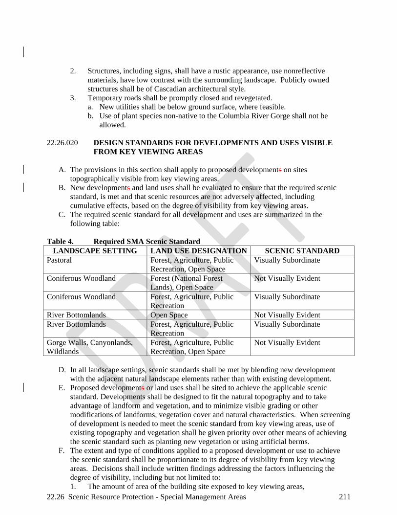
22.26 Scenic Resource Protection - Special Management Areas 211
2. Structures, including signs, shall have a rustic appearance, use nonreflective
materials, have low contrast with the surrounding landscape. Publicly owned
structures shall be of Cascadian architectural style.
3. Temporary roads shall be promptly closed and revegetated.
a. New utilities shall be below ground surface, where feasible.
b. Use of plant species non-native to the Columbia River Gorge shall not be
allowed.
22.26.020 DESIGN STANDARDS FOR DEVELOPMENTS AND USES VISIBLE
FROM KEY VIEWING AREAS
A. The provisions in this section shall apply to proposed developments on sites
topographically visible from key viewing areas.
B. New developments and land uses shall be evaluated to ensure that the required scenic
standard, is met and that scenic resources are not adversely affected, including
cumulative effects, based on the degree of visibility from key viewing areas.
C. The required scenic standard for all development and uses are summarized in the
following table:
Table 4. Required SMA Scenic Standard
LANDSCAPE SETTING LAND USE DESIGNATION SCENIC STANDARD
Pastoral Forest, Agriculture, Public
Recreation, Open Space
Visually Subordinate
Coniferous Woodland Forest (National Forest
Lands), Open Space
Not Visually Evident
Coniferous Woodland Forest, Agriculture, Public
Recreation
Visually Subordinate
River Bottomlands Open Space Not Visually Evident
River Bottomlands Forest, Agriculture, Public
Recreation
Visually Subordinate
Gorge Walls, Canyonlands,
Wildlands
Forest, Agriculture, Public
Recreation, Open Space
Not Visually Evident
D. In all landscape settings, scenic standards shall be met by blending new development
with the adjacent natural landscape elements rather than with existing development.
E. Proposed developments or land uses shall be sited to achieve the applicable scenic
standard. Developments shall be designed to fit the natural topography and to take
advantage of landform and vegetation, and to minimize visible grading or other
modifications of landforms, vegetation cover and natural characteristics. When screening
of development is needed to meet the scenic standard from key viewing areas, use of
existing topography and vegetation shall be given priority over other means of achieving
the scenic standard such as planting new vegetation or using artificial berms.
F. The extent and type of conditions applied to a proposed development or use to achieve
the scenic standard shall be proportionate to its degree of visibility from key viewing
areas. Decisions shall include written findings addressing the factors influencing the
degree of visibility, including but not limited to:
1. The amount of area of the building site exposed to key viewing areas,

22.26 Scenic Resource Protection - Special Management Areas 212
2. The degree of existing vegetation providing screening,
3. The distance from the building site to the key viewing areas from which it is visible,
4. The number of key viewing areas from which it is visible, and
5. The linear distance along the key viewing areas from which the building site is
visible (for linear key viewing areas, such as roads).
G. Conditions may be applied to various elements of proposed developments to ensure they
meet the scenic standard for their setting as seen visible from key viewing areas,
including but not limited to:
1. Siting (location of development on the subject property, building orientation, and
other elements);
2. Retention of existing vegetation;
3. Design (form, line, color, texture, reflectivity, size, shape, height, architectural and
design details and other elements); and
4. New landscaping.
H. Sites approved for new development to achieve scenic standards shall be consistent with
provisions to protect wetlands, riparian corridorswater resources, sensitive rare plants,
Priority Habitats, or sensitive wildlife sites and the buffer zones of each of these natural
resources, and provisions to protect cultural resources.
I. Proposed developments shall not protrude above the line of a bluff, cliff or skyline as
seen visible from key viewing areas.
J. Structure height shall remain below the average tree canopy height of the natural
vegetation adjacent to the structure, except if it has been demonstrated that meeting this
standard is not feasible considering the function of the structure.
K. The following provisions shall apply to new landscaping used to screen development
from key viewing areas:
1. New landscaping (including new earth berms) to achieve the required scenic
standard from key viewing areas shall be required only when application of all other
available provisions in this chapter is not sufficient to make the development meet
the scenic standard from key viewing areas. Development shall be sited to avoid
the need for new landscaping wherever possible.
2. If new landscaping is necessary to meet the required standard, existing on-site
vegetative screening and other visibility factors shall be analyzed to determine the
extent of new landscaping, and the size of new trees needed to achieve the standard.
Any vegetation planted pursuant to this provision shall be sized to provide
sufficient screening to meet the scenic standard within five (5) years or less from
the commencement of construction.
3. Landscaping shall be installed as soon as practicable, and prior to project
completion. Applicants and successors in interest for the subject parcel are
responsible for the proper maintenance and survival of planted vegetation, and
replacement of such vegetation that does not survive.
4. The Scenic Resources Implementation Handbook shall include recommended
species for each landscape setting consistent with the Landscape Settings Design
Provisions in this chapter, and minimum recommended sizes of new trees planted
(based on average growth rates expected for recommended species).
L. Unless expressly exempted by other provisions in this chapter, colors of structures on
sites visible from key viewing areas shall be dark earth-tones found at the specific site or
the surrounding landscape. The specific colors or list of acceptable colors shall be

22.26 Scenic Resource Protection - Special Management Areas 213
included as a condition of approval. The Scenic Resources Implementation Handbook
will include a recommended palette of colors as dark or darker than the colors in the
shadows of the natural features surrounding each landscape setting.
M. The exterior of structures on lands seen from key viewing areas shall be composed of
non-reflective materials or materials with low reflectivity. The Scenic Resources
Implementation Handbook will include a recommended list of exterior materials. Painted
metal is not considered to be non-reflective material or material of low reflectivity.
These recommended materials and other materials may be deemed consistent with this
provision, including those where the specific application meets approval thresholds in the
“Visibility and Reflectivity Matrices” in the Implementation Handbook. Continuous
surfaces of glass unscreened from key viewing areas shall be limited to ensure meeting
the scenic standard. Recommended square footage limitations for such surfaces will be
provided for guidance in the Implementation Handbook.The Scenic Resources
Implementation Handbook includes a list of recommended exterior materials and
screening methods.
N. Exterior lighting shall be sited, limited in intensity, and shielded or hooded in a manner
that prevents lights from being highly visible from key viewing areas and from noticeably
contrasting with the surrounding landscape setting, except for road lighting necessary for
safety purposes.
O. Seasonal lighting displays shall may be permitted on a temporary basis, not to exceed
three months.
P. New buildings greater than 1,500 square feet in area and building additions that will
result in an existing building being increased to greater than 1,500 square feet shall be
compatible with the general scale of existing nearby development of a similar nature.
Findings addressing this requirement shall include:
1. Application of the landscape setting design guidelines.
2. A defined study area surrounding the development that includes at least ten existing
buildings, not including existing buildings within urban areas or outside the
National Scenic Area.
3. Individual evaluations of scale for each separate proposed building in the
application and each separate building in the study area, including:
a. All finished above ground square footage;
b. Total area of covered decks and porches;
c. Attached garages;
d. Daylight basements;
e. Breezeways, if the breezeway shares a wall with an adjacent building; and
f. Dimensions, based on information from the application or in Assessor’s records.
O.4. An overall evaluation demonstrating the proposed development’s compatibility
with surrounding development. Buildings in the vicinity of the proposed
development that are significantly larger in size than the rest of the buildings in the
study area should be removed from this evaluation.
22.26.030 DESIGN STANDARDS FOR DEVELOPMENTS AND USES NOT
VISIBLE FROM KEY VIEWING AREAS.
A. Unless expressly exempted by other provisions in this chapter, colors of structures on
sites not visible from key viewing areas shall be earth-tones found at the specific site.
22.26 Scenic Resource Protection - Special Management Areas 214
The specific colors or list of acceptable colors shall be approved as a condition of
approval, drawing from the recommended palette of colors included in the Scenic
Resources Implementation Handbook.
B. New buildings greater than 1,500 square feet in area and building additions that will
result in an existing building being increased to greater than 1,500 square feet shall be
compatible with the general scale of existing nearby development of a similar nature.
Findings addressing this requirement shall include:
1. Application of the landscape setting design guidelines.
2. A defined study area surrounding the development that includes at least ten existing
buildings, not including existing buildings within urban areas or outside the
National Scenic Area.
3. Individual evaluations of scale for each separate proposed building in the
application and each separate building in the study area, including:
a. All finished above ground square footage;
b. Total area of covered decks and porches;
c. Attached garages;
d. Daylight basements;
e. Breezeways, if the breezeway shares a wall with an adjacent building; and
f. Dimensions, based on information from the application or in Assessor’s records.
4. An overall evaluation demonstrating the proposed development’s compatibility
with surrounding development. Buildings in the vicinity of the proposed
development that are significantly larger in size than the rest of the buildings in the
study area should be removed from this evaluation.
22.26.040 DESIGN STANDARDS FOR KEY VIEWING AREAS FOREGROUNDS
AND SCENIC ROUTES
A. All new developments and land uses immediately adjacent to Washington State Route 14
(SR 14) shall be in conformance with state or county scenic route provisions.
B. Scenic highway corridor strategies shall be developed and implemented for Washington
State Route 14 (SR 14). T, this involves ongoing implementation (and possible updating)
of the associated existing documents.
C. The goals of scenic corridor strategies shall include:
1. Providing a framework for future highway improvements and management that
meet Management Plan scenic provisions and public transportation needs; and
2. Creating design continuity for the highway corridor within the National Scenic
Area. Corridor strategies shall, at minimum, include design provisions (e.g.e.g.,
materials, conceptual designs, etc.) for typical projects that are consistent with
Management Plan scenic resources provisions and an interdisciplinary, interagency
project planning and development process.
D. The following provisions shall apply only to development within the immediate
foregrounds of key viewing areas. Immediate foregrounds are defined as within the
developed prism of a road or trail KVA or within the boundary of the developed area of
KVAs. They shall apply in addition to applicable provisions in Section 22.26.020 (SMA
Provisions for Development Visible from KVAs).
1. The proposed development shall be designed and sited to meet the applicable scenic
standard from the foreground of the subject KVA. If the development cannot meet

22.26 Scenic Resource Protection - Special Management Areas 215
the standard, findings must be made documenting why the project cannot meet the
requirements in Section 22.26.020 and why it cannot be redesigned or wholly or
partly relocated to meet the scenic standard.
2. Findings must evaluate the following:
a. The limiting factors to meeting the required scenic standard and/or applicable
provisions from Section 22.26.020;
b. Reduction in project size;
c. Options for alternative sites for all or part of the project, considering parcel
configuration and on-site topographic or vegetative screening;
d. Options for design changes including changing the design shape, configuration,
color, height, or texture in order to meet the scenic standard.
3. Form, line, color, texture, and design of a proposed development shall be evaluated
to ensure that the development blends with its setting as seen visible from the
foreground of key viewing areas:
a. Form and Line-Design of the development shall minimize changes to the form
of the natural landscape. Development shall borrow form and line from the
landscape setting and blend with the form and line of the landscape setting.
Design of the development shall avoid contrasting form and line that
unnecessarily call attention to the development.
b. Color-Color shall be found in the project’s surrounding landscape setting.
Colors shall be chosen and repeated as needed to provide unity to the whole
design.
c. Texture-Textures borrowed from the landscape setting shall be emphasized in
the design of structures. Landscape textures are generally rough, irregular, and
complex rather than smooth, regular, and uniform.
d. Design-Design solutions shall be compatible with the natural scenic quality of
the Gorge. Building materials shall be natural or natural appearing. Building
materials such as concrete, steel, aluminum, or plastic shall use form, line color
and texture to harmonize with the natural environment. Design shall balance all
design elements into a harmonious whole, using repetition of elements and
blending of elements as necessary
E. Right-of-way vegetation shall be managed to minimize visual impacts of clearing and
other vegetation removal as seen visible from key viewing areas. Roadside vegetation
management (vista clearing, planting, etc.) should enhance views from the highway.
F. Screening from key viewing areas shall be encouraged for existing and required for new
road maintenance, warehouse, and stockpile areas.

22.28 Natural Resource Protection - Special Management Areas 216
CHAPTER 22.28 NATURAL RESOURCE PROTECTION – SPECIAL
MANAGEMENT AREAS
22.28.010 WATER RESOURCE PROTECTION........................................................... 216
22.28.020 WILDLIFE AND PLANT HABITAT PROTECTION .................................. 218
22.28.030 PRACTICABLE ALTERNATIVE TEST ...................................................... 222
22.28.040 NATURAL RESOURCE MITIGATION PLANS ......................................... 223
22.28.010 WATER RESOURCE PROTECTION
A. EXEMPTIONS. Maintenance, repair, reconstruction and realignment of roads and
railroads within their rights of way shall be exempted from application of this chapter
upon demonstration of the following:
1. The wetland within the right of way is a drainage ditch and not part of a larger
wetland outside of the right of way;
2. The wetland is not critical habitat; and
3. Proposed activities within the right of way would not adversely affect a wetland
adjacent to the right of way.
B. BUFFER REQUIREMENTS. All new developments and uses, as described in a site
plan prepared by the applicant, shall be evaluated using the following provisions to
ensure that natural resources are protected from adverse effects. Proposed uses that would
adversely affect water resources (wetlands, streams, ponds, lakes, and riparian areas)
shall be prohibited. Comments from state and federal agencies shall be carefully
considered.
1. All water resources shall, in part, be protected by establishing undisturbed buffer
zones as specified in 22.28.010(B)(4). These buffer zones are measured
horizontally from a wetland, stream, lake, or pond boundary as defined below.
2. The applicant shall be responsible for identifying all water resources and their
appropriate buffers. However, delineations shall be as required in Section
22.28.010(F).
3. All buffer zones shall be retained undisturbed and in their natural condition, except
as permitted with a natural resource mitigation plan, Section 22.28.040.
4. Buffer zones shall be measured outward from the bank full flow boundary for
streams, the high waterhigh-water mark for ponds and lakes, the normal pool
elevation for the Columbia River, and the wetland delineation boundary for
wetlands on a horizontal scale that is perpendicular to the wetlands, stream, pond or
lake boundary. On the main stem of the Columbia River above Bonneville Dam,
buffer zones shall be measured landward from the normal pool elevation of the
Columbia River. The following buffer zone widths shall be required:
a. A minimum 200 foot200-foot buffer on each wetland, pond, lake, and each bank
of a perennial or fish-bearing stream, some of which can be intermittent.
b. A fifty (50)- foot buffer zone along each bank of intermittent (including
ephemeral, non-fish bearing streams).
c. The buffer width shall be increased for the following:
i. When the channel migration zone exceeds the recommended buffer
width, the buffer width shall extend to the outer edge of the channel
migration zone.
22.28 Natural Resource Protection - Special Management Areas 217
ii. When the frequently flooded area exceeds the recommended riparian
buffer zone width, the buffer width shall be extended to the outer edge
of the frequently flooded area.
iii. When an erosion or landslide hazard area exceeds the recommended
width of the buffer, the buffer width shall be extended to include the
hazard area.
5. Buffer zones can be reconfigured if a project applicant demonstrates all of the
following; such features as intervening topography, vegetation, man made features,
natural plant or wildlife habitat boundaries, and flood plain characteristics could be
considered:
a. The integrity and function of the buffer zones is maintained,
b. The total buffer area on the development proposal is not decreased,
c. The width reduction shall not occur within another buffer, and
d. The buffer zone width is not reduced more than fifty percent (50%) at any
particular location.
6. Requests to reconfigure buffer zones shall be considered if an appropriate
professional (botanist, plant ecologist, wildlife biologist, or hydrologist), hired by
the project applicant,
a. Identifies the precise location of the raresensitive wildlife/plant or water
resource,
b. Describes the biology of the raresensitive wildlife/plant or hydrologic condition
of the water resource, and
c. Demonstrates that the proposed use will not have any negative effects, either
direct or indirect, on the affected wildlife/plant and their surrounding habitat
that is vital to their long-term survival or water resource and its long termlong-
term function.
C. The Administrator shall submit all requests to re-configure sensitive rare wildlife/plant or
water resource buffers to the Forest Service and the appropriate state agencies for a
twenty (20) day review. All written comments shall be included in the project file.
Based on the comments from the state and federal agencies, the Administrator will make
a final decision on whether the reconfigured buffer zones are justified. If the final
decision contradicts the comments submitted by the federal and state agencies, the
Administrator shall justify how they reached an opposing conclusion.
D. Buffer zones shall be undisturbed unless the following criteria have been satisfied:
1. The proposed use must have no practicable alternative as determined by the
practicable alternative test, see Section 22.28.030. Those portions of a proposed
use that have a practicable alternative will not be located in wetlands, stream, pond,
lake, and riparian areas and/or their buffer zone.
2. Filling and draining of wetlands shall be prohibited with exceptions related to
public safety or restoration/enhancement activities as permitted when all of the
following criteria have been met:
a. A documented public safety hazard exists or a restoration/ enhancement project
exists that would benefit the public and is corrected or achieved only by
impacting the wetland in question, and
b. Impacts to the wetland must be the last possible documented alternative in
fixing the public safety concern or completing the restoration/enhancement
project, and

22.28 Natural Resource Protection - Special Management Areas 218
c. The proposed project minimizes the impacts to the wetland.
3. Unavoidable impacts to wetlands and aquatic and riparian areas and their buffer
zones shall be offset by deliberate restoration and enhancement or creation
(wetlands only) measures as required by the completion of a mitigation plan.
4. When a buffer zone is disturbed by a new use, it shall be replanted with only native
plant species of the Columbia River Gorge.
E. Proposed uses and development within wetlands, streams, ponds, lakes, riparian areas
and their buffer zones shall be evaluated for cumulative effects to natural resources and
cumulative effects that are adverse shall be prohibited.
F. DELINEATING WATER RESOURCE BOUNDARIES AND BUFFER ZONES.
Wetlands Boundaries shall be delineated using the following:
1. The approximate location and extent of wetlands in the National Scenic Area is
shown on the National Wetlands Inventory (U.S. Department of the Interior 1987).
In addition, the list of hydric soils and the soil survey maps shall be used as an
indicator of wetlands.
2. Some wetlands may not be shown on the wetlands inventory or soil survey maps.
Wetlands that are discovered by the Administrator during an inspection of a
potential project site shall be delineated and protected.
3. The project applicant shall be responsible for determining the exact location of a
wetlands boundary. Wetlands boundaries shall be delineated using the procedures
specified in the ‘1987 Corps of Engineers Wetland Delineation Manual (on-line
eEdition, and applicable regional supplements).
4. All wetlands delineations shall be conducted by a professional who has been trained
to use the federal delineation procedures, such as a soil scientist, botanist, or
wetlands ecologist.
5. Stream, pond, and lake boundaries shall be delineated using the bank full flow
boundary for streams and the high waterhigh-water mark for ponds and lakes. The
project applicant shall be responsible for determining the exact location of the
appropriate boundary for the water resource.
6. The Administrator may verify the accuracy of, and render adjustments to, a bank
full flow, high water mark, normal pool elevation (for the Columbia River), or
wetland boundary delineation. If the adjusted boundary is contested by the project
applicant, the Administrator shall obtain professional services, at the project
applicant's expense, or the Administrator will ask for technical assistance from the
Forest Service to render a final delineation.
22.28.020 WILDLIFE AND PLANT HABITAT PROTECTION
A. REVIEW OF SITE PLANS.
1. Protection of sensitive wildlife/plant areas and sites shall begin when proposed new
developments or uses are within 1,000 feet of a sensitive rare wildlife/ or rare plant
area or siteplant site and/or area. Sensitive Rare wWildlife aAreas are those areas
depicted in wildlife data, including all sensitive wildlife sites and and endemic
plants are those areas listed in Chapter 22.04, the “Types of Wildlife Areas and
Sites Inventoried in the Columbia River Gorge” and “Columbia Gorge Vicinity
Endemic Plant Species” tables, including all Priority Habitats listed in Table 5 in
Section 22.28.020. (USFS) The approximate locations of sensitive rare wildlife
22.28 Natural Resource Protection - Special Management Areas 219
and/or rare plant areas and sites are shown in the wildlife and rare plant
inventorydata. Priority Habitats are defined by the Forest Service and WDFW
through State Wildlife Action Plan efforts.
2. The Administrator shall submit site plans (of uses that are proposed within 1,000
feet of a sensitive rare wildlife and/or rare plant area or site) for review to the Forest
Service and the appropriate state agencies (the Department of Fish & Wildlife for
wildlife issues and the Washington Natural Heritage Program for plant issues).
3. Within twenty (20) days, the Forest Service wildlife biologists and/or botanists, in
consultation with the appropriate state biologists and/or botanists, shall review the
site plan and their field survey records. They shall:
a. Identify/verify the precise location of the wildlife and/or plant area or site,
b. Determine if a field survey will be required,
c. Determine, based on the biology and habitat requirements of the affected
wildlife/plant species, if the proposed use would compromise the integrity and
function of or result in adverse affectsadverse effects (including cumulative
effects) to the wildlife andor plant area or site. This would include considering
the time of year when wildlife andor plant species are sensitive to disturbance,
such as nesting, rearing seasons, or flowering season, and
d. Delineate the undisturbed 200 -foot buffer on the site plan for raresensitive
plants and/or the appropriate buffer for raresensitive wildlife areas or sites,
including nesting, roosting and perching sites.
i. Buffer zones can be reconfigured if a project applicant demonstrates all
of the following:
(1) The integrity and function of the buffer zones is maintained,
(2) The total buffer area on the development proposal is not decreased,
(3) The width reduction shall not occur within another buffer, and
(4) The buffer zone width is not reduced more than fifty percent (50 %) at
any particular location. Such features as intervening topography,
vegetation, man made features, natural plant or wildlife habitat
boundaries, and flood plain characteristics could be considered.
ii. Requests to reduce buffer zones shall be considered if an appropriate
professional (botanist, plant ecologist, wildlife biologist, or hydrologist),
hired by the project applicant,
(1) Identifies the precise location of the raresensitive wildlife/plant or water
resource,
(2) Describes the biology of the sensitive rare wildlife/plant or hydrologic
condition of the water resource, and
(3) Demonstrates that the proposed use will not have any negative effects,
either direct or indirect, on the affected wildlife/plant and their
surrounding habitat that is vital to their long-term survival or to the
water resource and its long termlong-term function.
e. The Forest Service should respond within the twenty (20) day comment period,
even if the reply is as simple as “the agency needs an additional number of days
(Forest Service to specify the number of days) to review this site plan”.
4. The Administrator shall submit all requests to re-configure sensitive rare
wildlife/plant or water resource buffers to the Forest Service and the appropriate
state agencies for review. All written comments shall be included in the record of

22.28 Natural Resource Protection - Special Management Areas 220
application and based on the comments from the state and federal agencies, the
Administrator will make a final decision on whether the reduced buffer zone is
justified. If the final decision contradicts the comments submitted by the federal
and state agencies, the Administrator shall justify how the contrary conclusion was
determined.
5. The Administrator, in consultation with the sState and federal wildlife biologists
and/or botanists, shall use the following criteria in reviewing and evaluating the site
plan to ensure that the proposed developments or uses do not compromise the
integrity and function of or result in adverse eaffects to the wildlife or and plant
area or site:
a. Published provisions regarding the protection and management of the affected
wildlife/plant species. Examples include:
i. The Oregon Department of Forestry technical papers that include
management provisions for osprey and great blue heron;
ii. The Washington Department of Wildlife provisions for a variety of
species, including the western pond turtle, the peregrine falcon, and the
Larch Mountain salamander (Rodrick and Milner 1991).
b. Physical characteristics of the subject parcel and vicinity, including topography
and vegetation.
c. Historic, current, and proposed uses in the vicinity of the raresensitive
wildlife/plant area or site.
d. Existing condition of the wildlife/plant area or site and the surrounding habitat
and the useful life of the area or site.
e. In areas of winter range, habitat components, such as forage and thermal cover,
important to the viability of the wildlife must be maintained or, if impacts are to
occur, enhancement must mitigate the impacts so as to maintain overall values
and function of winter range.
f. The site plan is consistent with published guidance documents such as the
Washington provisions for timing of in-water work.Washington’s Aquatic
Habitat Guidelines (2002 or most recent version).
g. The site plan activities coincide with periods when fish and wildlife are least
sensitive to disturbance. These would include, among others, nesting and
brooding periods (from nest building to fledgling of young) and those periods
specified.
h. The site plan illustrates that new developments and uses, including bridges,
culverts, and utility corridors, shall not interfere with fish and wildlife passage.
i. Maintain, protect, and enhance the integrity and function of Priority Habitats
listed in the following Priority Habitats Table, Table 5. This includes
maintaining structural, species, and age diversity, maintaining connectivity
within and between plant communities, and ensuring that cumulative impacts
are considered in documenting integrity and function.
Table 5. Priority Habitats Table.
Priority Habitats Criteria
Aspen stands High fish and wildlife species diversity, limited availability, high
vulnerability to habitat alteration.

22.28 Natural Resource Protection - Special Management Areas 221
Caves Significant wildlife breeding habitat, limited availability,
dependent species.
Old-growth forest High fish and wildlife density, species diversity, breeding
habitat, seasonal ranges, and limited and declining availability,
high vulnerability.
Oregon white oak
woodlands
Comparatively high fish and wildlife density, species diversity,
declining availability, high vulnerability.
Prairies and steppe Comparatively high fish and wildlife density, species diversity,
important breeding habitat, declining and limited availability,
high vulnerability.
Riparian High fish and wildlife density, species diversity, breeding
habitat, movement corridor, high vulnerability, dependent
species.
Wetlands High species density, high species diversity, important breeding
habitat and seasonal ranges, limited availability, high
vulnerability.
Snags and logs High fish and wildlife density, species diversity, limited
availability, high vulnerability, dependent species.
Talus Limited availability, unique and dependent species, high
vulnerability.
Cliffs Significant breeding habitat, limited availability, dependent
species.
Dunes Unique species habitat, limited availability, high vulnerability,
dependent species.
Winter Range Provides important wintering habitat for deerd and elk.
6. The wildlife/plant protection process may terminate if the Administrator, in
consultation with the Forest Service and state wildlife agency or hHeritage
program, and/or review pursuant to Section 22.28.020(A)(1) through
22.28.020(A)(5), determines:
a. The sensitive rare wildlife area or site is not active, or
b. The proposed use is not within the buffer zones and would not compromise the
integrity of the wildlife/plant area or site, orand
c. The proposed use is within the buffer and could be easily moved out of the
buffer by simply modifying the project proposal (site plan modifications). If the
project applicant accepts these recommendations, the Administrator shall
incorporate them into the staff report and if necessarynecessary, the
administrative decision and the wildlife/plant protection process may conclude.
7. If the above measures fail to eliminate the adverse eaffects, the proposed project
shall be prohibited, unless the project applicant can meet the Practicable Alternative
Test and prepare a natural resource mitigation plan (See Section 22.28.040) to
offset the adverse effects by deliberate restoration and enhancement.
8. The Administrator shall submit a copy of all field surveys (if completed) and
mitigation plans to the Forest Service and appropriate state agencies. The
Administrator shall include all comments in the record of application and address
22.28 Natural Resource Protection - Special Management Areas 222
any written comments submitted by the state and federal wildlife agency/heritage
programs into the staff report and if applicable the administrative decision. Based
on the comments from the state and federal wildlife agency/heritage program, the
Administrator shall make a final decision on whether the proposed use would be
consistent with the wildlife/plant policies and provisions. If the administrative
decision contradicts the comments submitted by the state and federal wildlife
agency/heritage program, the Administrator shall justify how the contrary
conclusion was determined.
9. The Administrator shall require the project applicant to revise the mitigation plan as
necessary to ensure that the proposed use would not adversely affect a sensitive rare
wildlife/plant area or site.
10. Proposed uses and developments within 1,000 feet of sensitive wildlife areas and
sites or within 1,000 feet of rare plants shall be evaluated for cumulative effects to
natural resources and cumulative effects that are adverse shall be prohibited.
B. NATURAL RESOURCE PROTECTION STANDARDS. Soil productivity shall be
protected using the following provisions:
1. A description or illustration showing the mitigation measures to control soil erosion
and stream sedimentation.
2. New developments and land uses shall control all soil movement within the area
shown on the site plan.
3. The soil area disturbed by new development or land uses, except for new
cultivation, shall not exceed fifteen percent (15 %) of the project area.
4. Within one (1) year of project completion, eighty percent (80 %) of the project area
with surface disturbances shall be established with effective native ground cover
species or other soil-stabilizing methods to prevent soil erosion until the area has
eighty percent (80 %) vegetative cover.
22.28.030 PRACTICABLE ALTERNATIVE TEST
An alternative site for a proposed use shall be considered practicable if it is available and the
proposed use can be undertaken on that site after taking into consideration cost, technology,
logistics, and overall project purposes. A practicable alternative does not exist if a project
applicant satisfactorily demonstrates all of the following:
A. The basic purpose of the use cannot be reasonably accomplished using one or more other
sites in the vicinity that would avoid or result in less adverse effects on wetlands, ponds,
lakes, riparian areas, wildlife areas and sites, or plant areas and/or sites;
B. The basic purpose of the use cannot be reasonably accomplished by reducing its proposed
size, scope, configuration, or density, or by changing the design of the use in a way that
would avoid or result in less adverse effects on wetlands, ponds, lakes, riparian areas,
wildlife areas and sites, or plant areas and/or sites; and
C. Reasonable attempts were made to remove or accommodate constraints that caused a
project applicant to reject alternatives to the proposed use. Such constraints include
inadequate infrastructure, parcel size, and land use designations. If a land use designation
or recreation intensity class is a constraint, an applicant must request a Management Plan
amendment to demonstrate that practicable alternatives do not exist.
22.28 Natural Resource Protection - Special Management Areas 223
22.28.040 NATURAL RESOURCE MITIGATION PLANS
A. A mMitigation Pplan shall be prepared when:
1. The proposed development or use is within a buffer zone (wetland, pond, lakes,
riparian areas, or wildlife or plant areas and/or sites); and
2. There is no practicable alternative (see the “practicable alternative” test set out in
Section 22.28.030).
B. In all cases, Mitigation mitigation Plans plans are the responsibility of the applicant and
shall be prepared by an appropriate professional (botanist/ecologist for plant sites, a
wildlife/fish biologist for wildlife/fish sites, and a qualified professional for water
resource sites).
C. The primary purpose of this information is to provide a basis for the project applicant to
redesign the proposed use in a manner that protects the identified sensitive water
resources, and rare wildlife/plant areas and sites, that maximizes his/hertheir development
options, and that mitigates, through restoration, enhancement, creation, and replacement
measures, impacts to the water resources and/or wildlife and /plant area or site and/or
buffer zones.
D. The applicant shall submit the mitigation plan to the Administrator. The Administrator
shall submit a copy of the mitigation plan to the Forest Service, and appropriate state
agencies. If the final decision contradicts the comments submitted by the state and
federal wildlife agency/heritage program, the Administrator shall justify how they
reached an opposing conclusion.
E. A project applicant shall demonstrate sufficient fiscal, technical, and administrative
competence to successfully execute a mitigation plan involving wetland creation.
F. Mitigation plans shall include maps, photographs, and text. The text shall:
1. Describe the biology and/or function of the sensitive protected resources (eg.e.g.,
wildlife/plant species, or wetland) that will be affected by a proposed use. An
ecological assessment of the sensitive protected resource to be altered or
destroyed and the condition of the resource that will result after restoration will
shall be required. Reference published protection and management provisions;
2. Describe the physical characteristics of the subject parcel, past, present, and future
uses, and the past, present, and future potential impacts to the sensitive protected
resources. Include the size, scope, configuration, or density of new uses being
proposed within the buffer zone;
3. Explain the techniques that will be used to protect the sensitive protected
resources and their surrounding habitat that will not be altered or destroyed (for
example, delineation of core habitat of the sensitive rare wildlife/plant species and
key components that are essential to maintain the long-term use and integrity of
the wildlife/plant area or site);
4. Show how restoration, enhancement, and replacement (creation) measures will be
applied to ensure that the proposed use results in minimum feasible impacts to
sensitive protected resources, their buffer zones, and associated habitats; and,
5. Show how the proposed restoration, enhancement, or replacement (creation)
mitigation measures are NOT alternatives to avoidance. A proposed
development/use must first avoid a sensitive protected resource, and only if this is
not possible should restoration, enhancement, or creation be considered as
mitigation. In reviewing mitigation plans, the Administrator, appropriate state

22.28 Natural Resource Protection - Special Management Areas 224
agencies, and the Forest Service shall critically examine all proposals to ensure
that they are indeed last resort options.
G. At a minimum, a project applicant shall provide to the Administrator a progress report
every three (3) years that documents milestones, successes, problems, and contingency
actions. Photographic monitoring stations shall be established and photographs shall be
used to monitor all mitigation progress.
H. A final monitoring report shall be submitted to the Administrator for review upon
completion of the restoration, enhancement, creation, or replacement activity. This
monitoring report shall document successes, problems encountered, resource recovery,
status of any sensitive rare wildlife/plant species and shall demonstrate the success of
restoration and/or enhancement actions. The Administrator shall submit copies of the
monitoring report to the Forest Service; who shall offer technical assistance to the
Administrator in helping to evaluate the completion of the mitigation plan. In instances
where restoration and enhancement efforts have failed, the monitoring process shall be
extended until the applicant satisfies the restoration and enhancement provisions.
I. Mitigation measures to offset impacts to resources and/or buffers shall result in no net
loss of water quality, natural drainage, fish/wildlife/plant habitat, and water resources by
addressing the following:
1. Restoration and enhancement efforts shall be completed no later than one (1) year
after the sensitive protected resource or buffer zone has been altered or destroyed,
or as soon thereafter as is practicable;
2. All natural vegetation within the buffer zone shall be retained to the greatest extent
practicable. Appropriate protection and maintenance techniques shall be applied,
such as fencing, conservation buffers, livestock management, and noxious weed
control. Within five years, at least seventy-five percent (75 %) of the replacement
vegetation must shall survive. All plantings must shall be with native plant species
that replicate the original vegetation community;
3. Habitat that will be affected by either temporary or permanent uses shall be
rehabilitated to a natural condition. Habitat shall be replicated in composition,
structure, and function, including tree, shrub and herbaceous species, snags, pool-
riffle ratios, substrata, and structures, such as large woody debris and boulders;
4. If this standard is not feasible or practical because of technical constraints, a
sensitive protected resource of equal or greater benefit may be substituted, provided
that no net loss of sensitive protected resource functions occurs and provided the
Administrator, in consultation with the appropriate State state and Federal federal
agency, determines that such substitution is justified;
5. Sensitive Rare plants that will be destroyed altered shall be transplanted or replaced,
to the maximum extent practicable. Replacement is used here to mean the
establishment of a particular plant species in areas of suitable habitat not affected by
new uses. Replacement may be accomplished by seeds, cuttings, or other
appropriate methods. Replacement shall occur as close to the original plant site as
practicable. The project applicant shall ensure that at least seventy-five percent (75
%) of the replacement plants survive three (3) years after the date they are planted;
6. Wetland creation mitigation shall be deemed complete when the wetland is self-
functioning for five (5) consecutive years. Self-functioning is defined by the
expected function of the wetland as written in the mitigation plan. The monitoring
report shall be submitted to the Administrator to ensure compliance. The Forest
22.28 Natural Resource Protection - Special Management Areas 225
Service, in consultation with appropriate state agencies, shall extend technical
assistance to the Administrator to help evaluate such reports and any subsequent
activities associated with compliance;
7. Wetland restoration/enhancement can be mitigated successfully by donating
appropriate funds to a non-profit wetland conservancy or land trust with explicit
instructions that those funds are to be used specifically to purchase protection
easements or fee title protection of appropriate wetlands acreage in or adjacent to
the Columbia River Gorge meeting the ratios given above in Section
22.28.040(I)(17). These transactions shall be explained in detail in the Mitigation
mitigation Plan plan and shall be fully monitored and documented in the monitoring
report; and,
8. Nonstructural controls and natural processes shall be used to the greatest extent
practicable.
9. Bridges, roads, pipeline and utility corridors, and other water crossings shall be
minimized and should serve multiple purposes and properties.
10. Stream channels shall not be placed in culverts unless absolutely necessary for
property access. Bridges are preferred for water crossings to reduce disruption to
hydrologic and biologic functions. Culverts shall only be permitted if there are no
practicable alternatives as demonstrated by the ‘Practicable Alternative Test’.
11. Fish passage shall be protected from obstruction.
12. Restoration of fish passage should occur wherever possible.
13. Show location and nature of temporary and permanent control measures that shall
be applied to minimize erosion and sedimentation when riparian areas are disturbed,
including slope netting, berms and ditches, tree protection, sediment barriers,
infiltration systems, and culverts.
14. Groundwater and surface water quality will not be degraded by the proposed use.
Natural hydrologic conditions shall be maintained, restored, or enhanced in such a
manner that replicates natural conditions, including current patterns (circulation,
velocity, volume, and normal water fluctuation), natural stream channel and
shoreline dimensions and materials, including slope, depth, width, length, cross-
sectional profile, and gradient.
15. Those portions of a proposed use that are not water-dependent or that have a
practicable alternative willshall be located outside of stream, pond, and lake buffer
zones.
16. Streambank and shoreline stability shall be maintained or restored with natural
revegetation.
17. The size of restored, enhanced, and replacement (createdion) wetlands shall equal
or exceed the following ratios. The first number specifies the required acreage of
replacement wetlands, and the second number specifies the acreage of wetlands
altered or destroyed.
a. Restoration. 2: l
b. Creation. 3: l
c. Enhancement. 4: l

22.30 Cultural Resource Protection - Special Management Areas 226
CHAPTER 22.30 CULTURAL RESOURCE PROTECTION – SPECIAL
MANAGEMENT AREAS
22.30.010 GENERAL PROVISIONS FOR IMPLEMENTING THE
CULTURAL RESOURCE PROTECTION PROCESS ..........................226
22.30.020 CULTURAL RESOURCE ARCHAEOLOGICAL AND HISTORIC
SURVEYS ...............................................................................................231
22.30.030 EVALUATION OF SIGNIFICANCE .....................................................232
22.30.040 ASSESSMENT OF EFFECT ..................................................................234
22.30.050 MITIGATION PLANS ............................................................................235
22.30.060 CULTURAL RESOURCES DISCOVERED AFTER
CONSTRUCTION BEGINS ...................................................................236
22.30.070 DISCOVERY OF HUMAN REMAINS .................................................237
22.30.0280 ASSESSING POTENTIAL EFFECTS TO CULTURAL
RESOURCES ..........................................................................................237
22.30.010 GENERAL PROVISIONS FOR IMPLEMENTING THE CULTURAL
RESOURCE PROTECTION PROCESS
A. All cultural resource information shall remain confidential and exempt from public
records requests, according to Section 6(a)(1)(A) of the National Scenic Area Act and
RCW 42.17.310(k). Federal agency cultural resource information is also confidential and
exempt by statue from the Freedom of Information Act under 16 USC 470 hh and 36
CFR 296.18.
B. All cultural resource surveys, evaluations, assessments and mitigation plans shall be
performed by professionals whose expertise reflects the type of cultural resources that are
involved. Principal investigators shall meet the professional standards set out in 36 Code
of Federal Regulations (CFR), Part 61 and in Guidelines for Evaluating and Documenting
Traditional Cultural Properties (Parker and King, no date).
C. The Forest Service will be responsible for performing the literature review and
consultation, inventory, evaluations of significance, assessments of effect, and mitigation
requirements in Section 22.30.080 020 for forest practices and National Forest Systems
lands.
D. New Developments developments or land uses shall not adversely affect significant
cultural resources.
E. The procedures in Section 22.30.020, 030, 040, 050, 060, and 070Chapter 22.22 (Cultural
Resource Protection – General Management Areas) shall be used to review all proposed
developments and land uses other than those on all federal lands, federally assisted
projects and forest practices.
F. The procedures in Section 22.30.080 020 and guidelines in 36 CFR 800 shall be used by
the Administrator and federal agencies to evaluate new developments or land uses on
federal lands, federally assisted projects, and forest practices.
F.
G. Cultural resource surveys, evaluations, assessments, and mitigation plans shall generally
be conducted in consultation with Indian tribal governments and if appropriate, any party
of record. Indian tribal governments shall be consulted if the affected cultural resources
are prehistoric or otherwise associated with Native Americans. If the cultural resources

22.30 Cultural Resource Protection - Special Management Areas 227
are associated with non-Native Americans, such as a historic house or pioneer campsite,
the Indian tribal governments do not have to be consulted.
H. The responsibility and cost of preparing an evaluation of significance, assessment or
effect, or mitigation plan shall be borne by the project applicant, except for resources
discovered during construction and forest practices. The Gorge Commission shall
conduct and pay for evaluations of significance and mitigation plans for resources that
are discovered during construction of small-scale and large-scale uses.
I. ARCHAEOLOGICAL AND HISTORIC SURVEYS AND SURVEY REPORTS.
1. ARCHAEOLOGICAL SURVEY REQUIREMENTS AND EXCEPTIONS.
a. An archaeological survey shall be required for all proposed uses within 500 feet
of a known cultural resource, including those uses listed as exempt in Section
22.30.010(I)(1)(b).
b. An archaeological survey shall be required for all proposed uses, except the
following, unless located within 500 feet of a known cultural resource:
i. The modification, expansion, replacement, or reconstruction of existing
buildings and structures.
ii. Proposed uses that would not disturb the ground, including land
divisions and lot-line adjustments, storage shed that do not require a
foundation; low-intensity recreation uses, such as fishing, hunting and
hiking; installation of surface chemical toilets; hand treatment of brush
within established rights-of-way; and new uses of existing structures.
iii. Proposed uses that involve minor ground disturbance, as defined by
depth and extent, including repair and maintenance of lawfully
constructed serviceable structures; home gardens; livestock grazing;
cultivation that employs minimum tillage techniques, such as replanting
pastures using a grassland drill; construction of fences; new utility poles
that are installed using an auger, post-hole digger or similar implement;
and placement of mobile homes where septic systems and underground
utilities are not involved. The Gorge Commission shall review all land
use applications and determine if the proposed uses would have a minor
ground disturbance.
iv. Proposed uses that occur on sites that have been disturbed by human
activities, provided the proposed uses do not exceed the depth and extent
of existing ground disturbance. To qualify for this exception, a project
applicant must demonstrate that land-disturbing activities occurred in the
project area. Land-disturbing activities include grading and cultivation.
v. Proposed uses that would occur on sites that have been adequately
surveyed in the past. Past surveys must have been conducted by a
qualified professional and must include a surface survey and subsurface
testing. The nature and extent of any cultural resources in the project
area must be adequately documented. The project applicant must
demonstrate that the project area has been adequately surveyed.
vi. Proposed uses occurring in areas that have a low probability of
containing cultural resources. Areas that have a low probability of
containing cultural resources shall be identified using the results of
archaeological surveys conducted by the Columbia River Gorge
Commission, the United States Forest Service, public agencies and

22.30 Cultural Resource Protection - Special Management Areas 228
private archaeologists. The Gorge Commission, after consultation with
the Indian tribes and Washington State Department of Archaeology and
Historical Preservation (hereinafter DAHP), shall prepare and adopt a
map showing areas that have a low probability of containing cultural
resources. This map shall be adopted within 200 days after the Secretary
of Agriculture concurs with the Management Plan. The maps referred to
above shall be refined and revised as additional archaeological surveys
are conducted. Areas shall be added or deleted as warranted. All
revisions of this map shall be reviewed and approved by the Gorge
Commission. The following proposed uses do not qualify for this
exemption:
(1) Residential development that involves two or more new dwellings for
the same project applicant.
(2) Recreation facilities that contain parking areas for more than ten cars,
overnight camping facilities, boat ramps and visitor information and
environmental education facilities.
(3) Public transportation facilities that are outside improved rights-of-way.
(4) Electric facilities, lines, equipment and appurtenances that are thirty-
three (33) kilovolts or greater.
(5) Communications, water and sewer, and natural gas transmission (as
opposed to distribution) lines, pipes, equipment and appurtenances.
c. A historic survey shall be required for all proposed uses that would alter the
exterior architectural appearance of buildings and structures that are fifty (50)
years old or older, or would compromise features of the surrounding area that
are important in defining the historic or architectural character of buildings or
structures that are fifty (50) years old or older.
d. The Gorge Commission shall conduct and pay for all archaeological and historic
surveys for small-scale uses in the General Management Area. When
archaeological resources or traditional cultural properties are discovered, the
Gorge Commission also shall identify the approximate boundaries of the
resource or property and delineate a reasonable buffer zone. Archaeological
surveys and buffer zone delineations for large-scale uses shall be the
responsibility of the project applicant.
e. Large-scale uses, for the purposes of this Chapter, include residential
development involving two or more new dwellings; all recreation facilities;
commercial and industrial development; public transportation facilities; electric
facilities, lines, equipment, and appurtenances that are thirty-three (33) kilovolts
or greater; and communications, water and sewer, and natural gas transmission
(as opposed to distribution) lines, pipes, equipment , and appurtenances.
f. Archaeological Surveys for small-scale uses shall generally include a subsurface
survey and subsurface testing. They shall meet the following standards:
i. A surface survey of the project area shall be conducted, except for
inundated areas and impenetrable thickets.
ii. Subsurface testing shall be conducted if the surface survey reveals that
cultural resources may be present. Subsurface probes shall be placed at
intervals sufficient to determine the absence or presence of cultural
resources.

22.30 Cultural Resource Protection - Special Management Areas 229
g. Archaeological Survey Reports for small-scale uses shall be documented in a
confidential report that includes:
i. A description of the fieldwork methodology used to identify cultural
resources, including a description of the type and extent of the
archaeological survey.
ii. A description of any cultural resources that were discovered in the
project area, including a written description and photographs.
iii. A map that shows the project area, the areas surveyed, the location of
subsurface probes, and, if applicable, the approximate boundaries of the
affected cultural resources and a reasonable buffer zone.
iv. All written comments and consultation meeting minutes, if applicable,
shall be incorporated into the archaeological survey report.
h. Archaeological Surveys for large-scale uses shall be designed by a qualified
professional. They shall meet the following requirements:
i. A written description of the survey shall be submitted to and approved
by the Gorge Commission’s designated archaeologist.
ii. Archaeological surveys shall reflect the physical characteristics of the
project area and the design and potential effects of the proposed use.
i. Archival research shall be performed before any field work. Archival research
shall include a thorough examination of tax records; historic maps, photographs
and drawings; previous archaeological, historic and ethnographic research;
cultural resource inventories and records maintained by federal, state and local
agencies; and primary historic accounts, such as diaries, journals, letters and
newspapers.
j. Surface surveys shall include the entire project area, except for inundated areas
and impenetrable thickets.
k. Subsurface probes shall be placed at intervals sufficient to document the
presence or absence of cultural resources.
l. Archaeological site inventory forms shall be submitted to the Washington State
Department of Archeology and Historic Preservation (hereinafter "DAHP")
whenever cultural resources are discovered.
m. Archaeological Survey Reports for large-scale uses shall be documented in a
confidential report that includes:
i. A description of the proposed use, including drawings and maps.
ii. A description of the project area, including soils, vegetation, topography,
drainage, past alterations and existing land use.
iii. A list of the documents and records examined during the archival
research and a description of any prehistoric or historic events associated
with the project area.
iv. A description of the fieldwork methodology used to identify cultural
resources, including a map that shows the project area, the areas
surveyed, and the location of subsurface probes. The map shall be
prepared at a scale of one (1) inch equals 100 feet (1:1200) or a scale
providing greater detail.
v. Copies of all written comments submitted by Indian tribal governments
and other interested persons.

22.30 Cultural Resource Protection - Special Management Areas 230
vi. An inventory of the cultural resources that exist in the project area,
including a written description, photographs, drawings and a map. The
map shall be prepared at a scale of one (1) inch equals 100 feet
(1:1,200), or a scale providing greater detail.
vii. A preliminary assessment of whether the proposed use would or would
not have an effect on cultural resources. The assessment shall
incorporate concerns and recommendations voiced during consultation
meetings and information, if any, obtained through field surveys.
2. HISTORIC SURVEYS AND REPORTS.
b. Historic surveys shall document the location, form, style, integrity and physical
condition of historic buildings and structures. They shall include original
photographs and maps. Archival research, blueprints and drawings should be
used as necessary.
c. Historic surveys shall describe any uses that will alter or destroy the exterior
architectural appearance of the historic buildings or structures, or compromise
features of the site that are important in defining the overall historic character of
the historic buildings or structures.
d. The project applicant shall provide detailed architectural drawings and building
plans that clearly illustrate all proposed alterations.
e. Historic surveys shall include copies of all written comments and consultation
meeting minutes submitted by Indian tribal governments and other parties of
record, if applicable.
f. Cultural resources are significant if one of the following criteria is satisfied:
i. The cultural resources are included in, or eligible for inclusion in the
National Register of Historic Places. The criteria for evaluation the
eligibility of cultural resources for National Register of Historic Places
appear in the “National Register Criteria for Evaluation” (36 CFR 60.4).
ii. The cultural resources are determined to be culturally significant by an
Indian tribal government, based on criteria developed by that Indian
tribal government and filed with the Gorge Commission.
b. CULTURAL ADVISORY COMMITTEE (CAC).
a. The Columbia River Gorge Commission shall establish a Cultural Advisory
Committee (CAC). The CAC shall comprise cultural resource professionals,
interested individuals, and at least one representative from each of the four
Indian tribal governments.
b. If a project applicant’s and an Indian tribal government’s evaluations of
significance contradict, then the CAC shall review the applicant’s evaluation
and the Indian tribal government's substantiated concerns. The Indian tribal
government shall substantiate its concerns in a written report.
c. Within thirty (30) days of delivery by the Administrator of a contested
evaluation of significance to the CAC, the CAC shall submit a written
recommendation to the Administrator as to whether affected cultural resources
are significant and its reasons for making a determination of significance. If the
CAC fails to submit a written recommendation within the said thirty (30) days,
then the Administrator shall determine that the CAC concurs in the applicant's
evaluation of significance.

22.30 Cultural Resource Protection - Special Management Areas 231
22.30.020 CULTURAL RESOURCE ARCHAEOLOGICAL AND HISTORIC
SURVEYS
A. CONSULTATION AND ETHNOGRAPHIC RESEARCH.
1. When written comments including a request for consultation with the applicant, are
submitted to the Administrator by a party of record within the twenty (20) day
development review comment period, the project applicant shall offer to meet with
the requesting party within ten (10) calendar days. The ten (10) day consultation
period may be extended upon agreement between the project applicant and the
requesting party.
2. Consultation meetings should provide an opportunity for the requesting party to
explain how the proposed use may affect cultural resources. Recommendations to
avoid potential conflicts should be discussed.
3. A project applicant who is proposing a large-scale use shall conduct interviews and
other forms of ethnographic research if a party of record submitted a written request
for such research. All requests must include a description of the cultural resources
that may be affected by the proposed use and the identity of knowledgeable
informants. Ethnographic research shall be conducted by qualified specialists.
Tape recordings, maps, photographs, and minutes of the meetings shall be used
when appropriate.
4. All written comments, consultation meeting minutes, and ethnographic research
shall be incorporated into the archaeological or historic survey report. In instances
where a survey is not required, all such information shall be recorded and addressed
in a report that typifies a survey report; inapplicable elements may be omitted.
B. NOTICE OF SURVEY RESULTS.
1. The Administrator shall submit a copy of all cultural resource survey reports to
DAHP and to the Indian tribal governments. Survey reports may include measures
to avoid potentially affected resources, such as a map that shows a reasonable
buffer zone.
2. DAHP and the Indian tribal governments shall have thirty (30) calendar days from
the date a survey report is mailed to submit written comments to the Administrator.
3. The Administrator shall retain in the record and address all written comments in the
Administrative Decision and Staff Report.
C. CONCLUSION OF CULTURAL RESOURCE PROTECTION PROCESS.
1. The Administrator shall make a final decision on whether the proposed use would
be consistent with the provisions of this Chapter. If the final decision contradicts
the comments submitted by the DAHP, the Administrator shall justify how the
opposing conclusion was determined.
2. The cultural resource protection process may conclude when the Administrator
makes a final, written determination that one of the following conditions exists:
a. The proposed use does not require an archaeological or historic survey, no
cultural resources are known to exist in the project area, and no substantial
concerns were voiced by parties of record within the comment period on the
application.
b. An archaeological survey demonstrates that cultural resources do not exist in the
project area and no substantiated concerns were raised in written comments
submitted by parties of record within the twenty (20) day comment period on

22.30 Cultural Resource Protection - Special Management Areas 232
the application, and no substantiated concerns regarding the archaeological
survey were submitted by DAHP or Indian tribal governments during the thirty
(30) calendar day comment period as required by 22.30.020(B).
c. The proposed use would avoid archaeological resources and traditional cultural
resources that exist in the project area. A reasonable buffer has been established
around the affected resources or property and all ground-disturbing activities
shall be prohibited within the buffer zone. Buffer zones shall preserve the
integrity and context of cultural resources. Buffer zones may vary in width
depending on the eventual use of the project area, the type of cultural resources
present and the characteristics for which the cultural resources may be
significant. A deed covenant, easement or other appropriate mechanism shall be
developed to ensure that the buffer zone and the cultural resources are protected.
An evaluation of significance shall be conducted if a project applicant decides
not to avoid the affected cultural resource. In these instances, the
archaeological survey and survey report shall be incorporated into the
evaluation of significance.
d. The historic survey conducted by the Gorge Commission may provide sufficient
information to satisfy Section 22.30.030(D) If it does not, architectural and
building plans, photographs and archival research may be required. The project
applicant shall be responsible for providing information beyond that included in
the survey conducted by the Gorge Commission. The historic survey and report
must demonstrate that these provisions have been clearly and absolutely
satisfied. If the DAHP or the Administrator question whether these provisions
have been satisfied, the project applicant shall conduct an evaluation of
significance. A historic survey demonstrates that the proposed use would not
have an adverse effect on historic buildings or structures because:
i. DAHP concludes that the historic or architectural character of the
affected buildings or structures are not significant, as determined using
the criteria in the "National Register Criteria for Evaluation" (36 CFR
60.4), or
ii. The proposed use would not compromise the historic or architectural
character of the affected buildings or structures, or compromise features
of the site that are important in defining the overall historic character of
the affected buildings or structures, as defined by provisions and
standards in The Secretary of the Interior's Standards for Rehabilitation
(U.S. Department of the Interior 1990) and the Secretary of the Interior's
Standards for Historic Preservation Projects (U.S. Department of the
Interior 1983).
22.30.030 EVALUATION OF SIGNIFICANCE
A. EVALUATION CRITERIA AND INFORMATION NEEDS. If cultural resources
would be affected by a proposed use, an evaluation of their significance shall be
conducted. Evaluations of significance shall meet the following requirements:
1. Evaluations of significance shall follow the procedures set out in How to Apply the
National Register Criteria for Evaluation (U.S. Department of Interior, no date) and

22.30 Cultural Resource Protection - Special Management Areas 233
Guidelines for Evaluating and Documenting Traditional Cultural Properties (Parker
and King, no date).
2. Evaluations of significance shall be presented within local and regional contexts
and shall be guided by previous research and current research designs that are
relevant to specific research questions for the Columbia River Gorge.
3. The evaluation of significance shall follow the principles, guidelines and report
format recommended by the Washington State Department of Archaeology and
Historic Preservation (DAHP, no date).
4. The evaluation of significance shall incorporate the results of the archaeological or
historic survey and shall illustrate why each cultural resource found is or is not
significant. Findings shall be presented within the context of relevant local and
regional research. All documentation used to support the evaluation of significance
shall be cited. Information gathered during the archaeological or historic survey
may have to be supplemented. Detailed field mapping, subsurface testing,
photographic documentation, laboratory analyses, and archival research may be
required.
5. The project applicant shall contact Indian tribal governments and parties of record,
as appropriate. Ethnographic research shall be undertaken as necessary to fully
evaluate the significance of the cultural resources.
6. All documentation used to support the evaluation of significance shall be cited.
Evidence of consultation with Indian tribal governments and other parties of record
shall be presented. All comments, recommendations and correspondence from
Indian tribal governments and interested persons shall be appended to the
evaluation of significance.
B. NOTICE OF EVALUATION RESULTS.
1. If the evaluation of significance demonstrates that the cultural resources are not
significant, then the Administrator shall submit a copy of the evaluation of
significance to DAHP and the Indian tribal governments.
2. DAHP, the Indian tribal governments and requesting persons shall have 30 calendar
days from the date the evaluation of significance is mailed to submit written
comments to the Administrator. The Administrator shall retain in the record and
address all written comments in the Administrative Decision and Staff Report.
C. CULTURAL RESOURCES ARE CULTURALLY SIGNIFICANT.
1. If an Indian tribal government believes that the affected cultural resources are
culturally significant, contrary to the evaluation submitted by the project applicant,
then the CAC shall make an independent review of the applicant’s evaluation and of
the Indian tribal government's substantiated concerns. The CAC shall formulate a
recommendation regarding the significance of the cultural resources.
2. The Indian tribal governments shall substantiate their concerns, if any, in a written
report which shall be submitted to the Administrator, the CAC and the project
applicant within 15 calendar days from the date the evaluation of significance is
mailed. The CAC shall submit its recommendation to the Administrator within 30
calendar days from the date the evaluation of significance is mailed.
D. CONCLUSION OF THE CULTURAL RESOURCE PROTECTION PROCESS.
1. The Administrator shall make a final decision on whether the affected resources are
significant. If the final decision contradicts the comments or recommendations
22.30 Cultural Resource Protection - Special Management Areas 234
submitted by DAHP or CAC, the Administrator shall justify how an opposing
conclusion was reached.
2. The cultural resource protection process shall conclude if the affected cultural
resources are not significant.
3. If the project applicant or the Administrator determines that the cultural resources
are significant, then the effects of the proposed use shall be assessed.
22.30.040 ASSESSMENT OF EFFECT
A. ASSESSMENT CRITERIA AND INFORMATION NEEDS. If a proposed use could
potentially affect significant cultural resources, an assessment shall be made to determine
if it would have no effect, no adverse effect, or an adverse effect. The assessment shall
meet the following requirements:
1. The assessment of effect shall be conducted and paid for by the project applicant.
2. The assessment of effect shall be based on the criteria published in "Protection of
Historic Properties" (36 CFR 800.5) and shall incorporate the results of the
archaeological or historic survey and the evaluation of significance. All
documentation shall follow the requirements listed in 36 CFR 800.11.
3. Proposed uses are considered to have an effect on cultural resources when they alter
or destroy characteristics of the resources that make them significant [36 CFR
800.5].
4. Proposed uses are considered to have an adverse effect when they may diminish the
integrity of the cultural resource's location, design, setting, materials and
workmanship, feeling or association [36 CFR 800.5]. Adverse effects include, but
are not limited to:
a. Physical destruction, damage or alteration of all or part of the cultural resource.
b. Isolation of the cultural resource from its setting or alteration of the character of
the resource's setting when that character contributes to the resource's
qualification as being significant.
c. Introduction of visual, audible or atmospheric elements that are out of character
with the cultural resource or its setting.
d. Neglect of a significant cultural resource resulting in its deterioration or
destruction, except as described in 36 CFR 800.5.
5. The assessment of effect shall be prepared in consultation with Indian tribal
governments and parties of record, if appropriate. The concerns and
recommendations written by Indian tribal governments and parties of record shall
be recorded and addressed in the assessment.
6. The effects of a proposed use that would otherwise be determined to be adverse
may be considered to be not adverse if any of the following applies:
a. The cultural resources are of value only for their potential contribution to
archaeological, historical or architectural research, and when such value can be
substantially preserved through the conduct of appropriate research before
development begins, and such research is conducted in accordance with
applicable professional standards and guidelines.
b. The undertaking is limited to the rehabilitation of buildings and structures, and
is conducted in a manner that preserves the historical and architectural character
of affected cultural resources through conformance with The Secretary of the
22.30 Cultural Resource Protection - Special Management Areas 235
Interior's Standards for Rehabilitation (U.S. Department of Interior 1990) and
The Secretary of the Interior's Standards for Historic Preservation Projects (U.S.
Department of Interior 1983).
B. NOTICE OF ASSESSMENT RESULTS.
1. If the assessment of effect concludes that the proposed use would have no effect or
no adverse effect on significant cultural resources, the Administrator shall submit a
copy of the assessment to DAHP and affected Indian tribal governments, if any.
2. DAHP, affected Indian tribal governments and parties of record, if appropriate,
shall have thirty (30) calendar days from the date the assessment is mailed to submit
written comments to the Administrator. The Administrator shall record and address
all written comments in the Administrative Decision and Staff Report.
C. CONCLUSION OF THE CULTURAL RESOURCE PROTECTION PROCESS.
1. The Administrator shall make a written decision on whether the proposed use
would have no effect, no adverse effect or an adverse effect. If the decision
contradicts the comments submitted by DAHP, the Administrator shall justify how
the opposing conclusion was determined.
2. The cultural resource protection process shall conclude if the proposed use would
have no effect or no adverse effect on significant cultural resources.
3. A mitigation plan shall be prepared if a project applicant or the Administrator
determines that the proposed use will have an adverse effect on significant cultural
resources.
22.30.050 MITIGATION PLANS
A. MITIGATION PLAN CRITERIA AND INFORMATION NEEDS. If the
Administrator concludes that the proposed use would have an adverse effect on
significant cultural resources, then a mitigation plan shall be prepared. Mitigation plans
shall meet the following requirements:
1. Mitigation plans shall be prepared and paid for by the project applicant.
2. Mitigation plans shall reduce an adverse effect to no effect or no adverse effect.
3. Mitigation plans shall be prepared in consultation with persons who have concerns
about or knowledge of the affected cultural resources, including Indian tribal
governments, Native Americans, local governments whose jurisdiction
encompasses the project area, and DAHP.
4. Avoidance of cultural resources through project design and modification is
preferred. Avoidance may be achieved by reducing the size, scope, configuration
and density of the proposed use. Alternative mitigation measures shall be used only
if avoidance is not practicable. Alternative measures include, but are not limited to,
burial under fill, stabilization, removal of the cultural resource to a safer place and
partial to full excavation and recordation. If the mitigation plan includes buffer
zones to protect cultural resources, a deed covenant, easement or other appropriate
mechanism shall be developed and recorded in the County Auditor's records.
5. Mitigation plans shall incorporate the results of the archaeological or historic
survey, the evaluation of significance and the assessment of effect, and shall
provide the following documentation required in 36 CFR 800.11, including but not
limited to:

22.30 Cultural Resource Protection - Special Management Areas 236
a. A description and evaluation of any alternatives or mitigation measures that the
project applicant proposes for reducing the effects of the proposed use.
b. A description of any alternatives or mitigation measures that were considered
but not chosen and the reasons for their rejection.
c. Documentation that all notice, comment and consultation provisions of this Title
have been met.
d. A description of the project applicant’s efforts to obtain and consider the views
of Indian tribal governments, parties of record and the Administrator.
e. Copies of any written recommendations submitted to the Administrator or
applicant regarding the effects of the proposed use on cultural resources and
alternatives to avoid or reduce those effects.
B. NOTICE OF MITIGATION PLAN RESULTS.
1. If the Administrator concludes that a mitigation plan reduces the effect of a use
from an adverse effect to no effect or no adverse effect, the Administrator shall
submit a copy of the mitigation plan to DAHP and affected Indian tribal
governments.
2. DAHP, affected Indian tribal governments and parties of record shall have thirty
(30) calendar days from the date the mitigation plan is mailed to submit written
comments to the Administrator. The Administrator shall retain in the record and
address all written comments in the Administrative Decision and Staff Report.
C. CONCLUSION OF THE CULTURAL RESOURCE PROTECTION PROCESS.
1. The Administrator shall make a final decision of whether the mitigation plan would
reduce an adverse effect to no effect or no adverse effect. If the final decision
contradicts the comments submitted by DAHP, the Administrator shall justify how
the opposing conclusion was reached.
2. The cultural resource protection process shall conclude if a mitigation plan will
reduce an adverse effect to no effect or no adverse effect.
3. The proposed use shall be prohibited when acceptable mitigation measures fail to
reduce an adverse effect to no effect or no adverse effect.
22.30.060 CULTURAL RESOURCES DISCOVERED AFTER CONSTRUCTION
BEGINS
The following procedures shall be effected when cultural resources are discovered during
construction activities. All survey and evaluation reports and mitigation plans shall be submitted
to the Administrator and DAHP. Indian tribal governments also shall receive a copy of all
reports and plans if the cultural resources are prehistoric or otherwise associated with Native
Americans.
A. HALT OF CONSTRUCTION. All construction activities within 100 feet of the
discovered cultural resource shall cease. The cultural resources shall remain as found;
further disturbance is prohibited.
B. NOTIFICATION. The project applicant shall notify the Administrator and the Gorge
Commission within twenty-four (24) hours of the discovery. If the cultural resources are
prehistoric or otherwise associated with Native Americans, the project applicant shall
also notify the Indian tribal governments within twenty-four (24) hours.
C. SURVEY AND EVALUATIONS. The Gorge Commission shall survey the cultural

22.30 Cultural Resource Protection - Special Management Areas 237
resources after obtaining written permission from the landowner and appropriate permits
from the DAHP. (See Revised Code of Washington 27.53.) It shall gather enough
information to evaluate the significance of the cultural resources. The survey and
evaluation shall be documented in a report that generally follows the provisions in the
Section 22.30.030 of this Chapter. Based upon the survey and evaluation report and any
written comments, the Administrator shall make a final decision on whether the resources
are significant. A mitigation plan shall be prepared if the affected cultural resources are
significant. Construction activities may recommence if the cultural resources are not
significant.
D. MITIGATION PLAN. Mitigation plans shall be prepared according to the information,
consultation and report provisions contained in the Section 22.30.050 of this Chapter.
Construction activities may recommence when the conditions in the mitigation plan have
been executed.
22.30.070 DISCOVERY OF HUMAN REMAINS
The following procedures shall be effected when human remains are discovered during a cultural
resource survey or during construction. Human remains means articulated or disarticulated
human skeletal remains, bones or teeth, with or without attendant burial artifacts.
A. HALT OF ACTIVITIES. All survey, excavation and construction activities shall cease.
The human remains shall not be disturbed any further.
B. NOTIFICATION. Local law enforcement officials, the Administrator, the Gorge
Commission, and the Indian tribal governments shall be contacted immediately.
C. INSPECTION. The county coroner, or appropriate official, shall inspect the remains at
the project site and determine if they are prehistoric/historic or modern. Representatives
of the Indian tribal governments shall be contacted immediately.
D. JURISDICTION. If the remains are modern, the appropriate law enforcement officials
shall assume jurisdiction and the cultural resource protection process may conclude.
E. TREATMENT. The procedures set out in RCW 27.44 and 68.05 shall generally be
implemented if the remains are prehistoric/historic. If human remains will be reinterred
or preserved in their original position, a mitigation plan shall be prepared in accordance
with the consultation and report requirements set out in Section 22.30.050 of this
Chapter. The mitigation plan shall accommodate the cultural and religious concerns of
Native Americans. The cultural resource protection process may conclude when the
conditions set forth in Section 22.30.030(D) of this Chapter are met and the mitigation
plan is executed.
22.30.020080 ASSESSING POTENTIAL EFFECTS TO CULTURAL RESOURCES
The following procedures as well as the provisions in 36 CFR 800 shall be used to assess
potential effects to cultural resources on federal lands, federally assisted projects, and forest
practices:
A. LITERATURE REVIEW AND CONSULTATION.

22.30 Cultural Resource Protection - Special Management Areas 238
1. An assessment shall be made to determine if any cultural resources listed on the
National Register of Historic Places at the national, state, or local level are present
on or within the area of potential direct and indirect impact.
2. A search shall be made of state and County government, National Scenic
Area/Forest Service and any other pertinent inventories, such as archives and
photographs, to identify cultural resources. The search shall include consultation
with the Washington State Department of Archeology and Historic Preservation
(DAHP) and tribal governments. State and tribal governments response to the
consultation request shall be allowed for thirty (30) days.
3. Cultural resource professionals knowledgeable about the area shall be consulted.
4. A field inventory by a cultural resource professional shall be required if the Forest
Service or the Administrator determines that a recorded or known cultural resource
exists on or within the immediate vicinity of a new development or land use,
including those reported in consultation with the Indian tribal governments.
B. FIELD INVENTORY.
1. Tribal representatives shall be invited to participate in the field inventory.
2. The field inventory shall conform to one (1) of the following standards, as
determined by the cultural resource professional:
a. Complete survey: The systematic examination of the ground surface through a
controlled procedure, such as walking an area in evenly spaced transects. A
complete survey may also require techniques such as clearing of vegetation or
augering or shovel probing of subsurface soils for the presence of buried
cultural resources.
b. Sample survey: The sampling of an area to assess the potential of cultural
resources within the area of proposed development or use. This technique is
generally used of parcels that are large or difficult to survey, and is generally
accomplished by a stratified random or non-stratified random sampling strategy.
A parcel is stratified either by variables such as vegetation, topography or
elevation, or by non-environmental factors such as a survey grid. Under this
method, statistically valid samples are selected and surveyed to indicate the
probability of presence, numbers and types of cultural resources throughout the
sampling strata. Depending on the results of the sample, a complete survey may
or may not subsequently be recommended.
3. A field inventory report shall be required and shall include the following:
a. A narrative integrating the literature review with the field inventory.
b. A description of the field inventory methodology used. The description shall
include the type and extent of field inventory and shall be supplemented by
maps that graphically illustrate the areas surveyed supplemented by maps that
graphically illustrate the areas surveyed and not surveyed and provide the
rationale for each.
c. A statement of the presence or absence of cultural resources within the area of
the new development or land use.
d. When cultural resources are not located, a statement of the likelihood of buried
or otherwise concealed cultural resources. Recommendations and standards for
monitoring, if appropriate, shall be included.
4. The report shall follow the format specified by the Washington State Department of
Archaeology and Historic Preservation (DAHP).

22.30 Cultural Resource Protection - Special Management Areas 239
5. The field inventory report shall be presented to the Forest Service for review.
C. EVALUATION OF SIGNIFICANCE.
1. When cultural resources are found within the area of the new development or land
use, an evaluation of significance shall be completed for each cultural resource in
accordance with the criteria of the National Register of Historic Places (36 CFR
60.4).
2. Evaluations of cultural resource significance shall be guided by previous and
current research designs relevant to specific research questions for the area.
3. Evaluations of the significance of traditional cultural properties shall follow
National Register Bulletin 38, "Provisions for the Evaluation and Documentation of
traditional Cultural Properties", within local and regional contexts.
4. Recommendations for eligibility to the National Register shall be completed for
each identified resource, in accordance with National Register criteria A through D
(36 CFR 60.4). The Forest Service or the Administrator shall review evaluations
for adequacy.
5. Evidence of consultation with tribal governments and individuals with knowledge
of the cultural resources in the project area, and documentation of their concerns,
shall be included as part of the evaluation of significance.
6. An assessment of effect shall be required if the Forest Service or the Administrator
determines that the inventoried cultural resources are significant.
D. ASSESSMENT OF EFFECT.
1. For each significant (i.e., eligible for the National Register) cultural resource
inventoried within the area of the proposed development or change in use,
assessments of effect shall be completed, using the criteria outlined in 36 CFR
800.5. Evidence of consultation with tribal governments and individuals with
knowledge of the cultural resources of the project area shall be included for
Sections 22.30.0280(D)(2) through 22.30.0280(D)(4). The Forest Service shall
review each determination for adequacy.
2. If the proposed development or change in use will have "no adverse effect", as
defined in 36 CFR 800.4, to a significant cultural resource, documentation for that
finding shall be completed, following the "Documentation Requirements" of 36
CFR 800.11. If the proposed development or change in use will have an effect then
criteria of adverse effect must be applied (36 CFR 800.5).
3. If the proposed development or change in use will have an "adverse effect", as
defined in 36 CFR 800.5, to a significant cultural resource, the type and extent of
"adverse effect” upon the qualities of the property that make it eligible for the
National Register shall be documented [36 CFR 800.6 “Resolution of Adverse
Effects”]. This documentation shall follow the process outlined under 36 CFR
800.11 (“Failure to Resolve Adverse Effects”).
4. If the "effect" appears to be beneficial (i.e., an enhancement to cultural resource),
recommendations shall be documented concerning the beneficial effects upon the
qualities of the cultural resource that make it eligible for the National Register.
This documentation shall follow the process outlined under 36 CFR 800.11
(“Documentation Standards”).
E. MITIGATION.
1. If there will be an effect on cultural resources, mitigation measures shall be
provided (36 CFR 800.6 “Resolution of Adverse Effects”). Mitigation measures
22.30 Cultural Resource Protection - Special Management Areas 240
that shall be considered include avoidance of the property through project design or
modification and subsequent protection, burial under fill, data recovery excavations
or other appropriate measures.
2. Evidence of consultation with tribal governments and individuals with knowledge
of the affected resources, and documentation of their concerns, shall be included for
all mitigation proposals.
3. The Forest Service or Administrator shall review all mitigation proposals for
adequacy.
F. DISCOVERY DURING CONSTRUCTION.
1. All authorizations for new developments or land uses shall be conditioned to
require the immediate notification of the Forest Service or the Administrator if
cultural resources are discovered during construction or development.
2. If cultural resources are discovered, particularly human bone or burials, work in the
immediate area of discovery shall be suspended until a cultural resource
professional can evaluate the potential significance of the discovery and
recommend measures to protect and/or recover the resources.
3. If the discovered material is suspected to be human bone or a burial, the following
procedure shall be used:
a. The applicant shall stop all work in the vicinity of the discovery.
b. The applicant shall immediately notify the Administrator, the Forest Service,
the applicant’s cultural resource professional, the State Medical Examiner, and
the appropriate law enforcement agencies.
c. The Forest Service or Administrator shall notify the Indian tribal governments if
the discovery is determined to be an Indian tribal burial or a cultural resource.
d. A cultural resource professional shall evaluate the potential significance of the
resource pursuant to Section 22.30.0280(C) and report the results to the Forest
Service or Administrator.
4. The cultural resource review process shall be complete and work may continue if
the Forest Service or the Administrator determines that the cultural resource is not
significant.
5. The cultural resource professional shall recommend measures to protect and/or
recover the resource pursuant to Section 22.30.0280(E) if the Forest Service or
Administrator determines that the cultural resource is significant.

22.32 Recreational Resource Protection - Special Management Areas 241
CHAPTER 22.32 RECREATIONAL RESOURCE PROTECTION – SPECIAL
MANAGEMENT AREAS
22.32.010 APPROVAL STANDARDS ...................................................................241
22.32.020 RECREATION INTENSITY CLASSES ................................................241
22.32.010 APPROVAL STANDARDS
The following standards shall apply to all new development and land uses in the Special
Management Area:
A. New developments and land uses shall not displace existing recreational use.
B. Recreation resources shall be protected from adverse effects by evaluating new
developments and land uses as proposed in the site plan. An analysis of both onsite and
offsite cumulative effects shall be required.
C. New pedestrian or equestrian trails shall not have motorized uses, except for emergency
services.
D. Mitigation measures shall be provided to preclude adverse effects on the recreation
resource.
E. Provisions governing facilitiesThe facility design guidelines are intended to apply to
individual recreation facilities. For the purposes of those provisions, a cluster or
grouping of recreational developments or improvements located relatively close to one
another is considered an individual recreation facility. Developments or improvements
within the same Rrecreation Iintensity Cclass are considered as separate facilities if they
are separated by at least a quarter (¼) mile of undeveloped land, excluding trails,
pathways or access roads.
F. New development and reconstruction of scenic routes shall include provisions for bicycle
lanes, whenever feasible.
22.32.020 RECREATION INTENSITY CLASSES
Each Recreation Intensity Class includes a description of the desired social, physical, and
managerial setting for recreation development within each Recreation Intensity Class. Each
Recreation Intensity Class also includes a list of allowable uses, subject to compliance with the
approval standards set out in Section 22.32.020(E) hereof.
A. RECREATION INTENSITY CLASS 1 (VERY LOW INTENSITY).
1. Social Setting: Visitors in this designation have a high chance of finding solitude
and opportunities to experience activities that rely on self-reliance, challenge and
risk. Encounters with other visitors is low throughout the designation. Perceived
crowdedness is low to non-existent away from roads recreation sites. Visitor
encounters and perceived crowdedness is low to moderate at or near (within 1 mile)
roads and recreation sites.
2. Physical and Managerial Setting: Predominately natural/ or natural appearing
landscapes with rustic improvements characterize this designation. Nodes of
developed recreation facilities may be allowed. Developed recreation site
regulations and controls (signing, regulations or other regimentation) are noticeable

22.32 Recreational Resource Protection - Special Management Areas 242
but harmonize with the natural characteristics of the landscape setting. Away from
developed recreation sites there is minimal or subtle control of users.
3. Trail development is simple and typically accommodate low use levels. Users are
highly skilled with a high degree of orienteering skills.
4. The maximum design capacity for parking areas shall be ten (10) vehicles.
1. Permitted uses are those in which people participate in outdoor activities to realize
experiences such as solitude, tension reduction and nature appreciation.
2. The maximum site design capacity shall not exceed thirty-five (35) people at one
time on the site. The maximum design capacity for parking areas shall be ten (10)
vehicles.
3.5. The following uses may be permitted:
a. Trails and trailheads.
b. Parking areas.
c. Dispersed campsites accessible only by a trail.
d. Viewpoints and overlooks.
e. Picnic areas.
f. Signs.
g. Interpretive exhibits and displays.
h. Restrooms.
h.i. Accommodations for mass transportation facilities should be considered where
compatible with the social and physical settings.
B. RECREATION INTENSITY CLASS 2 (LOW INTENSITY).
1. Social Setting: This designation is characterized by opportunities to experience
relaxation, physical fitness and outdoor learning and where there is a moderate
probability to experience solitude. Visitor encounters are low to moderate on trails
and away from developed recreation sites and roads. Usually and moderate to high
near (within 1 mile) recreation sites and roads.
2. Physical and Managerial Setting: Predominately natural or natural appearing
landscapes with rustic improvements characterize this designation. Nodes of highly
developed recreation facilities may be allowed. Developed recreation site
regulations and controls (signing, regulations or other regimentation) harmonize
with the natural characteristics of the landscape setting. Away from developed
recreation sites there is minimal or subtle control of users.
3. Trails are moderately developed (native surface or gravel, trail bridges and other
facilities are provided for user convenience). Trail use is typically low to moderate.
Trails are suitable for a wide range of users and are challenging and involve
intermediate to advance skills.
4. The maximum design capacity for parking areas shall be twenty-five (25) vehicles.
1. Permitted uses are those that provide settings where people can participate in
activities such as physical fitness, outdoor learning, relaxation and escape from
noise and crowds.
2. The maximum site design capacity shall not exceed seventy (70) people at one time
on the site. The maximum design capacity for parking areas shall be twenty-five
(25) vehicles.
3.5. The following uses may be permitted:All uses permitted in Recreation Intensity
Class 1 are permitted in Class 2, along with the following uses:
a. All uses permitted in Recreation Intensity Class 1 are permitted in Class 2.

22.32 Recreational Resource Protection - Special Management Areas 243
b. Campgrounds for twenty (20) units or less, tent site only.
a. with vehicle access.
b.c. Boat anchorages designed for no more than ten (10) boats at one time.
d. Swimming areas.
c.e. Accommodations for mass transportation facilities should be considered where
compatible with the social and physical settings.
C. RECREATION INTENSITY CLASS 3 (MODERATE INTENSITY).
1. Social Setting: A high degree of interaction with other visitors with opportunities to
experience relaxation and activities that provide little challenge or risk in a natural
appearing environment characterizes this designation. Visitor encounters are
moderate to high on trails away from developed recreation sites and roads.
2. Physical and Managerial Setting: Changes to the natural landscape may be evident
but in harmony with natural characteristics of the landscape setting. Highly
developed recreation facilities and trails are constructed for visitor convenience.
On-site regulation and controls are noticeable but harmonize with the natural
environment.
3. Trails typically accommodate moderate to high use and are well developed (native,
gravel or paved surfaces, trail facilities such as bridges are provided for
convenience). Trails are easily traveled by a wide range of users who have
intermediate skill level and minimal orienteering skills.
1.4. Permitted uses are those in which people can participate in activities to realize
experiences such as group socialization, nature appreciation, relaxation, cultural
learning and physical activity.
2.5. The maximum site design capacity shall not exceed 250 people at one time on the
site. The maximum design capacity for parking areas shall be fifty (50) vehicles.
The General Management Area vehicle capacity level of seventy-five (75) vehicles
shall be allowed if enhancement or mitigation measures for scenic, cultural or
natural resources are approved for at least ten percent (10 %) of the site.
3.6. Accommodation of facilities for mass transportation (bus parking, etc.) shall be
required for all new Recreation Intensity Class 3 day-use recreation sites and
improvements to existing Class 3 day-use recreation sites where the improvement
would increase the use of the site, except for sites predominantly devoted to boat
access. The number and size of the mass transportation facilities shall reflect the
physical capacity of the site.
4.7. All uses permitted in Recreation Intensity Classes 1 and 2 are permitted in Class 3,
along with the following:
a. Campgrounds with improvements that may include water, power, sewer and
sewage dump stations. Campgrounds shall not exceed a combination of fifty
(50) single or group campsites (tent or recreational vehicle) and a total design
capacity of 250 people at one time.
b. Boat anchorages designed for not more than fifteen (15) boats.
c. Public visitor, interpretative, historic and environmental education facilities.
d. Full-service restrooms that may include showers.
e. Boat ramps.
f. Riding stables.
D. RECREATION INTENSITY CLASS 4 (HIGH INTENSITY).

22.32 Recreational Resource Protection - Special Management Areas 244
1. Social Setting: This designation is characterized by highly developed facilities
where there is little challenge or risk associated with being in the outdoors. There is
a high degree of interaction with other visitors. Encounters are high in recreation
sites, on roads and trails within in this designation.
2. Physical and Managerial Setting: Landscapes with natural appearing backdrop are
characterized by this designation. Highly developed recreation facilities and trails
are constructed for visitor convenience and ease of movement. On-site regulation
and controls are noticeable but harmonize with the natural characteristics of the
landscape setting.
3. Trails are highly developed (gravel or paved surfaces, trail facilities such as bridges
are provided for convenience) and accommodate heavy to intensive use. Users are
typically inexperienced with little or no orienteering skills. Trails are easily traveled
by a wide range of users.
1.4. Permitted uses are those in which people can participate in activities to realize
experiences such as socialization, cultural and natural history appreciation and
physical activity.
2.5. The maximum design capacity shall not exceed 1,000 people at one time on the site.
The maximum design capacity for parking areas shall be 200 vehicles. The General
Management Area vehicle capacity level of 250 vehicles shall be allowed if
enhancement or mitigation measures for scenic, cultural or natural resources are
approved for at least twenty percent (20 %) of the site.
3.6. Accommodation of facilities for mass transportation (bus parking, etc.) shall be
required for all new Recreation Intensity Class 4 day-use recreation sites and
improvements to existing Class 4 day-use recreation sites where the improvement
would increase the use of the site, except for sites predominantly devoted to boat
access, except for sites predominantly devoted to boat access. The number and size
of the mass transportation facilities shall reflect the physical capacity of the site.
7. All uses permitted in Recreation Intensity Classes 1, 2 and 3 are permitted in Class
4. The following uses may also be permitted:
4.a. Campgrounds with improvements that may include vehicle access, water,
power, sewer, and sewage dump stations. Campgrounds shall not exceed a
combination of 100 single or group campsites (tent or recreational vehicle) and
a total design capacity of 500 people at one time.
E. DESIGN STANDARDS FOR RECREATION USES.
1. Recreation facilities that are not resource-based may be included at sites providing
resource-based recreation uses consistent with the provisions of this Chapter, as
long as such facilities comprise no more than one-third of the total land area
dedication to the recreation use or facilities.
2. The facility design standards are intended to apply to individual recreation facilities.
Developments or improvements within the same Recreation Intensity Class are
considered as separate facilities if they are separated by at least a quarter (¼) mile
of undeveloped land, excluding trails, pathways or access roads.
3. Existing vegetation, particularly mature trees shall be maintained to the maximum
extent practicable. These trees may be used to satisfy requirements for perimeter
and interior landscaped buffers.
4. Parking areas providing over fifty (50) spaces shall be divided into discrete
"islands" separated by unpaved, landscaped buffer areas.

22.32 Recreational Resource Protection - Special Management Areas 245
5. Lineal frontage of parking areas and campsite loops on scenic travel corridors shall
be minimized.
6. Ingress and egress points shall be consolidated to the maximum extent practicable
consistent with provision of adequate emergency access pursuant to applicable fire
and safety codes.
7. Signs shall be limited to those necessary to provide relevant recreation or facility
information, interpretive information, vehicular and pedestrian direction and for
safety purposes.
8. Innovative designs and materials that reduce visual impacts (such as "turf blocks"
instead of conventional asphalt paving) shall be encouraged through incentives such
as additional allowable parking spaces and reduced required minimum interior or
perimeter landscaped buffers. If potential visual impacts have been substantially
reduced by use of such designs and materials, then the Administrator may allow
either:
a. Reductions up to fifty percent (50%) percent of required minimum interior or
perimeter landscape buffers or,
b. Up to ten percent (10%) additional parking spaces.
9. A majority of trees, shrubs and other plants in landscaped areas shall be species
native to the landscape setting in which they occur. Project applicants that are
required to use new landscaping are encouraged to place trees, shrubs, and other
plans in a manner approximating their natural condition.
10. For any parking area with over fifty (50) spaces, interior landscaped buffers
breaking up continuous areas of parking into discrete “islands” shall be provided.
The minimum width of interior landscaped buffers separating each subarea of fifty
(50) spaces or less shall be twenty (20) feet.
11. Grading or soil compaction within the "drip line" of existing mature trees shall be
avoided to the maximum extent practicable, to reduce risk of root damage and
associated tree mortality.
12. Project applicants shall use measures and equipment necessary for the proper
maintenance and survival of all vegetation used to meet landscape standards and
shall be responsible for such maintenance and survival.
13. All parking areas shall be set back from property boundaries by at least fifty (50)
feet. All campsites and associated facilities shall be set back from property
boundaries by at least 100 feet.
F. VARIANCES. Variances may be granted to the parking and campground unit
provisions under Recreation Intensity Class 4 listed in Section 22.32.020(D) of up to ten
percent (10%) upon demonstration that all of the following conditions exist:
1. Demand and use levels for the proposed activity(ies) or activities, particularly in the
area where the site is proposed, are high and expected to remain so and/or increase.
Statewide Comprehensive Outdoor Recreation Plan (SCORP) data and data from
Scenic Area recreation demand studiesthe National Visitor Use Monitoring
Program shall be relied upon to meet this criterion in the absence of current
applicable studies.
2. The proposed use is dependent on resources present at the site.
3. Reasonable alternative sites offering similar opportunities, including those in
nearby uUrban Aareas, have been evaluated, and it has been demonstrated that the
proposed use cannot be adequately accommodated elsewhere.

22.32 Recreational Resource Protection - Special Management Areas 246
4. The proposed use is consistent with the goals, objectives, and policies in this
chapter.
5. Through site design and/or mitigation measures, the proposed use can be
implemented without adversely affecting scenic, cultural, or natural resources and
adjacent land uses.
6. Through site design and/or mitigation measures, the proposed use can be
implemented without affecting or modifying treaty rights.
7. Mass transportation shall be considered and implemented, if feasible, for all
proposed variances to Recreational Intensity Class 4.

22.34 Emergency Management Provisions 247
CHAPTER 22.34 EMERGENCY MANAGEMENT PROVISIONS
22.34.010 EMERGENCY MANAGEMENT ACTIONS AND
NOTIFICATION .....................................................................................247
22.34.020 EMERGENCY MANAGEMENT ACTIONS – BEST
MANAGEMNENT PRACTICES ...........................................................248
22.34.030 POST EMERGENCY/DIASTER RESPONSE -
APPLICATION .......................................................................................249
22.34.040 POST-EMERGENCY/DISASTER RESPONSE
DEVEOLOPMENT REVIEW - GMA/SMA PROVISIONS -
SCENIC RESOURCES ...........................................................................250
22.34.050 POST-EMERGENCY/DISASTER RESPONSE
DEVEOLOPMENT REVIEW - GMA/SMA PROVISIONS -
CULTURAL RESOURCES AND TREATY RIGHTS ..........................252
22.34.060 POST-EMERGENCY/DISASTER RESPONSE
DEVEOLOPMENT REVIEW - GMA/SMA PROVISIONS -
NATURAL RESOURCES - WATER .....................................................254
22.34.070 POST-EMERGENCY/DISASTER RESPONSE
DEVEOLOPMENT REVIEW - GMA/SMA PROVISIONS -
NATURAL RESOURCES - WILDLIFE. ...............................................255
22.34.080 POST-EMERGENCY/DISASTER RESPONSE
DEVEOLOPMENT REVIEW - GMA/SMA PROVISIONS -
NATURAL RESOURCES - RARE PLANTS ........................................256
22.34.090 POST-EMERGENCY/DISASTER RESPONSE
DEVEOLOPMENT REVIEW - GMA/SMA PROVISIONS -
RECREATIONAL RESOURCES ...........................................................257
22.34.100 POST-EMERGENCY CONSTRUCTION ..............................................258
22.34.010 EMERGENCY MANAGEMENT ACTIONS AND NOTIFICATION
Actions taken in response to an emergency/disaster event are allowed in all GMA/SMA
land use designations, subject to the following notification requirements:
A. Notification of an emergency/disaster response activity shall be submitted either
within forty-eight (48) hours of the commencement of a response action, or by the
next business day following the start of such an action, whichever is sooner.
Notification shall be submitted by the party conducting an emergency/disaster
response activity or their representatives. In the case of multiple responding
parties, the first party to respond shall provide the required notification, unless,
upon mutual agreement of responding parties, another responder elects to assume
this responsibility.
B. Notification shall be submitted by mail, fax, telephone, e-mail or in person. If
notification occurs by telephone, a hard copy of the notification shall be submitted
by mail or in person within seven (7) days.
C. Notification shall be furnished to the Administrator or the Forest Service for
federal agency actions.

22.34 Emergency Management Provisions 248
D. At a minimum, the following information shall be required at the time of
notification:
1. Nature of emergency/disaster event.
2. Description of emergency/disaster response activities and magnitude of
response actions to be taken, if applicable (such as extent of earth
movement, erection of structures, etc.)
3. Location of emergency/disaster response activities.
4. Estimated start and duration of emergency/disaster response activities.
5. Contact person and phone number for the parties conducting
emergency/disaster response actions.
E. Repair and maintenance of an existing serviceable structure to its previously
authorized and undamaged condition are not subject to the above referenced
notification requirements.
F. Upon notification of any emergency/disaster response action, the Administrator
shall, as soon as possible:
1. Review the natural resource inventory data and notify the contact person for
the emergency/disaster response actions of all inventoried natural resource
sites, and their buffers, that are within or adjacent to the response areas or
that may be adversely affected by response activities;
2. Notify the Washington Department of Fish Wildlife of all noticed
emergency/disaster response actions, to provide them an opportunity to
consult with responding agencies during the event, and;
3. Notify the Forest Service (except when the Forest Service is the notifying
agency), Washington State Department of Archeology and Historic
Preservation (DAHP), and the Tribal governments of all emergency/disaster
response activities. The Forest Service will review their cultural resource
inventory data and notify the contact person for the emergency/disaster
response action as soon as possible of all inventoried cultural resource sites,
or their buffers, that are within, or adjacent to, emergency/disaster response
areas.
G. Upon notification of a response action, the Forest Service shall, as soon as
possible, offer the services of a resource advisor to the agency(ies) conducting the
response action. The resource advisor will provide on-site advice to minimize
impacts to resources from emergency/disaster response actions.
22.34.020 EMERGENCY MANAGEMENT ACTIONS – BEST
MANAGEMENT PRACTICES
A. Following emergency/disaster response actions, best management practices
(BMPs) to prevent sedimentation and provide erosion control shall be utilized
whenever disaster response actions necessitate vegetation removal, excavation,
and/or grading. BMPs may include, but are not limited to:
1. Straw bales,
4.2. Slash windrows,
5.3. Filter fabric fences,
6.4. Sandbags,
22.34 Emergency Management Provisions 249
7.5. Straw cover,
8.6. Jute netting.
B. Structures or development installed or erected for a temporary use (e.g.e.g.,
sandbags, check dams, plastic sheeting, chain link fences, debris walls, etc.) shall
be removed within one year following an emergency event. If it can be
demonstrated that the continued use of these devices is necessary to protect life,
property, public services or the environment, an extension of no more than two
years may be granted by the Administrator or the Forest Service for federal
agency actions.
C. The new exploration, development (extraction or excavation), and production of
mineral resources, used for commercial, private or public works projects, shall not
be conducted as an emergency/disaster response activity.
D. No spoils resulting from grading or excavation activities shall be deliberately
deposited into a wetland, stream, pond, lake, or riparian area within the National
Scenic Area (NSA) as part of an emergency/disaster response action. The only
exception to this is for construction of a fire line during a wildfire, where avoiding
the aquatic area or its buffer zone has been considered and determined to not be
possible without further jeopardizing life or property.
22.34.030 POST EMERGENCY/DISASTER RESPONSE - APPLICATION
Post-Emergency/Disaster Response Application Requirements shall be as follows:
A. Within thirty (30) days following notification, a post-emergency/disaster response
application shall be submitted by the party conducting the response action to the
Administrator or Forest Service for federal agency actions. In the case of an event
with multiple responding parties, the agency providing initial notification as
required herein shall submit the application. An exception to this may occur if
another responding party, by mutual agreement with the other respondents, elects
to submit the application. Requests to extend this submittal deadline may be made
in writing and shall include the reason why an extension is necessary. Extensions
shall not exceed thirty (30) days in duration and no more than two (2) extensions
shall be granted..
B. Post-emergency/disaster response applications shall only address development
activities conducted during an emergency/disaster response. Applications shall
specify if development placed during an emergency/disaster event is permanent or
temporary. Applicants shall be responsible for operations under their control and
that of other responders, upon mutual agreement. The terms Development
Activities and Development include the disposal of any spoil materials associated
with an emergency/disaster response action. Responders not agreeing to have
another responder address their actions shall be responsible to submit an
application for those actions.
C. Emergency/disaster response actions not involving structural development or
ground disturbance with mechanized equipment are exempt from these
requirements, except for those actions within 500 feet of a known cultural
resource (as determined in the notification process).
22.34 Emergency Management Provisions 250
D. APPLICATIONS SHALL INCLUDE THE FOLLOWING
INFORMATION:
1. Applicant’s name and address.
2. Location of emergency/disaster response.
3. A written description of the emergency/disaster response, including any
structures erected, excavation or other grading activities, or vegetation
removal.
4. A map of the project area drawn to scale, at a scale of one (1) inch equals
200 feet (1:2,400) or a scale providing greater detail. The map shall include:
a. North arrow and scale;
b. Boundaries, dimensions and size of subject parcel(s);
c. Bodies of water, watercourses, and significant landforms;
d. Existing roads and structures; and
e. New structures placed and any vegetation removal, excavation or
grading resulting from the response actions.
f. An exception to the scale requirements of 22.34.030(D)(4), may be
granted for an event encompassing an area greater than one square mile.
In such cases, a clear sketch map of the entire response action area shall
be provided. In addition, a map of one (1) inch equals 200 feet (1:2,400)
or a scale providing greater detail shall be provided that shows a section
of the response area exemplifying the specific actions taken.
5. Emergency/disaster response review uses may be allowed pursuant to a
process that provides at minimum the following:
a. Notice of the application to landowners within 500 feet of the perimeter
of the subject parcel, the Forest Service, Gorge Commission, the four
Tribal governmentsColumbia River treaty tribes, and interested parties.
b. A written decision with findings of fact and conclusions of law.
c. An opportunity to request an appeal hearing.
22.34.040 POST-EMERGENCY/DISASTER RESPONSE DEVELOPMENT
REVIEW - GMA/SMA PROVISIONS - SCENIC RESOURCES
Actions taken in all land use designations within the GMA/SMA that are in response to
an emergency/disaster event, as defined above, shall be reviewed for compliance with the
following provisions:
A. Impacts of emergency/disaster response actions shall be evaluated to ensure that
scenic resources are not adversely affected. In the GMA, such actions shall be
rendered visually subordinate in their landscape setting as seen visible from key
viewing areas to the greatest extent practicable, except for actions located in areas
exempted from visual subordinance requirements (Section 22.18.0210(AB)). In
the SMA, such actions shall meet the scenic standard to the greatest extent
practicable.
B. Vegetation shall be used to screen or cover road cuts, structural development,
landform alteration, and areas denuded of vegetation, as a result of
emergency/disaster response actions.

22.34 Emergency Management Provisions 251
C. Areas denuded of vegetation as a result of emergency/disaster response actions
shall be revegetated with native plant species, or species commonly found within
the applicable landscape setting, to restore the affected areas to its pre-response
condition to the greatest extent practicable. Revegetation shall occur as soon as
practicable, but not later than one (1) year after the emergency/disaster event. An
exception to the one (1)-year requirement may be granted upon demonstration of
just cause, with an extension of up to one (1) year.
D. The painting, staining or use of other materials on new structural development
shall be used to ensure that the structures are non-reflective, or of low reflectivity,
and visually subordinate in their landscape setting as seen visible from key
viewing areas, unless the structure is fully screened from key viewing areas by
existing topographic features.
E. Additions to existing structures, resulting from an emergency/disaster response
action, which are smaller in total height, bulk or area than the existing structures
may be the same color as the existing development. Additions larger than the
existing development shall be visually subordinate in their landscape setting as
seen visible from key viewing areas to the greatest extent practicable.
F. In the General Management Area, spoil materials associated with grading,
excavation and slide debris removal activities in relation to an emergency/disaster
response action, shall comply with the following standards:
1. The Administrator shall determine which of the options in Section
22.34.040(F)(2) shall be implemented by the applicant according to the
following criteria:
a. The option in Section 22.34.040(F)(2) shall be the one which, to the
greatest extent practicable, best complies with the provisions of this Title
that protect scenic, cultural, recreation, and natural resources.
b. Disposal sites created according to Section 22.34.040(F)(2)(b) shall only
be used for spoil materials associated with an emergency/disaster
response action. Spoil materials from routine road maintenance
activities shall not be deposited at these sites.
2. The spoil materials shall either be:
a. Removed from the NSANational Scenic Area;
b. Deposited at a site within the NSA National Scenic Area permitted by
the Administrator;
c. (Re)contoured, to the greatest extent practicable, to retain the natural
topography which emulates that of the surrounding landscape;
G. In the Special Management Area, spoils materials associated with grading,
excavation and slide debris removal activities in relation to an emergency/disaster
response action shall comply with the following standards:
1. The spoils material shall either be:
a. Removed from the NSANational Scenic Area, or
b. Deposited at a site within the NSA National Scenic Area permitted by
the Administrator, within two (2) years of the emergency.
2. After the spoils materials are removed, the emergency disposal site shall be
rehabilitated to meet the scenic standards.

22.34 Emergency Management Provisions 252
3. All grading (i.e., recontouring) shall be completed within thirty (30) days
after the spoils materials are removed.
4. Sites shall be replanted using native plants found in the landscape setting or
ecoregion to the maximum extent practicable.
5. All revegetation shall take place within one (1) year of the date an applicant
completes the grading.
6. This provision shall take affect two (2) years after the date of Management
Plan concurrence by the US Secretary of Agriculture (May 10, 2004), or
approval of a disposal site, which everwhichever comes first.
22.34.050 POST-EMERGENCY/DISASTER RESPONSE DEVELOPMENT
REVIEW - GMA/SMA PROVISIONS - CULTURAL RESOURCES
AND TREATY RIGHTS
Actions taken in all land use designations within the GMA/SMA that are in response to
an emergency/disaster event, as defined above, shall be reviewed for compliance with the
following provisions:
A. To the greatest extent practicable, emergency/disaster response actions shall not
adversely affect cultural resources. Emergency/disaster response actions shall not
affect or modify tTribal treaty rights.
B. The USDA Forest Service shall determine if an archaeological survey or historic
survey is necessary within three (3) days after receiving notice that a post-
emergency land use application has been received by the Administrator.
1. Archaeological surveys and reports shall be conducted by the USDA Forest
Service and comply with the standards in Sections 22.22.010020(E)(g and i)
for GMA and 22.30.010(I)(f and m) for SMA.
2. Historic surveys shall be conducted by the USDA Forest Service and shall
describe any adverse effects to historic resources resulting from an
emergency/disaster response action. Historic surveys shall document the
location, form, style, integrity, and physical condition of historic buildings
and structures. Such surveys shall also include original photographs, if
available, and maps, and should use archival research, blueprints, and
drawings as necessary.
C. Following the submittal of a post-emergency land use application, in addition to
other public notice requirements that may exist, the Tribal tribal governments
shall be notified by the Administrator when:
1. An archaeological survey is required; or
2. Cultural resources exist in the project area.
a. Notices shall include a site plan.
b. Tribal governments shall have fifteen (15) calendar days from the date a
notice is sent to submit written comments.
c. Written comments should describe the nature and extent of any cultural
resources that exist in the project area or treaty rights that exist in the
project area and how they have been affected, and identify individuals
with specific knowledge about them.
22.34 Emergency Management Provisions 253
d. The Administrator shall send a copy of all comments to the Gorge
Commission.
D. When written comments are submitted in compliance 22.34.050(C) above, the
project applicant shall offer to meet within five (5) calendar days with the
interested persons. The five (5)-day consultation period may be extended upon
agreement between the project applicant and the interested persons. A report shall
be prepared by the Administrator following the consultation meeting.
Consultation meetings and reports shall comply with the standards established in
Section 22.22.020(A)(1, 2 and 4) for GMA and Section 22.30.020(A)(1, 2 and 4)
for SMA.
E. If cultural resources are discovered within the area disturbed by emergency
response actions, the project applicant shall have a qualified professional conduct
a survey to gather enough information to evaluate the significance of the cultural
resources and what effects the action had on such resources. The survey and
evaluation shall be documented in a report that generally follows the provisions in
Section 22.22.0210(B)E)(1)(i) and Section 22.22.030(A) for GMA and Section
22.30.010(I)(1)(m) and Section 22.30.0230(A) for SMA.
F. A mitigation plan shall be prepared by the project applicant if the affected cultural
resources are significant. The mitigation plan shall be prepared according to the
information, consultation, and report provisions contained in Section 22.22.050.
for GMA and Section 22.30.050 for SMA.
G. The Administrator shall submit a copy of all archaeological and historic survey
reports and treaty rights protection plans to the DAHP and the Tribal
governments. Survey reports shall include measures to mitigate adverse effects to
cultural resources resulting from emergency/disaster response actions. The DAHP
and Tribal governments shall have fifteen (15) calendar days from the date a
survey report is mailed to submit written comments to the Administrator. The
Administrator shall include and address all written comments in the
Administrative Decision.
H. The Administrator shall make a final decision on whether the emergency/disaster
response actions are consistent with the applicable cultural resource goals,
policies, and provisions. If the final decision contradicts the comments submitted
by the DAHP, or those submitted by a Tribal government regarding treaty rights,
the Administrator shall justify how an opposing conclusion was reached.
I. The cultural resource protection process may conclude when it has been
determined that Tribal treaty rights have not been affected and one (1) of the
following conditions exists:
1. The emergency/disaster response action does not require an archaeological
or historic survey, or an archaeological survey demonstrates that no cultural
resources are known to exist in the project area, and no substantiated
concerns were voiced by interested persons within fifteen (15) calendar days
of the date that a notice was mailed.
2. The emergency/disaster response action avoided cultural resources that
existed in the project area.
3. Adequate mitigation measures to affected cultural resources have been
developed and will be implemented.
22.34 Emergency Management Provisions 254
4. A historic survey demonstrates that emergency/disaster response actions,
and associated development, had no effect on historic buildings or structures
because:
a. The DAHP concluded that the historic buildings or structures are clearly
not eligible, as determined by using the criteria in the “National Register
Criteria for Evaluation” (36 CFR 60.4), or
b. The emergency/disaster response actions did not compromise the
historic or architectural character of the affected buildings or structures,
or compromise features of the site that are important in defining the
overall historic character of the affected buildings or structures, as
determined by the provisions and standards in The Secretary of the
Interior’s Standards for Rehabilitation [U.S. Department of the Interior
1990] and The Secretary of the Interior’s Standards for Historic
Preservation Projects [U.S. Department of the Interior 1983].
22.34.060 POST-EMERGENCY/DISASTER RESPONSE DEVELOPMENT
REVIEW - GMA/SMA PROVISIONS - NATURAL RESOURCES -
WATER
A. Actions taken in all land use designations within the GMA/SMA that are in
response to an emergency/disaster event, as defined above, shall be reviewed for
compliance with the following provisions:
1. To the greatest extent practicable, emergency/disaster response actions shall
not adversely affect natural resources.
2. Buffer zones for wetlands, streams, ponds, riparian areaswater resources,
Priority Habitats or sensitive wildlife sites or areas, and sites containing rare
plants, shall be the same as those established in Chapter 22.20 for GMA and
Chapter 22.28 for SMA.
B. Emergency/disaster response actions occurring within a water resource buffer
zone of wetlands, streams, pond, lakes or riparian areas shall be reviewed by the
Washington Department of Fish and Wildlife. These areas are also referred to in
this section as aquatic areas. State biologists will help determine if
emergency/disaster response actions have affected or have a potential to affect
these aquatic areas or their buffer zones. State biologists shall respond within
fifteen (15) days of the date the application is mailed.
C. When emergency/disaster response activities occur within wetlands, streams,
ponds, lakes, riparian areas,water resources or theirthe buffer zones of these areas,
the applicant shall demonstrate the following:
1. All reasonable measures have been applied to ensure that the response
actions have resulted in the minimum feasible alteration or destruction of the
functions, existing contours, vegetation, fish and wildlife resources, and
hydrology of wetlands, streams, ponds, lakes or riparian areas.
2. Areas disturbed by response activities and associated development will be
rehabilitated to the maximum extent practicable.
D. Impacts to wetlands, streams, ponds, lakes and riparian areas,water resources and
their buffers will be offset through mitigation and restoration to the greatest extent

22.34 Emergency Management Provisions 255
practicable. Mitigation and restoration efforts shall use native vegetation, and
restore natural functions, contours, vegetation patterns, hydrology and fish and
wildlife resources to the maximum extent practicable.
E. If the Administrator, in consultation with the state wildlife agency, determines
that the emergency/disaster response actions had minor effects on the aquatic
areawater resource or its buffer zone that could be eliminated with simple
modifications, a letter shall be sent to the project applicant that describes the
effects and measures that need to be taken to eliminate them. The state biologist,
or a Forest Service natural resource advisor (as available) in consultation with the
state biologist, shall visit the site in order to make this determination. If the
project applicant accepts these recommendations, the Administrator shall
incorporate them into the Administrative Decision and the aquatic area protection
process may conclude.
F. Unless addressed in Section 22.34.060(E), mitigation and restoration efforts shall
be delineated in a Rehabilitation water resources mitigation Planplan.
MitigationRehabilitation Plans plans shall satisfy Section 22.20.020(H)(2)(a and
b)K) and . Rehabilitation Plans shall also satisfy the following:
1. Plans shall include a plan view and cross-sectional drawing at a scale that
adequately depicts site rehabilitation efforts. Plans will illustrate final site
topographic contours that emulate the surrounding natural landscape.
2. Planting plans shall be included that specify native plant species to be used,
specimen quantities, and plant locations.
G. The project applicant shall be responsible for the successful rehabilitation of all
areas disturbed by emergency disaster response activities.
22.34.070 POST-EMERGENCY/DISASTER RESPONSE DEVELOPMENT
REVIEW - GMA/SMA PROVISIONS - NATURAL RESOURCES -
WILDLIFE.
Actions taken in all land use designations within the GMA/SMA that are in response to
an emergency/disaster event, as defined above, shall be reviewed for compliance with the
following provisions:
A. Emergency/disaster response actions occurring within 1,000 feet of a Priority
Habitat or sensitive wildlife area or site, shall be reviewed by the Washington
Department of Fish and Wildlife. State wildlife biologists will help determine if
emergency/disaster response actions have affected or have a potential to affect a
Priority Habitat or sensitive wildlife area or site.
B. Site plans for emergency/disaster response sites shall be submitted by the agency
conducting the post-emergency development review to Washington Department
of Fish and Wildlife for review. The wildlife agency shall respond within fifteen
(15) days of the date the application is mailed per Section 22.20.030(A)(2)(a and
b). as prescribed in Section 22.20.030(A)(2).
C. The wildlife protection process may terminate if the Administrator, in
consultation with the state wildlife agency, determines:
1. The Priority Habitat or sensitive wildlife area or site was not active, or

22.34 Emergency Management Provisions 256
2. The emergency/disaster response did not compromise the integrity of the
Priority Habitat or sensitive wildlife area or site or occurred at a time when
wildlife species are not sensitive to disturbance.
D. If the Administrator, in consultation with the state wildlife agency, determines
that the emergency/disaster response activities had minor effects on the Priority
Habitat or sensitive wildlife area or site that could be eliminated with simple
modifications, a letter shall be sent to the project applicant that describes the
effects and measures that need to be taken to eliminate them. The state wildlife
biologist, or a Forest Service natural resource advisor (as available) in
consultation with the state wildlife biologist, shall visit the site in order to make
this determination. If the project applicant accepts these recommendations, the
Administrator shall incorporate them into the Administrative Decision and the
wildlife protection process may conclude.
E. If the Administrator, in consultation with the state wildlife agency, determines
that the emergency/disaster response activities had adverse effects on a Priority
Habitat or sensitive wildlife area or site, the project applicant shall prepare a
wildlife Wildlife Management Planmitigation plan. Wildlife Management
PlansWildlife mitigation plans shall comply with Section 22.20.030(A)(45). Upon
completion of the Wildlife Management Planmitigation plan, the Administrator
shall:
1. Submit a copy of the Wildlife wildlife Management mitigation Plan plan to
the applicable state wildlife agency for review. The state wildlife agency
will have fifteen (15) days from the date that a management plan is mailed
to submit written comments to the Administrator;
2. Record any written comments submitted by the state wildlife agency in the
Administrative Decision. Based on these comments, the Administrator shall
make a final decision on whether the proposed use would be consistent with
the wildlife policies and provisions. If the final decision contradicts the
comments submitted by the state wildlife agency, the Administrator shall
justify how an opposing conclusion was reached.
3. Require the project applicant to revise the wildlife management mitigation
plan as necessary to ensure that the proposed use would not adversely affect
a Priority Habitat or sensitive wildlife area or site.
F. Deer and Elk Winter Range. Any fencing permanently erected within deer and
elk winter range, as a result of an emergency/disaster response, shall comply with
Section 22.20.030(B).
22.34.080 POST-EMERGENCY/DISASTER RESPONSE DEVELOPMENT
REVIEW - GMA/SMA PROVISIONS - NATURAL RESOURCES -
RARE PLANTS
Actions taken in all land use designations within the GMA/SMA that are in response to
an emergency/disaster event, as defined above, shall be reviewed for compliance with the
following provisions:

22.34 Emergency Management Provisions 257
A. Emergency/disaster response actions occurring within 1,000 feet of a raresensitive
plant, shall be reviewed by the Washington Natural Heritage Program. State
heritage staff will help determine if emergency/disaster response actions have
occurred within the buffer zone of a rare plant.
B. Site plans for emergency/disaster response sites shall be submitted to the
Washington Natural Heritage Program by the Administrator. State natural
heritage staff will, within fifteen (15) days from the date the application is mailed,
identify the location of the affected plants and delineate a 200 foot200-foot buffer
zone on the applicant’s site plan.
C. The rare plant protection process may conclude if the Administrator, in
consultation with the state natural heritage program, determines that
emergency/disaster response activities occurred outside of a rare plant buffer
zone.
D. If the Administrator, in consultation with the state natural heritage program,
determines that the emergency/disaster response activities had minor effects on
rare plants or the rare plant buffer zone, a letter shall be sent to the project
applicant that describes the effects and measures that need to be taken to eliminate
them. The state natural heritage staff, or a Forest Service natural resource advisor
(as available) in consultation with the state natural heritage staff, shall visit the
site in order to make this determination. If the project applicant accepts these
recommendations, the Administrator shall incorporate them into the
Administrative Decision and the rare plant protection process may conclude.
E. If emergency/disaster response activities occurred within a rare plant buffer zone
that had adverse affectsadverse effects on rare plants or their buffer zone, the
project applicant shall prepare a protection and rehabilitationrare plant mitigation
plan that meets the requirements of Section 22.20.040(FE)(1).
F. The Administrator shall submit a copy of all protection and rehabilitationrare
plant mitigation plans to the applicable state heritage program for review. The
state natural heritage program will have fifteen (15) days from the date the
protection and rehabilitationmitigation plan is mailed to submit written comments
to the Administrator. The Administrator shall review any written comments
submitted by the state natural heritage program in the Administrative Decision.
Based on these comments, the Administrator shall make a final decision on
whether the proposed use would be consistent with the rare plant policies and
provisions. If the final decision contradicts the comments submitted by the state
natural heritage program, the Administrator shall justify how an opposing
conclusion was reached.
G. The Administrator shall require the project applicant to revise the protection and
rehabilitationrare plant mitigation plan as necessary to ensure that the proposed
use would not adversely affect a rare plant site.
22.34.090 POST-EMERGENCY/DISASTER RESPONSE DEVELOPMENT
REVIEW - GMA/SMA PROVISIONS - RECREATIONAL
RESOURCES
Actions taken in all land use designations within the GMA/SMA that are in response to

22.34 Emergency Management Provisions 258
an emergency/disaster event, as defined above, shall be reviewed for compliance with the
following provisions:
A. To the greatest extent practicable, emergency/disaster response actions shall not
adversely affect recreational resources.
B. Mitigation measures shall be implemented to mitigate any adverse effects on
existing recreation resources caused by emergency/disaster response activities to
the maximum extent practicable.
22.34.100 POST-EMERGENCY CONSTRUCTION
The following review uses are allowed in all land use designations subject to compliance
with the Management Plan provisions for the protection of scenic, cultural, natural, and
recreation resources:
A. Placement of structures necessary for continued public safety and the protection
of private property and essential public services damaged during an
emergency/disaster event. This includes replacement of temporary structures
erected during such events with permanent structures performing an identical or
related function. Land use proposals and applications shall be submitted within
twelve (12) months following an emergency/disaster event.