Situation Analysis & Baseline Surveys for Poverty Reduction … Analysis... · 2015-01-06 · ADM...
31
Situation Analysis & Baseline Surveys For Poverty Reduction through Rural Development in KPK, FATA & Balochistan DEVELOPMENT PROFILE OF BAJAUR AGENCY January 3, 2015 Empowerment Performance Result Submitted by: In Association with:
Transcript of Situation Analysis & Baseline Surveys for Poverty Reduction … Analysis... · 2015-01-06 · ADM...
Situation Analysis & Baseline Surveys For Poverty
Reduction through Rural Development in KPK,
FATA & Balochistan
DEVELOPMENT PROFILE OF
BAJAUR AGENCY
January 3, 2015
Empowerment Performance Result
Submitted by:
In Association with:
Profile Bajaur Agency
Table of Contents
LIST OF EXHIBITS ............................................................................................................................... 1
ACRONYMS ........................................................................................................................................ 2
FOREWORD ........................................................................................................................................ 3
BAJAUR AGENCY – AT A GLANCE ....................................................................................................... 4
1.0 ABOUT BAJAUR ......................................................................................................................... 6 1.1 LOCATION AND BOUNDARY ................................................................................................. 6 1.2 TOPOGRAPHY .................................................................................................................... 6 1.3 TRIBES ETHNIC GROUPS AND LANGUAGES .......................................................................... 6 1.4 CLIMATE ............................................................................................................................ 7
2.0 SOCIO-ECONOMIC PROFILE OF THE DISTRICT .............................................................................. 8 2.1 EDUCATION AND LITERACY ................................................................................................. 8 2.2 HEALTH ........................................................................................................................... 10 2.3 HOUSING QUALITY AND HOUSING SERVICES ..................................................................... 11 2.4 TRANSPORT AND COMMUNICATION ................................................................................... 12 2.5 POPULATION AND EMPLOYED LABOR FORCE ..................................................................... 13 2.6 LIVELIHOOD SOURCES ..................................................................................................... 13
3.0 LAW AND ORDER ..................................................................................................................... 16 3.1 BACKGROUND.................................................................................................................. 16 3.2 LAW ENFORCEMENT AGENCIES ........................................................................................ 16 3.3 JUSTICE SYSTEM ............................................................................................................. 17 3.4 MAJOR CRIMES ............................................................................................................... 18 3.5 PRISONS ......................................................................................................................... 18 3.6 REFORMS ........................................................................................................................ 18
4.0 CONFLICT MANAGEMENT ......................................................................................................... 19 4.1 TRIBAL CONFLICT AND THEIR IMPACT ON LOCAL COMMUNITY ............................................. 19 4.2 LOCAL DISPUTE RESOLUTION MECHANISM ........................................................................ 20 4.3 CONFLICT RESOLUTION SYSTEM ...................................................................................... 20 4.4 DISPLACEMENT ................................................................................................................ 20 4.5 ISSUES OF INTERNALLY DISPLACED PEOPLE (IDPS) AND THEIR IMPACT ON HOST
ECONOMIES ..................................................................................................................... 21
5.0 THE ROLE OF WOMEN .............................................................................................................. 22 5.1 STATUS OF WOMEN ......................................................................................................... 22 5.2 LITERACY LEVEL .............................................................................................................. 22 5.3 GENDER RATIO ................................................................................................................ 23 5.4 LOCAL CONFLICTS AND JUDICIARY SYSTEM....................................................................... 23 5.5 VIOLENCE AGAINST WOMEN ............................................................................................. 23
6.0 ENVIRONMENTAL ANALYSIS ..................................................................................................... 24 6.1 CLIMATE LAND AND WATER .............................................................................................. 24 6.2 FORESTS, FISHERIES AND AGRICULTURE .......................................................................... 25 6.3 ENVIRONMENTAL HAZARDS .............................................................................................. 25
7.0 SOCIAL MOBILIZATION ............................................................................................................. 27 7.1 ROLE OF PPAF ............................................................................................................... 27 7.2 LOCAL NGOS .................................................................................................................. 27 7.3 FOCUS OF DONOR COMMUNITY ........................................................................................ 27
8.0 IMPORTANT INSTITUTIONS......................................................................................................... 29 8.1 INSTITUTIONS AND STAKEHOLDERS ................................................................................... 29 8.2 FINANCIAL INSTITUTIONS IN THE AGENCY .......................................................................... 29
Profile Bajaur Agency
1
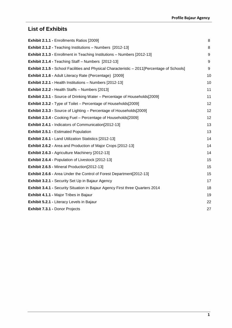
List of Exhibits
Exhibit 2.1.1 - Enrollments Ratios [2009] 8
Exhibit 2.1.2 - Teaching Institutions – Numbers [2012-13] 8
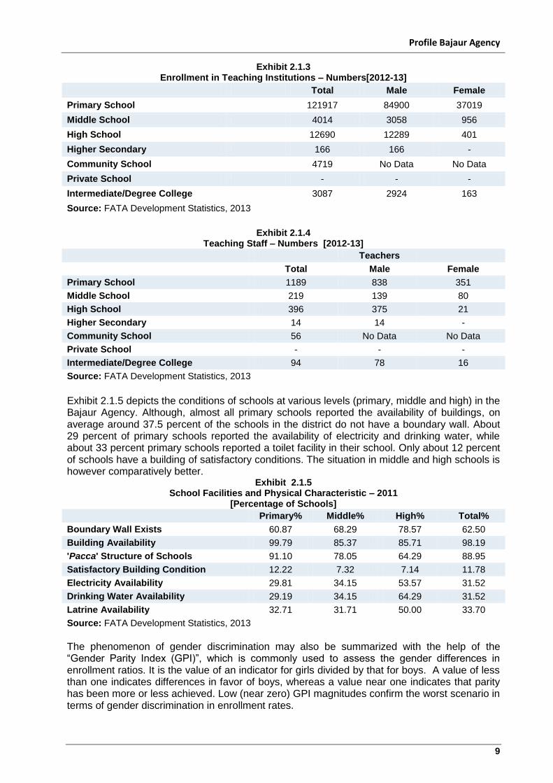
Exhibit 2.1.3 - Enrollment in Teaching Institutions – Numbers [2012-13] 9
Exhibit 2.1.4 - Teaching Staff – Numbers [2012-13] 9
Exhibit 2.1.5 - School Facilities and Physical Characteristic – 2011[Percentage of Schools] 9
Exhibit 2.1.6 - Adult Literacy Rate (Percentage) [2009] 10
Exhibit 2.2.1 - Health Institutions – Numbers [2012-13] 10
Exhibit 2.2.2 - Health Staffs – Numbers [2013] 11
Exhibit 2.3.1 - Source of Drinking Water – Percentage of Households[2009] 11
Exhibit 2.3.2 - Type of Toilet – Percentage of Households[2009] 12
Exhibit 2.3.3 - Source of Lighting – Percentage of Households[2009] 12
Exhibit 2.3.4 - Cooking Fuel – Percentage of Households[2009] 12
Exhibit 2.4.1 - Indicators of Communication[2012-13] 13
Exhibit 2.5.1 - Estimated Population 13
Exhibit 2.6.1 - Land Utilization Statistics [2012-13] 14
Exhibit 2.6.2 - Area and Production of Major Crops [2012-13] 14
Exhibit 2.6.3 - Agriculture Machinery [2012-13] 14
Exhibit 2.6.4 - Population of Livestock [2012-13] 15
Exhibit 2.6.5 - Mineral Production[2012-13] 15
Exhibit 2.6.6 - Area Under the Control of Forest Department[2012-13] 15
Exhibit 3.2.1 - Security Set Up in Bajaur Agency 17
Exhibit 3.4.1 - Security Situation in Bajaur Agency First three Quarters 2014 18
Exhibit 4.1.1 - Major Tribes in Bajaur 19
Exhibit 5.2.1 - Literacy Levels in Bajaur 22
Exhibit 7.3.1 - Donor Projects 27
Profile Bajaur Agency
2
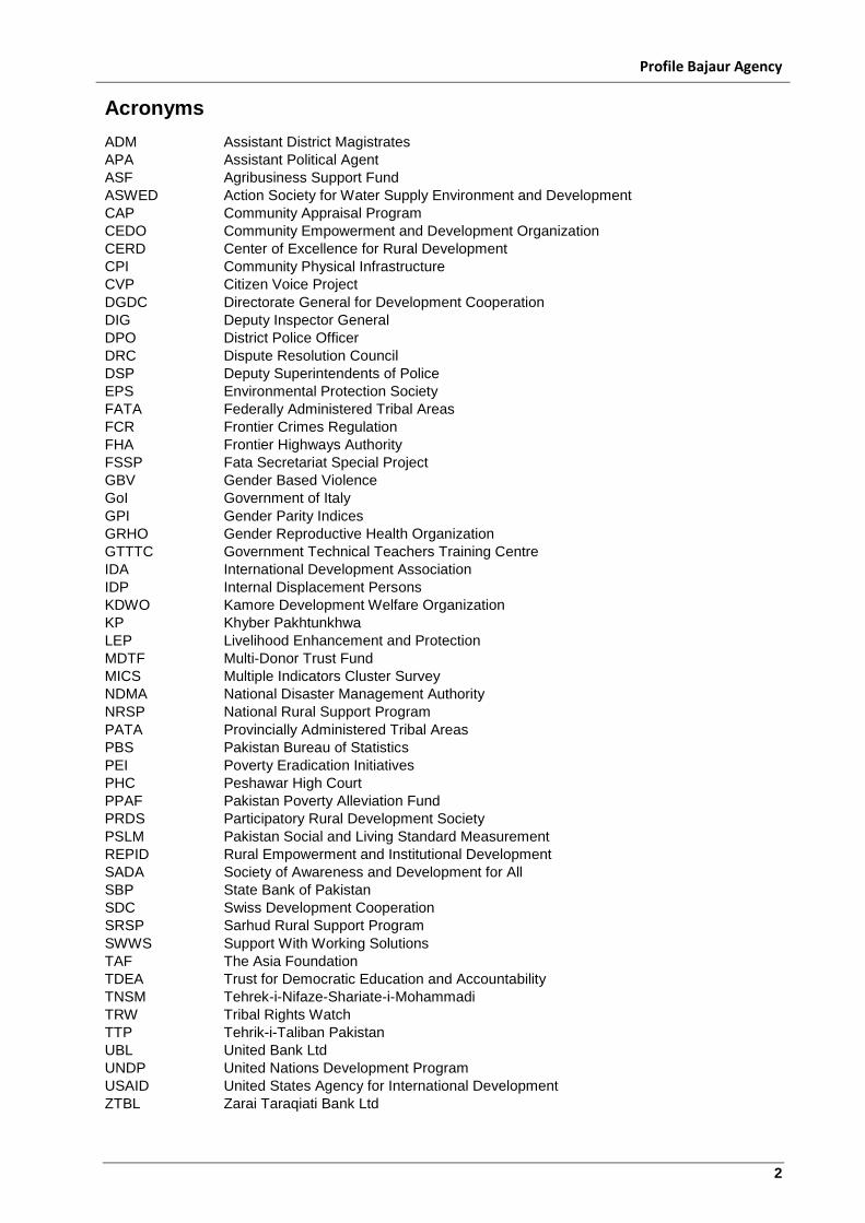
Acronyms
ADM Assistant District Magistrates
APA Assistant Political Agent
ASF Agribusiness Support Fund
ASWED Action Society for Water Supply Environment and Development
CAP Community Appraisal Program
CEDO Community Empowerment and Development Organization
CERD Center of Excellence for Rural Development
CPI Community Physical Infrastructure
CVP Citizen Voice Project
DGDC Directorate General for Development Cooperation
DIG Deputy Inspector General
DPO District Police Officer
DRC Dispute Resolution Council
DSP Deputy Superintendents of Police
EPS Environmental Protection Society
FATA Federally Administered Tribal Areas
FCR Frontier Crimes Regulation
FHA Frontier Highways Authority
FSSP Fata Secretariat Special Project
GBV Gender Based Violence
GoI Government of Italy
GPI Gender Parity Indices
GRHO Gender Reproductive Health Organization
GTTTC Government Technical Teachers Training Centre
IDA International Development Association
IDP Internal Displacement Persons
KDWO Kamore Development Welfare Organization
KP Khyber Pakhtunkhwa
LEP Livelihood Enhancement and Protection
MDTF Multi-Donor Trust Fund
MICS Multiple Indicators Cluster Survey
NDMA National Disaster Management Authority
NRSP National Rural Support Program
PATA Provincially Administered Tribal Areas
PBS Pakistan Bureau of Statistics
PEI Poverty Eradication Initiatives
PHC Peshawar High Court
PPAF Pakistan Poverty Alleviation Fund
PRDS Participatory Rural Development Society
PSLM Pakistan Social and Living Standard Measurement
REPID Rural Empowerment and Institutional Development
SADA Society of Awareness and Development for All
SBP State Bank of Pakistan
SDC Swiss Development Cooperation
SRSP Sarhud Rural Support Program
SWWS Support With Working Solutions
TAF The Asia Foundation
TDEA Trust for Democratic Education and Accountability
TNSM Tehrek-i-Nifaze-Shariate-i-Mohammadi
TRW Tribal Rights Watch
TTP Tehrik-i-Taliban Pakistan
UBL United Bank Ltd
UNDP United Nations Development Program
USAID United States Agency for International Development
ZTBL Zarai Taraqiati Bank Ltd
Profile Bajaur Agency
3
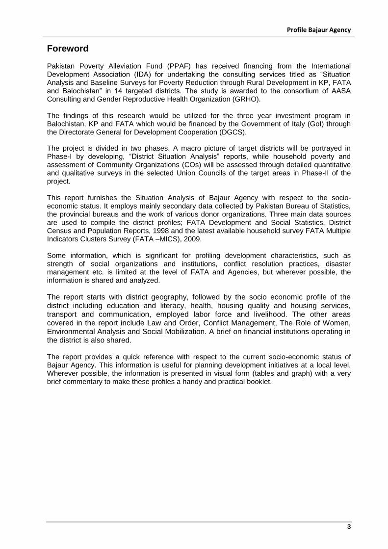
Foreword Pakistan Poverty Alleviation Fund (PPAF) has received financing from the International Development Association (IDA) for undertaking the consulting services titled as “Situation Analysis and Baseline Surveys for Poverty Reduction through Rural Development in KP, FATA and Balochistan” in 14 targeted districts. The study is awarded to the consortium of AASA Consulting and Gender Reproductive Health Organization (GRHO). The findings of this research would be utilized for the three year investment program in Balochistan, KP and FATA which would be financed by the Government of Italy (GoI) through the Directorate General for Development Cooperation (DGCS).
The project is divided in two phases. A macro picture of target districts will be portrayed in Phase-I by developing, “District Situation Analysis” reports, while household poverty and assessment of Community Organizations (COs) will be assessed through detailed quantitative and qualitative surveys in the selected Union Councils of the target areas in Phase-II of the project. This report furnishes the Situation Analysis of Bajaur Agency with respect to the socio-economic status. It employs mainly secondary data collected by Pakistan Bureau of Statistics, the provincial bureaus and the work of various donor organizations. Three main data sources are used to compile the district profiles; FATA Development and Social Statistics, District Census and Population Reports, 1998 and the latest available household survey FATA Multiple Indicators Clusters Survey (FATA –MICS), 2009. Some information, which is significant for profiling development characteristics, such as strength of social organizations and institutions, conflict resolution practices, disaster management etc. is limited at the level of FATA and Agencies, but wherever possible, the information is shared and analyzed.
The report starts with district geography, followed by the socio economic profile of the district including education and literacy, health, housing quality and housing services, transport and communication, employed labor force and livelihood. The other areas covered in the report include Law and Order, Conflict Management, The Role of Women, Environmental Analysis and Social Mobilization. A brief on financial institutions operating in the district is also shared. The report provides a quick reference with respect to the current socio-economic status of Bajaur Agency. This information is useful for planning development initiatives at a local level. Wherever possible, the information is presented in visual form (tables and graph) with a very brief commentary to make these profiles a handy and practical booklet.
Profile Bajaur Agency
4
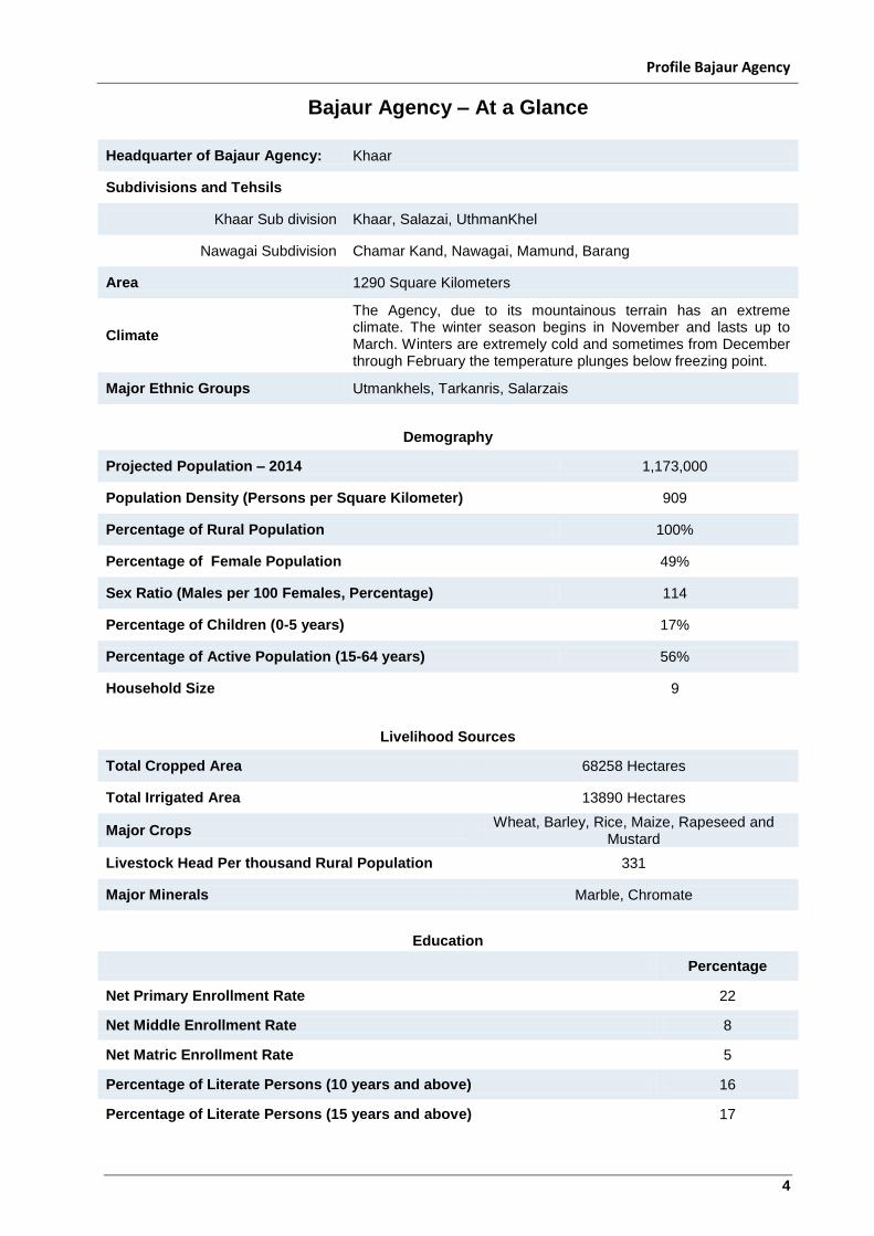
Bajaur Agency – At a Glance
Headquarter of Bajaur Agency: Khaar
Subdivisions and Tehsils
Khaar Sub division Khaar, Salazai, UthmanKhel
Nawagai Subdivision Chamar Kand, Nawagai, Mamund, Barang
Area 1290 Square Kilometers
Climate
The Agency, due to its mountainous terrain has an extreme climate. The winter season begins in November and lasts up to March. Winters are extremely cold and sometimes from December through February the temperature plunges below freezing point.
Major Ethnic Groups Utmankhels, Tarkanris, Salarzais
Demography
Projected Population – 2014 1,173,000
Population Density (Persons per Square Kilometer) 909
Percentage of Rural Population 100%
Percentage of Female Population 49%
Sex Ratio (Males per 100 Females, Percentage) 114
Percentage of Children (0-5 years) 17%
Percentage of Active Population (15-64 years) 56%
Household Size 9
Livelihood Sources
Total Cropped Area 68258 Hectares
Total Irrigated Area 13890 Hectares
Major Crops Wheat, Barley, Rice, Maize, Rapeseed and
Mustard
Livestock Head Per thousand Rural Population 331
Major Minerals Marble, Chromate
Education
Percentage
Net Primary Enrollment Rate 22
Net Middle Enrollment Rate 8
Net Matric Enrollment Rate 5
Percentage of Literate Persons (10 years and above) 16
Percentage of Literate Persons (15 years and above) 17
Profile Bajaur Agency
5
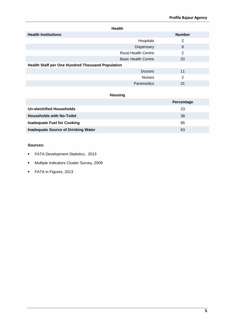
Health
Health Institutions Number
Hospitals 2
Dispensary 8
Rural Health Centre 2
Basic Health Centre 20
Health Staff per One Hundred Thousand Population
Doctors 11
Nurses 2
Paramedics 31
Housing
Percentage
Un-electrified Households 23
Households with No-Toilet 38
Inadequate Fuel for Cooking 85
Inadequate Source of Drinking Water 63
Sources: FATA Development Statistics, 2013 Multiple Indicators Cluster Survey, 2009 FATA in Figures, 2013
Profile Bajaur Agency
6
1.0 About Bajaur
1.1 Location and Boundary
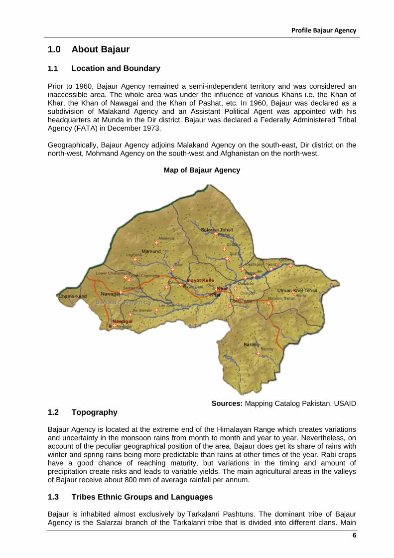
Prior to 1960, Bajaur Agency remained a semi-independent territory and was considered an inaccessible area. The whole area was under the influence of various Khans i.e. the Khan of Khar, the Khan of Nawagai and the Khan of Pashat, etc. In 1960, Bajaur was declared as a subdivision of Malakand Agency and an Assistant Political Agent was appointed with his headquarters at Munda in the Dir district. Bajaur was declared a Federally Administered Tribal Agency (FATA) in December 1973. Geographically, Bajaur Agency adjoins Malakand Agency on the south-east, Dir district on the north-west, Mohmand Agency on the south-west and Afghanistan on the north-west.
Map of Bajaur Agency
Sources: Mapping Catalog Pakistan, USAID
1.2 Topography Bajaur Agency is located at the extreme end of the Himalayan Range which creates variations and uncertainty in the monsoon rains from month to month and year to year. Nevertheless, on account of the peculiar geographical position of the area, Bajaur does get its share of rains with winter and spring rains being more predictable than rains at other times of the year. Rabi crops have a good chance of reaching maturity, but variations in the timing and amount of precipitation create risks and leads to variable yields. The main agricultural areas in the valleys of Bajaur receive about 800 mm of average rainfall per annum.
1.3 Tribes Ethnic Groups and Languages Bajaur is inhabited almost exclusively by Tarkalanri Pashtuns. The dominant tribe of Bajaur Agency is the Salarzai branch of the Tarkalanri tribe that is divided into different clans. Main
Profile Bajaur Agency
7
sub-tribes include; Utmankhel, Tarkalanri, Mamund (Kakazai, Wur and Salarzai) as well as a small population of Safis. The Utmankhelis are in the south-east of Bajaur, while Mamund are in the south-west, and the Tarkalanriare in the North of Bajaur. Its border with Afghanistan's Kunar province makes it of strategic importance to Pakistan and the region. Bajaur Agency is divided into Seven Tehsils, which are Barang, Nawagai, Khar, Mamund, Salarzai, Utmankhel and Chamarkand. Most of the land in Khar, Bajaur, Raghagan, Lossum, Pashat and Babukara areas still belongs to Khans. Bajaur today is different from the past when the whole tribe acknowledged allegiance to one ruling family of whom Safdar Khan, the Khan of Nawagai is the lineal descendant. Owing to the dissension in the tribe, the power of the former ruling chief has in the course of time diminished.
1.4 Climate The Agency, due to its mountainous terrain has an extreme climate. The winter season begins in November and lasts in March. Winters are extremely cold and sometimes from December through February the temperature plunges below freezing point. Bajaur is located at the extreme end of the Himalayan Range, which creates variation and uncertainty in the monsoon rains. Nevertheless, on account of the peculiar geographical position of the area, Bajaur does get its share of rain, with winter and spring rainfall being more predictable than rainfall at other times of the year. The main agricultural areas in the valleys of Bajaur receive about 800 mm of average rainfall per annum.
Profile Bajaur Agency
8
2.0 Socio-Economic Profile of the District
2.1 Education and Literacy
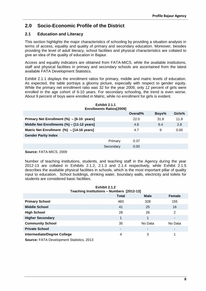
This section highlights the major characteristics of schooling by providing a situation analysis in terms of access, equality and quality of primary and secondary education. Moreover, besides providing the level of adult literacy, school facilities and physical characteristics are collated to give an idea of the quality of education in Bajaur.
Access and equality indicators are obtained from FATA-MICS, while the available institutions, staff and physical facilities in primary and secondary schools are ascertained from the latest available FATA Development Statistics.
Exhibit 2.1.1 displays the enrollment ratios for primary, middle and matric levels of education. As expected, the table portrays a gloomy picture, especially with respect to gender equity. While the primary net enrollment ratio was 32 for the year 2009, only 12 percent of girls were enrolled in the age cohort of 6-10 years. For secondary schooling, the trend is even worse. About 9 percent of boys were enrolled in Matric, while no enrollment for girls is evident.
Exhibit 2.1.1 Enrollments Ratios[2009]
Overall% Boys% Girls%
Primary Net Enrollment (%) – [6-10 years] 22.0 31.8 11.8
Middle Net Enrollments (%) – [11-12 years] 4.8 6.4 2.8
Matric Net Enrollment (%) – [14-16 years] 4.7 9 0.00
Gender Parity Index
Primary 0.37
Secondary 0.00
Source: FATA-MICS, 2009
Number of teaching institutions, students, and teaching staff in the Agency during the year 2012-13 are collated in Exhibits 2.1.2, 2.1.3 and 2.1.4 respectively, while Exhibit 2.1.5 describes the available physical facilities in schools, which is the most important pillar of quality input to education. School buildings, drinking water, boundary walls, electricity and toilets for students are considered basic facilities.
Exhibit 2.1.2 Teaching Institutions – Numbers [2012-13]
Total Male Female
Primary School 483 328 155
Middle School 41 25 16
High School 28 26 2
Higher Secondary 1 1 -
Community School 35 No Data No Data
Private School - - -
Intermediate/Degree College 4 3 1
Source: FATA Development Statistics, 2013
Profile Bajaur Agency
9
Exhibit 2.1.3 Enrollment in Teaching Institutions – Numbers[2012-13]
Total Male Female
Primary School 121917 84900 37019
Middle School 4014 3058 956
High School 12690 12289 401
Higher Secondary 166 166 -
Community School 4719 No Data No Data
Private School - - -
Intermediate/Degree College 3087 2924 163
Source: FATA Development Statistics, 2013
Exhibit 2.1.4
Teaching Staff – Numbers [2012-13]
Teachers
Total Male Female
Primary School 1189 838 351
Middle School 219 139 80
High School 396 375 21
Higher Secondary 14 14 -
Community School 56 No Data No Data
Private School - - -
Intermediate/Degree College 94 78 16
Source: FATA Development Statistics, 2013
Exhibit 2.1.5 depicts the conditions of schools at various levels (primary, middle and high) in the Bajaur Agency. Although, almost all primary schools reported the availability of buildings, on average around 37.5 percent of the schools in the district do not have a boundary wall. About 29 percent of primary schools reported the availability of electricity and drinking water, while about 33 percent primary schools reported a toilet facility in their school. Only about 12 percent of schools have a building of satisfactory conditions. The situation in middle and high schools is however comparatively better.
Exhibit 2.1.5 School Facilities and Physical Characteristic – 2011
[Percentage of Schools]
Primary% Middle% High% Total%
Boundary Wall Exists 60.87 68.29 78.57 62.50
Building Availability 99.79 85.37 85.71 98.19
'Pacca' Structure of Schools 91.10 78.05 64.29 88.95
Satisfactory Building Condition 12.22 7.32 7.14 11.78
Electricity Availability 29.81 34.15 53.57 31.52
Drinking Water Availability 29.19 34.15 64.29 31.52
Latrine Availability 32.71 31.71 50.00 33.70
Source: FATA Development Statistics, 2013
The phenomenon of gender discrimination may also be summarized with the help of the “Gender Parity Index (GPI)”, which is commonly used to assess the gender differences in enrollment ratios. It is the value of an indicator for girls divided by that for boys. A value of less than one indicates differences in favor of boys, whereas a value near one indicates that parity has been more or less achieved. Low (near zero) GPI magnitudes confirm the worst scenario in terms of gender discrimination in enrollment rates.
Profile Bajaur Agency
10
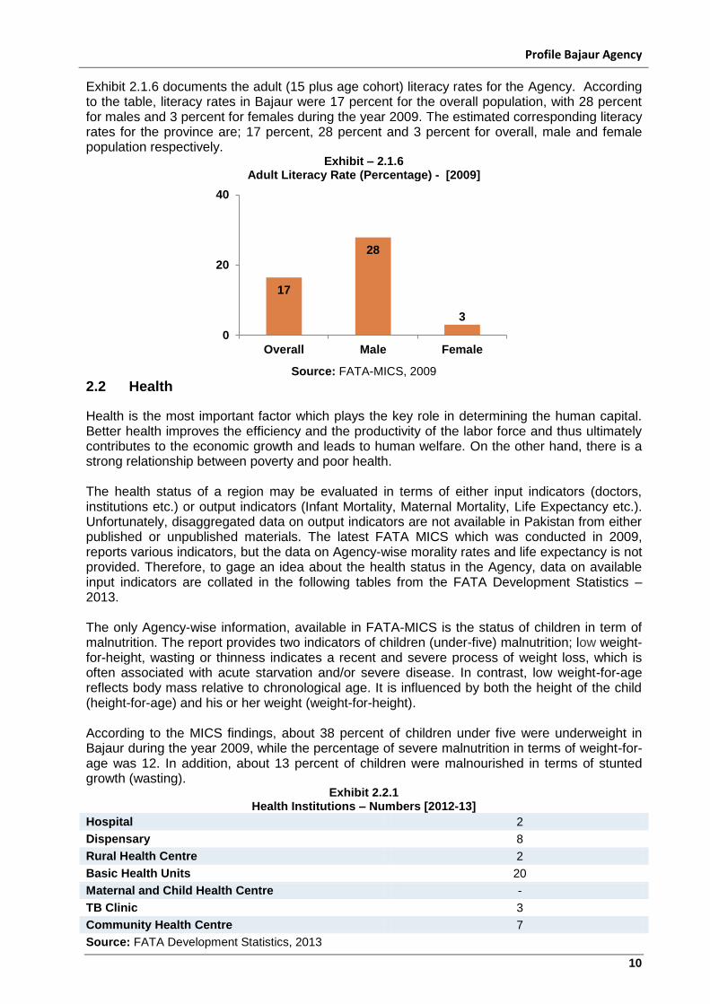
Exhibit 2.1.6 documents the adult (15 plus age cohort) literacy rates for the Agency. According to the table, literacy rates in Bajaur were 17 percent for the overall population, with 28 percent for males and 3 percent for females during the year 2009. The estimated corresponding literacy rates for the province are; 17 percent, 28 percent and 3 percent for overall, male and female population respectively.
Exhibit – 2.1.6 Adult Literacy Rate (Percentage) - [2009]
Source: FATA-MICS, 2009
2.2 Health
Health is the most important factor which plays the key role in determining the human capital. Better health improves the efficiency and the productivity of the labor force and thus ultimately contributes to the economic growth and leads to human welfare. On the other hand, there is a strong relationship between poverty and poor health. The health status of a region may be evaluated in terms of either input indicators (doctors, institutions etc.) or output indicators (Infant Mortality, Maternal Mortality, Life Expectancy etc.). Unfortunately, disaggregated data on output indicators are not available in Pakistan from either published or unpublished materials. The latest FATA MICS which was conducted in 2009, reports various indicators, but the data on Agency-wise morality rates and life expectancy is not provided. Therefore, to gage an idea about the health status in the Agency, data on available input indicators are collated in the following tables from the FATA Development Statistics – 2013. The only Agency-wise information, available in FATA-MICS is the status of children in term of malnutrition. The report provides two indicators of children (under-five) malnutrition; low weight-for-height, wasting or thinness indicates a recent and severe process of weight loss, which is often associated with acute starvation and/or severe disease. In contrast, low weight-for-age reflects body mass relative to chronological age. It is influenced by both the height of the child (height-for-age) and his or her weight (weight-for-height). According to the MICS findings, about 38 percent of children under five were underweight in Bajaur during the year 2009, while the percentage of severe malnutrition in terms of weight-for-age was 12. In addition, about 13 percent of children were malnourished in terms of stunted growth (wasting).
Exhibit 2.2.1 Health Institutions – Numbers [2012-13]
Hospital 2
Dispensary 8
Rural Health Centre 2
Basic Health Units 20
Maternal and Child Health Centre -
TB Clinic 3
Community Health Centre 7
Source: FATA Development Statistics, 2013
17
28
3
0
20
40
Overall Male Female
Profile Bajaur Agency
11
Numbers of health institutions in the Agency during the year 2012-13 are collated in Exhibit 2.2.1, while strength of health staff is furnished in Exhibit 2.2.2. A gloomy picture is evident in terms of the strength of the Bajaur Agency in providing health facilities. Only 11 doctors and 2 nurses are available for every one hundred thousand (0.1 million) people, according to the statistics provided by the FATA official publications.
Exhibit 2.2.2
Health Staffs – Numbers [2013]
Total
Per One Hundred Thousand population
Doctors 134 11
Nurses 20 2
Paramedics 366 31
Source: FATA Development Statistics, 2013
2.3 Housing Quality and Housing Services It is of interest to assess the means and standard of living directly provided by the government and those that are acquired by the household. Shelter is one of the basic needs, and housing conditions are one of the key determinants of the quality of life. To observe the access to housing facilities, three indicators are used Vis a Vis, proportion of households using electricity, cooking gas, and tap water. The quality of housing stock is generally evaluated in terms of material used in the wall and roof and the type of toilet in the house. However, data is available only for the type of toilet facility. Although the last (1998) population and housing census data is available for these variables of housing quality and housing services, it is however preferred to use FATA MICS (2009) data for these indicators. The provision of safe drinking water is an important part of planning for the healthy population. Exhibit 2.3.1 displays sources of drinking water in Bajaur. According to the MICS estimates, about 63 percent of households fetch water from unsafe or unimproved sources (unprotected water reservoirs). About 15 percent of households reported the tap water facilities, while the percentage of households which fetch water from a protected well or spring is about 20 percent.
Exhibit 2.3.1
Source of Drinking Water – Percentage of Households [2009]
Percentage
Tap Water 14.8
Hand Pump 2.5
Protected Well/Spring 19.8
Other (Uncovered) 63.1
Source: FATA-MICS, 2009
Information regarding the type of toilet used by household is furnished in Exhibit 2.3.2. A huge chunk (38 percent) of households reported the unavailability of toilet facilities in the house. Moreover, the table also reveals that the bulk (59 percent) of households reported the non-flush toilet system in -house, while about 3 percent of households reported the use of flush toilets.
Profile Bajaur Agency
12
Exhibit 2.3.2 Type of Toilet – Percentage of Households
[2009]
Percentage
Flush 2.7
Non-Flush 59.0
No Toilet 38.3
Source: FATA-MICS, 2009
The Exhibit 2.3.3 reveals that about 77 percent of households in the agency were connected with the grid and use electricity for lighting purposes during the year 2009. The rest of the households use Kerosene Oil, candles and other materials for lighting.
Exhibit 2.3.3
Source of Lighting – Percentage of Households [2009]
Percentage
Electricity 77.3
Oil and Other Material 22.7
Source: FATA-MICS, 2009
Exhibit 2.3.4 provides information regarding the sources of cooking fuel. Wood and charcoal are the main sources of cooking fuel according to the table. About 85 percent of households use firewood for cooking. The percentage of households who reported the use of gas (PPG) for cooking purposes is about one percent.
Exhibit 2.3.4
Cooking Fuel – Percentage of Households [2009]
Percentage
Fire Wood/Charcoal 84.8
Dung Cake 8.6
Straw Wheat 3.2
Grasses 1.6
Gas – LPG 1.4
Source: FATA-MICS, 2009
2.4 Transport and Communication Roads, transportation and telecommunication networks have a significant impact on socialization and modernization. Two indicators have been considered to portray the level of development of the transport and communication sector; road mileage per 100 square kilometers of geographical area, and the number of telephones per one hundred thousand persons. These indicators, depicted in Exhibit 2.4.1 are estimated from the latest published data of the FATA Development Statistics - 2013. However, data on availability of public and private transport and vehicles and internet connections is not available. The exhibit reveals that about 270 persons out of one lakh (one hundred thousand) population were connected with PTCL landlines during the year 2012-13. The data on broadband connections in the Agency is not available. About 418 and 179 kilometers mettled (black topped) and Shingle road is available out of one thousand kilometer of geographical area respectively.
Profile Bajaur Agency
13
Exhibit 2.4.1 Indicators of Communication
[2012-13]
Numbers Per one Hundred Thousand
Population
Number of Connections
Landline 3148 270
Broadband Data is not available
Road Kilometers Per ’000’
Square Kilometer
Black Topped 540 418
Shingle 232 179
Total 772 598
Source: FATA Development Statistics, 2013
2.5 Population and Employed Labor Force The characteristics of the employed force are important to understand the economic structure and potential of any region. However, limited data is available in terms of distribution of labor force into sectors, occupational groups and working status. MICS which was conducted in FATA area during 2009 provides very little information regarding labor force and employment. According to the Exhibit 2.5.1, the estimated current population of the Bajaur Agency is about 12 lakh (1.173 million) with an average growth rate of 4.24 percent per annum. These population projections are taken from “FATA Development Statistics-2013” which applies inter-census (1981-1988) growth rate for the population projection. Although population growth rate seems high, in the absence of any reliable reference, this growth rate is used for the projection.
Exhibit 2.5.1 Estimated Population
Rural
1998 – Census 595,000
2010 – Projected 990,000
2014 – Projected 1,173,000
Growth Rate [1998-2014] 4.24%
Source: FATA Development Statistics, 2013
About 0.43 million persons are projected as the active labor force for the year 2014 by applying the crude activity rate of KP. According to MICS (2009), the percentage of the employed population in the Agency was 43.8 percent, out of which about half the employed persons (48.6 percent) are working in other provinces in Pakistan. A significant percentage (12 percent) of employed persons is also reported as working outside the country.
2.6 Livelihood Sources
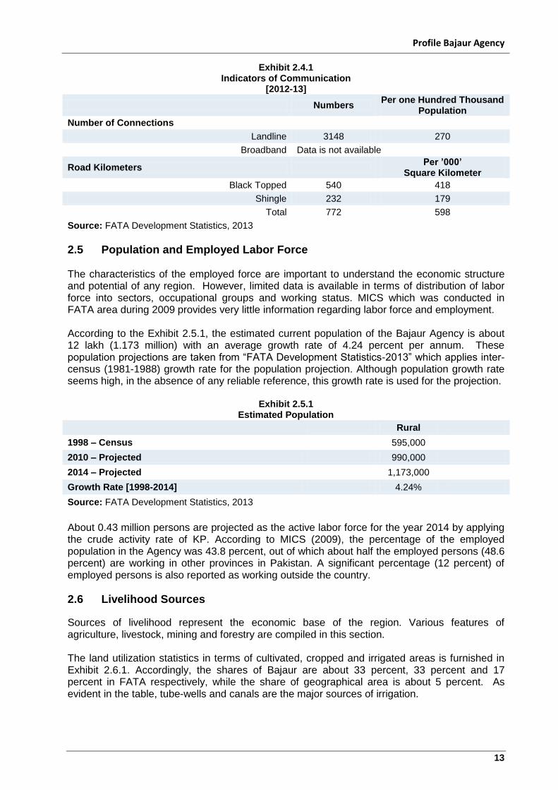
Sources of livelihood represent the economic base of the region. Various features of agriculture, livestock, mining and forestry are compiled in this section. The land utilization statistics in terms of cultivated, cropped and irrigated areas is furnished in Exhibit 2.6.1. Accordingly, the shares of Bajaur are about 33 percent, 33 percent and 17 percent in FATA respectively, while the share of geographical area is about 5 percent. As evident in the table, tube-wells and canals are the major sources of irrigation.
Profile Bajaur Agency
14
Exhibit 2.6.1 Land Utilization Statistics [2012-13]
(Hectares)
As percent of FATA
Geographical Area 129,035 4.7
Cultivated Area 75,480 33.2
Cropped Area 68,258 33.2
Irrigated Area 13,890 17.2
Sources of Irrigation
Canal 3,330
Wells 1,520
Tube Wells 6,800
Tanks 120
Lift Pump 120
Others 2,000
Source: FATA Development Statistics, 2013
Major crops in Bajaur Agency are shown in the Exhibit 2.6.2. With the largest share in the cropped area, wheat is sown on 33920 hectares. This is followed by barley (10074 hectares). Rice, rapeseed and mustard, maize, and vegetable alsohave significant shares in the cropped areas and are sown on more than 1000 hectares.
Exhibit 2.6.2
Area and Production of Major Crops [2012-13]
Area
[Hectares] Production
[Tons]
Crops
Wheat 33,920 27,941
Barley 10,075 8,207
Rice 4,710 7,000
Maize 3,695 4,990
Rape Seed and Mustard 3,121 960
Rabbi Vegetables 1,176 10,988
Onion 450 5,878
Turnip 428 6,012
Kharif Fruits 423 4,119
Spinach 378 2,500
Kharif Vegetables 270 1,379
Cauliflower 240 1,489
Tomatoes 178 1,137
Plum 135 1,274
Note: Those crops are included which are sown more on than 100 hectares.
Source: FATA Development Statistics, 2013
The numbers and share of agricultural machinery as a proportion of cropped area reflect the extent of modernization of agriculture. Only tractors are reported in the agriculture machinery. According to Exhibit 2.6.3, about 5 tractors are available per one thousand cropped area.
Exhibit 2.6.3
Agriculture Machinery [2012-13]
Numbers As percent of ‘000’ cropped
area
Tractors 312 4.6
Source: FATA Development Statistics, 2013
Profile Bajaur Agency
15
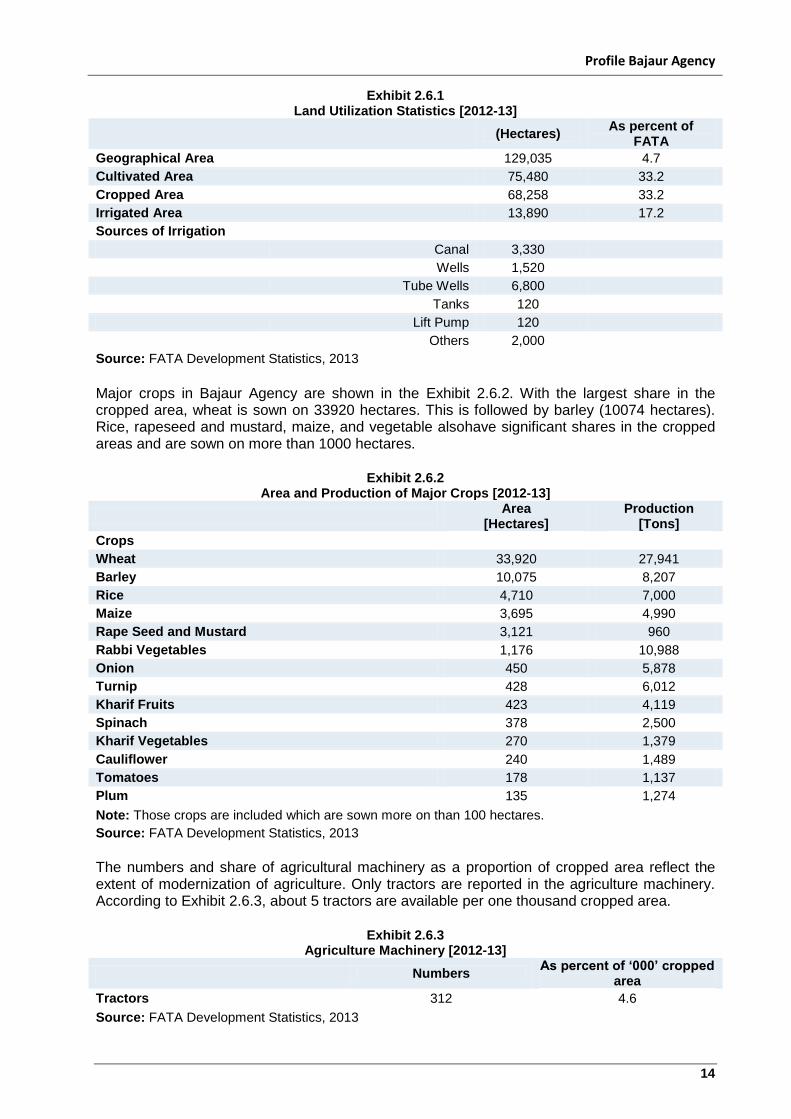
Livestock is also an important source of livelihood in rural areas. Exhibit 2.6.4 displays the availability of various livestock per one thousand rural households. The table reveals that Goats and Cattle are the major type of livestock in the Agency.
Exhibit 2.6.4
Population of Livestock [2012-13]
Numbers Per thousand Rural
Households
Cattle 132,000 1,023
Buffalo 15,000 116
Sheep 53,000 411
Goats 173,000 1,341
Camel 15,003 116
Source: FATA Development Statistics, 2013
In minerals, the production of marble and chromate are reported for the year 2012-13. Production of these minerals and also the share in FATA with respect to these types of minerals are furnished in Exhibit 2.6.5. The share of Bajaur in FATA is6 percent and 8 percent for marble and chromate respectively
Exhibit 2.6.5
Mineral Production [2012-13]
(Tons)
As percent of FATA
Marble 3,089 6.1
Chromate 2,773 8.0
Source: FATA Development Statistics, 2013
Exhibit 2.6.6 reports the area under the control of the Forest Department of FATA. The table reveals that the Agency has about 0.322 million acres of forest area which is about 5 percent of the FATA forest area.
Exhibit 2.6.6
Area Under the Control of Forest Department [2012-13]
(Acres)
As percent of FATA
Man Made Forest 65,186 16.5
Linear Plantation 82 1.7
Natural Forest 23,323 41.9
Forest Area Covered 88,571 9.3
Total 322,500 4.7
Source: FATA Development Statistics, 2013
Profile Bajaur Agency
16
3.0 Law and Order
3.1 Background Bajaur Agency is directly administered through the office of the Political Agent under the command of Governor of KP. Frontier Crimes Regulation is the legal statute giving immense executive and judicial powers to the Political Agent. The area is tribal in nature where all the tribes have collective responsibility for maintaining law and order on their respective lands1. There have been many crimes taking place especially in the wake of militancy and the rise of “Tehreek-e-Taliban Pakistan (TTP)”, Bajaur Chapter, under Mullah Faqeer Muhammad. This group have committed crimes against humanity and caused the loss of dozens of lives, injuries and the displacement of hundreds of thousands of people from Bajaur2. Cross border activity is the most common in Bajaur. Most of these activities are carried out by “Tehreek-e-Taliban Pakistan (TTP)”. Nuristan and Kunar are the most poorly governed areas in Afghanistan that provides these militants a sufficient place to reside and strategize. The government of Pakistan has continuously requested the Government of Afghanistan to clear these areas but there has been no effective response. The NATO forces in Afghanistan are over stretched and they lack the resources to clear militants from these areas. With various militant groups operating in the district of Bajaur, violence was on the rise in 2012. In the second quarter of 2012, there were 18 terrorist incidents including a military operation spread over two weeks eliminating 209 militants. In these 18 attacks there were around 368 casualties out of which, 302 were killed and 66 were injured. There was some collateral damage killing 35 civilians and injuring 25. In the third quarter of the same year, the violence was increased by 125 percent as compared to second quarter. The difference between the two quarters was that in third, Bajaur witnessed a cross border attack. The largest casualties incurred during the military operation. A surprise attack took place in Pakistan, executed by Afghan militants on 24th August, 2012. This attack resulted in border occupancy by the militants. The army however, managed to strike back; killing 29 Afghani Taliban members and forced hundreds of insurgents back across the border. The Government in Bajaur is being strengthened never the less, cross border activity remains the main concern responsible for security tension. Although militancy is the major concern in Bajaur Agency for the armed forces, there are certain other crimes that have become a cause of concern for the law enforcement agencies. Similar to the other districts, major crimes taking place in the Agency are also related to land disputes, financial disputes in the market place, and women and honor related issues.
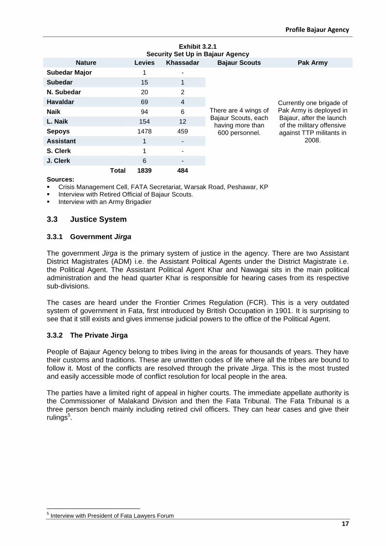
3.2 Law Enforcement Agencies The chief executive of Bajaur Agency is the Political Agent. He has all the executive and judicial powers. He has access to Bajaur Levies and Khassadar force to maintain law and order in the agency. Bajaur Scouts are the Para-military force existing in Bajaur to support the PA. They are a branch of the Frontier Corps and work under the command of Commandant Bajaur Scouts (a Colonel rank Army officer)3 Under the FRC rule in Fata, all the tribes are responsible for maintaining law and order in their respective areas. Therefore, in the wake of militancy since the rise of TTP, most of the tribes in Bajaur have formed their local tribal Militias (Lashkars)4.
1 Interview with Senior Socio Cultural Specialist, International Organization for Migration
2 Interview with a Political Activist and Views of the President of Fata Research Center, Islamabad
3 Interview with a Political Activist
4 Interview with Ex-President of a Political Party in the Agency
Profile Bajaur Agency
17
Exhibit 3.2.1 Security Set Up in Bajaur Agency
Nature Levies Khassadar Bajaur Scouts Pak Army
Subedar Major 1 -
There are 4 wings of Bajaur Scouts, each
having more than 600 personnel.
Currently one brigade of Pak Army is deployed in Bajaur, after the launch of the military offensive against TTP militants in
2008.
Subedar 15 1
N. Subedar 20 2
Havaldar 69 4
Naik 94 6
L. Naik 154 12
Sepoys 1478 459
Assistant 1 -
S. Clerk 1 -
J. Clerk 6 -
Total 1839 484
Sources: Crisis Management Cell, FATA Secretariat, Warsak Road, Peshawar, KP Interview with Retired Official of Bajaur Scouts. Interview with an Army Brigadier
3.3 Justice System 3.3.1 Government Jirga The government Jirga is the primary system of justice in the agency. There are two Assistant District Magistrates (ADM) i.e. the Assistant Political Agents under the District Magistrate i.e. the Political Agent. The Assistant Political Agent Khar and Nawagai sits in the main political administration and the head quarter Khar is responsible for hearing cases from its respective sub-divisions. The cases are heard under the Frontier Crimes Regulation (FCR). This is a very outdated system of government in Fata, first introduced by British Occupation in 1901. It is surprising to see that it still exists and gives immense judicial powers to the office of the Political Agent. 3.3.2 The Private Jirga People of Bajaur Agency belong to tribes living in the areas for thousands of years. They have their customs and traditions. These are unwritten codes of life where all the tribes are bound to follow it. Most of the conflicts are resolved through the private Jirga. This is the most trusted and easily accessible mode of conflict resolution for local people in the area. The parties have a limited right of appeal in higher courts. The immediate appellate authority is the Commissioner of Malakand Division and then the Fata Tribunal. The Fata Tribunal is a three person bench mainly including retired civil officers. They can hear cases and give their rulings5.
5 Interview with President of Fata Lawyers Forum
Profile Bajaur Agency
18
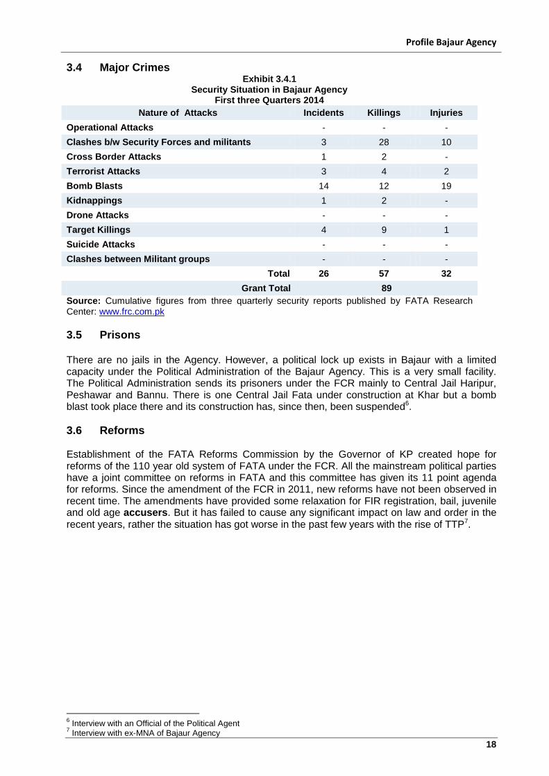
3.4 Major Crimes Exhibit 3.4.1
Security Situation in Bajaur Agency First three Quarters 2014
Nature of Attacks Incidents Killings Injuries
Operational Attacks - - -
Clashes b/w Security Forces and militants 3 28 10
Cross Border Attacks 1 2 -
Terrorist Attacks 3 4 2
Bomb Blasts 14 12 19
Kidnappings 1 2 -
Drone Attacks - - -
Target Killings 4 9 1
Suicide Attacks - - -
Clashes between Militant groups - - -
Total 26 57 32
Grant Total 89
Source: Cumulative figures from three quarterly security reports published by FATA Research Center: www.frc.com.pk
3.5 Prisons There are no jails in the Agency. However, a political lock up exists in Bajaur with a limited capacity under the Political Administration of the Bajaur Agency. This is a very small facility. The Political Administration sends its prisoners under the FCR mainly to Central Jail Haripur, Peshawar and Bannu. There is one Central Jail Fata under construction at Khar but a bomb blast took place there and its construction has, since then, been suspended6.
3.6 Reforms Establishment of the FATA Reforms Commission by the Governor of KP created hope for reforms of the 110 year old system of FATA under the FCR. All the mainstream political parties have a joint committee on reforms in FATA and this committee has given its 11 point agenda for reforms. Since the amendment of the FCR in 2011, new reforms have not been observed in recent time. The amendments have provided some relaxation for FIR registration, bail, juvenile and old age accusers. But it has failed to cause any significant impact on law and order in the recent years, rather the situation has got worse in the past few years with the rise of TTP7.
6 Interview with an Official of the Political Agent
7 Interview with ex-MNA of Bajaur Agency
Profile Bajaur Agency
19
4.0 Conflict Management Bajaur Agency is the most populated agency among seven FATA agencies. People of Bajaur mainly come from two major tribes i.e. Tarkani and Utmankhel. This is a tribal area governed directly by the Governor KP under Frontier Crimes Regulation 1901, amended 2011. People of Bajaur like, other nearby areas, face the menace of extremism, militancy and subsequent military operations since the US invasion of Afghanistan October 2002.
a) Militancy is the Major Conflict: “Tehreek-e-Taliban Pakistan (TTP)” has been operational in Bajaur since it emergence and challenged the writ of the government. TTP had occupied most of the area bordering Afghanistan in the near past targeting government officials, tribal elders and general people. Hundreds of people were killed in suicide attacks, IED blasts and direct fights with armed forces8.
b) Other Disputes: other disputes in Bajaur Agency mainly include those of lands, tribal enmities, personal enmities, honor issues, financial issues at market level and other small criminal nature issues.
There is no patwar (revenue) system in Bajaur. Land is not properly registered and demarcated. Mostly family have create land disputes regarding land distribution amongst themselves. However, there are disputed lands among tribes, as well, in which big pieces of lands are sitting idle and therefore don’t yield any crops9.
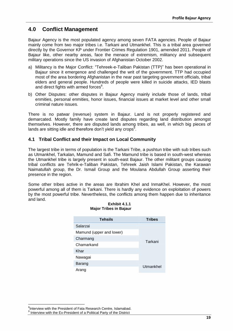
4.1 Tribal Conflict and their Impact on Local Community The largest tribe in terms of population is the Tarkani Tribe, a pushtun tribe with sub tribes such as Utmankhel, Tarkalan, Mamund and Safi. The Mamund tribe is based in south-west whereas the Utmankhel tribe is largely present in south-east Bajaur. The other militant groups causing tribal conflicts are Tehrik-e-Taliban Pakistan, Tehreek Jaish Islami Pakistan, the Karawan Naimatullah group, the Dr. Ismail Group and the Moulana Abdullah Group asserting their presence in the region. Some other tribes active in the areas are Ibrahim Khel and InmaKhel. However, the most powerful among all of them is Tarkani. There is hardly any evidence on exploitation of powers by the most powerful tribe. Nevertheless, the conflicts among them happen due to inheritance and land.
Exhibit 4.1.1 Major Tribes in Bajaur
Tehsils Tribes
Salarzai
Tarkani
Mamund (upper and lower)
Charmang
Chamarkand
Khar
Nawagai
Barang Utmankhel
Arang
8Interview with the President of Fata Research Centre, Islamabad.
9 Interview with the Ex-President of a Political Party of the District
Profile Bajaur Agency
20
4.2 Local Dispute Resolution Mechanism The above mentioned conflicts are resolved in the local judiciary system i.e. Jirga. In terms of awareness of human rights, the local women are not very well acquainted with theirs. One plausible argument is lack of education. They are not even allowed to visit the local courts or villages due to cultural constraints.
4.3 Conflict Resolution System Government Jirga is the main system of conflict resolution in Bajaur Agency. It is legal and is backed up by the Government. In Bajaur Agency, the Assistant Political Agent (APA) has powers to designate a Jirga. This Jirga will comprise of six members. Four members will be nominated by the APA while each party will nominate their respective representative to this Jirga. The Jirga hears the case in detail and then comes up with a suggested decision. The APA has authority to accept this decision or dissolve the Jirga and constitute another Jirga to hear the case. They normally decide matters under the Tribal Codes of respective tribal areas i.e. under the Riwaj of Tarkani tribes and that of the Utmankhel tribe. The system ruling decisions of Utmankhel tribe is called code of Atta Baba10. The parties have a limited right of appeal in higher courts. The immediate appellate authority is the Commissioner Malakand Division and then the Fata Tribunal. The Fata Tribunal is a three person bench, mainly including retired civil officers. They can hear cases and give their rulings. The article 247 of the constitution of Pakistan denies the higher courts jurisdiction to Fata. Recently the Peshawar High Court has observed that that lack of jurisdiction of higher courts in Fata is against the basic rights and also causes law and order issues in Fata and adjacent KP districts and agencies11. The Private Jirga: Local people also refer their issues to the Jirga system outside the Political Agents (PAs) office. The tribal people as in other areas of Pakistan nominate elders or a council of elders. They give proper ear to the problem under consideration and decide on the basis of an established code of tribal traditions and customs. This system varies in different tribes but people mostly understand their own system12. The Shariat: is also one of the main sources of conflict resolution. The area is very religious. People believe in religious scholars and admire the Ulema. The Ulema also sit in conflict resolution and they give decisions on the basis of what Islamic Law or Shariat says13.
4.4 Displacement
During the military operation in Bajaur in 2008, most of the people living in Afghanistan’s bordering tehsils, belonging mostly to Tarkani tribe were displaced to the nearby districts. They preferred taking refuge in the camps established in the areas that had their host families at safer places. Bajaur operation of 2008 created the largest pool of IDPs in the history of Pakistan with 550,000 IDPs from the Agency14. They are now mostly settled back in their areas, however, some 400 families still reside in Jalozai IDP camps in district Nowshehra. They cannot return because of some problem regarding their land they had been living in, prior to being displaced. During the military operation, severe fighting took place between militants and the armed forces. This resulted in
10
Interview with a Jirga Representative and Religious Scholar 11
Constitution of Pakistan, Article 247 12
Interview with a Political Activist and Ex-Mayor, Bajaur 13
Interview with Jirga r Representative and Religious Scholar, Bajaur 14
Crisis of IDPs in Fata , Issues, Challenges and way Forward: Fata Research Center, January, 2014
Profile Bajaur Agency
21
heavy losses to property, houses and market places. Some of villages have been dashed to the ground like those of Loi-Sum, Rasahakai, Janat Sha, Tangkhata, Nisarabad and others of the Khar Tehsil. Markets of Li-sum and Inayat Kalay were destroyed. These losses have led to large-scale misery and the poverty ratio has risen sharply as well. Most people living in these villages have lost their shops, cattle, crops and other sources of income while there were plenty who had to leave Bajaur in search of income to other districts15.
4.5 Issues of Internally Displaced People (IDPs) and their Impact on Host Economies
The biggest issues for the IDPs is among females who in their daily life are already victims of other form of violence such as, domestic, social, physical and mental abuse. The militancy has worsened the situation for these women. Most of the violence statistics are low, particularly because they are not reported due to cultural binding. Grave challenges arise for the Pashtun women in the IDPs camps. These women, who are restricted and socially inexperienced, have to stand in ration queues and interact with men for the purpose of shelter, food, clothing, and medical facilities.
15
Interview with a Local Political Activist
Profile Bajaur Agency
22
5.0 The Role of Women In Bajaur, while the overall literacy rate is low, it is particularly low for women, which means that they lack access to education16. Also due to the restriction of purdah, many women are stuck at home and are unable to work or study. Bajaur is mainly an agricultural district; however, it seems that only men are capable and allowed to work on the farms. This further restricts women because it gives them no financial autonomy at all. A study conducted shows that women from these areas tend to suffer more from mental and physical disabilities; the data shows that 6.6 percent of women are effected in comparison to only 2.2 percent of men. The report also shows that women tend to suffer from depression and anxiety disorders due to their circumstances. Lack of facilities and medical help further aggravates their oppression17. There are many more issues that affect women; however, until political instability is resolved, the entire community will suffer. In particular, the issues of women will be left behind.
5.1 Status of Women Women in Bajaur are oppressed and have no rights, due to the restriction of the veil (purdah), many women are stuck at home and are unable to work or study. Bajaur is mainly an agricultural district; however, it seems that only men are capable and allowed to work on the farms. This further restricts women because it gives them no financial autonomy at all. Due to the military operation in Bajaur, most of the people were compelled to leave the area and reside in camps in other districts of KP18. Specially women and children were more vulnerable and faced the risks of abuse, exploitation, violence and discrimination not only during the conflict but during their displacement, and return to their places of origin. During the conflict, mainly schools, colleges and hospitals were destroyed, leaving women and children with no access to basic services.
5.2 Literacy Level The literacy rate of Bajaur Agency is 171 percent, in which the male literacy rate is 28 2 percent and the female literacy rate is 3 percent19. Hundreds of educational institutions were affected by militancy, while the lack of basic facilities is also creating obstacles in the development and progress of the education sector. According to the 1981 Census, Khar tehsil had the highest literacy rate of 5.84 percent whereas Charmang tehsil had the lowest of 2.52 percent20.
Exhibit 5.2.1 Literacy Levels in Bajaur
Number of Primary Schools 483
Number of middle Schools 41
Number of High Schools 28
Female Primary Participation Rate 12 %
Male Primary participation Rate 32 %
Male Middle Participation Rate 6 %
Male Middle Participation Rate 3%
16
Community Appraisal & Motivation Program: The Inter-Agency Early Recovery Needs Assessment (IAERNA), pg 12 17
Community Appraisal & Motivation Program: The Inter-Agency Early Recovery Needs Assessment (IAERNA), pg 27 18
Building a Protective Environment for Conflict, Bajaur Agency, Hayat Foundation 19
FATA-MICS, 2009 20
Socio-Economic Profile of Bajaur Agency, Tribal Areas Development Project, USAID
Profile Bajaur Agency
23
5.3 Gender Ratio
The average household consists of 9 individuals in Bajaur Agency21. The male and female ratio is 114 males to 100 females. 22 percent of the male population is below 18 years while 29 percent of the female population is below 18 years, indicating a female dominated youth population.
5.4 Local Conflicts and Judiciary System Local conflicts are resolved in the local judiciary system i.e. Jirga. In terms of awareness of human and women’s rights, the local women are not aware and the only plausible argument for it is lack of education. They are not even allowed to visit the local courts or villages due to cultural constraints.
5.5 Violence against Women Females in their daily life are already victims of other form of violence such as, domestic, social, physical and mental abuse22. The militancy has worsened the situation for these women. Most of the violence statistics are low particularly because they are not reported due to cultural binding. Even victimized women are not provided shelter, food, clothing, and medical facilities.
21
FATA-MICS (2009) 22
Development Profile of Bajaur, op. cit.
Profile Bajaur Agency
24
6.0 Environmental Analysis In 1960, Bajaur was declared as a subdivision of Malakand Agency and divided into seven tehsils, which are Barang, Nawagai, Khar, Mamund, Salarzai, Utmankhel and Chamarkand. Bajaur remained a semi-independent territory and was considered as an inaccessible area under the Political jurisdiction of the Political Agent, Malakand. The whole area was under the influence of various Khans i.e. the Khan of Khar, the Khan of Nawagai and the Khan of Pashat, etc. Bajaur was declared a Federally Administered Tribal Agency in December 1973. 23 Bajaur Agency shares 52 km long border with Afghanistan’s Kunar province in the north-west. The Bajaur and Mohmand hills of this northern region can be considered as a transition zone24. The total area of the Agency is 1,290 sq km.
6.1 Climate Land and Water Bajaur Agency is located at the extreme end of the Himalayan Range which creates variations and uncertainty in the monsoon rains. Due to its mountainous terrain, the climate in the agency is of extreme nature; the winter season begins in November and lasts up to March. Winters are extremely cold and sometimes from December till February the temperature plunges below freezing point. Its terrain is mountainous to sub-mountainous and climate is semi-arid to arid having both winter and summer seasons. Mean winter temperature ranges from 5 to 10˚C, whereas mean summer temperature varies from 23 to 36˚C25. The terrain of the agency is hilly, rugged, barren, and mostly arid. The hills in the agency have been more or less completely denuded due to the dry climate of the area and excessive deforestation. Roughly, 40 percent of Bajaur is covered by barren mountains and the remaining 60 percent by wide valleys. The valley area is mostly broad, open and used as agricultural land. The major River Rud, actually a mountain stream, passes through Khar and Nawagai valleys26. Nearly 23.6 percent of the area is plain while 76.4 percent is mountainous27. Water availability is from surface and ground water in Bajaur Agency. Sources of surface water are rivers Natalai River, Jandool River, and Panjkora River. Panjkora River emerges from the mountain between Dir District and Afghanistan and flows into Swat River near Chakdara. Other large streams of Bajaur Agency are Babakara, Mullah Syed Watalai, Chaharmang, Khato, Bajaur, Arang, Barang, Dandmar and Jandool feeding the Swat River. Internally generated rainwater was estimated as 494 million cubic meter in the Bajaur Agency. Runoff is largely from Rocky Mountains. A runoff coefficient of 50 percent was used for the estimation of runoff due to steep slopes, poor vegetation and climatic stations largely located in the valley having less rainfall than high mountains. Internally generated surface water is 247 million cubic meter per annum. Mountain precipitation is not measured, which is considerably higher than that of the valley. Domestic water supply schemes are small in size and isolated. If designed and constructed properly can be managed effectively by the Water Users’ Associations. Most of the water supply schemes are based on the abstraction of groundwater from closed wells and tube wells. The distribution network is established and managed by the PHED. Some of the schemes have community collection points and water users collect water from these points28.
23
FATA-Rural Livelihood and Community Infrastructure Project (RLCIP) Supporting the Recovery and Livelihood Needs of the Targeted Communities of Bajaur, Mohmand and South Waziristan Agencies, Bajuar Agency, http://www.rlcipfata.gov.pk/Bajaur_agency_profile.php 24
Federally Administered Tribal Areas(FATA), Bajaur Agency, http://fata.gov.pk/Global-fac.php?iId=294&fid=26&pId=277&mId=107 25
Pakistan FATA Capacity Building Program, ibid. 26
Federally Administered Tribal Areas (FATA), Bajaur Agency, op. cit. 27
Pakistan FATA Capacity Building Program, op. cit. 28
Pakistan FATA Capacity Building Program, op. cit.
Profile Bajaur Agency
25
6.2 Forests, Fisheries and Agriculture The total area under forest is 88,571 acres.29 In the Bajaur Agency there is a potential for developing forestry and the area under natural forest is 23,323 acres. In the recent study, 16 fish species were recorded in Bajaur Agency. In 2010, 11species were recorded but now they are not found. Fish culture could easily be promoted in this poverty stricken area for enhancing economic activity which may in turn improve the earnings and life quality of the people of this area30. The total cultivated area of the agency is 75,480 hectares, while the uncultivated area is 53,685 hectares. Land under irrigation is around 13,890 hectares and un-irrigated area is over 54,000 hectares.31 Cultivable area is 0.086 million hectares and only 0.020 million hectares are irrigated, representing 23 percent of cultivable or 27 percent of cultivated area. Three-fourths of the cultivated area is under Barani and Spate irrigation and managed by farmers. In the Bajaur Agency there is a potential for developing agriculture, however most of the agriculture is dependent on groundwater.32 There are two distinct seasons in Bajaur, Rabi and Kharif, and Wheat, Barley, Maize, Rice, Rapeseed and Mustard are the main crops grown in the agency33.
6.3 Environmental Hazards Floods: The slope of Bajaur Agency moves from West to East with the mountains sloping towards the Bajaur Agency, therefore, all the runoff from precipitation is drained by the tributaries of the Bajaur34. The flood is of lesser duration and more highly intensive due to the excessive slopes. The banks of the River Khawar nearly washed the entire Khar city and the Mutakao area of Bajaur Agency during the monsoon floods. Major floods occur during the winter and summer monsoons. Due to the excessive sloping of the beds from West to East, the storm runoff in periods of flood erodes the banks35. The River Khawar, which at its starting point is only a few feet wide, has been widened several hundred feet in the middle portion due to the erosion of cultivated land. Therefore, precious cultivable land along the banks of the Khawar is wasted every year, because the river banks are not protected.
Rainfall: Bajaur is located at the extreme end of the Himalayan Range which creates variation and uncertainty in the monsoon rains from year to year36. Due to the geographical position, rain fall occurs in winter and spring sessions, meaning Rabi crops have a good chance of reaching maturity, but variations in the timing and amount of precipitation creates risks and leads to variable yields. Bajaur receive about 600 mm of rainfall per annum.
29
Federally Administered Tribal Areas (FATA), Bajaur Agency, http://fata.gov.pk/Global-fac.php?iId=294&fid=26&pId=277&mId=107, FATA Development Statistics 2013 30
Comparative Abundance of Fish Fauna of Different Streams of Bajaur Agency, Khyber Pakhtunkhwa, Pakistan, by Zaigham Hasan, , Wisal Khan, , Muneer Ahmad Khan, Latif-Ur-Rehman, Jehangir Khan, & Sana Ullah, http://www.academia.edu/8115373/Comparative_Abundance_of_Fish_Fauna_of_Different_Streams_of_Bajaur_Agency_Khyber_Pakhtunkhwa_Pakistan 31
Federally Administered Tribal Areas (FATA), Bajaur, op. cit., FATA Development Statistics 2013 32
Pakistan FATA Capacity Building Program, op. cit. 33
Socio- economic Profile of Bajaur Agency, by TSPU, TADP, RDD, United States Agency for International Development, 1991, http://pdf.usaid.gov/pdf_docs/PNABU840.pdf 34
Socio Economic profile of Bajaur Agency, Tribal Areas Development Project, USAID 35
ibid 36 ibid
Profile Bajaur Agency
26
There are two distinct seasons in Bajaur Agency:
Rabi or winter season: In this season there is about 290 mm of rainfall from December to April.
Kharif or monsoon season: In this season there is about 230 mm of rainfall from July to September.
In the remaining months, rainfall is usually light and unreliable however annual fluctuations occur widely
Profile Bajaur Agency
27
7.0 Social Mobilization
Numerous government and non-government programs and approaches have been used to promote rural development and poverty alleviation. Among these have been initiatives designed to build rural infrastructure, mobilize communities, enhance access to rural finance, and provide a social safety net.
7.1 Role of PPAF
PPAF has facilitated Poverty Eradication Initiatives (PEI) in completing a project in the health sector that is providing health care services to 4,130 community members. Mainly, PPAF has been providing support for two models namely: (a) Establishing community managed health centers, and (b) Strengthening government health centers, operating them for a period of up to 3 years and handing them back to the government. The objective of the PPAF health program has been to provide access to quality basic health services with special focus on maternal and child health to the poor and marginalized rural communities by focusing on all aspects required in this regard. These aspects include hiring of qualified and trained health care staff and paramedics, availability of proper buildings, standardized equipment, furniture and medicine and following WHO guidelines in terms of infection prevention practices.
7.2 Local NGOs NGOs working in the Agency included Community Empowerment and Development Organization (CEDO), Kamore Development Welfare Organization (KDWO), Dewah Organization, PAIMAN Alumni Trust, Participatory Rural Development Society (PRDS), Community Appraisal Program (CAP), Action Society for Water Supply Environment and Development (ASWED), Center of Excellence for Rural Development (CERD), Tribal Rights Watch (TRW) and Rural Empowerment and Institutional Development (REPID).37 The following NGOs are operating in the region:
Society of Awareness and Development for All (SADA)
Fata Secretariat Special Project (FSSP)
Sarhud Rural Support Program (SRSP)
National Rural Support Program (NRSP)
7.3 Focus of Donor Community In order to gain a better understanding of the programmatic focus of the various donor agencies operating in the area, the following table summarizes various projects operated in different sectors distinguished by donor and executing agencies in the district.
Exhibit 7.3.1 Donor Projects
Project Name Sector Donor Executing Agency
Agribusiness Project Agriculture USAID ASF
Strengthening Citizen Voice and Public Accountability Program
Democracy and Governance
USAID
Trust for Democratic Education and
Accountability (TDEA) and The Asia
Foundation (TAF) NGO Devolution Trust for
Community Empowerment
Economic Revitalization of KP
Multi-Donor Trust Fund (MDTF)
GOP KP
37
Humanitarian Information Management Portal, http://himpakistan.pk/AllOrganizations.aspx?region=fa
Profile Bajaur Agency
28
Exhibit 7.3.1 Donor Projects
Project Name Sector Donor Executing Agency
Governance Support Project
Governance Multi-Donor Trust
Fund (MDTF) GOP KP
FATA Urban Centers Project
World Bank GoP Pakistan
KP Emergency Roads Recovery
Disaster / Emergency
World Bank GoP Pakistan
FATA Urban Centers Project
The Netherlands TARUCCI, FATA
Secretariat.
FATA Emergency Rural Roads
Disaster / Emergency
The Netherlands Frontier Highways
Authority (FHA)
FATA Rural Livelihood and Community Infrastructure Project
Livelihood The Netherlands Directorate of Projects,
FATA Secretariat
Public Safety and Justice Program (PS&JP)
Governance / Security
The Netherlands DTCE
Advocacy for Effective Implementation of FCR Reforms in Bajaur Agency – A Sub Grant by Citizens’ Voice Project (CVP)
Democracy and Governance
USAID Citizen Voice Project
(CVP)
Livelihoods Program Hindukush Pakistan
Livelihood Swiss Development Cooperation (SDC)
Inter corporation, Govt of KP
FATA Development Program
Swiss Development Cooperation (SDC)
FATA Secretariat
KP/ FATA/ Balochistan Multi-Donor Trust Fund
Swiss Development Cooperation (SDC)
Profile Bajaur Agency
29
8.0 Important Institutions
8.1 Institutions and Stakeholders There are two administrative sub-divisions, Kharand and Nawagai. Each sub-division consists of three tehsils. Agency is administratively headed by a Political Agent and an Assistant Political Agent who is in charge of each sub-division- Bajaur Agency was established in 1973 with its headquarters at Khar38. The region is controlled by the Federal government of Pakistan, the federal authority in the context of the Federally Administered Tribal Areas. People of FATA are represented in the Parliament of Pakistan by their elected representatives both in National Assembly of Pakistan and the Senate of Pakistan. FATA has 12 members in the National Assembly and 8 members in the Senate. FATA has no representation in the Provincial Assembly of Khyber-Pakhtunkhwa.39 Stakeholders institutions are Water Users Associations and Farmers Organizations under the Water Users’ Association Act of 1982 and the Provincial Irrigation and Drainage Authorities Act of 1997 for the formerly NWFP, respectively. These institutions are almost non-existent in the Agencies and even if they exist are not effective.40
8.2 Financial Institutions in the Agency Bajaur is one of the most underdeveloped areas in Pakistan. Its economy is heavily reliant on agriculture. Main commercial banks that are operating in Bajaur Agency are National Bank of Pakistan, United Bank Ltd, Habib Bank Ltd and Allied Bank Ltd. These banks are primarily responsible for dealing with remittances that come from the relatives of local residents living abroad. Among the banks that deal with agricultural activities, Zarai Taraqiati Bank Limited (ZTBL) is the only bank operating in the district. However it is imperative to mention that State Bank of Pakistan (SBP) has launched agricultural schemes in Bajaur Agency in the past. The objective of the schemes was to revive the economic activities in the district that has been continuously in the midst of a war. The aforementioned commercial banks were the moderators of these schemes.
38
Socio- economic Profile of Bajaur Agency, ibid. 39
Federally Administered Tribal Areas http://en.wikipedia.org/wiki/Federally_Administered_Tribal_Areas 40
Pakistan FATA Capacity Building Program, Agency Development Plan 2010-Final Report, Water Sector Agency Development Plans – Bajaur And Mohmand Agencies , Main Report, prepared by DIA for review by United States Agency for International Development, October 2010, http://waterinfo.net.pk/sites/default/files/knowledge/Water%20Sector%20Agency%20Development%20Plans%20-%20Bajaur%20and%20Mohmand%20Agencies.pdf