SITE SUMMARY REPORT Hurley’s Dump NONCD 0000435 Montgomery ... · Hurley’s Dump NONCD 0000435...
73
SITE SUMMARY REPORT Hurley’s Dump NONCD 0000435 Montgomery County Senate Bill 1492 State of North Carolina State Contract N06009S Schnabel Project No. 06210002.23 February 23, 2010 Revised May 14, 2010 Prepared for: North Carolina Department of Environmental and Natural Resources Superfund Section Inactive Hazardous Sites Branch 401 Oberlin Road, Suite 150 Raleigh, NC 27605 Prepared by: Schnabel Engineering South, P.C. 11-A Oak Branch Drive Greensboro, North Carolina 27407 (336) 274-9456 Susan A. Mickiewicz Staff Scientist/Report Author Signature Gary Rogers, L.G. Senior Associate/Reviewer Signature
Transcript of SITE SUMMARY REPORT Hurley’s Dump NONCD 0000435 Montgomery ... · Hurley’s Dump NONCD 0000435...
SITE SUMMARY REPORT Hurley’s Dump
NONCD 0000435 Montgomery County
Senate Bill 1492
State of North Carolina State Contract N06009S
Schnabel Project No. 06210002.23
February 23, 2010 Revised May 14, 2010
Prepared for:
North Carolina Department of Environmental and Natural Resources Superfund Section
Inactive Hazardous Sites Branch 401 Oberlin Road, Suite 150
Raleigh, NC 27605
Prepared by:
Schnabel Engineering South, P.C.
11-A Oak Branch Drive Greensboro, North Carolina 27407
(336) 274-9456
Susan A. Mickiewicz Staff Scientist/Report Author Signature Gary Rogers, L.G. Senior Associate/Reviewer Signature

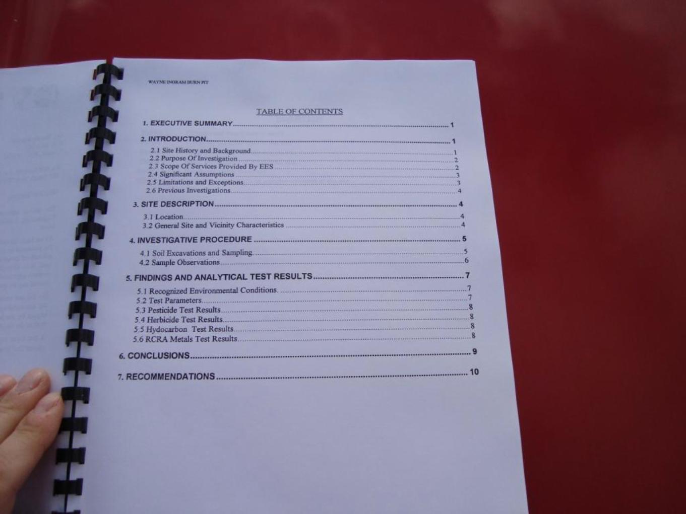
TABLE OF CONTENTS
Site Location Research Summary Areas of Note Site Summary
1.0 Site Conditions 1.1 On-site Structures 1.2 Current Site Usage 1.3 On-site Water Supply Wells and Intakes 1.4 Surface Water Features 1.5 Disposal Area 1.6 Disposal Area Conditions 1.7 Evidence of Human Activity 1.8 Potential Landfill Gas Migration Pathways 1.9 Physical Barriers 1.10 Other Pertinent Information
2.0 Vicinity Conditions
2.1 Structures Located on Adjacent Properties 2.2 Water Supply Wells and Intakes 2.3 Current Land Usage 2.4 Surface Water Features
3.0 Aerial Photography Review
TABLES Table 1 Tabulated GPS Coordinates
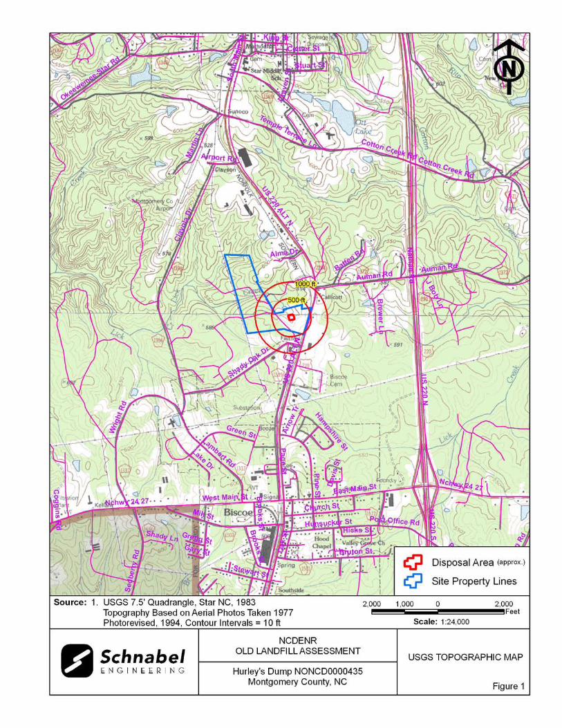
FIGURES Figure 1 USGS Topographic Map Figure 2 Site Map Figure 3 Vicinity Map Figure 4 Topographic Map Overlaid On LiDAR Shaded Relief Figure 5 LiDAR Shaded Relief
APPENDICES Appendix A Field Reconnaissance Sheet Appendix B Tax Records Appendix C Records of Communication\Site Visit Permission Letter Appendix D Site Photographs Appendix E Aerial Photographs Appendix F Supporting Documentation FILE: G:\2006_PROJECTS\06210002_(NCDENR_OLD_UNLINED_LANDFILL)\TASK_23_MONTGOMERY_CO\0435-HURLEY'SDUMP\REPORT\FINAL\NONCD0000435_HURLEY'SDUMP_SITESUMMARYREPORT_2010-05-14.DOC

Hurley’s Dump NONCD 0000435
1
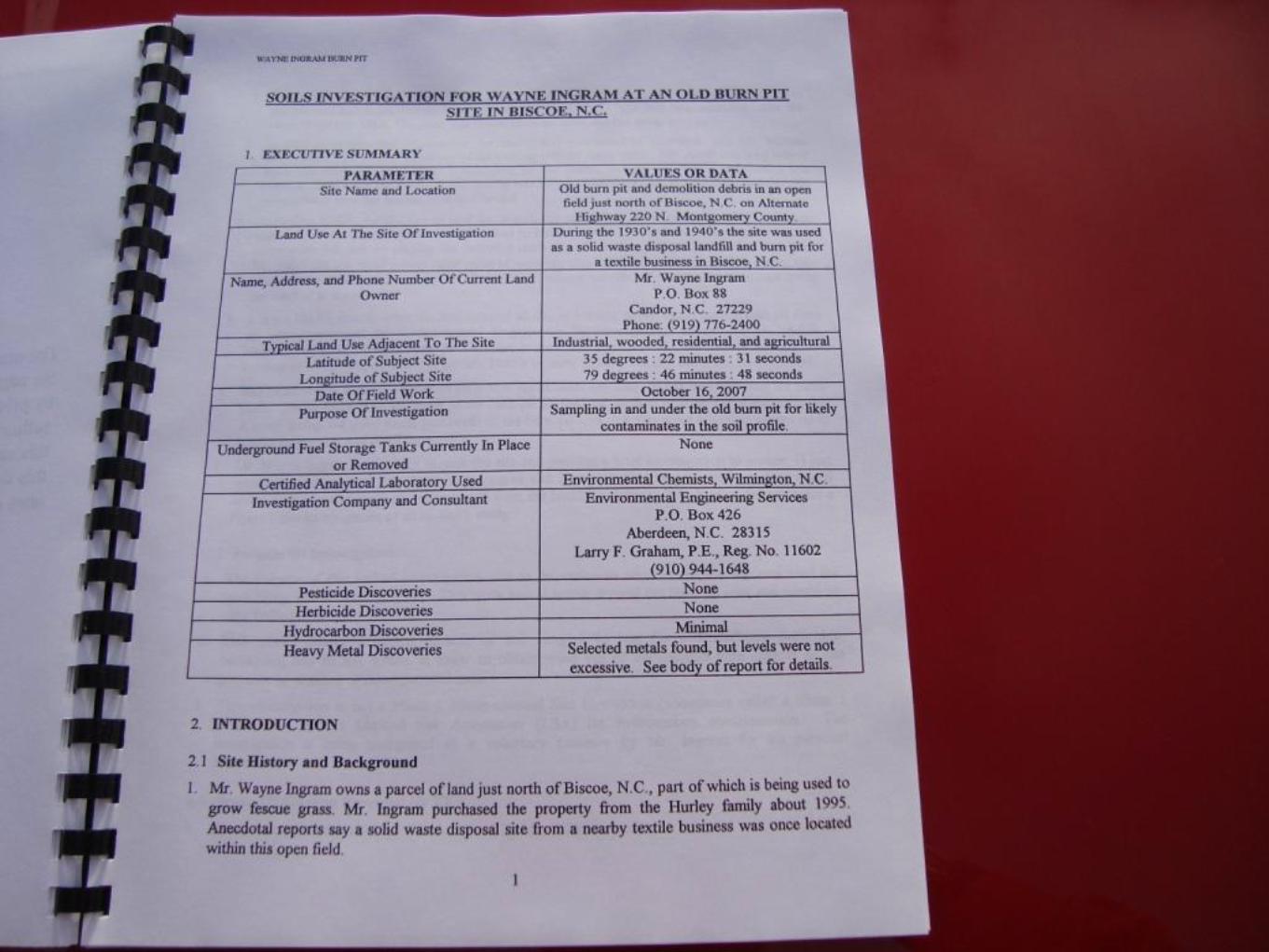
SITE LOCATION RESEARCH SUMMARY ID NUMBER: NONCD 0000435 SITE NAME(S): Hurley’s Dump LOCATION: US-220 Alt (North Main Street), Biscoe, NC 27209 COUNTY: Montgomery LANDFILL SIZE: 0.5 acres (Disposal Area perimeter identified from Environmental
Engineering Services (EES), 2007, and Mr. Wayne Ingram, property owner)
PROPERTY SIZE: 119.7 acres (from Montgomery County GIS) DATE OPENED: Approximately 1930’s (data obtained from EES, 2007) DATE CLOSED: Approximately late 1940’s to early 1950’s (data obtained from EES,
2007) CURRENT OWNER: Mr. Wayne Ingram CURRENT OWNER CONTACT: Property Owner CURRENT OWNER ADDRESS: P.O. Box 828, Biscoe, NC 27209 CURRENT OWNER TELEPHONE NUMBER: 910-428-9253 TAX PARCEL No./PIN No.: Parcel No. 7569-00-52-7436 DEED REFERENCE: Deed Book 249, Deed Page 439 COORDINATES: (assessed from GIS and EES, 2007) State Plane Coordinates (NAD83, meters): Northing: 180516 Easting: 538829. Latitude: N35o 22’ 29.2” Longitude: W79o 46’ 44.2”
Hurley’s Dump NONCD 0000435
2
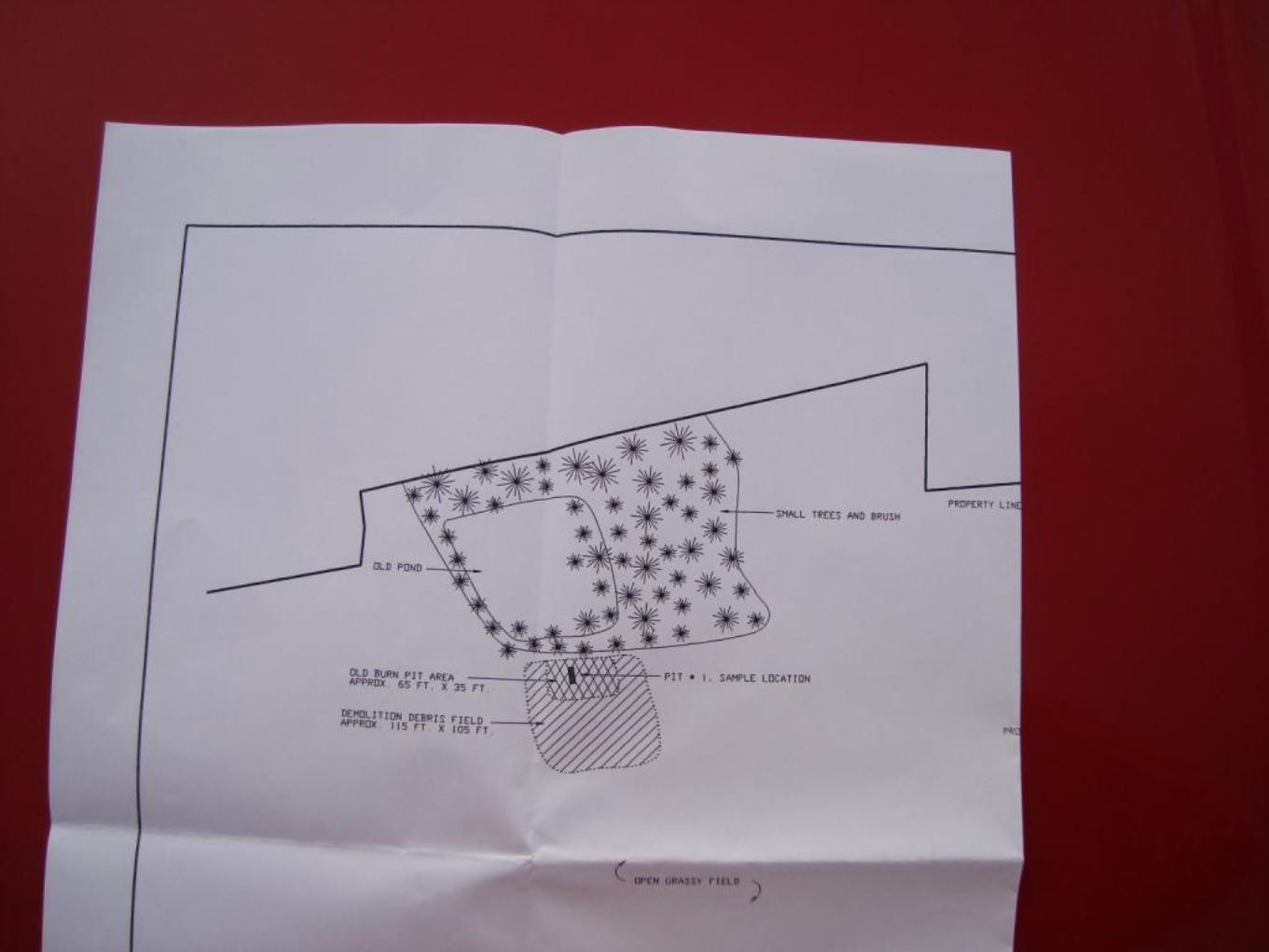
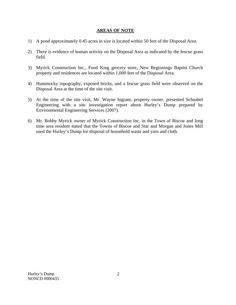
AREAS OF NOTE 1) A pond approximately 0.45 acres in size is located within 50 feet of the Disposal Area. 2) There is evidence of human activity on the Disposal Area as indicated by the fescue grass
field. 3) Myrick Construction Inc., Food King grocery store, New Beginnings Baptist Church
property and residences are located within 1,000 feet of the Disposal Area. 4) Hummocky topography, exposed bricks, and a fescue grass field were observed on the
Disposal Area at the time of the site visit. 5) At the time of the site visit, Mr. Wayne Ingram, property owner, presented Schnabel
Engineering with a site investigation report about Hurley’s Dump prepared by Environmental Engineering Services (2007).
6) Mr. Bobby Myrick owner of Myrick Construction Inc. in the Town of Biscoe and long
time area resident stated that the Towns of Biscoe and Star and Morgan and Jones Mill used the Hurley’s Dump for disposal of household waste and yarn and cloth.
Hurley’s Dump NONCD 0000435
3
SITE SUMMARY
1.0 SITE CONDITIONS
This section discusses the observed conditions on the Site, as defined as the property (Tax Parcel
7569-00-52-7436) on which the Disposal Area is located. The Disposal Area is defined as the
area observed or reported to have been used for waste placement or burial. The boundary
(perimeter) of this area is the observed limit based on Soils Investigation for Wayne Ingram at an
Old Burn Pit Site in Biscoe, NC report by Environmental Engineering Services (EES), 2007,
provided to Schnabel Engineering by Mr. Wayne Ingram, property owner (Appendix F). The site
visit was conducted on February 3, 2010. Photographs illustrating site conditions are included in
Appendix D.
The Site is located in Montgomery County, near Biscoe, NC. Driving directions to the Site from
the intersection of US 220 and NC Highway 24/27 are as follows:
1. Proceed west on NC Highway 24/27 (East Main Street) and drive approximately 0.7
miles.
2. Turn right onto US-220 Alt (North Main Street) and drive approximately 0.9 miles.
3. Turn left onto Shady Oak Drive and take an immediate right onto the gravel driveway
after the railroad tracks. The entrance to the Site is through the fescue grass field to the
north.
1.1 On-site Structures
No on-site buildings or other structures were observed during the site visit.
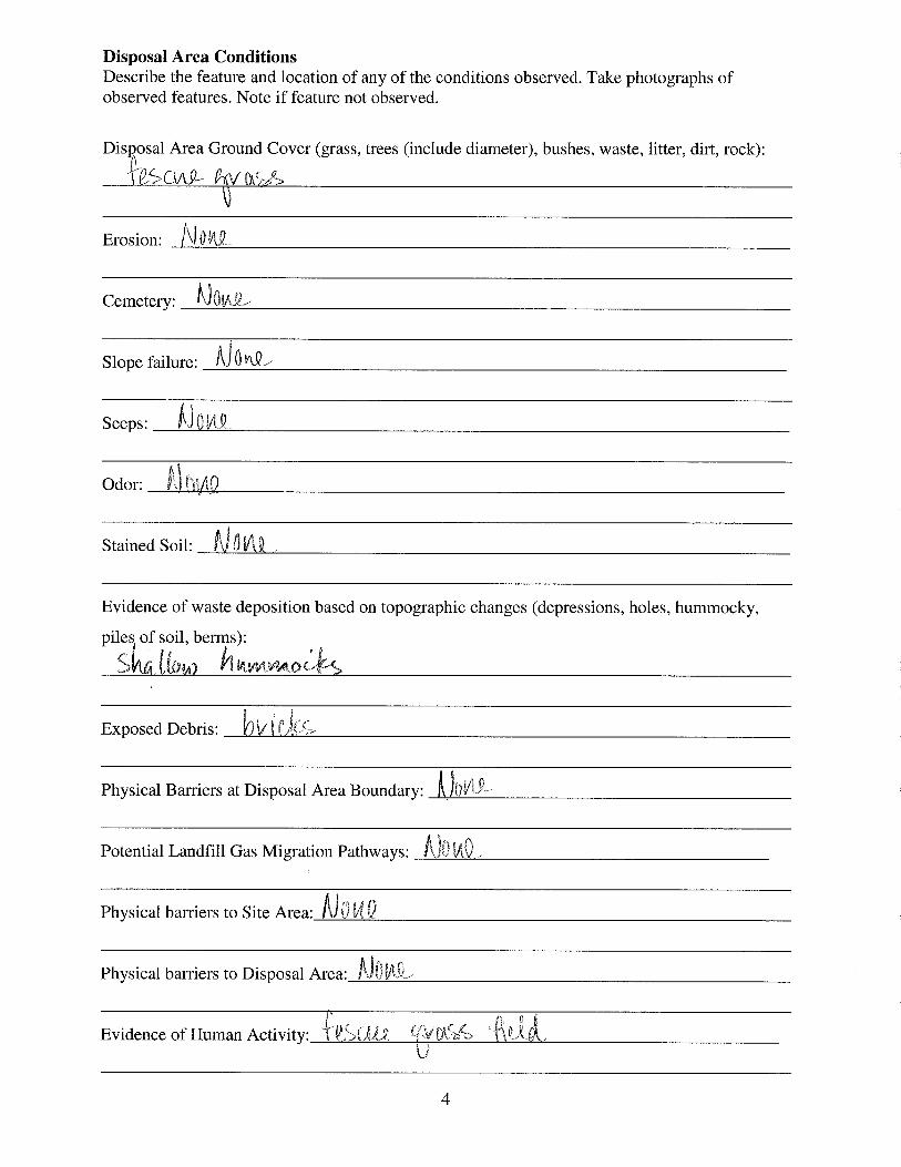
1.2 Current Site Usage
According to Mr. Wayne Ingram, property owner, the Site is used for growing fescue grass and
there are no future plans for development.

Hurley’s Dump NONCD 0000435
4
1.3 On-Site Water Supply Wells and Intakes
No on-site water supply wells were observed on the Site during the site visit. No water meters or
fire hydrants were observed on the Site during the site visit.
1.4 Surface Water Features
A pond approximately 0.45 acres in size is located within 50 feet of the Disposal Area. The
pond is surrounded by thick brush, briars, and pine trees and deciduous trees approximately two
inches to five inches in diameter.
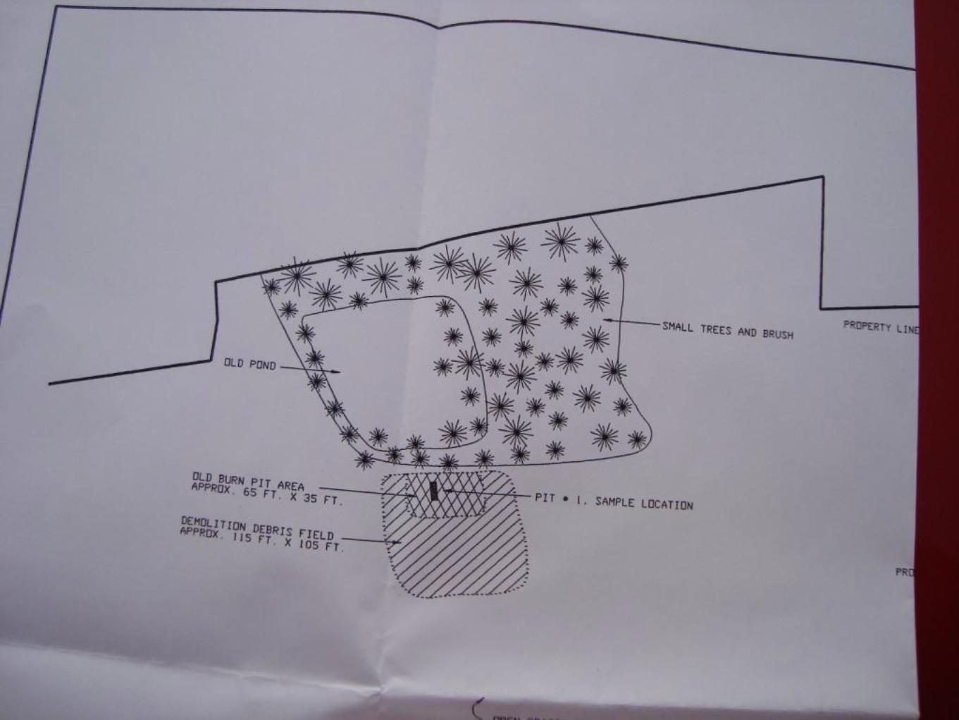
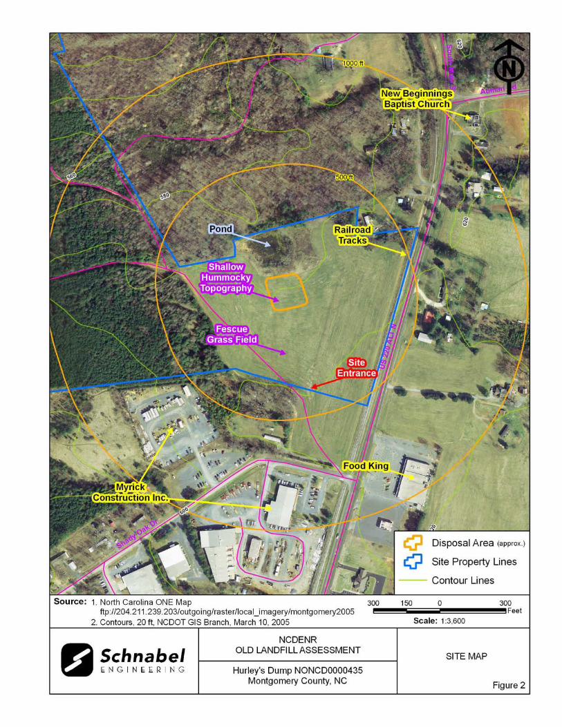
1.5 Disposal Area
Access to the Disposal Area is from a gravel driveway off of Shady Oak Drive and through the
fescue grass field (Photo 1). Mr. Wayne Ingram, property owner, accompanied Schnabel staff on
the Disposal Area visit. The Disposal Area occupies 0.5 acres based on the estimated Disposal
Area perimeter shown on Figures 1 through 3.
The ground surface of the Disposal Area slopes uniformly toward the north. A comparison was
made of the topography from the 1983 USGS 7.5 minute topographic quadrangle map (10 foot
contours, based on 1977) and the 2008 topographic map from NCDOT (4 foot contours).
Topographic lines in undisturbed or undeveloped areas of the two maps did not correlate well so
the maps could not be used to estimate the amount of fill or other topographic changes on the
Site.
The approximate Disposal Area perimeter is illustrated on the figures and on aerial photographs
in Appendix E. A table of GPS coordinates for the Site entrance and the Site perimeter is
presented in Table 1. The Disposal Area perimeter location is approximate and is based on the
Hurley’s Dump NONCD 0000435
5
reported findings from EES, 2007. Figures 4 and 5 show LiDAR shaded relief superimposed on
the Disposal Area.
1.6 Disposal Area Conditions
The Disposal Area was covered with fescue grass. Exposed bricks were observed on the
Disposal Area (Photo 4).
The observed Disposal Area was on Tax Parcel 7569-00-52-7436. The perimeter of the Disposal
Area was not visually evident at the time of the site visit.
Shallow hummocky topography was observed on the southern portion of the Disposal Area. No
notable erosion, depressions, offensive odors, stained or discolored soils, or slope failures were
observed during the site visit.
1.7 Evidence of Human Activity
Mr. Wayne Ingram, property owner, stated that fescue grass is grown on the Disposal Area.
1.8 Potential Landfill Gas Migration Pathways
There were no visible or evident potential gas migration pathways such as stormwater drain
systems, underground utilities, septic systems, or drain fields observed on the Disposal Area or
on the Site.
1.9 Physical Barriers
Site access is provided by a gravel driveway from Shady Oak Drive and then through the fescue
grass field.

Hurley’s Dump NONCD 0000435
6
1.10 Other Pertinent Information
Some history of the Site was obtained during conversations with persons familiar with the Site.
The information obtained indicates that:
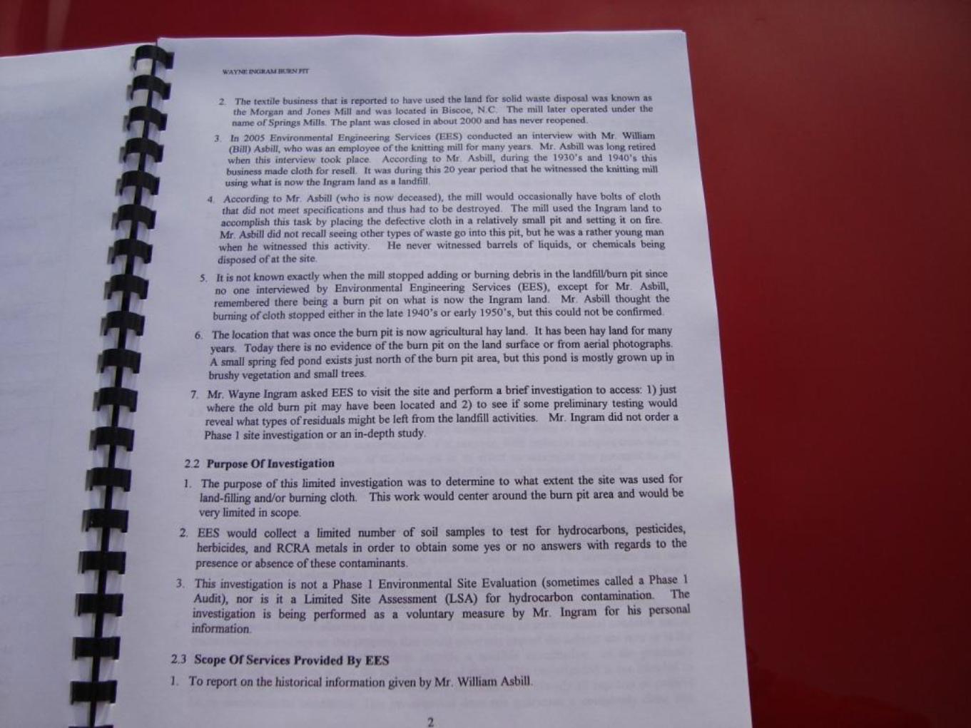
Mr. David Asbill, Superintendent Public Works Department for the Town of Biscoe, was
aware of the location of the Hurley’s Dump.
Mr. Asbill said Hurley’s Dump was between the towns of Biscoe and Star and was
located across US-220 Alt from the Food King grocery store. He stated that the Site is an
agricultural field.
Mr. Asbill did not know if the Town of Biscoe or the Town of Star used the Dump
because it was in operation before he was born.
Mr. Asbill did not know the dates of operation.
Mr. Asbill stated that yarn and cloth from the Morgan and Jones Mill was placed in the
Dump and he remembers seeing paper, cans, and bottles at the Site. He does not think
that hazardous materials (oil, paint, or gas) were placed at the Site.
Mr. Asbill stated that the Town of Biscoe does not have any records pertaining to
Hurley’s Dump. He said that he has asked other town officials about records pertaining to
the Site and they do not know of any records for the Hurley’s Dump.
Mr. Asbill stated that everyone he knows who may know something about that Site has
passed away. Schnabel asked him about Mr. Bobby Myrick (owner of Myrick
Construction Inc, located just south of the Site) and Mr. Asbill stated that Mr. Myrick has
lived in the area his whole life.
Mr. Bobby Myrick, Myrick Construction Inc., was aware of the location of the Hurley’s
Dump. He stated that the dump was located on Mr. Wayne Ingram’s property.
Mr. Myrick stated that the Towns of Biscoe and Star used the Hurley’s Dump because it
was centrally located between the towns.
Mr. Myrick stated that the Dump was operating about 50 years ago and it opened and
closed within a short amount of time.

Hurley’s Dump NONCD 0000435
7
Mr. Myrick stated that household waste was placed in Hurley’s Dump and that the
Morgan and Jones Mill also used that Dump to dispose of yarn and cloth. He was
interested in buying that property at one time, but remembered that the Dump was there
and decided against buying that land.
Mr. Wayne Ingram, property owner, was aware that the Hurley’s Dump was located on
his property.
Mr. Ingram gave verbal permission to access his property and would accompany
Schnabel staff on the site visit.
Mr. Ingram stated that the dump was small. He said that the Deed indicates 8 acres, but
the dumping site was not that large.
Mr. Ingram informed Schnabel staff that an environmental report was conducted on this
Site in 2007 by Environmental Engineering Services (EES).
Mr. Ingram showed Schnabel staff the location of the Disposal Area. He said that fescue
grass is grown on the Disposal Area.
Mr. Ingram provided Schnabel with some history of the Site. He said that a pit was
excavated to a depth of about 3 feet to 4 feet and textile material from Springs Mill (prior
name was Morgan and Jones Mill) was placed in a pit and burned. Springs Mill later
closed in 2000.
Mr. Ingram stated that the town did not use this Disposal Area for dumping and
hazardous material was not reportedly dumped or encountered in the pit.
Mr. Ingram stated that the nearby residences are served by a public water supply.
Mr. Ingram stated that he will likely remove the debris material from the Site and dispose
of it properly.
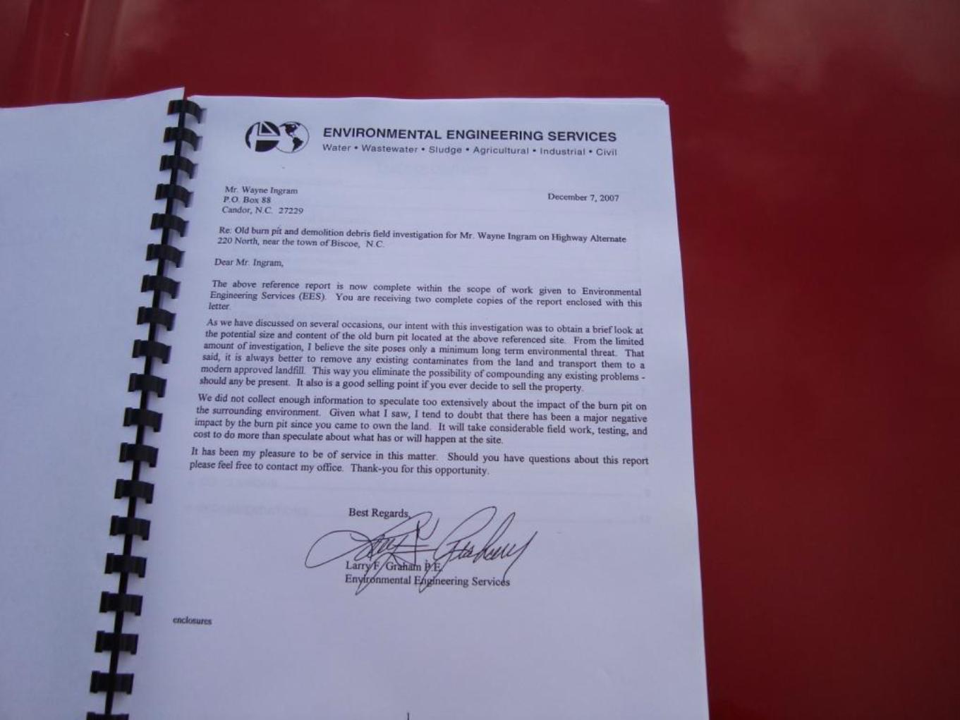
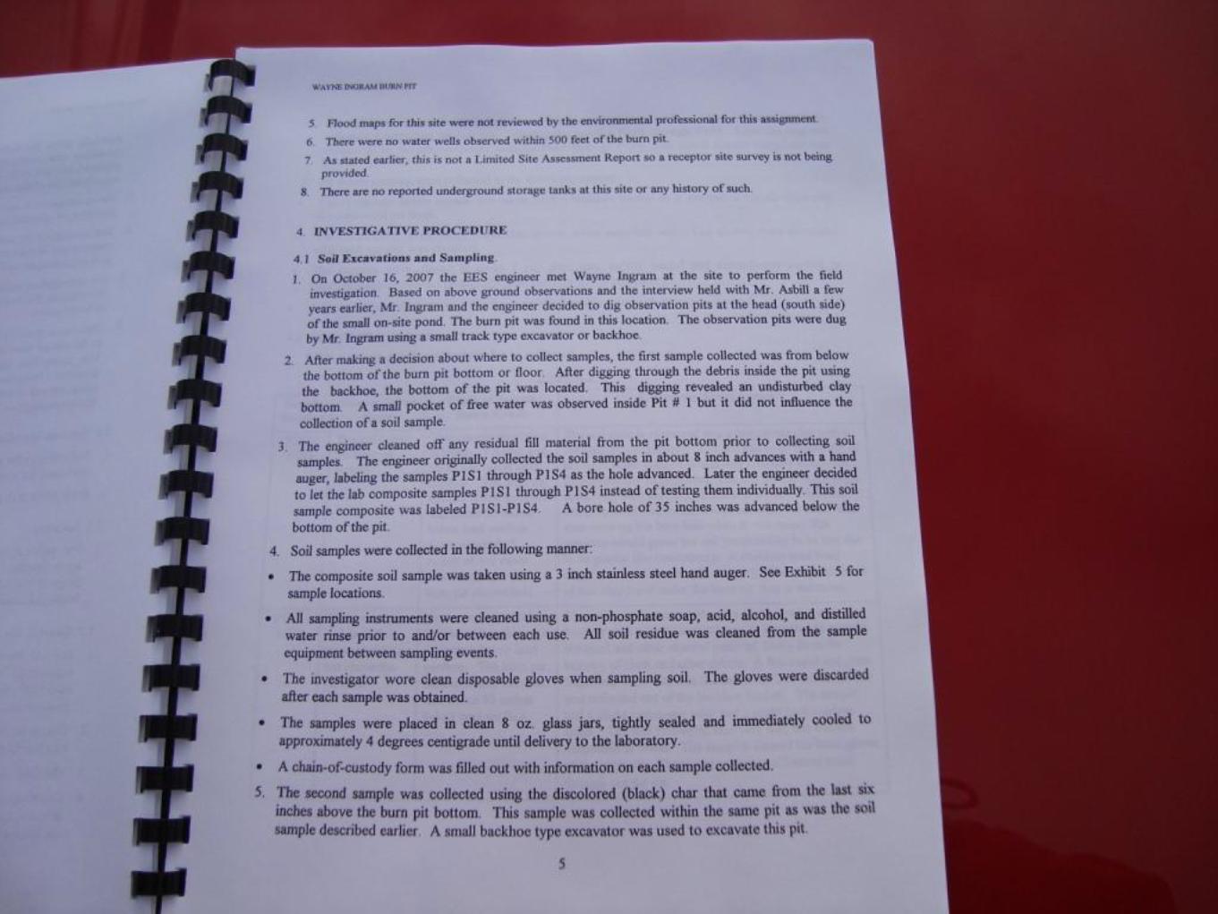
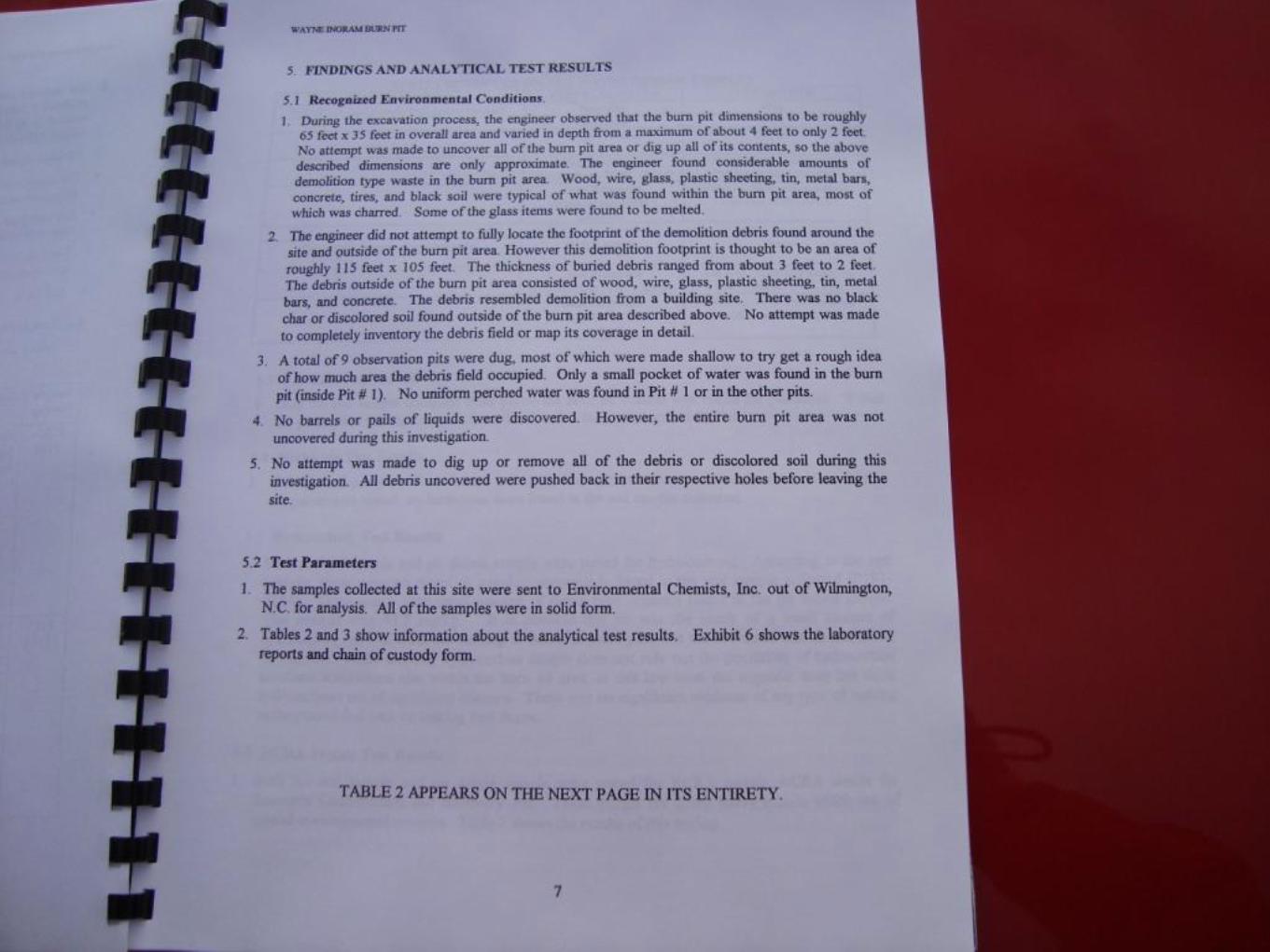
The EES report, Soils Investigation for Wayne Ingram at an Old Burn Pit Site in Biscoe, NC,
reported the following:
EES excavated test pits and encountered charcoal material, glass, and metal debris in the
pit. The pit was surrounded by demolition material consisting of concrete, wood, wire,
glass, plastic sheeting, tin, and metal bars to the west, east and south. The debris material
was approximately 2 feet to 3 feet in thickness. The entire Disposal Area was not

Hurley’s Dump NONCD 0000435
8
uncovered in the investigation, but limits of the Disposal Area were estimated to be
approximately 115 feet by 105 feet.
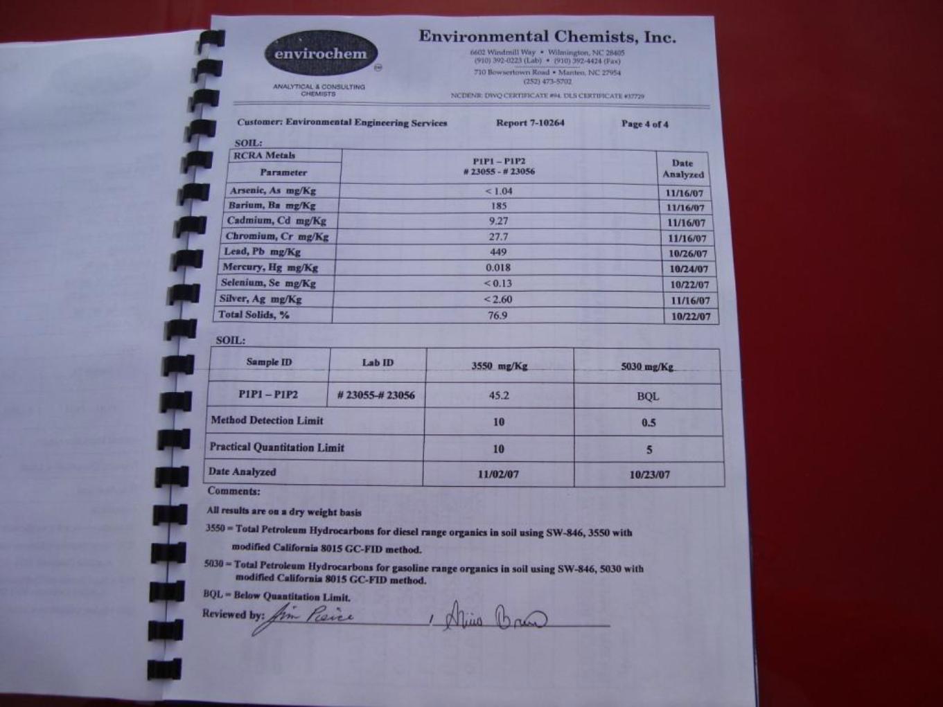
EES collected a soil sample from the below the burn pit and a pit debris sample at the
Site. The samples were tested for pesticides, herbicides, hydrocarbon, and RCRA metals
consisting of arsenic, barium, cadmium, chromium, lead, mercury, selenium, and silver
(see page 8 of the EES report). No pesticides or herbicides were detected in the soil
sample from below the burn pit. Diesel and gasoline were not found in the soil sample
below the burn pit, but small amounts of diesel type organics were found in the pit debris
sample at 45.2 mg/kg. This was possibly from the burning of debris within the pit
because evidence that the pit was used to dispose of oil, fuels, or solvents was not
encountered. The results from the RCRA metals analysis (see Table 3, page 9 of the EES
report) detected higher concentrations of metals from the pit debris sample than the soil
sample from below the burn pit. The soil below the burn pit was likely impacted from the
burning of debris, but this impact was relatively low.
Notes from conversations with people familiar with the site are included in Appendix C. The
information obtained from these conversations has not been verified or confirmed.

Hurley’s Dump NONCD 0000435
9
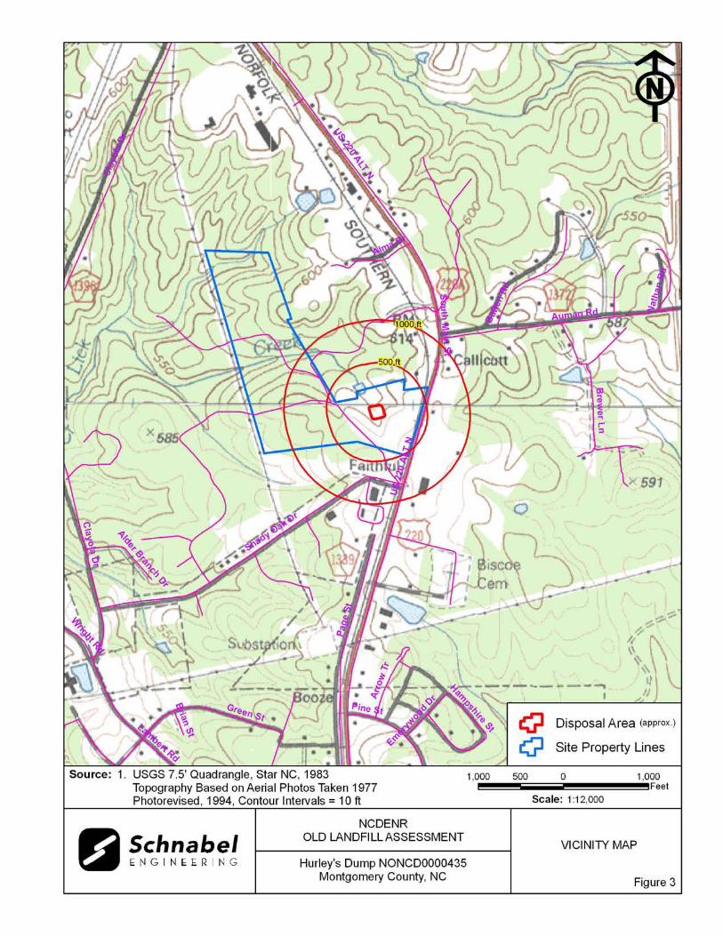
2.0 VICINITY CONDITIONS
This section describes the observed general conditions in the vicinity of the Site, as defined as an
area within 1,000 feet of the perimeter of the Disposal Area. Photographs illustrating vicinity
conditions are included in Appendix D.
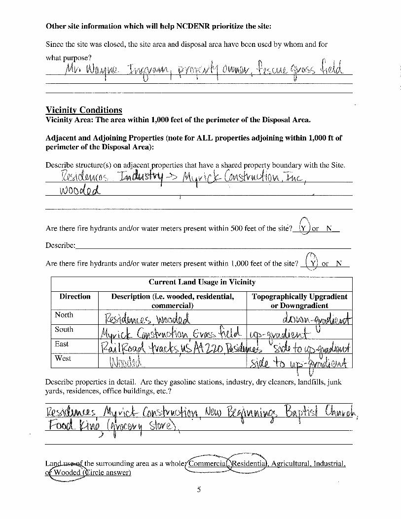
2.1 Structures Located on Adjacent Properties
Structures described in this section are located on adjacent properties that have a shared property
boundary with the Site.
A residence is located to the north on Tax Parcel 7569-00-82-1528 and Myrick Construction,
Inc. is located to the south on Tax Parcel 7569-19-71-0696 of the Site. The property is wooded to
the west of the Disposal Area and railroad tracks and US-220 Alt are located to the east. These
structures are shown on Figure 2 and on aerial photographs in Appendix E.
2.2 Water Supply Wells and Intakes
Water supply wells or well houses were not observed at residences along US-220 Alt (North
Main Street) within a 1,000-foot radius of the Disposal Area. Water meters were observed in the
yards of several of the residences within 1,000 feet of the Site. Fire hydrants were observed
within 1,000 feet of the Site. According to Mr. Wayne Ingram, property owner, the area within
1,000 feet of the Disposal Area perimeter is served by a public water supply.

Hurley’s Dump NONCD 0000435
10
2.3 Current Land Usage
Property in the vicinity of the Site is primarily residential and commercial, except for the area to
the west. Land usage at the time of the site visit within 1,000 feet of the Disposal Area perimeter
was:
North: Residences and wooded, apparent down-gradient direction from the Site. South: Myrick Construction, Inc., apparent up-gradient direction from the Site. East: Railroad tracks, US-220 Alt, residences, Food King grocery store, and New
Beginnings Baptist Church property, apparent side- to up-gradient direction from the Site.
West: Wooded, apparent side- to up-gradient direction from the Site.
2.4 Surface Water Features
Lick Creek flows to the west and is located to the north of the Site within 1,000 feet.

Hurley’s Dump NONCD 0000435
11
3.0 AERIAL PHOTOGRAPHY REVIEW
Aerial photographs were reviewed for the years 1950, 1956, 1968, 1983, and 2005. The reported
years of operation of the Site were from 1930’s to early 1950’s. Observations of each of the
photographs are included in the following table. Copies of the aerial photographs are included in
Appendix E. Some aerial photographs are reproductions of original aerial photographs and have
some distortion; therefore, overlaid Disposal Area Boundaries and other features may vary from
their actual locations. Hand drawn lines and notations on the photographs denote soils mapping
information drawn on the original photographs by the USDA NRCS.
Flight Year Observations Source
1950 The Disposal Area is covered with grass. The Site is cleared and covered with vegetation. Residences are visible to the northeast and south of the Site along US-220 Alt.
1
1956 The Disposal Area is covered with grass. A darker area on the northwestern portion of the Disposal Area is present. The pond is visible to the north of the Disposal Area. The structure seen in the 1950 aerial photograph on the southern portion of the Site is no longer visible.
1
1968 The Disposal Area is covered with grass. The western portion of the Site is covered with trees. Residences and commercial properties are visible to the north, east and southeast of the Site.
1
1983 The Disposal Area is covered with grass. Myrick Construction, Inc. is visible to the south of the Site.
1
2005 The Disposal Area is covered with grass. Myrick Construction, Inc. buildings are now adjacent to the south of the Site. The aerial photograph shows conditions representative of those observed during the visit.
2
Sources of aerial photos: 1) USDA NRCS office in Troy, NC 2) Montgomery County GIS,
ftp://204.211.239.203/outgoing/raster/local_imagery/montgomery2005
This report was prepared specifically for the use of NCDENR Inactive Sites Branch under the Scope of Work defined in our contract dated October 26, 2005. Use of this document for other purposes or by other parties is at the sole risk of the user.

TABLE
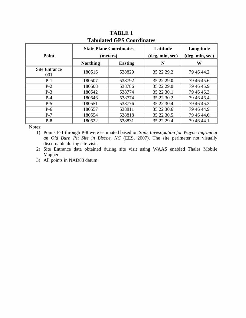
TABLE 1
Tabulated GPS Coordinates
Point
State Plane Coordinates
(meters)
Latitude
(deg, min, sec)
Longitude
(deg, min, sec)
Northing Easting N W Site Entrance
001 180516 538829 35 22 29.2 79 46 44.2
P-1 180507 538792 35 22 29.0 79 46 45.6 P-2 180508 538786 35 22 29.0 79 46 45.9 P-3 180542 538774 35 22 30.1 79 46 46.3 P-4 180546 538774 35 22 30.2 79 46 46.4 P-5 180551 538776 35 22 30.4 79 46 46.3 P-6 180557 538811 35 22 30.6 79 46 44.9 P-7 180554 538818 35 22 30.5 79 46 44.6 P-8 180522 538831 35 22 29.4 79 46 44.1
Notes: 1) Points P-1 through P-8 were estimated based on Soils Investigation for Wayne Ingram at
an Old Burn Pit Site in Biscoe, NC (EES, 2007). The site perimeter not visually discernable during site visit.
2) Site Entrance data obtained during site visit using WAAS enabled Thales Mobile Mapper.
3) All points in NAD83 datum.


FIELD RECONNAISSANCE SHEET


TAX RECORDS

Montgomery County, NC
DISCLAIMER: The information contained on this page is NOT to be construed or used as a "legal description". Map information is believed to be accurate but accuracy is not guaranteed.
Parcels
Parcel No: 7569 00 52 7436 Parcel Address: 0 US HWY 220 ALT Parcel Owner: INGRAM, WAYNE PO BOX 828
BISCOE, NC 27209
Lot Number: Legal Description: Deed Reference: Bk. 249 Pg. 439 Land Area: 119.70A acres Year Built:
Building Value: $0 Land Value: $66,731 Other Value: $0 Total Tax Value: $66,700 Sale Year: 91 Sale Price: $293,000
http://www.webgis.net Anderson & Associates, Inc. http://www.andassoc.com
Page 1 of 1Montgomery Co., NC -- Printable Map
2/11/2010http://arcims.webgis.net/nc/montgomery/printable2.asp

RECORDS OF COMMUNICATION SITE VISIT PERMISSION LETTER


G:\2006_projects\06210002_(NCDENR_Old_Unlined_Landfill)\Task_23_Montgomery_Co\0435-Hurley'sDump\Report\Final\RecOfConv-
DavidAsbill-2010-02-03.doc
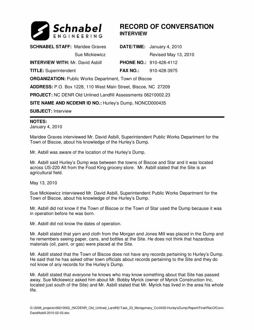
RECORD OF CONVERSATION INTERVIEW
SCHNABEL STAFF: Maridee Graves DATE/TIME: January 4, 2010
Sue Mickiewicz Revised May 13, 2010
INTERVIEW WITH: Mr. David Asbill PHONE NO.: 910-428-4112
TITLE: Superintendent FAX NO.: 910-428-3975
ORGANIZATION: Public Works Department, Town of Biscoe
ADDRESS: P.O. Box 1228, 110 West Main Street, Biscoe, NC 27209
PROJECT: NC DENR Old Unlined Landfill Assessments 06210002.23
SITE NAME AND NCDENR ID NO.: Hurley’s Dump, NONCD000435
SUBJECT: Interview
NOTES: January 4, 2010 Maridee Graves interviewed Mr. David Asbill, Superintendent Public Works Department for the Town of Biscoe, about his knowledge of the Hurley’s Dump. Mr. Asbill was aware of the location of the Hurley’s Dump. Mr. Asbill said Hurley’s Dump was between the towns of Biscoe and Star and it was located across US-220 Alt from the Food King grocery store. Mr. Asbill stated that the Site is an agricultural field. May 13, 2010 Sue Mickiewicz interviewed Mr. David Asbill, Superintendent Public Works Department for the Town of Biscoe, about his knowledge of the Hurley’s Dump. Mr. Asbill did not know if the Town of Biscoe or the Town of Star used the Dump because it was in operation before he was born. Mr. Asbill did not know the dates of operation. Mr. Asbill stated that yarn and cloth from the Morgan and Jones Mill was placed in the Dump and he remembers seeing paper, cans, and bottles at the Site. He does not think that hazardous materials (oil, paint, or gas) were placed at the Site. Mr. Asbill stated that the Town of Biscoe does not have any records pertaining to Hurley’s Dump. He said that he has asked other town officials about records pertaining to the Site and they do not know of any records for the Hurley’s Dump. Mr. Asbill stated that everyone he knows who may know something about that Site has passed away. Sue Mickiewicz asked him about Mr. Bobby Myrick (owner of Myrick Construction Inc, located just south of the Site) and Mr. Asbill stated that Mr. Myrick has lived in the area his whole life.

G:\2006_projects\06210002_(NCDENR_Old_Unlined_Landfill)\Task_23_Montgomery_Co\0435-Hurley'sDump\Report\Final\RecOfConv-
BobbyMyrick-2010-02-03.doc
RECORD OF CONVERSATION INTERVIEW
SCHNABEL STAFF: Sue Mickiewicz DATE/TIME: January 26, 2010
Revised May 13, 2010
INTERVIEW WITH: Mr. Bobby Myrick PHONE NO.: 910-572-7957
TITLE: Owner FAX NO.:
ORGANIZATION: Myrick Construction, Inc.
ADDRESS: P.O. Box 728, Biscoe, NC 27209
PROJECT: NC DENR Old Unlined Landfill Assessments 06210002.23
SITE NAME AND NCDENR ID NO.: Hurley’s Dump, NONCD000435
SUBJECT: Interview
NOTES: January 26, 2010 Sue Mickiewicz interviewed Mr. Bobby Myrick, owner of Myrick Construction, Inc., about his knowledge of the Hurley’s Dump. Mr. Myrick was aware of the location of the Hurley’s Dump. He stated that the dump was located on the Mr. Wayne Ingram’s property. May 13, 2010 Sue Mickiewicz interviewed Mr. Bobby Myrick, owner of Myrick Construction, Inc., about his knowledge of the Hurley’s Dump. Myrick Construction Inc. is located on a property adjacent to Hurley’s Dump. Mr. Myrick stated that the Towns of Biscoe and Star used the Hurley’s Dump because it was centrally located between the towns. Mr. Myrick stated that the Dump was operating about 50 years ago and it opened and closed within a short amount of time. Mr. Myrick stated that household waste was placed in Hurley’s Dump and that the Morgan and Jones Mill also used that Dump to dispose of yarn and cloth. He was interested in buying that property at one time, but remembered that the Dump was there and decided against buying that land.
G:\2006_projects\06210002_(NCDENR_Old_Unlined_Landfill)\Task_23_Montgomery_Co\0435-
Hurley'sDump\Report\Final\RecOfConv-WayneIngram-2010-02-03.doc
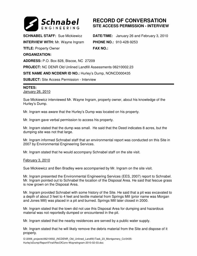
RECORD OF CONVERSATION SITE ACCESS PERMISSION - INTERVIEW
SCHNABEL STAFF: Sue Mickiewicz DATE/TIME: January 26 and February 3, 2010
INTERVIEW WITH: Mr. Wayne Ingram PHONE NO.: 910-428-9253
TITLE: Property Owner FAX NO.:
ORGANIZATION:
ADDRESS: P.O. Box 828, Biscoe, NC 27209
PROJECT: NC DENR Old Unlined Landfill Assessments 06210002.23
SITE NAME AND NCDENR ID NO.: Hurley’s Dump, NONCD000435
SUBJECT: Site Access Permission - Interview
NOTES: January 26, 2010 Sue Mickiewicz interviewed Mr. Wayne Ingram, property owner, about his knowledge of the Hurley’s Dump. Mr. Ingram was aware that the Hurley’s Dump was located on his property. Mr. Ingram gave verbal permission to access his property. Mr. Ingram stated that the dump was small. He said that the Deed indicates 8 acres, but the dumping site was not that large. Mr. Ingram informed Schnabel staff that an environmental report was conducted on this Site in 2007 by Environmental Engineering Services. Mr. Ingram stated that he would accompany Schnabel staff on the site visit. February 3, 2010 Sue Mickiewicz and Ben Bradley were accompanied by Mr. Ingram on the site visit. Mr. Ingram presented the Environmental Engineering Services (EES, 2007) report to Schnabel. Mr. Ingram pointed out to Schnabel the location of the Disposal Area. He said that fescue grass is now grown on the Disposal Area. Mr. Ingram provided Schnabel with some history of the Site. He said that a pit was excavated to a depth of about 3 feet to 4 feet and textile material from Springs Mill (prior name was Morgan and Jones Mill) was placed in a pit and burned. Springs Mill later closed in 2000. Mr. Ingram stated that the town did not use this Disposal Area for dumping and hazardous material was not reportedly dumped or encountered in the pit. Mr. Ingram stated that the nearby residences are served by a public water supply. Mr. Ingram stated that he will likely remove the debris material from the Site and dispose of it properly.

G:\2006_projects\06210002_(NCDENR_Old_Unlined_Landfill)\Task_23_Montgomery_Co\0435-
Hurley'sDump\Report\Final\RecOfConv-WayneIngram-2010-02-03.doc
The EES report, Soils Investigation for Wayne Ingram at an Old Burn Pit Site in Biscoe, NC, reported the following:
• EES excavated test pits and encountered charcoal material, glass, and metal debris in the pit. The pit was surrounded by demolition material consisting of concrete, wood, wire, glass, plastic sheeting, tin, and metal bars to the west, east and south. The debris material was approximately 2 feet to 3 feet in thickness. The entire Disposal Area was not uncovered in the investigation, but limits of the Disposal Area were estimated to be approximately 115 feet by 105 feet.
• EES collected a soil sample from the below the burn pit and a pit debris sample at the Site. The samples were tested for pesticides, herbicides, hydrocarbon, and RCRA metals consisting of arsenic, barium, cadmium, chromium, lead, mercury, selenium, and silver (see page 8 of the EES report). No pesticides or herbicides were detected in the soil sample from below the burn pit. Diesel and gasoline were not found in the soil sample below the burn pit, but small amounts of diesel type organics were found in the pit debris sample at 45.2 mg/kg. This was possibly from the burning of debris within the pit because evidence that the pit was used to dispose of oil, fuels, or solvents was not encountered. The results from the RCRA metals analysis (see Table 3, page 9 of the EES report) detected higher concentrations of metals from the pit debris sample than the soil sample from below the burn pit. The soil below the burn pit was likely impacted from the burning of debris, but this impact was relatively low.

SITE PHOTOGRAPHS
Hurley’s Dump, NONCD0000435
PHOTOGRAPH No.: 1
Photo Taken: 02-03-10
LOCATION:
Site entrance from Shady Oak Drive.
COMMENTS:
Photo taken facing toward the south. Fescue grass field.
PHOTOGRAPH No.: 2
Photo Taken: 02-03-10
LOCATION:
Disposal Area and Site from US-220 Alt.
COMMENTS:
Photo taken facing toward the west. Pond in upper right corner of photograph.

Hurley’s Dump, NONCD0000435
PHOTOGRAPH No.: 3
Photo Taken: 02-03-10
LOCATION:
North and central portion of Disposal Area.
COMMENTS:
Fescue grass field and pond to the north of the Disposal Area.
PHOTOGRAPH No.: 4
Photo Taken: 02-03-10
LOCATION:
Disposal Area.
COMMENTS:
Brick found in fescue grass field.

AERIAL PHOTOGRAPHS


SUPPORTING DOCUMENTATION