SITE SUMMARY REPORT Greensboro City Landfill NCD991279027 ... · PDF fileSITE SUMMARY REPORT ....
92
SITE SUMMARY REPORT Greensboro City Landfill NCD991279027 Guilford County Senate Bill 1492 State of North Carolina State Contract N06009S Schnabel Project No. 06210002.29 July 30, 2010 Revised September 20, 2010 Prepared for: North Carolina Department of Environment and Natural Resources Superfund Section Inactive Hazardous Sites Branch 401 Oberlin Road, Suite 150 Raleigh, NC 27605 Prepared by: Schnabel Engineering South, P.C. 11-A Oak Branch Drive Greensboro, North Carolina 27407 (336) 274-9456 Susan A. Mickiewicz Staff Scientist/Report Author Signature Gregory Kuntz, L.G. Senior Associate/Reviewer Signature
Transcript of SITE SUMMARY REPORT Greensboro City Landfill NCD991279027 ... · PDF fileSITE SUMMARY REPORT ....

SITE SUMMARY REPORT Greensboro City Landfill
NCD991279027 Guilford County
Senate Bill 1492
State of North Carolina State Contract N06009S
Schnabel Project No. 06210002.29
July 30, 2010 Revised September 20, 2010
Prepared for:
North Carolina Department of Environment and Natural Resources Superfund Section
Inactive Hazardous Sites Branch 401 Oberlin Road, Suite 150
Raleigh, NC 27605
Prepared by:
Schnabel Engineering South, P.C.
11-A Oak Branch Drive Greensboro, North Carolina 27407
(336) 274-9456
Susan A. MickiewiczStaff Scientist/Report Author Signature
Gregory Kuntz, L.G.Senior Associate/Reviewer Signature
TABLE OF CONTENTS
Site Location Research Summary Areas of Note Site Summary
1.0 Site Conditions 1.1 On-site Structures 1.2 Current Site Usage 1.3 On-site Water Supply Wells and Intakes 1.4 Surface Water Features 1.5 Disposal Area 1.6 Disposal Area Conditions 1.7 Evidence of Human Activity 1.8 Potential Landfill Gas Migration Pathways 1.9 Physical Barriers 1.10 Other Pertinent Information
2.0 Vicinity Conditions
2.1 Structures Located on Adjacent Properties 2.2 Water Supply Wells and Intakes 2.3 Current Land Usage 2.4 Surface Water Features
3.0 Aerial Photography Review
TABLES Table 1 Tabulated GPS Coordinates
FIGURES Figure 1 USGS Topographic Map Figure 2 Site Map Figure 3 Vicinity Map Figure 4 Topographic Map Overlaid On LiDAR Shaded Relief Figure 5 LiDAR Shaded Relief
APPENDICES Appendix A Field Reconnaissance Sheet Appendix B Tax Records Appendix C Records of Communication\Site Visit Permission Letter Appendix D Site Photographs Appendix E Aerial Photographs Appendix F Supporting Documentation FILE: G:\2006_PROJECTS\06210002_(NCDENR_OLD_UNLINED_LANDFILL)\TASK_29_GUILFORD_CO\9027-GREENSBOROCITYLANDFILL\REPORT\FINAL\NCD991279027_GREENSBOROCITYLANDFILL_SITESUMMARYREPORT_2010-09-20.DOC

Greensboro City Landfill NCD991279027
1
SITE LOCATION RESEARCH SUMMARY ID NUMBER: NCD991279027 SITE NAME(S): Greensboro City Landfill LOCATION: 2199 White Street, Greensboro, NC 27402 COUNTY: Guilford LANDFILL SIZE: 75.8 acres (Disposal Area enclosed by GPS points obtained during site
visit and perimeter identified from aerial photographs and LiDAR images)
PROPERTY SIZE: 130.5 acres (from Guilford County GIS) DATE OPENED: Approximately 1948 (data obtained from NCDENR Inventory Record) DATE CLOSED: Approximately late 1960s (data obtained from Mr. Arthur White,
Engineer for Hazen and Sawyer, and historical aerial photographs) PARCEL 1 CURRENT OWNER: City of Greensboro CURRENT OWNER CONTACT: Mr. Nathan Osborne, Water Reclamation Plant
Supervisor CURRENT OWNER ADDRESS: P.O. Box 3136, Greensboro, NC 27402 CURRENT OWNER TELEPHONE NUMBER: 336-373-7850 TAX PARCEL No./PIN No.: 0079176/7885091468 DEED REFERENCE: Deed Book 1849, Page 431 PROPERTY SIZE: 92.6 acres (from Guilford County GIS) The Disposal Area appears to extend onto the following tax parcels: PARCEL 2 CURRENT OWNER: City of Greensboro CURRENT OWNER CONTACT: Mr. Nathan Osborne, Water Reclamation Plant
Supervisor CURRENT OWNER ADDRESS: P.O. Box 3136, Greensboro, NC 27402 CURRENT OWNER TELEPHONE NUMBER: 336-373-7850 TAX PARCEL No./PIN No.: 0079129/7885197028 DEED REFERENCE: Deed Book 350, Page 918 PROPERTY SIZE: 7.6 acres (from Guilford County GIS)
Greensboro City Landfill NCD991279027
2
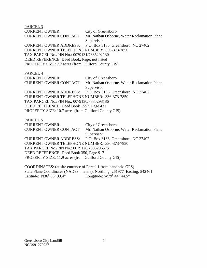
PARCEL 3 CURRENT OWNER: City of Greensboro CURRENT OWNER CONTACT: Mr. Nathan Osborne, Water Reclamation Plant
Supervisor CURRENT OWNER ADDRESS: P.O. Box 3136, Greensboro, NC 27402 CURRENT OWNER TELEPHONE NUMBER: 336-373-7850 TAX PARCEL No./PIN No.: 0079131/7885292130 DEED REFERENCE: Deed Book, Page: not listed PROPERTY SIZE: 7.7 acres (from Guilford County GIS) PARCEL 4 CURRENT OWNER: City of Greensboro CURRENT OWNER CONTACT: Mr. Nathan Osborne, Water Reclamation Plant
Supervisor CURRENT OWNER ADDRESS: P.O. Box 3136, Greensboro, NC 27402 CURRENT OWNER TELEPHONE NUMBER: 336-373-7850 TAX PARCEL No./PIN No.: 0079130/7885298186 DEED REFERENCE: Deed Book 1557, Page 431 PROPERTY SIZE: 10.7 acres (from Guilford County GIS) PARCEL 5 CURRENT OWNER: City of Greensboro CURRENT OWNER CONTACT: Mr. Nathan Osborne, Water Reclamation Plant
Supervisor CURRENT OWNER ADDRESS: P.O. Box 3136, Greensboro, NC 27402 CURRENT OWNER TELEPHONE NUMBER: 336-373-7850 TAX PARCEL No./PIN No.: 0079128/7885296575 DEED REFERENCE: Deed Book 350, Page 917 PROPERTY SIZE: 11.9 acres (from Guilford County GIS) COORDINATES: (at site entrance of Parcel 1 from handheld GPS) State Plane Coordinates (NAD83, meters): Northing: 261977 Easting: 542461 Latitude: N36o 06’ 33.4” Longitude: W79o 44’ 44.5”

Greensboro City Landfill NCD991279027
3
AREAS OF NOTE
1. Waste appears to extend onto tax parcels 0079129, 0079131, 0079130, and 0079128 owned by the City of Greensboro on the North Buffalo Creek Sewage Treatment Plant property.
2. Based on the 1966 aerial photograph, the eastern perimeter of the Disposal Area is uncertain because the Greensboro City Landfill appears to extend into the White Street Landfill property on the eastern part of the Disposal Area.
3. The North Buffalo Creek Sewage Treatment Plant is located on Site, west and north of the Disposal Area.
4. Residences, the White Street Landfill, the E.H. Glass County Landfill, Greensboro Sportsplex, and the Evangel Fellowship Church of God are located within 1,000 feet of the Disposal Area.
5. There is evidence of human activity on the Disposal Area as indicated by large tree
stumps and berms, remnants of a concrete bridge, gravel/grass roadways, sewer line with manholes, and a locked gate on the southern boundary.
6. Potential landfill gas migration pathways observed on the Disposal Area and Site include
backfill along underground utilities including a sewer line with manholes, holes in landfill slope, animal burrows, and the North Buffalo Creek Sewage Treatment Plant.
7. The North Buffalo Creek is located along the northern perimeter of the Site and Disposal Area. Muddy Creek flows northward into North Buffalo Creek through the west central part of the Disposal Area. An unnamed perennial stream flows northward into North Buffalo Creek through the east central part of the Disposal Area.
8. The 100 year floodplain of the North Buffalo Creek, Muddy Creek and the unnamed
perennial stream is located within the Disposal Area and Site.
9. Construction and demolition materials and composted sludge from the North Buffalo Creek Sewage Treatment Plant were reportedly placed on the western portion of the Disposal Area through the early 1990s after the Greensboro City Landfill ceased operation.
10. Hummocky topography, landfill slopes, berms, linear depressions, and stained soil were
observed on the Disposal Area.
11. Exposed debris observed on the Disposal Area consisted of bricks, concrete, asphalt, steel/concrete/plastic piping, glass and plastic bottles, tires, plastics, white goods, vehicle parts, scrap metal, metal cans, 55-gallon drums, paint cans, wood skids, tree limbs, mattresses, miscellaneous household waste, and remnants of a concrete bridge.

Greensboro City Landfill NCD991279027
4
12. Approximately 40 to 50 exposed 55-gallon drums were observed on the north central part
of the Disposal Area.
13. A well house is located off-site near the south side of the Disposal Area that is reportedly used for non-drinking water purposes.
Greensboro City Landfill NCD991279027
5
SITE SUMMARY
1.0 SITE CONDITIONS
This section discusses the observed conditions on the Site, as defined as the properties (Tax
Parcels 0079176, 0079129, 0079131, 0079130, and 0079128) on which the Disposal Area is
located. The Disposal Area is defined as the area observed or reported to have been used for
waste placement or burial. The boundary (perimeter) of this area is the observed limit of waste
material based on field observations and the inferred limit based on a review of historical aerial
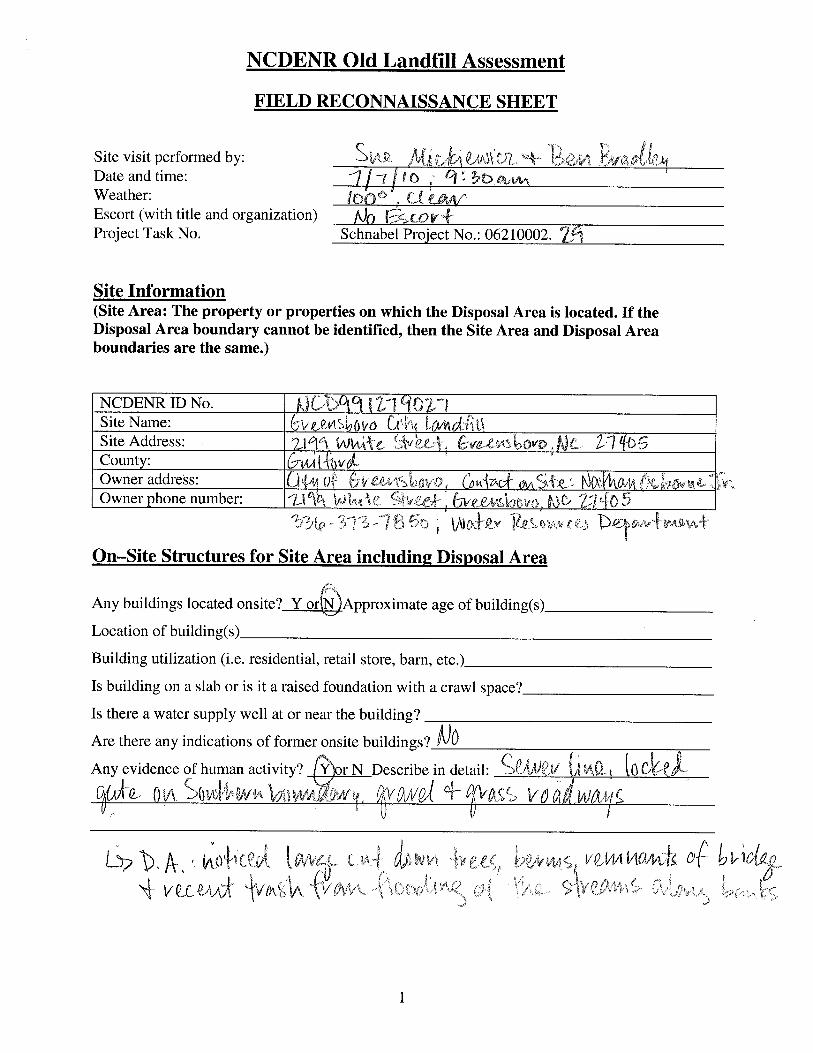
photographs or LiDAR images. The site visit was conducted on July 7, 2010. Photographs
illustrating site conditions are included in Appendix D.
The Site is located in Guilford County, near Greensboro, NC. Driving directions to the Site from
the intersection of Interstate 40 Business and NC Highway 6 (East Lee Street) are as follows:
1. West onto NC Highway 6 (East Lee Street) and drive approximately 1.6 miles.
2. Turn right onto South English Street and drive north approximately 2.5 miles
3. Turn left at Phillips Avenue and continue west about 0.4 miles.
4. Turn right onto White Street and drive approximately 1.0 mile to the North Buffalo Creek
Sewage Treatment Plant. An entrance to the Disposal Area is located to the east of the
main building at the Sewage Treatment Plant (Figure 2).
5. A second entrance to the Site and Disposal Area is located along White Street,
approximately 0.3 miles east from the entrance to the North Buffalo Creek Sewage
Treatment Plant (Figure 2).
1.1 On-site Structures
The North Buffalo Creek Sewage Treatment Plant is located about 500 feet from the western
perimeter of the Disposal Area on the Site.

Greensboro City Landfill NCD991279027
6
1.2 Current Site Usage
According to Mr. Nathan Osborne, Water Reclamation Plant Supervisor, the Site is used by the
North Buffalo Creek Sewage Treatment Plant and that the Disposal Area is no longer used.
1.3 On-Site Water Supply Wells and Intakes
No on-site water supply wells were observed on the Site during the site visit. No water meters or
fire hydrants were observed on the Site during the site visit.
1.4 Surface Water Features
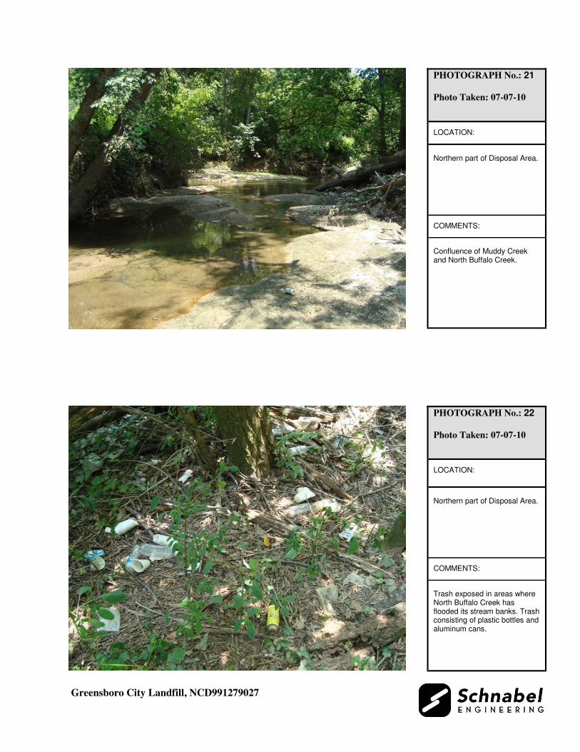
North Buffalo Creek is located along the northern perimeter of the Site and Disposal Area.
Review of topographic maps and aerial photographs suggest the creek crosses on and off the
northern perimeter of the Site based on past historical migration of the creek bed. The creek
originally included a meander on the eastern portion of the Site that was either cut off or filled so
that the present creek bed is located along the northern perimeter of the Site in this area. The
creek is approximately 40 feet wide with a sand/gravel bed, and had clear flowing water at the
time of the site visit. Recent disposal material consisting of plastics and plastic bottles was
observed in the creek and along the creek banks at the time of the site visit. Disposal material
consisting of plastic bottles and aluminum cans was located approximately six feet above the
creek bed along the bank indicating that North Buffalo Creek had overtopped its banks during a
flooding event (Photo 22).
Muddy Creek is located on the west central part of the Disposal Area. Muddy Creek flows
northward through the Disposal Area into North Buffalo Creek (Photo 21). Muddy Creek is
approximately 40 feet wide with a sand/gravel bed, and had clear flowing water at the time of the
site visit. Disposal material consisting of plastics, glass, hosing, metal, tires, and white goods
were observed in Muddy Creek at the time of the site visit (Photo 20).

Greensboro City Landfill NCD991279027
7
An unnamed perennial stream is located on the east central part of the Disposal Area. This
unnamed perennial stream flows through the Disposal Area northward into North Buffalo Creek.
The unnamed perennial stream was not observed at the time of the site visit.
The 100 year floodplain of the North Buffalo Creek, Muddy Creek and the unnamed perennial
stream is located within the Disposal Area and Site.
1.5 Disposal Area
Access to the Disposal Area is from the North Buffalo Creek Sewage Treatment Plant property
off of White Street (Photo 1). A second access point is located along White Street near the
southern perimeter of the Disposal Area (Photo 16). The Disposal Area occupies 75.8 acres
based on the estimated Disposal Area perimeter shown on Figures 1 through 3.
The ground surface of the Disposal Area slopes relatively uniformly toward the north-northeast.
A comparison of the topography from the 1952 USGS 7.5 minute topographic quadrangle map
(10 foot contours, based on 1971 aerial photography) with the 2005 topographic map from
NCDOT (4 foot contours), indicates the following topographic changes:
• There are no significant changes in topography between the 1952 topographic map and
the 2005 topographic map in the southwest part of the Disposal Area off-Site across
White Street.
• West of Muddy Creek, the area appears to have been filled with up to 10 to 20 feet of
disposal material.
• Closely spaced contours (indicating steep elevation change) on the 2005 topographic map
are located on the western side of Muddy Creek. The change in topography indicates a
steep 40 foot eastward facing slope. This slope appears to have been filled with up to 10
feet of disposal material.
• Muddy Creek appears to have been shifted to the west and north and filled with up to 10
feet of disposal material.

Greensboro City Landfill NCD991279027
8
• The central part of the Disposal Area, between Muddy Creek and the unnamed perennial
stream, appears to have been filled with up to 10 to 20 feet of disposal material.
• Along the northern perimeter of the Disposal Area, south of North Buffalo Creek on the
central part of the Disposal Area, a steep 20 foot high northward facing slope is indicated
on the 2005 topographic map. This area may have been filled with up to 20 feet of
disposal material.
• The unnamed perennial stream located on the east central part of the Disposal Area
appears to have been shifted to the east and may have been filled with up to 10 to 20 feet
of disposal material.
• The eastern part of the Disposal Area appears to have been filled with up to 10 to 30 feet
of disposal material.
• On the 1952 topographic map, the North Buffalo Creek meanders into the eastern part of
the Disposal Area. The 2005 topographic map indicates that this meander of North
Buffalo Creek has been cut off and may have been filled in with up to 30 to 40 feet of
disposal material.
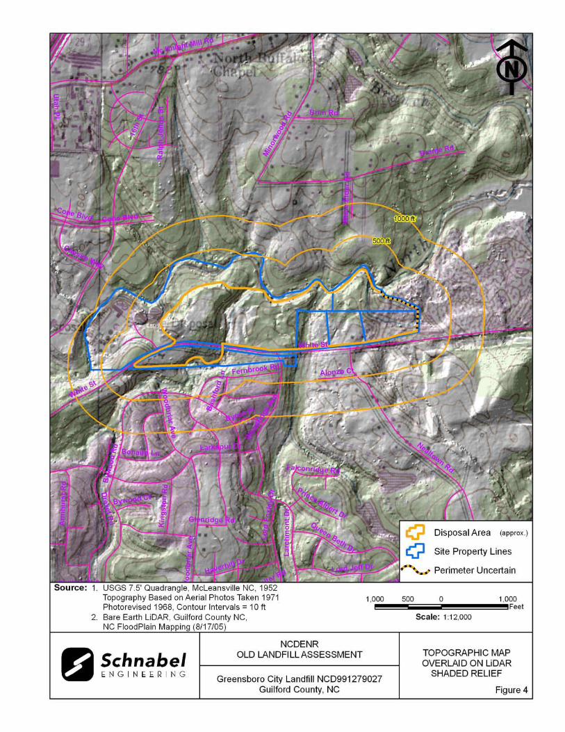
The topographic changes described above are also evident on the LiDAR Shaded Relief map
(Figure 5). Linear features on the central and eastern portions of the Disposal Area are apparent
on the LiDAR image. These features are landfill slopes that were observed during the site visit.
The LiDAR image also suggests that the meander of North Buffalo Creek on the eastern part of
the Disposal Area has been filled with disposal material.
The depth of waste is estimated based on a comparison of topographic maps of different vintages
constructed using different methods. The reported years of operation were from 1948 to the late
1960s, so the 1952 USGS map may have represented the land surface at or near the beginning of
the disposal period. Differences between elevations on the maps may reflect actual elevation
changes or may be apparent differences due to the different map making methods. The elevation
comparisons are approximate and differences in scale and methods of mapping are not sufficient
to evaluate some changes in topography.
Greensboro City Landfill NCD991279027
9
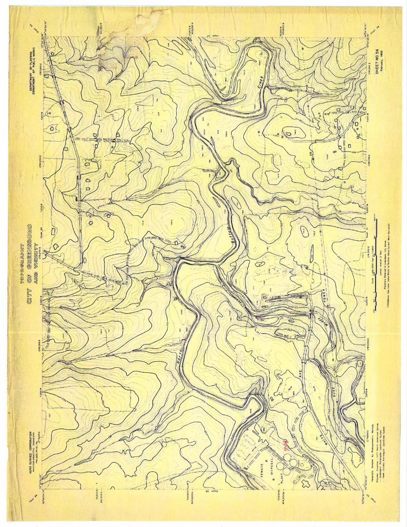
A 1955 topographic map of the City of Greensboro (2 foot contours, by Aero Service
Corporation, Photogrammetric Engineers) indicates anomalous depressions (indicated by tick
marks inside contour lines) and steep slopes (tight contour spacing) on the west and east side of
Muddy Creek (Appendix F, Supporting Documentation). The depressions are about three to four
feet deep and the steep slopes range from 20 to 40 feet high. On the east part of the Disposal
Area, a structure and the meander of the North Buffalo Creek are present.
GPS coordinates were taken of the Disposal Area perimeter. When brush and steep topography
prevented an accurate GPS coordinate from being obtained, the coordinates were taken from as
near to the visible Disposal Area perimeter as was practical. The approximate Disposal Area
perimeter is illustrated on the figures and on aerial photographs in Appendix E. A table of GPS
coordinates for the Site entrance and the Disposal Area is presented in Table 1. The Disposal
Area perimeter location is approximate and is based on visual observations made at the time of
the site visit and interpretation of aerial photographs of LiDAR images. Figures 4 and 5 show
LiDAR shaded relief superimposed on the Disposal Area.
1.6 Disposal Area Conditions
The Disposal Area was covered with kudzu, vines, briars, tall grasses, bare ground, rocks,
composted sludge, deciduous and pine trees approximately three to twelve inches in diameter,
and disposal material. The construction and demolition disposal material found to the east of the
Sewage Treatment Plant consisted of asphalt, concrete, bricks, scrap metal, and
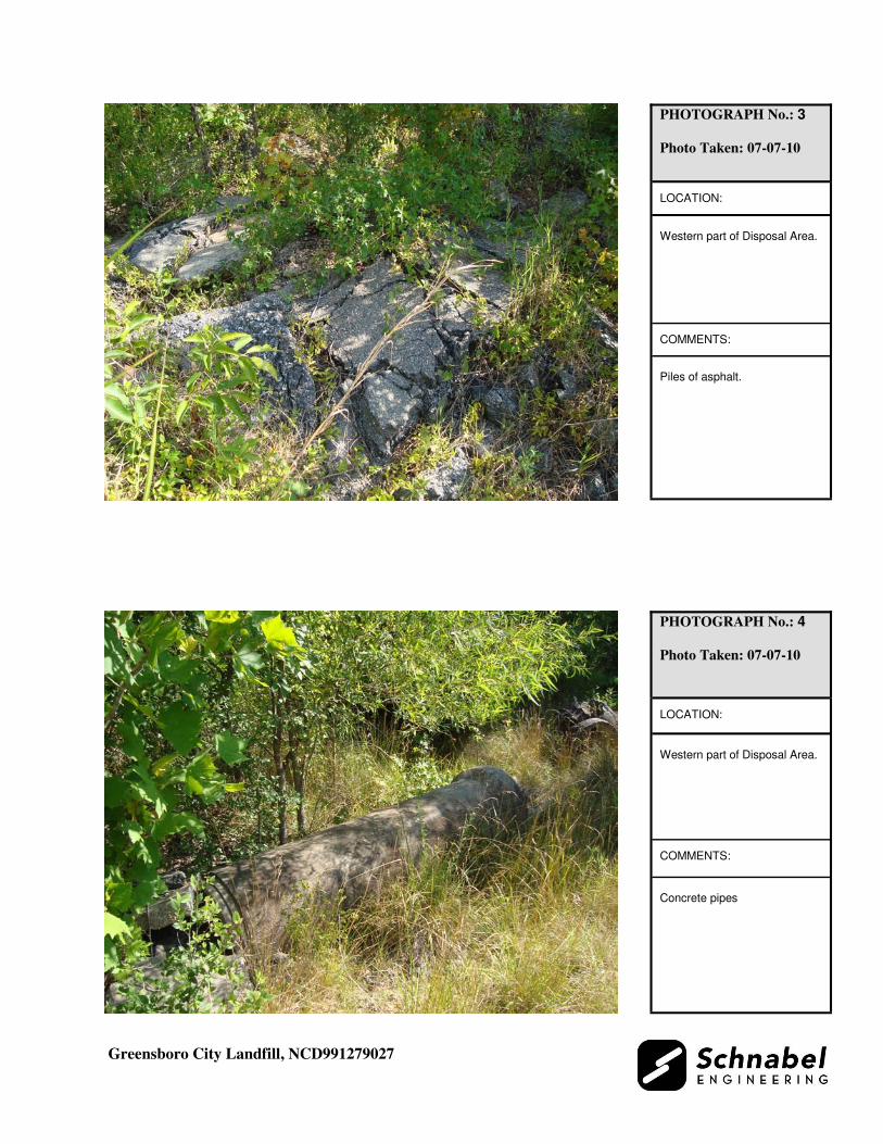
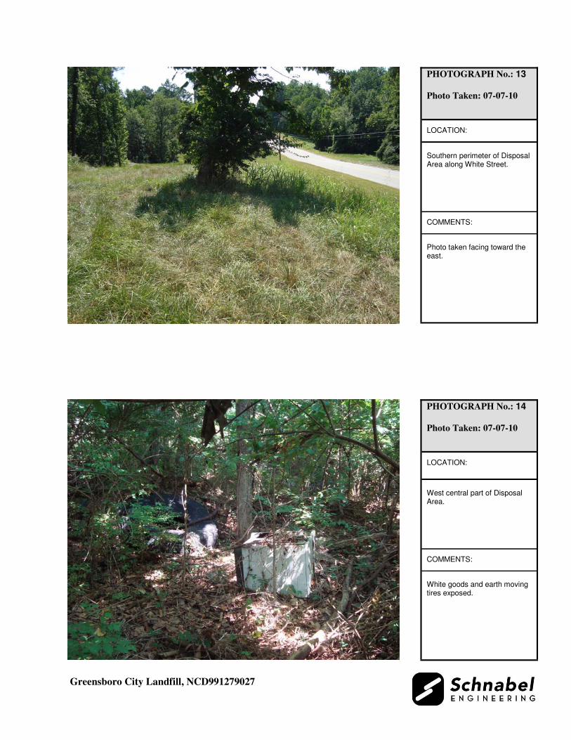
steel/concrete/plastic piping (Photos 3, 4, and 5). Heavily vegetated composted sludge was
observed near the Sewage Treatment Plant, northwest of the gravel access road into the Disposal
Area (Photo 2). Disposal material found to the east and south of the construction and demolition
material consisted of glass and plastic bottles, tires, plastics, 55-gallon drums, white goods,
vehicle parts, scrap metal, metal cans, paint cans, wood skids, tree limbs, mattresses,
miscellaneous household waste, and remnants of a concrete bridge.

Greensboro City Landfill NCD991279027
10
Approximately 40 to 50 exposed 55-gallon drums were observed on the north central part of the
Disposal Area (Photo 23). The drums were not labeled and open topped, and overturned drums
appeared empty at the time of the site visit. Examination of all drums was limited due to thick
vegetation at the time of the site visit.
Berms and steep landfill slopes were observed along the banks of Muddy Creek. Adjacent to the
banks of Muddy Creek were berms approximately three to five feet high. On the west side of
Muddy Creek a steep landfill slope approximately 10 to 30 feet high was observed
approximately 10 feet west of a berm. Disposal material, such as vehicle parts, scrap metal, tires,
white goods, and drums, were observed near the bottom of the landfill slope. Holes within the
disposal material and animal burrows were observed in the landfill slope and berm. Along the
east side of Muddy Creek, a berm approximately three to five feet high was observed along the
creek bank. Shallow landfill slopes approximately 5 to 10 feet high were observed to the east of
the sewer line/access road. Disposal material observed on these shallow slopes consisted of
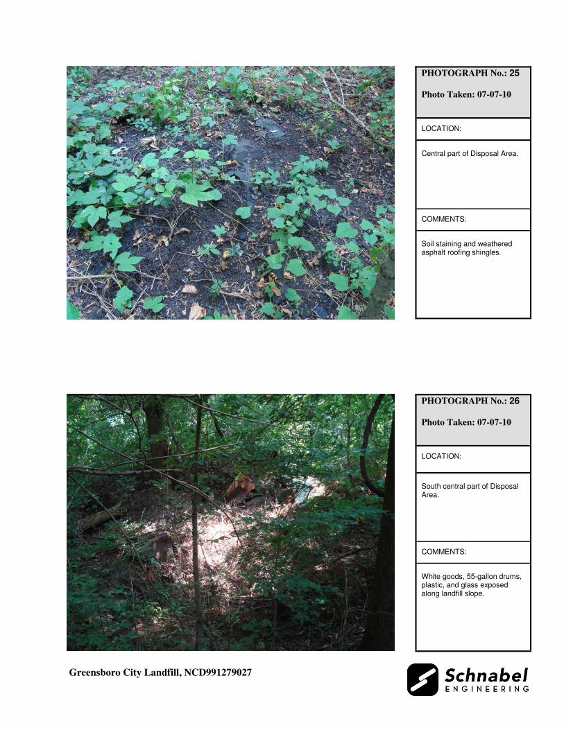
empty 55-gallon drums, white goods, miscellaneous house waste, and glass (Photo 26).
Along North Buffalo Creek, a steep 10 to 20 foot high landfill slope was observed along the
northern perimeter of the Disposal Area, on the south side bank of the creek. Scrap metal, glass
bottles, and metal cans, were observed within this landfill slope. Evidence of buried disposal
material was observed in the holes and animal burrows along the south creek bank and landfill
slope.
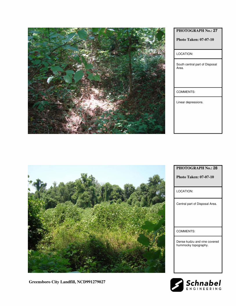
Large areas of dense kudzu and vine covered hummocky topography were observed on the
central and western parts of the Disposal Area (Photo 28). Piles of soil and rock were observed
on the southwestern part of the Disposal Area. Linear depressions were observed on the south
central part of the Disposal Area (Photo 27). Stained soil from weathered asphalt roofing
shingles was observed on the central part of the Disposal Area (Photo 25).

Greensboro City Landfill NCD991279027
11
The observed Disposal Area was on multiple tax parcels, Parcel Numbers 0079176, 0079129,
0079131, 0079130, and 0079128. The southern, western, and northern perimeters of the Disposal
Area were visually evident by landfill slopes, disposal material, North Buffalo Creek, and White
Street. The eastern and southwestern perimeters of the Disposal Area were not visually evident
due to thick vegetation cover which made it difficult to traverse. The eastern perimeter of the
Disposal Area is uncertain (dashed on Figure 2) based on the 1966 aerial photograph. The
eastern perimeter of the Greensboro City Landfill appears to extend into the White Street
Landfill property. The eastern and southwestern perimeters were identified by historical aerial
photographs, topographic maps and LiDAR images. Coordinates of points on the estimated
perimeter of the Disposal Area are listed on Table 1.
Other than described above, no notable erosion, offensive odors, or slope failures were observed
during the site visit.
1.7 Evidence of Human Activity
During the site visit, large tree stumps and berms were observed along the banks of Muddy
Creek; remnants of a concrete bridge was observed on the central part of the Disposal Area on
the eastern bank of Muddy Creek; gravel/grass roadways were observed on the western and
southern perimeters of the Disposal Area; a locked gate was near the southern perimeter of the
Disposal Area; and, sewer line with manholes was located on the central part of the Disposal
Area, east of Muddy Creek.
1.8 Potential Landfill Gas Migration Pathways
There were visible or evident potential gas migration pathways observed on the Disposal Area
and Site. Potential gas migration pathways located on the Disposal Area and Site were:
• Backfill along underground utilities: near the southern perimeter of the Disposal Area and
near the North Buffalo Creek Sewage Treatment Plant.
• Backfill along a sewer line with manholes: near the central part of the Disposal Area.

Greensboro City Landfill NCD991279027
12
• Holes in landfill slope: observed on landfill slopes near Muddy Creek and North Buffalo
Creek in the central and southern parts of the Disposal Area.
• Animal burrows: observed on berms near Muddy Creek on the central and southern parts
of the Disposal Area.
• Buildings and structures associated with the North Buffalo Creek Sewage Treatment
Plant: on the west side of the Site.
1.9 Physical Barriers
Site access is provided by a gravel/grass roadway from the east side of the North Buffalo Creek
Sewage Treatment Plant off of White Street. A second site access for vehicles is blocked by a
locked gate along the southern boundary of the Disposal Area along White Street. Steep landfill
slopes and creek banks make it difficult to access the property from Muddy Creek and North
Buffalo Creek. Dense vegetation throughout the Disposal Area is difficult to traverse.
1.10 Other Pertinent Information
Some history of the Site was obtained during conversations with persons familiar with the Site.
The information obtained indicates that:
• Ms. Jeryl Covington, Solid Waste Director for the City of Greensboro, did not know
the location of the unlined landfill, Greensboro City Landfill.
o She stated that the area of interest to the west of the White Street Landfill is
owned by the City of Greensboro and the North Buffalo Creek Sewage
Treatment Plant.
o She did not have any historical information in regards to the old unlined
landfill.
o Ms. Covington stated that the Sewage Treatment Plant used to place
construction/demolition material on their property, which was stopped by the
City of Greensboro in the early 1990s.

Greensboro City Landfill NCD991279027
13
o She stated that residences to the south of White Street are on public water.
However, residences north of the Phase II portion of the White Street Landfill,
across North Buffalo Creek, use private water wells and septic tanks.
• Mr. Nathan Osborne Jr., Water Reclamation Plant Supervisor for the City of
Greensboro, provided verbal permission to access the property to the east of the
Sewage Treatment Plant.
o He was not aware of an unlined landfill located on the property east of the
Sewage Treatment Plant.
o He did not know what materials were placed on the landfill. He stated that the
Sewage Treatment Plant stopped placing disposal materials on the property
east of the Plant in the early 1990s, ordered by the City of Greensboro.
Disposal materials consisted of concrete, asphalt, metal pipes, tree limbs, and
sludge from the centrifuge.
o He stated that disposal materials were dumped onto the property and materials
were not buried or burned on the property.
o He stated that residences near the Sewage Treatment Plant are on public water.
o Mr. Osborne did not have any historical information or contacts who may be
familiar with the unlined landfill operation.
• Mr. John Nantz, Supervisor of Health and Environmental Risk Assessment for the
Guilford County Environmental Health Department, did not know of an unlined
landfill located to the west of the White Street Landfill on the Sewage Treatment Plant
property.
o Records available from the Environmental Health Department did not pertain
to the unlined landfill on the Sewage Treatment Plant property.
o Mr. Nantz suggested contacting the Inactive Hazardous Branch of NCDENR
and the Winston-Salem Landfill group under NCDENR. He stated that Mr.
John Walsh, NCDENR in Raleigh, may have more information in regards to
the White Street Landfill.
• Mr. Lee Hill, Environmental Inspections Program Specialist for Guilford County, was
not aware of an unlined landfill west of the White Street Landfill.

Greensboro City Landfill NCD991279027
14
o He stated that the City of Greensboro owns the landfill property. He did not
have any historical information in regards to the unlined landfill.
o Mr. Hill suggested contacting Ms. Jeryl Covington, City of Greensboro Solid
Waste Director, and Mr. Hugh Jernigan of NCDENR.
• Mr. Arthur White, Engineer for Hazen and Sawyer, is retired from the City of
Greensboro. He started working at the Sewage Treatment Plant in the mid-1970s.
o He stated that the unlined landfill, Greensboro City Landfill, is located
between the Sewage Treatment Plant and the White Street Landfill. He stated
that it extends from White Street to North Buffalo Creek. Mr. White said that
the landfill might also extend to the south of the Sewage Treatment Plant,
across White Street.
o He stated that the City of Greensboro owns the landfill property. He did not
know who owned the property prior to the mid-1970s.
o He thought that the landfill closed about 10 years prior to his start at the
Sewage Treatment Plant in the mid-1970s. He did not know when the landfill
opened.
o Mr. White did not know who placed disposal material on the landfill prior to
the mid-1970s. He stated that the Sewage Treatment Plant and Water/Sewer
Department did place disposal material on top of landfill debris on the western
side of the landfill property.
o Mr. White stated he saw domestic trash, glass bottles, and old newspapers on
the old landfill. He stated that the Treatment Plant and Water/Sewer
Department placed road materials such as asphalt, concrete, gravel, pipes, soil,
backfill materials, and tree limbs on top of the old landfill debris on the
western side of the landfill. He said that the Sewage Treatment Plant also
placed composted sludge on landfill debris. He said that there was a road
connecting the western side of the landfill to the Sewage Treatment Plant
property. Materials were placed on the western side of the landfill after 1983
by the Sewage Treatment Plant and Water/Sewer Department.

Greensboro City Landfill NCD991279027
15
o He stated that the Water/Sewer Department used their trucks to dispose of the
road materials. He did not see private trucks or residences dump waste into the
landfill. He stated that local residences used to dispose of household waste into
the streams near the bridges and along the road on White Street.
o He said that recent trash debris and cut down trees and tree stumps were
noticed along the creek banks when he would take water samples from Muddy
Creek and North Buffalo Creek. He said that the City of Greensboro did cut
down large trees and remove overhanging trees along the creek banks to clear
the trees from the streams.
o He stated that the City of Greensboro planted pine tree seeds on the western
side of the landfill in order to rebuild the vegetation.
o Mr. White stated that the landfill property is not used by the Sewage Treatment
Plant or Water/Sewer Department.
o He stated that residences to the south of White Street are on public water.
o Mr. White did not have available historical records on the landfill property. He
did not know about a possible burn area on that property (as referenced by the
NCDENR Inventory Record).
• Mr. Tracy Peters, Engineering Records/Mapping for the City of Greensboro, provided
historical parcel and topographic information in regards to the unlined landfill
(Appendix F, Supporting Documentation).
o The 1955 and 1985 topographic maps did not state that a landfill was located
on the Sewage Treatment Plant property (Aero Service Corporation, 1955, and
Kucera & Associates, Inc., 1985).
o An extension of the Sewage Treatment Plant property was annexed in
December 1955, extending the Greensboro City limits to the western property
boundary of the current White Street Landfill.
Greensboro City Landfill NCD991279027
16
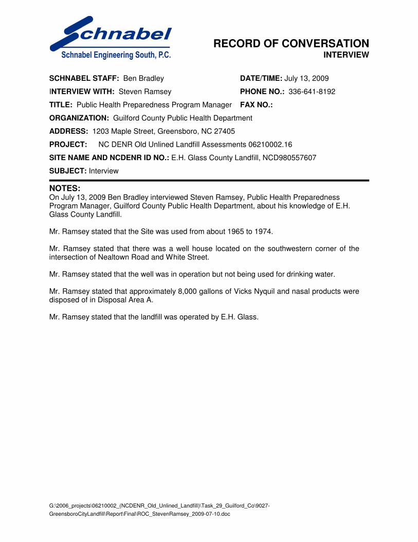
• Mr. Steven Ramsey, Public Health Preparedness Program Manager for Guilford
County Public Health Department, stated during an interview on July 13, 2009,
(Schnabel Record of Conversation for E.H. Glass County Landfill, NCD980557607)
that a well house is located on the southwestern corner of the intersection of Nealtown
Road and White Street. He said that the well was in operation but not being used for
drinking water.
Notes from conversations with people familiar with the site are included in Appendix C. The
information obtained from these conversations has not been verified or confirmed.
2.0 VICINITY CONDITIONS
This section describes the observed general conditions in the vicinity of the Site, as defined by an
area within 1,000 feet of the perimeter of the Disposal Area. Photographs illustrating vicinity
conditions are included in Appendix D.
2.1 Structures Located on Adjacent Properties
Structures described in this section are located on adjacent properties that have a shared property
boundary with the Site.
The North Buffalo Creek Sewage Treatment Plant is located adjacent to the Disposal Area to the
west on Tax Parcel 0079176. A section of the White Street Landfill is located adjacent to the east
of the Site on Tax Parcel 0083242. Residences on multiple tax parcels are located to the south of
the Disposal Area across White Street. These structures are shown on Figure 2 and on aerial
photographs in Appendix E.

Greensboro City Landfill NCD991279027
17
2.2 Water Supply Wells and Intakes
Water supply wells or well houses were not observed at residences along Nealtown Road within
a 1,000-foot radius of the Disposal Area. Water meters were observed in the yards of several of
the residences within 1,000 feet of the Site. Fire hydrants were observed within 1,000 feet of the
Site. There are no public water supply wells within 1,000 feet of the Disposal Area and Site.
According to Ms. Jeryl Covington, City of Greensboro Solid Waste Director, the area south of
Buffalo Creek is served by a public water supply. Ms. Covington stated that a few residences
north of the Phase II portion of the White Street Landfill across North Buffalo Creek are on
private wells.
One well house is located on the southwestern part of the intersection of White Street and
Nealtown Road at 1501 Nealtown Road, Greensboro, NC 27406 and owned by Ms. Joyce Scales.
Mr. Steven Ramsey, Public Health Preparedness Program Manager for Guilford County Public
Health Department, stated that the well was in operation but not being used for drinking water.
2.3 Current Land Usage
Property in the vicinity of the Site is primarily residential and wooded. Land usage at the time of
the site visit within 1,000 feet of the Disposal Area perimeter was:
North: North Buffalo Creek, wooded, residences, Greensboro Sportsplex, and Evangel Fellowship Church of God; apparent down- to up-gradient direction from the Site.
South: White Street, residential, wooded, and E.H. Glass County Landfill; apparent up-gradient direction from the Site.
East: White Street Landfill and wooded; apparent side- to down-gradient direction from the Site.
West: North Buffalo Creek Sewage Treatment Plant, wooded, and residences; apparent side- to up-gradient direction from the Site.
2.4 Surface Water Features
A pond is located adjacent to the east of the Site on the White Street Landfill property.

Greensboro City Landfill NCD991279027
18
3.0 AERIAL PHOTOGRAPHY REVIEW
Aerial photographs were reviewed for the years 1937, 1955, 1966, 1977, 1993, 2003 and 2008.
The estimated reported years of operation of the Site were from 1948 to the late 1960s.
Observations of each of the photographs are included in the following table. Copies of the aerial
photographs are included in Appendix E. Some aerial photographs are reproductions of original
aerial photographs and have some distortion; therefore, overlaid Disposal Area Boundaries and
other features may vary from their actual locations. Hand drawn lines and notations on the
photographs denote soils mapping information drawn on the original photographs by the USDA
NRCS.
Flight Year Observations Source 1937 The Disposal Area is covered with low vegetation, trees, and part of the
eastern portion has been cleared. The southwestern part of the Disposal Area, located to the south of the Sewage Treatment Plant is cleared. Roadways are visible connecting the Disposal Area to White Street and the western part of the Site that appears to be cleared for construction of the Sewage Treatment Plant. The NRCS has drawn in the North Buffalo Creek, Muddy Creek, and the unnamed perennial stream. Agricultural fields surround the Site.
1
1955 The Disposal Area appears disturbed in the western and central portions. Graded surfaces are visible on the central part of the Disposal Area. East of the unnamed perennial stream consists of low vegetation and tree cover near the meander of North Buffalo Creek. A structure is visible on the eastern part of the Disposal Area on Tax Parcel 0079131. The southwestern part of the Disposal Area, across White Street, is covered with low vegetation. The Sewage Treatment Plant is visible to the west of the Disposal Area on Site. Scattered residences are visible to the south of the Site.
1
1966 The Disposal Area is covered with low vegetation in the western and central portions. A small disturbed area in the western part of the Disposal Area is visible with linear horizontal features. The eastern part of the Disposal Area is cleared and the meander of North Buffalo Creek is no longer visible. The NRCS has labeled the Disposal Area as “6 (LANDFILL)”. The cleared land on the eastern part of the Disposal Area appears to extend into the White Street Landfill property and is labeled “6” (label is west of the pond). The pond is visible to the east of the Site on the White Street Landfill property. The property of E.H. Glass County Landfill located to the south of the Site has been labeled “6 (LANDFILL)”. A residential area is located to the south of the Site across White Street.
1
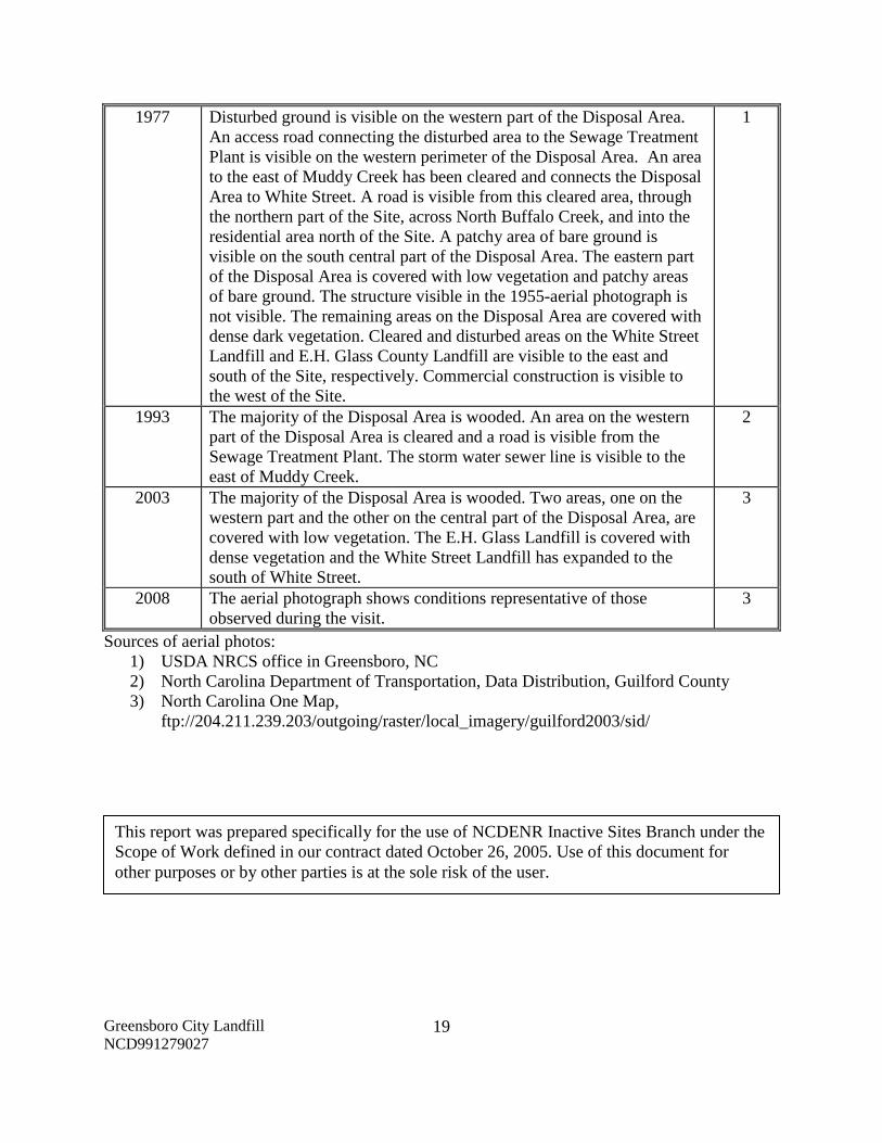
Greensboro City Landfill NCD991279027
19
1977 Disturbed ground is visible on the western part of the Disposal Area. An access road connecting the disturbed area to the Sewage Treatment Plant is visible on the western perimeter of the Disposal Area. An area to the east of Muddy Creek has been cleared and connects the Disposal Area to White Street. A road is visible from this cleared area, through the northern part of the Site, across North Buffalo Creek, and into the residential area north of the Site. A patchy area of bare ground is visible on the south central part of the Disposal Area. The eastern part of the Disposal Area is covered with low vegetation and patchy areas of bare ground. The structure visible in the 1955-aerial photograph is not visible. The remaining areas on the Disposal Area are covered with dense dark vegetation. Cleared and disturbed areas on the White Street Landfill and E.H. Glass County Landfill are visible to the east and south of the Site, respectively. Commercial construction is visible to the west of the Site.
1
1993 The majority of the Disposal Area is wooded. An area on the western part of the Disposal Area is cleared and a road is visible from the Sewage Treatment Plant. The storm water sewer line is visible to the east of Muddy Creek.
2
2003 The majority of the Disposal Area is wooded. Two areas, one on the western part and the other on the central part of the Disposal Area, are covered with low vegetation. The E.H. Glass Landfill is covered with dense vegetation and the White Street Landfill has expanded to the south of White Street.
3
2008 The aerial photograph shows conditions representative of those observed during the visit.
3
Sources of aerial photos: 1) USDA NRCS office in Greensboro, NC 2) North Carolina Department of Transportation, Data Distribution, Guilford County 3) North Carolina One Map,
ftp://204.211.239.203/outgoing/raster/local_imagery/guilford2003/sid/
This report was prepared specifically for the use of NCDENR Inactive Sites Branch under the Scope of Work defined in our contract dated October 26, 2005. Use of this document for other purposes or by other parties is at the sole risk of the user.

TABLE

TABLE 1
Tabulated GPS Coordinates
Point
State Plane Coordinates
(meters)
Latitude
(deg, min, sec)
Longitude
(deg, min, sec)
Northing Easting N W
Site Entrance 1 261977 542461 36 6 33.4 79 44 44.5
Site Entrance 2 261783 542713 36 6 27.1 79 44 34.4
P-1 261845 543548 36 6 29.3 79 44 1.0
P-2 261809 543404 36 6 28.1 79 44 6.8
P-3 261758 542877 36 6 26.4 79 44 27.8
P-4 261808 542491 36 6 27.9 79 44 43.2
P-5 262059 543072 36 6 36.2 79 44 20.1
P-6 262070 543092 36 6 36.5 79 44 19.3
P-7 262020 543142 36 6 34.9 79 44 17.3
P-8 262043 543202 36 6 35.7 79 44 14.9
P-9 262125 543285 36 6 38.4 79 44 11.6
P-10 262120 543315 36 6 38.2 79 44 10.4
P-11 262026 543374 36 6 35.2 79 44 8.0
P-12 262004 543398 36 6 34.5 79 44 7.0
P-13 261974 543492 36 6 33.5 79 44 3.3
P-14 261949 543552 36 6 32.7 79 44 0.9
P-15 261801 542440 36 6 27.7 79 44 45.3
P-16 261844 542390 36 6 29.0 79 44 47.3
P-17 261881 542374 36 6 30.2 79 44 48.0
P-18 261930 542407 36 6 31.8 79 44 46.7
P-19 262009 542480 36 6 34.4 79 44 43.8
P-20 262050 542549 36 6 35.8 79 44 41.0
P-21 262065 542665 36 6 36.3 79 44 36.4
P-22 262046 542685 36 6 35.7 79 44 35.6
P-23 262030 542844 36 6 35.2 79 44 29.2
P-24 261980 542892 36 6 33.6 79 44 27.3
P-25 262028 543044 36 6 35.2 79 44 21.2
P-26 261778 542418 36 6 26.9 79 44 46.1
P-27 261693 542255 36 6 24.1 79 44 52.7
P-28 261681 542262 36 6 23.7 79 44 52.4
P-29 261691 542488 36 6 24.1 79 44 43.3
P-30 261724 542530 36 6 25.2 79 44 41.7
P-31 261724 542556 36 6 25.2 79 44 40.6
P-32 261698 542589 36 6 24.3 79 44 39.3
P-33 261717 542646 36 6 25.0 79 44 37.0
P-34 261749 542659 36 6 26.0 79 44 36.5
P-35 261789 542656 36 6 27.3 79 44 36.6
Notes:
1) Points obtained during site visit using a WAAS enabled Garmin GPSMap60CS, and
based on interpretation of aerial photographs, and property boundaries.
2) All points in NAD83 datum.

FIGURES

White St
Summit Ave
Penry Rd
Ball S
t
Spry St
Phillips Ave
Nealtown Rd
16th
St
Huff St
Ohen
ry Blv
d
Hines Chapel Rd
Wendover Ave
Larchmont Dr
Irwin
St
Mc Knig
ht Mill R
d
Holt A
ve
Martin A
ve
Bywo
od R
d
Ryan St
Wilcox Dr
Larkspur Dr
Mille
r Dr
Cone Blvd
Willa
rd St
Oran
ge S
t
Sand
s Dr
Tuck
er St
Textile Dr
Woodnell St
Drex
el Rd
Wood
briar
Ave
Gatew
ood A
veAu
tumn D
r
Rank
in Mi
ll Rd
Brame Rd
Huffin
e Mill
Rd
Elmer
St
Burlington Rd
Sharon
Ave
Wolf Rd
Lord Foxley DrMi
norw
ood R
d
Trent St
Tiller
y Dr
Cecilside LnWhitman Rd
Emerson Rd
Joyce St
Hern
Ave
Sprin
g St Nichols Ave
Utah Pl
Kildare Dr
Wichita Pl
Engli
sh S
t
Elwell
Ave
Lynn Rd
Waug
h St
Queen Beth DrAshle
y Dr
Parn
ell D
r
Armh
urst
Rd
Belfield
Dr
Springmont DrFarrell St
Taylorcrest Rd
Sharo
nbroo
k Dr
Barto
Pl
Mc Ph
erson
StWo
odme
re Dr
Joe Brown DrMarkham Rd
Coun
try R
idge R
d
Tillman Ave
Twain RdGa
tesvil
le Rd
Anderson St
Enoch Ln
Kentwood St
Builtw
ell R
d
11th St
Crite Ct
Alco
tt Rd
Easto
n Rd
Redwood Dr
16th Ct
Loch Pl
Sir Galahad Rd
Chesire Way
Parker St
King
ston R
dWater St
Asso
ciate
Dr
Ralei
gh S
tOl
a St
Saint Charles Ln
Peterson Ave
10th St
Redo
r St
Alonzo Ct
Sykes Ave
Fairbrother St
Rankin Rd
Northgate Dr
Byron Pl
Granbury Dr
Canton Ave
Belden Dr
Bash
ford L
n
White
Elde
r Rd
Patio Pl
Esquire Ct
Summit Ave
White St
Joyc
e St
Burlington Rd
Sands Dr
Syke
s Ave
Huffine Mill Rd
Tucker St
Mc Knight Mill Rd
Cone Blvd
Kildare Dr
Figure 1
USGS TOPOGRAPHIC MAPNCDENR
OLD LANDFILL ASSESSMENT
Source:1:24,000
Greensboro City Landfill NCD991279027Guilford County, NC
2,000 0 2,0001,000Feet
Scale:
F
(approx.)
1. USGS 7.5' Quadrangle, McLeansville NC, 1952 Topography Based on Aerial Photos Taken 1971 Photorevised 1968, Contour Intervals = 10 ft
Disposal AreaSite Property LinesPerimeter Uncertain
500 ft
1000 ft


APPENDIX A
FIELD RECONNAISSANCE SHEET


APPENDIX B
TAX RECORDS

Guilford County, NC
Old Parcel Number 000301420052900003 Condo Book
Parcel Number 0079176 Condo Page
PIN 7885091468 Total Assessed Value $0
Owner Name CITY OF GREENSBORO Total Building Value $100
Mailing Address 1 PO BOX 3136Total Out Building Value
$0
Mailing Address City
GREENSBORO Total Land Value $1,943,600
Mailing Address State
NC Total Deferred Value $0
Mailing Address Zip
27402 Building Count 1
Property Address 2199 WHITE ST Building Number 1
Legal Desc 1Lot # 92.55 AC NORTH BUFFALO TREATMENT
Year Built 1981
Land Units 92.5500 Heated Area 1
Deed Book 001849 Bedrooms 0
Deed Page 00431 Bathrooms FULL:0 HALF: 0
Plat Book Use CodeGOVERNMENT OWNED
Page 1 of 2Print Preview
7/26/2010http://gcgis.co.guilford.nc.us/guilford_new/printPreview.aspx?PrintOptData=Guilford Cou...

Plat Page Appraisal Model Code
OTHERMUNICP
Disclaimer: While every effort is made to keep information provided over the internet accurate and up-to-date, Guilford County does not certify the authenticity or accuracy of such information. No warranties, express or implied, are provided for the records and/or
mapping data herein, or for their use or interpretation by the User.
Map Scale 1 inch = 758 feet
Page 2 of 2Print Preview
7/26/2010http://gcgis.co.guilford.nc.us/guilford_new/printPreview.aspx?PrintOptData=Guilford Cou...

Guilford County, NC
Old Parcel Number 000301420050200039 Condo Book
Parcel Number 0079130 Condo Page
PIN 7885298186Total Assessed Value
$0
Owner Name CITY OF GREENSBORO Total Building Value $0
Mailing Address 1 PO BOX 3136Total Out Building Value
$0
Mailing Address City
GREENSBORO Total Land Value $192,800
Mailing Address State
NC Total Deferred Value $0
Mailing Address Zip
27402 Building Count
Property Address 2010 2012 WHITE ST Building Number
Legal Desc 1Lot # 10.71 AC MINOR ANNEXED CITY FOR 1988
Year Built
Land Units 10.7100 Heated Area
Deed Book 001557 Bedrooms
Deed Page 00431 Bathrooms
Plat Book Use Code GOVERNMENT
Page 1 of 2Print Preview
7/26/2010http://gcgis.co.guilford.nc.us/guilford_new/printPreview.aspx?PrintOptData=Guilford Cou...

OWNED
Plat Page Appraisal Model Code
Disclaimer: While every effort is made to keep information provided over the internet accurate and up-to-date, Guilford County does not certify the authenticity or accuracy of such information. No warranties, express or implied, are provided for the records and/or
mapping data herein, or for their use or interpretation by the User.
Map Scale 1 inch = 800 feet
Page 2 of 2Print Preview
7/26/2010http://gcgis.co.guilford.nc.us/guilford_new/printPreview.aspx?PrintOptData=Guilford Cou...

Guilford County, NC
Old Parcel Number 000301420050200040 Condo Book
Parcel Number 0079131 Condo Page
PIN 7885292130 Total Assessed Value $0
Owner Name CITY OF GREENSBORO Total Building Value $0
Mailing Address 1 PO BOX 3136 Total Out Building Value $0
Mailing Address City GREENSBORO Total Land Value $173,500
Mailing Address State NC Total Deferred Value $0
Mailing Address Zip 27402 Building Count
Property Address 2006 2008 WHITE ST Building Number
Legal Desc 1 Lot # 7.71 AC NEAL Year Built
Land Units 7.7100 Heated Area
Deed Book Bedrooms
Deed Page Bathrooms
Plat Book Use Code GOVERNMENT OWNED
Plat Page Appraisal Model Code
Disclaimer: While every effort is made to keep information provided over the internet accurate and up-to-date, Guilford County does not certify the authenticity or accuracy of such information. No warranties, express or implied, are provided for the records and/or
mapping data herein, or for their use or interpretation by the User.
Map Scale 1 inch = 835 feet
Page 1 of 1Print Preview
7/26/2010http://gcgis.co.guilford.nc.us/guilford_new/printPreview.aspx?PrintOptData=Guilford Cou...

Guilford County, NC
Old Parcel Number 000301420050200038 Condo Book
Parcel Number 0079129 Condo Page
PIN 7885197028 Total Assessed Value $0
Owner Name CITY OF GREENSBORO Total Building Value $0
Mailing Address 1 PO BOX 3136 Total Out Building Value $0
Mailing Address City GREENSBORO Total Land Value $141,900
Mailing Address State NC Total Deferred Value $0
Mailing Address Zip 27402 Building Count
Property Address 2002 2004 WHITE ST Building Number
Legal Desc 1 Lot # 7.57 AC MINOR Year Built
Land Units 7.5700 Heated Area
Deed Book 000350 Bedrooms
Deed Page 00918 Bathrooms
Plat Book Use Code GOVERNMENT OWNED
Plat Page Appraisal Model Code
Disclaimer: While every effort is made to keep information provided over the internet accurate and up-to-date, Guilford County does not certify the authenticity or accuracy of such information. No warranties, express or implied, are provided for the records and/or
mapping data herein, or for their use or interpretation by the User.
Map Scale 1 inch = 820 feet
Page 1 of 1Print Preview
7/26/2010http://gcgis.co.guilford.nc.us/guilford_new/printPreview.aspx?PrintOptData=Guilford Cou...

Guilford County, NC
Old Parcel Number
000301420050200016 Condo Book
Parcel Number 0079128 Condo Page
PIN 7885296575Total Assessed Value
$0
Owner Name CITY OF GREENSBORO Total Building Value $0
Mailing Address 1 PO BOX 3136Total Out Building Value
$0
Mailing Address City
GREENSBORO Total Land Value $179,000
Mailing Address State
NC Total Deferred Value $0
Mailing Address Zip
27402 Building Count
Property Address 2012 R1 WHITE ST Building Number
Legal Desc 1Lot # 11.93 AC DONNELL ANNEXED CITY FOR 1988
Year Built
Land Units 11.9300 Heated Area
Deed Book 000350 Bedrooms
Deed Page 00917 Bathrooms
Page 1 of 2Print Preview
7/26/2010http://gcgis.co.guilford.nc.us/guilford_new/printPreview.aspx?PrintOptData=Guilford Cou...

Plat Book Use CodeGOVERNMENT OWNED
Plat Page Appraisal Model Code
Disclaimer: While every effort is made to keep information provided over the internet accurate and up-to-date, Guilford County does not certify the authenticity or accuracy of such information. No warranties, express or implied, are provided for the records and/or
mapping data herein, or for their use or interpretation by the User.
Map Scale 1 inch = 800 feet
Page 2 of 2Print Preview
7/26/2010http://gcgis.co.guilford.nc.us/guilford_new/printPreview.aspx?PrintOptData=Guilford Cou...

APPENDIX C
RECORDS OF COMMUNICATION
SITE VISIT PERMISSION LETTER


G:\2006_projects\06210002_(NCDENR_Old_Unlined_Landfill)\Task_29_Guilford_Co\9027-
GreensboroCityLandfill\Report\Final\ROC_StevenRamsey_2009-07-10.doc
RECORD OF CONVERSATION
INTERVIEW
SCHNABEL STAFF: Ben Bradley DATE/TIME: July 13, 2009
INTERVIEW WITH: Steven Ramsey PHONE NO.: 336-641-8192
TITLE: Public Health Preparedness Program Manager FAX NO.:
ORGANIZATION: Guilford County Public Health Department
ADDRESS: 1203 Maple Street, Greensboro, NC 27405
PROJECT: NC DENR Old Unlined Landfill Assessments 06210002.16
SITE NAME AND NCDENR ID NO.: E.H. Glass County Landfill, NCD980557607
SUBJECT: Interview
NOTES: On July 13, 2009 Ben Bradley interviewed Steven Ramsey, Public Health Preparedness Program Manager, Guilford County Public Health Department, about his knowledge of E.H. Glass County Landfill. Mr. Ramsey stated that the Site was used from about 1965 to 1974. Mr. Ramsey stated that there was a well house located on the southwestern corner of the intersection of Nealtown Road and White Street. Mr. Ramsey stated that the well was in operation but not being used for drinking water. Mr. Ramsey stated that approximately 8,000 gallons of Vicks Nyquil and nasal products were disposed of in Disposal Area A. Mr. Ramsey stated that the landfill was operated by E.H. Glass.

CONVERSATION RECORD
CONTACT:
TITLE:
Nathan Osborne, Jr.
Water Reclamation Plant
Supervisor
ORGANIZATION: City of Greensboro
Water Resources Department
ADDRESS: 2199 White Street
Greensboro, NC 27405
DATE:
TIME:
July 7, 2010
10:00am
PHONE: 336-373-7850 FAX: 336-373-7585
PROJECT NAME: NC DENR Old Unlined Landfill
Assessment
PROJECT NO.: 06210002.29
SITE NAME: Greensboro City Landfill NC DENR ID NO.: NCD991279027
SUBJECT: Interview – Site Access Permission
SCHNABEL REP: Sue Mickiewicz
INCOMING
CALL OUTGOING
CALL MESSAGE LEFT FOR
CONTACT MESSAGE
RECEIVED MEETING
REASON FOR INTERVIEW: Mr. Osborne is the site contact for the North Buffalo Creek Sewage Treatment Plant.
PERMISSON GRANTED TO ACCESS PROPERTY: Mr. Osborne gave verbal permission to walk on the property
east of the Sewage Treatment Plant. The NCDENR Property Owner Letter was provided to Mr. Osborne on July
7th during the interview meeting.
LOCATION OF LANDFILL: Mr. Osborne stated that he did not know of an unlined landfill on the property owned
by City of Greensboro.
WHO OWNS THE LANDFILL PROPERTY: The City of Greensboro owns the landfill property.
LIMITS OF LANDFILL: Mr. Osborne was not familiar with the limits of the landfill.
LANDFILL OPERATION DATES: Mr. Osborne was not familiar with the landfill operation dates. But, stated that
the Sewage Treatment Plant stopped placing construction/demolition material on Site in the 1990’s.
WHO PLACED WASTE IN LANDFILL: The Sewage Treatment Plant placed construction/demolition material, tree
limbs, and sludge on the Site until the early 1990’s.
MATERIALS PLACED IN LANDFILL: Mr. Osborne stated that the Sewage Treatment Plant used to place
concrete, asphalt, metal pipes, tree limbs, and sludge from the centrifuge were placed to the east of the
Treatment Plant. The placement of construction/demolition material, tree limbs and sludge was stopped in the
early 1990’s by the City of Greensboro.
HOW WAS MATERIAL PLACED IN LANDFILL: Mr. Osborne stated that the construction/demolition material, tree
limbs and sludge were dumped onto the Site. He stated that nothing was buried or burned on the property.
WAS MATERIAL PLACED AFTER JANUARY 1, 1983: Yes, the Treatment Plant placed material on Site until the
early 1990’s.
AVAILABLE RECORDS: Mr. Osborne did not have any available records. PRESENT AND PRIOR LAND USE: The Site is not used. PUBLIC OR PRIVATE WATER SUPPLY: Public water.
11A Oak Branch Drive Greensboro, NC 27407
T/ 336-274-9456 F/ 336-274-9486

Greensboro City Landfill NCD991279027/ July 7, 2010 Page 2 Schnabel Engineering
ADDITIONAL INFORMATION: Mr. Osborne stated that during a hurricane, North Buffalo Creek nearly flooded onto the Treatment Plant property. Therefore, a concrete wall and fence was built along the northern and eastern boundaries of the property shortly after in case of another possible flood. OTHER CONTACTS: Mr. Osborne did not have any other contacts who may have information about the unlined landfill. G:\2006_projects\06210002_(NCDENR_Old_Unlined_Landfill)\Task_29_Guilford_Co\9027-GreensboroCityLandfill\Report\Final\ROC_NathanOsborne_2010-07-07.docx

CONVERSATION RECORD CONTACT: TITLE:
Jeryl Covington Solid Waste Director
ORGANIZATION: City of Greensboro
ADDRESS: P.O. Box 3136 300 West Washington Street Greensboro, NC 27402
DATE: TIME:
July 7, 2010 8:30pm Revised September 20, 2010
PHONE: 336-373-2443 FAX: PROJECT NAME: NC DENR Old Unlined Landfill
Assessment PROJECT NO.: 06210002.29
SITE NAME: Greensboro City Landfill NC DENR ID NO.: NCD991279027 SUBJECT: Interview SCHNABEL REP: Sue Mickiewicz
INCOMING CALL OUTGOING
CALL MESSAGE LEFT FOR CONTACT MESSAGE
RECEIVED MEETING
REASON FOR INTERVIEW: Ms. Covington is the Solid Waste Director for the City of Greensboro and property contact for the White Street Landfill. PERMISSON GRANTED TO ACCESS PROPERTY: Ms. Covington provided verbal permission to access the White Street Landfill. LOCATION OF LANDFILL: Ms. Covington did not know. WHO OWNS THE LANDFILL PROPERTY: Ms. Covington stated that the City of Greensboro owns the property that the North Buffalo Creek Sewage Treatment Plant is located and stated that we would need to ask the personnel at the Treatment Plant for permission to walk on the property to the west of the White Street Landfill. LIMITS OF LANDFILL: Ms. Covington did not know. LANDFILL OPERATION DATES: Ms. Covington did not know. WHO PLACED WASTE IN LANDFILL: Ms. Covington did not know. MATERIALS PLACED IN LANDFILL: Ms. Covington did not know. She stated that the Sewage Treatment Plant used to place construction/demolition material at that property (east of the Treatment Plant) and the City of Greensboro stopped that activity in the early 1990’s. HOW WAS MATERIAL PLACED IN LANDFILL: Ms. Covington did not know. WAS MATERIAL PLACED AFTER JANUARY 1, 1983: Ms. Covington stated that the City of Greensboro stopped the Sewage Treatment Plant from placing construction/demolition material on the Site in the early 1990’s. AVAILABLE RECORDS: Ms. Covington did not have records in regards to the property to the east of the White Street Landfill. PRESENT AND PRIOR LAND USE: Ms. Covington stated that the property is no longer in use.
11A Oak Branch Drive Greensboro, NC 27407
T/ 336-274-9456 F/ 336-274-9486

Greensboro City Landfill NCD991279027/ July 1, 2010 Page 2 Schnabel Engineering
PUBLIC OR PRIVATE WATER SUPPLY: Ms. Covington stated that residences are on public water near this Site; however, residences north of the Phase II portion of the White Street Landfill, across from North Buffalo Creek, use private water wells and septic tanks. OTHER CONTACTS: ADDITIONAL INFORMATION: Ms. Covington did not have any more additional information. G:\2006_projects\06210002_(NCDENR_Old_Unlined_Landfill)\Task_29_Guilford_Co\9027-GreensboroCityLandfill\Report\Final\ROC_JerylCovington_2010-07-07_Revised.docx

CONVERSATION RECORD
CONTACT:
TITLE:
John Nantz
Supervisor of Health and
Environmental Risk Assessment
ORGANIZATION: Guilford County Environmental
Health Department
ADDRESS: 400 W. Market Street, Suite 300
Greensboro, NC 27401
DATE:
TIME:
July 16, 2010
9:00am
PHONE: 336-641-4746 FAX: 336-641-3730
PROJECT NAME: NC DENR Old Unlined Landfill
Assessment
PROJECT NO.: 06210002.29
SITE NAME: Greensboro City Landfill NC DENR ID NO.: NCD991279027
SUBJECT: Interview, Records for White Street Landfill
SCHNABEL REP: Sue Mickiewicz
INCOMING
CALL OUTGOING
CALL MESSAGE LEFT FOR
CONTACT MESSAGE
RECEIVED MEETING
REASON FOR INTERVIEW: Mr. Nantz stated that he may have available records for the White Street Landfill
(Greensboro City Landfill).
PERMISSON GRANTED TO ACCESS PROPERTY: Not applicable.
LOCATION OF LANDFILL: Mr. Nantz was aware of the location of the White Street Landfill. Mr. Nantz did not
know of a landfill located to the west of the White Street Landfill on the North Buffalo Creek Sewage Treatment
Plant property.
WHO OWNS THE LANDFILL PROPERTY: Did not know.
LIMITS OF LANDFILL: Did not know.
LANDFILL OPERATION DATES: Did not know.
WHO PLACED WASTE IN LANDFILL: Did not know.
MATERIALS PLACED IN LANDFILL: Did not know.
HOW WAS MATERIAL PLACED IN LANDFILL: Did not know.
WAS MATERIAL PLACED AFTER JANUARY 1, 1983: Did not know.
AVAILABLE RECORDS: Mr. Nantz had records available for review in regards to the White Street Landfill. The
records pertained to an underground storage tank (heating oil tank) pull with contaminated soil and air permits for
the White Street Landfill. These records did not pertain to the area on the Sewage Treatment Plant property.
PRESENT AND PRIOR LAND USE: Not applicable.
PUBLIC OR PRIVATE WATER SUPPLY: Not applicable.
OTHER CONTACTS: Mr. Nantz suggested contacting the Inactive Hazardous Branch of NCDENR and the
Winston-Salem Landfill group under NCDENR. He stated that Mr. John Walsh, NCDENR in Raleigh, may have
more information in regards to the White Street Landfill.
ADDITIONAL INFORMATION: Mr. Nantz did not have any other available records in regard to the unlined landfill
located on the Sewage Treatment Plant property.
G:\2006_projects\06210002_(NCDENR_Old_Unlined_Landfill)\Task_29_Guilford_Co\9027-GreensboroCityLandfill\Report\Final\ROC_JohnNantz_2010-07-16.docx
11A Oak Branch Drive Greensboro, NC 27407
T/ 336-274-9456 F/ 336-274-9486

CONVERSATION RECORD
CONTACT:
TITLE:
Lee Hill
Environmental Inspections
Program Specialist
ORGANIZATION: Solid Waste Enforcement,
Guilford County
ADDRESS: 400 West Market Street
P.O. Box 3427
Greensboro, NC 27402
DATE:
TIME:
July 27, 2010
2:30pm
PHONE: 336-641-2082 FAX:
PROJECT NAME: NC DENR Old Unlined Landfill
Assessment
PROJECT NO.: 06210002.29
SITE NAME: Greensboro City Landfill NC DENR ID NO.: NCD991279027
SUBJECT: Interview
SCHNABEL REP: Sue Mickiewicz
INCOMING
CALL OUTGOING
CALL MESSAGE LEFT FOR
CONTACT MESSAGE
RECEIVED MEETING
REASON FOR INTERVIEW: Mr. Hill was contacted to determine if the County had any historical information on
the Greensboro City Landfill.
PERMISSON GRANTED TO ACCESS PROPERTY: Not Applicable.
LOCATION OF LANDFILL: Mr. Hill did not know.
WHO OWNS THE LANDFILL PROPERTY: Mr. Hill stated that the City of Greensboro owns the landfill and stated
that I should contact Ms. Jeryl Covington, Solid Waste Director for the City of Greensboro.
LIMITS OF LANDFILL: Mr. Hill did not know.
LANDFILL OPERATION DATES: Not Applicable.
WHO PLACED WASTE IN LANDFILL: Not Applicable.
MATERIALS PLACED IN LANDFILL: Not Applicable.
HOW WAS MATERIAL PLACED IN LANDFILL: Not Applicable.
WAS MATERIAL PLACED AFTER JANUARY 1, 1983: Not Applicable.
AVAILABLE RECORDS: Mr. Hill stated that he did not have records on hand for the Greensboro City Landfill.
PRESENT AND PRIOR LAND USE: Not Applicable.
PUBLIC OR PRIVATE WATER SUPPLY: Not Applicable.
OTHER CONTACTS: Mr. Hill stated that Mr. Hugh Jernigan of NCDENR would have information in regards to this property on the Greensboro City Landfill. ADDITIONAL INFORMATION: Mr. Hill did not know any historical information about this Site.
G:\2006_projects\06210002_(NCDENR_Old_Unlined_Landfill)\Task_29_Guilford_Co\9027-GreensboroCityLandfill\Report\Final\ROC_LeeHill_2010-07-27.docx
11A Oak Branch Drive Greensboro, NC 27407
T/ 336-274-9456 F/ 336-274-9486

Greensboro City Landfill NCD991279027/ July 1, 2010 Page 2 Schnabel Engineering
OTHER CONTACTS: Ms. Covington suggested contacting Mr. Dexter Matthews, Mr. James Coffey, and Ms.
Charlotte Jesnick of the Division of Waste Management for more historical information in regards to this Site.
ADDITIONAL INFORMATION: Ms. Covington did not have any more additional information.
G:\2006_projects\06210002_(NCDENR_Old_Unlined_Landfill)\Task_29_Guilford_Co\9027-GreensboroCityLandfill\Report\Final\ROC_JerylCovington_2010-07-01.docx

CONVERSATION RECORD
CONTACT:
TITLE:
Arthur White
Engineer
ORGANIZATION: Hazen and Sawyer
ADDRESS: 629 Green Valley Road
Greensboro, NC 27408-7726
DATE:
TIME:
July 27, 2010
4:00pm
PHONE: 336-292-7490 (office)
336-549-7836 (cell)
FAX:
PROJECT NAME: NC DENR Old Unlined Landfill
Assessment
PROJECT NO.: 06210002.29
SITE NAME: Greensboro City Landfill NC DENR ID NO.: NCD991279027
SUBJECT: Interview
SCHNABEL REP: Sue Mickiewicz
INCOMING
CALL OUTGOING
CALL MESSAGE LEFT FOR
CONTACT MESSAGE
RECEIVED MEETING
REASON FOR INTERVIEW: Mr. White was recommended as a contact from Mr. Allan Williams, City of
Greensboro Director of Water Resources. Mr. White retired from working for the City of Greensboro about 5 years
ago and now works part-time for Hazen and Sawyer. Mr. White started working at the North Buffalo Creek
Sewage Treatment Plant by the mid-1970s.
PERMISSON GRANTED TO ACCESS PROPERTY: Not applicable.
LOCATION OF LANDFILL: Mr. White stated that the landfill was located between the Sewage Treatment Plant
and the White Street Landfill.
WHO OWNS THE LANDFILL PROPERTY: Mr. White stated that the landfill property is owned by the City. He
stated that the landfill closed about 10 years before he started working at the Treatment Plant in the mid-1970s.
He did not know who owned the property before the mid-1970s.
LIMITS OF LANDFILL: He stated that the landfill was located between the Treatment Plant and White Street
Landfill. He stated that it extended from White Street to North Buffalo Creek. He did not know the depth of waste
because it was very over grown in the mid-1970s and he stated that backfill material was placed on top of the old
landfill.
LANDFILL OPERATION DATES: He did not know when the landfill started operation. He stated it closed about 10
years prior to when he started at the Treatment Plant. He stated that the overgrowth and trees along White Street
were at least 10 years old or older by the mid-1970s.
WHO PLACED WASTE IN LANDFILL: Mr. White stated that he did not know who placed waste at the landfill
before the mid-1970s. He stated that the Sewage Treatment Plant and Water/Sewer Department did place
disposal material on top of landfill debris on the western side of the landfill property.
11A Oak Branch Drive Greensboro, NC 27407
T/ 336-274-9456 F/ 336-274-9486

Greensboro City Landfill NCD991279027/
July 27, 2010 Page 2 Schnabel Engineering
MATERIALS PLACED IN LANDFILL: Mr. White stated he saw domestic trash, glass bottles, and old newspapers
on the old landfill. He said that people did not walk through that area to determine the extent of the landfill
because packs of wild dogs were rumored to be living in that area. He stated that the Treatment Plant and
Water/Sewer Department placed road materials such as asphalt, concrete, gravel, pipes, soil, backfill materials,
and tree limbs on top of the old landfill debris on the western side of the landfill. He said that the Sewage
Treatment Plant also placed composted sludge on old landfill debris. He said that there was a road connecting the
western side of the landfill to the Sewage Treatment Plant property.
HOW WAS MATERIAL PLACED IN LANDFILL: He stated that the Water/Sewer Department used their trucks to
dispose of the road materials. He did not see private trucks or residences dump waste into the landfill. He stated
that local residences used to dispose of household waste into the streams near the bridges and along the road on
White Street.
WAS MATERIAL PLACED AFTER JANUARY 1, 1983: Materials were placed on the western side of the landfill
after 1983 by the Sewage Treatment Plant and Water/Sewer Department. The old landfill was not in operation
after 1983.
AVAILABLE RECORDS: Mr. White did not have available historical records on the landfill property.
PRESENT AND PRIOR LAND USE: Mr. White stated that the landfill property is not in use by the Sewage
Treatment Plant or Water/Sewer Department.
PUBLIC OR PRIVATE WATER SUPPLY: Mr. White stated that residences south of White Street are on public
water.
OTHER CONTACTS: Mr. White did not have any other contacts.
ADDITIONAL INFORMATION:
1) He said that recent trash debris and cut down trees and tree stumps were noticed along the creek banks
when he would take water samples from Muddy Creek and North Buffalo Creek. He said that the City of
Greensboro did cut down large trees and remove overhanging trees along the creek banks to clear the
trees from the streams.
2) He stated that the City planted pine tree seeds on the western side of the landfill in order to rebuild the
vegetation.
3) Mr. White did not know about a possible burn area on that property (as referenced by the NCDENR
Inventory Record).
4) Mr. White stated that landfill debris might have been placed across the street from the old landfill, to the
south of the Sewage Treatment Plant. He stated that while he was working at the Sewage Treatment
Plant, residential developers wanted to buy that land and continue residential development westward
along White Street. He stated that he refused to have the City of Greensboro sell that land because
residences should not be located so close to a Sewage Treatment Plant and it was possible that landfill
debris was also dumped on that property.
G:\2006_projects\06210002_(NCDENR_Old_Unlined_Landfill)\Task_29_Guilford_Co\9027-GreensboroCityLandfill\Report\Final\ROC_ArthurWhite_2010-07-27.docx

CONVERSATION RECORD
CONTACT:
TITLE:
Tracy N. Peters, III
Engineering Records/Mapping
ORGANIZATION: City of Greensboro
ADDRESS: 300 West Washington Street
P.O. Box 3136
Greensboro, NC 27402-3136
DATE:
TIME:
July 28, 2010
10:30am
PHONE: 336-373-2874 FAX: 336-373-2338
PROJECT NAME: NC DENR Old Unlined Landfill
Assessment
PROJECT NO.: 06210002.29
SITE NAME: Greensboro City Landfill NC DENR ID NO.: NCD991279027
SUBJECT: Historical Parcel Information
SCHNABEL REP: Sue Mickiewicz
INCOMING
CALL OUTGOING
CALL MESSAGE LEFT FOR
CONTACT MESSAGE
RECEIVED MEETING
REASON FOR INTERVIEW:
The Engineering Records/Mapping Department was contacted to determine whether historical parcel information
is available for the unlined landfill, Greensboro City Landfill.
PERMISSON GRANTED TO ACCESS PROPERTY: Not applicable.
LOCATION OF LANDFILL: Not applicable.
WHO OWNS THE LANDFILL PROPERTY: Not applicable.
LIMITS OF LANDFILL: Not applicable.
LANDFILL OPERATION DATES: Not applicable.
WHO PLACED WASTE IN LANDFILL: Not applicable.
MATERIALS PLACED IN LANDFILL: Not applicable.
HOW WAS MATERIAL PLACED IN LANDFILL: Not applicable.
WAS MATERIAL PLACED AFTER JANUARY 1, 1983: Not applicable.
AVAILABLE RECORDS:
Mr. Peters provided scanned historical parcel information and aerial photographs that are available in his office
and the GIS Department at the City of Greensboro. Mr. Peters stated that aerial photographs prior to 1937 are not
available in his department.
PRESENT AND PRIOR LAND USE: Not applicable.
PUBLIC OR PRIVATE WATER SUPPLY: Not applicable.
ADDITIONAL INFORMATION: Not applicable.
OTHER CONTACTS: Mr. Peters suggested contacting the Greensboro Historical Museum to find aerial photographs for the city of Greensboro prior to 1937.
G:\2006_projects\06210002_(NCDENR_Old_Unlined_Landfill)\Task_29_Guilford_Co\9027-GreensboroCityLandfill\Report\Final\ROC_TracyPeters_2010-07-28.docx
11A Oak Branch Drive Greensboro, NC 27407
T/ 336-274-9456 F/ 336-274-9486

APPENDIX D
SITE PHOTOGRAPHS

Greensboro City Landfill, NCD991279027
PHOTOGRAPH No.: 1
Photo Taken: 07-07-10
LOCATION:
Site and Disposal Area entrance located on access road from North Buffalo Creek Sewage Treatment Plant.
COMMENTS:
Western part of Site.
PHOTOGRAPH No.: 2
Photo Taken: 07-07-10
LOCATION:
Western part of Disposal Area.
COMMENTS:
Heavily vegetated composted sludge.
Greensboro City Landfill, NCD991279027
PHOTOGRAPH No.: 3
Photo Taken: 07-07-10
LOCATION:
Western part of Disposal Area.
COMMENTS:
Piles of asphalt.
PHOTOGRAPH No.: 4
Photo Taken: 07-07-10
LOCATION:
Western part of Disposal Area.
COMMENTS:
Concrete pipes

Greensboro City Landfill, NCD991279027
PHOTOGRAPH No.: 5
Photo Taken: 07-07-10
LOCATION:
Northwestern part of Disposal Area.
COMMENTS:
Tree growing through sewer manhole collar.
PHOTOGRAPH No.: 6
Photo Taken: 07-07-10
LOCATION:
West central part of the Disposal Area.
COMMENTS:
Approximate 20 foot landfill slope.

Greensboro City Landfill, NCD991279027
PHOTOGRAPH No.: 7
Photo Taken: 07-07-10
LOCATION:
West central part of Disposal Area.
COMMENTS:
Muddy Creek is approximately 40 feet wide with clear moderate flowing water and a sand/gravel bed at the time of the site visit.
PHOTOGRAPH No.: 8
Photo Taken: 07-07-10
LOCATION:
Southwestern part of Disposal Area.
COMMENTS:
Exposed disposal material including crushed 55-gallon drums on landfill slope.

Greensboro City Landfill, NCD991279027
PHOTOGRAPH No.: 9
Photo Taken: 07-07-10
LOCATION:
Southwestern part of Disposal Area.
COMMENTS:
Hole and metal debris exposed on landfill slope.
PHOTOGRAPH No.: 10
Photo Taken: 07-07-10
LOCATION:
Southwestern part of Disposal Area.
COMMENTS:
Vehicle and other metal debris exposed along toe of landfill slope.

Greensboro City Landfill, NCD991279027
PHOTOGRAPH No.: 11
Photo Taken: 07-07-10
LOCATION:
Southwestern part of Disposal Area.
COMMENTS:
Exposed white goods and vehicle parts.
PHOTOGRAPH No.: 12
Photo Taken: 07-07-10
LOCATION:
Southwestern part of Disposal Area.
COMMENTS:
Landfill slope with exposed disposal material.
Greensboro City Landfill, NCD991279027
PHOTOGRAPH No.: 13
Photo Taken: 07-07-10
LOCATION:
Southern perimeter of Disposal Area along White Street.
COMMENTS:
Photo taken facing toward the east.
PHOTOGRAPH No.: 14
Photo Taken: 07-07-10
LOCATION:
West central part of Disposal Area.
COMMENTS:
White goods and earth moving tires exposed.

Greensboro City Landfill, NCD991279027
PHOTOGRAPH No.: 15
Photo Taken: 07-07-10
LOCATION:
Western part of Site.
COMMENTS:
Deciduous trees and ground cover of leaves. Hummocky topography.
PHOTOGRAPH No.: 16
Photo Taken: 07-07-10
LOCATION:
Southern boundary of disposal Area.
COMMENTS:
Locked gated entrance to southern part of Disposal Area.

Greensboro City Landfill, NCD991279027
PHOTOGRAPH No.: 17
Photo Taken: 07-07-10
LOCATION:
South central part of Disposal Area, east side of Muddy Creek.
COMMENTS:
Disposal material exposed along Muddy Creek stream bank consisting of empty 55-gallon drum and pieces of glass bottles.
PHOTOGRAPH No.: 18
Photo Taken: 07-07-10
LOCATION:
Central part of Disposal Area.
COMMENTS:
Sewer line with manholes at the northern extent of the access road, east of Muddy Creek.

Greensboro City Landfill, NCD991279027
PHOTOGRAPH No.: 19
Photo Taken: 07-07-10
LOCATION:
North central part of Disposal Area.
COMMENTS:
Metal debris exposed along Muddy Creek stream bank. Landfill slope approximately 20 feet high.
PHOTOGRAPH No.: 20
Photo Taken: 07-07-10
LOCATION:
North central part of Disposal Area.
COMMENTS:
Disposal material observed in Muddy Creek stream bed and stream banks including tires, glass, plastic, hosing, metal, and white goods.
Greensboro City Landfill, NCD991279027
PHOTOGRAPH No.: 21
Photo Taken: 07-07-10
LOCATION:
Northern part of Disposal Area.
COMMENTS:
Confluence of Muddy Creek and North Buffalo Creek.
PHOTOGRAPH No.: 22
Photo Taken: 07-07-10
LOCATION:
Northern part of Disposal Area.
COMMENTS:
Trash exposed in areas where North Buffalo Creek has flooded its stream banks. Trash consisting of plastic bottles and aluminum cans.

Greensboro City Landfill, NCD991279027
PHOTOGRAPH No.: 23
Photo Taken: 07-07-10
LOCATION:
North central part of Disposal Area.
COMMENTS:
Approximately 40 to 50 exposed 55-gallon drums.
PHOTOGRAPH No.: 24
Photo Taken: 07-07-10
LOCATION:
Central part of Disposal Area.
COMMENTS:
Exposed white goods.
Greensboro City Landfill, NCD991279027
PHOTOGRAPH No.: 25
Photo Taken: 07-07-10
LOCATION:
Central part of Disposal Area.
COMMENTS:
Soil staining and weathered asphalt roofing shingles.
PHOTOGRAPH No.: 26
Photo Taken: 07-07-10
LOCATION:
South central part of Disposal Area.
COMMENTS:
White goods, 55-gallon drums, plastic, and glass exposed along landfill slope.
Greensboro City Landfill, NCD991279027
PHOTOGRAPH No.: 27
Photo Taken: 07-07-10
LOCATION:
South central part of Disposal Area.
COMMENTS:
Linear depressions.
PHOTOGRAPH No.: 28
Photo Taken: 07-07-10
LOCATION:
Central part of Disposal Area.
COMMENTS:
Dense kudzu and vine covered hummocky topography.

APPENDIX E
AERIAL PHOTOGRAPHS


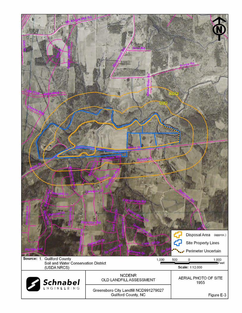
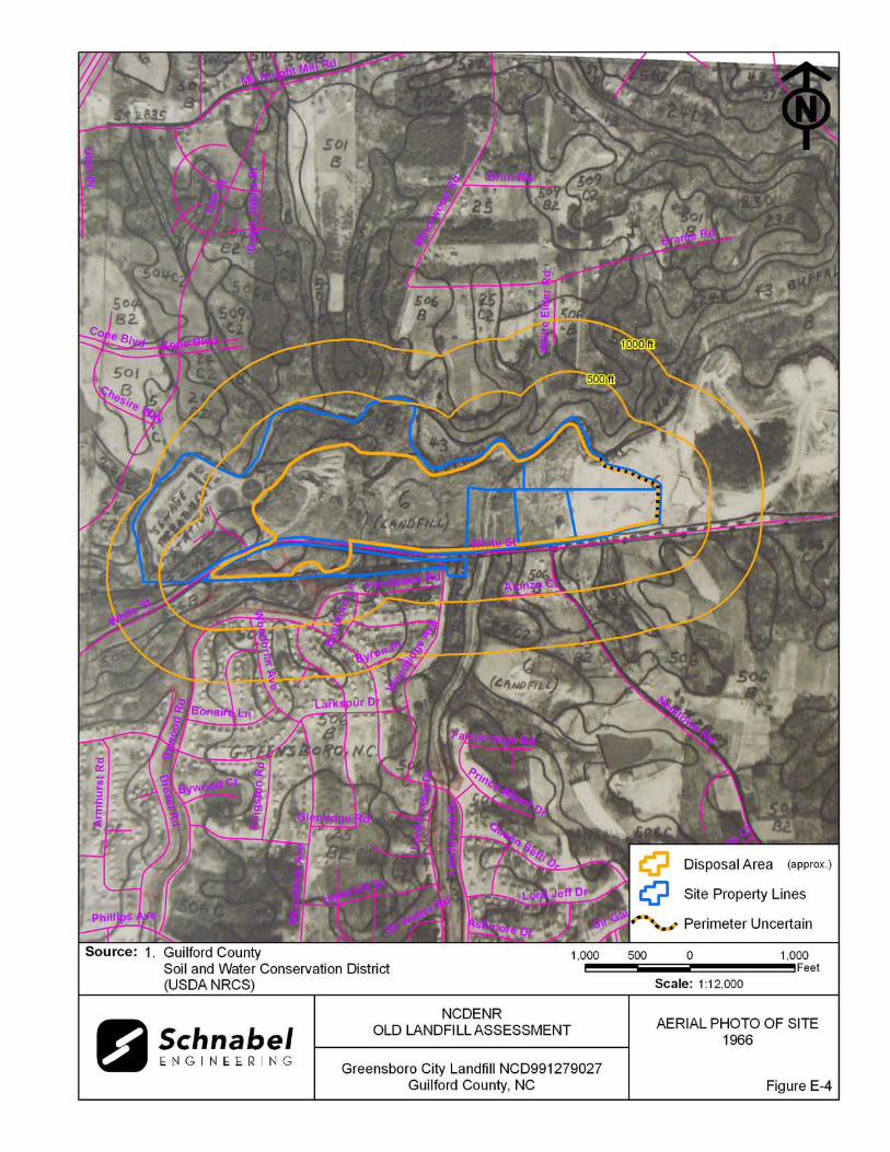
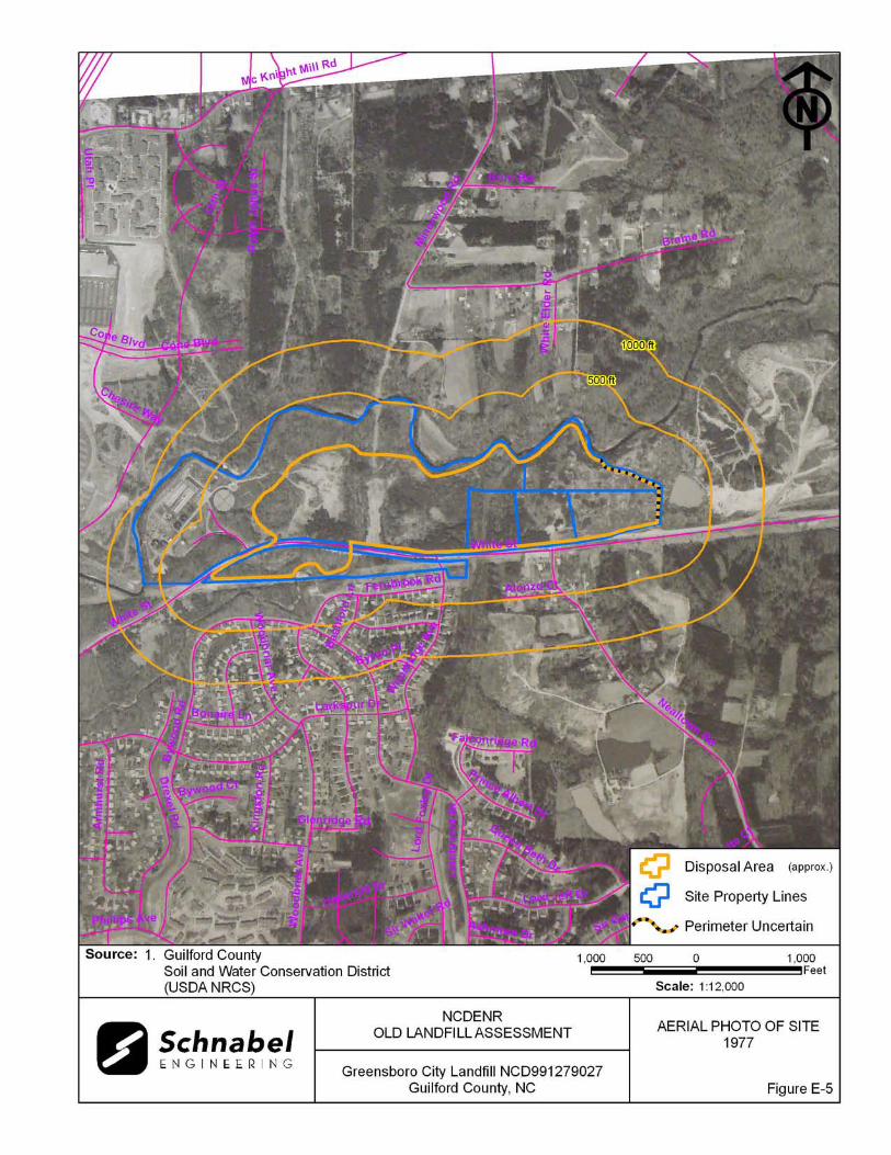


APPENDIX F
SUPPORTING DOCUMENTATION