SITE SELECTION STUDY -...
38
SITE SELECTION STUDY REPLACEMENT FOR KEMPS LANDING MAGNET SCHOOL AND OLD DONATION CENTER August 15, 2012
Transcript of SITE SELECTION STUDY -...

�
SITE SELECTION STUDYREPLACEMENT FOR
KEMPS LANDING MAGNET SCHOOLAND OLD DONATION CENTER
August 15, 2012

Site Design Parameters . . . . . . . . . . . . . . . . . . . . . . . . . . . . . . . . . . . . . . . . . . . . . . . . . . . . . . . . . . . . . . . . . 04
TABLE OF CONTENTS
INTRODUCTION
KEMPS LANDING MAGNET SCHOOL
OLD DONATION CENTER SCHOOL
Zoning . . . . . . . . . . . . . . . . . . . . . . . . . . . . . . . . . . . . . . . . . . . . . . . . . . . . . . . . . . . . . . . . . . . . . . . . . . . . . . . . . 08Utilities . . . . . . . . . . . . . . . . . . . . . . . . . . . . . . . . . . . . . . . . . . . . . . . . . . . . . . . . . . . . . . . . . . . . . . . . . . . . . . . . . �0Circulation . . . . . . . . . . . . . . . . . . . . . . . . . . . . . . . . . . . . . . . . . . . . . . . . . . . . . . . . . . . . . . . . . . . . . . . . . . . . . �4Environmental . . . . . . . . . . . . . . . . . . . . . . . . . . . . . . . . . . . . . . . . . . . . . . . . . . . . . . . . . . . . . . . . . . . . . . . . . . �5A New School . . . . . . . . . . . . . . . . . . . . . . . . . . . . . . . . . . . . . . . . . . . . . . . . . . . . . . . . . . . . . . . . . . . . . . . . . . �8Alternative Future Development . . . . . . . . . . . . . . . . . . . . . . . . . . . . . . . . . . . . . . . . . . . . . . . . . . . . . . . . . . 20
Utilities . . . . . . . . . . . . . . . . . . . . . . . . . . . . . . . . . . . . . . . . . . . . . . . . . . . . . . . . . . . . . . . . . . . . . . . . . . . . . . . . . 24Circulation . . . . . . . . . . . . . . . . . . . . . . . . . . . . . . . . . . . . . . . . . . . . . . . . . . . . . . . . . . . . . . . . . . . . . . . . . . . . . 28Environmental . . . . . . . . . . . . . . . . . . . . . . . . . . . . . . . . . . . . . . . . . . . . . . . . . . . . . . . . . . . . . . . . . . . . . . . . . . 29A New School . . . . . . . . . . . . . . . . . . . . . . . . . . . . . . . . . . . . . . . . . . . . . . . . . . . . . . . . . . . . . . . . . . . . . . . . . . 3�Alternative Future Development . . . . . . . . . . . . . . . . . . . . . . . . . . . . . . . . . . . . . . . . . . . . . . . . . . . . . . . . . . 33
PLAZA ANNEX Alternative Site . . . . . . . . . . . . . . . . . . . . . . . . . . . . . . . . . . . . . . . . . . . . . . . . . . . . . . . . . . . . . . . . . . . . . . . . . . . . 35
ENVIRONMENTAL AND ECONOMIC SUSTAINABILITY . . . . . . . . . . . . . . . . . . . . . . . . . . . . . . . . . . . . . . . . . . 36
CONCLUSIONS . . . . . . . . . . . . . . . . . . . . . . . . . . . . . . . . . . . . . . . . . . . . . . . . . . . . . . . . . . . . . . . . . . . . . . . . . . . . . . . 37
Site Selection . . . . . . . . . . . . . . . . . . . . . . . . . . . . . . . . . . . . . . . . . . . . . . . . . . . . . . . . . . . . . . . . . . . . . . . . . . . 03
Existing Sites . . . . . . . . . . . . . . . . . . . . . . . . . . . . . . . . . . . . . . . . . . . . . . . . . . . . . . . . . . . . . . . . . . . . . . . . . . . 06Similar Sized VB Schools . . . . . . . . . . . . . . . . . . . . . . . . . . . . . . . . . . . . . . . . . . . . . . . . . . . . . . . . . . . . . . . . 05
Zoning . . . . . . . . . . . . . . . . . . . . . . . . . . . . . . . . . . . . . . . . . . . . . . . . . . . . . . . . . . . . . . . . . . . . . . . . . . . . . . . . . 23
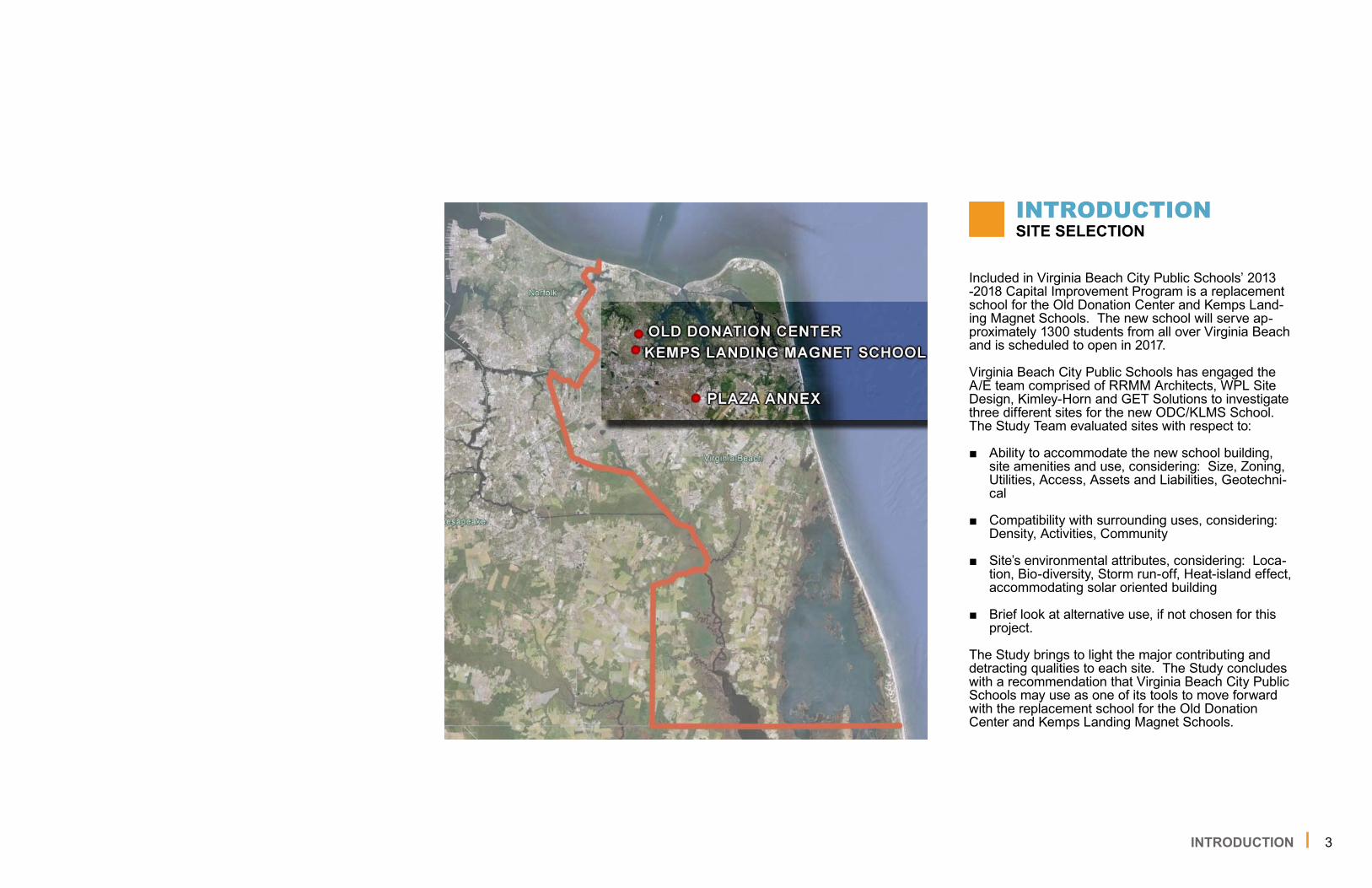
3INTRODUCTION
Included in Virginia Beach City Public Schools’ 20�3 -20�8 Capital Improvement Program is a replacement school for the Old Donation Center and Kemps Land-ing Magnet Schools. The new school will serve ap-proximately �300 students from all over Virginia Beach and is scheduled to open in 20�7.
Virginia Beach City Public Schools has engaged the A/E team comprised of RRMM Architects, WPL Site Design, Kimley-Horn and GET Solutions to investigate three different sites for the new ODC/KLMS School. The Study Team evaluated sites with respect to:
Ability to accommodate the new school building, site amenities and use, considering: Size, Zoning, Utilities, Access, Assets and Liabilities, Geotechni-cal
Compatibility with surrounding uses, considering: Density, Activities, Community
Site’s environmental attributes, considering: Loca-tion, Bio-diversity, Storm run-off, Heat-island effect, accommodating solar oriented building
Brief look at alternative use, if not chosen for this project.
The Study brings to light the major contributing and detracting qualities to each site. The Study concludes with a recommendation that Virginia Beach City Public Schools may use as one of its tools to move forward with the replacement school for the Old Donation Center and Kemps Landing Magnet Schools.
■
■
■
■
INTRODUCTIONSITE SELECTION

4
A study of educational specifications completed on May �2, 20�2 by DeJong-Richter and RRMM Archi-tects lays out a range of amenity and spatial require-ments for the specialized education of gifted students. Site related items from these specifications are sum-marized below. They reflect potential design elements for the site concepts presented in this site selection study.
Lighting Include exterior security lighting with motion detec-tors and/or photo-cell timer for parking lots and exterior of building Provide appropriate lighting for athletic and prac-tice fields Provide appropriate lighting for walkways Provide lighting that is easy to maintain and se-cure against vandalism Must be easy to maintain and service
Landscaping Create landscaped areas that are sustainable & minimize use of an irrigation system where pos-sible Low-maintenance landscaping plantings Consider outdoor spaces as an extension of the classroom and opportunities for exploration and education Recycling facilities Student-friendly Places to rest and read Trees for shade Benches around trees Sufficient green space
■
■
■■
■
■
■■
■■■■■■
Sheltered Areas For inclement weather Outdoor class work Waiting for parents Before/after school activities Away from noise Covered Play Areas Games/Physical Education Before/after school activities “Outdoor gymnasium” Picnic tables and benches
Playing Fields Accommodate appropriate summer and winter play activities Secure and safe playing fields for students with direct access from the building Equipment: goals & baskets Drinking fountains located throughout playing fields Running / Walking track Fitness trail 2 Multi-purpose fields � Softball field � outdoor basketball court 2 Tennis courts (multipurpose hard courts) 2nd-5th grade playground Large wall on exterior of building for wall ball
Suggestions from lab participants of site issues to be addressed:
Determine site Separate drives for visitors & faculty Landscaping Multipurpose playing & practice fields
■■■■■■■■■■
■
■
■■■■■■■■■■
■■■■
INTRODUCTIONSITE DESIGN PARAMETERS
INTRODUCTION
KEMPS LANDING MAGNET SCHOOL
PLAZA ANNEX
OLD DONATION CENTER
5
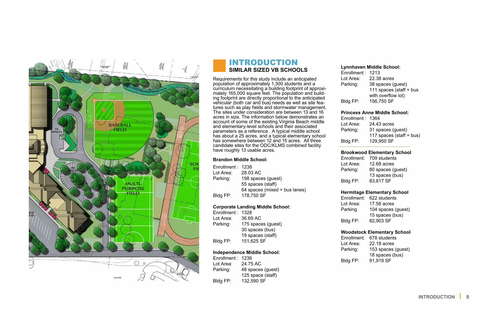
Requirements for this study include an anticipated population of approximately �,300 students and a curriculum necessitating a building footprint of approxi-mately �65,000 square feet. The population and build-ing footprint are directly proportional to the anticipated vehicular (both car and bus) needs as well as site fea-tures such as play fields and stormwater management. The sites under consideration are between �3 and �6 acres in size. The information below demonstrates an account of some of the existing Virginia Beach middle and elementary-level schools and their associated parameters as a reference. A typical middle school has about a 25 acres, and a typical elementary school has somewhere between �2 and �5 acres. All three candidate sites for the ODC/KLMS combined facility have roughly �3 usable acres.
Brandon Middle School:Enrollment : �238Lot Area: 28.03 ACParking: �98 spaces (guest) 55 spaces (staff) 64 spaces (mixed + bus lanes)Bldg FP: �78,750 SF
Corporate Landing Middle School:Enrollment : �328Lot Area: 36.69 ACParking: �75 spaces (guest) 30 spaces (bus) �9 spaces (staff)Bldg FP: �5�,625 SF
Independence Middle School:Enrollment : �236Lot Area: 24.75 ACParking: 48 spaces (guest) �25 space (staff)Bldg FP: �32,590 SF
Lynnhaven Middle School:Enrollment : �2�3Lot Area: 22.38 acresParking: 38 spaces (guest) ��� spaces (staff + bus with overflow lot)Bldg FP: �56,750 SF
Princess Anne Middle School:Enrollment : �364Lot Area: 24.43 acresParking: 3� spaces (guest) ��7 spaces (staff + bus)Bldg FP: �29,950 SF
Brookwood Elementary SchoolEnrollment: 709 studentsLot Area: �2.68 acresParking: 80 spaces (guest) �3 spaces (bus)Bldg FP: 83,8�7 SF
Hermitage Elementary SchoolEnrollment: 622 studentsLot Area: �7.58 acresParking �04 spaces (guest) �5 spaces (bus)Bldg FP: 82,903 SF
Woodstock Elementary SchoolEnrollment: 678 studentsLot Area: 22.�8 acresParking: �53 spaces (guest) �8 spaces (bus)Bldg FP: 9�,9�9 SF
INTRODUCTIONSIMILAR SIZED VB SCHOOLS
INTRODUCTION

6
Since the two existing school facilities are to be combined, the three sites become candidates for hosting the combined facility. Kemps Landing Magnet School (KLMS), Old Donation Center (ODC) and Plaza Annex (PA) are ideal for study in that they are mostly contigu-ous lots currently owned by the school system. All of the sites are ingrained in their communities and KLMS and ODC are only a mile
apart from each other. KLMS and ODC both have excellent access to Independence Boulevard and Plaza Annex has excellent access to South Lynnhaven Road, which connects directly to Lynnhaven Parkway. However, by many accounts, they are not equal sites. This study will compare the three sites and their acceptability for redevel-opment for a much larger school facility and program.
INTRODUCTION
INTRODUCTIONEXISTING SITES
KEMPS LANDING MAGNET SCHOOL OLD DONATION CENTER PLAZA ANNEX

KLMSKEMPS LANDING MAGNET SCHOOL

8KLMS ZONING
The KLMS site is a �3 acre parcel adjacent to Pem-broke Elementary School fronting on the same road. The school currently has approximately 600 students. VB Schools own an additional 5.6 acre parcel behind and contiguous to the KLMS site. This parcel housed the former sewage treatment plant for the City and is now vacant. The existing KLMS site and the vacant parcel to its rear are considered to comprise the full site for redevelopment potential. Although this ad-ditional parcel adds more land to the KLMS parcel, much of it is encumbered by water, wetlands, an awk-ward geometry, and other access or utilities concerns. Any new development plan will also need to consider vacating the lot line between the two parcels in order to be able to legally work on one lot. An interior lot line can sometimes cause problems later when property needs to change hands, and depending on zoning discretion can introduce setbacks that may otherwise complicate development.
Another interesting issue concerning the KLMS parcel is that the Pembroke Elementary School site appears to encroach on the east side of the lot. The corner of the neighboring school overlaps the lot line and the bus loop and staff parking appear to be entirely lo-cated on the KLMS parcel. For two parcels owned by one entity, this is not always an issue to contend with, however, it may be prudent to subdivide the parcel line around the encroachment in order to prevent future complication when development occurs or property changes hands.
While not overly complicated and not a high cost item, the subdivision and adjustments to the KLMS parcel should be considered early in the design phase of any attempts to redevelop this site. The process for a lot line adjustment and a subdivision of the parcel may take several months for coordination and municipal review and should be considered concurrently with any design program.
Per the FIRM Map Number 5�553�0082F, revised May 4, 2009, KLMS is primarily in Zone X (outside of the 500-year flood plain), with the rear portion of the site in zone AE, with a �00-year base flood elevation of 9.0.
The KLMS site is outside of any aircraft noise zones and the aircraft accident potential zones from nearby airfields.
ZONINGINITIAL BOUNDARY

9KLMS ZONING
The KLMS site, once compiled as one parcel should simplify design and construction for any new facility and grounds intended for its future. This will allow the school system the flexibility to consider other develop-ment opportunities should the need or opportunity arise. Future work on Pembroke Elementary School will also be simplified for any site work or renovations.
The KLMS site and its constituent parcels are zoned as R7.5. The building setbacks for this zoning district are �5-feet in the side and rear yards and 30-feet in the front yard. Since this zoning designation considers a school as a permitted use, there is no Conditional Use Permit required for developing this site as a future school. This will save some time and soft costs as development potential is explored.
New development should consider not only the set-backs but other requirements such as limited height, category screening, and buffering from adjacent residential uses.
ZONINGPOTENTIAL BOUNDARY
USABLE SITE AREA
13.5 ACRES

�0KLMS UTILITIES
The site is served with overhead electrical service from Jericho Road and Spooner Road. The service line from Jericho Road is located between KLMS and Pembroke Elementary School, ending along the back of both buildings. The Spooner Road service line crosses the baseball field in the northwest portion of the site and ends at the building. These lines are likely located within a private utility easement, but confirma-tion will be required. All overhead electrical lines on site may need to be removed or rerouted in order to enable site development.
Other private franchise utilities, such as gas, cable, and communications are available to the site and should be located by the individual companies via Miss Utility and marked on site prior to construction. This can be done under a design ticket prior to survey-ing the site in order to get an approximate location of these utilities. Occasionally, some private utilities can prove difficult to determine their underground loca-tions. If necessary, an underground utility mapping consultant may be considered to methodically locate stray lines or pipes otherwise obscured from paper records or evidence above ground.
A contractor charged with any construction will be required to call in a construction ticket to Miss Utility in order to gain an understanding of what may be on site.
UTILITIES PRIVATE
LEGEND
ITEM TO BE REMOVED ELECTRICAL LINES

��KLMS UTILITIES
City records indicate that the site is served by an 8-inch cast iron water main in Jericho Road. This should be sufficient to serve a new school unless low pressure issues exist in this neighborhood, which are unknown at this time. If additional flows or pressures are needed, a 6-inch water main is also available in Spooner Road as a possible interconnection loca-tion. The water lines could potentially be looped for improved pressure. Prior to any new development design a flow test should be performed on the nearest hydrants in order to gain a better understanding of the current flow capacities and pressures surrounding the site. The City would perform these tests and they are often available within a matter of days.
UTILITIES WATER
LEGEND
WATER LINE

�2
UTILITIES SANITARY
KLMS UTILITIES
City records indicate that the site is served by sanitary sewer from Jericho Road. A manhole in front of the existing school building connects an 8” sanitary sewer to a �0” sanitary sewer running west. Based on previ-ous school experience we believe an 8” or �0” line will be adequate to serve the new school. Although invert information was not available for the manhole serving as the connection point for the existing building, inverts for two downstream manholes in Jericho Road are 8.�6’ and 7.60’ respectively according to City records. The existing building has a finished floor elevation of �8.77’. Further analysis is needed to determine the invert for the proposed point of connection to the City system, but it appears that sufficient elevation drop exists from any portion of the buildable area on-site to support gravity sanitary sewer service assuming a proposed finished floor elevation similar to that of the existing building.
City records also show an HRSD-owned �2” force main crossing through the site behind the existing building. This force main may affect the proposed building location. Relocation may be required to ac-commodate the desired building footprint and position on site.
The site is served by City pump station 345 (PS 345) which discharges to a �2” Hampton Roads Sanitation District (HRSD) force main. Analysis provided by the City of Virginia Beach Department of Public Utilities (performed on November �6, 20�0) indicates that PS 345 is nearing capacity. The wet well and/or pumps may need to be upgraded since the proposed sewer flows will be approximately twice the existing flows since the student population of the new school will nearly be double that of the existing school.
LEGEND SANITARY LINE

�3KLMS UTILITIES
The existing drainage system consists of yard inlets around the building and throughout the main parking lot to the west. These catch basins collect storm water from several grassed swales around the building and from the parking lot. There is also a detention basin located near the northwest building corner. The site receives runoff from Spooner Road, so future devel-opment will need to maintain this drainage pattern. Although the storm pipe and structures are difficult to trace, the system primarily outfalls into Thurston Creek behind the school. Ultimately this discharges to a regional storm water management facility for the Independence area referred to in City records as “Pembroke Lake”, this ultimately drains into the western branch of the Lynnhaven River. Pembroke Lake may serve as a regional BMP for this project and may handle quality and quantity from the site’s runoff. There is also a potential to improve the water quality from other areas offsite which drain through the school site.
Any proposed storm water management plan will likely need be an infiltration-based, Low Impact Develop-ment (LID) approach in order to reduce runoff and pol-lutant loading, similar to the methodology implemented on the recent Kellam High School project. Infiltration on-site is entirely dependent upon soil permeability and depth to the water table, which will require geo-technical borings. This can be accomplished with infiltration trenches, cisterns, and other below-grade structural chambers.
UTILITIES STORM
LEGEND
STORM PIPE ITEM TO BE REMOVED
DRAINAGE STORMWATER OUTFALL

�4KLMS CIRCULATION
KLMS is served by access off of Jericho Road with access to / from Independence Boulevard in the east and to / from N. Witchduck Road in the west. School frontage along Jericho Road is approximately 770 feet. The posted speed limit along Jericho Road is 25 mph and roadway width is approximately 30 feet.
Buses and passenger vehicles are currently mixed on site. With the potential redevelopment of the KLMS site, it is recommended that the new school site have separate school bus and passenger vehicle access driveways such that school bus traffic and school related passenger vehicle traffic do not mix. This will result in separate yet controlled student drop-off / pick-up areas (bus vs. passenger car) as well as access for school related traffic (e.g., faculty, staff, visitors).
The proposed bus driveway should be located at least 200 feet west of the Pembroke Elementary School bus driveway to avoid any issues with queuing and blocking the existing driveway. It is recommended the student drop-off / staff driveway be located at a mini-mum of 200 feet west of the proposed bus driveway.
Based on physical observations at the site, we believe the following off-site improvements may be required.
Independence Boulevard / Jericho Road Intersec-tion
Modification of existing signal timing plans■
N. Witchduck Road / Jericho Road Intersection
Modification of existing signal timing plans
Install (8) pedestrian countdown heads for all four (4) crosswalks and their associated approaches at the intersection
Install (8) new pedestrian push button signs
Jericho Road
Install new School Zone Signage Assemblies with Flashing Beacons.
Installation of sidewalks along the north side of Jericho Road from the existing sidewalk located in front of Pembroke Elementary School to Spooner Road.
■
■
■
■
■
CIRCULATION SITE ACCESS / VEHICULAR
LEGEND
ABSENCE OF ACCESS CIRCULATION
ACCESS

�5KLMS ENVIRONMENTAL
Environmental Constraints
A site investigation was performed on the KLMS site. The exterior of KLMS and adjacent properties were visually inspected for signs of environmental conditions that would impact construction activities onsite. Additionally, environmental databases and commonly available historic resources were reviewed to further elucidate past land usage at the site and surrounding properties. The complete results of this investigation are included in a separate Constructabil-ity Environmental Analysis attached to this document for reference. The interior of the KLMS facility was evaluated separately and the results of this evaluation are included in the AHERA Report attached to this document for reference.
The major findings of these two reports are as follows:
Site History
A Phase I ESA was performed in 200� for the rear 5.6 acre parcel located near KLMS.
First construction on the site appears to have oc-curred between �952 and �959, during which time a sewage treatment plant was also constructed adjacent to KLMS to the north
Pembroke Elementary School was constructed adjacent to the east of KLMS bet. �96� and �963
Based on aerial photography the treatment plant was razed between �982 and �990.
■
■
■
■
Site Observations
There is one vent pipe on the southeast corner of the building. No other tank ports were observed on site. Data base review indicates that there were two USTs present at the KLMS facility but that both have been closed either by permanent closure in place, or removal from the ground. Additional research may be required to determine the exact location of these tanks to determine if removal is required to facilitate building construction.
The Aragona Sewage Treatment Facility existed on the northern portion of the site until the early �980s. Past bulk storage of chemicals for the treatment of wastewater and the bulk storage of diesel for emergency backup power, cannot be ruled out. There is the potential for an unknown release to have occurred, as well as abandoned subsurface fuel storage tanks to exist. If construc-tion is proposed in this area, further investigation is warranted.
Per the AHERA Report the building does contain hazardous material that will have to be abated. Ad-ditional sampling will likely be required to determine the extents of this material.
Storm Surge
The rear portion of the KLMS site would be im-pacted by a Category � storm surge. However, the area of impact is limited and the majority of the site would avoid impacts until a Category 4 storm.
Jericho Road serving the site would not be im-pacted until a Category 4 storm.
■
■
■
■
■
ENVIRONMENTALSITE INVESTIGATION

�6KLMS ENVIRONMENTAL
Based on the proximity of the KLMS site to the Thurston Branch of the Lynnhaven River a wetland delineation was performed by a Professional Wetland Delineator. This delineation was submitted to the Army Corps of Engineers on June �2, 20�2 for formal confirmation. Jurisdictional wetlands and waters of the U.S. were generally delineated along the toe-of-slope/shoreline along the northern property boundary. Wetlands identified by the delineation consist of non-tidal wetland areas. Based on feedback received from the City of Virginia Beach Staff, this waterbody is not considered a CBPA feature, and therefore buffering is not required to meet City requirements.
Although the Thurston Creek Branch ultimately flows into this system, it is hydraulically disconnected by a weir wall near Independence Boulevard. This discon-nect renders the KLMS site as not having a Bay buffer.
Although the site does not have a CBPA boundary, there is merit to preserving and enhancing the wet-lands perimeter on site. This area is approximately one and one-half of an acre along the creek. Provid-ing supplemental planting and sustainable design techniques, such as a living shoreline, will enable improved stormwater quality for the neighborhood and the site.
ENVIRONMENTALWETLANDS

�7KLMS ENVIRONMENTAL
A geotechnical report and borings have been per-formed for this site. The soil borings have been taken across the site, and to date, there appear to be no complications or requirements for additional building pilings.
General soil characteristics for this site are as follows:
Approximately 3 different soil types exist on site
Soils are somewhat poorly to moderately drained
Shallow water table of approximately �2 to 30 inches will limit ability to infiltrate stormwater.
Available water capacity = 8 to �0 inches
Typical profile = Loam to Clay Loam to Loamy Sand
Infiltration rates are generally slow when thoroughly wet and have a slow rate of water transmission. A percolation test will need to be performed prior to any final stormwater design.
■
■
■
■
■
ENVIRONMENTALGEOTECHNICAL
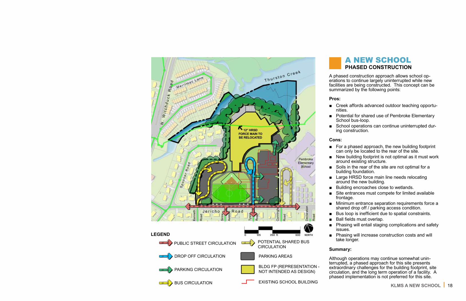
�8KLMS A NEW SCHOOL
A phased construction approach allows school op-erations to continue largely uninterrupted while new facilities are being constructed. This concept can be summarized by the following points:
Pros:Creek affords advanced outdoor teaching opportu-nities. Potential for shared use of Pembroke Elementary School bus-loop.School operations can continue uninterrupted dur-ing construction.
Cons:For a phased approach, the new building footprint can only be located to the rear of the site.New building footprint is not optimal as it must work around existing structure.Soils in the rear of the site are not optimal for a building foundation.Large HRSD force main line needs relocating around the new building.Building encroaches close to wetlands.Site entrances must compete for limited available frontage.Minimum entrance separation requirements force a shared drop off / parking access condition. Bus loop is inefficient due to spatial constraints.Ball fields must overlap.Phasing will entail staging complications and safety issues.Phasing will increase construction costs and will take longer.
Summary:
Although operations may continue somewhat unin-terrupted, a phased approach for this site presents extraordinary challenges for the building footprint, site circulation, and the long term operation of a facility. A phased implementation is not preferred for this site.
■
■
■
■
■
■
■
■■
■
■■■
■
A NEW SCHOOLPHASED CONSTRUCTION
LEGEND
PUBLIC STREET CIRCULATION POTENTIAL SHARED BUSCIRCULATION
PARKING AREAS
BLDG FP (REPRESENTATION - NOT INTENDED AS DESIGN)
DROP OFF CIRCULATION
PARKING CIRCULATION
BUS CIRCULATION EXISTING SCHOOL BUILDING

�9KLMS A NEW SCHOOL
A tear down and rebuild approach will require school operations to stop or be temporarily relocated during the construction of the new building, parking and drive aisles. This concept can be summarized by the follow-ing points:
Pros:Creek affords advanced outdoor teaching opportu-nities. Potential for shared use of Pembroke Elementary School bus-loop.Ability to preserve more buffer around wetlands.Parking and drop off areas can be separated.Building arrangement allows for some flexibility in the footprint.Tear down and rebuild will be less expensive and will be completed in a shorter time frame.
Cons:Insufficient frontage forces athletic fields to rear of site.Building footprint is restricted by parking on either side.Ball fields must overlap.School operations must continue elsewhere during construction.
Summary:
A tear down and rebuild approach allows for improved circulation and a more flexible footprint when com-pared to a phased approach. A tear down and rebuild approach is preferred in order to fully optimize the facility and its site circulation.
■
■
■■■
■
■
■
■■
A NEW SCHOOLTEAR DOWN AND REBUILD
LEGEND
PUBLIC STREET CIRCULATION POTENTIAL SHARED BUSCIRCULATION
PARKING AREAS
BLDG FP (REPRESENTATION - NOT INTENDED AS DESIGN)
DROP OFF CIRCULATION
PARKING CIRCULATION
BUS CIRCULATION
20KLMS ALTERNATIVE FUTURE DEVELOPMENT
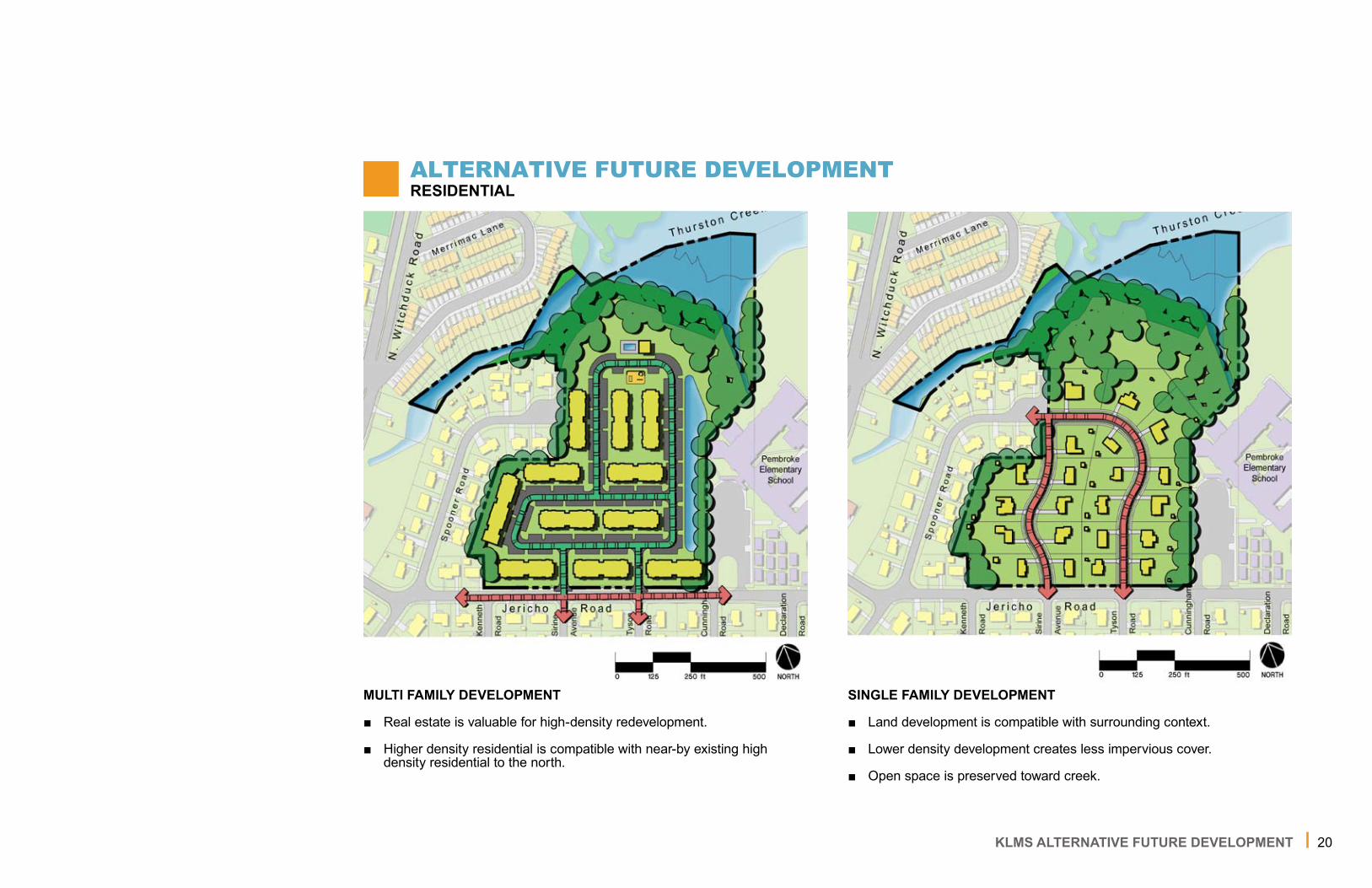
ALTERNATIVE FUTURE DEVELOPMENTRESIDENTIAL
SINGLE FAMILY DEVELOPMENT
Land development is compatible with surrounding context.
Lower density development creates less impervious cover.
Open space is preserved toward creek.
■
■
■
MULTI FAMILY DEVELOPMENT
Real estate is valuable for high-density redevelopment.
Higher density residential is compatible with near-by existing high density residential to the north.
■
■

2�KLMS ALTERNATIVE FUTURE DEVELOPMENT
ALTERNATIVE FUTURE DEVELOPMENTRECREATIONAL
PASSIVE RECREATIONAL
Complimentary use for surrounding neighborhoods.
Open space can provide opportunities for expanded school curriculum in science and agriculture.
■
■
ACTIVE RECREATIONAL
Open space and athletic amenities will be available to school system, Pembroke Elementary School, and the surrounding neighborhoods.
Existing lit ball fields from ODC can be relocated to this site and ex-panded.
■
■

ODCOLD DONATION
CENTER
23ODC ZONING
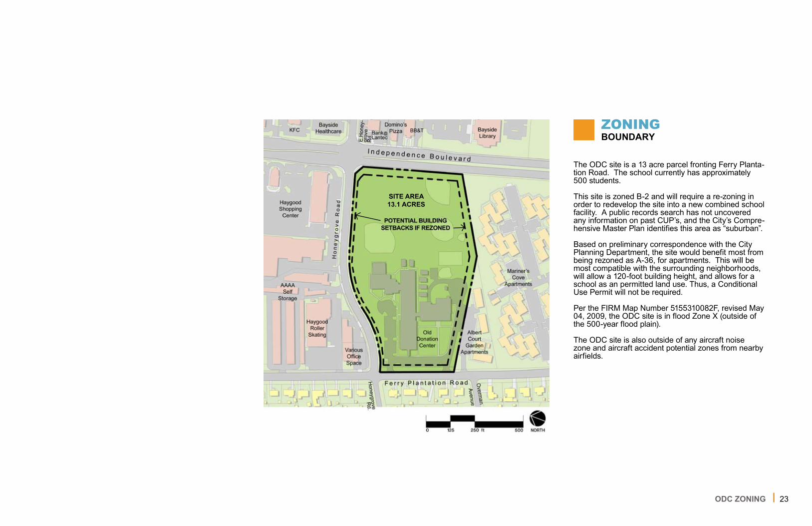
The ODC site is a �3 acre parcel fronting Ferry Planta-tion Road. The school currently has approximately 500 students.
This site is zoned B-2 and will require a re-zoning in order to redevelop the site into a new combined school facility. A public records search has not uncovered any information on past CUP’s, and the City’s Compre-hensive Master Plan identifies this area as “suburban”.
Based on preliminary correspondence with the City Planning Department, the site would benefit most from being rezoned as A-36, for apartments. This will be most compatible with the surrounding neighborhoods, will allow a �20-foot building height, and allows for a school as an permitted land use. Thus, a Conditional Use Permit will not be required.
Per the FIRM Map Number 5�553�0082F, revised May 04, 2009, the ODC site is in flood Zone X (outside of the 500-year flood plain).
The ODC site is also outside of any aircraft noise zone and aircraft accident potential zones from nearby airfields.
ZONINGBOUNDARY
SITE AREA13.1 ACRES

24ODC UTILITIES
The site is served with overhead electrical service from Ferry Plantation Road. The service line runs parallel to the southern property line from Ferry Plan-tation Road to Independence Boulevard, and appears to serve additional properties on either side of the site. This service would need to remain in place or be relocated in order to continue to serve neighboring properties. The electrical lines and poles are likely located within a private utility easement, but confirma-tion will be required.
Other private franchise utilities, such as gas, cable, and communications are known to be available to the site and should be located by the individual companies via Miss Utility and marked on site prior to construc-tion. This can be done under a design ticket prior to surveying the site in order to get an approximate location of these utilities. Occasionally, some private utilities can prove difficult to determine their under-ground locations. If necessary, an underground utility mapping consultant may be considered to methodi-cally locate stray lines or pipes otherwise obscured from paper records or evidence above ground.
A contractor charged with any construction will be required to call in a construction ticket to Miss Utility in order to gain an understanding of what may be on site.
UTILITIESPRIVATE
LEGEND
ITEM TO BE REMOVED ELECTRICAL LINES
25ODC UTILITIES
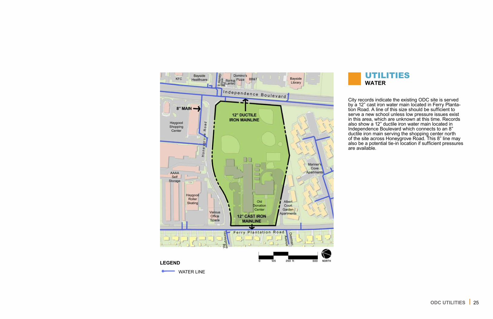
City records indicate the existing ODC site is served by a �2” cast iron water main located in Ferry Planta-tion Road. A line of this size should be sufficient to serve a new school unless low pressure issues exist in this area, which are unknown at this time. Records also show a �2” ductile iron water main located in Independence Boulevard which connects to an 8” ductile iron main serving the shopping center north of the site across Honeygrove Road. This 8” line may also be a potential tie-in location if sufficient pressures are available.
UTILITIESWATER
LEGEND
WATER LINE

26ODC UTILITIES
City records indicate the site is served by a 6” vitrified clay sanitary sewer located on the west side of Ferry Plantation Road. This sanitary sewer may be too small to serve the proposed school building. An 8” sanitary sewer is available on the northwest corner of Ferry Plantation Road and Honeygrove Road. Although connection at this location would require work within the City right-of-way, it may be necessary based on the anticipated flows for the new building. The flows for the new building are expected to be approximately twice the existing flows since the student population of the new school will nearly be double that of the exist-ing school.
Invert information provided by City record drawings shows an invert elevation of �9.52’ for the manhole located at the northwest corner of Ferry Plantation Road and Honeygrove Road. The finished floor eleva-tions for the ODC building range from 26.87’ to 30.00’ according to City records. This amount of elevation drop may be insufficient if the proposed building is moved closer to Independence Boulevard without rais-ing the finished floor elevation. The existing developed area on-site should have sufficient elevation drop to connect to the manhole at the corner of Honeygrove Road and Ferry Plantation Road.
The site is served by City pump station 339 (PS 339) which discharges to a 6” HRSD force main. The Pump Station 339 – Haygood Shopping Center Preliminary Engineering Report Phase I completed by Michael
Baker Jr., Inc. in February 20�0 indicates the wet well has adequate capacity for existing flows but not for the ultimate build-out conditions of the entire service area. The report also indicates the pumps are adequately sized for existing flow and head conditions, but are not adequately sized to meet the HRSD Interceptor Force Main (IFM) Policy maximum head condition. Further assessment of PS 339 is needed to determine the affect the new school will have, if any, on the existing pump station. Upgrades to the pump station may be required since the flows for the new school will be approximately twice those for the existing school.
UTILITIESSANITARY
LEGEND SANITARY LINE

27ODC UTILITIES
The site is drained through a series of grassed swales and linear detention basins. Grassed swales along Honeygrove Road receive runoff from Honeygrove Road and likely serve as a bypass for the adjacent linear detention basins. There is also a detention basin located at the northeast corner of the building which discharges to the storm sewer system located in Hon-eygrove Road. The southern portion of the site drains to a ditch located along the southern property bound-ary. This ditch also receives drainage from the Albert Court Garden Apartments complex, and discharges to a relatively small culvert (field verified �6” diameter) beneath Independence Boulevard.
The proposed storm water management plan will be designed in accordance with the proposed methodol-ogy stated in the KLMS storm water section. Also, further analysis is needed for the potentially under-sized culvert beneath Independence Boulevard since both off-site and on-site drainage outfall through this culvert.
UTILITIESSTORM
LEGEND
STORM PIPE ITEM TO BE REMOVED
DRAINAGE STORMWATER OUTFALL

28ODC CIRCULATION
The site is bound by Independence Boulevard to the east, Honeygrove Road to the north, and Ferry Planta-tion Road to the west. The frontage along Honeygrove Road is approximately �,�00 feet and the frontage along Ferry Plantation Road is approximately 400 feet. The posted speed limit along Independence Boule-vard is 45 mph, Honeygrove Road is posted at 25 mph, and Ferry Plantation Road is posted at 30 mph. Honeygrove Road and Ferry Plantation Road are both approximately 36 feet wide.
Buses and passenger vehicles are currently mixed on site. With the potential redevelopment of the ODC site, it is recommended that the proposed school site have two full site access driveways. One driveway serv-ing school buses only and one site access driveway for passenger vehicle access only. This will result in separate yet controlled student drop-off/pick-up areas (bus vs. passenger car) as well as access for school related traffic (e.g., faculty, staff, visitors). If one of these driveways is proposed along Honeygrove Road, it is recommended that it align directly with one of the shopping center driveways located along the north side of the road.
Based on physical observations at the site, the follow-ing off-site improvements may be required:
Independence Boulevard / Honeygrove Road Intersection
Modification of existing signal timing plans
Honeygrove Road
Construction of sidewalk along the south side of Honeygrove Road between Ferry Plantation Road and Independence Boulevard.
Installation of new School Zone Signage Assem-blies and Flashing Beacons and in road pavement markings.
Ferry Plantation Road
Construct sidewalk along the east side of the Ferry Plantation Road between Honeygrove Road to the north and the south site access driveway. Utilities may need to be relocated due to conflicts with util-ity poles on both sides of the roadway.
■
■
■
■
CIRCULATION SITE ACCESS / VEHICULAR
LEGEND
ABSENCE OF ACCESS CIRCULATION
ACCESS

29ODC ENVIRONMENT
Environmental Constraints
A site investigation was performed on the ODC site. The exterior of ODC and adjacent properties were visually inspected for signs of environmental condi-tions that would impact construction activities onsite. Additionally, environmental databases and commonly available historic resources were reviewed to further reveal past land usage at the site and surrounding properties. The complete results of this investigation are included in a separate site Environmental Analysis attached to this document for reference. The interior of the ODC facility was evaluated separately and the results of this evaluation are included in the AHERA Report attached to this document for reference.
The major findings of these two reports are as follows:
Site History
First construction on the site appears to have oc-curred between �963 and �970.
Since construction, the surrounding area has been characterized by increased residential growth the south and west and commercial growth to the north and east.
Site Observations
One pad-mounted transformer is present on the east side of the building. This transformer does not have a non-PCB sticker. This could require special-ized handling for removal.
■
■
■
Review of database records indicates that im-pacted soil was found in conjunction with the removal of a diesel fuel UST at the site. This find-ing warrants additional investigation in advance of construction to determine the extent of the impact as well as further elucidate final design consider-ations.
The facility is a conditionally exempt hazardous waste generator. This was likely due to previous removal of site material and does not provide concern for future development.
Per the AHERA Report the building does contain hazardous material that will have to be abated. Ad-ditional sampling will likely be required to determine the extents of this material.
Wetland Determination
It does not appear that any wetlands are present on the ODC site and therefore a formal delineation was not performed.
Storm Surge
The ODC site is located outside of Category 4 and smaller storm surges.
■
■
■
■
■
ENVIRONMENTALSITE INVESTIGATION

30
A geotechnical report and borings have been per-formed for this site. The soil borings have been taken across the site, and to date, there appear to be no complications or requirements for additional building pilings.
General soil characteristics for this site are as follows:
Approximately 2 different soil types exist on site.
Soils are well-drained.
Approximate water table of 48 to 72 inches depth is ideal for stormwater infiltration.
Available water capacity = 9.5 inches.
Typical profile = Loam to Loam to Sandy Loam.
Infiltration rates are generally moderate when thor-oughly wet and have a moderate rate of water trans-mission. A percolation test will need to be performed prior to any final stormwater design.
■
■
■
■
■
ENVIRONMENTALGEOTECHNICAL
UPDATE
ODC ENVIRONMENTAL

3�ODC A NEW SCHOOL
A NEW SCHOOLPHASED CONSTRUCTION
A phased construction approach allows school op-erations to continue largely uninterrupted while new facilities are being constructed. This concept can be summarized by the following points:
Pros:School operations can continue uninterrupted dur-ing construction.Multiple frontage access points afford high level of design flexibility.
Cons:For a phased approach, the new building footprint can only be located to the southeast corner of the site. The southeast corner of the site is the existing stormwater outfall and a low area.A building pad near Independence Blvd. must be significantly raised to contend with a shallow sani-tary system.Scale of building near multifamily residential is imposing.Proximity of drop-off access to Independence may require parents to approach the site via Ferry Plantation Road.Ball fields must overlap.Phasing will entail staging complications and raise potential safety issues.Phasing will increase construction costs and will take longer.
Summary:
Although operations may continue somewhat uninter-rupted, a phased approach for this site presents sev-eral challenges for the building footprint, offsite circula-tion, utilities and the long term operation of a facility. Phased implementation for this site is not preferred.
■
■
■
■
■
■
■
■■
■
PARKING CIRCULATION
LEGEND
PUBLIC STREET CIRCULATION
PARKING AREAS
BLDG FP (REPRESENTATION - NOT INTENDED AS DESIGN)
DROP OFF CIRCULATION
BUS CIRCULATION
EXISTING SCHOOL BUILDING

32ODC A NEW SCHOOL
A NEW SCHOOLTEAR DOWN AND REBUILD
PARKING CIRCULATION
LEGEND
PUBLIC STREET CIRCULATION
PARKING AREAS
BLDG FP (REPRESENTATION - NOT INTENDED AS DESIGN)
DROP OFF CIRCULATION
BUS CIRCULATION
A tear down and rebuild approach will require school operations to stop during the construction of the new building, parking and drive aisles. This concept can be summarized by the following points:
Pros:Multiple frontage access points afford a high level of design flexibility. The southeast corner of the site can accomodate existing stormwater outfall.Centralized building location is well suited for the existing shallow sanitary system.Footprint centered on site allows for a building height without an imposing scale on neighboring sites.Rezoning would allow more room for greater build-ing height.No overlapping ball fields.One lighted field may be retained from the prede-veloped site.Drop-off is located away from major intersection. Tear down and rebuild will be less expensive and will be completed in a shorter time frame.
Cons:Buses may need to approach site via Ferry Planta-tion Road due to proximity of bus-loop access to Independence Boulevard. School operations must continue elsewhere during construction.
Summary:
A tear down and rebuild approach allows for improved on and off site circulation, a flexible building footprint, and is suited to existing drainage and sanitary condi-tions when compared to a phased approach. A tear down and rebuild approach for this site is preferred.
■
■
■
■
■
■■
■■
■
■
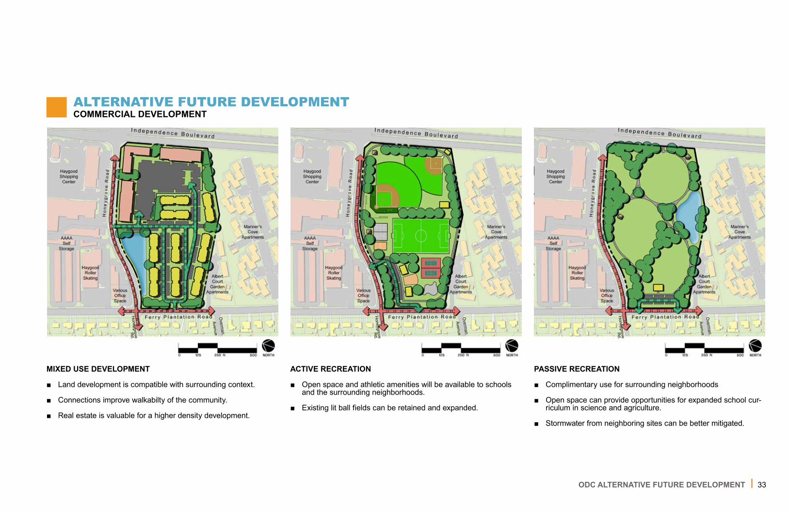
33ODC ALTERNATIVE FUTURE DEVELOPMENT
MIXED USE DEVELOPMENT
Land development is compatible with surrounding context.
Connections improve walkabilty of the community.
Real estate is valuable for a higher density development.
■
■
■
ALTERNATIVE FUTURE DEVELOPMENTCOMMERCIAL DEVELOPMENT
ACTIVE RECREATION
Open space and athletic amenities will be available to schools and the surrounding neighborhoods.
Existing lit ball fields can be retained and expanded.
■
■
PASSIVE RECREATION
Complimentary use for surrounding neighborhoods
Open space can provide opportunities for expanded school cur-riculum in science and agriculture.
Stormwater from neighboring sites can be better mitigated.
■
■
■

PA
PLAZA ANNEX

35
The Plaza Annex site is located to the northwest of Lynnhaven Mall. The parcel totals �4.9 acres. It is bounded to the east by Carriage Hill Road, to the south by Ferry Farm Lane, to the north by Brookwood Elementary School and to the west by a portion of the eastern branch of the Lynnhaven River. It is zoned R7.5 and a school building is a permitted use.
The Plaza Annex site is in aircraft noise zone 75 DB LDN and may be subject to above average noise levels due to its proximity to aircraft operations. How-ever, the site is outside the defined Aircraft Accident Potential Zone (APZ). The quality of the existing build-ing is very high according to the 2007 Comprehensive Facilities Plan and asbestos abatement has already been performed.
This site has approximately 500 linear feet of frontage on Carriage Hill Road and �,000 linear feet on Ferry Farm Lane. Both streets are residential and queuing in front of homes and driveways would need to be evaluated. Entrances along Ferry Farm Lane would be more desirable based on the greater separation from S. Lynnhaven Road.
Based on its proximity to the eastern branch of the Lynnhaven River, a �00’ CBPA RPA buffer would ap-ply to the site. The presence of the CBPA RPA buffer on site will provide additional permit requirements and limit the developable area to �3.5 acres. However, the presence of a natural water body on the rear of the site will provide additional opportunities for outdoor learning spaces and educational experiences for students.
This site has excellent frontage along two sides of the property, and the usable acreage is comparable to the ODC and KLMS sites. Although the same land use components can be accommodated on site, the parcel configuration and site access would be difficult to arrange if construction were to be phased.
The rear portion of this site would be impacted by a Category 2 or larger storm surge. The public streets providing access to the site would be impacted by a Category 3 or larger storm surge.
Review of City GIS data shows a 6-inch water pipe in both Ferry Farm and Carriage Hill Road. A 6-inch pipe may be insufficient to provide the needed flows and pressures to the site to provide both domestic water and fire protection. If this system is insufficient for the needs of a new school, off-site water upgrades may be required. GIS data also shows an 8-inch sanitary sewer pipe in Ferry Farm Road. This appears to be the upstream end of the system and therefore the line may be shallow making a site connection chal-lenging.
Pros:Good frontage for site access and internal circula-tion.Creek affords advanced outdoor teaching opportu-nities.
Cons:Existing school building is in good condition.Offsite circulation may be problematic for nearby residences and adjacent existing school (Brook-wood ES).Water service may be insufficient for program requirements of a new combined facility.Sanitary service may be insufficient for program requirements of a new combined facility.Site is located in a high noise zone.A new combined school facility will cause the exist-ing facility programs on site to be relocated.
Summary:
Considering the good condition of the building and the existing traffic and utility constraints, this site poses some significant challenges for redevelopment as a combined ES/MS school facility. Redevelopment of this site is not preferred.
■
■
■■
■
■
■■
ALTERNATIVE SITEPLAZA ANNEX
PLAZA ANNEX

36
Evaluation of site choices considers each site relative to environmental stewardship and liability. Factors considered included but were not limited to:
Environmental diversity and contribution
Existing environmental liability
Proximity to people served
Ability to connect and contribute to neighborhood diversity
Ability to preserve open space, natural landscape, plant life
Ability to treat storm water on site
Ability to accommodate a solar orientated building
Impact of development’s heat island effect on sur-rounding properties
The summary of findings is as follows:
The Plaza Annex and KLMS sites include sensitive and contributory wetlands that, when developed, will benefit from a less intense use. The public ownership of the sites also lends itself to treating quality of off-site storm water run-off as well. However, the biodiver-sity of these sites make them great choices from an educational setting perspective. Given that the new school project has the choice of the ODC site, a less intense development would be recommended for the Plaza Annex and KLMS sites.
■
■
■
■
■
■
■
■
While Plaza Annex has been abated of hazardous materials, the KLMS and ODC buildings have hazard-ous materials and at least one should take advantage of this project to remediate an environmental liability.
Site location affects vehicular fuel burned to move people to and from the school on a daily basis. Both students and faculty come from all parts of the city. Where students come from each year changes. Con-sequently, a school located at any of the sites will have roughly the same impact on fuel consumption.
With respect to community connectivity, the ODC site is uniquely situated bridging commercial and residen-tial uses.
Development of all three sites will have a similar effect on open space for natural setting.
All three sites will allow a new school building to have optimal solar orientation.
The access from two streets suits the ODC site to hav-ing less need for impervious pavement, meaning less storm water run-off and less potential for heat island effect. Less pavement could also equate to less cost.
In terms of sustainability, the positive attributes of community connectivity, the avoidance of sensitive wetlands, and the potential for less pavement give the ODC site a slight lead among the three sites evalu-ated.
SITE SUSTAINABILITYENVIRONMENTAL AND ECONOMIC
ENVIRONMENTAL AND ECONOMIC SUSTAINABILITY

37
CONCLUSIONSITE SELECTION MATRIX
CONCLUSION
PAODCKLMS
ALTERNATIVE LAND USE
DESIGN FLEXIBILITY
MOST FAVORABLEFOR COMBINED SCHOOL FACILITY
CIRCULATION / ACCESS
USABLE / BUILDABLE AREA
DEMO READY
WETLANDS
WATER
STORM
SANITARY
SUSTAINABILITY
ZONING / BOUNDARY
COMPATIBILITY WITH CONTEXT
FLOOD / STORM SURGE
GEOTECHNICAL

38
The 2007 Comprehensive Facilities Plan assigned a condi-tion index to each school facility. Plaza Annex was rated “Excellent”, KLMS was rated “Borderline”, and ODC was rated “Poor.” Both KLMS and ODC need extensive repairs. Evaluations for each facility were determined as a Total Con-dition Index where age and condition ranged from 0 to � (0 as a new building and � being old and outdated). The TCI for these schools were as follows: KLMS – 0.98�, ODC – 0.985, & PA – 0.606. As a result, Plaza Annex is ranked in much better condition than KLMS and ODC, and therefore it should be retained in its present capacity. VBCPS closed this facility as a school in 20��, and as an Annex facility, it has minimized physical improvements in order that it could be placed back into service as an elementary school as enrollment necessi-tates. Both KLMS and ODC have asbestos-containing mate-rials, while Plaza Annex has been fully abated of asbestos.
Plaza Annex is closer to the geographic center of Virginia Beach than ODC and KLMS. According to VB Schools Transportation Services, because the population served by the programs is evenly distributed around the city, locating the new school at any of the three sites has roughly the same impact on transportation costs. The Plaza Annex site would shorten some students’ bus ride while lengthening others.
Site use at either the ODC or KLMS site will remain the same with a new school located there. The Plaza Annex site is currently home to the Instructional Resources Center and the Training Center. Should Plaza Annex be considered for the new school, a suitable relocation will need to be defined and a source of construction / relocation funds will need to be identified.
The Plaza Annex site is approximately �5 acres in area, a small portion of which is wetlands or within a resource pro-tection boundary, rendering only �3.5 acres usable. Offsite water and sewer improvements are likely to be required should Plaza Annex be chosen as the new school site, how-ever, stormwater runoff should be easily managed on this site.
KLMS comprises approximately �3 usable acres (2 usable from an adjacent former HRSD site and approximately 2 acres being used by adjacent school buses). It is located next to Pembroke Elementary School. Water and sanitary service to the site appear to be adequate; however, pump
station improvements may be needed depending on flow de-sign of a new school. Relocation of the on-site HRSD force main may also be required based on the proposed building location. Stormwater runoff should be easily managed on this site. The KLMS site has approximately 700 feet of street frontage on Jericho Road for buses, cars, and service vehicles to circulate in and out of the site. With a residential neighborhood context and limitations on utilities and site access, locating the new school at KLMS brings development intensity beyond what the Study Team recommends.
The ODC site comprises approximately �3 acres on the corner of Independence Blvd. and Honeygrove Road. The site is bound on three sides by streets and the fourth side by an apartment complex. With vehicle access from two sides and pedestrian / bike access from three sides, the ODC site has the best access of the three sites evaluated. Water and sanitary utilities are adequate; however, pump station improvements may be needed depending on flow design of a new school. As the other two sites have direct access to water bodies, storm run-off will be more challenging on the ODC site. Current land use intensity and community con-nectivity is compatible with a new school and joint public use. A new school on the ODC site would also have a potential for off-hours use of adjacent retail parking. The city use of the lighted softball fields could be relocated with KLMS being a suitable, likely, and compatible option.
The ODC site has been reviewed for development as both a phased and a tear-down and rebuild approach. While a phased construction allows for school operations to continue for thirty months in the existing structure, it is not without complications. The construction time frame and costs would both be extended, and the design of the overall facility and grounds are compromised for the long term by a less than optimal building footprint and various circulation problems both on and off site. Therefore a phased construction is not recommended. Instead, a tear-down and rebuild approach should be exercised for this site.
Considering the information in this report, the Study Team recommends the current ODC site for locating the new re-placement school for the ODC/KLMS programs.
CONCLUSIONRECOMMENDATIONS
CONCLUSION
This study effort focused on the current ODC site, the current KLMS site, and the Plaza Annex site (formerly Plaza Elementary). Each of the three candidate sites has been evaluated for their ability to accommodate a new building and site related amenities for the replacement of the existing ODC/KLMS programs and facilities. Each candidate site was evaluated with respect to the condition and use of facility and grounds.