![Vertically Integrated Kinetic Energy Difference [J/m 5 3R ... · ï 5 3R 1R 1R 3R 5 Subsampling (odd, even # Eddies) ï 5 3R 1R 1R 3R 5 Wind Energy Input [W/m 2] 1RUWK 6 Wind Energy](https://static.fdocuments.in/doc/165x107/5c10489f09d3f20c238c5030/vertically-integrated-kinetic-energy-difference-jm-5-3r-i-5-3r-1r-1r.jpg)
Site name: San Luis Obispo 3R D-Node
50
Appendix A -- No. 11 PROPONENT’S ENVIRONMENTAL ASSESSMENT ENVIRONMENTAL CHECKLIST Site name: San Luis Obispo 3R D-Node Prepared for California Public Utilities Commission Prepared by Level 3 Communications, LLC
Transcript of Site name: San Luis Obispo 3R D-Node
Appendix A -- No. 11
PROPONENT’S ENVIRONMENTAL ASSESSMENT ENVIRONMENTAL CHECKLIST
Site name: San Luis Obispo 3R D-Node
Prepared for California Public Utilities Commission
Prepared by Level 3 Communications, LLC

Proponent’s Environmental Assessment - Environmental Checklist Site name: San Luis Obispo 3R D-Node
Level 3 Communications, LLC i February 1, 2000
Table of Contents
Page Environmental Checklist....................................................................................................................1 Analysis Team .............................................................................................................................. 35 Sources........................................................................................................................................ 37
Tables, Figures, Photo Plates, and Attachment are located at the back of this report
Tables Table 1 Current and Potential Cumulative Projects in the Vicinity of the San Luis Obispo 3R D-Node
Site. Table 2 Specific Local Policies Applicable to Each Issue Area for the San Luis Obispo 3R D-Node Site. Table 3 San Luis Obispo 3R D-Node - Construction and Operation Emissions Summary. Table 4 San Luis Obispo County Air Pollution Control District – Total Project Construction Emissions. Table 5 Potential for Habitat at the San Luis Obispo 3R D-Node Site to Support Sensitive Species Oc-
curring in the Vicinity.
Figures Figure 1 Regional Map Figure 2 Vicinity Map Figure 3 Parcel Map Figure 4 U.S.G.S. Quad Sheet Figure 5 Surrounding Land Use Map Figure 6 Photo Key Map Figure 7 Conceptual Plot Plan Figure 8 Noise Receptor Map Figure 9 Floodplain Map Figure 10 Wetlands Inventory Map
Photo Plates Photo A View of West Face of Building Photo B View of East Face of Building Photo C Proposed Entrance Location of Capitolio Way Photo D View of Site from Broad Street (SR-227) Photo E North Face of Building, Proposed New Entrance Location
Attachment

Proponent’s Environmental Assessment - Environmental Checklist Site name: San Luis Obispo 3R D-Node
Level 3 Communications, LLC i February 1, 2000
Attachment A Methodologies, Algorithms, and Assumptions Used in the Air and Noise Analysis.

Proponent’s Environmental Assessment - Environmental Checklist Site name: San Luis Obispo 3R D-Node
Level 3 Communications, LLC 1 February 1, 2000
ENVIRONMENTAL CHECKLIST 1. Facility Title: Level 3 Long-Haul Network, San Luis Obispo 3R D-Node 2. Lead Agency Name and Address: California Public Utilities Commission Van Ness Avenue, San Francisco, CA 94102
(415) 703-2782 3. Contact Person and Phone Number: Bill Vander Lyn, Level 3 Communications, LLC 6689 Owens Drive, Suite A, Pleasanton, CA 94588
(925) 398-3040 4. Facility Location:
The subject property is located at 3550 Broad Street, within the city limits of San Luis Obispo. The parcel is bordered on the west, north, and east by Broad Street, Capitolio Way, Sacramento Drive, respectively, but separated from Industrial Way to the south by another parcel. (See Figure 1, Re-gional Map; Figure 2, Vicinity Map; Figure 3, Parcel Map; Figure 4, U.S.G.S. Quad Map; Figure 5, Surrounding Land Use Map; and Figure 6, Photo Key Map and referenced photos.)
5. Proponent’s Name and Address: Level 3 Communications, LLC ("Level 3") 1450 Infinite Drive, Louisville, CO 80027
(303) 926-3000 6. General Plan Designation: Services and Manufacturing 7. Zoning: Commercial-Service (C-S) 8. Description of Facility:
This checklist evaluates the design, construction, and operation of the San Louis Obispo 3R D-Node, which would be constructed on a site outside of existing utility corridors in support of the Long-Haul network. The San Louis Obispo 3R D-Node will be constructed on a developed 4.31-acre site with a 29,295 square foot building. The 3R D-Node electronics will be placed in the building after interior walls and any glass windows are removed. An equipment yard will be constructed adjacent to the building to contain an emergency generator and five mechanical coolers. The 3R portion of this facility will provide regeneration, re-timing, and re-modulating of the optical sig-nal. The long-haul fiber optic network is connected to local communication systems through distribu-tion nodes (D-Node). The larger size of a D-node (compared to an In-Line Amplification (ILA) or 3R fa-cility) is a result of additional equipment needed to connect the fiber optic network to local telecommunications systems. The facility will also provide signal amplification capabilities similar to those of an ILA. One 1,750-kilowatt (kW), (2,500 horsepower (hp) diesel-powered generator will provide emergency power to the building. The size of the pre-cast concrete generator enclosure will be based on local noise restrictions but will be approximately 13 feet wide and 38 feet long (494 square feet) and 14 feet high. The generator shelter will be assembled at the site and installed on a concrete foundation. This generator will be sufficient to handle the standby power requirements of the 3R D-Node facility. The

Proponent’s Environmental Assessment - Environmental Checklist Site name: San Luis Obispo 3R D-Node
Level 3 Communications, LLC 2 February 1, 2000
double-walled storage tank on which the engine/generator set is mounted is designed to support the weight of the engine/generator set and this mounting is a common design for emergency en-gine/generators. For engine/generator sets that are operated more frequently, the fuel tank is mounted separate from the engine/generator sets that are operated more frequently, the fuel tank is mounted separate from the engine/generator since greater fuel storage capability is required and the storage tank would be too large to be located beneath the engine/generator (Rice,1999). The genera-tor will be mounted on a 3,400-gallon, double-walled, above-ground belly storage tank that is approxi-mately 13 feet long by 8 feet wide by 3 foot 8 inches high. Tank system design incorporates a high fuel alarm (local) and a tank rupture alarm (remote). During operation at 100% load, each generator consumes approximately 118 gallons of diesel fuel per hour (gph). At 75% load, fuel consumption rate is approximately 88 gph. During most of the 30 min-utes of testing and maintenance run time each week, the generators will run at 50-percent load. However, for the purposes of this “worst-case” calculation, Level 3 conservatively assumes a 75-percent load and 30 hours of run time each year (i.e., 1/2-hour/week times 52 weeks, plus four hours contingency). Therefore, 30 hours per year multiplied by 88 gph equals 2,640 gallons of diesel fuel consumption per year for testing and maintenance. Level 3 will equip each generator with a spill tray beneath the filling port and a spill emergency re-sponse kit. The kit will consist of a 55-gallon drum containing oil-absorbing booms and pads, tarps, duct tape, and shovels. These materials will be placed near the filling port for immediate access should a release occur. A laminated placard listing the number of an emergency response contractor and appropriate spill-reporting procedures will be contained in the drum and will also be displayed near the filling port. Should a release occur that cannot be managed by Level 3 personnel, a contractor will be called to respond. In line with its commitment to environmental compliance, Level 3 will train technical staff regarding safety and spill-response procedures that should be implemented during diesel oil deliveries. These written procedures will define the necessary steps for use and disposal of spill containment equipment located at the site. A Level 3 technician will accompany any third party contractor delivering fuel. Because the facilities are kept locked, a Level 3 technician will unlock/lock the security gate during ingress and egress. The technician will advise the contractor as to the location of the filling port(s) for the generator tank(s), describe the site safety requirements, observe the fueling process, and listen for the high fuel alarm. Should a release occur, the Level 3 technician will immediately initiate con-tainment and cleanup procedures. The 3R D-Node site will be permanently staffed with up to three employees. A driveway providing ac-cess from Capitolio Way and adequate parking will be provided for site staff. No additional buildings will be constructed. Control and maintenance functions will occur within the proposed facilities. Fencing around the equipment yard will be of chain link construction and will be nine feet tall. The San Luis Obispo 3R D-Node will require electricity, telephone, sewer, and water hookups. Utility lines supporting these capabilities are located on utility poles along the south side of the property. Telephone service would be provided at the site by either hard-wired, cellular, or satellite-link service. Normal electrical power will be provided, consisting of 2000-amp, 480-volt, three-phase service. All onsite utility lines will run underground. Water and sewer connections to municipal systems will be per local code. Stormwater drainage and fire protection equipment would be installed per local codes.
The fiber optic cable, to which the facility will be connected, is located in the Union Pacific Railroad (UPRR) Right of Way (ROW). The connection to the facility from the running line will utilize existing utility corridors including public streets. The route will travel west along Orcutt to Highway 227, south along Highway 227, east along Capitolio Way and enter the property from the north. The line will exit the property along the east side to Sacramento Drive and follow Sacramento Drive south to the inter-section with Industrial Way, then east along Industrial Way to the UPRR ROW. The connection to

Proponent’s Environmental Assessment - Environmental Checklist Site name: San Luis Obispo 3R D-Node
Level 3 Communications, LLC 3 February 1, 2000
the 3R D-Node facility will be installed at a depth of approximately 42 inches either by plowing in the conduit (which does not require a trench) or by digging a trench, laying the conduit, and then back-filling the trench. Estimates of average daily traffic for these roads are not available. Demolition debris from walls and windows and a minor amount of asphalt to be removed under the generator pad is estimated to be approximately 200 cubic yards. Current and potential cumulative projects in the vicinity of the proposed San Louis Obispo 3R D-Node site that meet the following criteria are shown in Table 1: • Projects within two miles of the site. In some cases these projects are in more than one jurisdic-
tion; • Projects which would be constructed within one year before and one year after the “construction
window” for the Level 3 facilities, or between March 1999 to March 2003; • For “current projects,” projects that have been approved by the lead agency and have had their en-
vironmental document signed, approved, and/or certified; and • For “potential projects,” projects which have been formally submitted to the lead agency and
which are defined well enough to discern where they are, what they are (type of land use), and how big they are (acres, dwelling units, square footage, etc.). Although these submitted but not approved projects are considered “speculative” under CEQA, they give an indication of potential fu-ture development around the facility site.
9. Surrounding Land Uses and Environmental Setting:
The project site is bounded to the north by Capitolio Way with commercial development beyond; to the east by Sacramento Drive with commercial and light industrial development beyond; to the west by Broad Street with vacant land beyond; and to the south by vacant land and a storage facility with residential property to the southwest. (See Figure 5, Surrounding Land Use.)
10. Other Agencies Whose Approval is Required:
The site is located within the jurisdiction of the City of San Luis Obispo (City) and the San Luis Obispo County Air Pollution Control District (SLOAPCD). The proposed project is considered a distribution facility under the City’s Zoning Code. The City’s Zoning Regulations allow distribution facilities in any zone subject to a Use Permit. The City has ap-proved a Use Permit for the proposed project. The approved Use Permit (City reference number A 115-99, approved July 20, 1999) finds that the proposed use conforms with the City’s General Plan and meets zoning ordinance requirements. The project would not conflict with any other plans, poli-cies, or regulations. Specific local policies relevant to each of the sixteen environmental impact issue areas are provided in Table 2. When there are no relevant and applicable policies, this fact is stated with an explanation. Sources for the policies are provided at the end of the listing.
PROPONENT’S DETERMINATION On the basis of this initial assessment, the proposed facility would not have a significant effect on the envi-ronment because the Environmental Commitments described below would be incorporated into the design and construction of the facility. A Negative Declaration would apply to this facility. Environmental Commitments The proposed facility is an element of the project addressed in an Application for Modification of an existing Certificate of Public Convenience and Necessity (CPCN) (Decision No. 98-03-066). That CPCN was

Proponent’s Environmental Assessment - Environmental Checklist Site name: San Luis Obispo 3R D-Node
Level 3 Communications, LLC 4 February 1, 2000
supported by a Mitigated Negative Declaration that included mitigation measures to be implemented in the design, construction, and operation of the previously approved telecommunications facilities within existing utility rights-of-way. Level 3 has incorporated all mitigation measures outlined in the previous Decision into its design of the project addressed in this Proponents Environmental Assessment (PEA). Therefore, the actions previously imposed as mitigation measures in the CPCN Decision are now Environmental Commitments for the facility addressed herein. In summary, these Environmental Commitments include: • Measures to mitigate potential impacts to various resources; • Commitment to obtain all required local, regional, state and federal approvals and permits required for
construction and operation of the project; • Coordination with local and resource management agencies; • Notifications of adjacent property owners; • Coordination with other utility projects in the area; and • Documentation and reporting of compliance. A complete list of mitigation measures from the previous Negative Declaration is provided in Appendix B of the PEA. Mitigation Measures No Mitigation Measures are recommended for the San Luis Obispo 3R D-Node site. All potential impacts can be avoided or reduced to less-than-significant levels through implementation of Level 3’s Environmental Commitments.
Proponent’s Environmental Assessment - Environmental Checklist Site name: San Luis Obispo 3R D-Node
Level 3 Communications, LLC 5 February 1, 2000
ENVIRONMENTAL IMPACTS
I. AESTHETICS Setting
The project site contains a building formerly used as a grocery store. The area immediately surrounding the building is paved, and the remaining portions of the site are unpaved and contain low annual grasses.
The site is visible from Broad Street (State Route-227) on the west, Capitolio Way on the north, and Sacra-mento Drive on the east. The site is not visible from the north, east, or south beyond the surrounding streets due to existing development (1-2 story light industrial and commercial). The site is not visible from the west beyond Broad street because of intervening steep slopes. Future development of the property fronting Broad Street may block views of the site from Broad Street.
The visual character of the site will improve with the proposed development. Plans include façade upgrades and landscaping. The equipment yard will be fenced and screened with landscaping. In compliance with local policy, the project has received approval of a Use Permit (City reference number A 115-99, approved July 20, 1999) from the City of San Luis Obispo. In conjunction with the approved Use Permit, the city required architectural review of the proposed project. The project received approval from the Architectural Review Commission (City reference number ARC-115-99) on July 19, 1999. Broad Street (State Route-227) is designated by the City of San Luis Obispo General Plan as a local Scenic Roadway. Policy Cl 14.3 in the City’s General Plan Circulation Element states: “Development along scenic roadways should not block views or detract from the quality of views.” Evaluation a) Would the project have a substantial ad-
verse effect on a scenic vista? Potentially Significant
Impact
Less than Significant with Mitigation Incorporation
Less than Significant
Impact
No
Impact
The project site is visible from Broad Street, a designated local Scenic Roadway in the City of San Luis Obispo General Plan. The portion of Broad Street in the project area is considered by the City of San Luis Obispo as a roadway with high scenic value. Policy Cl 14.3 in the City’s General Plan Circulation Element states: “Development along scenic roadways should not block views or detract from the quality of views.” The project site does not directly abut Broad Street, but is visible from Broad Street across an existing va-cant parcel. The proposed project would be within an existing structure and would include exterior improve-ments to the structure. Development of the proposed project will be similar in character to development in the surrounding area and would not detract from views from the Scenic Roadway. No other streets in the project area are designated as scenic roadways.
b) Would the project substantially damage
scenic resources, including, but not lim-ited to, trees, rock outcroppings, and his-toric buildings within a state scenic high-way?
Potentially Significant
Impact
Less than Significant with Mitigation Incorporation
Less than Significant
Impact
No
Impact
Proponent’s Environmental Assessment - Environmental Checklist Site name: San Luis Obispo 3R D-Node
Level 3 Communications, LLC 6 February 1, 2000
None of the streets in the project area are designated as State scenic highways (Thomas Brothers, 1999). Development of the proposed project will be similar in character to development in the surrounding area and would not damage any scenic resources. c) Would the project substantially degrade
the existing visual character or quality of the site and its surroundings?
Potentially Significant
Impact
Less than Significant with Mitigation Incorporation
Less than Significant
Impact
No
Impact
The project would include upgrades to the exterior of the on-site structure and would improve the visual character of the site.
d) Would the project create a new source of
substantial light or glare which would ad-versely affect day or nighttime views in the area?
Potentially Significant
Impact
Less than Significant with Mitigation Incorporation
Less than Significant
Impact
No
Impact
The project may include nighttime parking lot lighting. Lighting would not be high intensity and would not add substantial light or glare to the project area. II. AGRICULTURAL RESOURCES Setting
The project site is located in an urbanized area, characterized by industrial and commercial land uses. The site is presently developed with an approximately 30,900 square foot commercial building, formerly used as a grocery store. The site is not currently in agricultural use, nor has it been used for agriculture recently. The site is not located on Prime Farmland (Condron, 1999), nor is it under a Williamson Act contract (Con-dron, 1999). There are no local policies for agricultural resources, which apply to the project site. Evaluation a) Would the project convert Prime Farm-
land, Unique Farmland, or Farmland of Statewide Importance (Farmland), as shown on the maps prepared pursuant to the Farmland Mapping and Monitoring Program of the California Resources Agency, to non-agricultural use?
Potentially Significant
Impact
Less than Significant with Mitigation Incorporation
Less than Significant
Impact
No
Impact
The project site is not designated as Prime Farmland, Unique Farmland, or Farmland of Statewide Impor-tance, so the proposed use would not convert such farmland to non-agricultural use. b) Would the project conflict with existing
zoning for agricultural use, or a William-son Act contract?
Potentially Significant
Impact
Less than Significant with Mitigation Incorporation
Less than Significant
Impact
No
Impact
The project site is not zoned for agricultural use. The site is located in a service-commercial zoning district, as designated by the City of San Luis Obispo. The project site is not covered by a Williamson Act contract.
Proponent’s Environmental Assessment - Environmental Checklist Site name: San Luis Obispo 3R D-Node
Level 3 Communications, LLC 7 February 1, 2000
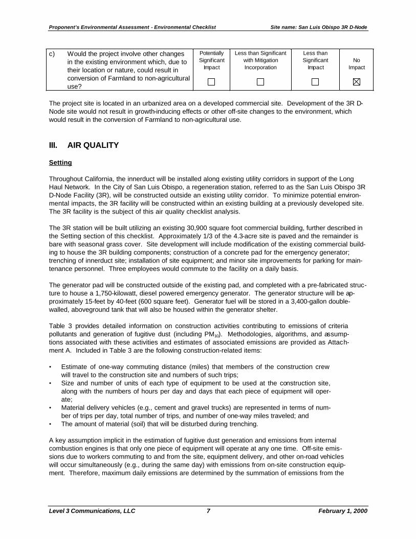
c) Would the project involve other changes in the existing environment which, due to their location or nature, could result in conversion of Farmland to non-agricultural use?
Potentially Significant
Impact
Less than Significant with Mitigation Incorporation
Less than Significant
Impact
No
Impact
The project site is located in an urbanized area on a developed commercial site. Development of the 3R D-Node site would not result in growth-inducing effects or other off-site changes to the environment, which would result in the conversion of Farmland to non-agricultural use. III. AIR QUALITY Setting Throughout California, the innerduct will be installed along existing utility corridors in support of the Long Haul Network. In the City of San Luis Obispo, a regeneration station, referred to as the San Luis Obispo 3R D-Node Facility (3R), will be constructed outside an existing utility corridor. To minimize potential environ-mental impacts, the 3R facility will be constructed within an existing building at a previously developed site. The 3R facility is the subject of this air quality checklist analysis. The 3R station will be built utilizing an existing 30,900 square foot commercial building, further described in the Setting section of this checklist. Approximately 1/3 of the 4.3-acre site is paved and the remainder is bare with seasonal grass cover. Site development will include modification of the existing commercial build-ing to house the 3R building components; construction of a concrete pad for the emergency generator; trenching of innerduct site; installation of site equipment; and minor site improvements for parking for main-tenance personnel. Three employees would commute to the facility on a daily basis. The generator pad will be constructed outside of the existing pad, and completed with a pre-fabricated struc-ture to house a 1,750-kilowatt, diesel powered emergency generator. The generator structure will be ap-proximately 15-feet by 40-feet (600 square feet). Generator fuel will be stored in a 3,400-gallon double-walled, aboveground tank that will also be housed within the generator shelter. Table 3 provides detailed information on construction activities contributing to emissions of criteria pollutants and generation of fugitive dust (including PM10). Methodologies, algorithms, and assump-tions associated with these activities and estimates of associated emissions are provided as Attach-ment A. Included in Table 3 are the following construction-related items:
• Estimate of one-way commuting distance (miles) that members of the construction crew
will travel to the construction site and numbers of such trips; • Size and number of units of each type of equipment to be used at the construction site,
along with the numbers of hours per day and days that each piece of equipment will oper-ate;
• Material delivery vehicles (e.g., cement and gravel trucks) are represented in terms of num-ber of trips per day, total number of trips, and number of one-way miles traveled; and
• The amount of material (soil) that will be disturbed during trenching. A key assumption implicit in the estimation of fugitive dust generation and emissions from internal combustion engines is that only one piece of equipment will operate at any one time. Off-site emis-sions due to workers commuting to and from the site, equipment delivery, and other on-road vehicles will occur simultaneously (e.g., during the same day) with emissions from on-site construction equip-ment. Therefore, maximum daily emissions are determined by the summation of emissions from the

Proponent’s Environmental Assessment - Environmental Checklist Site name: San Luis Obispo 3R D-Node
Level 3 Communications, LLC 8 February 1, 2000
highest emitting piece of construction equipment and on-road emissions that occur on the same day as that piece of construction equipment is operating. Operational parameters specified in Table 3 include specification of the 1,750 kW standby generator, ap-proximate 30-minute weekly testing (conservatively estimated as 30 hours/year for emissions estimation), and parameters for the daily commuting employee vehicles. Operating equipment at the site will be pow-ered by electricity from the utility power grid, and the weekly test of the generator will be triggered automati-cally. Table 3 shows the emission factors and other parameters used to calculate exhaust and fugitive PM10 emis-sions for mobile equipment (U.S. EPA, 1996). Also included in Table 3 are de minimis construction emis-sion thresholds established by the San Luis Obispo County Air Pollution Control District, (SLOCAPCD) (SLOCAPCD, 1995), which is responsible for management of air emissions in San Luis Obispo County. Construction and operation emission thresholds are provided for NOx, ROG, and PM10; none exist for sulfur oxides (SOx) and carbon monoxide (CO). In San Luis Obispo County, the PM10 threshold addresses the combined exhaust and fugitive dust emissions from construction activities. Emission rates below these thresholds are considered less than significant by the SLOCAPCD. San Luis Obispo County is located within the South Central Coast Air Basin, which also includes Santa Barbara and Ventura Counties. The South Central Coast Air Basin is currently designated as a nonattain-ment area for state ozone and PM10 standards (California EPA, 1998), but is considered an attainment area for the National Ambient Air Quality Standard. According to monitoring data collected during the three-year period 1995 to 1997 at monitoring stations in San Luis Obispo County, maximum ozone concentrations rarely exceeded the national ozone standard (0.12 parts per million, one-hour average). However, the more stringent state ozone standard (0.09 parts per million; one-hour average) is exceeded an average of approximately 7 days per year (California EPA, 1996-1998). Ozone levels in San Luis Obispo County reflects emissions sources within the South Central Coast Air Basin, but under certain meteorological conditions, the ozone levels are affected by the transport of pol-lutants from the San Joaquin Valley Air Basin. Based on PM10 data from the closest monitoring station, which is in the City of San Luis Obispo, ambient PM10 concentrations in the project vicinity do not approach the National Ambient Air Quality 24-hour-average standard of 150 micrograms per cubic meter (ug/m3) and rarely exceed (approximately two percent of the time) the more stringent California Ambient Air Quality Standard of 50 ug/m3 (California EPA, 1996-1998). The PM10 nonattainment in San Luis Obispo County is influenced by pollutant transport, but also by such local sources as travel over paved and unpaved roads, construction activities, and farming operations. The California Clean Air Act requires plans to be developed for areas designated as nonattainment, except of the state PM10 standard. Such plans are to include strategies for attaining the standards. The current ozone “attainment” plan for San Luis Obispo County is the 1998 Clean Air Plan (SLOCAPCD, 1998). This plan relies on emissions control measures, some of which are implemented at the state and federal levels. Generally, stationary source control measures are implemented by the air district, while mobile and area source control measures are implemented at the state level by the Air Resources Board and at the federal level by the U.S. Environmental Protection Agency (U.S. EPA). SLOCAPCD provides guidelines to lead agencies in determining whether a project would be likely to exceed an air quality standard or contribute substantially to an existing or projected exceedance. The CEQA-related emission thresholds for construction are shown in Table 3, below which potential impacts are judged to be insignificant. All are expressed on a daily basis in terms of pounds per day, except PM10. For evaluating construction-phase air quality impacts, SLOCAPCD recommends use of emissions-based significance criteria of 185 pounds per day (lb/day) for reactive organic gases (ROG) and NOx, and 2.5 tons per quarter (tpq) of PM10 (SLOCAPCD, 1995). The PM10 threshold includes both engine exhaust and fugitive dust sources.
Proponent’s Environmental Assessment - Environmental Checklist Site name: San Luis Obispo 3R D-Node
Level 3 Communications, LLC 9 February 1, 2000
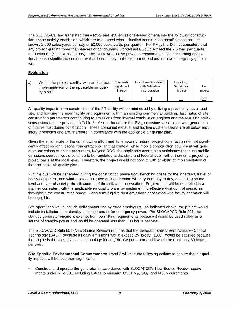
The SLOCAPCD has translated these ROG and NOX emissions-based criteria into the following construc-tion-phase activity thresholds, which are to be used where detailed construction specifications are not known: 2,000 cubic yards per day or 50,000 cubic yards per quarter. For PM10, the District considers that any project grading more than 4-acres of continuously worked area would exceed the 2.5 tons per quarter (tpq) criterion (SLOCAPCD, 1995). The SLOCAPCD also provides recommendations concerning opera-tional-phase significance criteria, which do not apply to the exempt emissions from an emergency genera-tor. Evaluation a) Would the project conflict with or obstruct
implementation of the applicable air qual-ity plan?
Potentially Significant
Impact
Less than Significant with Mitigation Incorporation
Less than Significant
Impact
No
Impact
Air quality impacts from construction of the 3R facility will be minimized by utilizing a previously developed site, and housing the main facility and equipment within an existing commercial building. Estimates of site construction parameters contributing to emissions from internal combustion engines and the resulting emis-sions estimates are provided in Table 3. Also included are the PM10 emissions associated with generation of fugitive dust during construction. These combined exhaust and fugitive dust emissions are all below regu-latory thresholds and are, therefore, in compliance with the applicable air quality plan.
Given the small scale of the construction effort and its temporary nature, project construction will not signifi-cantly affect regional ozone concentrations. In that context, while mobile construction equipment will gen-erate emissions of ozone precursors, NOx and ROG, the applicable ozone plan anticipates that such mobile emissions sources would continue to be regulated at the state and federal level, rather than on a project-by-project basis at the local level. Therefore, the project would not conflict with or obstruct implementation of the applicable air quality plan.
Fugitive dust will be generated during the construction phase from trenching onsite for the innerduct, travel of heavy equipment, and wind erosion. Fugitive dust generation will vary from day to day, depending on the level and type of activity, the silt content of the soil, and the weather. Fugitive dust will be controlled in a manner consistent with the applicable air quality plans by implementing effective dust control measures throughout the construction phase. Long-term fugitive dust emissions associated with facility operation will be negligible.
Site operations would include daily commuting by three employees. As indicated above, the project would include installation of a standby diesel generator for emergency power. Per SLOCAPCD Rule 201, the standby generator engine is exempt from permitting requirements because it would be used solely as a source of standby power and would be operated less than 100 hours per year.
The SLOAPACD Rule 601 (New Source Review) requires that the generator satisfy Best Available Control Technology (BACT) because its daily emissions would exceed 25 lb/day. BACT would be satisfied because the engine is the latest available technology for a 1,750 kW generator and it would be used only 30 hours per year.
Site-Specific Environmental Commitments: Level 3 will take the following actions to ensure that air qual-ity impacts will be less than significant: • Construct and operate the generator in accordance with SLOCAPCD’s New Source Review require-
ments under Rule 601, including BACT to minimize CO, PM10, SOX, and NOX requirements.

Proponent’s Environmental Assessment - Environmental Checklist Site name: San Luis Obispo 3R D-Node
Level 3 Communications, LLC 10 February 1, 2000
b) Would the project violate any air quality standard or contribute substantially to an existing or projected air quality violation?
Potentially Significant
Impact
Less than Significant With Mitigation Incorporation
Less than Significant
Impact
No
Impact
As discussed above, the project site lies in an area designated as “nonattainment” for the state ambient air quality standards for ozone and PM10.
SLOCAPCD provides threshold rates to determine the potential significance of emissions associated with individual development projects (Table 3). These thresholds pertain to emissions from both internal combus-tion engines and fugitive dust generated during construction. For ROG and NOx, the criterion is 185 lb/day, while that for PM10 is 2.5 tpq. There are no thresholds for SOX, and CO. Total construction-phase engine emissions and fugitive dust emissions (Table 3) are less than regulatory thresholds and, therefore, are less than significant. Even though PM10 emissions would be below the appli-cable SLOCAPCD significance threshold, fugitive dust control measures would be implemented during con-struction. Level 3 would implement a comprehensive series of dust control measures to manage fugitive dust during construction, reducing the associated PM10 emissions further below the level of significance.
Over the long-term, the project would result in emissions from operation of both stationary and mobile sources (Table 3). Mobile source emissions from three commuting vehicles would be small. Stationary source emissions would result from operation of the emergency, diesel-powered, standby engine during rou-tine weekly testing and power outages. Daily emissions estimates and annual estimates for operation of the proposed 1,750 kW emergency standby engine are shown in Table 3. Because the generator will operate less than 100 hours per year, it is exempt from compliance with numerical thresholds, such as those associated with offset requirements. Additional ROG emissions from the aboveground diesel storage tank will be negligible because of its integral construction, infrequent filling, and strict adherence to procedures to avoid spillage during tank filling. Site Specific Environmental Commitments: Level 3 would implement a construction-phase dust abate-ment program, including the following activities:
• Dust emissions from all disturbed areas, including storage piles that are not being actively utilized for
construction purposes, will be effectively stabilized using water, chemical stabilizer or suppressant or vegetative cover;
• Dust emissions from all on-site unpaved roads and off-site unpaved access roads will be effectively sta-bilized using water or chemical stabilizer or suppressant;
• Fugitive dust emissions from all land-clearing, grubbing, scraping, excavation, land-leveling, grading, cut and fill, and demolition activities will be effectively controlled by watering during these activities or pre-soaking;
• When materials are transported off-site, all material will be covered, effectively wetted to limit visible dust emissions, or kept below at least six inches of freeboard space from the top of the container; and
• All operations will limit or expeditiously remove the accumulation of mud or dirt from adjacent public streets at least once every 24 hours when operations are occurring. Dry rotary brushes will not be used except when preceded or accompanied by sufficient wetting to limit the visible dust emissions. Blower devices will not be used.
Implementation of the above measures would assure compliance with fugitive dust PM10 standards, keep PM10 concentrations in the vicinity of the project alignment below standards would be violated in the vicinity of the project alignment, protect visibility during the construction period, and limit generation of significant emissions of ozone precursors. In summary, the project construction and operations activities would com-

Proponent’s Environmental Assessment - Environmental Checklist Site name: San Luis Obispo 3R D-Node
Level 3 Communications, LLC 11 February 1, 2000
ply with air quality standards, and will not contribute substantially to an existing or projected air quality viola-tion. c) Would the project result in a cumulatively
considerable net increase of any criteria pollutant for which the project region is non-attainment under an applicable fed-eral and state ambient air quality stan-dard (including releasing emissions which exceed quantitative thresholds for ozone precursors)?
Potentially Significant
Impact
Less than Significant With Mitigation Incorporation
Less than Significant
Impact
No
Impact
The 3R site is one of two PEA sites located in San Luis Obispo County. The other site is the Cuesta Grade Workaround. Potential total construction emissions from both sites were analyzed for the possibility of si-multaneous construction. The same thresholds apply to assessment of total project emissions as were used to evaluate emissions from individual project sites. Ozone impacts are the result of the cumulative emissions from numerous sources in the region and trans-port from outside the region. Although San Luis Obispo County is a nonattainment area for ozone and PM10 standards, the project’s incremental contribution from both PEA sites to regional emissions is too small to be cumulatively considerable. Because project construction, except for trenching and grading to prepare the emergency generator enclo-sure, will take place within existing buildings, surrounding areas will be buffered from the effects of project construction (Figure 7, Conceptual Plot Plan). This buffer will help minimize the possibility that the project will cause a cumulatively significant short-term PM10 impact from simultaneous and unrelated construction projects taking place within the same general area. Since the other PEA site in SLOCAPCD (the Cuesta Grade Workaround) has no generator or other source of operational emissions, the project emissions from testing and maintaining the emergency generator at the 3R site already represent the total project operational emissions. Since the generator is exempt from regu-latory requirements, total project emission impacts are less than significant. d) Would the project expose sensitive recep-
tors to substantial pollutant concentra-tions?
Potentially Significant
Impact
Less than Significant With Mitigation Incorporation
Less than Significant
Impact
No
Impact
Sensitive receptors are defined as facilities that house children, elderly and ill members of the population, such as schools, daycare centers, hospitals, retirement homes, hospices and residences. The nearest neighbors to the 3R facility are industrial buildings, which do not qualify as sensitive receptors. The nearest sensitive receptors are residences located approximately 140 feet to the southwest, as shown on Figure 8. However, the generator is setback at least 180 feet from the southwest property line, providing a total set-back of 320 feet from the nearest sensitive receptor. Using the same general line of reasoning, the nearest public receptor is 150 feet away (100 foot generator setback plus 50 feet from the property line to the near-est public receptor). During construction, site access will be easy and direct. Construction vehicles will not block traffic on adja-cent roadways for any significant period of time. Thus, emissions from idling vehicles in the vicinity of any sensitive receptors will be infrequent and minimal. The emergency generator will produce operation emissions during testing and power outages. Two factors prevent these emissions from significantly affecting sensitive receptors. First, the generator will located at

Proponent’s Environmental Assessment - Environmental Checklist Site name: San Luis Obispo 3R D-Node
Level 3 Communications, LLC 12 February 1, 2000
least 320 feet from the nearest sensitive receptor. Second, generator usage will be restricted to one-half hour per week and not more than 30 hours per year. These measures will assure that sensitive receptors are not exposed to substantial pollutant concentrations. e) Would the project create objectionable
odors affecting a substantial number of people?
Potentially Significant
Impact
Less than Significant with Mitigation Incorporation
Less than Significant
Impact
No
Impact
The only odors that may be associated with site construction activities at the facility will be from burning of diesel fuel in the engines powering the construction equipment and gasoline in the vehicles of site construc-tion workers. Construction-related odors will not affect the public given the short-term nature of construction and the commercial/industrial site setting. Similarly, testing of the emergency generator at the 3R site for no more than one half hour per week will not produce sufficient exhaust or odor to be objectionable to a sub-stantial number of people. IV. BIOLOGICAL RESOURCES Setting
The majority of the proposed site has been disturbed due to previous grading and commercial development with over a third of the site under pavement. A perennial stream with wetland and riparian components is located along the eastern and southern property limits. Plant species observed in disturbed areas included wild oats (Avena sp.), black mustard (Brassica nigra), red brome (Bromus rubens), fennel (Foeniculum vulgare), acacia, and eucalyptus. Plant species observed in wetland and riparian areas included red willow (Salix sp.), curly dock (Rumex crispus), sedge (Scirpus sp.), rush (Juncus sp.), and blackberry (Rubus ursinus). Observed wildlife species included California tree frog (Hyla cadaverina), mourning dove (Zenaida macroura), common raven (Corvus corax), and house finch (Carpodacus mexicanus). Evaluation a) Would the project have a substantial ad-
verse effect, either directly or through habitat modifications, on any species identified as a candidate, sensitive, or special status species in local or regional plans, policies, or regulations, or by the California Department of Fish and Game or U.S. Fish and Wildlife Service?
Potentially Significant
Impact
Less than Significant with Mitigation Incorporation
Less than Significant
Impact
No
Impact
The project site consists of an existing structure, previously used as a grocery store. The majority of con-struction activities associated with the project are expected to be contained within the existing structure. Therefore, it is highly unlikely that there will be any adverse impact to sensitive or special status species. An inclusive search, the California Natural Diversity Database (San Luis Obispo Quadrangle) was performed for sensitive plant and wildlife species with the potential to occur in the vicinity of the project site California Department of Fish and Game, September 1999). The occurrence potentials for all sensitive species re-vealed in this search are included in Table 5. Based on the on-site evaluation and the consultation with the City of San Luis Obispo, the California red-legged frog (Rana aurora draytonii, federally threatened and a California Species of Special Concern) has the potential to occur in the perennial stream located along the
Proponent’s Environmental Assessment - Environmental Checklist Site name: San Luis Obispo 3R D-Node
Level 3 Communications, LLC 13 February 1, 2000
eastern and southern property limits. Since all construction activities are to be contained within previously developed areas, no impact to this species is expected ensue (California Department of Fish and Game, September 1999; Condron, 1999). Site-Specific Environmental Commitments: Due to the proximity of the stream to the project site, it is recommended that biological monitors be present during construction activities occurring outside the con-fines of the existing structure. The City of San Luis Obispo also enforces a “Creek Setback Ordinance” that requires a buffer of at least 20 feet between any construction activity and the edge of the drainage bank or riparian vegetation. Sufficient erosion control devices will be installed to ensure that there will be no impact to any wetland or aquatic resources. An environmental monitor will be present to ensure that the setback ordinance and erosion control devices are implemented properly. b) Would the project have a substantial ad-
verse effect on any riparian habitat or other sensitive natural community identi-fied in local or regional plans, policies, regulations or by the California Depart-ment of Fish and Game or U.S. Fish and Wildlife Service?
Potentially Significant
Impact
Less than Significant with Mitigation Incorporation
Less than Significant
Impact
No
Impact
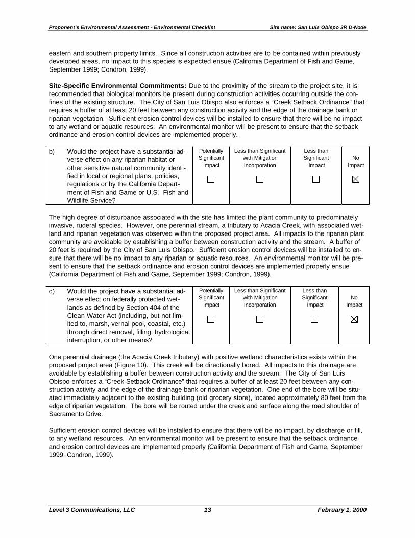
The high degree of disturbance associated with the site has limited the plant community to predominately invasive, ruderal species. However, one perennial stream, a tributary to Acacia Creek, with associated wet-land and riparian vegetation was observed within the proposed project area. All impacts to the riparian plant community are avoidable by establishing a buffer between construction activity and the stream. A buffer of 20 feet is required by the City of San Luis Obispo. Sufficient erosion control devices will be installed to en-sure that there will be no impact to any riparian or aquatic resources. An environmental monitor will be pre-sent to ensure that the setback ordinance and erosion control devices are implemented properly ensue (California Department of Fish and Game, September 1999; Condron, 1999). c) Would the project have a substantial ad-
verse effect on federally protected wet-lands as defined by Section 404 of the Clean Water Act (including, but not lim-ited to, marsh, vernal pool, coastal, etc.) through direct removal, filling, hydrological interruption, or other means?
Potentially Significant
Impact
Less than Significant with Mitigation Incorporation
Less than Significant
Impact
No
Impact
One perennial drainage (the Acacia Creek tributary) with positive wetland characteristics exists within the proposed project area (Figure 10). This creek will be directionally bored. All impacts to this drainage are avoidable by establishing a buffer between construction activity and the stream. The City of San Luis Obispo enforces a “Creek Setback Ordinance” that requires a buffer of at least 20 feet between any con-struction activity and the edge of the drainage bank or riparian vegetation. One end of the bore will be situ-ated immediately adjacent to the existing building (old grocery store), located approximately 80 feet from the edge of riparian vegetation. The bore will be routed under the creek and surface along the road shoulder of Sacramento Drive. Sufficient erosion control devices will be installed to ensure that there will be no impact, by discharge or fill, to any wetland resources. An environmental monitor will be present to ensure that the setback ordinance and erosion control devices are implemented properly (California Department of Fish and Game, September 1999; Condron, 1999).

Proponent’s Environmental Assessment - Environmental Checklist Site name: San Luis Obispo 3R D-Node
Level 3 Communications, LLC 14 February 1, 2000
d) Would the project interfere substantially with the movement of any native resident or migratory fish or wildlife species or with established native resident or migratory wildlife corridors, or impede the use of na-tive wildlife nursery sites?
Potentially Significant
Impact
Less than Significant with Mitigation Incorporation
Less than Significant
Impact
No
Impact
Adjacent commercial development and roads create an isolating boundary around this site. It is therefore unlikely that the site functions as an important link in any terrestrial wildlife corridor. Given the high degree of disturbance throughout the majority of the site, it is also unlikely that the property would provide nursery habitat for any native terrestrial species. The existing drainage may provide suitable habitat for the southern steelhead trout, a native fish species that utilizes freshwater stream habitats for seasonal migration. All impacts to the aquatic habitat are avoidable by establishing a construction buffer and installing sufficient erosion control devices between construction activity and the stream. An environmental monitor will be pre-sent to ensure that the setback ordinance and erosion control devices are implemented properly (California Department of Fish and Game, September 1999; Condron, 1999). e) Would the project conflict with any local
policies or ordinances protecting biologi-cal resources, such as a tree preservation policy or ordinance?
Potentially Significant
Impact
Less than Significant w ith Mitigation Incorporation
Less than Significant
Impact
No
Impact
The project will not conflict with any local policies or ordinances protecting biological resources. The city of San Luis Obispo requires a permit for the removal of any tree, native or nonnative, greater than 4 feet in height. However, the proposed project will not require the removal of any tree species (California Department of Fish and Game, September 1999; Condron, 1999). f) Would the project conflict with the provi-
sions of an adopted Habitat Conservation Plan, Natural Community Conservation Plan, or other approved local, regional, or state habitat conservation plan?
Potentially Significant
Impact
Less than Significant with Mitigation Incorporation
Less than Significant
Impact
No
Impact
The project will not conflict with the provisions of any adopted Habitat Conservation Plan, Natural Community Conservation Plan, or other approved local, regional, or state habitat conservation plan (California Depart-ment of Fish and Game, September 1999; Condron, 1999). V. CULTURAL RESOURCES Setting
The 3R facility site is in the southern part of San Luis Obispo on the southwest corner of Capitolio Way and Sacramento Drive. There is an abandoned grocery store on the parcel, which will house the proposed facil-ity. Part of the parcel around the building is paved and the rest is open ground.
The project area is located in the region occupied by the Chumash when the first Spanish land expedition passed through the area in A.D. 1769. Most ethnohistoric and archaeological research in Chumash terri-tory has taken place along the Santa Barbara Channel coast and the following prehistoric setting is based on a summary of this research. King (1981) has divided the prehistory of the Santa Barbara Channel region into three periods: Early (8000 to

Proponent’s Environmental Assessment - Environmental Checklist Site name: San Luis Obispo 3R D-Node
Level 3 Communications, LLC 15 February 1, 2000
3350 B.P.), Middle (3350 to 800 B.P.), and Late (800 to 150 B.P.). King's chronology is based on stylistic changes in beads and ornaments from burial assemblages. The artifact types, which indicate temporal af-filiation, are seldom found in quantity outside of cemeteries, limiting the usefulness of the chronology for dating components at other kinds of sites. However, the chronology can be tied to absolute dates through radiocarbon dating. Dates for the beginning and end of each of King's periods are based on radiocarbon dates from burial assemblages (King, 1981). The Early Period has been divided into three phases, X, Y, and Z, with a gap in time between Phases X and Y. The X Phase of the Early Period, which precedes the peak of the warm dry climatic period known as the Altithermal, is characterized by the use of large flake and core tools and millingstones and handstones. The millingstones indicate the grinding of hard seeds, probably gathered from sage (Salvia) plants. Mortars and pestles, which indicate acorn grinding, were not widely used until the beginning of Phase Y after the peak of the Altithermal (Glassow, Wilcoxon, and Erlandson, 1988:8). Evidence for sea mammal procurement also begins at this time. It is possible that this increase in diet breadth may be related to a population increase associated with the end of peak Altithermal conditions (Glassow, Wilcoxon, and Erlandson, 1988). Evi-dence useful for reconstructing settlement patterns during the Early Period is extremely limited. Based on these limited data, King (1981) suggests that Phase X sites along the Santa Barbara Channel were located on crests of hills away from the ocean but some Phase Y sites were located on knolls adjacent to sloughs. During Phase Z King notes that sites were again located on higher ground. All Early Period sites investi-gated appear to be base camps, but it is likely that temporary camps also existed. During the Middle Period (3350 to 800 B.P.) increasing sedentism and increasing emphasis on marine sub-sistence along the Santa Barbara Channel is reflected by the appearance of coastal villages occupied during a large part of the year. Circular shell fishhooks supplement the bone gorges and compound fishhooks which came into use during the Early Period (Tartaglia, 1976). The plank canoe, which made ocean fishing and travel to the Channel Islands safer and more efficient, came into use about 1500 B.P. (Arnold 1987:7). Use of the plank canoe also promoted trade and exchange between the mainland and the Channel Islands. Terrestrial hunting is indicated by use of contracting stemmed and corner-notched dart points (used with spear throwers). Increasing status differentiation is reflected by differences in amounts of beads and other ornaments associated with burials (Martz,1987). The full development of Chumash culture, one of the most socially and economically complex hunting and gathering groups in North America (Arnold 1987:4), occurred during the Late Period (800 to 150 B.P. or ap-proximately A.D. 1150 to 1800). Along the Santa Barbara Channel and on the Channel Islands there were a series of permanent or semi-permanent villages with populations of 200 to 600 or more individuals (Grant, 1978b). The principal economic pursuits were marine fishing and trading. Status differentiation had devel-oped to the point where village chiefs inherited their rank and probably controlled trade and redistribution. Only certain higher ranking lineages built and operated plank canoes. Trade and redistribution of products from different environmental zones was facilitated by the use of shell bead "money," made almost exclu-sively on the Channel Islands. Making microdrills (used to make beads) from island chert sources was a specialized industry (Arnold, 1987:247). Chumash Channel-area villages contained circular houses made of willow poles and thatch. A hearth was located in the center of each house. In addition to houses, each village contained a sweat house, a sacred council chamber, a dance floor, and a cemetery (Rogers, 1929). Terrestrial animals were hunted using the bow and arrow, indicated by the presence of projectile points weighing less than 3.5 grams (Fenenga, 1953). Acorns continued to be harvested and were processed us-ing stone mortars and pestles. Acorns were a storable resource, which when combined with marine fishing, probably allowed a greater degree of sedentism to develop. Ornaments and beads were probably made by specialists and were used to reinforce status differences. They also played an important role in facilitating redistribution and exchange. When the Spanish arrived in A.D. 1769 the Chumash occupied the coast from Malibu Canyon to San Luis Obispo and inland as far as the western edge of the San Joaquin Valley (Grant, 1978a). The Chumash were divided into several language or dialect groups that corresponded with territory around the missions founded

Proponent’s Environmental Assessment - Environmental Checklist Site name: San Luis Obispo 3R D-Node
Level 3 Communications, LLC 16 February 1, 2000
by the Spanish. From south to north along the coast, there were the Ventureño around San Buenaventura Mission (now in Ventura), the Barbareño around Santa Barbara Mission, the Purismeño around La Purisima Concepción Mission (near Lompoc), and the Obispeño around San Luis Obispo Mission. These missions were founded between 1772 and 1788. The Cuyama, Emigdiano, and Castac were inland Chumash who lived where no missions were founded. The northern Channel Islands were also inhabited by Chumash. The missionaries began a program of converting the Chumash to Christianity, baptizing them, and moving them into the missions. Here they were taught farming and European crafts. By 1804, most villages were abandoned and most Chumash lived at the missions. Unfortunately, the congregation of the population at the missions exposed them to European diseases to which the Native Americans had no resistance (Grant, 1978a). At La Purisima Mission, the Native American population declined from 1,520 in 1804 to approximately 400 in 1832 (Greenwood, 1978:521). Mission San Luis Obispo de Tolosa was founded in what is now the town of San Luis Obispo in 1772. Cali-fornia became part of Mexico when Mexico gained its independence from Spain in 1822. Mission life ended when the missions and their lands were secularized by the Mexican government in 1834. Former mission lands were granted to soldiers and other Mexican citizens for use as cattle ranches. Ranching continued during the American period that began when the Treaty of Guadalupe Hidalgo was signed between Mexico and the United States in 1848. The Gold Rush of 1849 created a market for beef shipped from the southern California cattle ranches to northern California. Ranches in the area were purchased by Anglo Americans in the 1870s and converted to sheep ranches. The Southern Pacific Railroad was completed along the coast by 1901, resulting in increased settlement and agricultural production around San Luis Obispo. Evaluation a) Would the project cause a substantial
adverse change in the significance of a historical resource as defined in §15064.5?
Potentially Significant
Impact
Less than Significant with Mitigation Incorporation
Less than Significant
Impact
No
Impact
The protocols contained in Level 3’s Long Haul Fiber Optics Project Cultural Resources Procedures (Par-sons Brinckerhoff Network Services, 1999), requiring records searches and field survey, where appropriate, will be followed as summarized below. A technical report, providing more information on the results of the records search and field survey has been prepared (Mason 1999). Prior to the commencement of fieldwork, Level 3 archaeologists requested a records search for the proposed San Luis Obispo 3R D-Node, and the lands within a one-mile radius, from the California Historical Re-sources Central Coastal Information Center located at the University of California, Santa Barbara (March 9, 1999). The search had two objectives: (1) to determine whether previous archaeological investigations have been conducted in the project area, and (2) to provide information on known historic sites or culturally sensi-tive areas on and in the vicinity of the proposed 3R D-Node. The records search from the Central Coastal Information Center was conducted by Information Center staff who also checked the California Office of His-toric Preservation (OHP) Historic Property Data File for San Luis Obispo County, which includes the Na-tional Register of Historic Places (listings and eligibility determinations), California Points of Historical Inter-est, and California Historical Landmarks. In addition, the Level 3 Team sent a letter dated September 3, 1999 to the Native American Heritage Com-mission (NAHC) requesting a search of the NAHC Sacred Lands file and identification of a contact person or persons within NAHC for follow-on contact/consultation (Mason, 1999a). The response, dated September 17, 1999, indicated that the NAHC search revealed no site-specific information on Sacred Lands (McNulty, 1999). The letter cautioned that absence of information did not necessarily indicate the absence of cultural resources. A list of Native American contacts that might serve as sources of additional information was also provided. Level 3 has followed up on this response from NAHC by sending letters to NAHC-identified Native

Proponent’s Environmental Assessment - Environmental Checklist Site name: San Luis Obispo 3R D-Node
Level 3 Communications, LLC 17 February 1, 2000
American contacts residing in San Luis Obispo County, notifying them of the Level 3 project activities and requesting information they might have on sacred lands. Any response indicating the possible presence of Sacred Lands will be followed up with a detailed, site-specific evaluation utilizing the expertise of the relevant Native American contacts. The results of this effort are fully documented, as appropriate, in the supporting technical report (Mason, 1999b). The results of the records search (No file number assigned) showed that the parcel had not been previously surveyed for historic resources (California Historical Resources Information System Central Coastal Center, 1999). A field survey showed that there are no historic resources that are potentially eligible for the Califor-nia Register of Historic Resources present on the property (Carbone, 1999). The structure on the project parcel is not eligible for the California Register of Historical Resources. It is not associated with significant historic events or important persons, does not have distinctive architectural characteristics, nor does it have the potential to yield information important in history. In addition, the structure is less than 50 years old. b) Would the project cause a substantial
adverse change in the significance of an archaeological resource pursuant to §15064.5?
Potentially Significant
Impact
Less than Significant with Mitigation Incorporation
Less than Significant
Impact
No
Impact
The records search from the Central Coastal Information Center showed that the parcel had not been previ-ously surveyed for archaeological resources. A field survey showed that there is an archaeological site lo-cated in the adjacent parcel to the west of the proposed facility site. Cultural material observed on the site includes debitage (waste flakes from making or maintaining flaked stone tools), fire-affected rock, at least four species of marine shell, and calcined animal bone. Since subsurface cultural material could extend into the proposed project parcel from the site identified on the surface in the adjacent parcel, an archaeological test program (Shepard, 1999) consisting of the excava-tion of shovel test probes was performed within the two alternative proposed cable alignments and in all loca-tions where landscape trees are proposed to be planted within the parcel. As the 3R Facility will be con-structed within the existing building on the parcel, the only potential project related impacts would result from trenching for fiber optic cable installation to and from the facility and the planting of large trees. No cultural material was recovered from any of the shovel test probes. Therefore, it is apparent that the site does not extend onto the current project parcel. A data recovery program is not necessary because no evi-dence of an archaeological site was found to exist within the project parcel. c) Would the project directly or indirectly de-
stroy a unique paleontological resource or site or unique geological feature?
Potentially Significant
Impact
Less than Significant with Mitigation Incorporation
Less than Significant
Impact
No
Impact
As mapped by Jennings (1958), the project site is underlain by Jurassic and Cretaceous metamorphic rocks of the Franciscan Formation (unit KJf). The Franciscan Formation has yielded fossil remains presumably of a marine vertebrate at University of California Museum of Paleontology (UCMP) fossil site V-4958 elsewhere in San Luis Obispo County. This fossil occurrence suggests that there is a potential for Mesozoic and Ce-nozoic marine invertebrate and vertebrate fossil remains being encountered by construction-related earth moving at the project site. Site Specific Environmental Commitments: Proponent, as part of the project design, has committed to archaeological/paleontological monitoring during construction. Monitoring would be by a qualified vertebrate paleontologist or a qualified paleontologic construction monitor to allow for the recovery of larger fossil re-mains at newly discovered fossil sites, and a small rock sample should be submitted for microfossil analy-
Proponent’s Environmental Assessment - Environmental Checklist Site name: San Luis Obispo 3R D-Node
Level 3 Communications, LLC 18 February 1, 2000
sis. All recovered fossil remains should be fully treated (prepared, identified by knowledgeable paleontolo-gists, curated, catalogued) and, along with associated specimen data and corresponding geologic and geo-graphic site data, placed in a recognized museum repository. The paleontologist will prepare a final report of findings that includes an inventory of recovered fossil remains. These measures would be in compliance with Society of Vertebrate Paleontology (1995, 1996) guidelines for the management of paleontologic re-sources and for the museum acceptance of a monitoring program fossil collection. d) Would the project disturb any human re-
mains, including those interred outside of formal cemeteries?
Potentially Significant
Impact
Less than Significant with Mitigation Incorporation
Less than Significant
Impact
No
Impact
The records search and field survey provided no evidence of the presence of human remains (California His-torical Resources Information System, Central Coastal Center, 1999; Carbone, 1999). If suspected human remains are encountered during construction, operations will stop until the proper official will be notified, the find evaluated, any mitigation recommendations implemented, and Level 3 has been cleared to resume con-struction in the area of the find. The procedures to be followed are described in detail in Level 3’s Long-Haul Fiber Optics Project Cultural Resources Procedures (Parsons Brinckerhoff Network Services, 1999:25-39), approved by the California Public Utilities Commission (CPUC).
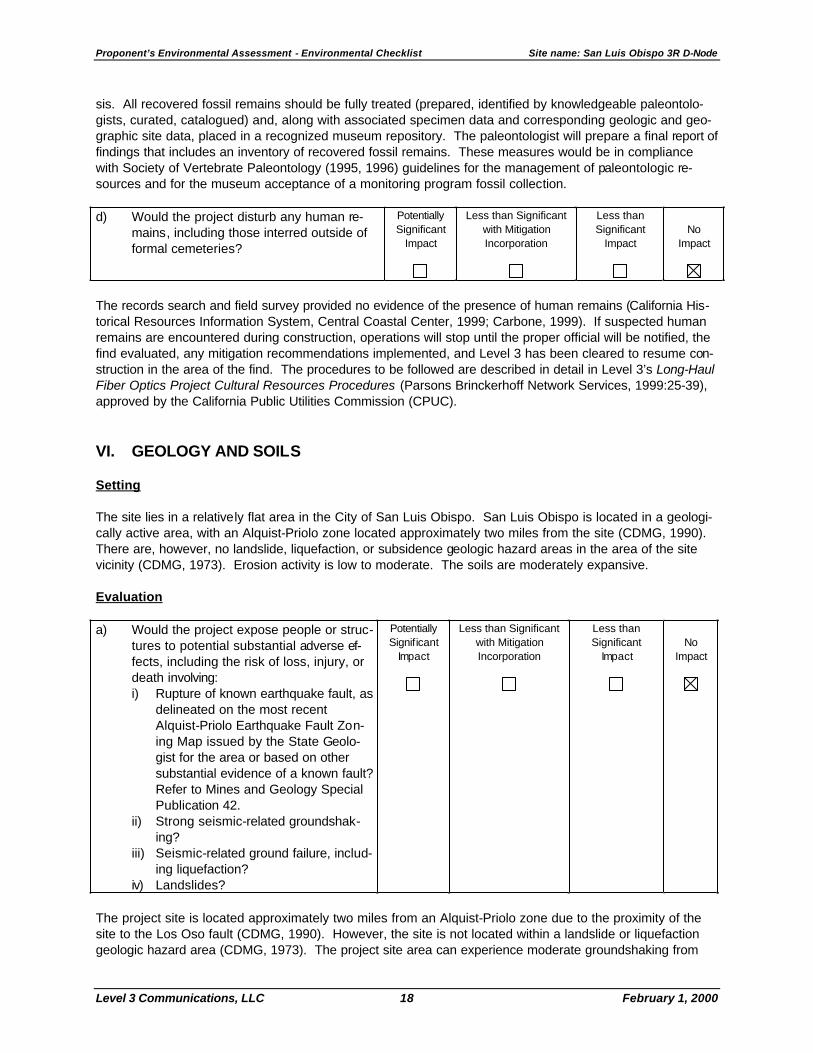
VI. GEOLOGY AND SOILS Setting The site lies in a relatively flat area in the City of San Luis Obispo. San Luis Obispo is located in a geologi-cally active area, with an Alquist-Priolo zone located approximately two miles from the site (CDMG, 1990). There are, however, no landslide, liquefaction, or subsidence geologic hazard areas in the area of the site vicinity (CDMG, 1973). Erosion activity is low to moderate. The soils are moderately expansive. Evaluation a) Would the project expose people or struc-
tures to potential substantial adverse ef-fects, including the risk of loss, injury, or death involving: i) Rupture of known earthquake fault, as
delineated on the most recent Alquist-Priolo Earthquake Fault Zon-ing Map issued by the State Geolo-gist for the area or based on other substantial evidence of a known fault? Refer to Mines and Geology Special Publication 42.
ii) Strong seismic-related groundshak-ing?
iii) Seismic-related ground failure, includ-ing liquefaction?
iv) Landslides?
Potentially Significant
Impact
Less than Significant with Mitigation Incorporation
Less than Significant
Impact
No
Impact
The project site is located approximately two miles from an Alquist-Priolo zone due to the proximity of the site to the Los Oso fault (CDMG, 1990). However, the site is not located within a landslide or liquefaction geologic hazard area (CDMG, 1973). The project site area can experience moderate groundshaking from

Proponent’s Environmental Assessment - Environmental Checklist Site name: San Luis Obispo 3R D-Node
Level 3 Communications, LLC 19 February 1, 2000
nearby active fault systems (i.e., faults exhibiting displacement within the last 11,000 years) (CDMG, 1996). The major active faults in the vicinity of the site are the San Andreas and Hosgri, and Los Oso faults (CDMG, 1994). The Los Oso, Hosgri, and San Andreas faults are located approximately 2.1, 12, and 30 miles from the project site, respectively. The San Andreas and Hosgri, and Los Oso faults can produce a maximum earthquake magnitude of approximately 7.0, 7.3, and 6.8, respectively (CDMG, 1996). A 10% probability of peak ground accelerations of 20 to 30% g in 50 years is expected in the project site vicinity (CDMG, 1996). As part of the Proponent’s environmental commitment to this project, any potential seismic hazard would be avoided by compliance with the California seismic code standards and applicable local building and seismic codes. Because of Proponent’s environmental commitment to this project, the project would not expose people or structures to substantial adverse effects attributable to these potential geologic hazards. Therefore, no impacts would occur. b) Would the project result in substantial
soil erosion or the loss of topsoil? Potentially Significant
Impact
Less than Significant with Mitigation Incorporation
Less than Significant
Impact
No
Impact
Although the site is nearly flat, it is located in an area of low to moderate erosion activity (CDMG, 1973). The existing building at the site would be used to house the 3R D-node facility. Therefore, substantial soil erosion or loss of topsoil would not occur as a result of the project.
c). Would the project be located on a geo-
logic unit or soil that is unstable, or that would become unstable as a result of the project, and potentially result in on- or off-site landslide, lateral spreading, subsi-dence, liquefaction or collapse?
Potentially Significant
Impact
Less than Significant with Mitigation Incorporation
Less than Significant
Impact
No
Impact
The site is not within any landslide, subsidence, or liquefaction geologic hazard area (CDMG, 1973). The site is relatively flat, and the geologic units and soils on the site are not unstable. The existing building at the site would be used to house the 3R D-Node facility. Therefore, the minimal plowing or trenching from the street to the existing building for the fiber optic cable would not result in on- or off-site landslides, lateral spreading, subsidence, liquefaction, or collapse. d) Would the project be located on expan-
sive soil, as defined in Table 18-1-B of the Uniform Building Code (1994), creating substantial risks to life or property?
Potentially Significant
Impact
Less than Significant with Mitigation Incorporation
Less than Significant
Impact
No
Impact
The area in which the site is located has moderately expansive soils (CDMG, 1973). As part of the Propo-nent’s environmental commitment to this project, the Proponent would minimize any potential impacts as-sociated with these soils through compliance with structural and design regulations (i.e., compliance with the Uniform Building Code, and all local design, construction, and safety standards). Because of the Pro-ponent’s environmental commitment to this project, no substantial risk to life or property would be created. Therefore, no impacts would occur. e) Would the project have soils incapable of
adequately supporting the use of septic tanks or alternative waste water disposal systems where sewers are not available for the disposal of waste water?
Potentially Significant
Impact
Less than Significant with Mitigation Incorporation
Less than Significant
Impact
No
Impact
Proponent’s Environmental Assessment - Environmental Checklist Site name: San Luis Obispo 3R D-Node
Level 3 Communications, LLC 20 February 1, 2000
Municipal sewer connections at the site would be used for the disposal of wastewater. Therefore, there will be no need for septic tanks or other alternative wastewater disposal systems at the site. Therefore, no im-pacts would occur. VII. HAZARDS AND HAZARDOUS MATERIALS Setting
No indications of potential hazardous materials or storage were found in database searches (Vista Information Solutions, California Site Assessment, 1999) and during a site visit. There are no schools within the vicinity of the site. The San Luis Obispo County Airport is located approximately 1.3 miles to the south of the site but the site is not located within any airport safety zone. Evaluation a) Would the project create a significant
hazard to the public or the environment through the routine transport, use, or dis-posal of hazardous materials?
Potentially Significant
Impact
Less than Significant with Mitigation Incorporation
Less than Significant
Impact
No
Impact
The 3,400-gallon, double-walled above-ground storage tank containing diesel fuel would be located on site to supply an emergency generator. This tank would comply with all federal, state, and local regulations for fuel storage, including overfill protection, vapor emissions, containment and notification. Fuel deliveries would comply with spill protection and off-loading regulations. Waste generated by equipment mainte-nance would be disposed of off-site in accordance with all applicable regulations. The generator and stor-age tank would be located inside an equipment enclosure within a fenced compound that will be locked to provide security. b) Would the project create a significant
hazard to the public or the environment through reasonably foreseeable upset and accident conditions involving the release of hazardous materials into the environ-ment?
Potentially Significant
Impact
Less than Significant with Mitigation Incorporation
Less than Significant
Impact
No
Impact
Hazardous materials (diesel fuel) would be stored in an above-ground storage tank, with monitoring, alarm and leak containment features. The tank would provide hazard containment against reasonably foreseeable upset and accidents. The tank would be located inside an equipment enclosure within a fenced compound that will be locked to provide security. c) Would the project emit hazardous emis-
sions or handle hazardous or acutely hazardous materials, substances, or waste within one-quarter mile of an exist-ing or proposed school?
Potentially Significant
Impact
Less than Significant with Mitigation Incorporation
Less than Significant
Impact
No
Impact
No existing school or proposed school is located within one-quarter mile of the site. The nearest existing school is located one mile north of the site.

Proponent’s Environmental Assessment - Environmental Checklist Site name: San Luis Obispo 3R D-Node
Level 3 Communications, LLC 21 February 1, 2000
d) Would the project be located on a site
which is included on a list of hazardous materials sites compiled pursuant to Government Code Section 65962.5 and, as a result, would it create a significant hazard to the public or the environment?
Potentially Significant
Impact
Less than Significant with Mitigation Incorporation
Less than Significant
Impact
No
Impact
The project would not be located on a site included on a list of hazardous materials sites (Vista Information Solutions, California Site Assessment, 1999). e) For a project located within an airport land
use plan or, where such a plan has not been adopted, within two miles of a public airport or public use airport, would the project result in a safety hazard for people residing or working in the project area?
Potentially Significant
Impact
Less than Significant with Mitigation Incorporation
Less than Significant
Impact
No
Impact
The site is located approximately 1.3 miles from the San Luis Obispo County Airport, but not within an airport land use plan. f) For a project within the vicinity of a private
airstrip, would the project result in a safety hazard for people residing or work-ing in the project area?
Potentially Significant
Impact
Less than Significant with Mitigation Incorporation
Less than Significant
Impact
No
Impact
The site is not located within the vicinity of a private airstrip. g) Would the project impair implementation
of or physically interfere with an adopted emergency response plan or emergency evacuation plan?
Potentially Significant
Impact
Less than Significant with Mitigation Incorporation
Less than Significant
Impact
No
Impact
Development of this site would not alter emergency response or emergency evacuation routes. Roadways would not be blocked either during construction or operation. h) Would the project expose people or struc-
tures to a significant risk of loss, injury or death involving wildland fires, including where wildlands are adjacent to urbanized areas or where residences are intermixed with wildlands?
Potentially Significant
Impact
Less than Significant with Mitigation Incorporation
Less than Significant
Impact
No
Impact
The proposed structure would be located in an urbanized area zoned Commercial-Service (C-S). The struc-ture is not located in the vicinity of any wildland areas. Generators would be equipped with spark arrestors to further reduce the potential for loss, injury or death involving fires.

Proponent’s Environmental Assessment - Environmental Checklist Site name: San Luis Obispo 3R D-Node
Level 3 Communications, LLC 22 February 1, 2000
VIII. HYDROLOGY AND WATER QUALITY Setting
The site is not located in a groundwater recharge area. The project is not located within a 100-year flood-plain (Vista Information Solutions, FEMA floodplain map, NEPA Checklist, 1999). The site is not located within an area subject to inundation by seiche, tsunami, or mudflow. The 3R D-node site in San Louis Obispo is not anticipated to significantly modify drainage of stormwater from the site. However, any stormwater drainage measures that may be included in the D-node facility will be installed in accordance with County of San Luis Obispo codes.
Site-Specific Environmental Commitments: The following actions will be taken to ensure that hydrol-ogy/water quality impacts are minimized during construction and operation of the San Luis Obispo 3R D-node site. As appropriate, Level 3 will implement the following measures to avoid and minimize effects on any nearby aquatic environments. Appendix E identifies the documents and practices in which these measures will be specified. • Bore under sensitive habitats when practicable; • Implement erosion control measures during construction; • Remove cover vegetation as close to the time of construction as practicable; • Confine construction equipment and associated activities to the construction corridor; • Prohibit refueling of construction equipment within 100 feet of an aquatic environment; • Comply with state, federal, and local permits; • Perform proper sediment control; • Prepare and implement a spill prevention and response plan; • Remove all installation debris, construction spoils, and miscellaneous litter for proper offsite disposal;
and • Complete post-construction vegetation monitoring and supplemental revegetation where needed. A Notification of Intent (NOI) will be submitted to the applicable Regional Water Quality Control Board (RWQCB) and the State Water Resources Control Board for construction of the San Luis Obispo 3R D-node site under the General Storm Water Permit to Discharge Storm Water Associated With Construction Activ-ity. A Storm Water Pollution Prevention Plan (SWPPP) will be prepared and will include the following: 1) Project Description; 2) Best Management Practices (BMPs) for Storm Water Pollution Prevention; 3) In-spection, Maintenance, and Record Keeping; and 4) Training. Although the area of disturbed ground on the San Luis Obispo site will be less than five acres, and will there-fore be less than the minimum size requirement for a SWPPP, the cumulative area of the total ILA, 3R, and Distribution Node sites associated with this project is greater than five acres. Accordingly, an NOI will be submitted, and a SWPPP will be prepared. Evaluation a) Would the project violate any water qual-
ity standards or waste discharge require-ments?
Potentially Significant
Impact
Less than Significant with Mitigation Incorporation
Less than Significant
Impact
No
Impact
Proponent’s Environmental Assessment - Environmental Checklist Site name: San Luis Obispo 3R D-Node
Level 3 Communications, LLC 23 February 1, 2000
The project would not discharge substances that could contaminate water. Hazardous materials (diesel fuel) would be used in the construction equipment. Wastes generated by equipment maintenance would be disposed of off-site in accordance with all applicable regulations. b) Would the project substantially deplete
groundwater supplies or interfere substan-tially with groundwater recharge such that there would be a net deficit in aquifer vol-ume or a lowering of the local groundwa-ter table (e.g., the production rate of pre-existing nearby wells would drop to a level which would not support existing land uses or planned uses for which permits have been granted)?
Potentially Significant
Impact
Less than Significant with Mitigation Incorporation
Less than Significant
Impact
No
Impact
The project will not extract groundwater; therefore, groundwater supplies will not be depleted, nor will the project interfere with groundwater recharge.
c) Would the project substantially alter the
existing drainage pattern of the site or area, including through the alteration of the course of a stream or river, in a man-ner which would result in substantial ero-sion or siltation on- or off-site?
Potentially Significant
Impact
Less than Significant with Mitigation Incorporation
Less than Significant
Impact
No
Impact
The project would not alter the existing drainage pattern of the site or area because the surface of the trench area will be returned to its original condition and the facility will be placed inside an existing building. d) Would the project substantially alter the
existing drainage pattern of the site or area, including through the alteration of the course of a stream or river, or sub-stantially increase the rate or amount of surface runoff in a manner which would result in flooding on- or off-site?
Potentially Significant
Impact
Less than Significant with Mitigation Incorporation
Less than Significant
Impact
No
Impact
The project would not alter the existing drainage pattern of the site or area because the surface of the trench area will be returned to its original condition and the facility will be placed inside an existing building.
e) Would the project create or contribute
runoff water which would exceed the ca-pacity of existing or planned stormwater drainage systems or provide substantial additional sources of polluted runoff?
Potentially Significant
Impact
Less than Significant with Mitigation Incorporation
Less than Significant
Impact
No
Impact
The project would not create or contribute runoff water because the D-node facility will be placed inside an existing building.

Proponent’s Environmental Assessment - Environmental Checklist Site name: San Luis Obispo 3R D-Node
Level 3 Communications, LLC 24 February 1, 2000
f) Would the project otherwise substantially degrade water quality?
Potentially Significant
Impact
Less than Significant with Mitigation Incorporation
Less than Significant
Impact
No
Impact
No impacts to water quality are expected as a result of this project. The project would not result in polluted runoff, nor generate wastewater, nor discharge substances that could contaminate water. g) Would the project place housing within a
100-year flood hazard area as mapped on a federal Flood Hazard Boundary or Flood Insurance Rate Map or other flood hazard delineation map?
Potentially Significant
Impact
Less than Significant with Mitigation Incorporation
Less than Significant
Impact
No
Impact
The project will not include housing. The project is not located within a 100-year floodplain (Vista Informa-tion Solutions, NEPA Checklist, 1999). h) Would the project place within a 100-year
flood hazard area structures which would impede or redirect flood flows?
Potentially Significant
Impact
Less than Significant with Mitigation Incorporation
Less than Significant
Impact
No
Impact
The project is not located within a 100-year floodplain (Vista Information Solutions, NEPA Checklist, 1999). i) Would the project expose people or struc-
tures to a significant risk of loss, injury or death involving flooding, including flooding as a result of the failure of a levee or dam?
Potentially Significant
Impact
Less than Significant with Mitigation Incorporation
Less than Significant
Impact
No
Impact
The City of San Luis Obispo is not listed as subject to dam failure (San Luis Obispo County General Plan, Safety Element, 1976, pages 2.52 and 2.53). j) Would the project expose people or struc-
tures to a significant risk of loss, injury or death due to inundation by seiche, tsu-nami, or mudflow?
Potentially Significant
Impact
Less than Significant with Mitigation Incorporation
Less than Significant
Impact
No
Impact
Tsunamis are not a hazard to the site. Seiches are not considered a hazard to the site (San Luis Obispo County General Plan, Safety Element, 1976, page 2.57). IX. LAND USE PLANNING Setting
The City’s General Plan land use designation for the project site is “Services and Manufacturing”. This land use category includes repair and maintenance services, retailing of items such as vehicles and building ma-terials, and light manufacturing (San Luis Obispo General Plan Digest). The surrounding properties are also designated for Services and Manufacturing uses.

Proponent’s Environmental Assessment - Environmental Checklist Site name: San Luis Obispo 3R D-Node
Level 3 Communications, LLC 25 February 1, 2000
The zoning designation for the project site is Commercial-Service (C-S), which permits distribution facilities in any zone with an approved use permit. A Use Permit (City reference number A 115-99, approved July 20, 1999) has been approved by the City of San Luis Obispo. Evaluation a) Would the project physically divide an
established community? Potentially Significant
Impact
Less than Significant with Mitigation Incorporation
Less than Significant
Impact
No
Impact
The proposed project involves the re-use of an existing structure for a 3R facility. The project would not re-sult in physical or visual division of an established community. b) Would the project conflict with any appli-
cable land use plan, policy, or regulation of an agency with jurisdiction over the pro-ject (including, but not limited to the gen-eral plan, specific plan, local coastal pro-gram, or zoning ordinance) adopted for the purpose of avoiding or mitigating an environmental effect?
Potentially Significant
Impact
Less than Significant with Mitigation Incorporation
Less than Significant
Impact
No
Impact
The City of San Luis Obispo designates the project site for commercial and service uses. The proposed project is considered a distribution facility under the City’s Zoning Code. The City’s Zoning Regulations al-low distribution facilities in any zone subject to a Use Permit. The City has approved a Use Permit for the proposed project. The approved Use Permit (City reference number A 115-99, approved July 20, 1999) finds that the proposed use conforms with the City’s General Plan and meets zoning ordinance requirements. The project would not conflict with any other plans, policies, or regulations. c) Would the project conflict with any appli-
cable habitat conservation plan or natural community conservation plan?
Potentially Significant
Impact
Less than Significant with Mitigation Incorporation
Less than Significant
Impact
No
Impact
The majority of the property is highly disturbed. Level 3, as part of the project design, has committed to biological monitoring during construction to ensure that no impacts to sensitive habitat will occur. With the proper implementation of minimization techniques and avoidance measures, it is expected that the project will not conflict with the provisions of any adopted Habitat Conservation Plan, Natural Community Conserva-tion Plan, or other approved local, regional, or state habitat conservation plan (California Department of Fish and Game September 1999; Condron, 1999). X. MINERAL RESOURCES Setting The project site is not located in an area designated by the State or the City of San Luis Obispo for known mineral resources (Hutchingson, 1999). There are no local policies for mineral resources, which apply to the proposed project or project site.

Proponent’s Environmental Assessment - Environmental Checklist Site name: San Luis Obispo 3R D-Node
Level 3 Communications, LLC 26 February 1, 2000
Evaluation a) Would the project result in the loss of
availability of a known mineral resource that would be of value to the region and the residents of the state?
Potentially Significant
Impact
Less than Significant w ith Mitigation Incorporation
Less than Significant
Impact
No
Impact
The proposed project would be located within an existing building on a developed commercial site. No im-pacts to mineral resources of value to the region or the residents of the State would result. b) Would the project result in the loss of
availability of a locally important mineral resource recovery site delineated on a lo-cal general plan, specific plan other land use plan?
Potentially Significant
Impact
Less than Significant with Mitigation Incorporation
Less than Significant
Impact
No
Impact
The proposed project would be located within an existing building on a developed commercial site. The site is not designated as having locally important mineral resources. XI. NOISE Setting The project site is located in a developed industrial/commercial area in the City of San Luis Obispo. The closest public receptor to the site is located approximately 50 feet away from the site boundary (Figure 8). An existing building of approximately 29,000 square feet is present on the site; this building will be utilized for the 3R support facilities. Approximately 1/3 of the 4.3-acre site is paved and the remainder is bare with seasonal grass cover. The site is approximately 1.3 miles north of the San Luis Obispo County Airport. The site also falls within Area 6 as defined in the San Luis Obispo Airport Land Use Plan (San Luis Obispo Airport Land Use Commission, 1979). There are no private airports near the site. The proposed site layout is shown on Figure 7, Conceptual Plot Plan. Site development will include modifi-cation of the existing commercial building to house the 3R facility components; construction of the emer-gency generator pad, dry cooler and transformer pads; trenching, installation of equipment; and minor site improvements including an asphalt driveway and parking areas. The 1,750 kW emergency generator for this site will be placed within a prefabricated housing measuring ap-proximately 13 feet wide by 38 feet (500 square feet) and 14 feet high. Less than one acre of the 4.3-acre property will be used, resulting in substantial buffering of the surrounding uses from project construction and operation related noise (see Figure 7). Estimates of daytime and nighttime ambient noise levels (60 dBA and 52 dBA respectively) were derived from Schomer and Associates (1991) as typical of sites designated as “moderate commercial and industrial areas”. The generator location will be setback 100 feet from the southern property line (property line adja-cent to nearest industrial receptor) and at least 180 feet from the southwest property line, of the residential receptors. The maximum construction noise level at the closest receptor (78 dBA) was estimated by adjusting the 75 dBA using the inverse square of the distance between the site and the receptor (100 feet). Table 3 provides relevant information on construction and operation activities and equipment contributing to noise. Included is the size of each type of heavy construction equipment and the numbers of hours per day that each piece of equipment will operate. Noise from off-site construction activities, associated with per-sonnel vehicles and material delivery and refuse dump trucks, was not included because all vehicles will

Proponent’s Environmental Assessment - Environmental Checklist Site name: San Luis Obispo 3R D-Node
Level 3 Communications, LLC 27 February 1, 2000
travel legally on local streets and state highways and will not remain stationary for a significant period of time to create a noise disturbance. As stated in Section III (Air Quality) site access is generally easy and direct, and traffic will not be blocked on local streets or highways for any significant period of time. Operational parameters related to noise include the size, placement, and period of operation (30 min-utes/week) of the emergency standby generator (Table 3). The generator will be automatically tested on a weekly basis. The maximum noise levels of 59 dBA and 54 dBA at the nearest industrial and residential receptors, respectively were estimated by adjusting the noise level for the generator using an enclosure rated at a 85 dBA at a 5 foot distance, and using the inverse square of the setback distance from the prop-erty line of the appropriate receptor (150 feet, see Attachment A). Operation of the generator would not pro-duce a noise levels that would exceed the noise standard.
Evaluation a) Would the project result in exposure of
persons to or generation of noise levels in excess of standards established in the local general plan or noise ordinance, or applicable standards of other agencies?
Potentially Significant
Impact
Less than Significant with Mitigation Incorporation
Less than Significant
Impact
No
Impact
The project would not generate noise in excess of local standards during construction because no numerical standards apply. Therefore, the noise impact of construction would be less than significant. Level 3 will comply with local construction-related ordinances (City of San Luis Obispo Municipal Code Chapter 9.12, Noise Control, 1998) by restricting construction activities to the periods from 7:00 a.m. to 7:00 p.m. week-days and Saturdays. Because the facility will utilize prefabricated structures, the construction period will be less than two months, as shown in Table 3. The estimated maximum noise level at the nearest receptor (a commercial facility) is 78 dBA. The location of construction (placement of the emergency generator) will be on the opposite side of the existing building at least 150 feet from the nearest receptor. Maximum noise ordinance levels for long-term operations are 65 dBA (City of San Luis Obispo Municipal Code Chapter 9.12, Noise Control, 1998). Operational parameters related to noise include the size and pe-riod of operation (30 minutes/week) of the standby generator (Table 3). The generator will be automatically tested once a week. The maximum noise level at the closest receptor will be less than 65 dBA because project design parameters included a specially-insulated generator enclosure, as described above. The generator shelter will be set back located at least 100 and 180 feet from the south and southwest prop-erty lines, respectively, and housed in an enclosure that limits noise to 85 dBA at 5 feet. The resulting noise from generator operation will not exceed the limit of 65 dBA at the property line of the receptors; hence, the potential noise impact would be less than significant. Site Specific Environmental Commitments: Level 3 will comply with local construction and operation-related noise ordinances by:
• Setting the generator back at least 100 feet from the southern property line and 180 feet from the
southwest property line; • Enclosing the emergency generator within a rigid sealed enclosure rated at 85 dBA at a distance of 5
feet or less; and • Restricting construction to the hours of 7:00 a.m. to 7:00 p.m., Monday through Saturday.
Proponent’s Environmental Assessment - Environmental Checklist Site name: San Luis Obispo 3R D-Node
Level 3 Communications, LLC 28 February 1, 2000
b) Would the proposal result in exposure of persons to or generation of excessive groundborne vibration or groundborne noise levels?
Potentially Significant
Impact
Less than Significant with Mitigation Incorporation
Less than Significant
Impact
No
Impact
Neither project construction nor operations would generate excessive groundborne noise or vibration. The low level groundborne vibration and noise generated during construction will be short term in nature, and generally will not extend more than a few feet from the active work area. This work area will be set back a significant distance from the project boundary as shown in Figure 7. Since the nearest public receptor is at least 100 feet distant and the nearest sensitive receptor is 320 feet distant, there will be a less than signifi-cant impact from groundborne vibrations or noise during construction.
For the operational period (approximately 30 minutes a week) the generator will cause only localized vibra-tion intermittently. The generator is mounted on a concrete pad with rubber vibration isolators. These vibra-tion isolators result in a reduction of groundborne vibration by more than 95 percent (Ace Mountings Com-pany, 1999). The buried innerduct will not generate perceptible vibration or noise. Consequently, there will be no excessive groundborne vibration or noise impacts from site operations. c) Would the proposal result in a substantial
permanent increase in ambient noise lev-els in the project vicinity above levels ex-isting without the project?
Potentially Significant
Impact
Less than Significant with Mitigation Incorporation
Less than Significant
Impact
No
Impact
Construction noise will be temporary, lasting less than two months. Therefore, there will be no permanent increases in ambient noise levels in the vicinity of the site. Noise emitted during 30 minutes each week to test the generator, and during power outages, will be temporary and below the regulatory threshold. d) Would the proposal result in a substantial
temporary or periodic increase in ambient noise levels in the project vicinity above levels existing without the project?
Potentially Significant
Impact
Less than Significant with Mitigation Incorporation
Less than Significant
Impact
No
Impact
Temporary increases in ambient noise levels will occur during the up to two months of construction, and will comply with the local construction noise ordinance. Weekly testing for a period of approximately 30 min-utes and during power outages and for maintenance activities will generate operational noise. This intermit-tent noise will not be a substantial increase in ambient noise levels because the increased distance from the boundary with the nearest industrial facility will create a buffer area around the generator (Figure 7) and the location and enclosure of the generator will comply with noise regulations.
e) For a project located within an airport land
use plan or, where such a plan has not been adopted, within two miles of a public airport or public use airport, would the project expose people residing or working in the project area to excessive noise lev-els?
Potentially Significant
Impact
Less than Significant with Mitigation Incorporation
Less than Significant
Impact
No
Impact
The site is approximately 1.3 miles north of the San Luis Obispo County Airport. The site also falls within Area 6 as defined in the San Luis Obispo Airport Land Use Plan (Airport Land Use Commission, 1979). New projects within Area 6 are required to secure an aviation easement.

Proponent’s Environmental Assessment - Environmental Checklist Site name: San Luis Obispo 3R D-Node
Level 3 Communications, LLC 29 February 1, 2000
Level 3 has already secured an Administrative Use Permit with the City of San Luis Obispo Planning De-partment to support site development plans. As part of securing this permit, the 3R facility is undergoing a planning department architectural review, which fulfills the requirement to secure the aviation easement (Peggy Mandeville, 1999). f) For a project within the vicinity of a private
airstrip, would the project expose people residing or working in the project area to excessive noise levels?
Potentially Significant
Impact
Less than Significant With Mitigation Incorporation
Less than Significant
Impact
No
Impact
The site is not located within two miles of a private airstrip. XII. POPULATION AND HOUSING Setting
The project site is located in the City of San Luis Obispo, with a population of 42,863 as of January 1, 1999 (Matteson, 1999). The project site is developed with one commercial building and is located in a developed industrial and commercial area. The nearest housing is located approximately 140 feet southwest of the project site, along Broad Street. There are no local policies for population and housing, which apply to the project site. Evaluation a) Would the project induce substantial
population growth in an area, either di-rectly (for example, by proposing new homes and businesses) or indirectly (for example, through extension of roads or other infrastructure)?
Potentially Significant
Impact
Less than Significant with Mitigation Incorporation
Less than Significant
Impact
No
Impact
The proposed project would not directly or indirectly induce population growth. The project would consist of the re-use of an existing commercial building and would be permanently staffed by three persons. No new housing or extension of major infrastructure would result.
b) Would the project displace substantial
numbers of existing housing units, ne-cessitating the construction of replace-ment housing elsewhere?
Potentially Significant
Impact
Less than Significant with Mitigation Incorporation
Less than Significant
Impact
No
Impact
No displacement of existing housing units would result from implementation of the proposed project. The project would involve the re-use of an existing commercial building in an industrial/commercial area. c) Would the project displace substantial
numbers of people, necessitating the construction of replacement housing elsewhere?
Potentially Significant
Impact
Less than Significant with Mitigation Incorporation
Less than Significant
Impact
No
Impact
The project would consist of the reuse of an existing commercial building and would not displace any peo-ple.

Proponent’s Environmental Assessment - Environmental Checklist Site name: San Luis Obispo 3R D-Node
Level 3 Communications, LLC 30 February 1, 2000
Proponent’s Environmental Assessment - Environmental Checklist Site name: San Luis Obispo 3R D-Node
Level 3 Communications, LLC 31 February 1, 2000
XIII. PUBLIC SERVICES Setting
The project is located within the City of San Luis Obispo. Fire and police protection are provided by the City of San Luis Obispo. Two fire stations are located within one mile of the project site, one is located approxi-mately one mile north at intersection of South Street and Broad Street, the second is located approximately 0.5 mile northeast of the site, near the intersection of Southwood Drive and Laurel Lane. The nearest police station is the City of San Luis Obispo Police Station at the corner of Walnut and Santa Rosa Streets, ap-proximately two miles north of the project site. Several parks are located in the vicinity of the project site. Johnson Park and Sinsheimer Park are approxi-mately one mile north of the site, west of Augusta Street. Meadow Park is located approximately 1 mile northwest of the site at South Street and Meadow Street. Two Elementary Schools are located in the pro-ject vicinity, one is approximately 1.5 miles northwest of the site, near the intersection of Branch Street and Story Street. A second Elementary School is located approximately one mile north of the site, west of Au-gusta Street. San Luis Obispo General Hospital is located approximately 1.5 miles north of the site at Johnson Avenue and Bishop Street. French Hospital Medical Center is located approximately 2 miles north of the site. There are no local policies for public services which apply to the proposed project or project site. Evaluation a) Would the project result in substantial
adverse physical impacts associated with the provision of new or physically altered governmental facilities, need for new or physically altered governmental facilities, the construction of which could cause significant environmental impacts, in order to maintain acceptable service ratios, re-sponse times or other performance objec-tives for any or the public services:
Fire protection? Police protection? Schools? Parks? Other public facilities?
Potentially Significant
Impact
Less than Significant with Mitigation Incorporation
Less than Significant
Impact
No
Impact
The project site is located in a developed industrial/commercial area on a previously developed site. Be-cause the project would permanently employ only three people, it would not result in the need for new or physically altered government facilities nor affect response time or other performance objectives. XIV. RECREATION Setting
Several parks are located in the vicinity of the project site. Johnson Park and Sinsheimer Park are approxi-mately one mile north of the site, west of Augusta Street. Meadow Park is located approximately one mile northwest of the site at South Street and Meadow Street. The City of San Luis Obispo designates the South Street Hills, located west of Broad Street in the project area, as an open space area. The South

Proponent’s Environmental Assessment - Environmental Checklist Site name: San Luis Obispo 3R D-Node
Level 3 Communications, LLC 32 February 1, 2000
Street Hills area does not contain any active recreational facilities. There are no local policies for recreation which apply to the proposed project or project site. Evaluation a) Would the project increase the use of
existing neighborhood and regional parks or other recreational facilities such that substantial physical deterioration of the facility would occur or be accelerated?
Potentially Significant
Impact
Less than Significant with Mitigation Incorporation
Less than Significant
Impact
No
Impact
The proposed project will permanently employ three people. The potential increase in population will not significantly increase the demand for, or use of, existing parks or recreational facilities. b) Would the project include recreational
facilities or require the construction or ex-pansion of recreational facilities which might have an adverse effect on the envi-ronment?
Potentially Significant
Impact
Less than Significant with Mitigation Incorporation
Less than Significant
Impact
No
Impact
The proposed project would not include recreational facilities and a potential increase of three people or three families would not result in the construction or expansion of recreational facilities which might have an adverse effect on the environment. XV. TRANSPORTATION/TRAFFIC Setting
The site is bordered on the north by Capitolio Way, on the east by Sacramento Drive, on the west by an adjacent vacant (paved) parcel, and on the south by a creek. The parcel was once part of a larger parcel, contiguous with the parcel to the west, with frontage on Broad Street, but has been separated by a lot-line adjustment. Regional access to the site will be provided via Broad Street from the north and south, and east on Capitolio Way to the project site. Broad Street (State Route 227) Broad Street is designated as a Highway/Regional Route in the City of San Luis Obispo General Plan. The General Plan defines Highway/Regional Routes as follows:
Highway/Regional Routes connect the city with other parts of the county and are used by people trav-eling throughout the county and state and are designated as primary traffic carriers. Segments of these routes leading into San Luis Obispo should include landscaped medians and roadside areas to better define them as community entryways (San Luis Obispo General Plan Digest).
The General Plan states that Level of Service (LOS) D is the desired maximum LOS on Highway/Regional Routes, 45 miles per hour (MPH) is the desired maximum speed, and 2-6 travel lanes should be provided. The General Plan also designates Broad Street as a local Scenic Roadway in the project area. Broad Street is a four-lane Highway/Regional Route running north/south in the project area and provides a center turn lane in the vicinity of Capitolio Way. A sidewalk is provided along the east side of the street in

Proponent’s Environmental Assessment - Environmental Checklist Site name: San Luis Obispo 3R D-Node
Level 3 Communications, LLC 33 February 1, 2000
the project area, on-street parking is not permitted. A bus stop is provided on the east side of the street at 3350 Broad Street. There are no traffic-control devices on Broad Street in the project area. The nearest traffic signal is approximately 0.5 mile north at the intersection with Orcutt Road. Capitolio Way Capitolio Way is designated as a Commercial Collector Street in the City of San Luis Obispo General Plan. The General Plan defines Commercial Collector Street as follows:
Commercial Collector Streets collect traffic from commercial areas and channel it to commercial arte-rials.
The General Plan states that 10,000 is the maximum desired Average Daily Trips (ADT) on Commercial Col-lector Streets, 25 MPH is the maximum desired speed, and two lanes should be provided. Capitolio Way is not designated as a local Scenic Roadway. Capitolio Way is a two-lane collector street running east/west in the project area. A sidewalk is provided along the north side of the street in the project area, on-street parking is permitted on the south side of the street. A stop sign is located on Capitolio Way at the corner of Broad Street to control traffic. Businesses on the north side of Capitolio Way, across the street from the project site, have driveways onto Capitolio Way. Access to the proposed site will be via a driveway on Capitolio Way. Street improvements including a new driveway, sidewalk, curb, and gutter will occur as part of the proposed project, per the approved Use Permit from the City. Sacramento Drive Sacramento Drive is designated as a Commercial Collector Street in the City of San Luis Obispo General Plan. General Plan definitions of this designation are provided above. Sacramento Drive is a two-lane collector running north/south in the project area. A sidewalk is provided along the east side of the street in the project area, on-street parking is permitted on both sides of the street. A two-way stop is provided on Sacramento Drive at the intersection with Capitolio Way. Businesses on the east side of Sacramento Drive, across the street from the project site, have driveways onto Sacra-mento Drive. Evaluation a) Would the project cause an increase in
traffic which is substantial in relation to the existing traffic load and capacity of the street system (i.e., result in a sub-stantial increase in either the number of vehicle trips, the volume to capacity ratio on roads, or congestion at intersections)?
Potentially Significant
Impact
Less than Significant with Mitigation Incorporation
Less than Significant
Impact
No
Impact
During construction at the site, construction workers will be commuting to the site for approximately three months. The average number of commuting workers is expected to be seven. The workers will commute during off-peak traffic hours (usually 6 a.m. and 3 p.m.) and park on the site. Occasionally, trucks will de-liver equipment and materials to the site and haul construction debris from the site to recycling centers or landfills. These truck trips will be infrequent and off-peak from area traffic flows. The offsite impacts from construction are therefore expected to be less than significant. During operation,the project will employ a maximum of three permanent staff. The LOS on the surrounding roadways are currently below the General Plan’s designated maximum (City of San Luis Obispo General Plan Digest, 1999). Because the proposed

Proponent’s Environmental Assessment - Environmental Checklist Site name: San Luis Obispo 3R D-Node
Level 3 Communications, LLC 34 February 1, 2000
project would involve only a maximum of three persons commuting to and from the site each day, it would not add a significant number of trips to area roadways and would not cause a substantial increase in traffic in relation to the existing traffic load and capacity of the street system.

Proponent’s Environmental Assessment - Environmental Checklist Site name: San Luis Obispo 3R D-Node
Level 3 Communications, LLC 35 February 1, 2000
b) Would the project exceed, either individu-
ally or cumulatively, a level of service standard established by the county con-gestion management agency for desig-nated roads or highways?
Potentially Significant
Impact
Less than Significant with Mitigation Incorporation
Less than Significant
Impact
No
Impact
There is no adopted Congestion Management Plan (CMP) which covers the roadways in the project area (Matteson, 1999).
c) Would the project result in a change in air
traffic patterns, including either an in-crease in traffic levels or a change in loca-tion that results in substantial safety risks?
Potentially Significant
Impact
Less than Significant with Mitigation Incorporation
Less than Significant
Impact
No
Impact
The project would not affect air traffic patterns. d) Would the project substantially increase
hazards due to a design feature (e.g., sharp curves or dangerous intersections) or incompatible uses (e.g., farm equip-ment)?
Potentially Significant
Impact
Less than Significant with Mitigation Incorporation
Less than Significant
Impact
No
Impact
Project access would be via a new driveway on the south side of Capitolio Way. Per the approved City of San Luis Obispo Use Permit, a new driveway will be constructed on Capitolio Way, and associated street improvements, including sidewalks, curbs, and gutters will be provided by the project proponent. Capitolio Way has no dangerous curves. The access driveway for the project will be located mid-block and will not have any hazardous design features. e) Would the project result in inadequate
emergency access? Potentially Significant
Impact
Less than Significant with Mitigation Incorporation
Less than Significant
Impact
No
Impact
The project would not affect emergency access routes. f) Would the project result in inadequate
parking capacity? Potentially Significant
Impact
Less than Significant with Mitigation Incorporation
Less than Significant
Impact
No
Impact
Per the approved City of San Luis Obispo Use Permit, the project will provide 21 off-street parking spaces, one motorcycle parking space, and three bicycle parking spaces. The provided parking spaces will be ade-quate for the proposed use. g) Would the project conflict with adopted
policies, plans, or programs supporting al-ternative transportation (e.g., bus turn-outs, bicycle racks)?
Potentially Significant
Impact
Less than Significant with Mitigation Incorporation
Less than Significant
Impact
No
Impact

Proponent’s Environmental Assessment - Environmental Checklist Site name: San Luis Obispo 3R D-Node
Level 3 Communications, LLC 36 February 1, 2000
The proposed project will provide three lockable bicycle parking spaces in compliance with City of San Luis Obispo policies supporting alternative transportation. XVI. UTILITIES AND SERVICE SYSTEMS Setting
The project site is developed with a commercial building that was formerly used as a grocery store. All utili-ties and service systems are available on-site. A utility corridor with overhead power lines runs along the southern boundary of the site. Power lines run along both sides of Broad Street. Two working pay tele-phones are currently located on the west face of the building. The San Luis Obispo General Plan contains policies for water and wastewater in its Water and Wastewater Element. The policies of the element do not apply because the proposed project is the redevelopment of an existing commercial site. Evaluation a) Would the project exceed wastewater
treatment requirements of the applicable Regional Water Quality Control Board?
Potentially Significant
Impact
Less than Significant with Mitigation Incorporation
Less than Significant
Impact
No
Impact
The project would require wastewater services for on-site restroom facilities; no additional wastewater would be generated by the project. The project is not anticipated to exceed wastewater treatment requirements of the Regional Water Quality Control Board. b) Would the project require or result in the
construction of new water or wastewater treatment facilities or expansion of exist-ing facilities, the construction of which could cause significant environmental ef-fects?
Potentially Significant
Impact
Less than Significant with Mitigation Incorporation
Less than Significant
Impact
No
Impact
The project would involve the re-use of an existing commercial structure in a developed commercial and in-dustrial area. The project would require water and wastewater services for on-site restroom facilities. The project would require a minimal amount of water and generate a minimal amount of wastewater and would not require the construction of new water or wastewater treatment facilities. c) Would the project require or result in the
construction of new storm water drainage facilities or expansion of existing facili-ties, the construction of which could cause significant environmental effects?
Potentially Significant
Impact
Less than Significant with Mitigation Incorporation
Less than Significant
Impact
No
Impact
The project would involve the re-use of an existing commercial structure in a developed commercial and in-dustrial area. The project would not increase the burden on existing stormwater drainage facilities.

Proponent’s Environmental Assessment - Environmental Checklist Site name: San Luis Obispo 3R D-Node
Level 3 Communications, LLC 37 February 1, 2000
d) Would the project have sufficient water supplies available to serve the project from existing entitlements and resources, or are new or expanded entitlements needed?
Potentially Significant
Impact
Less than Significant with Mitigation Incorporation
Less than Significant
Impact
No
Impact
The project would involve the re-use of an existing commercial structure in a developed commercial and in-dustrial area. The project would require water services for on-site restroom facilities. A minimal amount of water would be used by the project. Current water supplies are sufficient to serve the project. e) Would the project result in a determina-
tion by the wastewater treatment provider which serves or may serve the project that it has adequate capacity to serve the project’s projected demand in addition to the provider’s existing commitments?
Potentially Significant
Impact
Less than Significant with Mitigation Incorporation
Less than Significant
Impact
No
Impact
The project would involve the re-use of an existing commercial structure in a developed commercial and in-dustrial area. The facility would be served by municipal wastewater treatment services and would not require expansion of these services. f) Would the project be served by a landfill
with sufficient permitted capacity to ac-commodate the project’s solid waste dis-posal needs?
Potentially Significant
Impact
Less than Significant with Mitigation Incorporation
Less than Significant
Impact
No
Impact
The project site is served by the Coal Canyon Landfill in San Luis Obispo County. The permitted daily ca-pacity of the landfill is 650 tons, the average daily intake is approximately 500-525 tons (Hutt, 1999). The proposed project would generate insignificant amounts of solid waste during operation. Approximately 200 cubic yards (130 tons) of waste would be generated during construction. Solid waste generated during both construction and operation could be easily accommodated in the designated landfill. g) Would the project comply with federal,
state, and local statutes and regulations related to solid waste?
Potentially Significant
Impact
Less than Significant with Mitigation Incorporation
Less than Significant
Impact
No
Impact
The project would not generate significant amounts of solid waste and will comply with all regulations related to solid waste. Per the approved City of San Luis Obispo Use Permit, the project will incorporate facilities for on-site recycling and will include a solid waste recycling plan for recycling discarded building materials during construction of the facility.

Proponent’s Environmental Assessment - Environmental Checklist Site name: San Luis Obispo 3R D-Node
Level 3 Communications, LLC 38 February 1, 2000
Analysis Team
Technical Coordination: Gary Finni, Ph.D., Aquatic Entomology (22 years experience) Charles Comiskey, Ph.D., Ecology (23 years experience) BHE Environmental, Inc. 11733 Chesterdale Road, Cincinnati, OH 45246 Phone: (513) 326-1500 Fax: (513) 326-15650 Engineering:
Joe Miller, BS, Construction Engineering Kiewit Pacific Company 14203 Denver West Parkway, 1st Floor, Golden, CO 80401 Phone: (303) 215-8768 Fax: (303) 215-8296 Hydrology/Geology/Hazardous Materials: Bob Hearn, BS, JD, Engineering, Law (25 years experience)
BHE Environmental, Inc. 11733 Chesterdale Road, Cincinnati, OH 45246 Phone: (513) 326-1500 Fax: (513) 326-15650 Chris Dennis, MS, Geology, Law (8 years experience) Tracy Walker, MS, Geology (8 years experience) TRC Environmental Corporation 5052 Commercial Circle, Concord, CA 94520 Phone: (925) 688-1200 Fax: (925) 688-0388 Land Use/Aesthetics/Public Utilities/Transportation/Field/Analysis Susan Robbins, AICP, Director of Environmental Services
Cheryl Kuta, MURP, AICP Certified Planner Chambers Group, Inc. 17671 Cowan Avenue, Suite 100, Irvine, CA 92614 Phone: (949) 261-5414 Fax: (949) 261-8950 Biological Resources: Field/Analysis Chris Blandford, BS, Ecology and Systematic Biology Chambers Group, Inc. 17671 Cowan Avenue, Suite 100, Irvine, CA 92614 Phone: (949) 261-5414 Fax: (949) 261-8950 Biological Resources: Field John Cleckler, BS, Wildlife Biology Chambers Group, Inc. 17671 Cowan Avenue, Suite 100, Irvine, CA 92614 Phone: (949) 261-5414 Fax: (949) 261-8950 Noise/Air Quality
Eric Walther, Ph.D., Atmospheric Science (32 years experience) Sharon Williams, BS Mechanical Engineering (10 years experience)
TRC Environmental Corporation 21 Technology Drive, Irvine, CA 92618 Phone: (949) 727-7315 Fax: (949) 727-7399
Proponent’s Environmental Assessment - Environmental Checklist Site name: San Luis Obispo 3R D-Node
Level 3 Communications, LLC 39 February 1, 2000
Historic & Cultural Resources: Field Larry Carbone, MA, Archaeology (18 years experience) Chambers Group, Inc. 17671 Cowan Avenue, Suite 100, Irvine, CA 92614 Phone: (949) 261-5414 Fax: (949) 261-8950 Historic & Cultural Resources: Analysis: Brant Brechbiel, BA, History, MBA (10 years experience) Roger Mason, Ph.D., Anthropology (20 years experience) Chambers Group, Inc. 17671 Cowan Avenue, Suite 100, Irvine, CA 92614 Phone: (949) 261-5414 Fax: (949) 261-8950 Paleontologic Resources: Analysis E. Bruce Lander, Ph.D., Paleontology (25 years experience) Chambers Group, Inc. 17671 Cowan Avenue, Suite 100, Irvine, CA 92614 Phone: (949) 261-5414 Fax: (949) 261-8950 Quality Control:
Gary Finni, Ph.D., Aquatic Entomology (22 years experience) BHE Environmental,Inc. 11733 Chesterdale Road, Cincinnati, OH 45246 Phone: (513) 326-1500 Fax: (513) 326-15650
David Augustine, JD, Permitting Specialist (25 years experience) TRC Environmental Corporation 5052 Commercial Circle, Concord, CA 94520
Phone: (925) 688-1200 Fax: (925) 688-0388 Graphics: Bill Boynton, MA, Geography, (5 years experience) Parsons Brinckerhoff Network Services 505 South Main, Suite 900, Orange, CA 92868 Phone: (714) 973-4918 Fax: (714) 973-0358
Proponent’s Environmental Assessment - Environmental Checklist Site name: San Luis Obispo 3R D-Node
Level 3 Communications, LLC 40 February 1, 2000
Sources 40 CFR Parts 93. Determining Conformity of Federal Actions to State or Federal Implementation Plans,
July 1998. Ace Mountings Company, Inc. Manufacturer’s literature for Series 630 Spring Isolators, 1999.
Airport Land Use Commission. San Luis Obispo Airport Land Use Plan, December 19, 1979. Arnold, J.E. Craft Specialization in the Prehistoric Channel Islands, California, University of California
Publications in Anthropology 18, University of California Press, Berkeley and Los Angeles, 1987. California Department of Fish and Game (CDFG). San Luis Obispo Quadrangle, California Natural Diversity
Database, September 1999. California Division of Mines and Geology (CDMG). Urban Geology, Master Plan for California, Bulletin 198,
1973. -----. Special Study Zones Map, Ventura Quadrangle, 1978. -----. Special Study Zones Map, San Luis Obispo Quadrangle, 1990. -----. Fault Vicinity Map of California and Adjacent Areas, Map No. 6, 1994. -----. Probabilistic Seismic Hazard Assessment for the State of California, Open-File Report 96-08, 1996. -----. Fault-Rupture Hazard Zones in California, Special Publication 42, 1999. California Environmental Protection Agency (California EPA), Air Resources Board. The California State
Implementation Plan for Ozone, November 1994. -----. California Air Quality Data, 1996-1998. -----. Proposed Amendments to the Designation Criteria and Amendments to the Area Designations for
State Ambient Air Quality Standards, and Proposed Maps of the Area Designations for the State and National Ambient Air Quality Standards, August 1998.
-----. Emission Factor Computer Program, 1998. -----. Reference Air Quality Database, 1998 State Area Designations, Accessed at http://www.arb.ca.gov,
Updated February 1999. California Historical Resources Information System, Central Coastal Center. Records Search for Fiber Op-
tic Cable In-Line Amplifier Station Sites in San Luis Obispo and Santa Barbara Counties, No File No. Assigned, Information on file, Chambers Group, Inc., Irvine, CA, March 9, 1999.
Carbone, Larry, Archaeologist. Cultural Resources Field Survey Report, Chambers Group Inc., Irvine, CA,
May 4, 1999. Caterpillar Corporation. Generator Emissions Guarantee, 1999.

Proponent’s Environmental Assessment - Environmental Checklist Site name: San Luis Obispo 3R D-Node
Level 3 Communications, LLC 41 February 1, 2000
Condron, Michael, City Planner, City of San Luis Obispo Planning Department, Interviewed by Linda Pok-say, PBNS, April 30, 1999, by Chris Blandford, Chambers Group Inc., May 13, 1999, and by Cheryl Kuta, Chambers Group Inc., August 11, 1999.
ESRI/FEMA. Project Impact Hazard Information Awareness Site, Accessed at
http://www.esri.com/hazards. Federal Emergency Management Agency (FEMA). Standard Flood Hazard Determination, August 13,
1999. Fenenga, F. The Weights of Chipped Stone Points: A Clue to Their Function, Southwestern Journal of
Anthropology 9:309-323, 1953. Glassow, M.A., L.R. Wilcoxon, and J. Erlandson. Cultural and Environmental Change During the Early
Period of Santa Barbara Channel Prehistory, In: G. Bailey and J. Parkington (Editors), The Archaeology of Prehistoric Coastlines, pp. 64-77, Cambridge University Press, New York, 1988.
Grant, C. Chumash: Introduction, In: Robert F. Heizer (Editor), Handbook of North American Indians, Vol-
ume 8, California, pp. 505-508, Smithsonian Institution, Washington, 1978a. -----. Eastern Coastal Chumash. In: Robert F. Heizer (Editor), Handbook of North American Indians, Vol-
ume 8, California, pp. 509-519, Smithsonian Institution, Washington, 1978b. Greenwood, R.S. Obispeño and Purismeño Chumash, In: Robert F. Heizer (Editor), Handbook of North
American Indians, Volume 8, California, pp. 520-529, Smithsonian Institution, Washington, 1978. Hutchingson, Mark. Environmental Specialist, County of San Luis Obispo. Interviewed by Jesus A. Olmos,
August 27, 1999. Hutt, Kim, Deputy Weighmaster, Coal Canyon Landfill. Interviewed by Jesus A. Olmos, August 27, 1999. Jennings, C.W., Compiler. Geologic Map of California, San Luis Obispo Sheet. California Division of Mines
and Geology, 1958. King, C.D. The Evolution of Chumash Society: A Comparative Study of Artifacts Used in System
Maintenance in the Santa Barbara Channel Region Before A.D. 1804, Ph.D. Dissertation, Department of Anthropology, University of California, Davis, 1981.
Mandeville, Peggy, 1999, Associate Planner, City of San Luis Obispo Planning Department. Interviewed by
Deems Padgett, TRC, September 24, 1999. Martz, P. Social Dimensions of Chumash Mortuary Patterns in the Santa Monica Mountains. Paper
presented at The Third California Indian Conference, Santa Barbara, California, 1987. Mason, R.D., Chambers Group. Written communication to Gail McNulty, Native American Heritage Com-
mission, September 3, 1999a. -----. Cultural Resources Survey Report and Paleontological Resources Literature Review Report for Level 3
Long Haul Fiber Optic Project: San Luis Obispo 3R D-Node, in the City of San Luis Obispo, San Luis Obispo County, California, Prepared by Chambers Group, Inc., Irvine, CA for Level 3 Project Of-fice, Pleasanton, CA, November 1999b.
McNulty, G., Native American Heritage Commission. Written communication to David White, Level 3 Long
Haul Project, September 17, 1999.
Proponent’s Environmental Assessment - Environmental Checklist Site name: San Luis Obispo 3R D-Node
Level 3 Communications, LLC 42 February 1, 2000
Matteson, Glen, Planner, City of San Luis Obispo. Interviewed by Cheryl Kuta, August 27, 1999. Parsons Brinckerhoff Network Services (PBNS), Level 3 Long Haul Fiber Optics Project: Cultural Resources
Procedures, July 1999. Rice, Tim, Caterpillar Dealer. Interviewed by David Agustine, TRC, December 27, 1999. Rogers, D.B. Prehistoric Man of the Santa Barbara Coast. Santa Barbara Museum of Natural History,
Santa Barbara, California, 1929. San Luis Obispo, City of. General Plan Digest, 1999. San Luis Obispo, County. Safety Element, 1976. San Luis Obispo County Air Pollution Control District (SLOAPCD), CEQA Air Quality Handbook, A Guide
for Assessing the Air Quality Impacts for Projects Subject to CEQA Review, August, 1995. -----. 1998 Clean Air Plan, San Luis Obispo County, May 1998. Schomer and Associates. Proposed Revisions to Property-Line-Noise-Source Measurement Procedures,
Report No. ILENR/RE-EA-91/10, June 1991. Shepard, Richard. Cultural Resources Test Program for Level 3 Long Haul Fiber Optic Project: WS06 3R
D-Node Facility Site, San Luis Obispo, San Luis Obispo County, California, Prepared for Level 3 Network Communications, Pleasanton, CA, Prepared by Chambers Group, Inc., Irvine, CA, 1999.
Society of Vertebrate Paleontology. Assessment and Mitigation of Adverse Impacts to Nonrenewable Pale-
ontologic Resources: Standard Guidelines, Society of Vertebrate Paleontology News Bulletin 163:22-27, 1995.
-----. Conditions of Receivership for Paleontologic Salvage Collections [Final Draft], Society of Vertebrate
Paleontology News Bulletin 166:31-32, 1996. South Coast Air Quality Management District (SCAQMD). CEQA Handbook , Table A9-8-B, 1993. Tartaglia, L.J. Prehistoric Maritime Adaptations in Southern California. Ph.D. Dissertation, University of
California, Los Angeles. University Microfilms, Ann Arbor, 1976. Thomas Brothers Maps, Inc. The Thomas Guide, Santa Barbara and San Luis Obispo Counties, 1999 Edi-
tion. United States Environmental Protection Agency (U.S. EPA). Noise for Construction Equipment and Opera-
tions, Building Equipment, and Home Appliances, Contract 68-04-0047, December 30, 1971. -----. Compilation of Air Pollutant Emission Factors, AP-42, Section 3.3, Gasoline and Diesel Industrial En-
gines & Section 3.4, Large Stationary Diesel and All Stationary Dual-Fuel Engines, October 1996. Vista Information Solutions, Inc. California Site Assessment Plus Report: San Luis Obispo, August 1999. -----. NEPA Checklist: San Luis Obispo, August 1999.

Proponent’s Environmental Assessment - Environmental Checklist Site name: San Luis Obispo 3R D-Node
Level 3 Communications, LLC 43 February 1, 2000

Proponent’s Environmental Assessment - Environmental Checklist Site name: San Luis Obispo 3R D-Node
Level 3 Communications, LLC February 1, 2000
Tables Table 1 Current and Potential Cumulative Projects in the Vicinity of the San Luis Obispo 3R D-Node
Site. Table 2 Specific Local Policies Applicable to Each Issue Area for the San Luis Obispo 3R D-Node Site. Table 3 San Luis Obispo 3R D-Node - Construction and Operation Emissions Summary. Table 4 San Luis Obispo County APCD – Total Project Construction Emissions. Table 5 Potential for Habitat at the San Luis Obispo 3R D-Node Site to Support Sensitive Species Oc-
curring in the Vicinity.
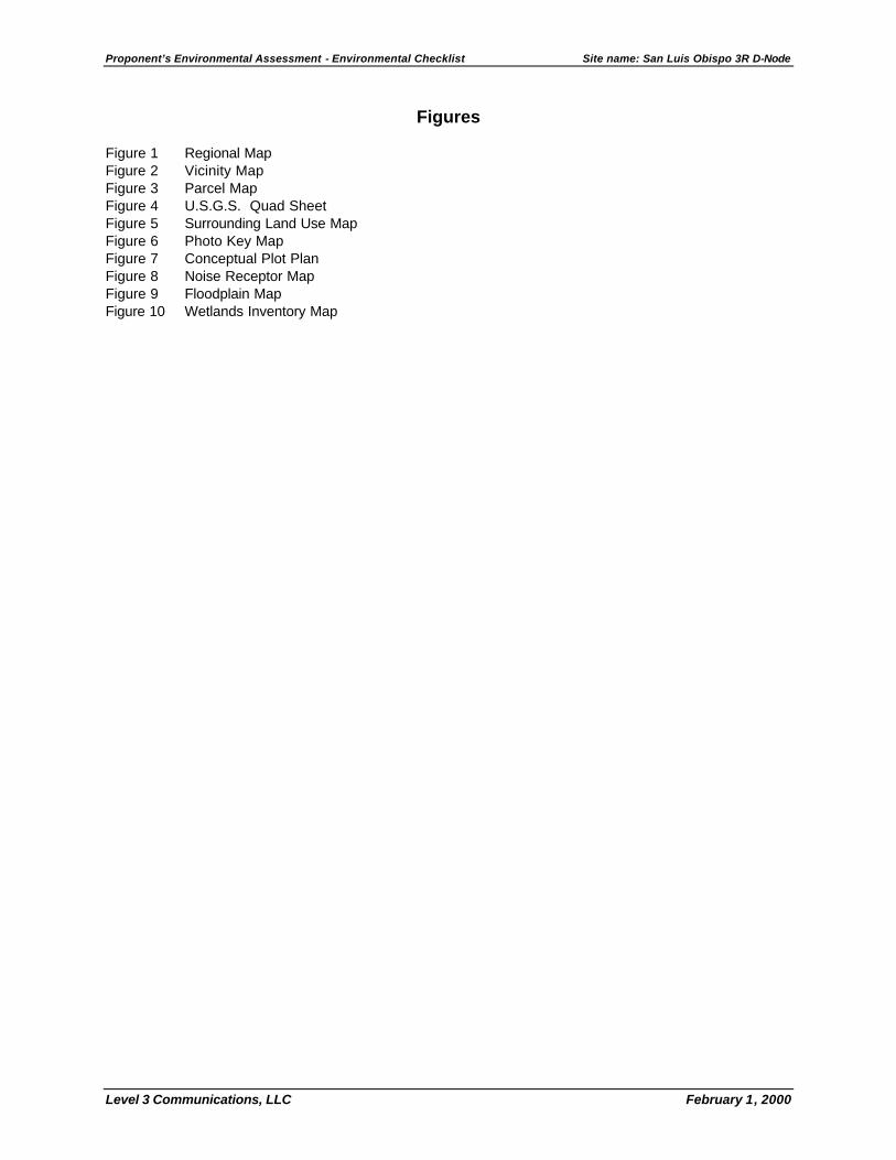
Proponent’s Environmental Assessment - Environmental Checklist Site name: San Luis Obispo 3R D-Node
Level 3 Communications, LLC February 1, 2000
Figures Figure 1 Regional Map Figure 2 Vicinity Map Figure 3 Parcel Map Figure 4 U.S.G.S. Quad Sheet Figure 5 Surrounding Land Use Map Figure 6 Photo Key Map Figure 7 Conceptual Plot Plan Figure 8 Noise Receptor Map Figure 9 Floodplain Map Figure 10 Wetlands Inventory Map

Proponent’s Environmental Assessment - Environmental Checklist Site name: San Luis Obispo 3R D-Node
Level 3 Communications, LLC February 1, 2000
Photo Plates Photo A View of West Face of Building Photo B View of East Face of Building Photo C Proposed Entrance Location of Capitolio Way Photo D View of Site from Broad Street (SR-227) Photo E North Face of Building, Proposed New Entrance Location
Proponent’s Environmental Assessment - Environmental Checklist Site name: San Luis Obispo 3R D-Node
Level 3 Communications, LLC February 1, 2000
Attachments Attachment A Methodologies, Algorithms, and Assumptions Used in the Air and Noise Analysis.