Site B-Meromictic Lake Site Analysis
92
SITE ANALYSIS SITE ANALYSIS SITE B PANTAI KERACHUT PENANG MALAYSIA - DESIGN STUDIO 2 -
-
Upload
fam-kian -
Category
Technology
-
view
487 -
download
1
Transcript of Site B-Meromictic Lake Site Analysis

SIT
E A
NA
LY
SIS
SITE ANALYSIS
SITE B
PANTAI KERACHUT
PENANG
MALAYSIA
- DESIGN STUDIO 2 -
SIT
E P
LA
N
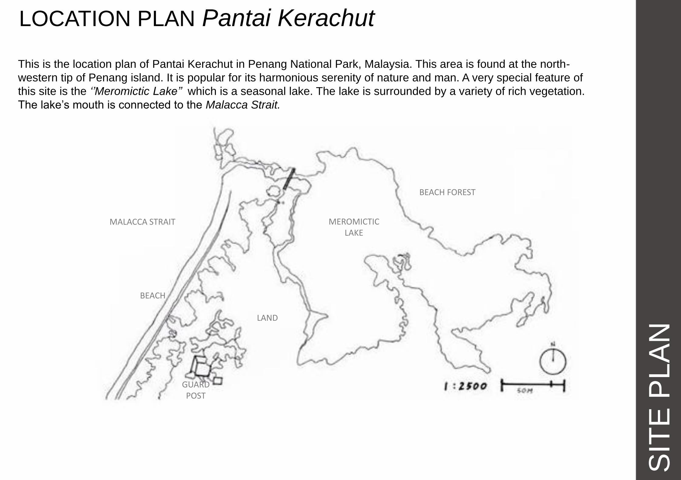
LOCATION PLAN Pantai Kerachut
This is the location plan of Pantai Kerachut in Penang National Park, Malaysia. This area is found at the north-
western tip of Penang island. It is popular for its harmonious serenity of nature and man. A very special feature of
this site is the ‘’Meromictic Lake’’ which is a seasonal lake. The lake is surrounded by a variety of rich vegetation.
The lake’s mouth is connected to the Malacca Strait.
MALACCA STRAIT MEROMICTIC LAKE
BEACH FOREST
LAND
BEACH
GUARDPOST

SIT
E P
LA
N
SITE PLAN
This area denotes our intended site area of 100m x 200m, ensuring the bridge entrance is included as well as the
mouth of the lake, where a special phenomenon takes place. That of allowing sea water into the lake but
preventing it from backwashing into the sea, creating two layers of water ; fresh water and sea water in the lake,
hence the name, Meromictic Lake. Our site also allows generous amount of flat gentle land.
MALACCA STRAIT MEROMICTIC
LAKE
BRIDGE
BEACH FOREST
LAND
MEROMICTIC LAKE
BEACH 200m
100m

The map here shows the contours of the area. The lowest contour height is -2m. And the highest is 34m. The
0m contour line represents the sea level. It is clear that this area is made of both steep terrain as well as some
areas of gentle flat land.
SIT
E P
LA
N
CONTOURS
MALACCA STRAIT MEROMICTIC
LAKE
BRIDGE BEACH FOREST
LAND
MEROMICTIC LAKE
BEACH

SIT
E P
LA
N
SECTIONS
Due to the complex terrain surrounding our site, we realised it would be ideal for us to have general sections of the
area instead of simply limiting it to within our site, to indicate the gradient of the slopes as well as their heights above
sea level.
MALACCA STRAIT MEROMICTIC
LAKE
BRIDGE
BEACH FOREST
LAND
MEROMICTIC LAKE
BEACH

SIT
E P
LA
N
SECTION A-1
The sections are to indicate the shape of the terrain. Each
base line of the section represents its ‘’ground’’ where we
walk on. The top line represents the back drop of the
mountain in our area.
Legend:
Section A-1
GROUND SURFACE
MOUNTAIN TOP
SEA LEVEL
MALACCA STRAIT
MEROMICTIC LAKE
BRIDGE
BEACH FOREST
LAND
MEROMICTIC LAKE
BEACH
BEACH FOREST

SIT
E P
LA
N
SECTION A-2
The sections are to indicate the shape of the terrain. Each
base line of the section represents its ‘’ground’’ where we
walk on. The top line represents the back drop of the
mountain in our area.
Legend:
Section A-1
Section A-2
GROUND SURFACE
MOUNTAIN TOP
SEA LEVEL
MALACCA STRAIT
MEROMICTIC LAKE
BRIDGE
BEACH FOREST
LAND
MEROMICTIC LAKE
BEACH
BEACH FOREST

SIT
E P
LA
N
SECTION A-3
The sections are to indicate the shape of the terrain. Each
base line of the section represents its ‘’ground’’ where we
walk on. The top line represents the back drop of the
mountain in our area.
Legend:
Section A-1
Section A-2
Section A-3
GROUND SURFACE
MOUNTAIN TOP
SEA LEVEL
MALACCA STRAIT
MEROMICTIC LAKE
BRIDGE
BEACH FOREST
LAND
MEROMICTIC LAKE
BEACH
BEACH FOREST

SIT
E P
LA
N
SECTION A-4
The sections are to indicate the shape of the terrain. Each
base line of the section represents its ‘’ground’’ where we
walk on. The top line represents the back drop of the
mountain in our area.
Legend:
Section A-1
Section A-2
Section A-3
Section A-4
GROUND SURFACE
MOUNTAIN TOP
SEA LEVEL
MALACCA STRAIT
MEROMICTIC LAKE
BRIDGE
BEACH FOREST
LAND
MEROMICTIC LAKE
BEACH
BEACH FOREST

SIT
E P
LA
N
SECTION A-5
The sections are to indicate the shape of the terrain. Each
base line of the section represents its ‘’ground’’ where we
walk on. The top line represents the back drop of the
mountain in our area.
Legend:
Section A-1
Section A-2
Section A-3
Section A-4
Section A-5
GROUND SURFACE
MOUNTAIN TOP
SEA LEVEL
MALACCA STRAIT
MEROMICTIC LAKE
BRIDGE
BEACH FOREST
LAND
MEROMICTIC LAKE
BEACH
BEACH FOREST

SIT
E P
LA
N
SECTION B-1
The longitudinal sections also indicates the shape of the terrain. Each base line of the section
represents its ‘’ground’’ where we walk on. The top line represents the back drop of the mountain in
our area.
Legend:
Section B-1
GROUND SURFACE
MOUNTAIN TOP
SEA LEVEL
MALACCA STRAIT
MEROMICTIC LAKE
BRIDGE BEACH FOREST
LAND
MEROMICTIC LAKE
BEACH

SIT
E P
LA
N
SECTION B-2
The longitudinal sections also indicate the shape of the terrain. Each base line of the section
represents its ‘’ground’’ where we walk on. The top line represents the back drop of the mountain in
our area.
Legend:
Section B-1
Section B-2
GROUND SURFACE
MOUNTAIN TOP
SEA LEVEL
MALACCA STRAIT
MEROMICTIC LAKE
BRIDGE BEACH FOREST
LAND
MEROMICTIC LAKE
BEACH

SIT
E P
LA
N
SECTION B-3
The longitudinal sections are to indicate the shape of the terrain. Each base line of the section
represents its ‘’ground’’ where we walk on. The top line represents the back drop of the mountain in
our area.
Legend:
Section B-1
Section B-2
Section B-3
GROUND SURFACE
MOUNTAIN TOP
SEA LEVEL
MALACCA STRAIT
MEROMICTIC LAKE
BRIDGE BEACH FOREST
LAND
MEROMICTIC LAKE
BEACH

CIR
CU
LA
TIO
N
MACRO
Legend :
A i r p l a n e R o u t e
C a r a n d B u s R o u t e
T r a i n R o u t e
Selangor
Penang
Penang Island
Georgetown
Teluk Bahang
Pahang
Negeri Sembilan
Malacca Johor
Terengganu
Kelantan Perak
Kedah
Peninsular Malaysia
Perlis
Batu Feringgi
Bayan Lepas
Pulau
Jerejak
Botanical
Garden

CIR
CU
LA
TIO
N
MICRO Pedestrian Path (Site: Lake) Hiking and Boat-Riding Path (Site: Teluk Bahang--
- Pantai Kerachut )
Legend:
P e d e s t r i a n P a t h
V e h i c l e P a t h
Legend:
M a j o r P e d e s t r i a n P a t h
M i n o r P e d e s t r i a n P a t h
Our Site
Pavilion
River
Camping Site
Hall
Jetty
Bridge
Beach Forest
Beach Forest
Beach Forest
Meromictic
Lake
Sea
Beach Entrance
CIR
CU
LA
TIO
N
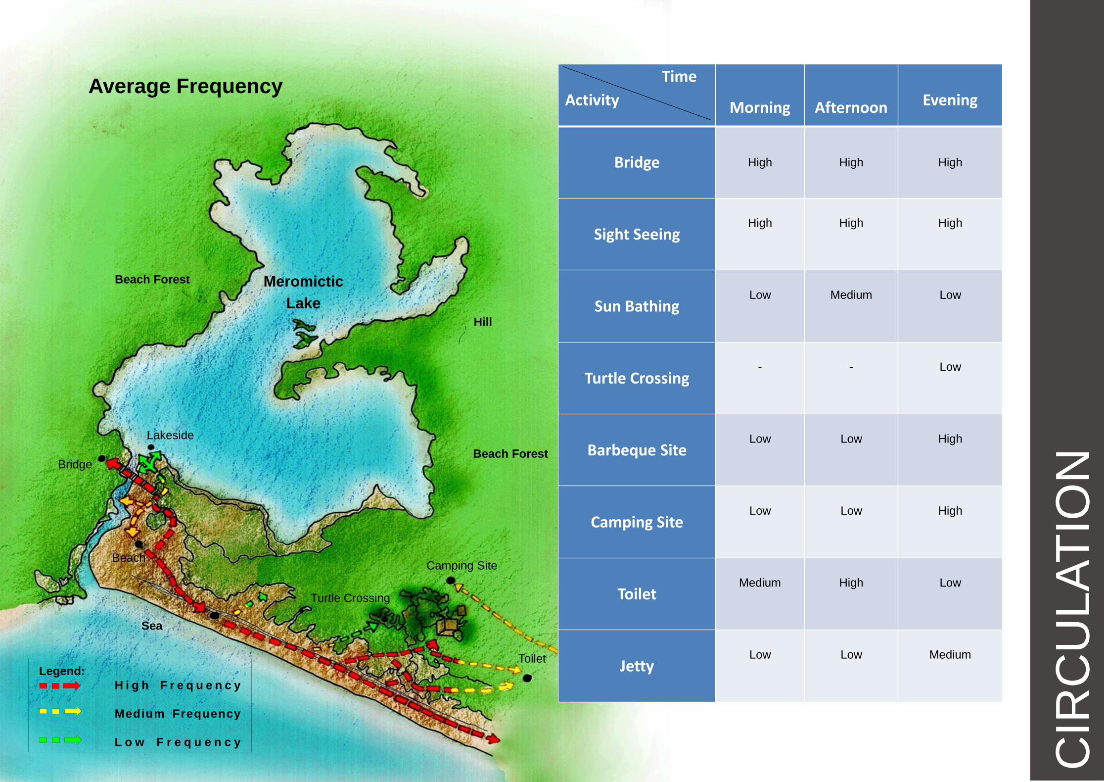
Frequency
Average Frequency
Legend:
H i g h F r e q u e n c y
Medium Frequency
L o w F r e q u e n c y
Lakeside
Bridge
Beach Camping Site
Toilet
Sea
Beach Forest
Hill
Meromictic
Lake
Beach Forest
Time
Activity
Morning
Afternoon
Evening
Bridge
High High High
Sight Seeing
High
High
High
Sun Bathing
Low
Medium
Low
Turtle Crossing
-
-
Low
Barbeque Site
Low
Low
High
Camping Site
Low
Low
High
Toilet
Medium
High
Low
Jetty
Low
Low
Medium
Turtle Crossing

CL
IMA
TE
SUN

CLIM
AT
E
WIND When the wind pressure flows through the enclosed area of
the trees and vegetations, being smaller in diameter, the
restriction causes a higher pressure at the narrow end. This
difference in pressure causes the wind flow to accelerate
towards the low pressure narrow section, creating a higher
constant speed.
Land Breeze and Sea Breeze

CL
IMA
TE
TEMPERATURE & HUMIDITY
Month Jan Feb Mar Apr May Jun Jul Aug Sep Oct Nov Dec
Max. Temperature (Celcius)
31.7 32.3 32.1 32 32.1 31.8 31.8 31.3 31.1 30.8 31 31
Min. Temperature (Celcius)
24.6 24.8 24.9 25.2 25.1 25.2 25.2 24.8 24.4 24.5 24.4 24.5
Intermonsoon
season
Intermonsoon
season
• Formation of lake occur during intermonsoon seasons, which
Sumatra winds bring in strong waves and heavy rainfalls.
• Throughout April-May and Oct-Nov, the lake will form and dry
up in 1 hour 15mins for several times.
Northeast monsoon
(May – Sept)
Southwest monsoon
(Nov – March)
• The lake has low water levels during
the dry season which is filled mostly
with fresh water from the streams and
the water levels follows the sea tide
levels throughout the day.
CLIM
AT
E
8 8
15 16
14
11 12
14
17
21
19
15
0
5
10
15
20
25
Jan Feb Mar Apr May Jun Jul Aug Sep Oct Nov Dec
Yearly precipitation (days)
LAKE CYCLE
Low tide (0 ~10cm) Natural dam formed

CL
IMA
TE
LAKE CYCLE High tide (20~50cm) Maximum water level (~170cm excluding mud level)
Lake with maximum water level

LEGEND: location spot
route to Virginia Forest
Entrance to Virginia Forest
Hall
Camping site
Pavilion
Bridge
River
Meromictic Lake
The Meromictic Lake in Penang National Park is
a lake that can adapt to two types of water:
where it mainly receive water from five different
streams and the sea.
Due to the presence of different densities in
these two water, the lake is seperated into two
layers, where the sea water exist in the lower
layer while other stream water lays in the upper
layer.
Besides, the lake also consist of two different
temperature.The stream water on the lower
part has a higher temperature if compared to the
sea water which is cooler.
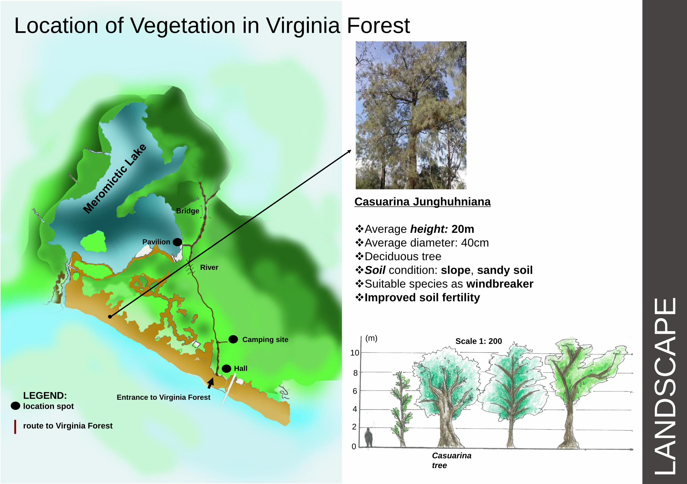
Location of Vegetation in Virginia Forest
LA
ND
SC
AP
E

LA
ND
SC
AP
E
Landscape, Elevation & Sections Vegetations & Aquatic Livings
Casuarina Tree
Weed
East -South Elevation (Scale
1:350)
A
A
B B
Site Plan (N.T.S.) North-East Cross Section A-A (Scale 1:350)
Fiddler crabs
Shed shells as they grow.
Lost legs or claws during their present growth cycle, a
new one will be present when they molt
Smallest size about diameter of a 50 cent coin

LA
ND
SC
AP
E
Landscape, Elevation & Sections Vegetations & Aquatic Livings
Casuarina Tree
Weed
East -South Elevation (Scale
1:350)
A
A
B B
Site Plan (N.T.S.) North-East Cross Section A-A (Scale 1:350)
Faunus Ater
Brackish water snail species with an operculum
Aperture is ovate and white
The shell has two deep sinuses: an anal sinus
which is close to the suture and an anterior sinus more
forward in the aperture
Operculum is oval, corneous and dark brown

LA
ND
SC
AP
E
East-South Longitudinal Section B-B (Scale 1:350) Dry season (November~March)
South-West Monsoon season (April~October)
Sea water cannot enter the lake while high tide
Water from the streams evaporates within 1.5 hrs
Water level will reach maximum height (1.7m)
when high tide
East-South Longitudinal Section B-B (Scale
1:350)
Water level of The Lake
Landscape, Elevation & Sections

LA
ND
SC
AP
E
East-South Longitudinal Section B-B (Scale
1:350)
Dry season (November~March)
South-West Monsoon season (April~October)
Red Mangrove
Prop roots ("breathing tubes")
heights of up to 30 cm
Prop themselves above the
water level to absorb air through
pores in their bark .
Wind barrier
East-South Longitudinal Section B-B (Scale
1:350)
Landscape, Elevation & Sections Location of Vegetation of The Lake

LA
ND
SC
AP
E
LEGEND: location spot
route to Virginia Forest
Entrance to Virginia Forest
Hall
Camping site
Pavilion
Bridge
River
Location of Vegetation in Virginia Forest
Tongkat Ali
Height: (7-8) m
Scientific name: Eurycomal Longifolia
Another common name: Pasak bumi
Family of Simaroubaceae
Evergreen tree
Function as herb: Pro-fertility and aphrodisiac
Tongkat
Ali
0
2
4
6
8
10
(m) Scale 1: 200

LA
ND
SC
AP
E
LEGEND: location spot
route to Virginia Forest
Entrance to Virginia Forest
Hall
Camping site
Pavilion
Bridge
River
Kacip Fatimah
Scientific name: Labisia Pumila Benth
Common name: Selusuh Fatimah
Leaf size: 0.2m
Herbaceous shrub with creeping rhizomes
Surrounding: High humidity and shady
Function as herb: afterbirth care
Kacip
Fatimah
Location of Vegetation in Virginia Forest
0
20
40
60
80
(cm) Scale 1: 20

LA
ND
SC
AP
E
LEGEND: location spot
route to Virginia Forest
Entrance to Virginia Forest
Hall
Camping site
Pavilion
Bridge
River
Kelentit Kering
Yellow-footed polypore
Microporus Xanthopus species
Polyporaceae family
Diameter: 0.09m
Grow on rotting wood
Kelentik
Kering
Location of Vegetation in Virginia Forest
0
20
40
60
80
(cm) Scale 1: 20

LA
ND
SC
AP
E
LEGEND: location spot
route to Virginia Forest
Entrance to Virginia Forest
Hall
Camping site
Pavilion
Bridge
River
Nepenthes Ampullaria
(Ground species Pitcher plant)
Height: 0.1m
Width: 0.07m
Carnivorous plant, feed on insects
Able to grow in poor soils
Oten grow in damp, shady and humid area
Separate to two types
Pitcher
Plant
Location of Vegetation in Virginia Forest
0
20
40
60
80
(cm) Scale 1: 20

LA
ND
SC
AP
E
LEGEND: location spot
route to Virginia Forest
Entrance to Virginia Forest
Hall
Camping site
Pavilion
Bridge
River
Location of Vegetation in Virginia Forest
Bintangor
Height: 10m
Diameter: 0.125m
Long waxy leaves
Soil condition: swampy area
Poisonous latex: used for stunning fish
Function as herb: Ease headache and rashes
Bintangor
0
2
4
6
8
10
(m) Scale 1: 200

LA
ND
SC
AP
E
LEGEND: location spot
route to Virginia Forest
Entrance to Virginia Forest
Hall
Camping site
Pavilion
Bridge
River
Location of Vegetation in Virginia Forest
Bintangor
Height: 10m
Diameter: 0.125m
Long waxy leaves
Soil condition: swampy area
Poisonous latex: used for stunning fish
Function as herb: Ease headache and rashes
Bintangor
0
2
4
6
8
10
(m) Scale 1: 200
LA
ND
SC
AP
E
LEGEND: location spot
route to Virginia Forest
Entrance to Virginia Forest
Hall
Camping site
Pavilion
Bridge
River
Location of Vegetation in Virginia Forest
Casuarina Junghuhniana
Average height: 20m
Average diameter: 40cm
Deciduous tree
Soil condition: slope, sandy soil
Suitable species as windbreaker
Improved soil fertility
Casuarina
tree
0
2
4
6
8
10
(m) Scale 1: 200

LA
ND
SC
AP
E
LEGEND: location spot
route to Virginia Forest
Entrance to Virginia Forest
Hall
Camping site
Pavilion
Bridge
River
Location of Birds foraging in Virginia Forest Humming Bird
Smallest of birds (7.5 – 13) cm
Humming sound created by their
beating wings.
Pigeon
12 inches.
Feed on seeds, fruits, and
plants.
0.5 – 2 kg .
Magpie
Lifespan: 25 y
0.2 – 0.4 kg (Adult)
Length: 37 – 43 cm (Adult), 44 –
46 cm (Adult)
Bulbul
Short-necked
Length from 13cm to 29cm .
Highly vocal, with the calls of
most species being described as
nasal or gravelly.
(5.00 a.m. morning)

AC
TIV
ITIE
S
LEGAL ACTIVITES BARBECUE & PICNIC AREA
- Barbecuing normally happens in the afternoon and evening. - Food is not provided by the park. - Besides barbecuing, camping is available with the limitation of 100
visitors at the campsite. No charges are applied for camping. - Cooking and camping facilities are not provided. - These activities are mostly preferred by locals, especially during public
holidays and school holidays.

AC
TIV
ITIE
S
LEGAL ACTIVITES SIGHT SEEING BY THE LAKE
SIGHT SEEING IN THE BEACH FOREST
SIGHT SEEING AT THE BEACH
- The best time for sightseeing at these sites is from morning to noon. - It is not advised to visit the lake and the beach during the night
because of the high tide from the sea. - During November to March, the lake becomes dry and muddy due to
the dry season so it is not ideal to visit during that time.

AC
TIV
ITIE
S
LEGAL ACTIVITES
TURTLE NESTING
Nesting - Green Turtles nesting: April to August - Olive Ridley Turtle nesting: September
to February - Nesting occurs at night. - Viewing is allowed but with minimal
light shining at the turtles as to not disrupt the process.
Nesting Site Selection - Located under the vegetative cover of
merambong trees - Open sands - Under bushes
Based on the statistics of 2008 & 2009, 60% of Green Turtle nests were located under merambong trees, 24.8% were located under bushes and 14.9% in open sands.

AC
TIV
ITIE
S
LEGAL ACTIVITES
TURTLE CONSERVATION SANCTUARY
Turtle Hatchery & Sanctuary - The cage indicates that the eggs are
being incubated until they are ready to be hatched.
- Office hours: 7.30AM – 6PM
- After the eggs are laid, they are reburied in the hatchery nests excavated to a depth of 60cm deep & 25cm wide.
- After placing them in the nesting chamber, the nest is compacted with remaining sand and left for incubation.
- They then label the clutches using bamboo sticks & cover the nest with a protective netting to avoid predation attempts.

AC
TIV
ITIE
S
LEGAL ACTIVITES
- There are 3 hiking trails in Penang National Park. - The best months to hike is throughout the year, excluding the
months of March - April because they are the ludicrously hot months therefore it is not ideal to hike.
- The distance from Teluk Bahang to Pantai Kerachut is 3km and the hike usually takes around 1.5 -2 hours, depending on individual speed.
JUNGLE TREKKING / HIKING

AC
TIV
ITIE
S
LEGAL ACTIVITES
JETTY / FISHING
The lake is a dry mud bank during neap tides and dry season. October to April is not a good time to visit
the lake.
- Pre booking is required for 15-20 minutes boat ride from Pantai Kerachut back to Teluk Bahang abd vise versa.

AC
TIV
ITIE
S
LEGAL ACTIVITES
SHELTER
Shelter is provided for visitors to rest and bird watching. It’s a place for people to gather around.
Bird watching is available at 5am and in the evening. This activity happens often due to the migration of different species of birds.
BIRD WATCHING

AC
TIV
ITIE
S
ILLEGAL ACTIVITES SWIMMING
HERBS COLLECTING
Swimming is not allowed as a precaution for jellyfish stings.
Herbs collecting is not allowed as a measure of preservation of nature.
SMOKING
Smoking is prohibited throughout the park to sustain the air quality and cleanliness.

EX
IST
ING
ST
RU
CT
UR
E
LOCATION OF EXISTING STRUCTURES
(site plan)

EX
IST
ING
ST
RU
CT
UR
E
LOCATION OF EXISTING STRUCTURES
(site plan)

EX
IST
ING
ST
RU
CT
UR
E
LOCATION OF EXISTING STRUCTURES
(site plan)

EX
IST
ING
ST
RU
CT
UR
E
LOCATION OF EXISTING STRUCTURES
(location plan)

EX
IST
ING
ST
RU
CT
UR
E
LOCATION OF EXISTING STRUCTURES
(location plan)

EX
IST
ING
ST
RU
CT
UR
E
LOCATION OF EXISTING STRUCTURES
(location plan)

EX
IST
ING
ST
RU
CT
UR
E
MEASUREMENTS Suspension Bridge
PLAN SCALE 1:100
SIDE ELEVATION SCALE 1:100
FRONT ELEVATION SCALE 1:100
EX
IST
ING
ST
RU
CT
UR
E
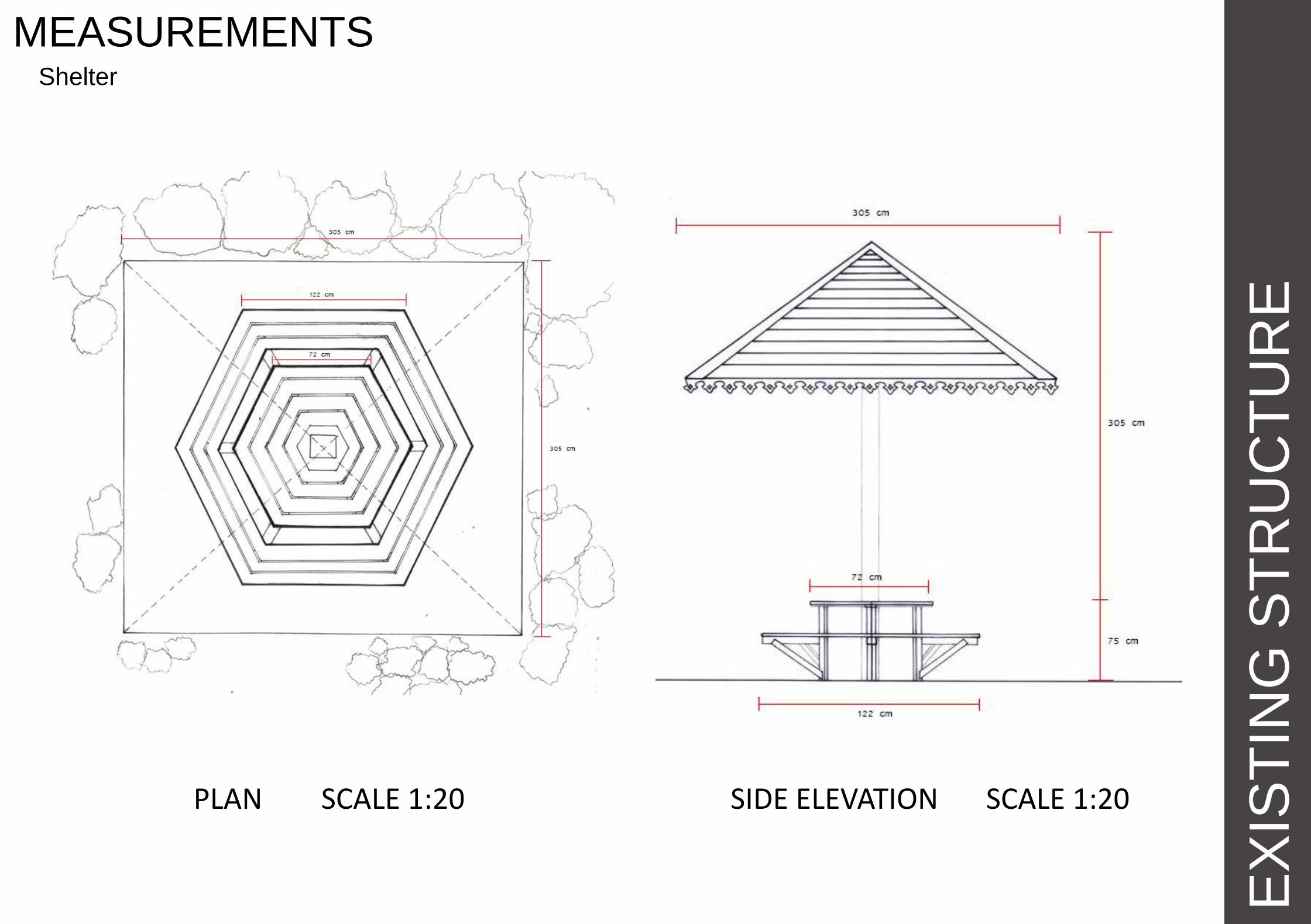
MEASUREMENTS Shelter
PLAN SCALE 1:20 SIDE ELEVATION SCALE 1:20

EX
IST
ING
ST
RU
CT
UR
E
PURPOSE OF EXISTENCE Suspension Bridge
• To connect forest and Pantai Kerachut
• To provide an extensive view of Tasik Meromiktik
• To act as a clear border between the sea and the lake

EX
IST
ING
ST
RU
CR
UR
E
REASON OF CHOICE
• Difference in height between the
two lands.
• Less hassle during construction.
Suspension Bridge

EX
IST
ING
ST
RU
CT
UR
E
MATERIALS USED Suspension Bridge
Platform
Fibre Cement Board
Handle
Polyvinyl Chloride
Base
Concrete
Columns
Concrete Supporting Cables
Steel Cable
Supporting I – beams
Galvanized Mild Steel

EX
IST
ING
ST
RU
CT
UR
E
REASON OF CHOICE Suspension Bridge

EX
IST
ING
ST
RU
CT
UR
E
PURPOSE OF EXISTENCE Shelter
• Acts as a shelter during sunny or rainy days
• To allow mountain hikers and beach lovers to have a nice place to rest
• To bring the Malay traditional flavours to Pantai Kerachut

EX
IST
ING
ST
RU
CT
UR
E
MATERIALS USED Shelter
Kapur Wood – Shellac coated

EX
IST
ING
ST
RU
CT
UR
E
PURPOSE OF EXISTENCE Guard Post
• To provide security
• To ensure cleanliness
• To carry out registration

EX
IST
ING
ST
RU
CT
UR
E
MATERIALS USED Guard Post
Kapur Wood – Shellac coated

EX
IST
ING
ST
RU
CT
UR
E
PURPOSE OF EXISTENCE Sign Boards

VIE
WS
AN
D S
EN
SO
RY
SITE ANALYSIS

VIE
WS
AN
D S
EN
SO
RY
WIND

VIE
WS
AN
D S
EN
SO
RY
NOISE
Sound of sea breeze and sea waves
Sound of waves splashing onto the rocks
Sound of the nature and insects from the forest
Sound of the wind and sea breeze
Sound of the insects and birds from the forest
Sound of the insects and birds from the forest

VIE
WS
AN
D S
EN
SO
RY
VIEWS FROM THE SITE

VIE
WS
AN
D S
EN
SO
RY
VIEWS
Point A Point B Point C

VIE
WS
AN
D S
EN
SO
RY
VIEW QUALITIES FROM SITE

VIE
WS
AN
D S
EN
SO
RY
POINT A (VIEWS FROM BRIDGE)

VIE
WS
AN
D S
EN
SO
RY
POINT B (VIEWS FROM LAKESIDE)

VIE
WS
AN
D S
EN
SO
RY
POINT C

VIE
WS
AN
D S
EN
SO
RY
VIEWS THROUGH THE SITE

VIE
WS
AN
D S
EN
SO
RY
VIEWS TO THE SITE

VIE
WS
AN
D S
EN
SO
RY
VIEWS TO THE SITE

VIE
WS
AN
D S
EN
SO
RY
BEST VIEWS

VIE
WS
AN
D S
EN
SO
RY
BEST VIEWS (EAST)
One of the best nature view during 6.45am-7.25am, when the sun rises.

BEST VIEWS (WEST)
VIE
WS
AN
D S
EN
SO
RY
One of the best nature view during 5.45pm-7.15pm, when the sun rises.

Site Plan ( 1:1500 )

Forest Ranger A forest ranger is a person entrusted with protecting and
preserving forests
DUTY
- To protect the park resources for future generations
- To protect park visitors.
SKILLS
- Have strong communication and leadership skills
- Physically fit
- Have knowledge of basic first aid, surviving skills
EQUIPMENTS
- First Aid kit to rescue visitors if any emergency
happened.
- Fire-fighting tools to prevent forest fire if there is any.
- Torch light, matches or lighters
- Knife
- Safety Boot
- Water Bottle
- Rope
- Other appropriate gears
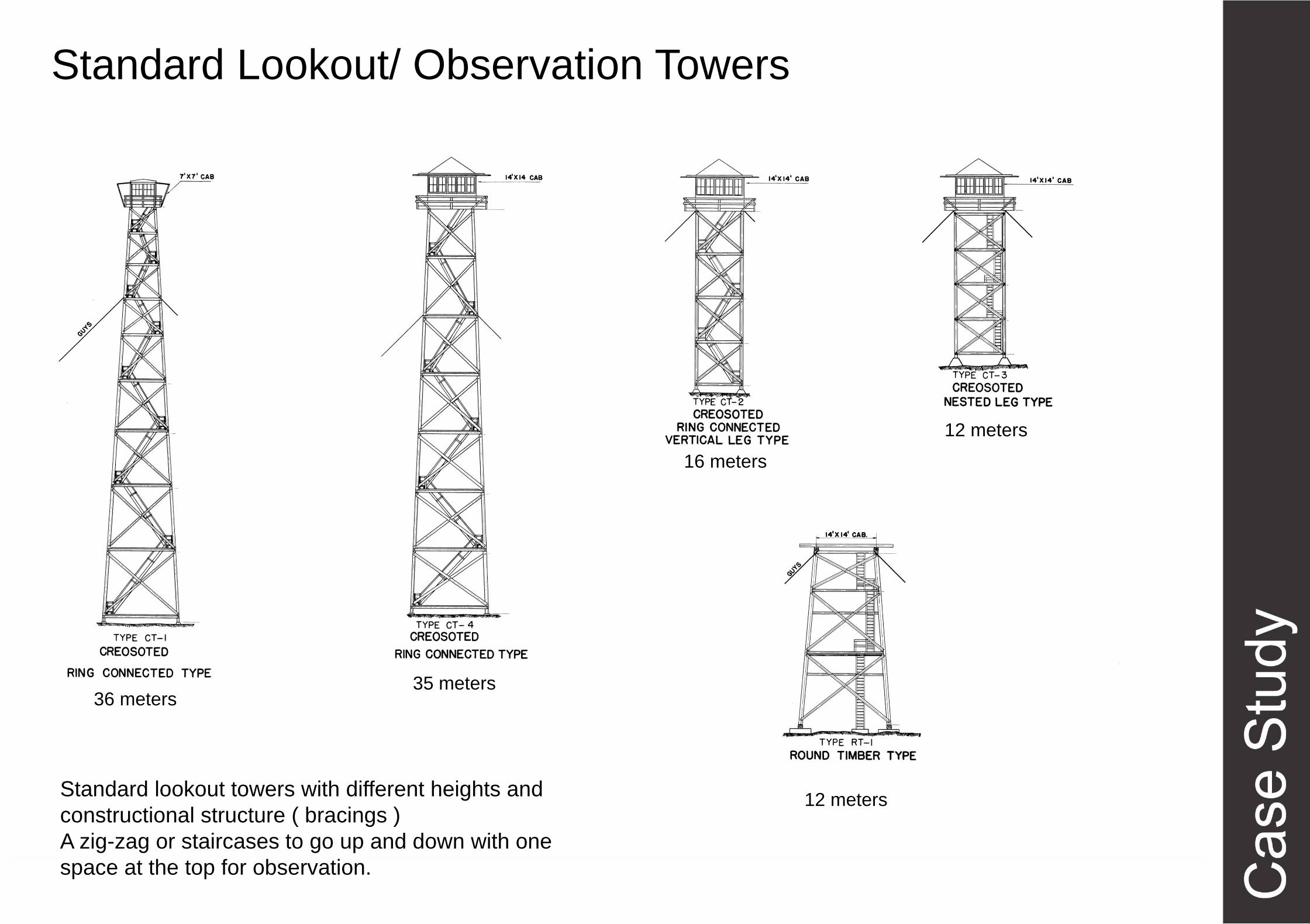
36 meters 35 meters
16 meters
12 meters
12 meters
Standard Lookout/ Observation Towers
Standard lookout towers with different heights and
constructional structure ( bracings )
A zig-zag or staircases to go up and down with one
space at the top for observation.

Simple Local Guard Towers
- Located in Teluk Cempedak Beach, Kuantan
- Constructed with concrete and consists of wooden or
steel handrails for stairs
- Simplest structure with one staircase around the
tower to go up and down
- Located between Hyatt Hotel and Commercial street
nearby Mc Donald Restaurant
- Provide good overall view of the sea for safety
purpose

Korkeasaari Lookout Tower
Ville Hara
Helsinki, Finland
-Situated on a site 18 meters above sea
- Competition for design of Ten meters high
Timber Tower
- Provide spectacular views of the sea and city
of Helsinki
- Landmark of Korkeasaari Island

- The load bearing structure consists of 72 long
battens, with a section of 60mmx60mm, that are
bent and twisted on the site from seven pre-bent
types.
- Over 600 bolted joints hold the shell structure
together.
- The wood is treated with a linen oil-based
wood balm with UV-protection.


- A batten is a thin strip of solid
material, typically made from wood,
plastic or metal.
- Battens are used in building
construction and various other fields.
- Ideal for external cladding and
facades
- Light and strong material

JeJawi Tower, Pulau Ubin, Singapore
- Located at Chek Jawa Wetlands,
- Big attraction for bird watching and view most of greenery in
Pulau Ubin
- 21 meters tall viewing tower
- Includes 7 storeys of 3-meter risers and at each storey, there is
a small deck for observing the surroundings

- There is one staircase to go up and come down.
- Can accommodate 20 people at the top cabin.
- Materials – Steel and Timber

Cross Bracing
K-Bracing Eccentric
Types of Bracing
- Construction includes diagonal bracing from the base to the top.
- Consists of Four primary post columns with bracings

Killesberg Tower
Stuttgart, Baden-Wurttemberg, Germany
- Observatory Tower completed in 2000, designed by
Jorg Schlaich
- Consists of 5 floors above the ground
- 40.3 meters high and base width is 21 meters
- Landmark of Stuggart

- The tower is accessed by two open-air spiral
staircases : One to go up and one to go down.
- 4 platforms and 2 counter-rotating stairs (348 steps)
- Height to observation deck from ground – 31 meters
- The tower has different heights in viewing platforms –
8 m, 16m, 24m, 31m.

- Main Material used is Steel.
- Constructed with steel mesh and pre-stressed cable
net type with an open lattice structure.
- There are 48 cables.

Bird Observation Tower
- Designed by GMP architects
- Located on the far-projecting peninsula
Graswarder, Heiligenhafen, Germany
- 12.5 meters high
- Gross External Area : 48 meter squared
- Wooden construction made of Siberian Larch
Heiligenhafen Germany
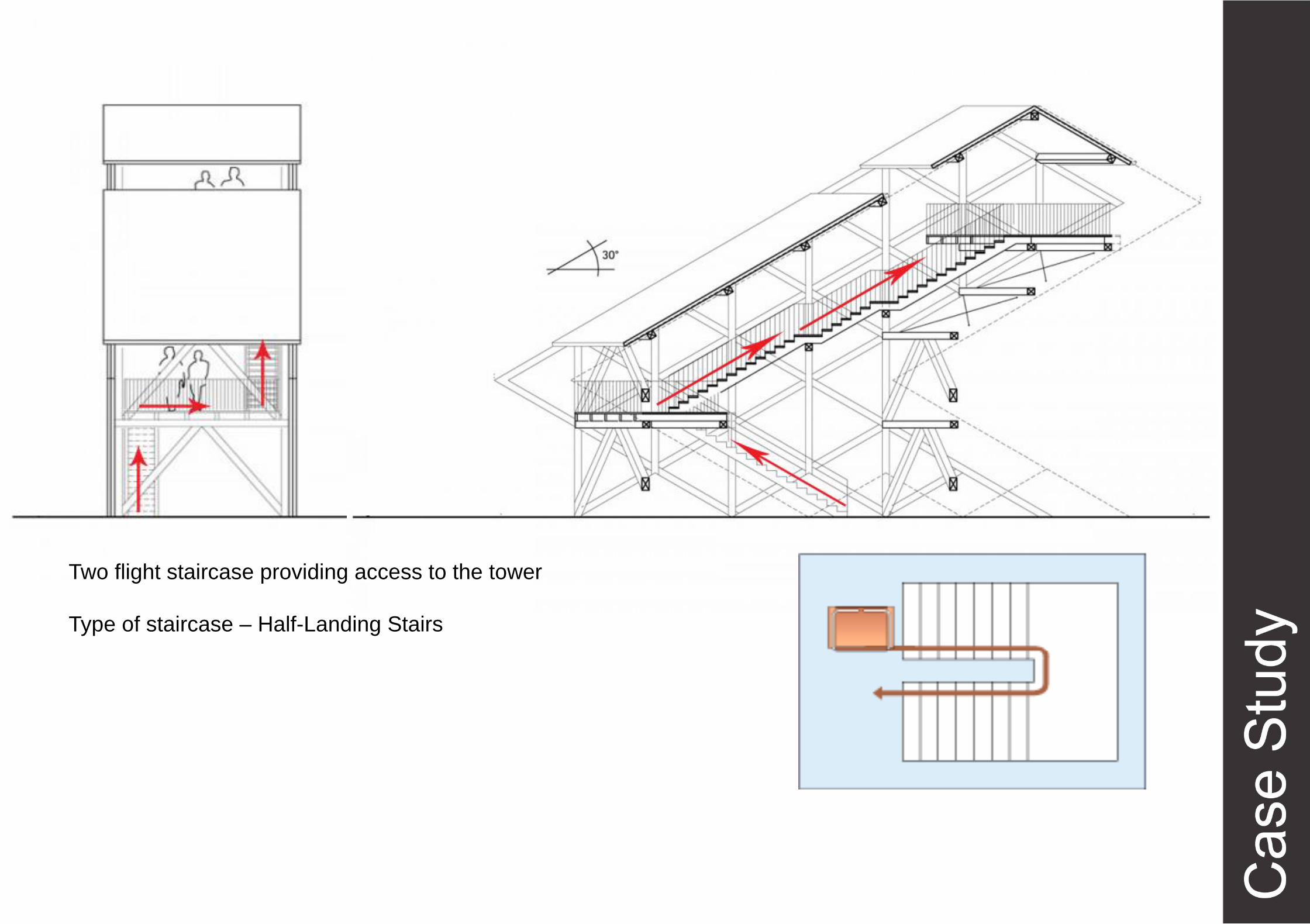
Two flight staircase providing access to the tower
Type of staircase – Half-Landing Stairs

Siberian Larch Wood is used for Decking and Siding.
With great stability, durability, and its natural resistance for
decay are the most impressive features.
A type of hard wood with high density and they are
aesthetically beautiful with natural color.

Inspirations
Vienna Jubilaeumswarte
Observation Tower on the River Mur,
Border of Austria and Slovneia
The Jübergtower, Germany
Tower at Honda Wetlands,Ohio
Observation Tower at
Putrajaya Water Sports Complex
Lookout tower at
Pipestem Resort,
West Virginia
Bird-watching Tower in Heitasaari Island,
Finland