1 Colonial Empires About 1900. 2 The early 20 th century: Full-blown MODERNIS M.

1
ISSN 1712-8056[Print]ISSN 1923-6697[Online]
www.cscanada.netwww.cscanada.org
Canadian Social ScienceVol. 12, No. 11, 2016, pp. 1-32DOI:10.3968/8928
Copyright © Canadian Academy of Oriental and Occidental Culture
Since Colonial Empires in America to the Current Border Problems
Jean Pierre Bergoeing[a],*
[a]Ph.D., Professor, Geography Department, University of Costa Rica, San Jose, Costa Rica.*Corresponding author.
Received 22 August 2016; accepted 10 October 2016 Published online 26 November 2016
AbstractThe author makes a count of boundary problems in America, starting with those occurred in the 19th century after the independence of the English and Spanish colonies, to the present day. Through royalist attempts and wars of annexation. Also it’s included in this count Antarctica as an extension of the American continent initially disputed by Argentina, Chile and the United Kingdom and after of general interest to many other powers.Key words: International borders; Maritime coasts equidistance line; Latitudinal border; Historical borders reference (Uti possidetis de jure)
Bergoeing, J. P. (2016). Since Colonial Empires in America to the Current Border Problems. Canadian Social Science, 12(11), 1-32. Available from: http://www.cscanada.net/index.php/css/article/view/8928 DOI: http://dx.doi.org/10.3968/8928
INTRODUCCIONThe American continent known since ancient times for the many journeys made by the Phoenicians who discover the coast of the Brazil along the West coast of Africa being diverted by storms. Witness to this are the inscriptions carved in the Gavea stone in Barra da Tijuca, Rio de Janeiro, deciphered by Bernardo de Azevedo da Silva Ramos in 1932 (Silva, 1932) that can be dated 847 BC as well as inscriptions on high in the stone of Paraíba, in Pouso, discovered in 1872. The American epigraphist Cyrus Gordon showed in 1960, that the transcript was
authentic, because grammar concepts of the Phoenician language were completely unknown in 1872.
On the other hand, the arrival of the Vikings in the 8th century, in Canada, coming from Scandinavia through Greenland is another testimony, this time from the European presence in America. In 1960 in the Anse aux Meadows, in Newfoundland, Canada, was discovered a Viking settlement testimony of the early Norse presence in this part of America, the site was declared a world heritage site by UNESCO.
Even farther is the human presence with Monteverde culture, in Southern Chile dated at 35,000 years and which may correspond to trans-pacific trips, when the sea level was 394ft below the current level due to the last Ice Age (Wurm).
However, the official discovery of America and its subsequent colonization only begin with the arrival of the Sea Admiral, Christopher Columbus. On October 12, 1492 reached the Guanahani Island, Bahamas, and officially took possession of the new territory on behalf of the Crown of Castile. From that moment will begin the conquest and subsequent colonization of the American continent, by the two major maritime powers of that time; Spain and Portugal.
During the 19-century and half of the 20 century the territorial disputes between countries are solved through wars. With the creation of the United Nations in 1946 was also created the International Court of Justice, the judicial organ of the United Nations, whose headquarters are in The Hague, Netherlands. The Court official languages are English and French languages. Its functions are to resolve border disputes between countries by peaceful and legal means. Their sentences are final. The regulation of the 17 of April of 2005 sets the way of exercise its functions and its procedure rules. From its creation, many disputes have been subject to its jurisdiction with very positive results accepted by the parties in litigation.
Copyright © Canadian Academy of Oriental and Occidental Culture
Since Colonial Empires in America to the Current Border Problems
2
Figure 1Christopher Columbus Arrival in GuanahaniSource: Library of Congress, USA.
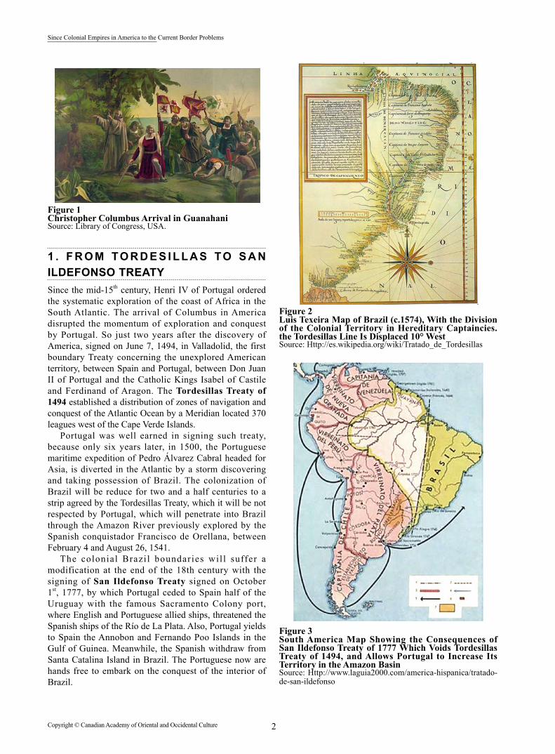
1 . F R O M TO R D E S I L L A S TO S A N ILDEFONSO TREATYSince the mid-15th century, Henri IV of Portugal ordered the systematic exploration of the coast of Africa in the South Atlantic. The arrival of Columbus in America disrupted the momentum of exploration and conquest by Portugal. So just two years after the discovery of America, signed on June 7, 1494, in Valladolid, the first boundary Treaty concerning the unexplored American territory, between Spain and Portugal, between Don Juan II of Portugal and the Catholic Kings Isabel of Castile and Ferdinand of Aragon. The Tordesillas Treaty of 1494 established a distribution of zones of navigation and conquest of the Atlantic Ocean by a Meridian located 370 leagues west of the Cape Verde Islands.
Portugal was well earned in signing such treaty, because only six years later, in 1500, the Portuguese maritime expedition of Pedro Álvarez Cabral headed for Asia, is diverted in the Atlantic by a storm discovering and taking possession of Brazil. The colonization of Brazil will be reduce for two and a half centuries to a strip agreed by the Tordesillas Treaty, which it will be not respected by Portugal, which will penetrate into Brazil through the Amazon River previously explored by the Spanish conquistador Francisco de Orellana, between February 4 and August 26, 1541.
The colonial Brazi l boundaries wil l suffer a modification at the end of the 18th century with the signing of San Ildefonso Treaty signed on October 1st, 1777, by which Portugal ceded to Spain half of the Uruguay with the famous Sacramento Colony port, where English and Portuguese allied ships, threatened the Spanish ships of the Río de La Plata. Also, Portugal yields to Spain the Annobon and Fernando Poo Islands in the Gulf of Guinea. Meanwhile, the Spanish withdraw from Santa Catalina Island in Brazil. The Portuguese now are hands free to embark on the conquest of the interior of Brazil.
Figure 2Luis Texeira Map of Brazil (c.1574), With the Division of the Colonial Territory in Hereditary Captaincies. the Tordesillas Line Is Displaced 10° WestSource: Http://es.wikipedia.org/wiki/Tratado_de_Tordesillas
Figure 3South America Map Showing the Consequences of San Ildefonso Treaty of 1777 Which Voids Tordesillas Treaty of 1494, and Allows Portugal to Increase Its Territory in the Amazon Basin Source: Http://www.laguia2000.com/america-hispanica/tratado-de-san-ildefonso

3 Copyright © Canadian Academy of Oriental and Occidental Culture
Jean Pierre Bergoeing (2016). Canadian Social Science, 12(11), 1-32
The Utrech Treaty of 1713 established a European political system of stability between the great powers of the time. By this treaty Portugal obtains of France to renounce its claims to the lands of the North Cape and the Oiapoque River which will be the new border between French Guiana and Brazil. In 1821, Brazil was peacefully separated from Portugal and proclaimed an independent empire. During the reign of don Pedro II, Brazil signed in 1851 a boundaries Treaty with Uruguay setting borders to as they are today. The border with Paraguay is defined after the war of the Triple Alliance (1864-1870) where Brazil seizes land previously colonized by Portuguese. During that same period Brazil signed the Ayacucho Treaty in 1867 by which Brazil incorporates into its territory the Acre state and part of the Amazon that belonged to Bolivia, which will trigger the war of Acre ending in favor of Brazil with the signing the Rio of Janeiro Treaty of 1909 through an exchange of lands with Peru.
The proclamation of the Republic in 1889 leads Brazil to redefine its international boundaries where José Maria da Silva Paranhos, Baron of Rio Blanco, will be a skillful negotiator, which attending the arbitration award of U.S. President Grover Cleveland (1893-1897), this will be awarded to Brazil; Parana and Santa Catarina claimed by Argentina and redefining the boundaries of the Peperiguacu and San Antonio Rivers.
Suriname and Brazil boundary was defined in 1906 by Baron of Rio Branco and the representative of the Netherlands Federico Palm. The limits with Colombia were sealed by the Waterway Fluvial Treaties of 1907 that defines the boundaries between the Negro River and the Aporis River and 1928 between the Apoporis River and the Amazon. With Peru borders were defined by the Rio de Janeiro Treaty of 1909, based on the principle of the “Uti Possidetis”. (Principle stating that the borders had at the beginning of independence is the valid). In 1904 the border with the British Guiana was defined in Great Britain where Brazil gained great advantage thanks to arbitration subject to the King of Italia Victor Emmanuel III.
Currently, Brazil is seeking to expand its maritime borders for fishery resources, oil and gas exploitation, from the Exclusive Economic Zone in the Atlantic Ocean. And still have to resolve a dispute with the “Rincón de Artigas” by Uruguay and the Brazilian island.
If the Tordesillas (1494) and San Ildefonso (1777) Treaties resolved the dispute between Spain and Portugal over the American possessions, was not so with the other European emerging powers such England, France and the Netherlands which did not recognize the Tordesillas Spanish-Portuguese distribution. It is as well as at the beginning of the 16th century, these powers begin to occupy American territory and in particular in North America and the Caribbean, taking advantage of European conflicts where it was usual according to fortune that held the war, where territorial gains / losses not escaped the American continent.
Figure 4Current Brazil Administrative and Political Map With Its Federal States Souce: Http://www.brazilintl.com/maps/mapbrregions/map-Brazil-regions-trans.gif
2. AMERICA DIVIDED BETWEEN THE EUROPEAN POWERSWhile France takes control of Haiti and Guyana makes, it with Canada and from there begins the exploration and conquest of the Mississippi into the Gulf of Mexico. For its part, the English establish 13 colonies on the North American East Coast and protect Jamaica, Belize and British Guiana, today Republic of Guyana whose boundaries with Venezuela remain controversial.
Under the rule of Luis XV, King of France, broke out the Seven Years’ war (1756-1763) which opposes France to England. The end of that conflict is complete with the transfer of Canada to England. However soon England is involved in another conflict of major consequences, which is the Independence war with the United States of America leading the thirteen colonies to independence in 1776, and a milestone, which will be the beginning in the 19th century, of the Hispanic-Americana wars of independence.
The creation of the United States of America also marks the beginning of the colonization of the wilderness interior of the country. Napoleon, Emperor of France, projected to power after the French Revolution, realizing that it was impossible to keep the Mississippi and Louisiana, sells for $23 million, those territories to the new American Republic, which now limits with the possessions of the former Viceroyalty of New Spain, which happens to be the Republic of Mexico.

Copyright © Canadian Academy of Oriental and Occidental Culture
Since Colonial Empires in America to the Current Border Problems
4
Figure 5Territorial Acquisitions of the United StatesSource: Http://en.wikipedia.org/wiki/File:UnitedStatesExpansion.png
(a) 1803: Purchase of Louisiana to France by $23 million.
(b) 1818: Agreement between England and United States of mutual transfer’s border of Canada (Anglo-American Convention).
(c) 1819-1821: Florida ceded by the Adams-Onís Treaty as well as the small Louisiana territory belonging to Spain.
(d) 1845: Annexation of Texas.(e) 1848: Annexation of California Arizona, New
Mexico, Nevada and Utah and part of Colorado. Payment compensation to Mexico for $15 million.
(f) 1867: Purchase of Alaska to Russia for $7.2 million.
(g) 1898: Annexation of the Hawaiian Islands.(h) 1898: Protectorate over Cuba, Puerto Rico and
the Philippines product of the Spanish defeat in the war with the United States.
(a) 1803: Purchase of Louisiana To France by $23 Million
Louisiana is explore for the first time by the Spanish expedition of Alonso Alvarez de Pineda in 1519. Louisiana was part of the Captaincy General of Cuba following its takeover by Fernando de Soto in 1538 in the name of the Spanish Crown. While the Mississippi River had already been explored by the Spaniards, the region is again explored by the French from its North colonies of New France today Quebec in Canada. In 1682, Louisiana becomes French. However, in 1763 the Treaty of Paris,
which puts an end to the Seven Years War, France ceded to England Canada and the Upper Louisiana form the Appalachian Range to the Mississippi. However, in 1762 the Treaty of Fontainebleau returns Louisiana temporarily Spain allied to France in compensation for the loss of Florida to however, retrieve after the battle of Pensacola in 1781.
By the Treaty of San Ildefonso of 1795, Spain ceded secretly to the revolutionary France the Louisiana and from 1801 to 1803, Napoleon First Consul of France will engage negotiations to sell the Louisiana Territory to the United States led by President Jefferson. Borders being ambiguous, only the Adam-Onís Treaty of 1819 between de United States and Spain established the new borders between United States and the Viceroyalty of New Spain, that while its sovereignty over Texas is recognized, Spain loses Florida.
The sale bay Napoleon, in 1803 to the United States of the Louisiana colony, by $23.213.568 was a clever transaction. Since the Emperor knew that it would be impossible to maintain the dominance of France in this vast territory and on the other hand, the United States cleared the route to the West, which would later, conquer until reaching the Pacific.
(b) 1819-1821: Florida Ceded by the Adams-Onís Treaty as Well as the Small Louisiana Territory Belonging to Spain
The Adams-Onís Treaty of 1819-1821 or Florida Treaty negotiated between the United States and Spain is part of the establishment of limits between the United

5 Copyright © Canadian Academy of Oriental and Occidental Culture
Jean Pierre Bergoeing (2016). Canadian Social Science, 12(11), 1-32
States and the Viceroyalty of New Spain. Signed on February 22, 1821 by Luis de Onís representing the King of Spain, Ferdinand VII and John Quincy Adams by the United States. The Treaty subsequently ratified in 1832 by the Republic of Mexico by which recognized the Sabina River as the international boundary to the parallel 42° lat. north.
Figure 6Viceroyalty of New Spain Borders by 1810Source: Archivo del Museo Naval, Madrid.
(c) 1818: Agreement Between England and United States of Mutual Transfer’s Border of Canada (Anglo-American Convention)
By the 1818 agreement the United States cedes the territory north of the 49th parallel, in Exchange for the lands of the watershed of the Red River to the South of that parallel, delimiting the border with Canada. By this way, this is one of the most extensive international borders in the world between two countries. Signed under James Monroe presidency it resolved boundaries involving the 49th parallel North. This convention issues
Figure 7Agreement Borders of 1818 Between the United States and EnglandSource: Http://classconnection.s3.amazonaws.com/290/flashcards/2188290/gif/1818-191351653503884.gif
respected fisheries and the restoration of slaves between both countries.
(d) 1845: Annexation of Texas. 1848: Annexation of California Arizona, New Mexico, Nevada and Utah and Part of Colorado. Payment Compensation to Mexico for $15 Million
The immense territory of the United States, in particular the large meadows, will be colonized in the 19th century by thousands of immigrants, mainly Europeans, fleeing from the conflicts of the continent and by that way will expel Indian tribes to their ancestral territories. This is how many of them will arrive in the territory of Texas, belonging to the new Republic of Mexico, then ruled by the tyrannical Santa Ana general. Initially, this will allow the immigrants to settle in Texas in and later joined as a new Federal State the United States of America in 1845 under the pressure of President James K. Polk. However, the consequent war with Mexico (1845-1848) and the victory will not allow only the United States, to incorporate Texas, but also New Mexico, Arizona, Nevada and California. The United States by this way will reach the dimension of a first order power because now it dominates a country from the Pacific to the Atlantic coast. Exiled Santa Ana, The Mexican Congress signed with the United States the Guadalupe-Hidalgo Treaty losing by this way the Mexican States of Alta California and New Mexico. (Today: California, Arizona, Nevada, Colorado, Utah and part of Wyoming). United States paid compensation of $15 million to Mexico. Finally, in 1853, the United States purchased from Mexico the territory known as “Gadsden purchase” that makes today it southern border with Mexico by the Grande River and allowed building the South-West railroad.
(e) 1867: Purchase of Alaska to Russia for $7.2 Million
If this was not enough, the United States curb Russian expansionism, on the North Pacific American shores with the purchase of Alaska in 1867. The purchase is done in 1867 of 5,896,412 mi2, representing the territory of Alaska by William H. Seward, U.S. Secretary of State. This purchase, ratified by the Congress of the United States of America in 1868 for the sum of $7,200,000. The Tsar of Russia agreed to the sale because his country was in a difficult economic situation and also feared losing that territory to the advance of the great powers in that region of the world.
The interest in Hawaii archipelago starts in 1820 with New England Missionaries arrived in the islands but sugar trade becomes a true foothold for Americans settled on the island. However, in 1890, the Congress of the United States approved a raised import rates on sugar cane (Mc Kinley Tariff) and the sugar export was unsold. This is why a large number of Americans settled on the island forced the US government for the annexation.

Copyright © Canadian Academy of Oriental and Occidental Culture
Since Colonial Empires in America to the Current Border Problems
6
Figure 8U.S. Expansion With the Alaska Purchase in 1867Source: Http://media.maps.com/magellan/Images/USAH066-H.gif?width=221
(f) 1898: Annexation of the Hawaiian IslandsThe United States incorporate into its territory
the Hawaiian Islands in 1881, despite being an independent Kingdom, recognized as such by the
European powers and ruled at that t ime by the Queen Lili Uokalani, that was pressed to abdicates in favor of the United States of America annexing Hawaii.
Figure 9Hawaii Islands Belonging to the United States Since 1881Source: Http://www.worldatlas.com/webimage/countrys/namerica/usstates/lgcolor/hicolor.gif

7 Copyright © Canadian Academy of Oriental and Occidental Culture
Jean Pierre Bergoeing (2016). Canadian Social Science, 12(11), 1-32
(g) 1898: Protectorate Over Cuba, Puerto Rico and the Philippines Product of the Spanish Defeat in the War With the United States
The 1898 Spanish-American War finally allows the United States to dominate the Caribbean island of Cuba and Puerto Rico as well as the Philippines in Asia, last colonial domains of Spain. Cuba will rise its independence from the United States in 1915. The United States will promote the independence of Panama in 1903 from Colombia and will continue the Panama Canal excavation started at the end of the nineteenth century by Frenchman Ferdinand de Lesseps who opened the Suez Canal in
1859. The Panama Canal was inaugurate in 1914, and it will be over to the United States until 1997 (Torrijos-Carter Treaty).
Since 1917 Puerto Ricans are American citizens through the approval of the Jones Law, however they have their own Constitution and have the status of Free Associated State. By this, the power of exercise its sovereignty rests in the Congress of their United States through it called territorial clause that can be revoked. Puerto Ricans cannot vote in the presidential election to less to be resident in any of the 50 States of the Union or the District of Columbia.
Figure 10The American Empire in 1900Source: Http://faculty.chemeketa.edu/thodgson/202ON/unit9/unit9lect2.html
3. ROYALIST ATTEMPT IN AMERICA AND ITS CONSEQUENCES
3.1 HaitiHaiti was a French colony until 1804. That year Jean Jacques Dessalines, a former slave, beaome the first monarch until 1806 when he was murdered. In 1811 Henri Christophe proclaimed himself King under the name of Henri I after governing the country as President of a short-lived Republic. He only governed the North while the South continued with the Republican system from Alexandre Petion. During the reign of Henri Christophe, he did build the Sans-Souci Palace and the fortress of La Ferriere because he feared a French invasion. Commits suicide in 1820 and his son and successor Victor Henri were murdered ten days later. The reunited country was governed as a Republic under President Jean Pierre Boyer.
Figure 11Henri Christophe Second King of HaitíSource: Digitalgallery.nply

Copyright © Canadian Academy of Oriental and Occidental Culture
Since Colonial Empires in America to the Current Border Problems
8
The first inhabitants of the Española Island were the Tainos that were wiped out by the Spanish colonization. It is here where Christopher Columbus arrived on his first voyage to the New World on December 5, 1492. From 1660, the French filibusters begin colonization of the western part of the island, and in 1697 the Treaty of Ryswick formalizes the transfer area to France which happens to be called Saint Domingue. Promptly the island is transformed in the main French and more rich colony of the world, thanks to the proliferation of plantations of sugar (coming to represent the half of the consumption of Europe), coffee, and other products, produced by slaves hands.
80% of the Haitian inhabitants were slaves. On February 4th 1794 the Revolutionary National French Convention abolishes slavery in all French colonies. But in 1804 Haiti becomes the second independent American country after the United States. Thomas Jefferson President of The United States did not recognize the Haiti independence by pressures of France and England. Only in 1826 France recognized Haiti independence after receive and amount of 150 gold francs in compensation for the lost coffee farms. Also did England.
Juan Pablo Duarte starts in 1844 the independence of the Dominican Republic from Spain, (Eastern part of the island). But the independence of this Republic will only be recognized by Haiti in 1867. Since 1915 to 1934, the United States will occupy militarily the Haitian Republic, and in 1936 the Dominican Republic under Rafael Leonidas Trujillo dictatorship started a war against Haiti. But previously in January 21st 1929 an international border agreement was signed between both countries. More than one century after the independence of Haiti.
Figure 12Espanola Island, to the West Haiti and to the East the Dominican RepublicSource: Http://www.dw.com/es/hait%C3%AD-y-rep%C3%BAblica-dominicana-una-isla-dos-mundos-diferentes/a-16593304
3.2 Mexico3.2.1 Agustin Iturbide (1783-1822)On September 27th 1783 was born in Morelia, Mexico, Agustin de Iturbide y Aramburu, and yet adult follows the military career. In 1810 starts, the Independence Mexican war where Iturbide fights against the Patriots; José Maria
Morelos Miguel Hidalgo and Ignacio Lopez Rayon. In 1817 he settled in Mexico City, and three years later he is summoned by Viceroy Apodaca to fight Vicente Guerrero. However, on February 24th, 1821 is signed the Iguala Plan, Guerrero and Iturbide to seek the independence of Mexico implemented a constitutional monarchy and to defend the Catholic religion. In May 1822, Iturbide is proclaimed emperor of Mexico under the title of Agustin I°. However, the General, Antonio Lopez de Santa Anna and Guadalupe Victoria, revolt forcing him into exile in Europe. He returned to Mexico in 1823, disembarks in Tamaulipas, but is captured and executed in Padilla on July 19th, 1824.
Figure 13Agustín de Iturbide, First Emperor of Mexico (1821)Source: Http://www.biografiasyvidas.com
The Mexican Empire of Iturbide covers much of the North American Western as well as Central America. Mexico will see that same year the separation of Central America and some years later the loss of the Northern American territories in American hands.
Figure 14Agustin Iturbide’s Mexican Empire TerritorySource: Le dessous de cartes. Art TV5 France.

9 Copyright © Canadian Academy of Oriental and Occidental Culture
Jean Pierre Bergoeing (2016). Canadian Social Science, 12(11), 1-32
3.2.2 Maximilian of Hapsburg-Lorraine (1832-1867)Maximilian, Archduke of Austria was born in Vienna on July 6th, 1832, and was a brother of Francis Joseph Emperor of the Austro-Hungarian Empire. Since the fall of Iturbide Mexicans wanted to restore the monarchy, and own General Santa Anna inspired this monarchical sense. However, the initiative was badly seen by the United States of America wishing for by the establishment of Republics in the American continent. (Monroe doctrine). However, Napoleon III Emperor of the French Imperial’s policy was to intervene in Mexico within its neo-colonialist and expansionist policy.
The Government of Benito Juarez ruined the Mexican State and its laws angered conservatives and the Catholic Church (confiscation of their property and deportation of clerics).
Figure 15Maximilian of Hapsburg (1864-1867) Second Emperor of MexicoSource: Http://es.wikipedia.org/wiki/Maximiliano_I_de_M Mexico
The American civil war (1861-1865) is the time that France will take advantage for an intervention in Mexico since Americans are not able to intervene So
on October 31st, 1861, France, England and Spain are involved in Mexico before the colossal debt owed by the Government of Benito Juarez. France landed troops and dominates the country. Therefore, in 1863, Napoleón III offered the Crown of Mexico to Maximilian of Hapsburg, becoming Maximilian Emperor of México. On May 28th, 1864 Maximilian lands in Mexico and settled in the Palace of Chapultepec in Mexico City from where he directs the destinies of their new country.
Maximil ian pol icy proved more l iberal than conservative supporters and even the same Napoleón III considered that they were not suitable to achieve the reforms that the country needed. In addition, the Maximilian previous government of Lombardy-Venice Kingdom was more liberal (1858-1859) and had been successful. Maximilian objected to abolish the law of tolerance of cults that conservatives wanted to as well as returning nationalized church property. Finally Maximilian was regarded as the ruler of Mexico that opposed the imperialist plans of Napoleon III. He soon became disillusioned and found little support. Thus from 1867 French troops evacuate Mexico leaving it without military support. United States takes advantage of the occasion to support Benito Juarez and the Liberals. Maximilian besieged in Queretaro with its troops of surrenders. It is summarily tried and executed on June 19, 1867.
Figure 161855, Territories Lost by Mexico (in Orange)Source: Le dessous des cartes, art-TV5, France.
3.3 The Ephemeral Kingdom of Araucania and PatagoniaOn May 12th, 1825 was born Orelie-Antoine de Tounens, in La Chaise, Dordogne, France. In 1854, he joined the Freemasonry in Perigueux. Eager to adventure embarks in 1858 bound for Chile were debarking on August 22nd of that year at the port of Coquimbo. From there, he moved to Valparaiso where he contacts to local Masonic lodges. In 1860 is directed to the port of Valdivia with the French traders Lachaise and Desfontaines, and decides to enter in contact with the Mapuche people who enjoyed a relative independence since the Treaty of Quillin of 1641 signed by the Spanish Crown.

Copyright © Canadian Academy of Oriental and Occidental Culture
Since Colonial Empires in America to the Current Border Problems
10
Figure 17Orelie Antoine de Tounens With a Mapuche DressSource: Http://es.wikipedia.org/wiki/Or%C3%A9lie_Antoine_de_Tounens
Already in the Araucanía he convinced the Lonko (chief) Quilapán of his project of forming a kingdom and so on November 17, 1860, 3,000 Mapuche delegates assembled (Toki, Loncos and Machis) proclaim him constitutional King of Araucania and Patagonia. The territory is defined North by the Bio-Bio River with Chile and South from the Negro River in Patagonia from the Pacific to the Atlantic including the Magellan Strait.
Figure 18Silver Coin of 1 Peso, Minted in Paris, of Orelie-Antoine 1° King of Araucania and PatagoniaSource: Http:// www.Taringa.net
The audacity of Tounens became the Chilean Government of President José Joaquín Prieto and Tounens was captured in 1862. Trial in the city of Los Angeles by Colonel Cornelio Saavedra (the future “pacificator” of the Araucanía), is sent to Santiago and considered mad and locked up in a Madhouse. Released the same year by intervention of the consul of France he returns to his
country. In France, he published his memoirs and returns to Chile in 1869 to find an adverse situation since Colonel Saavedra has begun the submission to the control of the Chilean Republic of the Araucanian region. Disappointed he travels to Buenos Aires and returns to France in 1871. In 1874 and in 1876 it tries to unsuccessfully enter to the Araucanía from Buenos Aires. Forced to return to France he died in 1878 in Tortoirac.
It’s very possible that his initiative has been induced and perhaps funded by the imperial Government of Napoleón III, which had already been involved in Mexico by Maximilian de Austria on the throne.
3.4 The Empire of BrazilWith the invasion of the Napoleon French troops, in 1810 and the captivity of the Kings of Spain the Portuguese monarchy of the House of Braganza, anticipating these events immigrate to Brazil in 1808 and settled in Rio de Janeiro. Unusual fact in history that one of its colonies becomes capital of the Portuguese colonial empire. Although Napoleon fell in 1815 and is no longer a threat to the reigning House of Portugal this returned to Lisbon in 1821, under the pressure of his peninsular subjects only. Oporto-Liberal revolution sounds the first Constitution of Portugal and demanded the return of the King.
It’s at this time that King Juan VI de Portugal will deliver the Brazil Crown to his son and heir don Pedro I, giving it de-facto independence of Brazil that becomes effective in 1822 by disagreements with the courts of Portugal. Pedro I° will rule as Emperor of Brazil until 1831. Upon his death his eldest son will succeed he has Pedro II which will be the last emperor of the Brazil until his death in 1889. It will make build Petropolis 68 km far from Rio de Janeiro, in the Serra dos Orgaos, summer city of the Emperor of Brazil and his court in the style of a little Versailles. During his reign Brazil will become an emerging power for its stability, however will remain as slave country to only will abolished slavery in 1888.
Figure 19The Emperors of Brazil; Pedro I (1822-1831) and Pedro II (1831-1889)Source: Wikimedia Commons, the free media repository.

11 Copyright © Canadian Academy of Oriental and Occidental Culture
Jean Pierre Bergoeing (2016). Canadian Social Science, 12(11), 1-32
3.5 Canada, an Inherited Monarchy“First Nations” are the primitive inhabitants of Canada and its presence dates from about 27,000 years where Old Crow Flats and Bluefish Caves are the oldest archaeological sites. It is estimated that upon the arrival of the first Europeans, the indigenous population was of about 200,000 people, who were affected by smallpox and measles brought by European settlers.
However, the first Europeans to reach Canada were
the Vikings who settled at L’Anse aux Meadows on Newfoundland Island around the year 1000, which was a failure. Only in 1543, Jacques Cartier explored the coast and later Samuel de Champlain in 1603 begins the true colonization of the country on behalf of the Crown of France. Create Port Royal in 1605 and Quebec in 1608. The new territory is passed to be the New France. The French explored the St. Lawrence River, the Great Lakes, the Hudson Bay and the Mississippi basin coming to Louisiana.
Figure 20Federal States and Territories of Canada TodaySource: Http://www.knightsinfo.ca/maps/canada.jpg
After the Seven Years War (1756-1763), France ceded to the United Kingdom its Canadian Territories, and these will remain under British rule, managed with the parliamentary monarchical system. The 1783 Treaty of Paris recognized the independence of the United States of America ceding the Territories South of the Great Lakes to the new country. 50,000 English colonists to flee the Canada to make New Brunswick separated from Nova Scotia by accommodating the English in Quebec. In 1791, the French speaking Lower Canada is transform into the Province of Quebec and the British speaking Upper Canada into the Ontario province each with its own Legislative Assembly.
The Westminster Statute of 1931, which culminated in the Constitution Act of 1982 of Canada, breaks with the legal unit of the Canada with the British Parliament.
Canada today is an independent country which is governed by the Constitution of 1982 making it a parliamentary democracy and a constitutional monarchy which recognizes the Queen Elizabeth II of England as head of State.
3.6 Greenland Another American Colonial MonarchyGreenland is a former Danish colony, today with a multi-party parliamentary representative democracy, under dependency of Denmark. The head of State is Queen Margaret II of Denmark which delegates the power to a High Commissioner. Since 1979, they have their own Government, the Landstrig of 31 members forming the legislative branch while the Executive, is exercised by the Danish Prime Minister.

Copyright © Canadian Academy of Oriental and Occidental Culture
Since Colonial Empires in America to the Current Border Problems
12
Figure 21Greenland Village Covered by SnowSource: Https://www.pangea.es/ES/escapada-por-el-mundo/3/experiencia-inuit/320
Greenland is an island in the Arctic with a surface of 984,5605,043 mi² and 80% are covered with thick ice that can reach 9,800 ft in some places. Greenland is an autonomous region of the Kingdom of Denmark. In 986 Vikings commanded by Erik Throvaldsson (known as Erik the Red), come from Scandinavia established their first settlement in the midst of an Amerindian population. In 1261 happens Greenland to realms of the Crown of Norway and in 1814 passed to sovereignty of Denmark. From the Danish Constitution of 1953, it forms part of the Danish Commonwealth. It becomes an autonomous region in 1979 and since 2008; the Greenlandic Parliament has most powers with the exception of foreign policy, security and finances. Has 61,000 inhabitants of which 87% is of Eskimo origin. Greenlanders indigenous are Eskimos or Inuits that settled on the island around 2500 B.C. and living hunting seals and fish.
Figure 22Ice Loss in July 2012 in Greenland Since the Last 20 Years Due to Climate Change Source: Http://s1116.photobucket.com/user/masverde/media/groenlandia.jpg.html
4. THE BORDERS OF THE SPANISH AMERICAOn May 5th, 1808 Bayone encounter, between Napoleon Bonaparte and king Charles IV of Spain leads to latter’s abdication of the king in favor of his son Ferdinand VII, which in turn abdicated in favor of Napoleon. The Spanish Royal family is confined in the castle of La Alhambra and Napoleon placed his brother José Bonaparte on the throne of Spain. This fact marks the beginning of the independence wars of the American colonies which will not recognize the usurper of the Spanish throne. Following the principle established by Alfonso X the Wise, by which sovereignty is given by God and delegates to the people and the people reverts it to the monarch. Absent the monarch, sovereignty returns to the people. Hispanic American States being an extension of Spain, the principle was the same, which will not be recognized by the Spanish Crown of Ferdinand VII and starting the independence wars.
Figure 23Colonial Spanish an Portuguese America in 1797Source: Http://www.ccis.edu/courses/hist323mtmcinneshin/week02/america1797.gif
Between 1810 and 1821, the Spanish colonies will reach their respective independences on and will establish its borders based on the principle of the “Uti possidetis” i.e.

13 Copyright © Canadian Academy of Oriental and Occidental Culture
Jean Pierre Bergoeing (2016). Canadian Social Science, 12(11), 1-32
the same borders that they had at the end of the colonial period. De Jure Uti Possidetis (from Latin “as you have it according to the law”) is a legal principle under which the owners of a territory retain it until you can reach an agreement signed and accepted by the parties to it otherwise. This principle derived from the Roman law authorizing to claim of a territory acquired through a war. This principle was applied during the 18th century between Spain and Portugal as well as in the United Kingdom.
Having treated before the international boundaries between Mexico and United States of America, we will first study Central America first to break the rule of the “Uti possidetis” because the former General captaincy of Guatemala, is dislocated in a number of small independent States, that already to 1848, are recognized as such; El Salvador, Honduras, Nicaragua and Costa Rica, are separated from the Republic of Guatemala, forming independent republics. This will produce border disputes.
4.1 Guatemala’s Border DisputesFirst of all Guatemala, will claim the territory of Belize,
former British colony, which becomes a sovereign country on September 21, 1981, by the principle of self-determination of peoples makes that finally Guatemala recognizes the independence of this former British colony, although it continues litigation of the Southern area...”
Not letting out to mention the recognition de jure that Guatemala had made in 1991 of Belize independence (1981), which is essential at the current stage, the most important phase and that he could define the course of the century-old dispute, is the joint decision and signing of a special agreement between Belize and Guatemala, in December 2008, to submit their territorial dispute before the International Court of Justice. (Sarah Solis Castaneda, 2013)
The Guatemalan claim is about some 4,738.246 mi² representing half of Belize covering 8,866.836 mi², On April 6th, 2013 Guatemala and Belize had agreed to hold a plebiscite to determine the membership of the territory, but in October 2013 Guatemala rejected that formula. In the same way with Mexico, there is still a border claim for Chiapas, result of the one-sided Treaty of 1882 whereby the President Barrios of Guatemala gave to Mexico Chiapas and Soconusco.
Figure 24Contested Land and Maritime Claims Between Belize, Guatemala and Honduras Source: Http://atlas-caraibe.certic.unicaen.fr/en/image-251.jpg
4.2 Fonseca’s Gulf Maritime Disagreements4.2.1 Conejo IslandIn 1986 an armed conflict between El Salvador and Honduras broke, the dispute was submitted to the mediation of the Peruvian President José Luis Bustamante to be finally taken to the International Court of Justice. In 1992 the ICJ in the Hague, awarded most of the disputed
territory to Honduras, but El Salvador recognized the sovereignty of the islands of Meanguera and Meanguerita, without enacting on Conejo island which is disputed until today. For Honduras, the possession of Conejo island in the Gulf of Fonseca is vital because depends on its sovereign exit to the Pacific Ocean bounded by El Salvador to the Northwest and Nicaragua to the Southwest.

Copyright © Canadian Academy of Oriental and Occidental Culture
Since Colonial Empires in America to the Current Border Problems
14
Figure 25Conejo Island Position in the Gulf of FonsecaSource: Http:// www.laprensa.hn
4.2.2 Honduras and Nicaragua in the CaribbeanThe Caribbean maritime boundary problems between Nicaragua and Honduras, were launched in 1999, by a demand of Nicaragua before the ICJ in the Hague by invoking article XXXI of the American Treaty on Pacific settlement or Pact of Bogota of 1948 (Calderón, 2007). This due that in 1986 Honduras signed with Colombia a maritime delimitation treaty establishing as maritime boundary the parallel 14°59′08″ lat.N. to the East of the Meridian 82° long.W. The ruling Court dismissed the parallel 15° as maritime delimitation between Nicaragua and Honduras and opted for the bisector line as its starting point the intersection between 15 ° parallel of lat. N. and the Meridian 83° 05′58″ long.W “Moreover, as the terminal point of the maritime border, after examining the Court three alternatives, and without wishing to cause prejudice to the legitimate interests of third parties, said that the bisector line which should take into account the territorial waters of the Four Keys, could extend beyond the Meridian 82° to the extent that does not cause prejudice to third parties specifying that all claims of the parties on the continental shelf, beyond 200 miles, should be in accordance with article 76° of UNCLOS”. (Calderón, 2007). The ICJ accepted the bisector method since the basis of equidistance points determined by the Court, were volatile by nature and could not be applied.
4.3 The Maritime Dispute Between Colombia and NicaraguaOn November 19, 2012 the ICJ in The Hague issued the adjudication concerning maritime boundaries between Nicaragua and Colombia, disputed initiated in 2001 concerning the sector of San Andres Island. The ruling confirms the sovereignty of Colombia over Albuquerque, Bajo Nuevo, Sureste, Quitasueño, Roncador, Serrana and Serranilla Islands, however the ICJ also determines
an only line of maritime boundary between both countries by demarcating the continental shelf, as well as exclusive economic zones. Thus the territories which Colombia considered themselves according to the Treaty of 1928, passed to Nicaragua. Thus Nicaragua happens to have now common maritime borders with Jamaica and Panama the ICJ ruling is required by virtue of the Pact of Bogota, but Colombia has the right to review of this ruling.
Figure 26Maritime Boundaries Between Colombia and Nicaragua in the CaribbeanSource: jhonnyariel.blogspot.com (In green sea lost by Colombia)
4.4 Costa Rica and Nicaragua Border DisputesCosta Rica has had many border disputes with Nicaragua since the 19th century. Today there are currently three controversial points between the two countries:
(a) Isla Portillos Sovereignty.(b) Maritime delimitation in the Caribbean Sea.(c) Maritime delimitation in the Pacific Ocean.
(a) Sovereignty Over Portillos IslandWhile the Cañas–Jerez 1858 Treaty established
the North border of Costa Rica with Nicaragua, this border was taken to arbitration during the 19th century. The arbitration award of Grover Cleveland in 1888, President of the United States of America, ratified the Cañas-Jerez treaty of 1858 and stipulated, “The dividing line between the republics of Nicaragua and Costa Rica, by the Atlantic side of, begins at the extreme of Punta de Castilla, at the mouth of the San Juan River of Nicaragua...” (Cleveland President award of 1888). In 2010, Nicaragua tries to change the course of the San Juan River, dredging of the northern part of Portillos Island in order to alter the international border and give a new interpretation to the Cleveland award.
The dispute before the ICJ in The Hague issue December 16, 2015 that Calero and Portillos Islands are entirely under Costa Rican sovereignty.

15 Copyright © Canadian Academy of Oriental and Occidental Culture
Jean Pierre Bergoeing (2016). Canadian Social Science, 12(11), 1-32
Figure 27Dispute Over Calero and Portillos Island Between Nicaragua and Costa Rica Source: Http://upload.wikimedia.org/wikipedia/commons/d/d9/Mapa_de_Islas_Calero%2C_Brava_y_Portillos%2C_Costa_Rica.png
(b) The Caribbean Sea Delimitation It is a consequence of the adjudication by the
ICJ in The Hague concerning the maritime dispute between Nicaragua and Colombia. The incident arose
when Nicaragua offer in 2010, places of maritime oil exploration to international companies which affect the maritime sovereignty of Costa Rica in the Pacific and the Caribbean. In September 2013 Nicaragua issues a decree of straight Base lines affecting the Costa Rican coast so Costa Rica protested to the United Nations by the action of Nicaragua and proceeded to go again to the ICJ in The Hague to determine maritime borders. This second litigation will be equally sanctioned by the ICJ.
(c) The Pacific Maritime DelimitationIn regards to the border in the Pacific Ocean, the
Cleveland award specifies:
The central point of Salinas Bay should be pulling a straight line across the mouth of the Bay and mathematically determining the center of the figure geometric closed, which form the straight line, and the beach of the Bay marked by the reflux. Central point of Salinas Bay should be understood as the center of the geometric figure formed as it has been said. The limit of the Bay to the ocean is a straight line pulled starts from the tip of Arranca Barba point, almost to the right South to the westernmost portion of the land in Punta Sacate.
If you see Figure 16 is easy to realize that Costa Rica may request the equidistance from coasts or bisector line to delimit their maritime border in the Caribbean with Nicaragua. In the Pacific the award clearly explains the delimitation in Bahia Salinas
Figure 28Distribution Map of Exploitation of Hydrocarbons Sea Areas of Nicaragua Carried Out by the Ministry of Energy and Mines of NicaraguoSource: Http://www.crhoy.com/wp-content/uploads/2013/07/mapa2.jpg