(Silurian) stratigraphy of the Laurentian mid-continent
21
Revised Telychian-Sheinwoodian (Silurian) stratigraphy of the Laurentian mid-continent: building uniform nomenclature along the Cincinnati Arch CARLTON E. BRETT, BRADLEY D. CRAMER, PATRICK I. MCLAUGHLIN, MARK A. KLEFFNER, WILLIAM J. SHOWERS & JAMES R. THOMKA Recent detailed studies of the physical, bio-, and chemostratigraphy of upper Llandovery to middle Wenlock strata of the Cincinnati Arch area, primarily SW Ohio and SE Indiana and to a lesser extent west-central Kentucky, indicate a regionally extensive pattern of units, correlatable in detail over more than 30,000 sq. km. This relatively simple stra- tigraphy has been obscured by the development of local names and by different usage of the same name in different areas. Herein we review and update this stratigraphical succession to provide uniform nomenclature and correlation of these units throughout the study area. The units as redefined and/or extended in this study include the Lee Creek, Dayton, Osgood, Lewisburg, Massie, and Laurel formations. Extension of the unit name Salamonie Dolomite is herein discouraged south of the Salamonie type area in NE Indiana. The term Dayton Dolostone is herein redefined; it is overlain by the Osgood Formation, which is also redefined here as equivalent to Foerste’s (1897) ‘Lower Osgood Clay’. The Lewisburg Limestone/Dolostone is reintroduced here as a formal name at the rank of formation to include a thin interval of pelmatozoan-brachiopod dolomitic pack- to grainstone formerly termed ‘Middle Osgood Lime- stone’ in Indiana and ‘Laurel of Ohio’ (in part) in SW Ohio. The term Massie Shale, defined in SW Ohio, is extended at formation rank throughout the study area as equivalent to the ‘Upper Osgood Clay’ and unnamed shale unit of the lower part of the Laurel (subunit 2) in Kentucky. • Key words: Indiana, Ohio, Kentucky, Silurian, chronostratigraphy, correlation. BRETT, C.E., CRAMER, B.D., MCLAUGHLIN, P.I., KLEFFNER, M.A., SHOWERS, W.J. & THOMKA, J.R. 2012. Revised Telychian-Sheinwoodian (Silurian) stratigraphy of the Laurentian mid-continent: building uniform nomenclature along the Cincinnati Arch. Bulletin of Geosciences 87(4), 733–753 (11 figures). Czech Geological Survey, Prague. ISSN 1214-1119. Manuscript received August 22, 2011; accepted in revised form May 31, 2012; published online October 2, 2012; issued October 17, 2012. Carlton E. Brett (corresponding author) & James R. Thomka, Department of Geology, University of Cincinnati, 2624 Clifton Avenue, Cincinnati, Ohio 45221, USA; [email protected] • Bradley D. Cramer, Kansas Geological Sur- vey/Department of Geology, University of Kansas, 1930 Constant Avenue, Lawrence, Kansas 66049, USA; current ad- dress: Department of Geoscience, University of Iowa, Iowa City, Iowa 52242, USA; [email protected] • Patrick I. McLaughlin, Wisconsin Geological and Natural History Survey, 3817 Mineral Point Road, Madison, Wisconsin 53705, USA; [email protected] • Mark A. Kleffner, Division of Earth History, School of Earth Sciences, The Ohio State University at Lima, 4240 Campus Drive, Lima, Ohio 45804, USA; [email protected] • William J. Showers, Department of Marine, Earth, and Atmospheric Sciences, North Carolina State University, Campus Box 8208, Raleigh, North Carolina 27695, USA; [email protected] The Silurian strata of the Cincinnati Arch region have been studied for more than a century (e.g. Orton 1870, 1871; Foerste 1896, 1897); however, a number of problems re- main (Fig. 1). Biostratigraphically, these rocks have been rather poorly dated, in large measure because of the virtual absence of zonal graptolites and the difficulty in obtaining diagnostic conodonts at most levels (owing to pervasive dolomitization), thus limiting precise global chronostra- tigraphical correlation of these strata. Recent studies from North America have begun to integrate improved conodont-based biostratigraphy with high-resolution se- quence stratigraphy, event stratigraphy, and carbon isotope chemostratigraphy in an effort to improve global chrono- stratigraphical correlation of these extensive Laurentian Silurian outcrops (see Brett & Ray 2005; Cramer & Saltz- man 2005; Cramer et al. 2006, 2010a, 2010b, 2011; McLaughlin et al. 2008; Kleffner et al. 2012a). As a result of this renewed synergistic research, we have documented, as Foerste suspected, that exceptionally widespread and coeval stratigraphical patterns exist throughout a vast 733 DOI 10.3140/bull.geosci.1310
Transcript of (Silurian) stratigraphy of the Laurentian mid-continent

����������� ����� ������������������������������� �
���� �������������������������������������������
������������������ �� ����������!��
������� ����� ������� ������� �������� ������������ ����� ��������
������� ���������� ���� ��������
Recent detailed studies of the physical, bio-, and chemostratigraphy of upper Llandovery to middle Wenlock strata ofthe Cincinnati Arch area, primarily SW Ohio and SE Indiana and to a lesser extent west-central Kentucky, indicatea regionally extensive pattern of units, correlatable in detail over more than 30,000 sq. km. This relatively simple stra-tigraphy has been obscured by the development of local names and by different usage of the same name in differentareas. Herein we review and update this stratigraphical succession to provide uniform nomenclature and correlation ofthese units throughout the study area. The units as redefined and/or extended in this study include the Lee Creek,Dayton, Osgood, Lewisburg, Massie, and Laurel formations. Extension of the unit name Salamonie Dolomite isherein discouraged south of the Salamonie type area in NE Indiana. The term Dayton Dolostone is herein redefined; itis overlain by the Osgood Formation, which is also redefined here as equivalent to Foerste’s (1897) ‘Lower OsgoodClay’. The Lewisburg Limestone/Dolostone is reintroduced here as a formal name at the rank of formation to includea thin interval of pelmatozoan-brachiopod dolomitic pack- to grainstone formerly termed ‘Middle Osgood Lime-stone’ in Indiana and ‘Laurel of Ohio’ (in part) in SW Ohio. The term Massie Shale, defined in SW Ohio, is extendedat formation rank throughout the study area as equivalent to the ‘Upper Osgood Clay’ and unnamed shale unit of thelower part of the Laurel (subunit 2) in Kentucky. • Key words: Indiana, Ohio, Kentucky, Silurian, chronostratigraphy,correlation.
BRETT, C.E., CRAMER, B.D., MCLAUGHLIN, P.I., KLEFFNER, M.A., SHOWERS, W.J. & THOMKA, J.R. 2012. RevisedTelychian-Sheinwoodian (Silurian) stratigraphy of the Laurentian mid-continent: building uniform nomenclature alongthe Cincinnati Arch. Bulletin of Geosciences 87(4), 733–753 (11 figures). Czech Geological Survey, Prague. ISSN1214-1119. Manuscript received August 22, 2011; accepted in revised form May 31, 2012; published online October 2,2012; issued October 17, 2012.
Carlton E. Brett (corresponding author) & James R. Thomka, Department of Geology, University of Cincinnati, 2624Clifton Avenue, Cincinnati, Ohio 45221, USA; [email protected] • Bradley D. Cramer, Kansas Geological Sur-vey/Department of Geology, University of Kansas, 1930 Constant Avenue, Lawrence, Kansas 66049, USA; current ad-dress: Department of Geoscience, University of Iowa, Iowa City, Iowa 52242, USA; [email protected] • Patrick I.McLaughlin, Wisconsin Geological and Natural History Survey, 3817 Mineral Point Road, Madison, Wisconsin 53705,USA; [email protected] • Mark A. Kleffner, Division of Earth History, School of Earth Sciences, The Ohio StateUniversity at Lima, 4240 Campus Drive, Lima, Ohio 45804, USA; [email protected] • William J. Showers,Department of Marine, Earth, and Atmospheric Sciences, North Carolina State University, Campus Box 8208, Raleigh,North Carolina 27695, USA; [email protected]
The Silurian strata of the Cincinnati Arch region have beenstudied for more than a century (e.g. Orton 1870, 1871;Foerste 1896, 1897); however, a number of problems re-main (Fig. 1). Biostratigraphically, these rocks have beenrather poorly dated, in large measure because of the virtualabsence of zonal graptolites and the difficulty in obtainingdiagnostic conodonts at most levels (owing to pervasivedolomitization), thus limiting precise global chronostra-tigraphical correlation of these strata. Recent studiesfrom North America have begun to integrate improved
conodont-based biostratigraphy with high-resolution se-quence stratigraphy, event stratigraphy, and carbon isotopechemostratigraphy in an effort to improve global chrono-stratigraphical correlation of these extensive LaurentianSilurian outcrops (see Brett & Ray 2005; Cramer & Saltz-man 2005; Cramer et al. 2006, 2010a, 2010b, 2011;McLaughlin et al. 2008; Kleffner et al. 2012a). As a resultof this renewed synergistic research, we have documented,as Foerste suspected, that exceptionally widespreadand coeval stratigraphical patterns exist throughout a vast
����������� �!"#$$%&'()*����

region spanning at least the southwestern Ohio-south-eastern Indiana-west-central Kentucky Tristate area, if notfarther. Historically, however, this pattern has been obscu-red by inconsistent lithostratigraphical terminology andcorrelation. Units of remarkably similar facies that are de-monstrably coeval have been referred to by a variety of na-mes, have changed ranks and/or names at state and countyboundaries (“state-line-faults”) and have been variably as-signed as subdivisions of larger units. The result is an in-consistent, redundant, and confusing terminology that con-veys the impression of substantial change where none, infact, exists and masks the through-going character of manyrock units.
In the present paper we revise the lithostratigraphicalterminology of units belonging to the middle to upper partsof the Telychian Stage and lower to middle parts of theSheinwoodian Stage in the states of Ohio, Indiana, andKentucky. We review the standing nomenclature, stan-dardize a number of redundant, miscorrelated, overly in-clusive, or misleading names, and redefine a number of ex-isting lithostratigraphical units. Our guiding principles indoing so include the following points: a) priority should begiven to a simple and consistent nomenclature that can beapplied over as wide an area as is possible and justified;b) wherever possible, established names should be retainedbut redefined with unambiguous boundaries; c) coevallithological units should be given the same name despite
minor gradational facies changes; and d) formations shouldnot contain significant discontinuities or sequence bound-ing unconformities. We herein examine and revise thelithostratigraphical nomenclature of Silurian strata alongthe western side of the Cincinnati Arch (Fig. 1) in south-western Ohio and southeastern Indiana, and to a lesser ex-tent, west-central Kentucky.
����������������������������������� �
The majority of North America was inundated by a tropicalepeiric sea during the Silurian (Fig. 2), and the bathymetryof the mid-continent portion was dominated by three majorbasins (the Appalachian, Illinois, and Michigan basins) thatwere separated by a series of structural arches. One of thesearches, commonly referred to as the “Cincinnati Arch”, se-parated the distal Appalachian Basin from the Illinois Basinas a paleobathymetric high located across southwestern Ohio,southeastern Indiana, and northern Kentucky. Below, we dis-cuss a series of outcrops from western Ohio to southeasternIndiana to west-central Kentucky, largely along the crest andproximal flanks of the structural high (Indiana-Ohio Platformof Slucher et al. 2006, sometimes referred to as the “Cincin-nati Arch” or “proto-Cincinnati Arch”), that illustrate the re-markable stratigraphical consistency of Telychian-Shein-woodian units across the study area.
��
����������� ������ �������������
"������#$ Brassfield-Laurel lithostratigraphical terminology from the Indiana, Kentucky and Ohio Tristate area. Foerste (1897) introduced the Osgoodand revised the Laurel. Shaver et al. (1986) represents the current use of these terms by the Indiana Geological Survey. Peterson (1986) represents the cur-rently accepted stratigraphy of west-central Kentucky. The use of a separate western Ohio terminology (as per Foerste 1935) was not recognized duringthe recent remapping of the state (Slucher et al. 2006) and the southwestern Ohio terms are the currently recognized unit names for the Ohio portion of thestudy area. The chronostratigraphical columns shown at left refer to the position of international series and stage boundaries as identified in Shaver et al.(1986), not necessarily as Foerste understood them at the dawn of the 20th century. Similarly, the geographical areas are broken apart by vertical lines tohighlight the fact that a diagram such as this that shows no stratigraphical gaps can easily be over-interpreted. For example, we do not intend to show thatthe lower part of the Osgood in western Ohio was considered equivalent to the Lee Creek Member of the Brassfield Formation in Indiana. In fact, most ofthe Telychian Stage is missing throughout the study area, and only small slices are preserved.

The stratigraphic columns produced for the McLaughlinet al. (2008) field guide are utilized here. The detailed litho-stratigraphical information provided by these measured sec-tions serves as the foundation for the current project. Thereader should consult McLaughlin et al. (2008) for drivingdirections to the sections included here as well as for a de-tailed legend to accompany the stratigraphical columns. Acomplete locality map for all sections discussed in this re-port is provided in Fig. 2.
At the close of the 19th century, the lower to middle Si-lurian strata of the Indiana-Kentucky-Ohio Tristate areawere divided into three units; the Brassfield (“Clinton”),Osgood, and Laurel formations (e.g. Foerste 1897, 1906).More than a century later, however, nomenclatural mis-matches across state borders and the introduction of newlocal terminology have obscured the remarkably consis-tent stratigraphical succession in the Tristate area (Fig. 1).With the addition of new cores and roadcuts unavailableto Foerste, as well as new chronostratigraphical tools suchas improved conodont biostratigraphy and carbon isotopeδ13Ccarb chemostratigraphy, many of these correlationscan now be updated and/or revised to improve signifi-cantly our ability to correlate these strata across stateboundaries. The confusion regarding the Silurian units inquestion can be divided into three major issues that areimportant to address in overview before discussing indi-vidual stratigraphical sections. The “Osgood-Laurelproblem”, the “Dayton problem”, and the “Massie-Waldron problem” are the backdrop for this inter-statestratigraphical study and are discussed briefly below.
��������� �����������
The Osgood and Laurel formations represent the bulk of thestrata included in the present investigation and their precisecorrelation is critical to resolving many of the so-called“state-line-faults”. The presently accepted stratigraphy ofthe Osgood-Laurel interval throughout the Tristate area suf-fers from an inconsistent application of the unit names Os-good and Laurel (Fig. 3). Here, we propose standardizationof the nomenclature for the Osgood-Laurel interval that willallow common use of terminology in all three states.
Comparing Indiana and Kentucky nomenclature isstraightforward given that only the two terms, Osgood andLaurel, have been used. Foerste (1935) suggested that thetypical tri-partite Osgood of Indiana – a Lower OsgoodClay/Shale, a Middle Osgood Limestone/Dolostone, andan Upper Osgood Clay/Shale – could be traced readilyacross the border and throughout the Kentucky portion ofthe study area. In the remapping of Kentucky (see over-view in Peterson 1986) the USGS chose to place the base ofthe Laurel Formation in Kentucky at a position referred toas the base of the Middle Osgood Limestone across theborder in Indiana. The middle and upper components of theoriginal tri-partite Osgood were still recognized by Peter-son (1986) as consistent stratigraphical packages within hisLaurel Formation as “subunits 1 and 2”, but they were notplaced within the Osgood Formation as Indiana usagewould favour.
The comparison between Indiana nomenclature andthat used in Ohio is fraught with many complications, not
��+
������ ������� ����� ����� �� ��!�"���#$"���%����&$�������' �����(��)"!��"�*���������+��#��������
"������%$ Wenlock palaeogeography (Panel A) and Laurentian mid-continent relative palaeobathymetry (Panel B) modified from Cramer & Saltzman(2005) shown together with Ohio state map (Panel C) and Tri-State county map (Panel D). Locality map (Panel D) shows importantTelychian-Sheinwoodian localities and type sections of lithostratigraphical units discussed herein.
&
'
!

the least of which is the introduction of new lithostrati-graphical terminology not used in Indiana, namely theDayton, Massie, Euphemia, Springfield, and Cedarvilleformations. The stratigraphical use of the terms Osgoodand Laurel in western Ohio (Preble, NW Montgomery,Miami and Darke counties) and southwestern Ohio(E Montgomery, Greene, and SW Clarke counties) di-
verged during the past century (Figs 1, 4), and the expo-sures in Greene County, Ohio, now play a pivotal role inthe presently accepted Ohio nomenclature due to 1) thepresence of the original type section of the Massie Forma-tion, and 2) the identification of a thin carbonate unit be-tween the Massie and Osgood formations termed the “Lau-rel” Formation (Slucher 2004, Slucher et al. 2006,Schumacher et al. 2012). The Dayton and Massie forma-tions are discussed below, but it is important at this point tohighlight the fact that recent data can now demonstrate thatthe stratigraphy preserved in Greene County, Ohio, includ-ing the classical sections in and around Yellow Springs andJohn Bryan State Park, can be correlated directly with theOsgood-Laurel nomenclature in use throughout the Tri-state area (Fig. 3, see text below).
����� ����������
The name “Dayton Limestone” was used locally by drillersand quarrymen long before the term was formalized by Or-ton (1870), and it is partly through this informal origin thatthe name has been applied to a wide array of stratigraphicalunits throughout the Ohio, West Virginia, and Kentuckyportion of the Appalachian Basin (e.g. Horvath 1969, Ry-der 2006, McLaughlin et al. 2008, Kleffner et al. 2012a).The term Dayton has been applied to at least three distinctlithostratigraphical units within Ohio (Fig. 4), one in west-ern Ohio (Preble, NW Montgomery, Miami and Darkecounties), another in southwestern Ohio (E Montgomery,Greene and SW Clarke counties), and a third in southernOhio (Clinton, Highland, Adams, and Brown counties andlocations farther east and southeast). Only the first twoareas, western and southwestern Ohio, are included in thepresent study area, but a brief note about the use of the termDayton in southern Ohio is included below.
In western Ohio, where Foerste’s original (1897) “LowerOsgood Clay” becomes more calcareous, the Middle Os-good Limestone and Lower Osgood Clay were grouped to-gether as the Dayton Formation (e.g. Foerste 1935, p. 162).The currently recognized stratigraphy for the more calcare-ous successions in western Ohio avoided the use of thissense of Dayton by mapping these strata as “Clinton/Cata-ract Undifferentiated” (Slucher et al. 2006). In effect, this isan Ohio solution to the same problem addressed with the in-troduction of the term Salamonie in Indiana (Pinsak &Shaver 1964). We suggest here that strata south of a line run-ning approximately from western Miami and central Darkecounties in Ohio to Fayette and Decatur counties in Indianacan be readily identified using the revised stratigraphicalunits proposed herein without the need to resort to the lessprecise names of Salamonie or Clinton/Cataract Undifferen-tiated, and extension of these terms into southern Indianaand western and southwestern Ohio is discouraged.
��,
"������($ Currently accepted Osgood-Laurel stratigraphical nomencla-ture of the Indiana-Kentucky-Ohio Tristate area together with the pro-posed revisions presented herein shown at right. The Ohio column shownrepresents the classical southwestern Ohio stratigraphy as recentlyre-mapped by Slucher et al. (2006).
"������)$ Historical and revised Dayton-Osgood-Laurel nomenclaturefrom western and southwestern Ohio. *Note: The southwestern nomen-clature shown in Foerste (1935) is identical to the currently accepted no-menclature on the Ohio state map (Slucher et al. 2006). The proposed re-visions allow consistent application of terminology across the western tosouthwestern Ohio transition.
����������� ������ �������������

Foerste (1935, p. 162) clearly realized that this westernOhio usage of Dayton was synonymous with his originalLower and Middle Osgood, but what he did not realize wasthat in Greene County (SW Ohio), the unit referred to asDayton sits below true Lower Osgood Clay (in a Foerste1897 Indiana sense) and therefore is a stratigraphical unitbelow what he referred to as Dayton in western Ohio(Fig. 4). The term eventually crosses out of the presentstudy area and into the southern Ohio nomenclature as well(Estill, Bisher, Lilly, Peebles, etc.) as yet a third distinctunit that sits above the Brassfield Formation and now restsbelow the Estill Formation. We suggest here that the termDayton not be extended into this southern Ohio terminol-ogy, and suggest that the existing term Waco is preferredfor the carbonate unit below the Estill Formation in south-ern Ohio. Here, we restrict the term Dayton Dolostone tothe sense in which it has been used in southwestern Ohio,that is, eastern Montgomery and Greene counties includingthe area around Dayton, Yellow Springs, and John BryanState Park (Schumacher et al. 2012, Kleffner et al. 2012a;see below), as a unit that lies above the Brassfield Forma-tion and below the Osgood Formation.
����� ������ ����������
Foerste’s early attempts to trace his Osgood and Laurel for-mations from southeastern Indiana into western Ohio werelargely successful, but the transition into southwesternOhio was more problematical. Foerste (1917, p. 189) sta-ted, “Since there is little change in the thickness of theLaurel limestone and of the Osgood clay in proceedingfrom Lewisburg eastward to Ludlow Falls and Covington[i.e. within western Ohio], it is probable that these mem-bers of the Niagaran section extend farther eastward, but noequivalent to the Laurel limestone is present in the sectionsat Springfield, Yellow Springs, or Cedarville [i.e. south-western Ohio], and the clayey section at those localitiesevidently is the northward extension of the Crab Orchardclays of southern Ohio and eastern Kentucky, and may notbe the exact equivalent of the Osgood clay of Indiana.”This interpretation was based, in part, upon Foerste’s as-sumption that the entirety of the Laurel Formation of Indi-ana occupies a stratigraphical position below the base ofthe Euphemia Formation in western and southwesternOhio, and at this point (1917) he began to doubt what heclearly must have thought earlier, specifically that the suc-cession exposed in southwestern Ohio (e.g. GreeneCounty) is nearly an exact equivalent of the Osgood-Laurelsuccession exposed in southeast Indiana.
By 1929, Foerste thought he had begun to sow the seedsof the answer to western and southwestern Ohio correlation.The introduction of the term Massie Formation (Foerste1929), for what we now know is just his original Upper
Osgood Clay (see below and Fig. 4), brought a possible so-lution to the correlation conundrum. Through detailed study,primarily in Greene County, Ohio, Foerste began to realizethat the Massie Formation shares a similar macrofauna withthat of the Waldron Formation of Indiana (the unit above hisoriginal Laurel Formation). The similarity was so striking infact, that by 1931, he was using the term Waldron Formationin Ohio to refer to the unit that he earlier named the MassieFormation (Foerste 1931, p. 173). His 1935 regional sum-mary reinstated the name Massie for southwestern Ohio(Foerste 1935), but re-asserted the Massie as being aWaldron equivalent. Therefore, if the Massie truly is aWaldron equivalent, Foerste logically argued that whateverlimestone rests immediately below the Massie should benamed “Laurel” as it is in Indiana (Foerste 1931, 1935). Thiswas the origin of the southwestern Ohio application of theterm Laurel Formation, as a unit that rests above the OsgoodFormation and below the Massie Formation (Slucher 2004,Slucher et al. 2006, Schumacher et al. 2012).
The major advancement in Ohio stratigraphy in this in-terval results from the fact that we now know that theMassie Formation is a synonym of Foerste’s original Up-per Osgood Clay/Shale in Indiana, and is not equivalent tothe Waldron of Indiana. Recent detailed integrated strati-graphical studies of the Tristate area, and southwesternOhio in particular (e.g. McLaughlin et al. 2008, Cramer2009, Kleffner et al. 2012b), including new high-resolu-tion sequence stratigraphy, conodont biostratigraphicaldata and δ13Ccarb chemostratigraphy, have demonstratedthat the Massie Formation, a clearly Sheinwoodian strati-graphical unit, does not correlate with the Waldron, aclearly Homerian stratigraphical unit currently placed as amember of the Pleasant Mills Formation in Indiana (Droste& Shaver 1982, Shaver et al. 1986).
In its type area of Greene County, Ohio, the MassieFormation contains the conodont Kockelella walliseri(Kleffner 1994; see below), as well as the descending limbof the early Sheinwoodian δ13Ccarb excursion (Cramer2009, p. 96), suggesting a roughly middle Sheinwoodianposition for the Massie Formation (Cramer et al. 2010a,2010b, 2011). In contrast, the Waldron contains the middleHomerian δ13Ccarb excursion (Cramer et al. 2006; Cramer2009, p. 111) and may actually be equivalent to the Green-field Formation in western and southwestern Ohio (Droste& Shaver 1982; Cramer 2009, p. 92; Kleffner et al. 2012b).If this is the case, then the Waldron-equivalent in Ohio(Greenfield) is stratigraphically separated from the Massieby the Euphemia, Springfield, and Cedarville formations.It is for this reason that we suggest future integration of theterms Euphemia, Springfield, and, possibly, Cedarville asmembers into the Laurel Formation to allow a common no-menclature throughout the region. However, there is someevidence for a disconformity between the Cedarville andunderlying units at which the Waldron may be cut out (see
���
������ ������� ����� ����� �� ��!�"���#$"���%����&$�������' �����(��)"!��"�*���������+��#��������

McLaughlin et al. 2008). Thus, formalization of these Ohioterms will have to await a more thorough treatment of theLaurel Formation and overlying strata than is presentedhere.
����� �������� ���
��� ���� ���� ����������
The equivalence of the Massie Shale of Ohio with the Up-per Osgood Clay of southeast Indiana was not consistentlyrecognized during most of the previous century and thiswas a principal source of stratigraphical confusion. Presentrecognition of this correlation greatly facilitates the revisi-ons to Tristate Osgood-Laurel stratigraphical nomencla-ture presented in Fig. 3. The variable placement of the baseof the Laurel Formation from state to state indicates thatthe overlapping portion of stratigraphy throughout theTristate area (i.e. the middle and upper Osgood of Foerste1897, Laurel subunits 1 and 2 in Kentucky, and the Laureland Massie formations of Ohio) requires some nomencla-tural housekeeping in order to provide a consistent setof unit names that can be used across state-lines. The pro-posed changes to stratigraphical nomenclature are as fol-lows.
1) The name Massie Formation should be extendedthroughout the study area to refer to the units previouslydesignated as Upper Osgood Clay in Indiana (Foerste1897), subunit 2 of the Laurel Formation in Kentucky (Pe-terson 1986), and the “Osgood Formation” (in restrictedsense) in western Ohio (e.g. Foerste 1935).
2) Use of the name Laurel Formation in western andsouthwestern Ohio (i.e. Middle Osgood Limestone), as aunit that rests below the Massie Formation (i.e. UpperOsgood Clay of Indiana), is inappropriate with respect tothe use of the term Laurel Formation in its type area ofsoutheast Indiana, and requires revision.
3) The informal term Lewisburg was introduced byKovach (1974) to refer to the Middle Osgood Limestoneand is a viable replacement for the misused term LaurelFormation in Ohio. This unit would retain its current rank,in Ohio, of formation as the Lewisburg Formation through-out the Tristate area.
4) The term Osgood Formation will be applied in aKentucky/Ohio sense to refer now only to the strata origi-nally designated as the Lower Osgood Clay in Indiana(Foerste 1897). Restricting the use of Osgood in this man-ner allows us to deconvolute the nomenclature by introduc-ing the names Lewisburg and Massie throughout the studyarea for the previously overlapping and confusing strati-graphical terms.
5) The proposed changes listed above would allow thebase of the Laurel Formation to be placed at a consistentposition throughout the Tristate area. This position is also
consistent with the current base of the Laurel Formation inits type area of southeast Indiana and would represent thebase of the Euphemia Formation, as presently recognizedin Ohio. Formal integration of the Euphemia, Springfieldand, possibly, Cedarville (formations in present Ohio us-age) as members of the Laurel Formation must await futureresearch.
In addition to the changes listed above, minor changesto the rank and geographical extent of the terms Daytonand Lee Creek are included below. What follows is a dis-cussion of outcrops and quarries from Ohio, Indiana, andfinally into west-central Kentucky that illustrate thethrough-going nature of these stratigraphical units. Finally,a brief compendium of revised nomenclature, presentedstratigraphically, is included at the end of this report to pro-vide an unambiguous record of the proposed changes.
* ���+�������,�����-�������������������� �
������ � ���� ��!���"�� ��#� ���$ �%&
'�����������&����
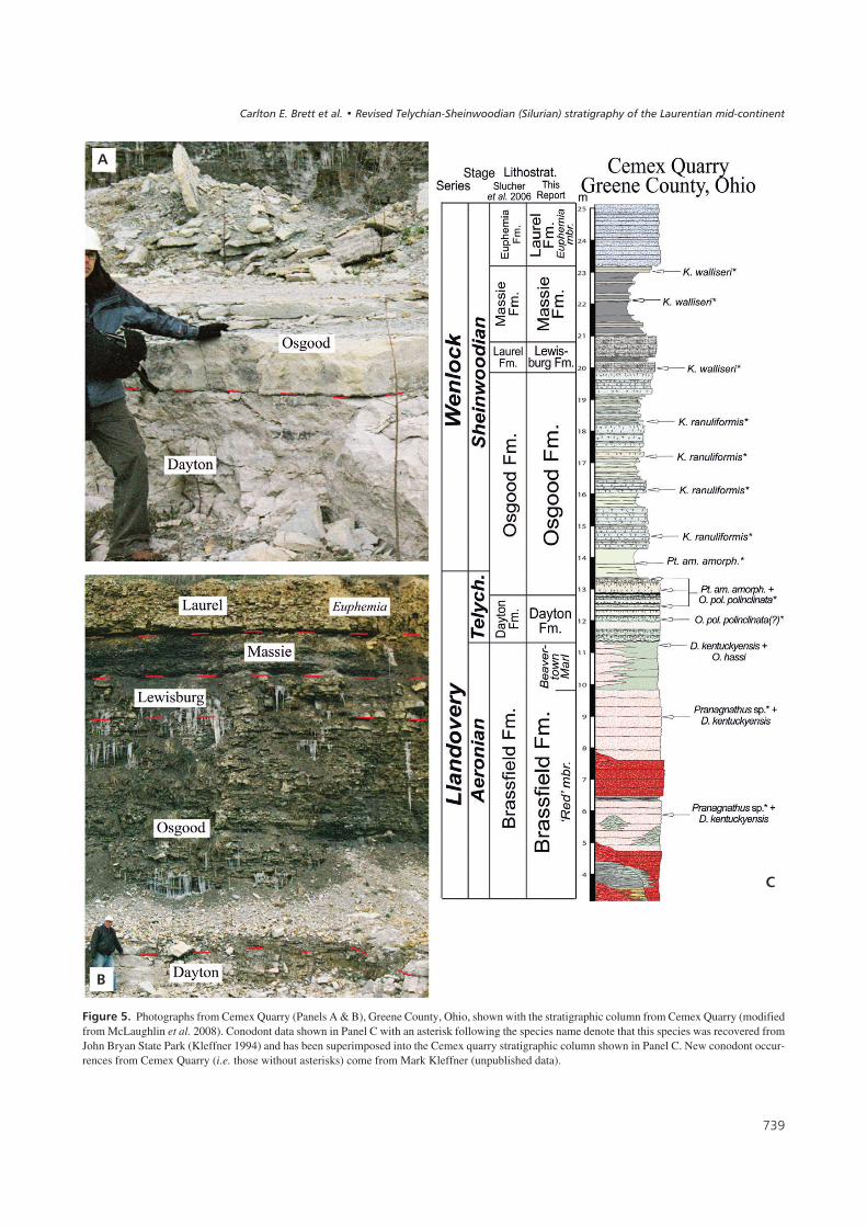
The Cemex Quarry, located in northwestern Greene County,combined with John Bryan State Park, less than 11 km(seven miles) away in northern Greene County (see Schu-macher et al. 2012), expose typical southwestern Ohio strata(Fig. 4) assigned here to the Brassfield, Dayton, Osgood,Lewisburg, Massie, and Laurel formations (Fig. 5). CemexQuarry and John Bryan State Park serve as the revised typelocalities for the Dayton Formation (as revised in this report)and, of the localities included in this transect, are also theclosest to the type area for the term “Massie”, as defined byFoerste in 1929 (<16 km away, see Fig. 2).
The unit referred to as Dayton Formation in GreeneCounty clearly matches the description presented by Norriset al. (1950), and is unequivocally the Dayton of south-western Ohio (see Fig. 4 above). Here, we define theDayton Formation in Greene County, Ohio (Fig. 5A), as adense, glauconitic, dolomicrite that is tabular bedded withphosphatic staining and hardground surfaces throughout(see Revised Lithostratigraphical Terminology below).The Dayton is underlain by the Brassfield Formation andoverlain by the Osgood Formation exclusively. Strata be-longing to the Dayton Formation (as redefined herein) dis-play two characteristics that can be used to identify trueDayton from calcareous Osgood higher up the arch. First,the Dayton Formation is much better indurated and is amore pure dolomicrite. Where the Osgood is more calcare-ous farther up the arch, its argillaceous character is be-trayed by its fracture pattern after blasting (see BarrettQuarry below) or by its tendency to weather more easilythan the overlying Lewisburg strata. Second, the Wenlock,the Dayton Formation, as defined herein, does not extend
��-
����������� ������ �������������
��.
"������.$ Photographs from Cemex Quarry (Panels A & B), Greene County, Ohio, shown with the stratigraphic column from Cemex Quarry (modifiedfrom McLaughlin et al. 2008). Conodont data shown in Panel C with an asterisk following the species name denote that this species was recovered fromJohn Bryan State Park (Kleffner 1994) and has been superimposed into the Cemex quarry stratigraphic column shown in Panel C. New conodont occur-rences from Cemex Quarry (i.e. those without asterisks) come from Mark Kleffner (unpublished data).
&
!
������ ������� ����� ����� �� ��!�"���#$"���%����&$�������' �����(��)"!��"�*���������+��#��������
into the Wenlock. The Dayton Formation sensu strictocontains both Ozarkodina polinclinata polinclinata andPterospathodus amorphognathoides amorphognathoides,as does the base of the overlying Osgood Formation(Fig. 5), indicating that the Dayton Formation is restrictedto the middle (?) to upper part of the Telychian below theonset of the early Sheinwoodian δ13Ccarb excursion.
The new conodont data from Cemex Quarry provided byMark Kleffner, combined with the conodont data ofKleffner (1994) from the very similar succession at JohnBryan State Park, help to demonstrate the magnitude of theunconformity between the Brassfield and the Dayton insouthwestern Ohio. The presence of Distomodus kentuc-kyensis and Pranognathus sp. demonstrate an early to midAeronian age for the top of the Brassfield in Greene County,Ohio, and O. pol. polinclinata demonstrates a mid(?) to lateTelychian age for the Dayton indicating that several millionyears are likely missing at this contact (cf. Cramer et al.2011). The base of the Sheinwoodian is located in the lowerpart of the Osgood Formation, just above the basal carbonateshown in Fig. 5A. Because the outcrops of John Bryan StatePark have been exposed to the elements longer than those ofCemex Quarry, the differential weathering of the Osgood,
Lewisburg, and Massie formations is better developed at thepark than in the Cemex Quarry high-wall (compare Fig. 5with Schumacher et al. 2012). The Massie Shale exposed atCemex Quarry and John Bryan State Park is unmistakablythe Massie Shale first described from Greene County, Ohio,by Foerste (1929).
" ������ � ���&��� ��������&����
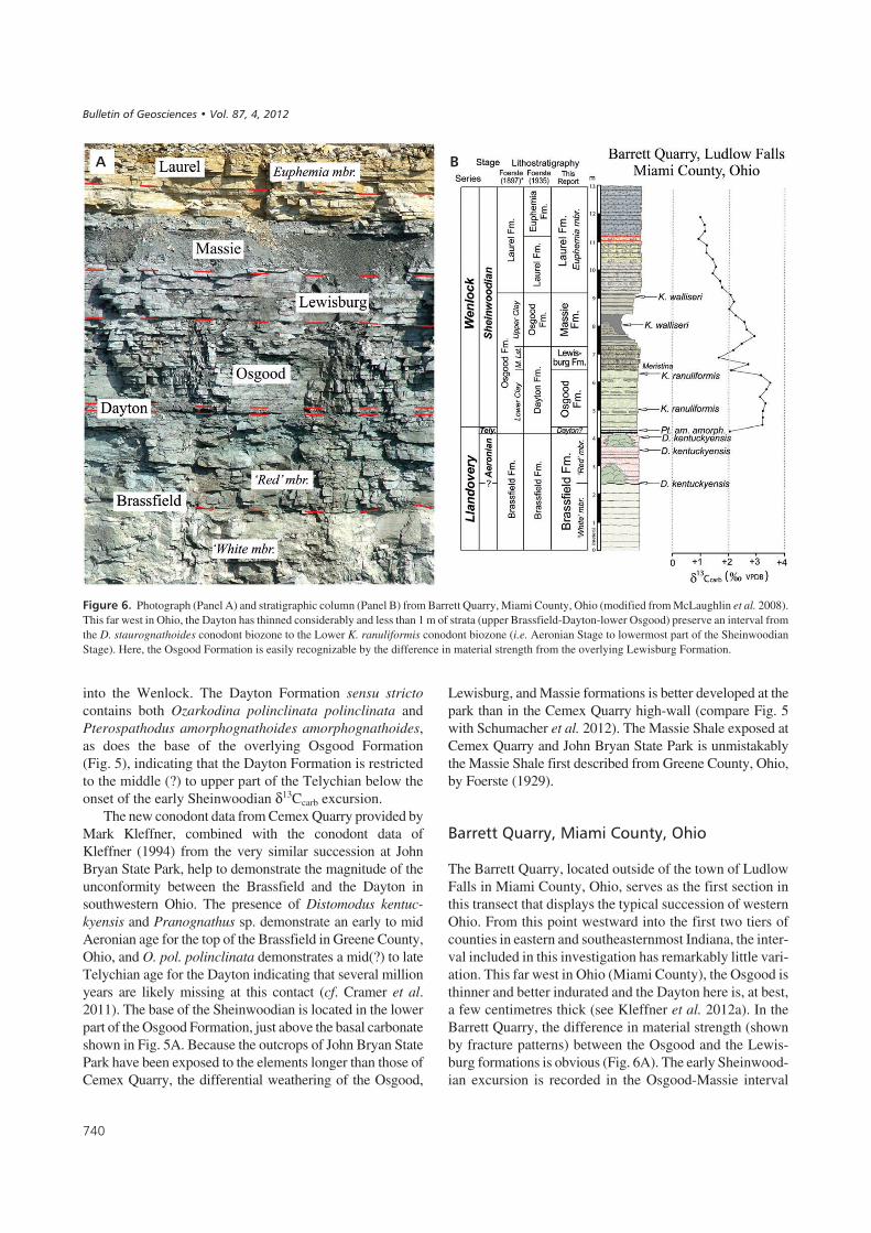
The Barrett Quarry, located outside of the town of LudlowFalls in Miami County, Ohio, serves as the first section inthis transect that displays the typical succession of westernOhio. From this point westward into the first two tiers ofcounties in eastern and southeasternmost Indiana, the inter-val included in this investigation has remarkably little vari-ation. This far west in Ohio (Miami County), the Osgood isthinner and better indurated and the Dayton here is, at best,a few centimetres thick (see Kleffner et al. 2012a). In theBarrett Quarry, the difference in material strength (shownby fracture patterns) between the Osgood and the Lewis-burg formations is obvious (Fig. 6A). The early Sheinwood-ian excursion is recorded in the Osgood-Massie interval
� �
"������/$ Photograph (Panel A) and stratigraphic column (Panel B) from Barrett Quarry, Miami County, Ohio (modified from McLaughlin et al. 2008).This far west in Ohio, the Dayton has thinned considerably and less than 1 m of strata (upper Brassfield-Dayton-lower Osgood) preserve an interval fromthe D. staurognathoides conodont biozone to the Lower K. ranuliformis conodont biozone (i.e. Aeronian Stage to lowermost part of the SheinwoodianStage). Here, the Osgood Formation is easily recognizable by the difference in material strength from the overlying Lewisburg Formation.
&!
����������� ������ �������������

and values decline through the top of the Massie Forma-tion, continuing down below +2.0‰ into the Euphemiamember of the Laurel Formation (revised usage here).
������ � ���&�$�����������&����
The Wysong Quarry, located just south of the town ofLewisburg in Preble County, Ohio (Fig. 2), is 2.4 km(1.5 miles) south-southeast of the original type locality ofthe Euphemia (Foerste 1917) and serves as the type localityfor the Lewisburg Formation. New and previously publis-hed conodont data from Kleffner (1994) are shown inFig. 7B. Based upon physical stratigraphy, conodont bio-stratigraphy, and carbon isotope chemostratigraphy, thereis extremely limited variability between the Piqua and Bar-rett quarries in Miami County, Ohio, heading southwest-ern to Wysong Quarry in Preble County, Ohio.
Moving northwest from Cemex and John Bryan inGreene County, Ohio (the revised type area of the DaytonFormation), toward the apex of the arch and thinner succes-sions of western Ohio, the Dayton Formation (as redefinedhere) thins appreciably to the point where it virtually disap-pears (Kleffner et al. 2012a), being represented by only a
few centimetres of extremely phosphate-rich or iron-stained dolostone (Fig. 7A). For this reason, we suggestthat the Dayton Formation extends slightly into Indiana asa thin reddish band at the base of the Osgood Formation,previously, but incorrectly, identified as the Lee CreekMember of the Brassfield Formation (see below).
It is important to note that throughout Greene, Miami,and Preble counties, it can be demonstrated quite clearly thatthe conodont biostratigraphy of the Osgood-Lewisburg-Massie succession in southwestern Ohio is identical to thatin western Ohio. The Osgood Formation (our usage) con-tains Kockelella ranuliformis, indicative of an earliestSheinwoodian age, whereas the Lewisburg Fm. and MassieFm contain Kockelella walliseri indicative of mid to lateSheinwoodian age. Stable isotope (δ13Ccarb) chemo-stratigraphy supports this correlation of the Osgood-Lewis-burg-Massie succession to the lower-middle part of theSheinwoodian Stage.
( ����� � ���&�)�����������&�*�� �
The type area for the term “Osgood”, as defined by Foerste(1897), is in and around the town of Osgood in Ripley
� �
"������0$ Photograph of Piqua Quarry, Miami County, Ohio (Panel A), and stratigraphical column (Panel B) from Wysong Quarry, Preble County,Ohio (modified from McLaughlin et al. 2008). Southwest from Miami County to Preble County, the stratigraphy is remarkably consistent (compare PanelB with Fig. 4B), however northwest from the city of Dayton, Ohio, the stratigraphy thins markedly. The Dayton Formation virtually disappears and theOsgood Formation becomes much more calcareous. Based upon conodont biostratigraphy and carbon isotope chemostratigraphy, the thin black phos-phatic lag shown in Panel A is all that remains of the Dayton Formation to the north or west of Montgomery County, Ohio.
&!
������ ������� ����� ����� �� ��!�"���#$"���%����&$�������' �����(��)"!��"�*���������+��#��������

County, Indiana. The Napoleon Quarry (Fig. 8) is locatedapproximately 10 km (6 miles) north-northwest of the townof Osgood and, of the sections included in this study, it isthe closest to Foerste’s Osgood type area. From its typearea (northwest-central Ripley County, Indiana), Foerste(1897) described a tripartite division of the Osgood Forma-tion: a Lower Osgood Clay, a Middle Osgood Limestone,and an Upper Osgood Clay. The Napoleon Quarry clearlydemonstrates the transition from Foerste’s usage of Os-good (which is still used by the Indiana Geological Sur-vey – although as a member of the Salamonie Formation;Shaver et al. 1986) to the restricted sense of the term pre-sented here, as well as how the terms Massie and Lewis-burg fit into Foerste’s original classification. Herein, theterm Osgood is restricted entirely to Foerste’s Lower Os-good Clay. His Middle Osgood Limestone is effectivelythe Lewisburg Formation and the Massie Formation is ef-fectively Foerste’s Upper Osgood Clay.
It should be noted that herein we have chosen to placethe top of the Massie at the point above which no furtherinterbeds of shale occur. Occasionally, the interbedded up-per part of the Massie (Foerste’s “Burrowed Laurel”) is pre-served as a single or sometimes two beds of amalgamated
burrow fills (Fig. 8A). In such cases, these galleries are in-cluded here within the Massie Formation. A more definitivestatement about this boundary (top Massie-base Laurel) willhave to await future revisions to the Laurel Formation.
Figure 8A shows the lower wall of the quarry, whichexposes the entirety of Foerste’s (1897) Osgood Forma-tion. Nicoll & Rexroad (1968) identified a thin carbonateunit between the Brassfield and Osgood in southeasternIndiana that they termed the “Lee Creek Member of theBrassfield Formation”. They suggested that the Lee CreekMember could be traced as far north as Ripley andDecatur counties, occurring as a thin red band at the baseof the Osgood (Fig. 8). As in western Ohio and mentionedearlier, however, based upon conodont biostratigraphy,these thin horizons are likely the westward equivalent ofthe Dayton Formation and not their Lee Creek Member(see below).
� ����) ���&�!�++����������&�*�� �
The large roadcut on US 421, north of Madison, Indiana,serves as the best representative section for the revisions to
� /
"������1$ Photograph (Panel A) and stratigraphical column (Panel B) from Napoleon Quarry, Ripley County, Indiana (modified from McLaughlin et al.2008). In this quarry, the “burrowed Laurel” is placed within the uppermost part of the Massie Formation (see text). Similarly, the basal carbonate unit ofthe Massie Formation is well exposed in this quarry and serves as the foundation for the small bioherms that protrude into the shales of the Massie Forma-tion in this quarry.
&!
����������� ������ �������������

� �
"������2$ Photographs from the Madison Roadcut, Jefferson County, Indiana. The Lee Creek Formation (Panel A) is a clearly distinct unit from the under-lying Brassfield Formation. As the Osgood thickens south from Ripley County into Jefferson County, the basal carbonate unit of the Osgood Formation be-come more readily identifiable (Panel A). This section is nominated here as a parastratotype for the Lewisburg and Massie formations (Panels C & D).
&
'
!
������ ������� ����� ����� �� ��!�"���#$"���%����&$�������' �����(��)"!��"�*���������+��#��������

the terms used herein and displays strong similarities withthe Cemex Quarry and John Bryan State Park. The sectionshows expansion relative to Napoleon Quarry and, as wasthe case with moving southeast from Preble and Miamicounties in Ohio into Greene County, the first interval tobegin thickening is the Osgood Formation (Fig. 9B). All ofthe units are thicker in southeast Indiana than higher up onthe arch in the previous localities. The true Lee Creek Mem-ber is present for the first time (Fig. 9A) in this transect, andthis locality is ~16 km (10 miles) from the type section ofthe Lee Creek defined by Nicoll & Rexroad (1968). Theconodonts recovered from the Lee Creek Formation, iden-tified by Nicoll & Rexroad (1968) as Pterospathodus cel-loni, have since been reclassified by Männik (1998) asPt. eopennatus indicating that the Lee Creek Formationcorrelates to a position within the middle part of the Tely-chian Stage. Although not recovered from this exposure,Nicoll & Rexroad (1968) recovered Pt. eopennatus fromseveral localities in Jefferson County, Indiana, all of whichwere within 13 km (8 miles) of this section. This is conside-rably below the higher Telychian position indicated byPt. am. amorphognathoides and O. polinclinata polincli-nata for the Dayton Formation of southwestern Ohio andrepresents stratigraphy not preserved at the unconformitybetween the Brassfield and the Dayton in Greene County,Ohio (e.g. Cemex Quarry).
Nicoll & Rexroad (1968) designated the Lee Creek as amember of the Brassfield Formation; it is herein removedfrom the Brassfield and raised in rank to formation. In thissection, however, the base of the overlying Osgood Forma-tion is marked by a thin carbonate containing Pt. am.amorphognathoides and O. pol. polinclinata, exactly likethe thin carbonate at the base of the Osgood Formation atCemex Quarry in Greene County, Ohio. Therefore, in thissection, there are no Dayton-equivalent strata. The olderLee Creek Formation appears to occupy this stratigraphicalposition (between the Brassfield and Osgood) throughoutsouthern Indiana and west-central Kentucky.
This locality serves as the Indiana stratotype for the re-vised terminology presented here (Lee Creek, Osgood,Lewisburg, Massie, Laurel). The sharp surface separatingthe basal carbonate unit of the Massie Formation is welldemonstrated at this locality (Fig. 9D). Conodonts recov-ered from Madison Roadcut (Fig. 10) were identifiedby Mark Kleffner (unpublished data). The presence ofD. staurognathoides at the top of the Osgood in this sectionlimits the uppermost part of the Osgood to, at highest, theLower K. ranuliformis Zone.
�����,&���� �������&�-�����%�
The Crestwood section (referred to as Park Lake byMcLaughlin et al. 2008) is located just northeast of the
Louisville metropolitan area in Oldham County, Kentucky.The Crestwood Composite contains the early Sheinwoodianδ13Ccarb excursion (Fig. 10B), showing the same pattern asBarrett Quarry in Miami County, Ohio, with isotope valueselevated and rising in the Osgood and declining through thetop of the Massie Formation. The δ13Ccarb data from Crest-wood, Kentucky, and Barrett Quarry, Ohio, combined withthe conodont data from Wysong Quarry and John BryanState Park, Ohio, in addition to the physical stratigraphyprovided throughout, demonstrate the reliability of the revi-sed chronostratigraphical correlations within the study areaof this report. As a result, we can resolve more than a centuryof stratigraphical confusion by applying a consistent strati-graphical terminology across the region.
������������������ ����������� ���
����������
The revisions to Cincinnati Arch lithostratigraphical ter-minology presented in this report are summarized belowfor each state. A revised lithostratigraphical chart is pro-vided for the Indiana-Kentucky-Ohio Tristate area(Fig. 11) that includes the currently accepted nomencla-ture in use in each state. We also present a brief compen-dium that includes the history, use, description and a fewnotes on correlation of the revised lithostratigraphicalterms used herein.
#���� ������*�� �
The revisions made to the Telychian and Sheinwoodianstrata of eastern and southeastern Indiana are shown inFig. 11 and are summarized as follows: 1) The Lee CreekMember has been removed from the Brassfield Formationand raised in rank as the Lee Creek Formation. Tempo-rally, the unconformity between the Lee Creek and theBrassfield is likely as significant, if not more so, than theunconformity between the Lee Creek and the overlyingOsgood. 2) The term Osgood is restricted herein tothe “Lower Osgood Clay” of Foerste (1897). 3) The termLewisburg Formation is formally introduced as equiva-lent to the “Middle Osgood Limestone” of Foerste (1897).4) The Massie Formation herein is Foerste’s (1897)“Upper Osgood Clay” with the uppermost bed of his “Os-good Limestone” (our Lewisburg) marking the base of theMassie Formation. 5) The base of the Laurel Formation isherein defined as the point above which no further shaleinterbeds occur. If the beds in question are composed ofamalgamated burrow gallery fillings, the base of the Lau-rel is placed at the top of the burrowed unit, making theprevious term “Burrowed Laurel” the uppermost part ofthe Massie Formation herein.
�
����������� ������ �������������

���������� ��-�����%�
The revisions to the lithostratigraphical nomenclature ofwest-central Kentucky are comparatively minor, owing inlarge part to the fact that only two terms were presently inuse (Osgood and Laurel). The revisions made to the defi-nition of lithostratigraphical terms used in west-centralKentucky are presented in Fig. 11 and summarized as fol-lows: 1) The term Lewisburg Formation should replacesubunit 1 of the Laurel Formation (sensu Peterson 1986).2) The term Massie Formation should replace Peterson’s(1986) subunit 2 of the Laurel Formation. 3) The unit re-ferred to as the Lee Creek Member of the Brassfield For-mation is clearly recognizable, and for the reasons discus-sed above, should be removed as a member from theBrassfield, and similar to southern Indiana, should be re-cognized in west-central Kentucky as the Lee Creek For-mation.
�������� ��#���,����������
The revised lithostratigraphical chart for western and south-western Ohio is presented in Fig. 11, and the revisionsmade to the definition of lithostratigraphical terms used inthis region are as follows: 1) The Dayton Formation redefi-ned herein is restricted to a 0.5 to 2.5m-thick unit that over-lies the Brassfield Formation and underlies the OsgoodFormation in southwestern Ohio (E Montgomery, Greene,SW Clark counties). In western Ohio (Preble, NW Mont-gomery, Miami, and Darke counties), the term Dayton hashistorically been used to refer to the Osgood and Lewis-burg formations of this report. The term Dayton is here re-stricted geographicalally to western and southwesternOhio, and is used in its southwestern Ohio sense (see Day-ton problem above), and is exclusively overlain by the Os-good Formation. Use of the term “Dayton Formation” in itsprevious western Ohio usage is herein abandoned. 2) In
� +
"������#3$ Stratigraphical columns for Madison Roadcut (Panel A), Jefferson County, Indiana, and Crestwood (Panel B), Oldham County, Kentucky(both modified from McLaughlin et al. 2008). Comparison between these two sections illustrates that the stratigraphical pattern see throughout this studycontinues southward into central Kentucky. Similarly, the carbon isotope profile from the Crestwood section confirms the correlation between the south-ernmost and northernmost areas of this study. Red wavy line at base of Brassfield in Ordovician-Silurian unconformity.
&!
������ ������� ����� ����� �� ��!�"���#$"���%����&$�������' �����(��)"!��"�*���������+��#��������

western Ohio, the Massie Shale has frequently been referredto as the entirety of the Osgood Formation in Ohio. This isclearly Foerste’s (1897) “Upper Osgood Clay”, and no lon-ger is associated with the Osgood Formation, as redefined inthis report. The term Massie Formation should replace theterm “Osgood Formation” (used in a restricted sense) inwestern Ohio. 3) Use of the term Laurel within Ohio is rede-fined to match that of its type area in Indiana. The term andconcept of “Laurel of Ohio” (e.g. Berry & Boucot 1970) arehere abandoned. 4) We formally introduce the term Lewis-burg at the rank of formation to refer to strata previously as-signed to the Middle Osgood Limestone in western Ohio(e.g. Kovach 1974) or the Laurel Formation in southwesternOhio (Slucher 2004; Slucher et al. 2006; Schumacher et al.2012). Throughout the study area of western and southwest-ern Ohio, this lithostratigraphical unit should be referred toas the Lewisburg Formation. 5) The Euphemia and Spring-field, and possibly the Cedarville appear to occupy the samestratigraphical position as the Laurel of Indiana; middleSheinwoodian to middle Homerian spanning the intervalbetween the early Sheinwoodian and middle Homerian andpositive δ13Ccarb excursions. These Ohio units may makeviable members of the Laurel Formation in the future; how-ever, formalization of such changes is beyond scope of thecurrent report and must await further study.
���������� ����������� �
In the following sections we discuss the principal units ofmid Telychian to early Sheinwoodian strata that overlie the
Brassfield Formation in southwestern Ohio, southeast Indi-ana, and west-central Kentucky. The units are discussed inapproximate ascending chronostratigraphical order.
��������%���� ���
Type area and history. – Introduced by Nicoll & Rexroad(1968) as the uppermost member of the Brassfield Formationin southeastern Indiana, the term Lee Creek is herein remo-ved from the Brassfield and raised in rank to be the LeeCreek Formation. The type area and reference sections ofNicoll & Rexroad (1968) are retained but its recognition ishere restricted to the area south of central Ripley County,Indiana.
Description. – The Lee Creek Formation is underlain bythe Brassfield Formation and overlain by the Osgood For-mation and can be identified throughout southeastern Indi-ana and adjacent areas of Kentucky as a thin to lenticular-bedded, orange-weathering, green to tan, phosphatic andglauconitic silty dolomudstone to dolocalcisiltite. The LeeCreek Formation is typically less than 1 m thick (often<50 cm), displays extensive bioturbation, and has an undu-lating, irregular, sharp lower surface that is often heavilymineralized. This irregular lower surface marks the contactbetween the Brassfield Formation and the Lee Creek For-mation.
Correlation. – Conodonts recovered from the Lee Creek byNicoll & Rexroad (1968) have been reclassified by Männik(1998, 2007) as Pt. eopennatus in modern nomenclature in-dicating that the Lee Creek Formation correlates to a posi-tion within the middle part of the Telychian Stage. Thereare no Lee Creek-equivalent strata preserved on the Cin-cinnati Arch in eastern Indiana. Strata from Brown Countyin southern Ohio contain conodonts indicative of the Pt.eopennatus Superzone (M. Kleffner, unpublished data)and suggest that as one moves down ramp into the Appala-chian Basin at least some Lee Creek-equivalent strata be-gin to come in (i.e. Waco Formation), but on the apex of theCincinnati Arch throughout the study area of eastern Indi-ana and western Ohio, there are no strata that correlate withthe Lee Creek Formation (see Kleffner et al. 2012a).
� ������� ���
Type area and history. – The Dayton Formation was ori-ginally designated by Orton (1870) for strata exposed inthe Dayton area of Montgomery County, Ohio. No typesection was designated, and most of the original quarriesthat worked Orton’s original “Dayton” are no longer ac-cessible or have removed the exposed Dayton entirely.
� ,
"������##$ Summary of stratigraphical revisions to the Osgood-Laurelinterval of the Tristate area including the original use of Osgood and Lau-rel (Foerste 1897), the currently accepted Indiana terminology (Shaver etal. 1986), the currently accepted terminology for west-central Kentucky(Peterson 1986), the historically important but currently disused terminol-ogy from western Ohio (Foerste 1935), the currently accepted terminol-ogy for Ohio, and the revisions proposed here shown at the far right. Thethrough-going nature of these units across the study area illustrates that asimple and consistent terminology is both applicable and justifiedthroughout the Indiana-Kentucky-Ohio Tristate area.
����������� ������ �������������

Orton originally suggested that the Dayton ranged from 5to 50 ft in thickness, and used the term to refer to what arenow recognized to be a number of different lithostratigrap-hical units throughout Ohio.
Description. – The Dayton Formation as defined by Norriset al. (1950) referred to a unit in Greene County, Ohio, un-derlain by the Brassfield Formation and overlain by theOsgood Formation: “The Dayton is a hard white limestoneabout 8 ft. thick and occurs in thin, well-defined beds”(Norris et al. 1950). The Dayton, as defined herein, is adense, white to pale, grey-green, glauconitic, tabular tothin-bedded dolomicrite that contains extensive phosphaticstaining, phosphatic horizons, and pyrite throughout. North-west of the revised type area in Greene County, the DaytonFormation thins rapidly and by western Miami County,Ohio, and Preble County, Ohio, the entire Dayton is repre-sented by a thin, black-stained, phosphatic lag deposit<10 cm thick fused to the base of the overlying Osgood(Kleffner et al. 2012a). By the Indiana border, this lag is re-presented by a red-stained interval at the base of the Os-good Formation that is <5 cm thick.
Biostratigraphy and correlation. – Uppermost Daytonstrata contain the conodonts Pterospathodus amorpho-gnathoides amorphognathoides and O. polinclinata polin-clinata indicating that the Dayton Formation does not ex-tend into the Wenlock, and is restricted to the TelychianStage of the Llandovery Series. The lower limit of the Day-ton is not as well defined, but is no younger than middle Te-lychian in age. There is no Dayton equivalent in southeas-ternmost Indiana and adjacent Kentucky. Dayton stratasensu stricto contain δ13Ccarb values between +1.0‰ and+2.0‰ throughout the study area (Cramer 2009) below theonset of the early Sheinwoodian excursion.
Discussion. – The name Dayton has also been used to referto strata as far to the east as western West Virginia that liebelow the Estill Formation (e.g. Horvath 1969, Ryder2006). As used prior to this report, the term Dayton there-fore referred to a variety of strata occupying a variety ofchronostratigraphical positions and representing a widerange of lithologies. Its only consistency in meaning wasits stratigraphical position above the Brassfield and beloweither the Estill Formation or Osgood Formation. Herein,the type area of the Dayton is moved to Greene County(Cemex Quarry and John Bryan State Park), its definitionis revised as a unit exclusively overlain by the Osgood For-mation, and use of the term Dayton is returned nearly to thedefinition of Norris et al. (1950), which appears to be theoldest workable definition of a Dayton Formation in south-western Ohio. The Dayton Formation as defined herein isnot recognized southeast of northwestern Clinton County,Ohio or west of the easternmost tier of counties in Indiana.
������� ���
Type area and history. – Introduced by Foerste (1897) andnamed for the town of Osgood in Ripley County, Indiana,the Osgood Formation has been recognized throughoutmuch of the Laurentian mid-continent. Foerste’s originaluse of the term included a “Lower Osgood Clay”, a middle“Osgood Limestone”, and an “Upper Osgood Clay”. How-ever, the term “Osgood” has not been equally applied. Inwestern Ohio for instance, Foerste himself restricted histerm Osgood Formation in Ohio (in its entirety) to refer ex-clusively to the “Upper Osgood Clay” of the Indiana typesections (Foerste 1935, p. 162), whereas in southwesternOhio (e.g. Greene County) and west-central Kentucky,only the “Lower Osgood Clay” was referred to as the Os-good Formation.
Type and reference sections. – Exposures at Osgood, Indi-ana are presently poor and the Osgood Formation is onlyobservable in tailings from the now water-filled OsgoodQuarry. However, the interval is very well exposed farthersouth on an unnamed tributary of Indian-Kentuck Creek insouthern Ripley County, Indiana, and at the large highwaycuts on US Rte 421 north of Madison, in Jefferson County,Indiana (Madison Roadcut, Fig. 10A herein, also seeMcLaughlin et al. 2008). These sections serve as excellentsurrogates for the incomplete sections at Osgood itself. Ot-her excellent sections are seen in roadcuts on I-71 near restareas on both the north and southbound lanes and nearbyon Rte. 329 both north of Crestwood, Oldham County, KY(Fig. 10B herein, also see McLaughlin et al. 2008), and atthe Cemex Quarry near Fairborn, Greene County, Ohio.
Thin calcareous lower to middle Osgood Formation,formerly termed “Dayton” in western Ohio (Foerste 1935),is well exposed at the Barrett Paving Quarry, Ludlow Falls,Ohio, the Wysong Stone Quarry at Lewisburg, PrebleCounty, Ohio, the Napoleon Stone Quarry at Napoleon, In-diana and at New Point Stone Quarry, New Point, Indiana(Figs 6, 8, herein, also see McLaughlin et al. 2008).
Description. – The Osgood Formation, as revised herein, isunderlain by the Lee Creek Formation in southeastern Indi-ana and adjacent Kentucky, by the Brassfield Formation ineastern Indiana, by a thin, phosphatic Dayton Formationtypically <10 cm thick in western Ohio, and by the DaytonFormation in the Dayton’s revised type area of GreeneCounty, Ohio. The Osgood Formation is overlain by theLewisburg Formation throughout the study area. In south-eastern Indiana, Foerste’s original type area, the OsgoodFormation (as revised here) is typically 3–4 m thick, con-sisting of what he referred to as “clay or clayey shale, vary-ing locally to an argillaceous limestone, or even to thin lay-ers of rubbly limestone” (Foerste 1897, p. 227). Acrossthe study area, the Osgood Formation becomes much better
� �
������ ������� ����� ����� �� ��!�"���#$"���%����&$�������' �����(��)"!��"�*���������+��#��������

indurated and begins to lose its shale character to the north(Foerste’s rubbly limestone) and returns to the typical in-terbedded marlstones, dolocalcisiltites, dolowackestones,and olive-grey shales moving into southwestern Ohio andsoutheastern Indiana. In places, significant pyritization andrusty staining is found in distinct horizons within the upperpart of the Osgood Formation in sections where the Osgoodapproaches its maximum thickness.
The Osgood Formation is a distinctive unit in weath-ered exposures because of its strikingly banded light anddark grey, rhythmic bedding. In its thickest areas nearDayton, Ohio or Mt. Washington, Kentucky, the Osgood iscomprised of medium to dark grey, calcareous-dolomiticshaly mudstone interbedded with compact to crumbly ar-gillaceous dolostones. The latter typically also show inter-nal thin wavy laminae. A lower shale interval at Mt. Wash-ington is red, maroon and green clay shale. In moreproximal areas there is a gradual loss of shale until, in areasnear Ludlow Falls, Ohio and Napoleon, Indiana, the inter-val comprises 80–90% argillaceous dolostone and theshales are reduced to relatively thin partings except for thebasal few decimetres.
The carbonates are mainly dolomudstone to dolo-wackestone textures and less dolomitized outcrops showsmall comminuted debris of echinoderm plates and brachi-opod fragments; whole fossils are generally uncommon butbrachiopods, including Eoplectodonta and Atrypa are pres-ent on a few bedding planes. Recent studies have demon-strated abundant trace fossils on bedding planes in parts ofthe Osgood; these include Chondrites and Planolites.However, the unit is not so strongly bioturbated that thethin bedding is destroyed.
Biostratigraphy and correlation. – In thicker Osgood sec-tions, the base of the formation is marked by a thin carbo-nate unit, which has a sharp lower contact and a gradationalupper contact with the rest of the overlying Osgood Forma-tion (informally referred to as the “basal Osgood carbo-nate” herein, Figs 5A and 9A, and Foerste 1931). Foerste’s(1897) definition of a tri-partite Osgood identified the factthat in thicker sections, the base of the “Lower OsgoodClay” is typically marked by a thin carbonate interval(Foerste’s 1897 “Lower Osgood Limestone” or his 1931“Basal Osgood”). This carbonate and the first few centi-metres of overlying strata, contain the conodonts Pt. amor-phognathoides amorphognathoides as well as O. polincli-nata polinclinata. The LAD of O. pol. polinclinata is justabove this basal carbonate, which indicates that the base ofthe Osgood Formation is within the uppermost part of theTelychian Stage. The vast majority of the Osgood Forma-tion however, correlates with the lowermost part of theSheinwoodian Stage. In sections that contain a thinner Os-good, the Telychian is typically represented in the OsgoodFormation by a few centimetres at most (Figs 6, 7). Both
Pt. am. amorphognathoides and O. pol. polinclinata havetheir LADs in lowermost Osgood strata, and the overlyingstrata contain the onset of the early Sheinwoodian δ13Ccarb
excursion.
Discussion. – The Osgood Formation has been designatedas a member of the Salamonie Dolomite in southern Indi-ana (Pinsak & Shaver 1964), and has been reduced in scopeby mapping practice in Indiana and Kentucky. Herein, theterm Salamonie Formation is discouraged south of the Lau-rel type area, and the term “Osgood” is promoted back to itsprevious status as the Osgood Formation throughout theTristate area.
The use of the term “Osgood Formation”, however, isherein restricted exclusively to the interval termed “LowerOsgood Clay” of southeast Indiana (Foerste 1897). In theDayton region (SW Ohio) the name Osgood Formation hasbeen applied in the Kentucky sense as only equivalent tothe Lower Osgood Clay of Indiana; however, in westernOhio (e.g., Ludlow Falls, Lewisburg and New Paris),where the equivalent unit becomes thinner, more dolomiticand shows only thin shale partings, this interval has beentermed “Dayton” and the name Osgood applied only to theshale herein identified throughout the region as the MassieFormation. This inconsistency of usage has caused muchmisunderstanding. We hope to cut through that confusionby applying the term Osgood consistently to a constrainedinterval of thinly bedded, fine-grained carbonates andshales or shale partings. Inasmuch as the same beds andbedsets are identifiable throughout the region despitechanges in thickness and overall carbonate content we be-lieve use of the same name in three states is advisable.
��,���������� ���
Type area and history. – Introduced informally by Kovach(1974) in Preble County, Ohio, to replace effectivelyFoerste’s (1897) “Middle Osgood Limestone”, the termhas never been formally introduced and is not currently inwidespread use. Reintroduced by McLaughlin et al. (2008)as Kovach (1974) used it, the term “Lewisburg” is utilizedby this report and is similarly given formational rank. TheLewisburg Formation as defined here is nearly equivalentto its original use (to replace Foerste’s “Middle Osgood Li-mestone”) with the exception of the uppermost bed ofFoerste’s Osgood Limestone and Kovach’s Lewisburg (of-ten with a distinct surface at its base, Fig. 9D) being remo-ved and referred to herein as belonging to the overlyingMassie Formation throughout the study area.
Description. – The Lewisburg Formation is underlain bythe Osgood Formation (as revised herein) and is overlainby the Massie Formation (as revised herein). Foerste
� -
����������� ������ �������������

(1897) described what is now termed the Lewisburg For-mation as follows: “Above the Lower Osgood clay bed orits equivalents [Osgood Formation herein]..., there is al-most everywhere a layer or number of layers of limestone,very crinoidal in character, and usually presenting fossilson its upper surface and in the intercalated clay beds”(Foerste 1897, p. 229). The years of field work leading tothe publication of McLaughlin et al. (2008) included a ma-jor effort to trace this formation throughout the currentstudy area. The type section for the Lewisburg Formationis herein placed at the Wysong Quarry, just south of thetown of Lewisburg in Preble County, Ohio. McLaughlin etal. (2008) described the Lewisburg Formation from its re-vised type section as “~1 m of amalgamated, dolomiticpackstone-grainstone divided in half by ~10 cm of grayshale and thin, lenticular, fine-grained grainstones......Macrofossils are difficult to identify in this unit and arecomposed mostly of crinoid columnals...”. The parastrato-type for the Lewisburg is placed at the Madison Roadcut inJefferson County, Indiana (Fig. 9C).
The Lewisburg Formation is comprised of pale grey- tobeige-weathering fossiliferous dolostone or limestoneabout 0.5 m to 4 m thick. In many localities across south-eastern Indiana the Lewisburg Formation comprises coarseechinoderm pack- to grainstone. The brachiopods Atrypaand Meristina (formerly Cryptothyrella) cylindrica areparticularly typical of the Lewisburg interval. Throughoutmuch of its outcrop, the Lewisburg is tripartite (Fig. 9C),with a lower generally medium to thick bedded compactdolo-wacke to packstone, a middle argillaceous and nodu-lar interbedded mudstone/dolostone, and an upper fos-siliferous limestone/dolostone. Generally, this interval ismore fossiliferous than underlying strata.
The basal unit, informally unit A, is pale yellowish greyand weathers pale buff. In certain localities, notably nearDayton, Ohio the basal unit is vuggy and displays moulds ofbrachiopods and crinoid debris. The middle division, unit B,of the Lewisburg Formation is generally more argillaceousand typically weathers as irregularly bedded nodular torubbly limestone/dolostone with much interbedded mediumgrey mudstone. The upper or C division of the LewisburgFormation is more compact, typically about 0.5 m to 1 mthick and is typically the most fossiliferous unit of the for-mation. In places this interval is depressed and slightly de-formed underneath local micritic bioherms that extend intothe overlying Massie Shale. The Lewisburg Formation isrelatively thin toward the northern extent of the study area inIndiana, and western Ohio and the tripartite nature of the unitbecomes somewhat obscured, although a more compact topbed is almost always recognizable.
Biostratigraphy and correlation. – The base of the Lewis-burg is within the Upper K. ranuliformis Conodont Zoneand above the onset of the early Sheinwoodian δ13Ccarb
excursion. The stratigraphically important conodont K. wal-liseri first occurs in the study area within the LewisburgFormation indicating an early-mid Sheinwoodian age (seeCramer et al. 2010b).
Discussion. – Kovach (1974) introduced the term “Lewis-burg” to refer to Foerste’s “Middle Osgood Limestone”,and Kovach’s use is essentially retained herein. We hereinresurrect this name as a formation-scale unit to be appliedat least from Greene County, Ohio westward to the firsttwo tiers of counties in southeast Indiana and from there,south through west-central Kentucky. The strata hereintermed Lewisburg correspond to a portion of what was re-ferred to in much past literature as “Laurel of Ohio” (e.g.Foerste 1929, Berry & Boucot 1970, Slucher 2004, Slucheret al. 2006, Schumacher et al. 2012) from John Bryan StatePark northwestward to near the Indiana State line. In Indi-ana, the interval has generally been referred to as the “Mid-dle Limestone” of the Osgood (Foerste, 1897), even thoughit is generally a dolostone. In Kentucky, the name Lewis-burg Formation should replace subunit 1 of the Laurel For-mation (Peterson 1986).
� �������� ���
Type area and history. – Introduced by Foerste (1929) torefer to the medium to dark grey shales underlying the Eup-hemia Formation exposed along Massie Creek, west ofthe town of Cedarville in Greene County, Ohio, the termMassie is in current use at the rank of formation withinOhio (Slucher 2004, Slucher et al. 2006) as the Massie For-mation, and formational rank is retained herein. As a repla-cement for Foerste’s (1897) “Upper Osgood Clay”, theMassie Formation can be identified throughout the presentstudy area as the upper Osgood of Indiana, the Osgood ofwestern Ohio, subunit 2 of the Laurel Formation in Ken-tucky, or the Massie Formation in southwestern Ohio. He-rein the name is extended from the type area in GreeneCounty, Ohio, northwest at least as far as the exposures atLudlow Falls, Lewisburg and New Paris, Ohio at the stateline and thence westward into Indiana at least to DecaturCounty, Indiana, and southward through west-central Ken-tucky at least as far as the Louisville area.
Description. – The Massie Formation is underlain by theLewisburg Formation, and overlain by the informal Euphe-mia member of the Laurel Formation (see Laurel entry be-low). The Massie Formation in Foerste’s original type area(Greene County, Ohio) is typically a 2 m-thick dark greycalcareous shale with thin, lenticular, argillaceous dolo-wackestones and dolocalcisiltites. This dark grey shale fa-cies represents the majority of the Massie Formationthroughout the study area. However, the base of the Massie
� .
������ ������� ����� ����� �� ��!�"���#$"���%����&$�������' �����(��)"!��"�*���������+��#��������

Formation, as defined herein, is a thin carbonate unit with atypically distinct lower surface separating it from the un-derlying Lewisburg Formation (Fig. 9D). The top of theMassie Formation is defined here by the base of the LaurelFormation, which has been placed at the position abovewhich no further interbedded thin, tabular dolostone and do-lomitic shales occur. In the event that the beds in questionsare amalgamated burrow galleries (i.e. the so-called bur-rowed Laurel), the base of the Laurel (and top of the Mas-sie) is placed at the top of these beds.
At its type section, near Cedarville, Ohio, the MassieShale attains thicknesses of up to 3 m and is a fossiliferousgrey shale; in the Wysong Quarry at Lewisburg, Ohio, theMassie Shale is composed of approximately 1 m of darkgrey dolomitic shale and tan, thin to medium beddeddolocalcisiltites to dolomarlstones. Rusty spotting occurslocally within the grey shales. At Napoleon Quarry theMassie is composed of approximately 1 m of dark to me-dium grey, dolomitic shales and light grey dolocalcisiltitesand dolowackestones. This unit contains a relatively di-verse fauna that is notable for its diverse echinoderm fau-nas, including a high diversity of diploporitan cystoids,coronoids, one of the youngest eocrinoids and the youngestknown paracrinoids (see Frest et al. 1999, 2011).
Biostratigraphy and correlation. – The Massie Formationcontains the conodont Kockelella walliseri and the fallinglimb of the early Sheinwoodian δ13Ccarb excursion indica-ting a mid Sheinwoodian age for this unit. δ13Ccarb valuesdecline to below +2.0‰ across the contact between theMassie Formation and the overlying Laurel Formationthroughout the study area marking the end of the excur-sion.
Discussion. – A wide variety of different names have beenapplied to this shale unit despite its consistent lithology andsimilar thicknesses over a very large region. Foerste (1897)referred to this shale informally as the “soapstone beds” insoutheastern Indiana, but subsequently assigned it to theupper shale division of the Osgood Formation; this term(soapstone beds) has been used informally in SW Indianawhere the Osgood was subsequently assigned as a memberof the overly broad Salamonie Dolomite. The Massie For-mation is nearly an exact replacement for Foerste’s (1897)“Upper Osgood Clay”. In the area of Ludlow Falls, Ohio, theMassie has been simply called “Osgood Shale”, whereas inthe Louisville area of Kentucky the unit has been mappedas subunit 2 of the Laurel Formation (Peterson 1986).
� �������� ���
Type area and history. – Foerste (1896) originally used theterm “Laurel dolomite” for the strata between the Brassfield
(his Clinton) and the Waldron Shale, exposed near Laurelin Franklin County, Indiana. However, the followingyear Foerste (1897) introduced the term Osgood forsome of these strata and reduced the term Laurel to nearlyits present use in Indiana. The term was applied quite dif-ferently in Ohio and Kentucky (oddly enough, know-ingly by Foerste himself) and these alternative uses areabandoned herein. The reader should consult the Lewis-burg and Osgood entries for details regarding how theterm “Laurel” was previously applied outside of Indiana.Herein, the term Laurel (as originally defined in Indiana)is preserved in this report, nearly as defined by Foerste(1897). Bringing the Ohio use of the term Laurel intoalignment with the type area of the Laurel in Indiana andabandoning the term and concept of “Laurel of Ohio”, theinterval partly or wholly equivalent to the Laurel Forma-tion in its type area is represented by a number of namedunits in Ohio, the lowest of which is the Euphemia For-mation. Further research will be required to integratethis stratigraphical interval, and other than to redefinethe base of the Laurel Formation, this unit is not revisedby this report.
Description. – As revised herein, the Laurel Formation isunderlain by the Massie Formation throughout the studyarea, and is overlain by the Limberlost Member of the Plea-sant Mills Formation in Indiana (Droste & Shaver 1982),the Waldron Formation in Kentucky (Peterson 1986), and,possibly, the Greenfield Formation in Ohio (see Droste &Shaver 1982 and Kleffner et al. 2012b). Foerste (1897) pla-ced its lower contact at the first good carbonates above theshales of the Massie Formation (his “Upper OsgoodClay”). These lowermost beds that are often heavilyburrow-mottled, that contain shale interbeds of the under-lying Massie Formation, and that are occasionally preser-ved as a single lithological unit in a series of filledThalassinoides-type burrow galleries, are included herewithin the underlying Massie Formation. Therefore, thebase of the Laurel Formation is here revised to the point atwhich no further shale interbeds are present or, where thebeds in question are amalgamated burrow galleries, thebase of the Laurel Formation is placed at the top of thesegalleries.
Correlation. – The base of the Laurel Formation, as revi-sed herein, is clearly above the FAD of the conodontKockelella walliseri as well as showing the descendinglimb of the early Sheinwoodian excursion indicating amid to late Sheinwoodian age for this contact. Theδ13Ccarb record of the Laurel Formation is characterizedby continued decreasing δ13Ccarb values at its base in thefirst metres above the Massie Formation and then rema-ins at roughly stable flat-line values up-section (Cramer2009).
�+�
����������� ������ �������������

# � �������� ���
Type area and history. – The term Salamonie was erectedby Pinsak & Shaver (1964) for use in eastern and northeast-ern Indiana where Foerste’s (1897) Osgood becomes morecalcareous and more difficult to separate from the overly-ing Laurel. Therefore, to retain these terms (Osgood andLaurel) they were demoted to member status within thenewly defined Salamonie Formation. The term “Salamo-nie” is herein considered an unneccesarily over-lumpedterm that precluded formal introduction of the terms Lewis-burg and Massie by this report, and therefore we suggesteither that the term Salamonie be raised to group status (butthis would conflict with the older and more widely usedterms Clinton and Lockport at the group level in NorthAmerica – see Cramer et al. 2011), or more simply, that theterm Salamonie Formation be restricted to use north of thepresent study area.
Correlation. – The term, as originally defined, referred tostrata now included within the Osgood, Lewisburg, Mas-sie, and Laurel formations in their entirety. The term wasnever offically recognized in Ohio.
���������
The present investigation demonstrates the lateral continu-ity of major units assigned to the Telychian to middle Shein-woodian stages of the mid-continent of Laurentia. Revisi-ons to the lithostratigraphical terms Lee Creek, Dayton,Osgood, Lewisburg, Massie and Laurel are summarized asfollows:
1) The Lee Creek is no longer a member of the Brass-field and is raised here to formational status.
2) The definition of the Dayton Formation is revised, itsgeographical extent is restricted, and its type area is placedin Greene County, Ohio.
3) The term Osgood is re-elevated to formation status,but its meaning is restricted to Foerste’s (1897) “LowerOsgood Clay”, matching present use in west-central Ken-tucky and southwestern Ohio.
4) The term Lewisburg Formation is formally intro-duced here to replace Foerste’s (1897) “Middle OsgoodLimestone” in Indiana, the Laurel Formation of south-western Ohio, and subunit 1 of the Laurel Formation inKentucky.
5) The term Massie is elevated to formation rank and isextended geographically to replace effectively Foerste’s(1897) “Upper Osgood Clay” in Indiana, the Osgood For-mation in western Ohio, and subunit 2 of the Laurel Forma-tion of Kentucky.
6) The term and concept of “Laurel of Ohio” (e.g. Berry& Boucot 1970) are herein abandoned.
7) We suggest that the Euphemia and Springfield, andpossibly Cedarville are, together, equivalent to the Laurelof Indiana, and future integration of these Ohio units asmembers of the Indiana Laurel Formation should be pur-sued.
The units recognized herein persist with similar thick-nesses, lithologies, and faunas, through a large region ofthe Tristates area (Ohio, Indiana, Kentucky) that is roughlydelimited to the north as far as the first tier of counties northof Dayton, Ohio, southeastward to about Cedarville, Ohio,northwestward to New Point, Indiana and southward alongthe Arch through west-central Kentucky. These points de-limit a roughly rectangular area oriented NNE to SSW withapproximate dimensions of 300 km north to south andabout 100 km east to west or something approaching30,000 sq. km.
Over this entire region, all available exposures and drillcores show remarkable consistency and suggest both thatthe vertical stratigraphical patterns were produced by re-gional, allocyclic forcing and that the area delimited abovecomprised a NNE-SSW elongate belt of roughly similarenvironments, approximately parallel to depositionalstrike. The general thinning of the Osgood Formation andenhanced erosion along the axis of the arch suggests a tran-sition from slightly deeper areas to both the southwest andsoutheast onto a relative high in eastern Indiana and west-ern Ohio.
!�-������������
We thank Greg Schumacher at the Ohio Geological Survey CoreFacility for providing access to invaluable core suites and we arealso indebted to the numerous quarry owners, managers and oper-ators throughout the study area. In addition, this paper has bene-fitted greatly from reviews by Ernie Slucher, United States Geo-logical Survey, and Markes Johnson, Williams College. Thiswork arose from nearly a decade of intense restudy of Silurianmid-continent stratigraphy and has been partially funded duringthat time by a Paul Sander Grant from the Cincinnati DryDredgers to J.R.T., a Presidential Fellowship from The Ohio StateUniversity to B.D.C., NSF Earth Sciences Post-Doctoral Fellow-ship EAR-0948277 to B.D.C., NSF Grant EAR-0518511 toC.E.B. and Warren Huff, and NSF Grant EAR-0517929 toM.A.K. & James E. Barrick. This work is a contribution to the In-ternational Geoscience Programme (IGCP) Project No. 591 – TheEarly to Middle Paleozoic Revolution (www.igcp591.org).
����������
BERRY, W.B.N. & BOUCOT, A.J. 1970. Correlation of NorthAmerican Silurian Rocks. Geological Society of America Spe-cial Paper 102, 1–289.
BRETT, C.E. & RAY, D.C. 2005. Sequence and event stratigraphyof Silurian strata of the Cincinnati Arch region: Correlations
�+�
������ ������� ����� ����� �� ��!�"���#$"���%����&$�������' �����(��)"!��"�*���������+��#��������

with New York-Ontario successions. Proceedings of theRoyal Society of Victoria 117, 175–198.
CRAMER, B.D. & SALTZMAN, M.R. 2005. Sequestration of 12C inthe deep ocean during the early Wenlock (Silurian) positivecarbon isotope excursion. Palaeogeography, Palaeoclimato-logy, Palaeoecology 219, 333–349.DOI 10.1016/j.palaeo.2005.01.009.
CRAMER, B.D., KLEFFNER, M.A. & SALTZMAN, M.R. 2006. Thelate Wenlock ‘Mulde’ positive carbon isotope excursion inNorth America. GFF 128, 85–90.DOI 10.1080/11035890601282085
CRAMER, B.D. 2009. Chapter 4: Chronostratigraphic correlationof Telychian-Homerian units across the Cincinnati Arch: Re-calibrating the Silurian strata of the American midcontinent,66–128. In CRAMER, B.D. Application of Integrated High-Res-olution Biochemostratigraphy to Paleozoic Chronostrati-graphic Correlation: Recalibrating the Silurian System. Ph.D.dissertation, The Ohio State University, Columbus.
CRAMER, B.D., BRETT, C.E., MELCHIN, M.A., MÄNNIK, P., KLEFF-
NER, M.A., MCLAUGHLIN, P.I., LOYDELL, D.K., MUNNECKE, A.,JEPPSSON, L., CORRADINI, C., BRUNTON, F.R. & SALTZMAN,M.R. 2011. Revised correlation of the Silurian System ofNorth America with global and regional chronostratigraphicunits and δ13Ccarb chemostratigraphy. Lethaia 44, 185–202.DOI 10.1111/j.1502-3931.2010.00234.x
CRAMER, B.D., KLEFFNER, M.A., BRETT, C.E., MCLAUGHLIN, P.I.,JEPPSSON, L., MUNNECKE, A. & SAMTLEBEN, C. 2010b. Paleo-biogeography, high-resolution stratigraphy, and the future ofPaleozoic biostratigraphy: Fine-scale diachroneity of theWenlock (Silurian) conodont Kockelella walliseri. Palaeoge-ography, Palaeoclimatology, Palaeoecology 294, 232–241.DOI 10.1016/j.palaeo2010.01.002
CRAMER, B.D., LOYDELL, D.K., SAMTLEBEN, C., MUNNECKE, A.,KALJO, D., MÄNNIK, P., MARTMA, T., JEPPSSON, L., KLEFFNER,M.A., BARRICK, J.E., JOHNSON, C.A., EMSBO, P., JOACHIMSKI,M.M., BICKERT, T. & SALTZMAN, M.R. 2010a. Testing the lim-its of Paleozoic chronostratigraphic correlation via high-reso-lution (<500,000 yrs) integrated conodont, graptolite, and car-bon isotope (δ13Ccarb) biochemostratigraphy across theLlandovery-Wenlock (Silurian) boundary: Is a unified Phane-rozoic timescale achievable? Geological Society of AmericaBulletin 122, 1700–1716. DOI 10.1130/B26602.1
DROSTE, J.B. & SHAVER, R.H. 1982. The Salina Group (Middleand Upper Silurian) of Indiana. Indiana Geological SurveySpecial Report 24, 1–41.
FOERSTE, A.F. 1896. An account of Middle Silurian cores of Ohioand Indiana. Cincinnati Society of Natural History Journal 18,161–200.
FOERSTE, A.F. 1897. A report on the geology of the Middle andUpper Silurian rocks of Clark, Jefferson, Ripley, Jennings,and southern Decatur Counties, Indiana. Indiana Departmentof Geology and Natural Resources Annual Report 21,213–288.
FOERSTE, A.F. 1906. The Silurian, Devonian, and Irvine formationsof east-central Kentucky, with an account of their clays andlimestones. Kentucky Geological Survey Bulletin 7, 1–369.
FOERSTE, A.F. 1917. Notes on Silurian fossils from Ohio and othercentral states. Ohio Journal of Science 17, 187–204.
FOERSTE, A.F. 1929. The correlation of the Silurian section of Ad-
ams and Highland Counties with that of the Springfield area.Ohio Journal of Science 29, 168–169.
FOERSTE, A.F. 1931. The paleontology of Kentucky: III, Silurianfauna. Kentucky Geological Survey Bulletin 36, 236–320.
FOERSTE, A.F. 1935. Correlation of Silurian formations in south-western Ohio, southeastern Indiana, Kentucky, and Tennes-see. Bulletin of the Scientific Laboratories of the University ofDenison 30, 119–205.
FREST, T.J., BRETT, C.E. & WITZKE, B.J. 1999. Caradocian-Gedinnian echinoderm associations of central and easternNorth America, 638–783. In BOUCOT, A.J. & LAWSON, J.D.(eds) Palaeocommunity Analysis: A Silurian-Lower DevonianExample. Columbia University Press, New York.
FREST, T.J., STRIMPLE, H.L. & PAUL, C.R.C. 2011. The NorthAmerican Holocystites fauna (Echinodermata: Blastozoa: Di-ploporita): Paleobiology and systematics. Bulletins of Ameri-can Paleontology 380, 1–141.
HORVATH, A.L. 1969. Relationships of Middle Silurian strata inOhio and West Virginia. Ohio Journal of Science 69,321–342.
KLEFFNER, M.A. 1994. Conodont biostratigraphy and deposi-tional history of strata comprising the Niagaran sequence (Si-lurian) in the northern part of the Cincinnati Arch region,west-central Ohio, and evolution of Kockelella walliseri(Helfrich). Journal of Paleontology 68, 141–153.
KLEFFNER, M.A., CRAMER, B.D., BRETT, C.E., MIKULIC, D.G.,KLUSSENDORF, J. & JOHNSON, T. 2012a. Lower Silurian ofwestern Ohio – The case of the disappearing Dayton andunique Midwestern co-occurrence of pentamerid brachiopodswith the Gravicalymene celebra Trilobite Association in theSpringfield Formation, 1–18. In SANDY, M.R. & GOLDMAN, D.(eds) Geological Field Trips in Ohio and Kentucky. Geologi-cal Society of America Field Guide 27.DOI 10.1130/2012.0027(01)
KLEFFNER, M.A., SWIFT, R.J.A., BARRICK, J.E. & KARLSSON, H.R.2012b. Conodont biostratigraphy and δ13C chemostrati-graphy of the Salina Group in North American MidwesternBasins and Arches Region (Western Ohio and Eastern Indi-ana). Geological Society of America Abstracts with Pro-grams 44(5), 2.
KOVACH, J. 1974. Stratigraphy and paleontology of the penta-merinid brachiopods of the Niagaran rocks of western Ohioand eastern Indiana. 366 pp. Ph.D. dissertation, The OhioState University, Columbus.
MÄNNIK, P. 1998. Evolution and taxonomy of the Silurian cono-dont Pterospathodus. Palaeontology 41, 1001–1050.
MÄNNIK, P. 2007. An updated Telychian (Late Llandovery, Silu-rian) conodont zonation based on Baltic faunas. Lethaia 40,45–60. DOI 10.1111/j.1502-3931.2006.00005.x
MCLAUGHLIN, P.I., CRAMER, B.D., BRETT, C.E. & KLEFFNER, M.A.2008. Silurian high-resolution stratigraphy on the CincinnatiArch: Progress on recalibrating the layer-cake, 119–180. InMARIA, A.H. & COUNTS, R.C. (eds) From the Cincinnati Archto the Illinois Basin: Geological Field Excursions along theOhio River Valley. Geological Society of America Field Guide12. DOI 10.1130/2008.fld012(08).
NICCOLL, R.S. & REXROAD, C.B. 1968. Stratigraphy and conodontpaleontology of the Salamonie Dolomite and Lee Creek Mem-ber of the Brassfield Limestone (Silurian) in southeastern Indi-
�+/
����������� ������ �������������

ana and adjacent Kentucky. Indiana Geological Survey Bulle-tin 40, 1–73.
NORRIS, S.E., CROSS, W.P. & GOLDTHWAIT, R.P. 1950. The waterresources of Greene County, Ohio. Ohio Division of WaterBulletin 19, 1–52.
ORTON, E. 1870. Report on Geology of Montgomery County, PartIII. Ohio Division of Geological Survey Report of Progress for1869, 139–164.
ORTON, E. 1871. The geology of Highland County. Ohio Geologi-cal Survey Report of Progress for 1870, 253–310.
PETERSON, W.A. 1986. The geology of Kentucky – A text to ac-company the geologic map. USGS Professional Paper 1151,online edition.
PINSAK, A.P. & SHAVER, R.H. 1964. The Silurian formations ofnorthern Indiana. Indiana Geological Survey Bulletin 32,1–87.
RYDER, R.T. 2006. Stratigraphic framework and depositional se-quences in the lower Silurian regional oil and gas accumula-tion, Appalachian Basin: from Licking County, Ohio, to
Fayette County, West Virginia. USGS Scientific Investiga-tions Map 2916, 2 map sheets and explanatory pamphlet.
SCHUMACHER, G.A., ANGLE, M.P., MOTT, B.E. & ADEN, D.J. 2012.Geology of the Dayton region in outcrop and core – a work-shop and field-trip for citizen, environmental investigators,geologists, and educators. Ohio Department of Natural Re-sources, Division of Geological Survey, Open File ReportOFR2012-1, 1–58.
SHAVER, R.H. et al. 1986. Compendium of Paleozoic rock-unitstratigraphy in Indiana – a revision. Indiana Department ofNatural Resources and Geological Survey Bulletin 59, 1–203.
SLUCHER, E.R. 2004. Generalized column of the bedrock units inOhio. Ohio Department of Natural Resources, Division ofGeological Survey, 1 p.
SLUCHER, E.R., SWINFORD, E.M., LARSEN, G.E., SCHUMACHER,G.A., SHRAKE, D.K., RICE, C.K., CAUDILL, M.R. & REA, R.G.2006. Bedrock Geologic Map of Ohio. Ohio Department ofNatural Resources, Division of Geological Survey, Map BG-1(Version 6), mapsheet with explanatory text.
�+�
������ ������� ����� ����� �� ��!�"���#$"���%����&$�������' �����(��)"!��"�*���������+��#��������