Short walks in South East Queensland’s national parks. · PDF fileQueensland’s...
19
Queensland’s national parks Short walks in the South East
Transcript of Short walks in South East Queensland’s national parks. · PDF fileQueensland’s...

Queensland’s national parks
Short walks in the South East

ContentsEnjoy national parks .................................3
Choose your walk ......................................4
Brisbane (map) .........................................6
D’Aguilar National Park .......................7
Daisy Hill Conservation Park ...............8
Fort Lytton National Park .....................9
St Helena Island National Park ............9
Moreton Island National Park ............10
Naree Budjong Djara National Park ...10
Gold Coast (map) ....................................11
Lamington National Park ...................12
Springbrook National Park ................14
Tamborine National Park ...................16
Burleigh Head National Park .............17
David Fleay Wildlife Park ...................17
Southern Queensland Country (map) ......18
Main Range National Park .................19
Girraween National Park ...................20
Sundown National Park .....................21
Ravensbourne National Park .............21
Crows Nest National Park ..................22
The Palms National Park ...................22
Bunya Mountains National Park ........23
Sunshine Coast (map) .............................24
Mapleton Falls National Park .............25
Kondalilla National Park ....................25
Dularcha National Park .....................26
Glass House Mountains National Park ....................................27
Currimundi Lake Conservation Park ...27
Noosa National Park .........................28
Woondum National Park ...................29
Tewantin National Park .....................29
Conondale National Park ..................30
Brooyar State Forest ..........................30
Cooloola, Great Sandy National Park ....................................31
Fraser Coast (map) ..................................32
K’gari (Fraser Island), Great Sandy National Park ................33
Above: Pile Valley, Central Station,
K’gari (Fraser Island); Left: Red-backed fairy-wren
Talk to the Ranger to
make your park visit special. (Ranger Jo at
Girraween (National Park)
Your bucket listThe Rangers have chosen walks suitable for everyone from the young to the young at heart.
Will the Ranger’s favourite be yours? Create your own bucket list of nature walks from the walks featured in this guide.
Get out of town and into a park! Walking in nature is a fun way to improve your fitness while sharing special times with family and friends.
National park walks take you to the top attractions in the parks.
Unwind from the hectic pace of daily life on an offshore island or breathe the freshest mountain air.
Use this guide to kickstart your next park adventure. Find more walking ideas within an easy day-trip from Brisbane, the Sunshine Coast, Gold Coast and Toowoomba on the website qld.gov.au/nationalparks
Revitalise naturally.
WelcomeDelve deep into cool forests or get your camera snapping among colourful wildflowers. Feel the invigorating spray of a waterfall or dip your toes into an enticing rockpool.
Gaze in wonder at a picture-perfect-postcard view. Be awestruck by dramatic rock sculptures and sandblows created by nature’s power.
Welcome to the Rangers’ top picks of the best short walks in South East Queensland’s national parks and World Heritage areas.
Walking through our national parks gives you a true ‘experience’ of nature—a rustle of lizards, a chorus of bird calls and the sweet scents of the bush. Ranger Selina, Cooloola, Great Sandy National Park. (Photo taken at Cooloola during wildflower season)
Enjoy national parks
Disclaimer This information is a guide only. Every effort has been made to ensure this information is accurate at the time of writing. Conditions change and activities may occasionally be prohibited in some places. No liability is accepted by the Queensland Government for any decisions or actions taken on the basis of information in this guide.
2 3
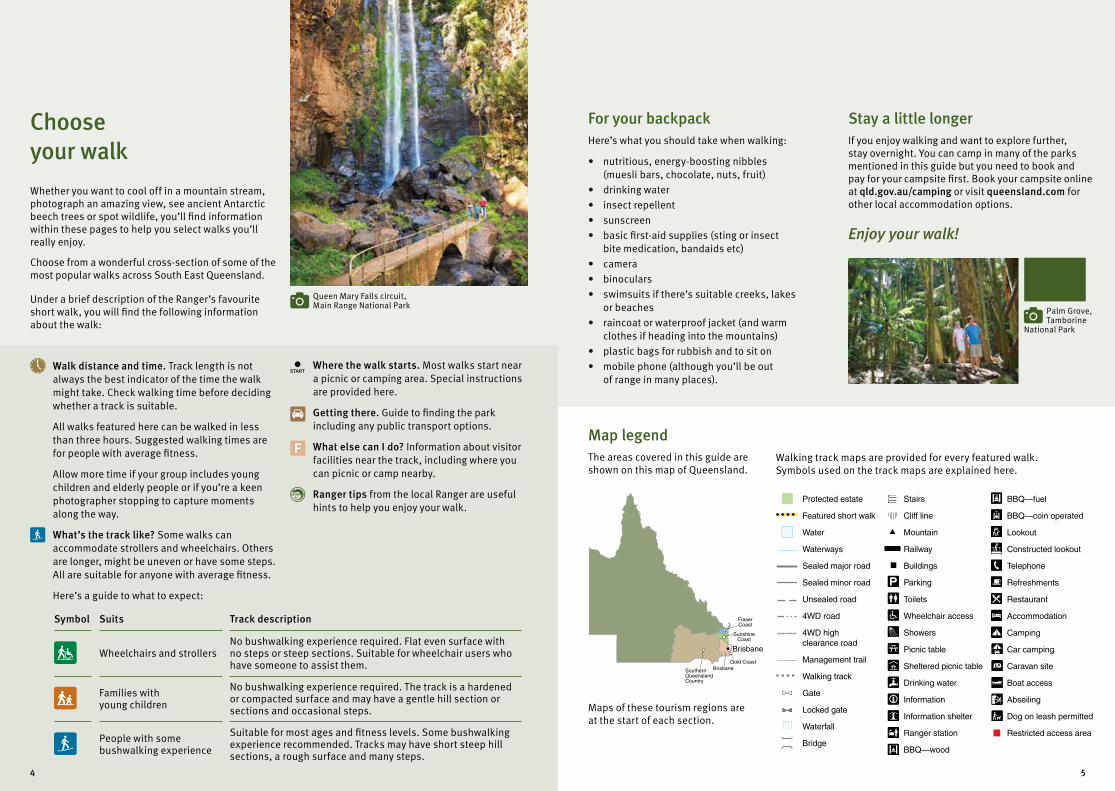
Queen Mary Falls circuit, Main Range National Park
Palm Grove, Tamborine
National Park
400 km
Brisbane
SouthernQueenslandCountry
BrisbaneGold Coast
SunshineCoast
FraserCoast
Protected estate
Featured short walk
Water
Waterways
Sealed major road
Sealed minor road
Unsealed road
4WD road
4WD high clearance road
Management trail
Walking track
Gate
Locked gate
Waterfall
Bridge
Stairs
Cliff line
Mountain
Railway
Buildings
Parking
Toilets
Wheelchair access
Showers
Picnic table
Sheltered picnic table
Drinking water
Information
Information shelter
Ranger station
BBQ—wood
BBQ—fuel
BBQ—coin operated
Lookout
Constructed lookout
Telephone
Refreshments
Restaurant
Accommodation
Camping
Car camping
Caravan site
Boat access
Abseiling
Dog on leash permitted
Restricted access area
Where the walk starts. Most walks start near a picnic or camping area. Special instructions are provided here.
Getting there. Guide to finding the park including any public transport options.
F What else can I do? Information about visitor facilities near the track, including where you can picnic or camp nearby.
Ranger tips from the local Ranger are useful hints to help you enjoy your walk.
Choose your walkWhether you want to cool off in a mountain stream, photograph an amazing view, see ancient Antarctic beech trees or spot wildlife, you’ll find information within these pages to help you select walks you’ll really enjoy.
Choose from a wonderful cross-section of some of the most popular walks across South East Queensland.
Under a brief description of the Ranger’s favourite short walk, you will find the following information about the walk:
Walk distance and time. Track length is not always the best indicator of the time the walk might take. Check walking time before deciding whether a track is suitable.
All walks featured here can be walked in less than three hours. Suggested walking times are for people with average fitness.
Allow more time if your group includes young children and elderly people or if you’re a keen photographer stopping to capture moments along the way.
What’s the track like? Some walks can accommodate strollers and wheelchairs. Others are longer, might be uneven or have some steps. All are suitable for anyone with average fitness.
Here’s a guide to what to expect:
Symbol Suits Track description
Wheelchairs and strollers No bushwalking experience required. Flat even surface with no steps or steep sections. Suitable for wheelchair users who have someone to assist them.
Families with young children
No bushwalking experience required. The track is a hardened or compacted surface and may have a gentle hill section or sections and occasional steps.
People with some bushwalking experience
Suitable for most ages and fitness levels. Some bushwalking experience recommended. Tracks may have short steep hill sections, a rough surface and many steps.
For your backpackHere’s what you should take when walking:
• nutritious, energy-boosting nibbles (muesli bars, chocolate, nuts, fruit)
• drinking water
• insect repellent
• sunscreen
• basic first-aid supplies (sting or insect bite medication, bandaids etc)
• camera
• binoculars
• swimsuits if there’s suitable creeks, lakes or beaches
• raincoat or waterproof jacket (and warm clothes if heading into the mountains)
• plastic bags for rubbish and to sit on
• mobile phone (although you’ll be out of range in many places).
Map legendThe areas covered in this guide are shown on this map of Queensland.
Maps of these tourism regions are at the start of each section.
Stay a little longerIf you enjoy walking and want to explore further, stay overnight. You can camp in many of the parks mentioned in this guide but you need to book and pay for your campsite first. Book your campsite online at qld.gov.au/camping or visit queensland.com for other local accommodation options.
Enjoy your walk!
Walking track maps are provided for every featured walk. Symbols used on the track maps are explained here.
4 5
Brisbane
Gatton
Esk
Ipswich
Manly
Cleveland
Beaudesert
Rathdowney
Redcliffe
Kilcoy
Boonah
Caboolture
Woodford
To Kingaroy
To Warwick
To Toowoomba
To Gympie
Tamborine
Canungra
Loganholme
To Killarney
LegendBrisbane tourism region
Protected estate
World Heritage area
Sealed road
Town
D’Aguilar National Park
Daisy Hill Conservation Park
Fort Lytton National Park
St Helena Island National Park
Moreton Island National Park
Naree Budjong Djara National Park
Moreton Bay
1
1
2
3
4
5
6
2
34
5
6
Minjerribah (North Stradbroke Island)
20 40kmScale0
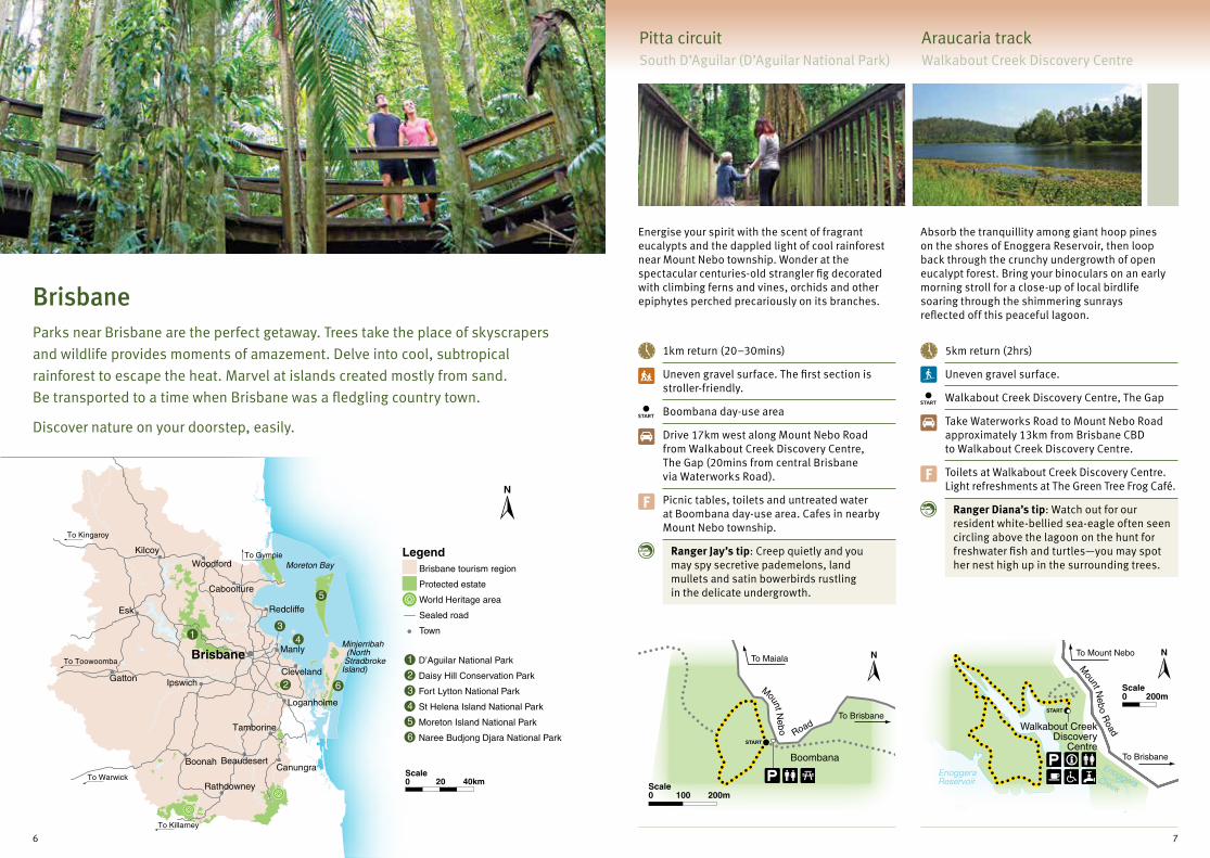
BrisbaneParks near Brisbane are the perfect getaway. Trees take the place of skyscrapers
and wildlife provides moments of amazement. Delve into cool, subtropical
rainforest to escape the heat. Marvel at islands created mostly from sand.
Be transported to a time when Brisbane was a fledgling country town.
Discover nature on your doorstep, easily.
Pitta circuitSouth D’Aguilar (D’Aguilar National Park)
Araucaria track Walkabout Creek Discovery Centre
Energise your spirit with the scent of fragrant eucalypts and the dappled light of cool rainforest near Mount Nebo township. Wonder at the spectacular centuries-old strangler fig decorated with climbing ferns and vines, orchids and other epiphytes perched precariously on its branches.
Absorb the tranquillity among giant hoop pines on the shores of Enoggera Reservoir, then loop back through the crunchy undergrowth of open eucalypt forest. Bring your binoculars on an early morning stroll for a close-up of local birdlife soaring through the shimmering sunrays reflected off this peaceful lagoon.
1km return (20–30mins)
Uneven gravel surface. The first section is stroller-friendly.
Boombana day-use area
Drive 17km west along Mount Nebo Road from Walkabout Creek Discovery Centre, The Gap (20mins from central Brisbane via Waterworks Road).
F Picnic tables, toilets and untreated water at Boombana day-use area. Cafes in nearby Mount Nebo township.
Ranger Jay’s tip: Creep quietly and you may spy secretive pademelons, land mullets and satin bowerbirds rustling in the delicate undergrowth.
5km return (2hrs)
Uneven gravel surface.
Walkabout Creek Discovery Centre, The Gap
Take Waterworks Road to Mount Nebo Road approximately 13km from Brisbane CBD to Walkabout Creek Discovery Centre.
F Toilets at Walkabout Creek Discovery Centre. Light refreshments at The Green Tree Frog Café.
Ranger Diana’s tip: Watch out for our resident white-bellied sea-eagle often seen circling above the lagoon on the hunt for freshwater fish and turtles—you may spot her nest high up in the surrounding trees.
6 7
Mount Neb
o
Road
To Brisbane
To Maiala
Boombana
START
100 200mScale0
START
Walkabout Creek Discovery
Centre
EnoggeraReservoir
To Brisbane
200mScale0
Enoggera Creek
To Mount Nebo
Mount N
ebo R
oad

Piccabeen walkNorth D’Aguilar (D’Aguilar National Park)
Paperbark trail Daisy Hill Conservation Park
Escape into a mysterious forest grove through dappled light and over pebble-lined creek beds. Flashes of crimson and green burst into the forest canopy as Australian king-parrots feast on red berries hanging like chandeliers from piccabeen palms. Let the rainforest life cleanse the city bustle from your mind.
Sharpen your senses in a storybook setting among melaleuca wetlands fed by a natural freshwater spring. Inhale the sweet summer-time blossoms of paperbarks in this isolated pocket encircled by drier eucalypt forest. Listen for frog choruses after rain and spy holes where bandicoots dig searching for worms and fungi to feast on.
1km return (20–30mins)
Assisted-wheelchair access and stroller-friendly.
The Gantry day-use area
Head west of Brisbane to Dayboro. Follow Mount Mee Road and turn onto Sellin Road, travelling 5km to The Gantry day-use area.
F Toilets, wood and electric barbecues, untreated water and picnic tables at The Gantry day-use area. Camp nearby at Neurum Creek and Archer camping areas.
Ranger Scott’s tip: See if you can spot a tiny green ground orchid Acianthus amplexicaulis growing in the perfect mulch of leaves and bark dropped by Sydney blue gums. This is one of only a few sites in South East Queensland where it is found.
450m return (15mins)
Wheelchair-accessible and stroller-friendly.
Daisy Hill picnic area
Take the Pacific Motorway between Brisbane and the Gold Coast and turn off at Exit 24. Follow the signs and drive 2.5km to the end of Daisy Hill Road.
F Toilets, wood barbecues and picnic tables in lower and upper day-use areas.
Ranger Pete’s tip: Don’t be alarmed by the orange oily sheen on the creek surface—it’s not pollution but the by-product of a harmless natural bacteria!
Fort walkFort Lytton National Park
Island walk St Helena Island National Park
Step back in time to Queensland’s colonial past and discover the Anzac spirit at Fort Lytton. Amble around the fort at your own pace or have fun on a guided tour. With rolling green hills and views to the bay, you’ll find it hard to believe you’re in the middle of a vibrant city. Imagine the buzz when this was Brisbane’s frontline for defence.
Relive Queensland’s colonial past among prison ruins, wandering the same roads taken by prisoners more than 100 years ago. History is so much more interesting outside books and classrooms—discover stories of prisoners, warders and their families in the 19th century.
About 1km return (90mins)
Grass pathways unsuited to wheelchairs and strollers.
Fort Lytton Visitor Information Centre
Travel east along Lytton Road or the Port of Brisbane Motorway taking the Lytton exit. Follow signs to the park.
F Wheelchair-accessible toilets. Picnic area beside the river. Light refreshments. Open Sundays and public holidays. Phone (07) 3393 4647 for weekday group bookings.
Ranger Roly’s tips: Experience a great combination of history and mystery by booking a night tour—it’s my favourite time to visit. Check out the museum display by day.
5km return (3hrs). Guided tours only.
Crushed coral roads and grassy pathways with no steps. Unsuitable for wheelchairs and strollers.
Causeway where boats offload visitors
45mins by boat from Manly, Brisbane. Regular tour boat services from Manly and Hamilton. Check the white pages for details.
F Wheelchair-accessible toilets. Picnic area by foreshore. BYO barbecue. Pre-book your guided tour. Fees apply.
Ranger Roly’s tips: St Helena, one of Queensland’s best heritage sites, is well worth the visit. If you’ve got your own boat, you’re welcome to access the southern beach area for free.
8 9
START
250 500mScale0
The Gantry
Sellin
Road
To parkentrance
Daisy Hill picnic area
START
100 200mScale0
Fort Lytton
Museum
Visitor information centre
START
50 100mScale0
Brisbane River
Prison stockade
Sugar mill
Prisoners’ cemetery
Jetty
Causeway
START
Museum
300 600mScale0

Five Hills lookoutMoreton Island National Park
Kaboora track Naree Budjong Djara National Park
Invigorate your mind and body as you climb the dunes through pristine coastal heath bursting with banksia pods, dwarf casuarinas and grass trees. Soak up golden sunshine atop the sand dunes and be rewarded with views over the island to Cape Moreton lighthouse, and Heath Island, where the land meets the sea.
Connect with the spiritual nature of Blue Lake, called ‘Kaboora’ by the Quandamooka people. Twisted branches of dwarf eucalypt trees, wallum banksias and grasstrees welcome your arrival at this living ark. Soak up the sights and sounds of this unchanged wildlife haven, home to sand goannas and the golden wallaby—a form of swamp wallaby found only on Moreton Bay islands.
1km return (30mins)
Sandy surface.
Bulwer–North Point Road
Travel along Bulwer–North Point Road 3.5km from North Point.
F Toilets, showers and a camping area at North Point.
Ranger Leanne’s tips: With a good camera lens or binoculars you’ll spy migratory and resident shorebirds darting along the beach. See if you can identify ospreys, white-faced herons, beach stone-curlews and eastern curlews.
6km return (1.5–2hrs)
Sandy surface.
Blue Lake carpark on Alfred Martin Way
Travel 7.8km along Alfred Martin Way from Dunwich.
F Public toilets at Dunwich.
Ranger Dan’s tip: Blue Lake is sacred to the local Quandamooka people, the Traditional Owners of Minjerribah (North Stradbroke Island). Please respect the cultural signifi cance of this site by not swimming in the lake.
10
Five Hills
Bulwer–North Point R
oad
To North Point
500m250Scale0
START
Blue Lake
AlfredMartin Way
To Dunwich
START
0.5 1kmScale0
Pacific M
wy
Coolangatta
Surfers Paradise
SouthportNerang
Burleigh Head
BinnaBurraGreen Mountains
Mount Cougal
Beechmont
Springbrookplateau
Natural Bridge
Mudgeeraba
Beenleigh
Canungra
NorthTamborine
TamborineOxenford
To Brisbane
To Beaudesert
LegendGold Coast tourism region
Protected estate
World Heritage area
Sealed road
Town
Lamington National Park
Springbrook National Park
Tamborine National Park
Burleigh Head National Park
David Fleay Wildlife Park
Gold Coast Highway
Moreton Bay
SouthStradbroke Island
1
2
3
4
5
1
2
3
45
8 16kmScale0
Gold CoastVenture beyond the beaches into a cool, green world in the Gold Coast hinterland.
Feel revitalised by enchanting sights and sounds of the ancient Gondwana Rainforests
of Australia World Heritage Area, a precious haven for wildlife. Enjoy bird’s-eye views
across rippling plateaus and valleys to glittering golden beaches on the horizon.
Have a close encounter with rainforest giants, plunging waterfalls and amazing wildlife.
Escape and feel revitalised, naturally.
11

KweebaniCave
Binna Burra upper day-use area
Rifle
Bird
Cre
ek
START
Binn
a B
urra Road
250mScale0
Tullawallal
Binna Burra upper day-use area
Rifl
e Bird
Creek
Bellb
ird
Creek
START
0.5 1kmScale0
Morans Falls
O’Reilly’sRainforest Retreat
Lamington National Park Road
START
PythonRock lookout
Morans Fallslookouts
500mScale0
Morans Falls
O’Reilly’sRainforest Retreat
START
Lamington National Park RoadPython
Rock lookout
Morans Fallslookouts
500mScale0
Rainforest circuitBinna Burra (Lamington National Park)
Tullawallal circuit Binna Burra (Lamington National Park)
Meander through lush, mist-shrouded groves of warm, subtropical rainforest. Towards evening, enjoy the magical atmosphere among ancient forest giants as the sun slips behind the mountains and songbirds call in the twilight.
Enter an enchanted world. Like a scene from ‘Lord of the Rings’, gnarled giant trees hold dripping wispy lichens among deep mysterious tree hollows and moss-drenched boulders. Take the short side track to walk amid Antarctic beech trees—relics of the prehistoric forest of Gondwana.
1.2km return (30mins)
Uneven gravel surface. Slippery when wet.
Binna Burra upper day-use area
Turn off the Pacific Highway at Nerang and follow the signposts 36km to Binna Burra via Beechmont and Binna Burra roads. Access unsuitable for caravans.
F Toilets, picnic tables, untreated water and electric barbecues at Binna Burra upper day-use area. Private camping nearby.
Ranger Greg’s tip: Pick up a self-guided brochure from the information centre to discover more along this magical walk.
5km return (1.5hrs)
Exposed roots and uneven surface.
Binna Burra upper day-use area
Turn off the Pacific Highway at Nerang and follow the signposts 36km to Binna Burra via Beechmont and Binna Burra roads. Access unsuitable for caravans.
F Toilets, picnic tables, untreated water and electric barbecues at Binna Burra upper day-use area.
Ranger Wil’s tip: Stop and wait—can you hear a scuffling noise in the understorey? This forest is alive with birds; it might be a logrunner frantically scratching the leaf litter looking for an insect meal.
Python Rock trackGreen Mountains (Lamington National Park)
Morans Falls track Green Mountains (Lamington National Park)
Behold a world of giants! Enormous curved buttress roots rise from the ground as booyong and fig trees tower overhead. Inhale sweet flowering grasstree spikes as you pass into open woodland near Python Rock lookout and gaze at spectacular views of Morans Falls, Castle Crag and towards Mt Razorback.
Ramble down through rainforest adorned with twisted vines and bird’s nest ferns to a lookout with spectacular views of Morans Falls tumbling dramatically 80m into the valley below. Keep to the track over a crystal-clear creek and let it lead you to sweeping views over the Albert River valley, Mt Lindesay and Mt Barney.
4.9km return (1.5hrs)
Even gravel surface. Assisted-wheelchair access and stroller-friendly.
Lamington National Park Road, 150m downhill from the park information centre
Drive 31.5km from Canungra along Lamington National Park Road. Unsuitable for recreational vehicles longer than 4m and vehicles towing caravans or camper trailers.
F Limited parking at track entrance. Toilets, picnic tables, electric barbecues, untreated water and information centre at Green Mountains day-use area. Kiosk nearby.
Ranger Kevin’s tip: Shh! During the winter months, if you walk quietly, you might hear the delightful ringing calls and mimicry of the elusive Albert’s lyrebird.
6.2km return (2hrs)
Uneven gravel surface with some steps.
Lamington National Park Road, 150m downhill from the park information centre
Drive 31.5km from Canungra along Lamington National Park Road. Unsuitable for recreational vehicles longer than 4m and vehicles towing caravans or camper trailers.
F Limited parking at track entrance. Toilets, picnic tables, electric barbecues, untreated water and information centre at Green Mountains day-use area. Kiosk nearby.
Ranger Kim’s tip: Look for soft pink sprays of stream lilies daring to cling to the cliff face just beside the falls.
12 13
Cave Creek
Nerang–M
urwillum
bah Road
START
To Nerang
To Murwillumbah
Bakers Road 500mScale0
Currumbin Creek
Remains of bush sawmill
Cougal Cascades carpark and picnic area
Currumbin Cre
ek R
oadTo Currumbin
START
250 500mScale0
To Springbrook plateau
START
Best of Alllookout
Repeater Statio
n Roa
d
250mScale0
Gwongorellapicnic area
TanninabaFalls
Purling Brook Falls
Warringa Pool
Springbrook Road
Fore
stry
Roa
d
START
250 500mScale0
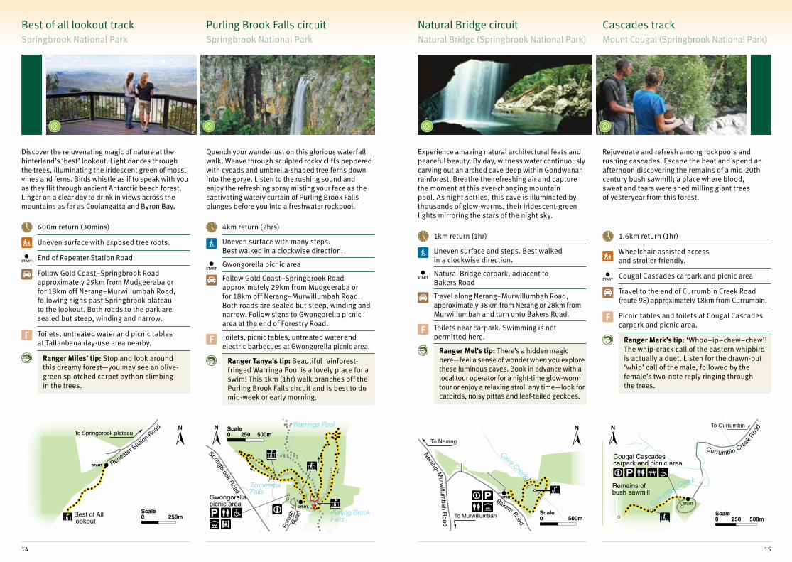
Natural Bridge circuitNatural Bridge (Springbrook National Park)
Cascades track Mount Cougal (Springbrook National Park)
Experience amazing natural architectural feats and peaceful beauty. By day, witness water continuously carving out an arched cave deep within Gondwanan rainforest. Breathe the refreshing air and capture the moment at this ever-changing mountain pool. As night settles, this cave is illuminated by thousands of glow-worms, their iridescent-green lights mirroring the stars of the night sky.
Rejuvenate and refresh among rockpools and rushing cascades. Escape the heat and spend an afternoon discovering the remains of a mid-20th century bush sawmill; a place where blood, sweat and tears were shed milling giant trees of yesteryear from this forest.
1km return (1hr)
Uneven surface and steps. Best walked in a clockwise direction.
Natural Bridge carpark, adjacent to Bakers Road
Travel along Nerang–Murwillumbah Road, approximately 38km from Nerang or 28km from Murwillumbah and turn onto Bakers Road.
F Toilets near carpark. Swimming is not permitted here.
Ranger Mel’s tip: There’s a hidden magic here—feel a sense of wonder when you explore these luminous caves. Book in advance with a local tour operator for a night-time glow-worm tour or enjoy a relaxing stroll any time—look for catbirds, noisy pittas and leaf-tailed geckoes.
1.6km return (1hr)
Wheelchair-assisted access and stroller-friendly.
Cougal Cascades carpark and picnic area
Travel to the end of Currumbin Creek Road (route 98) approximately 18km from Currumbin.
F Picnic tables and toilets at Cougal Cascades carpark and picnic area.
Ranger Mark’s tip: ‘Whoo–ip–chew–chew’! The whip-crack call of the eastern whipbird is actually a duet. Listen for the drawn-out ‘whip’ call of the male, followed by the female’s two-note reply ringing through the trees.
Best of all lookout trackSpringbrook National Park
Purling Brook Falls circuit Springbrook National Park
Discover the rejuvenating magic of nature at the hinterland’s ‘best’ lookout. Light dances through the trees, illuminating the iridescent green of moss, vines and ferns. Birds whistle as if to speak with you as they flit through ancient Antarctic beech forest. Linger on a clear day to drink in views across the mountains as far as Coolangatta and Byron Bay.
Quench your wanderlust on this glorious waterfall walk. Weave through sculpted rocky cliffs peppered with cycads and umbrella-shaped tree ferns down into the gorge. Listen to the rushing sound and enjoy the refreshing spray misting your face as the captivating watery curtain of Purling Brook Falls plunges before you into a freshwater rockpool.
600m return (30mins)
Uneven surface with exposed tree roots.
End of Repeater Station Road
Follow Gold Coast–Springbrook Road approximately 29km from Mudgeeraba or for 18km off Nerang–Murwillumbah Road, following signs past Springbrook plateau to the lookout. Both roads to the park are sealed but steep, winding and narrow.
F Toilets, untreated water and picnic tables at Tallanbana day-use area nearby.
Ranger Miles’ tip: Stop and look around this dreamy forest—you may see an olive-green splotched carpet python climbing in the trees.
4km return (2hrs)
Uneven surface with many steps. Best walked in a clockwise direction.
Gwongorella picnic area
Follow Gold Coast–Springbrook Road approximately 29km from Mudgeeraba or for 18km off Nerang–Murwillumbah Road. Both roads are sealed but steep, winding and narrow. Follow signs to Gwongorella picnic area at the end of Forestry Road.
F Toilets, picnic tables, untreated water and electric barbecues at Gwongorella picnic area.
Ranger Tanya’s tip: Beautiful rainforest-fringed Warringa Pool is a lovely place for a swim! This 1km (1hr) walk branches off the Purling Brook Falls circuit and is best to do mid-week or early morning.
14 15

EchoBeach
SouthPacific Ocean
The Cove
Tumgun lookout
Goodwin Tce
George St
START
START
Gol
d C
oast
Hig
hw
ay
200 400mScale0
Fleays Wildlife Park Road
Creek R
d
Wes
t Bur
leig
h R
oad
Park entrySTART
Tallebudgera Creek
100mScale0
Geiss
mann Drive
Eagle H
eigh
ts Road
Ced ar Creek
Dap
san g
Ave
START
200mScale0
Sandy Creek
Knoll R
oad
Cameron Falls
START
The Knoll day-use area
100 200mScale0
Oceanview trackBurleigh Head National Park
Wildlife boardwalk David Fleay Wildlife Park
Explore a forest oasis in the heart of the Gold Coast, with the sparkling Pacific Ocean as a most dramatic backdrop. Tumbled volcanic rocks on the rocky shore create an adventurous place to recharge and reconnect with nature, and the family can truly relax at Echo Beach near the mouth of Tallebudgera Creek.
Have fun at this park with a difference. Animals roam free around your boardwalk in wetland, open forest and rainforest. Applaud the graceful dance of brolgas. Meet the resident platypus Wally. Catch a glimpse of a tree-kangaroo resting in a tree fork or cassowaries busily spreading seeds in the rainforest.
1.5km (1.5–2hrs)
Wheelchair-accessible and stroller-friendly.
Inside the park near the kiosk
Corner of Loman and West Burleigh roads, West Burleigh. Take exit 89 off the Pacific Motorway.
F Toilets and kiosk at the centre. Entry fees apply.
Ranger Steve’s tip: This place will open your eyes to the beauty and diversity of local wildlife. Don’t miss a talk or activity with a ranger—our enthusiasm is contagious.
2.4km return (45mins)
Sealed track. Stroller-friendly. Track closed before and after extreme weather for safety.
Goodwin Terrace, Burleigh Heads or Gold Coast Highway just north of Tallebudgera Creek
Take exit 89 off the Pacific Highway and head to Burleigh Heads on the Gold Coast Highway or turn off at the traffic lights just past Tallebudgera Creek on the Gold Coast Highway.
F Council picnic area and toilets (northern entrance) and toilets near southern entrance in the carpark.
Ranger Henry’s tip: Go on, complete the circuit—you won’t regret it. See passing whales and dolphins in winter or stunning Richmond birdwing butterflies in summer.
Curtis Falls trackJoalah (Tamborine National Park)
Sandy Creek circuit The Knoll (Tamborine National Park)
Feel the cool air shiver across your skin as you venture through eucalypt forest beneath towering flooded gums and into lush shaded rainforest. Stop to admire beautiful bird’s nest and staghorn ferns high in the canopy. Enjoy views of the falls from the lookout and keep an eye out for platypus splashing in the creek.
Venture inside the hollowed-out bases of pale majestic flooded gums—old giants have watched over this forest for thousands of years. Admire breathtaking views across the valley to the edge of Brisbane on a scenic meander through lush rainforest and eucalypt woodland. Cool your feet in the icy water of Sandy Creek then venture to the lookout to watch the white spray of Cameron Falls plummet over the cliff top.
1.1km return (30mins)
Uneven surface and steps. Slippery when wet.
Joalah section, Tamborine National Park, off Dapsang Avenue and Eagle Heights Road
Travel via Oxenford–Tamborine Road, Tamborine Mountain Road or Main Western Road and follow signs to Tamborine National Park—Joalah section.
F Toilets at Joalah day-use area. Cafes nearby.
Ranger John’s tip: This is a great place to learn some of nature’s ‘calling cards’—for example, scratchings in the dirt in winter are signs of the Albert’s lyrebird searching for ants to devour.
2.6km return (1hr)
Uneven surface.
The Knoll, Tamborine National Park, off Knoll Road
Travel via Oxenford–Tamborine Road, Tamborine Mountain Road or Main Western Road and follow signs to The Knoll, Tamborine National Park.
F Toilets, picnic tables and gas barbecues at The Knoll day-use area.
Ranger Murray’s tip: See a flash of iridescent blue? It might be a spiny crayfish, scuttling out of the way as you crisscross Sandy Creek.
16 17

Cliff lookout
Queen Mary Falls lookout
Queen Mary Falls
Privatecamping area
To Boonah
Spring Creek
To WarwickSTART
200mScale0
Gre
at Dividing Range
250 500mScale0
START
To Goomburra and Allora
Roma
Texas
Dalby
Wallangarra
St George
Miles
Stanthorpe
Wondai
Injune
Nanango
Crows Nest
Millmerran
Warwick
Mitchell
Chinchilla
Mungindi
Surat
Wandoan
Kingaroy
Toowoomba
Inglewood
Blackbutt
Gatton
To Rolleston
To Mundubbera
To Gayndah
To Taroom
To Lightning Ridge
To BoonahTo Ipswich
To Killarney
To Charleville
To Cunnamulla
To MoreeTo Tenterfield
Goondiwindi
LegendSouthern Queensland Country tourism region
Protected estate
World Heritage area
Sealed road
Town
Main Range National Park
Girraween National Park
Sundown National Park
Ravensbourne National Park
Crows Nest National Park
The Palms National Park
Bunya Mountains National Park
1
23
45
67
60 120kmScale0
1
2
3
4
5
6
7
Southern Queensland CountryFollow ever-changing scenic country roads to the heart of Southern Queensland, where unexpected natural gems will awaken your senses. Embrace the details of country life—crunch fallen leaves and sometimes frost under your feet, wonder at ancient forests and exquisite wildflowers, admire scenic vistas and balancing granite boulders, or linger at a cool rockpool.
Relax in an ever-changing landscape, naturally.
Queen Mary Falls circuitMain Range National Park
Sylvesters lookout Main Range National Park
Delight in the cool spray and refreshing scent of Spring Creek which plunges 40m over Queen Mary Falls. Get your camera snapping from the bridge beneath or lookout above, and spy ever-watchful eastern water dragons waiting to snap up a tasty meal.
Energise your body and mind in lush subtropical rainforest, where amazing displays of ferns and orchids cling to the trees towering over the track. Enjoy the rewarding views from the Main Range escarpment across the Fassifern Valley to rugged peaks of the Scenic Rim.
2km return (40mins)
Steep stairs, cliff edges and sometimes slippery track surface. Supervise children closely. Track closed after heavy rain.
Queen Mary Falls day-use area
11km east of Killarney via Spring Creek Road.
F Toilets in day-use area. Food and accommodation at caravan park nearby.
Ranger Steve’s tip: Avoid climbing stairs.Walk in a clockwise direction to the base of the falls then return by the gradually sloping track. Or simply stroll the shorter Cliff circuit (570m return) to the top of the falls.
940m return (30mins)
Uneven surface with some muddy sections.
Lookout Road, 4.7km drive from Goomburra’s Kurrajong picnic area
Turn off the Cunningham Highway 25km west of Cunningham’s Gap; or off the New England Highway 3km south of Allora. Head east through Goomburra Valley along a winding road with gravel sections and creek crossings. The steep Lookout Road is closed in wet weather.
F No facilities. Camp nearby at Goomburra.
Ranger Andy’s tip: This place is beautiful year-round, and bursts into extravagant colour at springtime, when stunning red flowers of giant spear lilies reach out on long stalks from the cliff edge.
18 19

Information centre
Bald Rock Creek day-use area
Granite Arch
Bald Rock Creek
BaldRock Creekcamping area
500mScale0
START
Dr Roberts Waterhole
UndergroundCreek
Bald Rock CreekTo Girraween information centre
1km0.5Scale0
START
Red Rock Gorge camping area
Red Rock Creek
START
150mScale0
To Ballandean
100 200 300 400 mScale0
PalmCree
k
Gus Beutel lookout
To Toowoomba
Sandstone overhang
17 Mile
Road
START
Blackbeanday-use area
Cedar Blockday-use area
200mScale0
Granite ArchGirraween National Park
Underground Creek Girraween National Park
Take delight in the details—an amazing rock sculpture, a delicate wildflower, some feathered, furred or scaly creature or a postcard scene. Snap a selfie under the magnificent natural stone archway, or beside Bald Rock Creek’s tumbling cascades and cool, refreshing rockpools.
Be mesmerised by burnished-gold water-sculpted rocks and the swirling eddies of Bald Rock Creek as it disappears mysteriously underground. Delight in colourful wildflowers and the varied birdlife of the woodlands, heathlands and shrublands encountered along the way.
1.6km return (30mins)
Uneven surface, rocky pavements and some steps.
Bald Rock Creek day-use area
Toilets and picnic area near track entrance. Camping areas nearby.
F 9km east of the New England Highway. Turn off 26km south of Stanthorpe or 30km north of Wallangarra.
Ranger Jo’s tips: Release your inner birdwatcher! There’s more than 100 species flitting around this park, and the kids will love climbing rocks and exploring along the creek. If there’s time, add Bald Rock Creek circuit to your visit (2.2km, 1hr return).
2.8km return (1-1.5hrs)
Uneven surface with inclines and open rocky pavement areas. Rock-hopping at the end of the track.
Carpark 4km east of Bald Rock Creek day-use area
13km east of the New England Highway. Turn off 26km south of Stanthorpe or 30km north of Wallangarra. The last 4km is unsealed.
F No facilities. Toilets in day-use area 4km away. Camping also 4km away.
Ranger Neal’s tip: Keen for more? Enjoy an easy 1.2km (30mins return) side-trip to contemplate nature reflected in the still deep waters of nearby Dr Roberts waterhole.
Palm Creek circuit Ravensbourne National Park
Linger in cool, shaded rainforest where dangling palm fronds almost embrace you as you descend into Palm Creek. Venture into open forest across the creek where you’ll see more wildlife—small birds and reptiles keep warm in patches of bright sunlight.
3.6km return (1hr 15mins)
Some steep steps and potentially muddy surfaces.
Blackbean day-use area
Turn off the New England Highway at Hampton (32km north of Toowoomba) and head east for 17km to the park turn-off. From Esk, follow the Esk-Hampton Road for 33km before turning off to the park. Drive another 1.3km to Blackbean day-use area.
F Pit toilets in picnic area at start of track.
Ranger Charlie’s tips: Those palm fruits make a tasty treat for white-headed and topknot pigeons in summer! If you want more rainforest, add the 930m loop of the Rainforest circuit to your return walk.
Red Rock Gorge lookoutSundown National Park
Enjoy the wild isolation of rugged wilderness ranges from a cliff edge where pink, lichen-stained granite reflects changing hues of the shifting sun. Be thrilled watching peregrine falcons dive onto unsuspecting prey. In winter, mimicking lyrebirds call from the moisture-loving vine scrubs in the gorge.
500m return (15mins)
Some steps and potentially uneven, slippery surfaces.
Red Rock Gorge camping area (only accessible in high-clearance 4WD)
Turn west off the New England Highway at Ballandean and take Curr Road then unsealed Sundown Road to the park boundary. From there it’s a further 7km (40 mins) drive along a rough 4WD track.
F Pit toilets in small camping area at start of track.
Ranger Ian’s tip: No four-wheel-drive? No worries—you can still walk in Sundown. Visit the southern end of the park and walk to stunning waterholes along the Severn River.
20 21
The CascadesKauyoo Pool
Crows Nest Falls
Picnic area Camping area
Bottlebrush Pool
100 200mScale0
START
To Cooyar
Boldery Park
50 100mScale0
START
Pine Gorgelookout
Tim SheaFalls Sa
ddle-tree Cree
k
Festoon Falls
Bunya
Ave
nue
To Dalby or Nanango
Bunya Mountains Road
Dandabah
0.5 1kmScale0
START
Mt Kiangarow1135m
To Kingaroy
Bun
ya M
ount
ains
Ro
ad
Burtons Well500mScale0
START
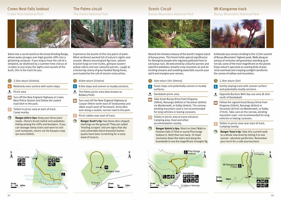
The Palms circuitThe Palms National Park
Experience the bustle of this tiny patch of palm-filled rainforest packed full of nature’s sights and sounds. Weave around giant fig trees, admire bracket fungi on tree trunks, glimpse eastern yellow robins and see colourful parrots. Laugh at a bickering colony of grey-headed flying-foxes, punctuated by the call of elusive noisy pittas.
650m return (15mins)
A few steps and uneven or muddy sections.
The Palms picnic area (also known as Boldery Park)
Turn east off the New England Highway at Cooyar (94km north-east of Toowoomba and 28km south-west of Yarraman). Drive 8km east along a sealed, narrow road to the park.
F Picnic tables near start of track.
Ranger Scott’s tip: See those disc-shaped markings on the ground? They are called ‘feeding scrapes’ and are signs that shy and vulnerable black-breasted button-quails have been scratching for a tasty meal of insects.
Crows Nest Falls lookout Crows Nest National Park
Delve into a secret world on the Great Dividing Range, where water plunges over high granite cliffs into a glistening rockpool. If you long to hear the call of a whipbird, be deafened by a summer-time chorus of cicadas or just enjoy the sights and sounds of the bush, this is the track for you.
2.1km return (45mins)
Relatively even surface with some steps.
Picnic area
Turn off the New England Highway at Crows Nest Police Station and follow the sealed road 6km to the park.
F Toilets in picnic area at start of track. Camp nearby.
Ranger John’s tips: Keep your binoculars ready—there’s brush-tailed rock-wallabies hiding among the cliffs and boulders. If you can manage steep stairs and want to visit cool rockpools, return via the Kauyoo Loop (an extra 600m).
Scenic CircuitBunya Mountains National Park
Mt Kiangarow trackBunya Mountains National Park
Absorb the timeless beauty of the world’s largest stand of bunya pines. This forest holds special significance for Aboriginal people who regularly gathered here to eat bunya nuts. Be welcomed by colourful parrots and watchful wallabies; breathe crisp mountain air and let trickling streams and tumbling waterfalls nourish your spirit and energise your senses.
Exhilarate your senses strolling to the 1135m summit of Bunya Mountains’ highest peak. Walk along an avenue of centuries-old grasstrees standing up to 5m tall, some of the most magnificent on the planet. Enjoy nature’s spectacle as soaring birds of prey circle overhead and creeping sunlight transforms the canvas of valleys and mountains.
4km return (1hr 20mins)
Some steps and potentially uneven or muddy surfaces.
Dandabah picnic area
Take Great Bunya Drive from Kingaroy (59km), Nanango (60km) or Yarraman (60km) via Maidenwell, or Dalby (64km). The narrow, winding mountain road is not recommended for long vehicles or towing caravans.
F Toilets in picnic area at track entrance. Camping area, food and other accommodation nearby.
Ranger Kelvin’s tips: Short on time? Walk to Festoon Falls (770m) or sunny Pine Gorge lookout (1.3km) then turn back. Or head clockwise down the stairs and along the boardwalk to see the magnificent strangler fig.
2.3km return (1hr)
Gently sloping track with uneven surface and potentially muddy sections.
Opposite Burtons Well day-use area (8.5km north of Dandabah)
Follow the signed Great Bunya Drive from Kingaroy (50km), Nanango (65km) or Yarraman (67km) via Maidenwell, or Dalby (71km). Take care on the narrow, winding mountain road—not recommended for long vehicles or towing caravans.
F Toilets in picnic area near start of track. Camping nearby.
Ranger Tony’s tip: Take this summit walk to a whole new level by timing it to see sunset—absolute perfection. Remember your torch for a safe journey back.
22 23
Peregrine lookout
Mapleton Falls
Pencil Creek
To Mapleton
START
200m100Scale0
Caloundra
Gympie
Noosa
Coolum
Beerwah
Tewantin
DoubleIsland Point
Lake Cootharaba
Elanda Point
Bribie Island(north end)
Nambour
Montville
Goomeri
Cooroy
Kybong
Tin CanBay
Rainbow Beach
Maroochydore
To Brisbane
To GayndahToMaryborough
To Murgon
To Kilcoy
To Nanago
LegendSunshine Coast tourism region
Protected estate
Sealed road
Town
Mapleton Falls National Park
Kondalilla National Park
Dularcha National Park
Glass House Mountains National Park
Currimundi Lake Regional Park
Noosa National Park
Woondum National Park
Tewantin National Park
Conondale National Park
Brooyar State Forest
Great Sandy National Park, Cooloola Recreation Area
20 40kmScale0
1
2
3
4
5
6
7
8
9
10
11
1
23
4
5
6
7
8
9
10
11
START
Kondalilla Falls
Picnic Creek Falls
Kondalilla Falls lookoutSkene Creek
Picnic Creek
250mScale0
Sunshine CoastRevitalise yourself in vibrant and unique environments. From rainforest walks
to beachside strolls and bushland circuits, the Sunshine Coast parks and forests
welcome walkers to soak up the best of unspoilt nature. Picturesque waterfalls
and creeks, panoramic views, wildflower heaths and coastal scenery will delight.
Explore and refresh, naturally.
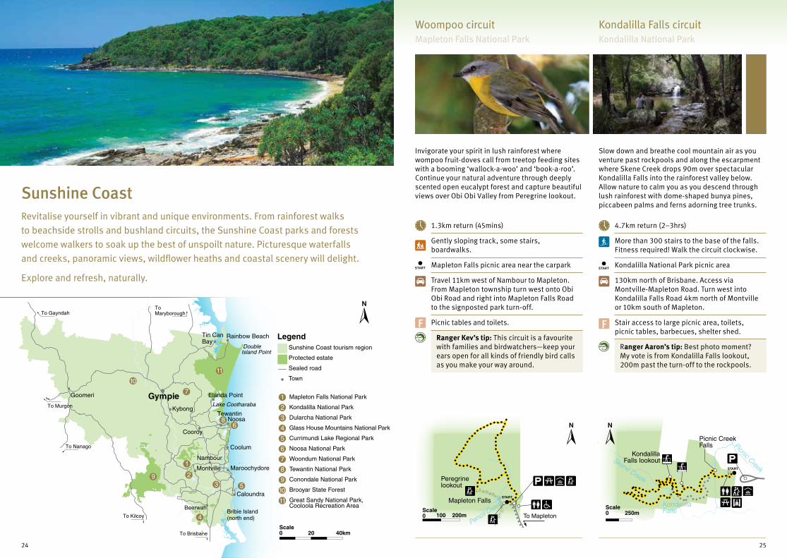
Woompoo circuitMapleton Falls National Park
Kondalilla Falls circuit Kondalilla National Park
Invigorate your spirit in lush rainforest where wompoo fruit-doves call from treetop feeding sites with a booming ‘wallock-a-woo’ and ‘book-a-roo’. Continue your natural adventure through deeply scented open eucalypt forest and capture beautiful views over Obi Obi Valley from Peregrine lookout.
Slow down and breathe cool mountain air as you venture past rockpools and along the escarpment where Skene Creek drops 90m over spectacular Kondalilla Falls into the rainforest valley below. Allow nature to calm you as you descend through lush rainforest with dome-shaped bunya pines, piccabeen palms and ferns adorning tree trunks.
1.3km return (45mins)
Gently sloping track, some stairs, boardwalks.
Mapleton Falls picnic area near the carpark
Travel 11km west of Nambour to Mapleton. From Mapleton township turn west onto Obi Obi Road and right into Mapleton Falls Road to the signposted park turn-off.
F Picnic tables and toilets.
Ranger Kev’s tip: This circuit is a favourite with families and birdwatchers—keep your ears open for all kinds of friendly bird calls as you make your way around.
4.7km return (2–3hrs)
More than 300 stairs to the base of the falls. Fitness required! Walk the circuit clockwise.
Kondalilla National Park picnic area
130km north of Brisbane. Access via Montville-Mapleton Road. Turn west into Kondalilla Falls Road 4km north of Montville or 10km south of Mapleton.
F Stair access to large picnic area, toilets, picnic tables, barbecues, shelter shed.
Ranger Aaron’s tip: Best photo moment? My vote is from Kondalilla Falls lookout, 200m past the turn-off to the rockpools.
24 25

Lake BaroonBaroon Pocket Dam
Narrows Road
Picnic areaSTART
Baroonlookout
Narrowslookout
500mScale0
Jones Street
Landsborough-M
aleny Road
Bray Road
Roses Road
Dorson Drive
Beech Road
Kin g Road
Tunnel
North Coast Railway
START
START
Moo
lool
ah
River
To Landsborough railway station
To Mooloolah railway station
Paget Street (Note: this street is not continuous but separated by pathway)
1km0.5Scale0
CurrimundiLake
Bareki S
treet
CoongarraEsplanade
START
200 400mScale0
START
Marshes RoadB
arrs
Roa
d
Mount Tibrogargan
1km0.5Scale0
Tunnel track Dularcha National Park
Harmonise with nature deep in the Blackall Range. Explore valleys filled with palms and vine forest and forested ridges dissected by streams. Meander through rainforested gullies before a steady climb to Baroon lookout. Revel in the awe-inspiring views over Obi Obi Gorge far below.
Indulge your imagination in a historic rail adventure! Follow a narrow gauge steam train rail line that ran between Brisbane and Gympie more than 100 years ago. Wander through open eucalypt forest and pockets of rainforest before entering the disused historic railway tunnel. Walk quietly to avoid disturbing the large-footed myotis bats sometimes roosting here.
4km return (2hrs)
Steep in parts, can be muddy after rain, multiple boardwalks.
Sunshine Coast Hinterland Great Walk entrance, Baroon Pocket carpark
90km north of Brisbane. From Montville follow signs to Baroon Pocket Dam via Western Avenue and Narrows Road. Turn right into Great Walks carpark just before the dam.
F Picnic area with toilets, tables and wood barbecues at Baroon Pocket Dam nearby.
Ranger Mark’s tips: Stay on the boardwalk from Narrows lookout to help protect the rare ‘hip-pocket frog’, a very special local. Don’t miss the short detours to Narrows lookout and Obi Obi Creek.
6km return (2hrs)
This track is shared with mountain bike riders and horseriders.
Off Beech Road, Landsborough or Dorson Drive, Mooloolah
90km north of Brisbane. Take the Glass House Mountains tourist drive (Exit 24) turn-off onto Steve Irwin Way to Landsborough.
F Toilets and picnic facilities in Landsborough and Mooloolah.
Ranger Cheryl’s tip: It’s all in the detail! Take a torch and you’ll discover a fascinating world with colourful moths, spiders, delicate moisture-loving ferns, and a colony of insect-eating microbats.
Narrows & Baroon lookouts Kondalilla National Park
Tibrogargan circuitGlass House Mountains National Park
Beach Access track Currimundi Lake Conservation Park
Relax in the beauty of this significant Indigenous cultural landscape. Lieutenant Cook named the ‘Glass House Mountains’ while sailing past in 1770. Mountain View lookout offers a glimpse of some volcanic peaks. Skirt around the base of Mount Tibrogargan lingering in the casuarina groves and open forests as the imposing, craggy peak towers above you.
Reconnect with nature as chattering birdlife and busy insects keep you company on a journey through wallum heath, sand dunes and onto the beach. Enjoy the cool shade of rainforest plants forming a low, dense canopy overhead, before sunshine washes over you on the foredunes. Embrace the sense of space and scenic views south to Caloundra and south-east to Moreton Island.
3.2km return (1.5hrs)
Gently sloping track with places to sit and take in the views.
Northern end of Mount Tibrogargan carpark
About 70km north of Brisbane via the Bruce Highway. Take the Glass House Mountains tourist drive (exit 24) and follow the signs to the park off Barrs Road.
F Toilets and picnic table at Mount Tibrogargan day-use area. Glass House Mountains Visitor and Interpretive Centre in Rotary Park 4.4km away.
Ranger Vance’s tip: Listen for yellow-tailed black-cockatoos softly shelling casuarina seed pods and keep watch for peregrine falcons circling high above.
2km return (1hr)
First 140m to lake viewing point is wheelchair-accessible and stroller-friendly.
Eastern end of Coongarra Esplanade
4km north of Caloundra. At Wurtulla on the Nicklin Way, turn east into Gaylandi Street, then right into Mandara Drive and left into Coongarra Esplanade.
F Picnic facilities, wheelchair-accessible toilets, a viewing platform and canoe launching area at adjacent Crummunda Park on Coongarra Esplanade.
Ranger Cheryl’s tip: Grab your binoculars and watch birds darting between the wildflower blossoms in late winter to spring.
26 27

Woondum
Boulder
Hill RoadRock Pools
day-use area
Creek
Creek
To Gympie 16km
0.5 1kmScale0
START
Tinbeerwah R
oadMount Tinbeerwah lookout
To Cooroy Cooroy-Noosa Road
To Tewantin
START
500mScale0
Park
Tea TreeBay
WinchCove
PicnicCove
Granite Bay BoilingPot
DolphinPoint
Emergencyradio
Mitt
i
Alexandria Bay
HellsGates
LagunaBay
START
StRoad
400mScale0
Par
k
Mitt
i St
Boiling Pot
START
Road
400m200Scale0 Tea Tree
Bay
LagunaBay
Palm Grove circuit Noosa National Park
Treat yourself to spectacular views over rocky headlands, sandy beaches and secluded coves as you follow the pandanus-fringed shoreline. Be delighted by glimpses of dolphins darting through waves, or turtles and manta rays cruising below the surface. You might spy a koala snoozing in the fork of a eucalypt or a sea-eagle circling far above. Pause at Hells Gates and savour sweeping views over Alexandria Bay and across to Cooloola Recreation Area on Noosa’s north shore.
Retreat from the beach and heat of summer days into a cool coastal rainforest with hoop and kauri pines, piccabeen palms and strangler figs. Brush turkeys scratch leaf litter and scoot past you on the track and into the understorey. Listen for bird calls from above and below as you meander along the track, and keep your eyes peeled for noisy pittas on the forest floor and lace monitors swaggering around in search of food.
Coastal track to Hells GateNoosa National Park
5.4km return (2hrs)
Assisted wheelchair-access and stroller-friendly to Boiling Pot (300m) then sealed and barrier-free to Dolphin Point, but with some short steeper sections. Exposed with steep cliffs and reflected sunlight—watch your step.
Noosa National Park main entrance on Park Road
160km north of Brisbane. Follow Park Road from Hastings Street, Noosa Heads to the main entrance and carpark.
F Picnic area beside the main entrance with electric barbecues, drinking water and toilets. Toilets and tap water at Tea Tree Bay.
Ranger Omar’s tip: Time your visit for June to November and you might be lucky enough to see a humpback whale cruising past.
1km return (15-30mins)
Sandy, leaf-covered track with some steps, occasional exposed tree roots and dangling vines.
Noosa National Park day-use area
160km north of Brisbane. Follow Park Road from Hastings Street, Noosa Heads to the main entrance and carpark.
F Picnic area beside the main entrance with electric barbecues, drinking water and toilets.
Ranger Omar’s tips: Take a shady break from the midday sun under the tall rainforest canopy. Don’t forget to bring a picnic for afterwards—food always tastes better outdoors!
Turpentine circuitWoondum National Park
Mt Tinbeerwah lookout track Tewantin National Park
Embrace the adventurous atmosphere of towering open forest dominated by tall turpentine trees and cool rainforest where Boulder and Woondum creeks meet. Be bold—it’s a lot more fun when you rock hop across Boulder Creek. Refuel with a bush barbecue afterwards.
Reward yourself with a sunrise to remember illuminating spectacular 360 degree views of the surrounding coastal landscape—distant Glass House Mountains to the south, views over the coast and Noosa River system to the east, Cooloola and Mothar Mountain to the north and Mount Cooroora to the west. Be greeted by the chattering squawks of black-cockatoos foraging in the trees and try to snap a quick photo of lizards sunning themselves on the rocks.
500m return (20mins)
Uneven track surface and natural creek crossing.
Near the toilets in the Rock Pools day-use area
20mins south-east of Gympie via Noosa Road and Hill Road (last 2km gravel).
F Picnic area with tables, barbecues (BYO wood), untreated water and toilets.
Ranger Paul’s tip: This place forces you to slow down—and that’s a good thing. Pick a spot by the creek to relax and unwind to the sound of water gently cascading over ancient granite outcrops.
1km return (45mins)
The 130m track to the first lookout is wheelchair-accessible and stroller-friendly. Beyond the lookout the walk includes sets of stairs to the short tower.
Carpark on Mount Tinbeerwah
Turn off Cooroy-Noosa Road 7km west of Tewantin (or 13km from Noosa) and travel 3km to the end of Tinbeerwah Road.
F Toilet and picnic table at Mount Tinbeerwah day-use area.
Ranger Eugene’s tip: Trust me, the view is worth the short climb!
28 29

The BreadknifeBooloumba Falls
START Bool
oum
ba C
r eek
Roa
d
1km0.5Scale0
To Maryborough
To Gympie
Eagles Nest
Glastonbury Creekcamping area
Point Purelookout
Pet
erse
n R
d Highway
Wide Bay B
ruce Hig
hway
START
2km1Scale0
Rai
nbow
Be
ach
Roa
d
Cooloola Dr
Double Island D
r
CarloSandblow
START
Carlo Road
500mScale0
START
Searys Creek day-use area
Poverty Point camping area
Poverty Point Road
Rai
nbow
Bea
ch R
oa
d
To Rainbow Beach
2km1Scale0
Point Pure lookout Brooyar State Forest
Invigorate your senses as you wander along this magical waterworld past scenic cascades, waterfalls and rockpools along meandering Booloumba Creek. Clear your mind with deep breaths of fresh mountain air as you gaze over Booloumba Gorge and The Breadknife and catch the refreshing spray from water plummeting over the falls.
Create new memories and escape the bustle of everyday life amid nature’s ever-changing palette of natural sandstone cliffs, soaring views and hoop pine plantations. Enjoy a true getaway where there is space to relax, rainforest inhabitants provide the entertainment and an overnight camping stay beside the peaceful trickle of Glastonbury Creek will calm your spirit.
Booloumba Falls walkConondale National Park
3km return (2hrs)
Muddy when wet. Lookouts are fenced for safety.
Booloumba Falls carpark 22km from Kenilworth via Booloumba Creek Road. High clearance 4WD only. Creek causeway crossings.
130km north of Brisbane. Take the Landsborough exit to Maleny off the Bruce Highway. Continue on the Maleny-Kenilworth Road. Turn-off to Booloumba Creek about 13km past Conondale.
F Picnic tables, barbecues (BYO wood) and toilets are nearby at Boolooumba Creek day-use area. Camping areas nearby.
Ranger Glen’s tip: Enjoy birdwatching and lizard spotting—be sure to bring your camera as there are lots of picturesque places to capture memories along the creek.
300m return (15mins)
Easy track
Point Pure lookout carpark, approximately 2.6km along Petersen Road
20mins north-west of Gympie with the turn-off 180km north of Brisbane. From the Bruce Highway turn left onto Wide Bay Highway then left onto Petersen Road. When the road becomes unsealed take the first turn-off road to the right.
F Toilets at nearby Glastonbury camping area.
Ranger Julie’s tip: There’s action all around here, from birds of prey surfing the wind currents high above the valley to adventurous abseilers tackling the cliffs below.
Carlo Sandblow walkCooloola (Great Sandy National Park)
Searys Creek walk Cooloola (Great Sandy National Park)
Let the incredible power of nature amaze you as you emerge through woodlands to a unique ‘moonscape’ sandmass with extensive 180 degree views over Rainbow Beach, the coloured sands, Double Island Point, Fraser Island and Inskip Peninsula. Explore nature’s ever-changing architecture at one of the largest accumulations of wind-blown sand along the Queensland coast.
Follow the boardwalk to a clear stream fringed by coral ferns and nestled in paperbark woodland. The tea-coloured water is filtered by the sands of the Cooloola sandmass and stained by tannins in the vegetation. Spot wildflowers, birds and insects and read about the creek’s hidden inhabitants.
1.2km return (25mins)
Sand track with some stairs. Avoid walking on the unstable soft sand on the beach side.
Rainbow Beach water tower at the top of Cooloola Drive. No access to the beach.
Rainbow Beach township about 240km north of Brisbane.
F Educational information signs and viewing platform.
Ranger Greg’s tips: To capture the maximum beauty of this area, try to be here at sunrise or sunset. For an adrenalin-rush, watch hang-gliders and paragliders taking off—or join them!
200m return (10mins)
Boardwalk accessible by strollers and wheelchairs. Steps lead down to the water's edge.
Roadside carpark 7.5km south of Rainbow Beach
Rainbow Beach is about 240km north of Brisbane.
F Toilets, picnic tables and an interpretive sign.
Ranger Richard’s tips: Bring your swimming gear and have a dip in the fresh, cool water or picnic under the shade of a forest she-oak. This place is extremely special—when you get here and read the signs you’ll learn why.
30 31

To Pile Valley
To Eurong
To Wanggoolba Creek barge landing
To Basin Lake
Day-use area
Wanggoolba Creek
100mScale0
START
START
START
50 100mScale0
Eli Creek
Great Sandy Marine Park
K'gari(Fraser Island)
Maryborough
Hervey Bay
River Heads
Howard
Burrum Heads
Torbanlea
Tiaro
Great Barrier Reef Marine Park
To Childers
To Biggenden
To Woolooga
To Tin Can Bay
To WooloogaTo Gympie
LegendFraser Coast tourism region
Protected estate
World Heritage area
Sealed road
Town
K'gari (Fraser Island),Great Sandy National Park
16 32kmScale0
1
1
Fraser Coast
Eli Creek boardwalk K’gari (Fraser Island), Great Sandy National Park
Take an unforgettable journey to picturesque Wanggoolba Creek in the island’s historic heart. Immerse yourself in this incredible environment with delicate fronds of the rare and ancient king fern, crystal-clear waterways offering flashes of eels and fish, stunning rainforest and thrilling birdlife. Delve deeper into a forest of giants at Pile Valley.
Escape the beach and plunge into a cool retreat along exquisite Eli Creek, the largest freshwater creek on K’gari’s east coast. Wonder at the clear, sand-filtered waters gushing from the dunes into the ocean. Lush fringing ferns, pandanus and paperbark trees and eels, empire gudgeon and jungle perch swimming against the current complete the picture-perfect-postcard scene.
Wanggoolba Creek boardwalkK’gari (Fraser Island), Great Sandy National Park
900m circuit (30mins)
Access to the boardwalk is too steep for wheelchairs and strollers.
Central Station day-use area
Accessible only by high clearance 4WD. 8.5km east from Wanggoolba Creek barge landing or 9.5km west of Eurong. Or take the Southern Lakes scenic drive.
F Toilets, picnic tables, untreated water and fenced family camping area at Central Station.
Ranger Jenna’s tip: The little things bring the forest to life—brilliantly-coloured fungi, the distinctive ‘wom-poo’ call of pigeons or sulphur-crested cockatoos screeching overhead.
400m return (15mins)
Boardwalk. Steps into the creek and to access the toilet block.
75 Mile Beach where Eli Creek flows into the ocean
Accessible only by high clearance 4WD. On 75 Mile Beach 28km north of Eurong or 16km south of Dundubara.
F Toilets
Ranger Sam’s tip: Eli Creek is definitely where the fun happens. Slip off your shoes and let the cool refreshing water swirl around your toes as you wade along the creek or just float peacefully along with the current.
Explore K’gari (Fraser Island)—the world’s largest sand island and an extraordinary
World Heritage Area in the Great Sandy National Park. Journey through a dynamic
landscape of coloured sand cliffs, sandblows, towering rainforest trees, white
sandy beaches, a string of freshwater lakes and crystal-clear creeks.
Let the Fraser Coast take your breath away, naturally.
32 33

Wungul Sandblow
Dundubaracamping area
To Lake Bowarrady
200 400mScale0
START
Lake Allom W
oralie Road
Lake AllomRoad
START
0.5 1kmScale0
Lake Allom circuit K’gari (Fraser Island), Great Sandy National Park
Explore a sandblow created over millennia by shifting sands smothering the dune vegetation. Enjoy the exhilaration of that ‘top of the world’ feeling as you gaze towards the turquoise ocean from high on the sandblow. Look for footprints in the sand of roaming dingoes, goannas and bandicoots. Feel the contrast as you wind downhill through the shady forest.
Delight in the many shades of green as you circumnavigate one of K’gari’s prettiest freshwater lakes. Try to snap a photo of emerald doves and colourful kingfishers flitting through the forest or roosting bats hanging in a precarious upside-down position in the forest. Pause for some quiet time at the viewing platform beside the lake and you may be treated to a glimpse of a Kreffts river turtle.
Wungul Sandblow circuitK’gari (Fraser Island), Great Sandy National Park
5·5km circuit (1·5–2hrs)
Walking in sand can be tiring. Allow extra time to take it easy or do the walk in a clockwise direction so you’re walking down the sandblow. Follow the marker posts.
Behind Dundubara camping area
Accessible only by high clearance 4WD. Park at Dundubara off 75 Mile Beach 41km north of Eurong or 19km south of Indian Head.
F Day-use area, toilets and fenced camping area nearby at Dundubara.
Ranger Jenna’s tip: You’re quite exposed on the sandblow with heat reflecting off the sand. Walk early morning or late afternoon to avoid the heat.
1·4km circuit (30–40mins)
Sandy, level track for easy walking.
Follow the signs from the carpark at Lake Allom.
Accessible only by high clearance 4WD. Turn off 75 Mile Beach 31km north of Eurong or 10km south of Dundubara at Woralie Road (Northern Forests Scenic Drive). Lake is 8.5km on right.
F Picnic area with tables and toilets. Viewing platform over the lake.
Ranger Lou’s tip: You’re in an awesome place here. Hoop pines and tall satinay and blackbutt trees form a natural ‘crowd scene’ reflected in the tranquil green waters. The local wildlife will captivate photographers.
Photo credits
All photos credited clockwise from left.
Cover: Anna Osetroff © Queensland Government
Contents page: © Ian Hallmond
Page 3: Alana Kippers © Queensland Government; © Karen Smith; Robert Ashdown © Queensland Government; Maxime Coquard © Queensland Government
Page 4: Maxime Coquard © Queensland Government
Page 5: Maxime Coquard © Queensland Government
Page 6: Maxime Coquard © Queensland Government
Page 7: © Bernard Hicks; Jason Flesser © Queensland Government
Page 8: © Tourism and Events Queensland; Ian Witheyman © Queensland Government
Page 9: © Tourism and Events Queensland; © Tourism and Events Queensland
Page 10: © Queensland Government; © Tourism and Events Queensland
Page 11: © Tourism and Events Queensland
Page 12: © Bruce Thompson; Anna Osteroff © Queensland Government
Page 13: © C. Tunnoch; © Tourism and Events Queensland
Page 14: Maxime Coquard © Queensland Government; © Tourism and Events Queensland
Page 15: © Tourism and Events Queensland; Cheryn Kelly © Queensland Government
Page 16: © Tourism and Events Queensland; Robert Ashdown © Queensland Government
Page 17: Henry Waterman © Queensland Government; Maxime Coquard © Queensland Government
Page 18: Robert Ashdown © Queensland Government
Page 19: ©Tourism and Events Queensland; Maxime Coquard © Queensland Government
Page 20: Maxime Coquard © Queensland Government; © Lachlan Gardiner
Page 21: Brett Roberts © Queensland Government; Karen Smith © Queensland Government
Page 22: Robert Ashdown © Queensland Government; © Karen Smith
Page 23: ©Tourism and Events Queensland; © Queensland Government
Page 24: ©Tourism and Events Queensland
Page 25: © Ross Naumann (QPWS volunteer); Maxime Coquard © Queensland Government
Page 26: © Ross Naumann (QPWS volunteer); © Ross Naumann (QPWS volunteer)
Page 27: © Ross Naumann (QPWS volunteer); © Ross Naumann (QPWS volunteer)
Page 28: © Ross Naumann (QPWS volunteer); © Ross Naumann (QPWS volunteer)
Page 29: © Ross Naumann (QPWS volunteer); © Ross Naumann (QPWS volunteer)
Page 30: Robert Ashdown © Queensland Government; © Ross Naumann (QPWS volunteer)
Page 31: © Ross Naumann (QPWS volunteer); © Ross Naumann (QPWS volunteer)
Page 32: ©Tourism and Events Queensland
Page 33: Adam Creed © Queensland Government; © Lise Pedersen
Page 34: Darren Jew © Tourism and Events Queensland; © Queensland Government
Page 35: © Robert Ashdown
34 35
Your guide to 48 of the best short walks in national parks, conservation parks and state forests in South East Queensland.
©SStatte oof QQQueeenslaanddd 200188..Queeennsslaanddd Parkks aanddd WWilddliffe Service, Depparrtmment off Ennvironnnment aannd Science. BP2210011 FFebbbruaryy 2001888. Prinnted oon eeecoo-frrienndllyy ppapper to save energy and resources.
Connect with Queensland National Parks
qld.gov.au/nationalparks
qld.gov.au/park-alerts
qldnationalparks
@QldParks; #QldParks