SHIRE OF ESPERANCE 1 8 35 MERIVALE ROAD · SHIRE OF ESPERANCE ... Rezoning of lot 35 Merivale Road,...
50
SHIRE OF ESPERANCE SCHEME AMENDMENT 18 LOT 35 MERIVALE ROAD MYRUP DECEMBER 201 4 REF : 20464 - REV 4.0 -- - ---
Transcript of SHIRE OF ESPERANCE 1 8 35 MERIVALE ROAD · SHIRE OF ESPERANCE ... Rezoning of lot 35 Merivale Road,...

SHIRE OF ESPERANCE
SCHEME AMENDMENT 1 8 LOT 35 MERIVALE ROAD
MYRUP
DECEMBER 201 4 REF : 20464 - REV4.0
- - - ---

Proposed Scheme Amend ment Lot 35 Merivale Road , Myrup
REVISION HISTORY
Version Date Au1hor
1.0 31 / 10/2014 SJ F
2 .0 6/11 / 2014 SJ F
3 .0 18/12/2014 JG
4 .0 4/2/2015 SJ F
DISCLAIMER
whelans TOWN PLANNING
Reviewed Change Description
GC
GC Minor alterations as per Clients instructions
SJF inor alterations as per Shires instructions
GC Amendment to report as per Shire instructions
This document is and shall remain the property of Whelans Town Planning. The document may on ly be
used for the purposes for which it was commissioned and in accordance with the Terms of Engagement
for the commission. Unauthorised copying or use of this document in any form whatsoever is proh ibited.
120 I 79 SA Report (Rev2)

Proposed Scheme Amendment Lot 35 Merivale Road, Myrup
CONTENTS
1 I NTRO D UCTIO N
2 SITE CONTEXT
2.1 Regional Location
2.2 Subject Site Location
2.3 Existing Improvements
2.4 Cadastral Information
2.5 Surrounding Land Uses
2.6 Background Information
3 TOWN PLANNING CONSIDERATIONS
3.1 Transport and Access
3.2 Environmental
3.3 Social Impact
3.4 lnfrastructuture and Services
4 TOWN PLANNING CONSIDERATIONS
4.1 Strategic Planning
4.2 Statutory Planning and Guidelines
5 PROPOSED SCHEME AMENDMENT
6 JUSTIFICATION
APPENDIX 1 -CERTIFICATE OF TITLE
APPENDIX 2- ROAD SAFETY AUDIT
APPENDIX 3- SUPPORTI NG CORRESPONDENCE
APPENDIX 4- SCHEME AM ENDMENT PLAN
[20 I 79 SA Report (Rev2)
whelans T OWN PLANNING
1
2
2
2
2
2
2
3
5
5
5
6
6
8
8
10
11
14
21
22
23
24

Proposed Scheme Amend ment Lot 35 Merivole Rood , Myrup
whelans TOWN PLANNING
PLANNING AND DEVELOPMENT ACT 2005
RESOLUTION DECIDING TO AMEND A LOCAL PLANNING SCHEME
SHIRE OF ESPERANCE LOCAL PLANNING SCHEME NO. 23
AMENDMENT No. 18
RESOLVED that the Council, in pursuance of Section 75 of the Planning and Development Act 2005, amend the above local planning scheme by:
l . Rezoning of lot 35 Merivale Road , Myrup, from "Agriculture - General" zone to "Special -Use"; and
2 . In the table contained in Schedule 4, after Special Use Zone 4 (SU4) insert the following :
sus Esgerance A List of Permissibility of a) the objectives for SU5 are: Stonehenge land uses within "Special
Use" zone 5 a e b) Establish the site as a Pt Lot 35 provided in the table regional tourist facility while Merivale Road, below. maintaining capacity of the Myrup on land to faci litate operations Deposited Plan Ag ed Person's Dwelling D of an associated agriculture 37866 venture.
Ag ricu ltu re - Extensive p
c) To ensure all development Agriculture- Intensive D
within the area blends in with
Ag roforestry I D the landscape and complements the rural
Ancillary Accom 1 odation p setting .
Animal Establishment D
Anima l Husbandry - D d) the Development
Intensive requirements for SU5 are:
Arts and Craft Studio D e) All development shall be
Bed and Breakfast D subject to Planning Approval / Consent.
Cabin I A f) Dwellings, outbuildings and structures associated w ith the
Camping Area D use of the land shall be
Cara van Park A designed and constructed of materials which allow them
Caretaker's Dwelling D to blend into the landscape of the site.
Chalet I A
Chalet Par~ A g) Up to four (4) Grouped
I [20 I 79 SA Report (Rev2) iv

r---------------------------------------------------------··
Proposed Scheme Amendment Lot 35 Merivole Rood, Myrup
[20 I 79 SA Report (Rev2)
Dwelling
Educational Establishment
Exhibition Centre
Family Day Care
Farm Stay
Fuel Depot
Garden Centre
Guesthouse
Health Farm
Holiday Cottages
Holiday Home
Home Business
Home Business- Rural
Home Occupation
Home Office
Home Store
Hostel
Industry - Cottage
Industry - Rural
Nursery
Park Home Park
Place of Worship
Produce Store
Reception Centre
Recreation - Private
Residential Building
Restaurant
Rural Pursuit
Single Bedroom Dwelling
p
A
D
D
D
D
D
D
D
A
D
p
D
p
p
D
D
D
A
D
D
A
A
A
A
D
A
p
D
h)
i)
i)
~ -- whelans TOWN PLANNING
dw elling units shall be
permitted fo r
accommodation of support
staff of the tourist operations.
This will have a Permissibility
of 'A'.
The disposal of liquid and/ or
solid wastes shall be carried
out w ith an effluent disposal
system approved by Council
and the Health Department
of Western Australia.
Provision shall be made to
Council's satisfaction to
ensure prospective
purchasers of land within
Special Use zone SU5 are
given a copy of these
conditions prior to entering
into an agreement to acquire
any property.
Land capability assessments
will be required for any
significant works on site to
demonstrate suitabi li ty.
Hydrological surveys may a lso
be required to determine what
can be serviced by
g roundwater.

Proposed Scheme Amendment Lot 35 Merivole Rood, Myrup
Stables
Telecommunications
Infrastructure
Transport Depot
Veterinary Centre
Dated this _lQ_ day of _M~a3_!r:__o.c___!_b___L__ 2015
[20 I 79 SA Report (Rev2)
p
D
D
D
I
~ ... whelans TOWN PLANNING
~ Chief Executive Officer

Proposed Scheme Amendment Lot 35 Merivole Rood , Myrup
1 INTRODUCTION
whelans TOWN PLANNING
Whelans- Town Planning (Whelans) acts on behalf of the landowners KHS and JM Beale , this
report has been prepared in support of a proposal to amend the Shire of Esperance Local
Planning Scheme No. 23 {'LPS23') to rezone a portion of Lot 35 Merivale Road, Myrup
('subject site') from the "Agriculture- General" zone to "Special Use" zone .
The proposal seeks only to amend the zoning of the land, and, in so doing, facilitate a
subdivision that will create a tourist precinct that accommodates commercial interests
leveraging from the existing 'Esperance Stonehenge' tourist attraction .
This report sets out the strategic planning context along with suitability and capability of the
subject site for the rezoning. This report includes a description of the following matters:
Site details and locational information;
Background to formulation of the scheme amendment request;
Description of the existing land uses and site attributes;
Consideration of relevant State and local statutory planning and policy context;
Detailed explanation of the proposed Scheme Amendment; and
Justification for the proposed Scheme Amendment.
We consider the enclosed information adequately demonstrates the appropriateness of the
proposed scheme amendment and respectfully request the Shire of Esperance (SoE) support
the initiation of the scheme amendment at the earliest opportunity.
20464

Proposed Scheme Amendment Lot 35 Meriva le Road, Myrup
2 SITE CONTEXT
2. 7 Regional Location
1 ~ .... whelans
TOWN PLANNING
The subject site is located 1n the Municipa lity of the Shire of Esperance, within the South
Western region of Western Australia.
Refer Figure l -Regional Location . I 2.2 Subject Site Location
The subject site is bound by Merivale Road to the south with land used for agricultural
purposes on all other sides.
Refer Figure 2- Site Plan. I 2.3 Existing Improvements
The subject land is predominately used for general farming purposes with the complete lot
having been cleared for cultivation and livestock grazing. Tracks run centrally through the site
with the main residence and work sheds located near Merivale Road in the south west corner
of the subject site. Within the last three years the development of a 'Stonehenge' replica has
been constructed within the proximity of the existing buildings . This repli ca has generated
considerable tourism interest and now could be considered its own business with separate
operations to that of the farm land.
Refer Figure 3 - Aerial Map. I 2.4 Cadastraflnformation
The subject site comprises a single land parcel, being :
Lot 35 on Deposited Plan 37866 contained on Certificate of Title Volume 2544, Folio
691.
The subject site is approximately 431 .5ha
The registered proprietor of the subject site are: (Refer Appendix l ).
Kimberl ey Howard Stewart Beale and Jillion Moree Beale
2.5 Surrounding Land Uses
The subject site is surrounded by agricultural land on all sides with Merivale Road to the south
and Kirwan Road on the eastern Boundary. The western boundary of the subject site follows
an existing creek line that is dammed in the neighbouring properly and runs only seasonally.
20464

Proposed Scheme Amendment Lot 35 Meriva le Road, Myrup
2.6 Background Information
whelans T OWN PLANNING
The objective of the land owner in applying for the "Special Use" zone is to accommodate the emerging tourism opportunities arising from the creation of the 'Stonehenge' replica.
The current landowner has been operating the tourist attraction with growing success, so much so that there is the opportunity to develop the area further into a tourism precinct. While this is a great opportunity there are several problems w ith the current zone that need to be addressed for development to progress.
The landowner is approaching retirement age and does not have the energy, financial backing or management expertise to expand the 'Stonehenge' attraction beyond its current scale of operation. In order for any expansion to occur another private operator with the required attributes would need to take over the venture. There has been some interest from outside private operators as well as support from Tourism WA. Under the current zone prospective operators could not expand and develop a business as the zone will not allow the land to be subdivided to a size that would adequately support the tourism potential. The Landowner advises that an optimal land area is required to not only present the 'Stonehenge'
attraction in its rural setting but also manage the surrounding land in an environmentally responsible manner.
This leads the current owner to propose a future subdivision of the 'Stonehenge' land from the existing lot. This subdivision would be in the order of approximately 90ha. Under the current zone of "Agriculture- General" this size lot would not be supported by the WAPC or the Local Government, as this is seen as fragmenting existing agricultural land. Hence a change of zone to the "Special Use" zone over that portion of the Subject site incorporating 'Stonehenge' would allow the subdivision of the subject site, providing certainty to a future tourist operator and allow continued agricultural uses on the existing "Agriculture- General" zoned land.
Figure 1: Regional Location
20464

Proposed Scheme Amendment Lot 35 Meriva le Road , Myrup
20464
Figure 2: Site Plan
~ -.... whelans TOWN PLANNING

Proposed Scheme Amendment Lot 35 Merivale Road, Myrup
3 TOWN PLANNING CONSIDERATIONS
3. 1 Transport and Access
~ .... whelans TOWN PLANNING
A Road Safety Audit (RSA) was undertaken in 2011 at the request of the Shire of Esperance and the Land owner to determine the safety of access to the then proposed 'Stonehenge' tourist attraction . The objective of the RSA was :
• To inspect and review the existing section of Merivale road from SLK 7.540 to SLK 8.61 0, and existing property entrance and a proposed new access and ascertain the safety standard of them in their current state.
• From the inspection and review form conclusions regarding the safety and crash
potential of the site.
• Report on the findings of the inspection and make recommendations for the upgrading of Merivale road from SLK 7.540 to SLK 8.61 0, an existing property entrance and a proposed new access to a safe and complying standard.
The RSA found that the existing property entrance to Merivale Road complies with Australian and AusRoads standards. Appropriate and strategic signage and screening would also assist in improving traffic safety in the area.
At the time of this report a second entrance was considered, however this was not acted upon.
Additional Road Safety audits may be required in the future depending on the type, size and scale of development proposed.
For the full report please refer to Appendix 2.
3.2 Environmental
3.2. 1 Landform and Geology
The subject site has essentially been largely cleared and is generally flat with no major encumbrances for future development. The soils in the area are classified as Esperance Sand Plain.
3.2.2 Flora and Fauna
The subject site has been cleared of native vegetation with only small pockets of introduced trees along the creek line at the northern half of the Subject site. It is not anticipated that significant native fauna species inhabit the subject area due to the lack of significant native habitat and the existing agricultural uses.
20464

Proposed Scheme Amendment Lot 35 Meriva le Road, Myrup
3.2.3 Acid Sulphate Soils
whelans TOWN P L ANNING
A review of the Department of Environment and Regulation's database shows the site is not designated w ithin an Acid Sulphate Soils risk area. Accordingl y, under the Western Australian Planning Commission's planning requirements , the subject site would not be subject to any detailed Acid Sulphate Soil investigations.
3. 2.4 Contamination
A search of the Department of Environmental Regulation 's Database of Contaminated Sites has determined that the subject site is not registered as contaminated.
3.3 Socia l lmpact
3. 3. 1 Aboriginal and Native Title
A search of the Department of Aboriginal Affairs database of Aboriginal Heritage Sites has determined that there are no known sites within the subject site. Similarly the subject site is not listed w ithin the Town 's Municipal Inventory of heritage sites .
3.4 lnfrastructuture and Services
3. 4 . 1 Water
Rainwater tanks supply drinking water w ith the use of bore water as irrigation over the Subject
site.
3 .4.2 Sewe r
Presently the residence on the Subject site uses its own waste water disposal system. 'Port-a
lao 's' are currently used as tourist faci lities which are periodically cleared by a private
contractor. It is anticipated that these facilities will be upgraded with the other improvements
to the site.
3.4.3 Hydrology
The subject site is generally flat, with ra infa ll draining away to the west of the Subject site.
Rainfall in the Myrup locality varies from 600mm to 650mm per annum . Salinity risk is low
20464

Proposed Scheme Amendment Lot 35 Merivale Road, Myrup
whelans TOWN PLANNING
however it does increase significantly in low-lying areas and around wetlands. The entire
Myrup locality is within the Lake Warden Catchment Recovery Area.
3 .4.4 Power
A power supply is connected through Horizon Power to the Subject site. It is not anticipated
that an upgrade would not be required for tourist operations to proceed .
3.4. 5 Telecommunications
T elstra and telecommunications infrastructure currently exists in the area . It is not anticipated
that an upgrade would not be required for tourist operations to proceed .
20464

Proposed Scheme Amendment Lot 35 Meriva le Road, Myrup
~ ... whelans T OWN P L A N NING
4 TOWN PLANNING CONSIDERATIONS
4. 7 Strategic Planning
4. 7. 7 State Planning Policy 2.5- Land Use Planning in Rural Areas
This policy document was prepared to support both rurd l and rural living land uses to cater for
both anticipated and unexpected future needs. It is on J of the overarching documents that is
applied w hen deal ing w ith assessments of amendments to region schemes or local planning
strategies and schemes.
Under section 5 .1 Protection of rural /and, clause e) advises that generally subdivision of rura l
land will not be supported :
e) creation of new rura l lots w ill be by exception and in accordance with Development
Control Policy 3.4 -Subdivision of rural/and, or planned in a strategy or scheme.
This clause, within the policy, is to being addressed by this scheme amendment. By chang ing
the zone from "Agriculture- General" to "Special Use" the land required for the 'Stonehenge
attraction can be subdivided from the Subject site w ithout being in breach of this policy.
Under section 5.3 Regional variation, economic opportunities and regional development, the
follow ing clauses are also relevant:
a) the WAPC will continue to promote rural zones in schemes as highly flexible zones that cater for a wide range of rural/and uses that can support prima ry production and value add ing, sma ll-scale tourism, environmenta l protectio n and biodiversity conservation;
b) the differin g needs of the various regions a re recognised and regional variations may
be considered where they meet the stated obiectives of this policy, are evidence
based and are supported in strategies and schemes;
By allow ing a change of zone from "Agriculture- General" to "Special Use" , the Subject site
will gain flexibility in use that will assist in the generation of economic benefits through tourism
in the region.
4. 1.2 Development Control Policy 3.4- Subdivision of Rural Land
This pol icy is primari ly concerned with th e subdivision of rural land, and sets out the funct ions of
the WAPC. For the purpose of the policy, subdivision includes the creation of a new lot or lots, th e
amalgamation of existing lots and any other deal ings in land that require a decision of the WAPC,
including the creation of survey strata lots.
In this instance relevant section are as follows :
Section 5 General Policy Provisions:
20464

Proposed Scheme Amendment Lot 35 Meriva le Road, Myrup
whelans TOWN PLANNING
a) the creation of new or smaller lots will be by exception;
Section 6. 6 Homestead Lots
The creation of Homestead lots is intended to allow primary producers to continue to occupy their
dwelling when they cease to farm, and provide settlement opportunities in areas where land fragmentation is limited and unlikely to increase. Homestead lots are to be created in a manner that is consistent with the rural character and landscape of a locality. Homestead lots may be facilitated
through boundary rationalisation or the creation of a new lot.
Homestead lots may therefore be created to enable an approved existing house on a rural lot to continue to be occupied provided that:
a) the land is in the DC 3.4 Homestead lot policy area (refer Appendix 2);
b) the homestead lot has an area between one and four hectares, or up to 20 hectares to respond to the landform and include features such as existing outbuildings, services or water
sources;
The Subject si te is within the Homestsead lot policy area as set out in Appendix 2; however the
landowner's intention is to subdivide this land creating a lot that is approximately 90ha in order to
adequately service the 'Stonehenge' tourist site and provide space for supporting infrastructure
whi le maintaining a rural setting.
It is understood that under the provis ions of DC Policy 3.4 the desired subdivision of agricultural
land wou ld not be supported given this would contravene the policy in terms of fragmenting
agricultural land and the size of the proposed lot. For this reason a change of zone from
"Agriculture- General" to "Special Use" would allow that portion of the Subject site to be
subdivided without being in breach of this policy.
4. 7.3 Shire of Esperance Local Plann ing Strategy
The Shire of Esperance Local Planning Strategy (LPS) illustrates th e future direction for growth
and land use within the Local Government area. These documents provide clear guidance for the
types of deve lopment and land uses that will be permitted within different areas of the Shire.
The LPS provides also the basis for the zon ing and provisions of the LPS23.
Relevant to this scheme amendment is the planning implications for agriculture and tourism:
20464
3. 9. J Agriculture- Planning Implications
• Flexibility in zoning to allow for land with capability to support a variety of land uses and agricultural diversification.
• Flexibility to create lots that are of a tradable size and are affordable, while still being large enough to support broadacre agricultural production .
• No genuine demand for creation of homestead blocks is anticipated.
3. 9.3 Tourism - Planning Implications
• Tourism is a growing industry in Esperance, as evidenced by the growing number of accommodation premises and businesses catering for tourist activities.
9

Proposed Scheme Amendment Lot 35 Merivale Road , Myrup
whelans TOWN PLANNING
•
•
•
~:;:e:~. provide for a wide range of tourisf accommodation to cater for all tastes and
Strategic Tourism Sites are to be identified and controls applied to restrict development to specific tourism uses.
Non -strategic Tourism Sites are to be identi fied and controls applied to restrict development to tourism uses with the exception of a maximum 25% residential
component.
Both these sections of the LPS refer to the ability of land within the Shire to have flexibility to
changing demand a llowing the change of zone from "Ag ri culture - General" to " Special Use"
wi ll a llow the land to be subdivided at a size that w ill be more suitable to the tourist
development and not at the minimum size of homestead lot w hich has been identif ied as
having little demand .
Allowi ng the "Special Use" zone in th is area w il l assist in developing the lot as a tourist
attraction and would allow supporting tou rism business such as va rious types of short stay
accommodation, restau rants, a function centre o r m icro-brew ery.
4.2 Statutory Planning and Guidelines
4.2. 7 Shire of Esperance Local Planning Scheme No. 23
In accordance with the provisions of LPS23, the subject site is zoned "Agriculture - Genera l". The
proposed scheme amendment will add the zone "Special Use" over part of this Lot.
Section 4. 7 refers to the precinct objectives of the "Special Use" zone:
4. 7. 7 Special Use Zones are set out in Schedule 4 and are in addition to the zones in the Zoning
Table.
4. 7.2 A person shall not use any land, or any structure or buildings on land, in a Special Use Zone
except for the purpose set out against that land in Schedule 4 and subject to compliance with any conditions set out in Schedule 4 with respect to that land.
Note: Special Use Zones apply to special categories of land use which do not fit comfortably within
any other zone of the Scheme.
These objectives are relevant given that the subject site is presently zoned "Agriculture- G enera l"
and in order for a successfu l tourist development at this location incorporating the 'Stonehenge'
attraction, certain uses from both the "Agriculture- Genera " and the Tourist" zone wil l be
required.
20464 I
I 10
Proposed Scheme Amendment Lot 35 Merivale Road, Myrup
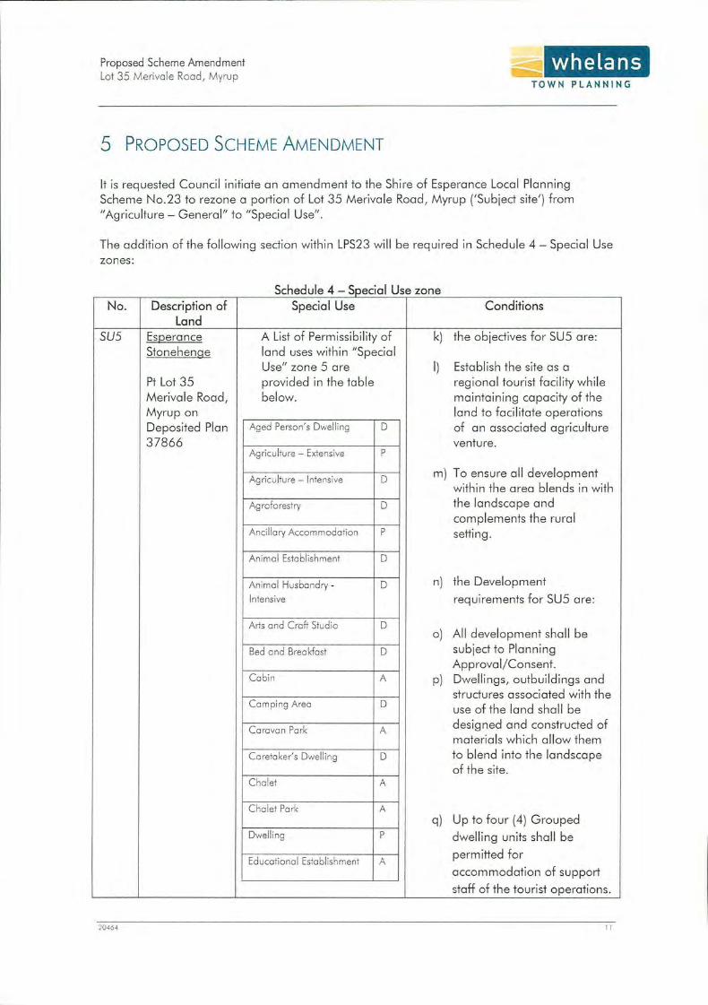
5 PROPOSED SCHEME AMENDMENT
whelans PLANNING
It is requested Council initiate an amendment to the Shire of Esperance Local Planning Scheme No.23 to rezone a portion of Lot 35 Merivale Road , Myrup ('Subject site') from "Agriculture - General" to "Special Use" .
The addition of the following section within LPS23 w ill be required in Schedule 4 - Special Use zones:
c e u e - >pecta Shd l 4 S ' I U se zone
No. Description of Special Use Conditions Land
sus Esgerance A List of Permissibility of k) the objectives for SUS are: Stonehenge land uses within "Special
Use" zone 5 are I) Establish the site as a Pt Lot 35 provided in the table regional tourist facility while Merivale Road, below. maintaining capacity of the Myrup on land to facilitate operations Deposited Plan Aged Person' s Dwelling D of an associated agriculture 37866 venture.
Agriculture- Extensive p
Agriculture - Intensive D m) To ensure all development w ithin the area blends in with
Ag roforestry D the landscape and complements the rural
Ancillary Accommodation p setting.
An imal Establishment D
Animal Husbandry - D n) the Development
Intensive requirements for SUS are:
Arts and Craft Studio D A ll development shall be o)
Bed and Breakfast D subject to Planning Approval / Consent.
Cabin A p) Dwellings, outbuildings and structures associated with the
Camping Area D use of the land shall be
Caravan Park A designed and constructed of materials which allow them
Caretaker's Dwelling D to blend into the landscape of the site.
Chalet A
Chalet Park A q) Up to four (4) Grouped
Dwelli ng p dwelling units shall be
Educational Establishment A permitted for
accommodation of support
staff of the tourist operations.
204 64 II

Proposed Scheme Amendment Lot 35 Meriva le Road, Myrup
20464
Exh ibition Centre
Family Day Core
Farm Stay
Fuel Depot
Garden Centre
Guesthouse
Health Farm
Holiday Cottages
Holiday Home
Home Business
Home Business- Rural
Home Occupation
Home Office
Home Store
Hostel
Industry - Cottage
Industry- Rural
Nursery
Pork Home Park
Place of Worsh ip
Produce Store
Reception Centre
Recreation - Private
Residential Building
Restaurant
Rural Pursuit
Single Bedroom Dwel ling
Stables
Telecommunications
whelans TOWN PLANNING
D This will have a Perm issibility
D of 'A'.
D r) The disposal of liquid and/ or
D solid wastes shall be carried
out with an effluent disposal
D system approved by Council
and the Health Department D
of Western Australia.
D
s) Provision shall be made to A
Council's satisfaction to
D ensure prospective
purchasers of land within p
Special Use zone SUS are
D given a copy of these
conditions prior to entering p
into an agreement to acquire
p any property.
D t) La nd capability assessments
D wi ll be required for any significant works on site to
D demonstrate suitability. Hydrological surveys may also
A be req uired to determine what
D can be serviced by groundwater.
D
A
A
A
A
D
A
p
D
p
D
12

Proposed Scheme Amendment Lot 35 Meriva le Road, Myrup
20464
Infrastructu re
Transport Depot
Veterinary Centre
whelans T OWN PLANNING
D
D
13

Proposed Scheme Amendment Lot 35 Merivale Road, Myrup
whelans TOWN PLANNING
6 JUSTIFICATION
The rezoning is intended to facilitate the subdivision and subsequ ent development of the land. The
'Stonehenge' replica tourist attraction has been in operation for 3 years on the Subiect site and
has been a successful tourist operation. The Landowner advises the replica attraction (with advice
from Tourism WA) has the potential for further growth and accommodate spin -off tourist facilities.
The change of zone to "Special Use" will facilitate the desired subdivision of the land allowing the
tourist attraction to stand alone and become a viab le bus· ness opportunity to a specialist tourist
operator.
The intention of the "Special Use" zone over this portion of the Subiect site is to establish a clear
intent for the long term development of the site as a regional tourism facility whil e also retaining
the capacity of the site to continue viab le agricultural activities. As such, the proposed Scheme
amendment retains the maiority of the current Permissible (P),Discretionary (D), and Advertising
Required (A) uses under the current "Agriculture- Genera l" zone. The full list of uses are provided
within "Special Use" table under schedule 4.
By recognition of the site as a regional tourism facility wi thin the Scheme, it is intended that the site
will be subdivided into an 90ha allotment to facilitate further development in line with the
established intent of SUS while also allowing for ongoing operation as an agricultural property.
Al lowi ng the change of zone wi ll allow a subdivision creating a new lot of approximately 90ha.
The Landown er has had previous correspondence (letter ddted the 281h March 20 14) wi th the Shire
to advise why this lot size is so important. The points were express were :
20464
• The Lot size would allow the continued running of livestock. The benefits of this are they
are assist in the control of weeds and grasses on parts of the land that are not able to be
sprayed or mowed. As a regional tourist attraction the keeping of livestock on this site
allows for tourist interaction with the animals in a regional setting.
• It wi ll allow livestock to move freely through wetter months avoiding areas that can become
inundated and should be avoided to prevent erosion.
• The use of existing fence lines will stop new fences being erected on steep slopes. Livestock
following these fence lines can contri bute to increase erosion.
• Bore water on the eastern side of the entry into the p~operty currently supplies water to the
'Stonehenge' replica including the existing house and lawns. There is no suitable bore
water on the western boundary.
• The proposed future subdivision boundary to the east needs to take in a large area of well
drained land to capture a good supply of underground water. There is no such land that
runs along the neighbours creek on the western boundary
14

Proposed Scheme Amendment Lot 35 Merivale Road , Myrup
~ .... whelans TOWN PLANNING
• A suitable area is required for future development within th e new lot. There is potentia l for
a caravan park, short stay cabins, a restaurant/ function centre, and micro-brewery, all of which wou ld require a large lot to accommodate development in an appropriate rural
setting.
In light of the preced ing report and justification provided, support for the proposed scheme
amendment is respectfully sought at the earliest opportun ity.
20464 15

Proposed Scheme Amendment Lot 35 Merivale Road, Myrup
whelans TOWN PLANNING
PLANNING & DEVELOPMENT ACT 2005
SHIRE OF ESPERANCE
DISTRICT TOWN PLANNING SCHEME NO. 23
AMENDMENT NO. 18
RESOLVED that the Council, in pursuance of Section 75 of the Plann ing and Development Act 2005, amend the above local planning scheme by:
1. Rezoning of lot 35 Merivale Road, M yrup, f rom "Agriculture - General" zone to " Special- Use"; and
2. In the table contained in Schedule 4, after Special Use Zone 4 (SU4) insert the follow ing :
sus Esgerance A List of Permissibi lity of u) the objectives for SU5 are: Stonehenge land uses within "Special
Use" zone 5 are v) Establish the site as a Pt Lot 35 provided in the table regional tourist facility while Merivale Road, below. maintaining capacity of the Myrup on land to facilitate operations Deposited Plan Aged Person's Dwel ling D of an associated agricu lture 37866 venture.
Agricu lture- Extensive p
Agriculture- Intensive D w) To ensure a ll development w ithin the area blends in w ith
Ag rofo restry D the landscape and complements the rural
Ancillary Accommodation p setting.
An ima l Establishment D
Anima l Husbandry - D x) the Development
Intensive requirements for SU5 are:
Arts and Craft Studio D y) All development shall be
Bed ond Breakfast D subject to Planning Approval / Consent.
Cabin A z) Dwellings , outbuildings and structures associated with the
Camping Area D use of the land shall be
Caravan Park A designed and constructed of materials which allow them
Caretaker's Dwelling D to blend into the landscape of the site.
20464 16

Proposed Scheme Amendment Lot 35 Merivale Road, Myrup
20464
Chalet
Chalet Park
Dwelling
Educational Establishment
Exhibition Centre
Family Day Care
Farm Stay
Fuel Depot
Garden Centre
Guesthouse
Health Farm
Holiday Cottag es
Holiday Home
Home Business
Home Business- Rural
Home Occupation
Home Office
Home Store
Hostel
Industry - Cottage
Industry - Rural
Nursery
Park Home Park
Place of Worship
Produce Store
Reception Centre
Recreation - Private
Residential Building
Restaurant
A
A
p
A
D
D
D
D
D
D
D
A
D
p
D
p
p
D
D
D
A
D
D
A
A
A
A
D
A
whelans TOWN PLANNING
aa) Up to four (4) Grouped
dwelling units shall be
permitted for
accommodation of support
staff of the tourist operations.
This will have a Permissibility
of 'A'.
bb) The disposal of liquid and/ or
solid wastes shall be carried
out with an effluent disposal
system approved by Council
and the Health Department
of Western Australia.
cc) Provision shall be made to
Council's satisfaction to
ensure prospective
purchasers of land within
Special Use zone SU5 are
given a copy of these
conditions prior to entering
into an agreement to acquire
any property.
dd) Land capability assessments
wil l be required for any
significant works on site to
demonstrate suitability.
Hydrological surveys may also
be required to determine what
can be serviced by
groundwater.
17

Proposed Scheme Amendment Lot 35 Merivale Road , Myrup
20464
Rural Pursu it
Single Bedroom Dwell ing
Stables
Telecommunications
Infrastructure
Transport Depot
Veterinary Centre
whelans TOWN PLANNING
p
D
p
D
D
D
18

Proposed Scheme Amendment Lot 35 Merivole Rood , Myrup
ADOPTION
whelans TOWN PLANNING
Adopted by resolution of the Council of the Shire of Esperance on the 24~
day of __ fa._~_u._W_g)-+------ 2015.
SHIRE PRESIDENT
CHIEF EXECUTIVE OFFICER
20464 19

Proposed Scheme Amendment Lot 35 Merivale Road, Myrup
FINAL APPROVAL
whelans ~ ..... TOWN PLANNING
Adopted for Final Approval by resolution of the Council of the Shi re of Esperance on
the
dayof ----------~~--------- 20 and the
Common Seal of the Shi re of Esperance was hereunto affixed by the authority of a
resolution of the Council in the presence of:
Recommended/Submitted for Final Approval
Final Approval Granted
20-164
SHIRE PRESIDENT
CHIEF EXECUTIVE O FFICER
Delegated under S.16 of the PO Act 2005
Date
Minister for Planning
Date
20

Proposed Scheme Amendment Lot 35 Merivole Rood , Myrup
APPENDIX 1 -CERTIFICATE OF TITLE
20464
whelans TOWN PLANNING
18

REG!~TER NUMBER
lti 35/DP37866
WESTERN AUSTRALIA
Dl JP!.I lCATE I DATE DUPLICATE lSSlJED EDmoN
1 8/10/2003
RECORD OF CERTIFICATE OF TITLE VOLUME
UNDER THE TRANSFER OF LAND A 1893
"The person described in the first schedu le is the registered proprietor of an estate in fee simple in the land described below subj ect to the reservat ions, condit ions and depth limit contained in the original grant (if a grant issued) and to the limitations, interests, encumbrances and notifications shown in the second schedule.
2544
REGISTRAR OF TITLES
LAND DESCRIPTION: LOT 35 ON DEPOSITED PLAN 37866
REGISTERED PROPRIETOR: (FIRST SCHEDULE)
KIMBERLEY HOWARD STEWART BEALE JTILIAN MAREE BEALE BOTH OF RMB 4323 , ESPERANCE
AS JOINT TENANTS
I. I586283
(AF I586282 ) REGISTERED 11 AUGUST 2003
LIMITATIONS, INTERESTS, ENCUMBRANCES AND NOTIFICATIONS: (SECOND SCHEDULE)
MORTGAGE TO RABOBANK AUSTRALIA L TO REGISTERED 11.8.2003.
Warning: A current search of the sketch ofth e land should be obtained where detai l of posi tion, dimensions or area of the lot is required. • Any entries preceded by an asterisk may not appear on the current edition ofthe duplicat certificate of title. Lot as described in the land description may be a lot or location.
FOLIO
691
---------------------------------------------------END OF CERTIFICATE OF TITI,LE--------------------------------------------------
STATEMENTS: TI1e statements set out below are not intended to be nor should they be relied on as substitutes for inspection of the land
and the relevant documents or for local govenunent, legal, surveying or other professional advice.
SKETCH OF LAND: PREVIOUS TITLE: PROPERTY STREET ADDRESS: LOCAL GOVERNMENT AREA :
DP37866. 2215-359, 2215-358. LOT 35 MERIVALE RD, MYRUP. SHIRE OF ESPERANCE.
LANDGATE COPY OF ORIGINAL NOT TO SCALE Fri Oct 24 11:54:21 2014 JOB 45960268
Landgate www.landgate.wa.gov.au

~ i;> , [ s:u
crq :::::J ~ Q, fl> tQ ::;:: ll) "' -~ CD < p., ~
r )> z 0 G) )> -l m 0 0 """0 -< 0 "T1
0 ::0 G)
z )> r z 0 -l -l 0 (f)
0 )> r m
"T1 -,
0 ~ N .f>. -->. -->.
CJl .f>. N -->.
N 0 -->.
.f>.
c._
0 aJ
.f>. CJl (.0
O"l 0 N O"l 00
"""""= ===::; """"1:J
=c.> = -.. g;: ; == = ~
802
LIMITED IN DEPTH TO 60.96 METRES
29
13849
OP 130131 ICP P14511
(3131.6~ origl
~ 72U8orig
·~ '•·,_"' ----,.---~8;;04;;.,:;,-;,..;;;g~---1 ... 1;1.
l .... o. o,.:'P
o ... :'P
lo.,,.,~. o,.~
\ •<i''-t.'0(\1},
MFQ''o\
~p
35 34 101"20'2s..HF~
.,,~,-;.~ '"' ;,)'". 1.'~- S'..>. 431.4987 ha
804 OP 1301 31 ICP P14511
281.4055 ha -~
~ '",_ . .,, .... ~... ~ ..
'\.,..,~ ~-~,.
(6' ••
i ~ ~ ~ ,?
... •' "':.~, ·" ~,, ~ l •">' 93692 P'""'9 <. /:11;/ t:i 6"<t•s, 1135 ... P·"Ig ;! l ' '' 6195< or>g OH 317.38 ~ Iii 216.26 .or/ ZQI. Z< 648.38 orig .. ~. :i;!_,8 ::,
GRAHAM GA TH SURVEYS LICENSED SURVEYOR
P.O. BOX 789 ESPERANCE W.A. ~450
MER IV ALE 12011.8 per ~~ I OHR ROAD "'
STATUTORY REFERENCE
Soil lr L.and (on_str"Utlon Act 1145. Sl!ction l0181
.J'.r,r '"'! · . .,-.,. r
~- 11: ~ <:?,
- ~
3006.4 orig
4' ~'<'
~
~'~ ,;< . ~'\.· ,,
LOT
35
I FORMER PI/TENURE ON PlAN\DIAGRAH TITLE 1m• FREEHOLD
I
~ .... ";.:,>,.,.
PT LOT 33 OP 28155 CIT ZZ1S/l S'1 \PURPOSE ..... ~~~QJ Y.I~I.Q~ . . .
LOT 32 DP 28155 CIT 2215/35~ ~~~-~ PT LQ~ 33 CIT 2215/359
o,.~
ij
OP 261.55
30
13849
. " o~\1), •'Jr(•{J
\.,~ ,j.IC,
~ ' ' '\) c;:,'r' '<'
~ LANDMARK L•nd lnftlfmatlo n &. Drafting S.......,ioMI 133 Sovborough B•aol'l Road PO Box g:g. Mount Hawthorn weetern A~nlla 801 e · Telephon• 8242 2285 F•x 9443 1386
LM11080
LOTS 34 AND 35
DISTRICT ... ..E.~~~~-~~~~-- - .. . .... . I SSA ~/NO
OOLA LOCAL AUTHORITY ... •
.. ~-~ ~~~- .?.~ . ~-~~-~~-~~-~ ~ ... . LOCALITY . ~X~~~- .. .
ON
INOE~ .. . .... ... . ........ . ..... . . . MT HERIVALEtSOI &
PUBLIC_ .. ~J: . 1''!9ml.~AIN . $~_qt ..
SEE TABLE"
FIELD BOOK
&9965
SCALE: 1:12500 21! t
2f' 4'1 'r
··---- - . .. "'" "' • - •• I ~-"""'""' " ' "n""" no r . ... ..... _.. ~;,;;;-.-;;-;:;;;-; (fAT . ... ,., .. . . "•• ~·
L~B~~~-'!~.I:..~t! __ I!_A_T~ lw..,. t .. llfJ lht.l l'tllfll • <ON MI rtptu~l•l ... •fiMnntJW/flf ·~•I"IMf..-..•...--t• ... Of'do-4 .. 111oo llool4 _._, .... 4 f flf tht,...,.otMI'IIIIIjoluUHithlll
•Hflllll•""'""•tl-1-'"'*'"' la..WIIrtl&tltollo~tllfl.,..,_
IN "ORDER FOR DEALINGS .
SJaJ(CffD ••
.. .'':[~.~ - - .. 0.~~-L ... .. ..... .
~-~+.-i';,iiiii~i·.·; .·~~=--~~~-·j:.~.- -- ~~-- ""GATi" "
APPROVED·
· wi«oa·ontbt -~·~-~-lJ~~ -'--~-~ ·o·.-n··
A.ooLA c.-- ol L..Ar-1> .AD.v.NISTR.AllCtf
DEPOSHED PLAN
3786'6 ~ --·· · ·'· ·· · · · mtlOII •. . 1 .... ... .

Proposed Scheme Amendment Lot 35 Merivale Road , Myrup
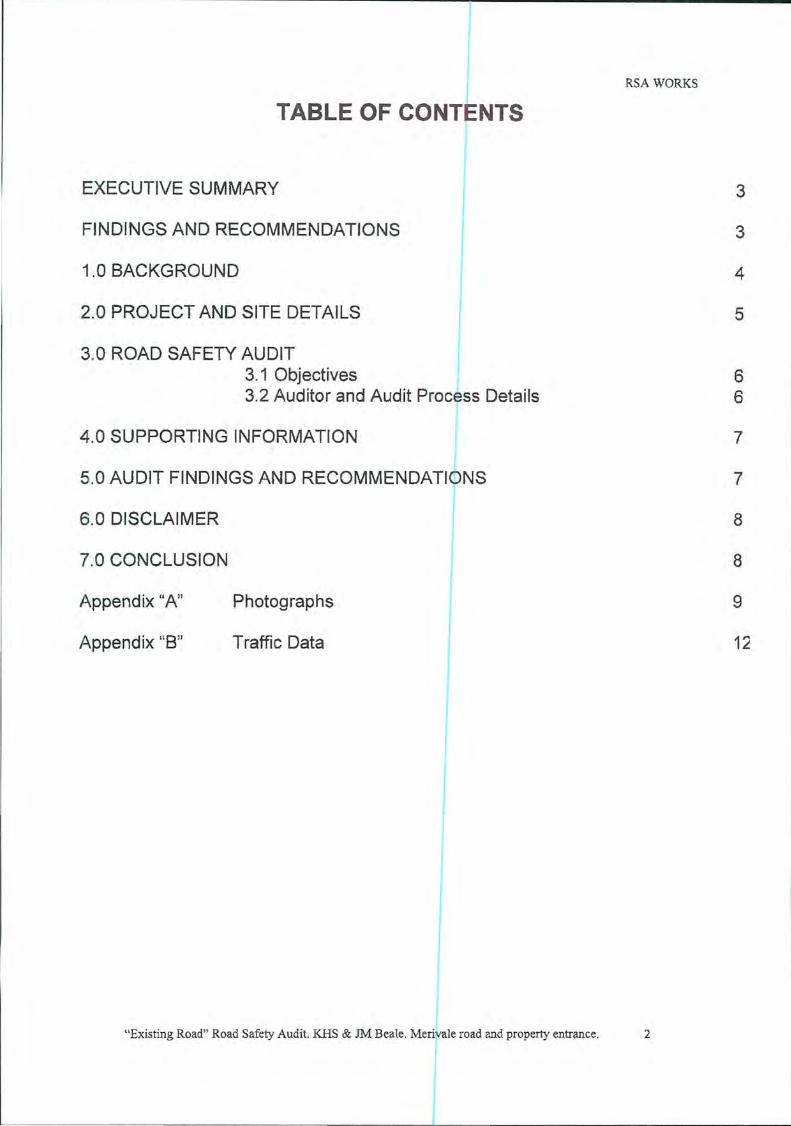
APPENDIX 2- ROAD SAFETY AUDIT
20464
~ .... whelans TOWN PLANNING
19

RSA WORKS
ROAO SAFETY AUDIT
Existing road and property entrance including proposed nev'l acc.es
- re · a red for the KHS & JM Beale
Merivale road from SLK 7.540 8.620 onc~uding property access for KHS & JM Beale
~· -· . ' I:' I$
r~-.....:.:..~,_.~~ I .~ . . : II? .~ ---.... ..
J .. • ... ! . •
" t ~. ·,
4th February 2011
Team leader - Keith Dickerson - RSA Works
Member - Cheryl Dickerson - RSA Works
"Existing Road" Road Safety Audit. KHS & JM Beale. Merivale road and property entrance.
RSA WORKS
TABLE OF CONTENTS
EXECUTIVE SUMMARY
FINDINGS AND RECOMMENDATIONS
1.0 BACKGROUND
2.0 PROJECT AND SITE DETAILS
3.0 ROAD SAFETY AUDIT 3.1 Objectives 3.2 Auditor and Audit Process Details
4.0 SUPPORTING INFORMATION
5.0 AUDIT FINDINGS AND RECOMMENDATIONS
6.0 DISCLAIMER
7.0 CONCLUSION
Appendix "A" Photographs
Appendix "B" Traffic Data
"Existing Road" Road Safety Audit. KHS & JM Beale. Merivale road and property entrance. 2
3
3
4
5
6 6
7
7
8
8
9
12

RSA WORKS
EXECUTIVE SUMMARY;
Location;
Merivale road from SLK 7.540 to SLK 8.610 and property entrance
Site Description;
Merivale road is an undivided t.No-way major east west road with a 6.2 to 7 metre wide bitumen surface that extends from Dempster road to Fisheries road via Poison Creek road . Merivale road services the farming community to the east of Esperance and carries a high number of tourist traffic visiting beaches and holiday destinations eg; Cape Le Grand National Park, Duke of Orleans Bay and Poison Creek. It is used by all classes of vehicles including oversized agricultural equipment, grain and stock trucks, tourist traffic and heavy haulage.
The existing property entrance is located on the northern side of Merivale road at SLK 8.330 with 495 metres of sight distance to the East and 307 metres west to the crest of the vertical curve on Merivale road at SLK 8.063.
The existing property entrance has complying sight distances in both directions along Merivale road, it is a good width with suitable swept paths for large turning vehicles such as caravans, mobile homes and heavy vehicles and is suitable for increased numbers of vehicles entering and leaving the property at such time when the proposed tourist attraction is completed .
Traffic data included in this report at appendix "B"; was collected south of Fisheries road during the peak period (January and February 2010 and indicates an average daily count of 523 vehicles with a percentage of heavy haulage.
Crash Data for the section of Merivale road referred to in this audit has not been included as it would be irrelevant to the proposed new property entrance at SLK 7.620, however the construction of the new entrance with the vertical curve on Merivale road in its current state would create a serious Black Spot and increase the crash risk to an unacceptable level.
The speed is derestricted on Merivale road it is contained within a 50 metre wide road reserve and under the control of the Shire of Esperance.
Orientation;
For the purpose of this report Merivale road is considered to have an east/west orientation.
FINDINGS AND RECOMMENDATIONS;
This Road Safety Audit has been carried out for the purpose of identifying safety issues at the existing property entrance on Merivale road at SLK 8.330 and a proposed new entry
"Existing Road" Road Safety Audit KHS & JM Beale. Merivale road and property entrance. 3

RSA WORKS
point at SLK 7.620 and the following recommendations are highlighted for consideration and implementation.
The existing property entrance compiies with ail reJuired standards and is suitable for an entry and exit point for traffic visiting stage one of the proposed Stone Henge tourist attraction; however consideration needs to be given to a percentage of traffic that will park on the shoulders of Merivale road on the approach to the crest of the vertical curve to look at the attraction from outside the property, this will create a dangerous situation and could be overcome by some form of screening inside the property eg; trees.
The second property entrance proposed to be constructed to the west of the existing entrance at SLK 7.620 will however require a considerable amount of remedial work at the crest of the vertical curve on Merivale road to increase the sight distance to the east along Merivale road to a complying and safe distance.
No specific work is required at the existing property entrance; however following the construction of the tourist attraction on the property, suitable tourist advisory sign age would help to improve safety at the attraction entrance.
If the attraction increases in popularity and further facilities are developed and a second access point is required then the following remedial work will be required;
• Design a suitable vertical curve to increase the sight line from the proposed new access point to a complying distance. Reduction of the crest of the vertical curve will also further increase the sight distance to the west of the existing property entrance.
• Apply the design and reduce the crest of the vertical curve on Merivale road at SLK 8.063 to the west of the existing entrance to increase the sight distance to comply with standards to the east along Merivale road.
• Widening of the formation and bitumen surface of Merivale road on both sides approaching the proposed new access in accordance with all AustRoads and Australian standards to provide a safe situation for all road users.
• Review and upgrade all signage, road markings, raised pavement markers and guide posts associated with the upgraded access.
1.0 BACKGROUND;
The Shire of Esperance requested Mr Kim Beale have an "Existing Road" Road Safety Audit carried out on the section of Merivale road extending past the southern boundary of the property where the proposed construction of a tourist attraction is to be constructed as there is concerns with increased traffic numbers and safety accessing the site.
The inspection of the section of Merivale road , the existing property entrance and the proposed new access highlighted the need for remedial work on the crest of the vertical curve on Merivale road to increase sight distances to comply with all AustRoads and Australian standards and to remove the risk of high speed side, front and rear end crashes accruing with the expected increased traffic numbers.
"Existing Road" Road Safety Audit. KHS & JM Beale. Merivale road and property entrance. 4

RSA WORKS
2.0 PROJECT AND SITE DETAILS;
The objective of this project is to assist Mr Kim Beale and the Shire of Esperance provide safe and complying access to a proposed tourist attraction on Merivale road east of Esperance and prevent the creation of a potential black spot in the area.
The remedial works required to upgrade the poorly designed vertical curve on Merivale road, as described in the findings and recommendations, includes the reduction of the crest of the vertical curve to the west of the existing property entrance, the widening of the road formation and bitumen surface, and the upgrade of all signage road markings and guide posts.
Merivale road is as described in the Executive Summary with the following specific features relevant to the property access;
SLK
7.540
7.580
7.620
7.745
7.922
8.063
8.085
8.202
8.330
8.370
8.458
8.529
8.538
8.579
8.592
8.596
Property access on the North side
Culvert structure 13 metres wide with one X 1200mm, two X 600mm reinforced concrete pipes and two X 450mm asbestos pipes with stone pitched headwalls on both sides
Location of proposed new property access to the Beale property
Property entrance on the south side
Start of double centre llne markings
End of double centre line markings
Crest of the vertical curve
Property entrance on the south side
Existing entrance to the Beale property
Back of trucks entering advisory sign
Start of recent work. bitumen surface widens to 7.5 metres
Size 8 curve advisory sign on a frangible post
Start of horizontal curve
Start of double centre line markings
End of the horizontal curve
Back of size 8 curve advisory sign on a frangible post
"Existing Road" Road Safety Audit. KHS & JM Beale. Merivale road and property entrance. 5

RSA WORKS
8.610 End of recent work, bitumen surface narrows to 6.5 metres
8.620 End of Audit
3.0 ROAD SAFETY AUDIT;
3.1 Objectives
A road Safety Audit is an assessment and report on the safety and compliance of a section of road or configuration of roads, pathways and property access and is not intended to rate or recommend a particular design of the project being audited.
This report will address the objectives of a Road Safety Audit and the recommendations made within the report will offer direction for solutions to safety problems rather than offering design details .
The objectives of this Road Safety Audit are:
• To inspect and review the existing section of Merivale road from SLK 7.540 to SLK 8.610, an existing property entrance and a proposed new access and ascertain the safety standard of them in there current state.
• From the inspection and review form conclusions regarding the safety and crash potential of the site.
• Report on the findings of the inspection and make recommendations for the upgrading of Merivale road from SLK 7.540 to SLK 8.610, an existing property entrance and a proposed new access to a safe and complying standard.
3.2 Auditor and Audit Process Details
This report is a result of an audit requested by the S~ire of Esperance and Mr Kim Beale for the section of Merivale road from SLK 7.540 to SLK 8.610 and property access to the site of a proposed tourist attraction which could create a potential black spot and increase the risk of high speed side, front and rear impact type crashes if compliance is not met.
The site inspection was carried out on Monday 1oth January 2011
The Audit Team;
Team Leader Keith Dickerson RSAWorks
Team Member Cheryl Dickerson RSAWorks
"Existing Road" Road Safety Audit. KHS & JM Beale. Merivale road and property entrance. 6
J

RSA WORKS
4.0 SUPPORTING INFORMATION;
Photograph Appendix "A''
Traffic data Appendix "8"
5.0 AUDIT FINDINGS AND RECOMMENDATIONS;
Existing property entrance design;
Design, signs and sight distances associated with the existing entrance to the Beale property at SLK 8.330 on Merivale road complies with all AustRoads and Australian standards with sight distances of 307 metres to the West and 495 metres to the East.
Recommendation;
No remedial work associated with this property entrance is essential; however following the construction of the tourist attraction some form of screening inside the property would reduce the number of vehicles stopping on and approaching the crest of the vertical curve on Merivale road. Tourist information signage on the approaches to the property access would tend to slow approaching traffic and improve safety in the area. (Liaise with the Esperance Shire regarding signage standards).
Findings and recommendations associated with the construction of a second property access at SLK 7.620 on Merivale road;
Road design;
The current design of Merivale road through the vertical curve does not offer complying sight distances to the point of the proposed new property access.
Recommendation;
Liaise with the Shire of Esperance to encourage them to redesign and reconstruct the section of Merivale road on the approaches to the crest of the vertical curve at SLK 8.085 to increase the sight distance to the East along Merivale road to a complying distance from the point of the proposed new property access.
The sight distance without remedial work and reduction of the crest of the vertical curve on Merivale road is well below standard and would increase the crash risk and create a Black Spot.
As there is a wide road reserve through the section of Merivale road past the point of the proposed new property access the engineers design may include the reduction of the crest of the vertical curve, the widening of the road surface, the inclusion of acceleration and deceleration lanes and road markings.
"Existing Road" Road Safety Audit. KHS & JM Beale. Merivale road and property entrance. 7

RSA WORKS
6.0 DISCLAIMER;
This is a final report. It has been referred to the audit for variation of statements purporting to be fact and for comment on its conclusions and recommendations. This report contains the findings, opinions and recommendations of the audit team based on the examination of the audit site as described within this document. Notwithstanding that this report may contain statements in relation to technical matters, both of a general nature and in relation to specific issues; in no way should readers of this report rely solely on its content for application elsewhere. Readers must seek appropriate expert advice on there own particular circumstances and rely on such advice".
7.0 CONCLUSION;
This Road Safety Audit has been completed for the purpose of identifying existing safety issues associated with the previously described Beale property entrance at SLK 8.330 on the north side of Merivale road and safety issues that would be created by the construction of a proposed second property entrance at SLK 7.620 on Merivale road.
The existing property entrance complies with all Australian and AustRoads standards; however screening and signage as previously highlighted would improve traffic safety in the area. The reduction of the crest of the vertical curve to facilitate the proposed second property entrance could also increase the sight distance from the existing access.
To achieve a complying and safe second property access at SLK 7.620 will require close consultation and planning with the Esperance Shire as highlighted in the Audit Findings and Recommendations.
Upgrading of the section of Merivale road through the vertical curve would benefit the Shire of Esperance by way of removing an existing potential Black Spot from their road network and offer motorists a safer road. (The Shire of Esperance may consider making application for Federal or and state Black Spot funding to assist with the funding of this project).
This road safety audit was carried out following the procedures in AustRoads Guidelines for Road Safety Auditing and recommendations in this report are presented for consideration and implementation.
Keith C Dickerson, Senior Road Safety Auditor "Certification# 0148" the proprietor of RSA Works will be pleased to discuss any aspect of this report.
Keith C Dickerson
RSA Works
P 0 Box 34 Wickepin WA 6370
Phone 0427 391 625 "Existing Road" Road Safety Audit. KHS & JM Beale. Merivale road and property entrance. 8

RSA WORKS
Appendix "A"
From the existing property access looking east highlighting complying sight dist~1nce
From the existing property access looking west highlighting complying sight distance
"Existing Road" Road Safety Audit. KHS & 1M Beale. Merivale road and property entrance. 9

RSA WORKS
From the location of the proposed new property access looking east highlighting the reduced sight distance to the crest of the vertical curve
From the location of the proposed new property access looking west highlighting the complying sight distance
"Existing Road" Road Safety Audit. KHS & JM Beale. Me,rivale road and property entrance. 10

RSA WORKS
From SLK 7.540 looking east up Merivale Hill with a grade of approximately 9%
"Existing Road" Road Safety Audit. KHS & JM Beale. Merivale road and property entrance. 11

RSA WORKS
Appendix "8"
Cl•n !;F"YJ lc.t.t dx S:Xn'U Ot fl !.Htll!t~ hfMU )J J 27 'lhur~~y, ~.t 1:-o~M~ulr 10\U . ,.. llt;•~ W~O~"tt'.lJ. •t• 10 r.- t~.u:. , r 01 0
:S po..""'~ l kn/hl !\JX•QO 7\lt:.l ~
Cllu,.
l U ll I ?
10 20 8 .I 0.0 1
20 - lO It 1- . I 19 D.U
lO • ~0 .. ,I •• o. n
co . !.0 12fi 2~ 20 I I . I I !I 11.~1
5<11 · ~I 15~ ! 0 '11 1\1 ,, d H! ) .!'\
£0- 70 t 2U•: l~IJ ~ I ? s !0 n II I I d Hl~ tD. l\
10 - 60 H46 H~ 21 ~ '" n " JO 1!1 . I !>211 20 . ~ ·
ao - 90 ~Ol& J>l liD " It " I I . I ",, H.U
w- lUO HU 190 ZJL 10 I) . I ')1:1 1 10.8\
100- 110 11oe so "' . I 21~0 II. H
110 - IZO !ll n (.) . I ~n ),01
120 - JlO 209 I I . I ?H Q,i,
uo - 140 62 .I GJ O. H
149 - ! SO I " .I n 0.11
ISO - lEO It .t 14 o.n
2199 4 IJlO l) ~{l ,.
'~ !13 H !4 )Z ~, 01 2)116
B? . U !1.3\ ) . H 0,]\ 0.0\ 0.)\ 0.2 \ 0 ,2\ o. n O:.li O.J\ 0 . 0 \1
"Existing Road" Road Safety Audit. KHS & JM Beale. Merivale road and property entrance. 12

Proposed Scheme Amendment Lot 35 Merivale Road , Myrup
APPENDIX 3 -SUPPORTING CORRESPONDENCE
20464
whelans TO W N PLA NN ING
20

Our Ref: Tourism WA File:
014/962 GOV/0388
Ms Jillian Beale Esperance Stonehenge Merivale Road ESPERANCE WA 6450
Dear Jillian and Kim
, .. ("\,.~·· ; -~ . ..... . t .. I . ' "--- ~: . ,·
WESTERN AUS TRALIA
2 Mill Street PERTH WA 6000
GPO Box X2261 PERTH WA 6847
Telephone +61 8 9262 1700 Facsimile +61 8 9262 1702
[email protected] .gov.au
tourism.wa.gov .au
Thank you for providing Renata Lowe and I with a tour of Esperance Stonehenge.
It is quite an experience to walk through a full scale Stonehenge replica. I was amazed at the sheer size of the granite pillars, the systematic layout and the incredible acoustics that is formed.
We talked in general about the opportunities that the Esperance Stonehenge could leverage from cruise ship visits and from cultivating small events. What a perfect location for small opera and music events and even the opportunity to watch a movie on the lovely lawns surrounded by the pink granite structures under a night sky.
You mentioned your interest in implementing a subdivision to the large rural block with the idea to establish a tourism precinct that would include Esperance Stonehenge and a large area for future caravan park development. I mentioned that Tourism WA employs several Town Planners who could provide feedback on your subdivision application and facilitate connections with the Department of Planning should you require our assistance.
You also mentioned a desire to promote your attraction to tour operators and that you have recently made contact with Adams Coashlines (owner of Australian Pinnacle Tours). I encourage you to take up Jac Eerbeek's offer to attend a meeting with Adams when you are next in Perth. I would also like to suggest that you contact Mr Anthony Hayes, Managing Director AAT Kings, ([email protected]) who can direct you to the person in his organisation responsible for planning Western Australian itineraries.
Thank you again for making time to meet with Renata Lowe and myself and to welcome us to your property.
Yours sincerely
STEPHANIE BUCKLAND Chief Executive Officer
26 March 2014

--
28th March, 2014.
Mr Richard Hindley Director Development Services Shire of Esperance PO Box 507, Windich Street Esperance WA 6450
Mssrs Kim and Jillian Beale Esperance Stonehenge
RMB 4323, Merivale Road Esperance WA 6450
RE: Land Uses and Subdivision Potential - Lot 35 Merivale Road, Esperance.
Dear Richard
Further to our conversation about the reasons for a variation on the size of the area for subdivision on Lot 35 Myrup, Merivale Road, Esperance.
Reason for subdivision is to separate a tourism venture that has been operating very successfully for nearly three years. ( Full size replica of UK Stonehenge built of Esperance Pink Granite ). The whole of Lot 35, has been listed for sale. We have received enquiry on the Tourism Business (Esperance Stonehenge Tourist Attraction) which does not include the whole farm. Lot 35 Myrup, Merivale Road falls within precinct 50 of the local planning strategy which only allows for a maximum of a 20 hectare homestead lot subdivision.
We would like a variation to extend the area to around 30ha or even 90ha, which would create a far better shape to the subdivision and be more environmentally friendly for land use.
Points to support the 30ha/90ha proposal: • Use existing fence lines ( 2 new fences would still be required)
• Fences would not run down steep slopes. (Livestock tracking following fence lines up and down encourages erosion).
• It gives a better proportion of dryer land to heavier land which can become boggy during winter and should not have livestock running on it while it is very wet.
• A reasonable size area is required to be able to run some livestock to control the grasses and weeds as there is at least 8ha that could not be mowed or sprayed, and if not controlled would create a huge fire risk.
• Tourists viewing and photographing farm animals is very much part of the attraction,
• The bore water on the eastern side of the entry to the property is required for the Esperance Stonehenge Subdivision ( It currently supplies water to 90ha of lot 35 as well as house gardens, lawns and Esperance Stonehenge lawn.) There is no suitable

bore water on the heavy land on the western boundary which follows the neighbours creek.
• Therefore eastern boundary subdivision needs to take in a reasonable area of light land to sustain a good supply of suitable water.
Negative Points for 20ha Subdivision:
• Not enough area to maintain a suitable number of livestock.
• Very poor positioning of new boundaries (would encourage soil erosion)
• Poor shape to remaining area of Lot 35, also would encourage erosion problems.
• Not enough area for future development. Eg Caravan Park, Chalets, Eco-tourism, Restaurant and Micro Brewery. (These are all strong possibilities for future development at Esperance Stonehenge.
We believe that Esperance Stonehenge, which sits on the proposed subdivision overlooking the ocean, Esperance Bay and Esperance Townsite, has huge potential for major development to encourage further tourism to the Esperance and WA regions. We are reminded every day of the potential of this attraction by visiting National and International tourists. Over three years ago when we took on this project of Esperance Stonehenge, the Shire President at the time, Mr lan Mickel, CEO Mal Osborne and the Councillors of the day, were all supportive of what we proposed to build and advised us that if we ever looked at Subdivision to "Make sure there was enough land for future development". I would suggest that we would have the same support from our current Councillors.
On the 20th of March, 2014, we had the CEO of Tourism WA, Stephanie Buckland, and Renata Lowe, Director Projects Infrastructure and Investment, visited Esperance Stonehenge and were totally amazed at what we have built in Esperance. They also see the huge potential of future development that could occur and the asset that it would be to Esperance and WA Tourism. Renata Lowe would be keen to help and support our proposed subdivision and after having been on the site, understands the need for a larger piece of land.
I personally believe, if I was the purchaser of Esperance Stonehenge, I would be looking for a subdivision of 88ha-90ha which would follow two existing fence lines, and that would allow for even better land management. This would leave 341 ha of Lot 35's total of 431 ha.
Therefore, the question we are asking is for a subdivision of .@efta-or-even 90ha? We hope this proposal can be looked at objectively and consider all the relevant reasons for increasing the land area from 20ha in the subdivision.
Yours faithfully,
Kim and Jillian Beale Esperance Stonehenge 08-90759003 Email: [email protected]

' --YOUR REF
OUR REF F13/351- 013/22264
ENQUIRIES Development Services (08} 9071 0676
DATE 12 DECEMBER 2013
K H &J M Beale RMB 4323 Esperance WA 6450
Dear Mr & Mrs Beale
Y -O·
Shire of
Esperance w~ llllllh te '-11-1
LAND USES AND SUBDIVISION POTENTIAL- LOT 35 MERIVALE ROAD, MYRUP
Further to your enquiries, 1 advise the following:
Lot 35 Merivale Road, Merivale is zoned "Agriculture - General" under Local Planning Scheme No. 23.
The permitted land uses in the "Agriculture - General" zone are as follows:
• Abbatoir, Aged Persons Dwelling, Agriculture -:- Extensive, Agriculture -Intensive, Agroforestry, Airfield, Ancillary Accommodation, Animal Establishment, Animal Husbandry - Intensive, Arts and Craft Studio, Bed and Breakfast, Builder's Storage Yard, Cabin, Camping Area, Caravan Park, Caretaker's Dwelling, Chalet, Chalet Park, Dwelling, Earthmoving Equipment -Depot for, Educational Establishment, Exhibition Centre, Family Day Care, Farm Stay, Fish Processing, Garden Centre, Grain Depot, Guesthouse, Health Farm, Holiday Cottages, Holiday Home, Home Business, Home Business - Rural, Home Occupation, Home Office, Home Store, Hostel, Industry - Extractive, Industry -Hazardous, Industry - Mining, Industry - Rural, Industry - Cottage, Kennels and/or Cattery, Motel, Place of Worship, Produce Store, Reception Centre, Recreation - Private, Residential Building, Restaurant, Rural Pursuit, Single Bedroom Dwelling, Stables, Stock Holding and Sales Yard, Telecommunications Infrastructure, Transient Workforce Accommodation, Transport Depot, Veterinary Centre, Winery, Woodyard.
Non-permitted land uses in the "Agriculture - General" zone are as follows:
• Amusement Facility, Amusement Parlour, Boat Building, Car Park, Child Care Premises, Club Premises, Consulting Rooms, Convenience Store, Dry Cleaning Establishment, Fast Food Outlet, Fish Processing, Funeral Parlour, Group Dwelling, Hotel, Industry - General, Industry - Light, Industry - Service, Laundromat, Lunch Bar, Marine, Marine Filling Station, Market, Medical Centre, Motor Vehicle Repair, Motor Vehicle Repair - Major, Motor Vehide Wash, Motor Vehicle Boat or Caravan Sales Premises, Night Club, Nursing Home1 Office, Park Home Park, Restricted Premises, Salvage Yard, Service Station, Serviced Apartment, Shop, Showroom, Supermarket, Tavern, Tourist Report, Warehouse, Wrecking Premises.
SHIRE OF ESPERANCE PO Sox 5(}7 Esperance WA 6450 T: (08) 9071 0666 F: (08) 9071 0600 E: [email protected] .. au www.esperance.wa.gov.au

y
Discussions have been held with the Department of Planning who have advised that other than meeting the provisions of State Planning Policy 2.5 - Land Use Planning in Rural Areas and Development Control Policy 3.4- Subdivision of Rural Land there is no support for any subdivision. If a homestead lot is pursued under the provisions of Development Control Policy 3.4 a maximum potential lot size of 20ha is possible and it must contain the dwelling and respond to landform.
Should you have any queries relating to this matter, please do not hesitate to contact the undersigned by phone on (08) 9071 0676 or by email at rk:[email protected].
Yours faithfully /j
Richard · ley Director of Development Services
SHIRE OF ESPERANCE PO Box 507 Esperance WA 6450 T: (06) 9071 0666 F: {06) 9071 0600 E: [email protected] www.esperance.wa.gov.au

l
Proposed Scheme Amendment Lot 35 Merivale Road , Myrup
APPENDIX 4 -SCHEME AMENDMENT PLAN
20464
whelans TOWN PLANNING
21

SHIRE OF ESPERANCE TOWN PLANNING SCHEME No. 21
SCA5
MERRIVALE
EXISTING ZONING
MERRIVALE
SCHEME(AMENDMENT)MAP
-Amendment No.
LEGEND ZONES
D Agriculture- General
OTHER Special Use Area (See Scheme Text)
~ Special Control Area ~ (See Scheme Text)
SCALE 1 :40 000