
Ship Tracking Data - European Commission · PDF fileShip Tracking Data (STD) 4 Positioning...
13
Brussels, 7 July 2015 Carlos Pereira - Project Officer Marine Environment & Enforcement Ship Tracking Data ESSF MRV SG on Verification & Accreditation
Transcript of Ship Tracking Data - European Commission · PDF fileShip Tracking Data (STD) 4 Positioning...

Brussels, 7 July 2015
Carlos Pereira - Project Officer
Marine Environment & Enforcement
Ship Tracking Data
ESSF MRV SG on Verification & Accreditation
Ship Tracking Data (STD)
2

Ship Tracking Data (STD)
3
As per IMO Requirements under SOLAS
- Navigation Log-Book,
- Nautical Charts,
- Electronic Chart Display and Information System ECDIS
Coastal/Global Positioning Systems such as…
- Automatic Identification System AIS
- Long-Range Identification and Tracking LRIT

Ship Tracking Data (STD)
4
Positioning Systems - AIS overview
- Capable of providing information about the ship to other ships and to
shore/coastal authorities, including the ship's identity, type, position,
course, speed, navigational status and other safety-related information
automatically.
- Regulation 19 of SOLAS Chapter V - Carriage requirements for shipborne
navigational systems and equipment - fitted aboard all ships of 300 GT
and upwards engaged on international voyages, cargo ships of 500 GT
tonnage and upwards not engaged on international voyages and all
passenger ships irrespective of size. The requirement became effective
for all ships by 31 December 2004.
- Ships fitted with AIS shall maintain AIS in operation at all times except
where international agreements, rules or standards provide for the
protection of navigational information.

Ship Tracking Data (STD)
5
Positioning Systems - LRIT overview
- Capable of providing information about the global identification and
tracking of a ship. The main purpose of the LRIT ship position reports is to
enable a Contracting Government to obtain ship identity and location
information.
- Regulation V/19-1 of SOLAS - sets the obligations of ships to transmit
LRIT information and the rights and obligations of SOLAS Contracting
Governments and of Search and Rescue services to receive LRIT
information. The LRIT system is mandatory for all passenger ships, high
speed craft, mobile offshore drilling units and cargo ships of over 300 GT.
- Similarly to AIS, LRIT shall be maintained in operation at all times.
Ship Tracking Data (STD)
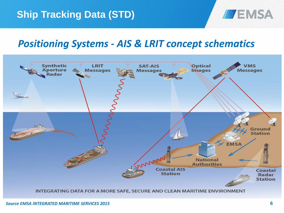
6
Positioning Systems - AIS & LRIT concept schematics
Source EMSA INTEGRATED MARITIME SERVICES 2015

Ship Tracking Data (STD)
7
Positioning Systems - AIS & LRIT concept schematics
Source EMSA INTEGRATED MARITIME SERVICES 2015
Ship Tracking Data (STD)
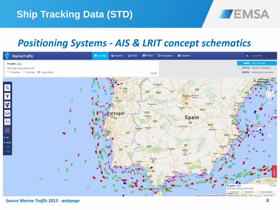
8
Positioning Systems - AIS & LRIT concept schematics
Source Marine Traffic 2015 - webpage

Ship Tracking Data (STD)
9
Key aspects related to Positioning/Activity Systems
- Ship movements i.e. activity data can be detected by using other
ship tracking sources besides AIS and LRIT e.g. port calls.
- Ships’ activity data is already available from both commercial and
non-commercial sources being the last previously authorised by
the ‘owners’ of such data i.e. Member States or Contracting
Governments.
- AIS can be made available from both satellite and terrestrial
tracking systems. Although satellite sources are becoming more
reliable, shore-based coastal systems (radio and radar) are still
more accurate and complete, particularly w.r.t. high density traffic
areas e.g. large ports.

Ship Tracking Data (STD)
10
Key aspects related to Positioning/Activity Systems
- Biggest advantage of these systems is that the information is
remotely available i.e. time positioning, routing and true sailed
distances.
- Resolution, quality and uncertainty will highly depend on the
sources and procedures to collect and treat ships’ data.
- Confidence in quality and minimizing uncertainty highlight the
importance of an improved AIS/LRIT coverage. An increased and
combined use of satellite and terrestrial positioning systems will
contribute to obtaining a more complete and robust maritime
activity picture while increasing the accuracy of ships’ tracking for
verification purposes.

EU & International Research/Studies
11 Source EMSA&FMI 2012 Cooperation - Exhaust emissions from ship traffic in the SafeSeaNet area during 2011
EU & International Research/Studies
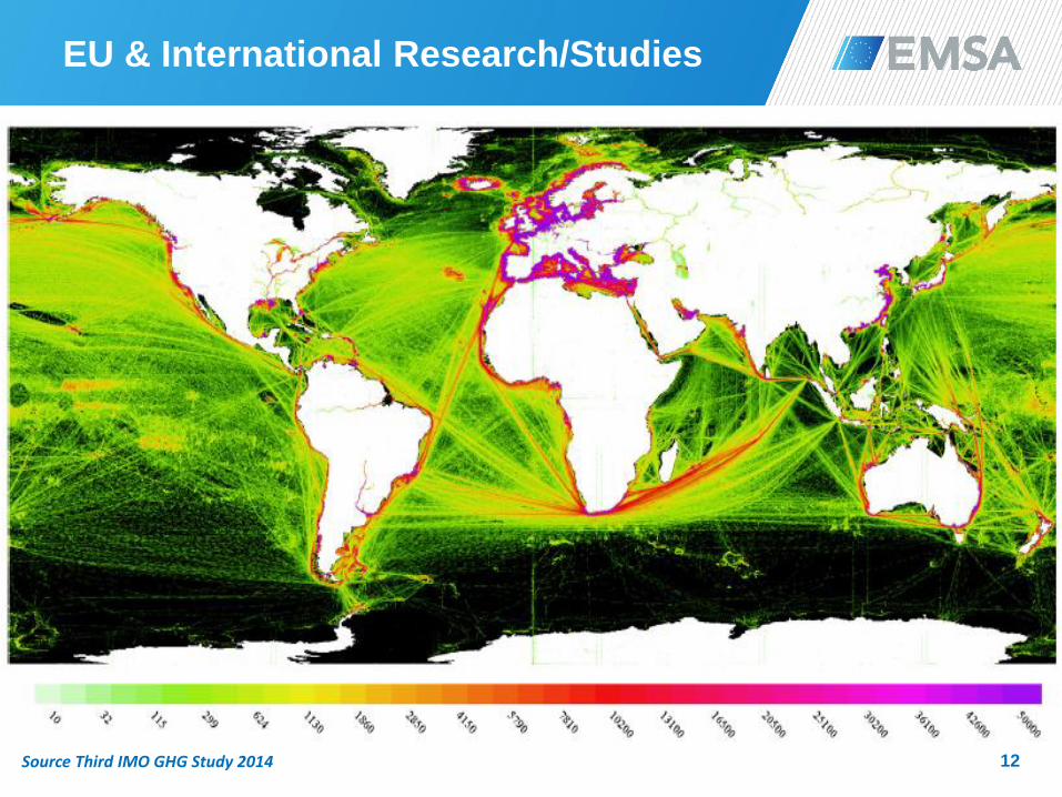
12 Source Third IMO GHG Study 2014
twitter.com/emsa
facebook.com/emsa
Questions?
Thank you!
emsa.europa.eu


