Shell Exploration & Production - United States Fish and …€¦ · · 2013-07-26Shell...
47
Shell Exploration & Production February 9, 2010 Shell U.S. Fish and Wildlife Service 3601 C Street, Suite 1000 Marine Mammals Management Anchorage, AK 99503 Attn: Craig Perham Tel. (907) 646-7112 1011 East Tudor Road, MS-341 Email [email protected] Anchorage, AK 99503 Internet http://www.shell.com / Re: Request for Letter of Authorization (LOA) for the Incidental Take of Polar Bears and Pacific Walrus and the Intentional Take of Polar Bears by Harassment; 2010 Proposed Open Water Marine Surveys Program Activities, Chukchi Sea (“2010 Chukchi Sea program”) Dear Mr. Perham: Beginning in July 2010 and, depending on ice weather conditions, possibly continuing through October, Shell Gulf of Mexico, Inc. (Shell) plans to conduct marine survey activities in the Chukchi Sea. Shell’s planned 2010 marine surveys include an ice gouge survey, marine environmental baseline studies, and a seafloor soil sampling program. Shell requests an LOA from the U.S. Fish and Wildlife Service (USFWS) for the non-lethal incidental, unintentional take of small numbers of polar bear and Pacific walrus and the intentional take of polar bears by harassment. This letter is submitted to fulfill the requirements regarding incidental, unintentional “take” of protected marine mammals pursuant to 50 Code of Federal Regulations (CFR) Part 18. The governing regulations are entitled, Nonlethal Taking of Marine Mammals Incidental to Oil and Gas Exploration, Development, and Production Activities in the Chukchi Sea. Because the planned surveys are weather and ice dependent, the exact dates of the surveys and device deployments cannot be determined at this time. Due to the proposed time frames for and locations of the activities, conflicts with subsistence activities will likely be avoided. As part of the application for obtaining an LOA from the USFWS, Shell has developed a Plan of Cooperation (POC) in accordance with 50 CFR 18. The POC specifies measures that Shell will take to minimize adverse effects on marine mammals when proposed activities may affect the availability of a species or stock of marine mammals for Arctic subsistence uses or when proposed activities are conducted near a traditional subsistence hunting area. Shell will begin the POC activities in the 1 st quarter of 2010 with POC meetings in Barrow, Point Lay, Wainwright, Kotzebue, and Point Hope. Shell met most recently with the marine mammal commissioners of the Eskimo Walrus Commission, Alaska Beluga Whale Committee, Alaska Ice Seal Committee, and Alaska Nanuq Commission during a meeting held in Anchorage on December 8, 2009, to discuss the 2010 programs. Follow-up consultations with these marine mammal commissions and committees will occur prior to the start of the 2010 marine survey program. At the upcoming community and future marine mammal commissioner consultations, Shell will continue to present its programs and will be prepared to discuss local concerns regarding the potential impacts to subsistence activities or resources.
Transcript of Shell Exploration & Production - United States Fish and …€¦ · · 2013-07-26Shell...

Shell Exploration & Production
February 9, 2010 Shell U.S. Fish and Wildlife Service 3601 C Street, Suite 1000 Marine Mammals Management Anchorage, AK 99503 Attn: Craig Perham Tel. (907) 646-7112 1011 East Tudor Road, MS-341 Email [email protected] Anchorage, AK 99503 Internet http://www.shell.com/ Re: Request for Letter of Authorization (LOA) for the Incidental Take of Polar Bears and
Pacific Walrus and the Intentional Take of Polar Bears by Harassment; 2010 Proposed Open Water Marine Surveys Program Activities, Chukchi Sea (“2010 Chukchi Sea program”)
Dear Mr. Perham: Beginning in July 2010 and, depending on ice weather conditions, possibly continuing through October, Shell Gulf of Mexico, Inc. (Shell) plans to conduct marine survey activities in the Chukchi Sea. Shell’s planned 2010 marine surveys include an ice gouge survey, marine environmental baseline studies, and a seafloor soil sampling program. Shell requests an LOA from the U.S. Fish and Wildlife Service (USFWS) for the non-lethal incidental, unintentional take of small numbers of polar bear and Pacific walrus and the intentional take of polar bears by harassment. This letter is submitted to fulfill the requirements regarding incidental, unintentional “take” of protected marine mammals pursuant to 50 Code of Federal Regulations (CFR) Part 18. The governing regulations are entitled, Nonlethal Taking of Marine Mammals Incidental to Oil and Gas Exploration, Development, and Production Activities in the Chukchi Sea. Because the planned surveys are weather and ice dependent, the exact dates of the surveys and device deployments cannot be determined at this time. Due to the proposed time frames for and locations of the activities, conflicts with subsistence activities will likely be avoided. As part of the application for obtaining an LOA from the USFWS, Shell has developed a Plan of Cooperation (POC) in accordance with 50 CFR 18. The POC specifies measures that Shell will take to minimize adverse effects on marine mammals when proposed activities may affect the availability of a species or stock of marine mammals for Arctic subsistence uses or when proposed activities are conducted near a traditional subsistence hunting area. Shell will begin the POC activities in the 1st quarter of 2010 with POC meetings in Barrow, Point Lay, Wainwright, Kotzebue, and Point Hope. Shell met most recently with the marine mammal commissioners of the Eskimo Walrus Commission, Alaska Beluga Whale Committee, Alaska Ice Seal Committee, and Alaska Nanuq Commission during a meeting held in Anchorage on December 8, 2009, to discuss the 2010 programs. Follow-up consultations with these marine mammal commissions and committees will occur prior to the start of the 2010 marine survey program. At the upcoming community and future marine mammal commissioner consultations, Shell will continue to present its programs and will be prepared to discuss local concerns regarding the potential impacts to subsistence activities or resources.

February 9, 2010 U.S. Fish and Wildlife Service Page 2 Any potential impacts from the planned projects on the polar bear and Pacific walrus populations of the Chukchi Sea are likely to be short-term and transitory (i.e., the temporary displacement of individuals or small groups of marine mammals that may be exposed to the proposed activities). The proposed activities will not result in any permanent impact on habitats used by marine mammals or their prey. As outlined in the attached, Shell will take appropriate measures to prevent unreasonable impacts on the availability of marine mammals for subsistence users. Items required pursuant to 50 CFR 18 are attached. A more complete activity description is provided in Addendum 2010-01, 2010 Marine Surveys Program Activities - Chukchi Sea (Attachment A). Addendum 2010-01 is a supplement to the USFWS-approved Polar Bear and Pacific Walrus Awareness and Interaction Plan, North Slope and Chukchi Sea, Alaska; April 2008. The 2010 Marine Mammal Monitoring and Mitigation Plan is attached to Addendum 2010-01, as Attachment B to this letter. If you have any questions regarding this submission, please contact me at (907) 646-7112 or at [email protected], or Walt Sandel at (907) 646-7154 or at [email protected]. Sincerely,
Susan Childs Regulatory Affairs Manager, Alaska Venture Enclosures: Attachment A – Addendum 2010-01, Proposed Open Water Marine Surveys Program
Activities – Chukchi Sea Attachment B – Marine Mammal Monitoring and Mitigation Plan cc with attachment: Jeff Walker, U.S. Department of the Interior, Minerals Management Service, Anchorage Joel Garlich-Miller, USFWS Don Perrin, Large Projects Coordinator, Alaska Department of Natural Resources Project File Administrative Record
Bear Avoidance, Encounter, and Interaction Plan Alaska North Slope, Beaufort and Chukchi Seas
Shell Gulf of Mexico Inc. February 2010 V.0
ADDENDUM 2010-01
2010 PROPOSED OPEN WATER MARINE SURVEY PROGRAM ACTIVITIES – CHUKCHI SEA

Bear Avoidance, Encounter, and Interaction Plan Alaska North Slope, Beaufort and Chukchi Seas
Shell Gulf of Mexico Inc. Page i February 2010 V.0
2010 PROPOSED OPEN WATER MARINE SURVEY PROGRAM ACTIVITIES – CHUKCHI SEA
Executive Summary
As described herein, during 2010 Shell Gulf of Mexico, Inc. (Shell) plans to conduct marine surveys designed to gather additional data relative to ice gouge, seafloor sediments, and marine ecosystems in select areas of the Chukchi Sea. Shell acquired its Chukchi Sea Outer Continental Shelf (OCS) leases at lease sale (LS) 193 in 2008.
Surveys of ice gouge features will obtain information to aid in predicting the prospect of, orientation, depth, and frequency of future ice gouges into seafloor sediment by ice keels that project from the bottom of moving ice. The seafloor soil sampling program is proposed in the OCS of Chukchi Sea. Seafloor soil sampling will be conducted from a marine vessel via borings into the seabed to obtain shallow depth soil cores (~20 feet below seafloor) for analysis of geotechnical soil parameters. The marine environmental baseline studies will collect site-specific biological and physical media samples, marine wildlife survey, and provide an opportunity to determine the presence of potential sensitive ecological receptors.
The marine surveys planned by Shell are industry-standard, scientific surveys that have been routinely conducted in the Beaufort and Chukchi Seas since the early 1980s, as well as elsewhere in the world’s oceans. These types of surveys, collectively and individually, have not resulted in impacts of biological significance to marine mammals of the Arctic, or interference with the subsistence harvest of those marine mammals by the residents of the communities along the Beaufort or Chukchi Seas.
Shell also plans the deployment of scientific data devices in the Chukchi Sea OCS during 2010. Near Shell’s Burger prospect, a floating buoy will collect meteorological and oceanographic (metaocean) data and an Acoustic Waves and Currents (AWAC) meter will collect current data at the seafloor, and underwater Ocean Bottom Hydrophones (OBHs) which will be deployed as arrays outward from the Chukchi Sea coastline. The OBHs are anchored underwater buoys that record marine mammal vocalizations and other underwater sounds.
Shell will conduct a Marine Mammal Monitoring and Mitigation Program (4MP) for its 2010 program activities in the Chukchi Sea. The goal of the 4MP is to develop a program that supports protection of the marine mammal resources in the area, fulfills reporting obligations to the U.S. Fish and Wildlife Service (USFWS) and provides data useful for monitoring and understanding the impacts of survey activities on Pacific walrus and polar bear. The 4MP for 2010 program activities is attached to this addendum.
This request for Letter of Authorization (LOA) complies with the provisions of Title 50 Code of Federal Regulations (CFR), Part 18, Subpart I - Nonlethal Taking of Pacific Walruses and Polar Bears Incidental to Oil and Gas Exploration Activities in the Chukchi Sea and Adjacent Coast of Alaska.
Bear Avoidance, Encounter, and Interaction Plan Alaska North Slope, Beaufort and Chukchi Seas
Shell Gulf of Mexico Inc. Page 1 February 2010 V.0
ADDENDUM 2010-01
2010 PROPOSED OPEN WATER MARINE SURVEY PROGRAM ACTIVITIES – CHUKCHI SEA
1.0 SPECIFIC PROJECT ACTIVITIES Shell Gulf of Mexico Inc. (Shell), plans to complete the following surveys in partnership with contractors during the 2010 open-water marine survey season (collectively the proposed open water marine survey program, hereinafter referred to as the “Program”) in the Chukchi Sea:
Ice gouge survey;
Marine environmental baseline studies; and
Seafloor soil sampling.
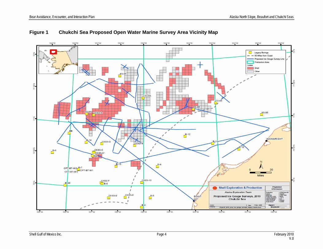
As part of the feasibility study for Shell's Alaskan prospects a survey is required to identify and evaluate seabed conditions. Shell intends to conduct an ice gouge survey, a seafloor soil sampling, and marine environmental baseline studies in the Chukchi Sea during the 2010 open water season. The seafloor survey has two main components; an ice gouge survey and a seafloor soil sampling program. The 2010 ice gouge surveys will be conducted using the conventional survey method where the acoustic instrumentation will be towed behind the survey vessel, or possibly with the use of an Autonomous Underwater Vehicle (AUV). The same acoustic instrumentation will be used during both AUV and the conventional survey methods. The AUV is a self-propelled autonomous vehicle that will be equipped with acoustic instrumentation and programmed for remote operation over the seafloor where the ice gouge survey is to be conducted, and the vehicle is launched and retrieved from a marine vessel (Photo 1). Ice gouging is created by ice keels, which project from the bottom of moving ice and gouge into seafloor sediment. Ice gouge features are mapped, and by surveying each year, new gouges can be identified. The ice gouge information is used to aid in predicting the prospect of, orientation, depth, and frequency of future ice gouges. Ice gouge information is required for the design of potential pipelines and for the design of pipeline trenching and installation equipment to the Shell leases blocks in the Chukchi Sea. The proposed ice gouge survey and seafloor soil sampling will be conducted in both State of Alaska waters and the Federal waters of the Outer Continental Shelf (OCS) in the Chukchi Sea. Actual locations of the ice gouge surveys have not been definitively set as of this date, although these will occur within the area outlined in Figure 1. Before the commencement of operations, survey location information will be supplied to Minerals Management Service (MMS) as ancillary activities authorizations and other interested agencies as it becomes available.
The seafloor soil sampling program is required to understand the soil floor sediments. To understand the type and strength of soil, a seafloor soil investigation is needed. The primary objective is to collect soil samples to support of technology development for potential development. These surveys will focus on the potential, prospective pipeline corridor from the Alaska Chukchi Sea coastline, to the Shell leases blocks in the Chukchi Sea, and the other survey lines shown in Figure 1. Before the commencement of

Bear Avoidance, Encounter, and Interaction Plan Alaska North Slope, Beaufort and Chukchi Seas
Shell Gulf of Mexico Inc. Page 2 February 2010 V.0
operations, survey location information will be supplied to MMS as ancillary activities authorizations and other interested agencies as it becomes available.
The vessel that will be conducting these surveys may also be used in the deployment and retrieval of underwater Ocean Bottom Hydrophones (OBHs) which are a component of the marine mammal monitoring and mitigation program (4MP). Shell will execute a 4MP as a consequence of authorizations for non-lethal incidental harassment of marine mammals during the 2010 open water season. OBHs are anchored underwater buoys that record marine mammal vocalizations and other underwater sounds that may be deployed and/or retrieved from a vessel. A series of marine environmental baseline studies sampling are proposed as to supplement the data sets being used to evaluate environmental conditions in the Chukchi Sea. These are a continuation of baseline studies begun in 2008. The baseline studies will collect additional site-specific biological and physical media samples, provide an opportunity to determine the presence of potential sensitive ecological receptors, and provide information on the area of influence of potential offshore oil and gas activities. All marine vessel and aircraft will operate in accordance with the provisions of a Plan of Cooperation (POC). The POC is developed to mitigate effects of Shell’s proposed programs where activities would take place in or near a traditional arctic subsistence hunting area and/or may affect the availability of a species for subsistence uses. Shell will consult with affected Chukchi Sea communities (see Section 1.10) and marine mammal associations for the development of the POC. 1.1 Type of Equipment
During the 2010 open water season, Shell plans to complete marine surveys designed to gather additional data relative to ice gouge, seafloor soil, and the marine ecosystem in select areas of the Chukchi Sea. Only the ice gouge survey will deploy acoustic sources from a vessel.
1.1.1 Ice Gouge Survey
The ice gouge survey will be conducted with the following acoustic instrumentation used during 2008 ice gouge surveys that will again be used during 2010:
Dual Frequency subbottom profiler; (2 to 7 kilohertz [kHz] or 8 to 23 kHz); Multi-beam bathymetric sonar; (240 Hz); or similar and Side-scan sonar system; (190 to 210 kHz), or similar.
1.1. 2 Marine Environmental Baseline Studies
These studies will focus on the potential, prospective pipeline corridor between the Shell lease blocks in the Chukchi Sea, and the Alaska Chukchi Sea Coastline (Figure 1). The research activity will include deployment of oceanographic equipment for collecting sediment samples (e.g., Double van-Veen sampler, clam dredge) and water quality samples (e.g., framed-CTD sampler, six bottle rosette sampler), deployment of various types of nets (plankton nets, Bongos, benthic and pelagic trawls) for collecting zooplankton and fish species. Biologists will also make observations of marine and coastal birds, and marine mammals using standardized survey transect methods and binoculars/range finders. Use of the research vessel by collaborative agencies or organizations to capture and tag marine mammals and/or marine and coastal birds is a low possibility. Use of underwater noise generating equipment is not anticipated. A floating buoy may be deployed from a vessel to collect metaocean data in the Chukchi Sea with an accompanying AWAC meter deployed to collect current data at the seafloor.
Bear Avoidance, Encounter, and Interaction Plan Alaska North Slope, Beaufort and Chukchi Seas
Shell Gulf of Mexico Inc. Page 3 February 2010 V.0
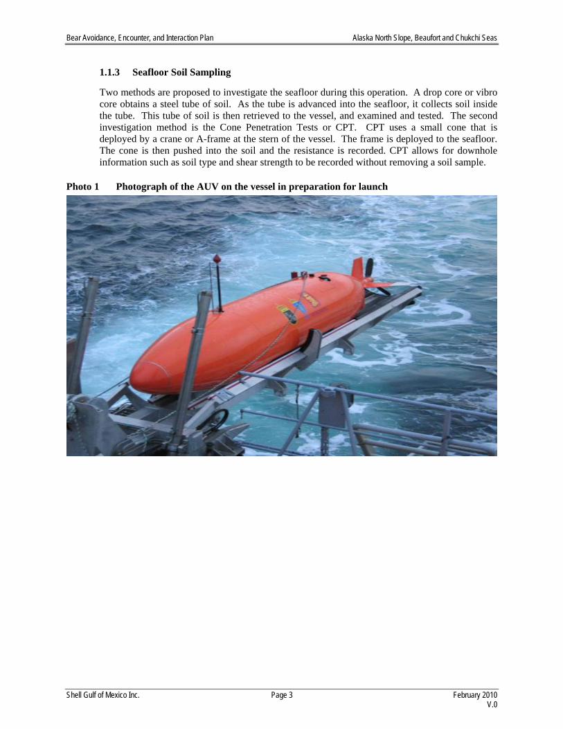
1.1.3 Seafloor Soil Sampling
Two methods are proposed to investigate the seafloor during this operation. A drop core or vibro core obtains a steel tube of soil. As the tube is advanced into the seafloor, it collects soil inside the tube. This tube of soil is then retrieved to the vessel, and examined and tested. The second investigation method is the Cone Penetration Tests or CPT. CPT uses a small cone that is deployed by a crane or A-frame at the stern of the vessel. The frame is deployed to the seafloor. The cone is then pushed into the soil and the resistance is recorded. CPT allows for downhole information such as soil type and shear strength to be recorded without removing a soil sample.
Photo 1 Photograph of the AUV on the vessel in preparation for launch
Bear Avoidance, Encounter, and Interaction Plan Alaska North Slope, Beaufort and Chukchi Seas
Shell Gulf of Mexico Inc. Page 4 February 2010 V.0
Figure 1 Chukchi Sea Proposed Open Water Marine Survey Area Vicinity Map

Bear Avoidance, Encounter, and Interaction Plan Alaska North Slope, Beaufort and Chukchi Seas
Shell Gulf of Mexico Inc. Page 5 February 2010 V.0
1.2 Vessel Specifications
Each of these individual surveys will require marine vessels to accomplish the work. Vessels that are anticipated to be under contract to Shell, or a contractor to Shell, at the time of this LOA request are specifically named herein. In this LOA request, Shell describes the tasks that vessels are anticipated to conduct and, where possible, Shell may mention the name of a vessel previously contracted to perform such tasks. Also, the phrase “or similar vessel” is included because the vessel named in this application may or may not eventually be selected to conduct the work. Table 1 provides a comprehensive list of proposed vessel tasks to support the activities planned for coverage by an LOA to be issued for the open water period of 2010.
Table 1 Proposed Marine Vessels 2010 Chukchi Sea Open Water Marine Survey Program Chukchi Sea Marine Surveys Vessel Task Notional Operating Timeframe Proposed Vessel Ice Gouge July thru October R/V Mt. Mitchell, or similar vessel Marine Environmental Baseline Studies
July thru October Vessel similar to R/V Mt. Mitchell, or the Arctic Seal
Seafloor Soil Sampling July thru October R/V Mt. Mitchell, or similar vessel
1.2.1 Ice Gouge Survey
The vessel has not been selected, but it is anticipated that the vessel would be similar to the R/V Mt. Mitchell is 70 meters (m) (231 feet [ft]), 12.7 m (42 ft) wide, and 4.5 m (15 ft) draft.
1.2.2 Marine Environmental Baseline Studies
The vessel has not been selected, but it is anticipated that the vessel would be similar to the R/V Mt. Mitchell or the Arctic Seal. The R/V Mt. Mitchell is 70 m (231 ft), 12.7 m (42 ft) wide, and 4.5 m (15 ft) draft.
1.2.3 Seafloor Soil Sampling
The vessel has not been selected, but it is anticipated that the vessel would be similar to the R/V Mt. Mitchell is 70 meters (m) (231 ft), 12.7 m (42 ft) wide, and 4.5 m (15 ft) draft.
1.3 Search and Rescue
Shell may also contract a helicopter to provide emergency rescue/evacuation and search and rescue (SAR) services. If utilized, a SAR helicopter will be stationed at a location proximal to offshore activities sufficient to meet necessary health and safety response times. The SAR aircraft would fly intermittent training missions over the Chukchi Sea.
Bear Avoidance, Encounter, and Interaction Plan Alaska North Slope, Beaufort and Chukchi Seas
Shell Gulf of Mexico Inc. Page 6 February 2010 V.0
1.4 Number of Personnel
1.4.1 Ice Gouge Survey
The ice gouge survey will use one survey vessel with a capacity up to 25 to 30 crew. 1.4.2 Marine Environmental Baseline Studies
The marine baseline studies program will use one vessel with a crew of 15, including up to 10 Shell scientific/technical/support staff.
1.4.3 Seafloor Soil Sampling The seafloor soil sampling program will use one vessel, with a crew of approximately 25 to 30.
1.5 Task Descriptions (what are workers doing, proximity to site)
1.5.1 Ice Gouge Survey
These surveys will focus on the potential, prospective pipeline corridor between the Shell lease blocks in the Chukchi Sea and the Alaska Chukchi Sea Coastline (Figure 1). The area will be surveyed to gather geotechnical and seafloor hazard information as well as data on ice gouges. All crew will remain on board except during crew change.
1.5.2 Marine Environmental Baseline Studies
The objectives of this program are to expand the knowledge base and characterization of important ecosystem components in the marine environment including: 1) Benthic organisms, 2) Fish species, 3) Marine and coastal birds, and 4) Sensitive marine habitat (e.g., essential fish habitat). Benthic community samples will be collected in the area of interest to determine the composition and diversity of the benthic fauna. This sampling will occur simultaneously with the water quality sampling. Random sampling design will ensure that representative samples will be analyzed to identify the main benthic fauna and spatial differences between working areas. Sediment samples collected in the field will be subject to analytical protocols to measure heavy metal content, including mercury, cadmium, lead, zinc, and copper. The goal is to establish the natural baseline metal content in the sediment for later comparison with future monitoring data.
1.5.3 Seafloor Soil Sampling
The seafloor soil sampling program is necessary to develop additional data regarding seafloor soil sediments. To understand the type and strength of soil, a soil investigation is needed. The primary objective is to collect soil samples to support of technology development for the potential development.
Bear Avoidance, Encounter, and Interaction Plan Alaska North Slope, Beaufort and Chukchi Seas
Shell Gulf of Mexico Inc. Page 7 February 2010 V.0
1.6 Vehicle Access
Vehicle access would be limited to activities associated with the mobilization points for crew changes and resupply. This may include Wainwright, and Barrow. 1.7 Schedule of Operations
All operations will accommodate the operational restrictions imposed by the POC, and the NFMS IHA. 1.7.1 Ice Gouge Survey
This activity is proposed to be conducted July through October 2010. The total program will last a maximum of 45 days, excluding downtime due to weather and other unforeseen delays. 1.7.2 Marine Environmental Baseline Studies
This activity is proposed to commence during July 2010. As proposed, this program will last a maximum of 30 days, excluding downtime due to weather and other unforeseen delays, and should be complete by the end of October 2010.
1.7.3 Seafloor Soil Sampling
Shell is proposing to begin this program during July 2010, and conclude by the end of October. The program will last a maximum of 45 days excluding downtime due to weather and other unforeseen delays.
1.8 Daylight Hours (Visibility, etc.)
At the commencement of survey activities in July, the sun is above the horizon providing constant daylight in the activity area. Towards the end of the program at the end of October the amount of daylight is reduced to approximately 8 hours. 1.9 Proposed “Footprint” of Operation
1.9.1 Ice Gouge, Seafloor Soil Sampling
The ice gouge surveys are proposed for submerged federal waters in Chukchi Sea OCS. The prospective area of all activities is represented in Figure 1. The vessel will be working in waters under Federal and State jurisdiction. 1.9.2 Marine Environmental Baseline Studies
The marine environmental baseline studies are to take place in the Chukchi Sea OCS. The vessel will be working in waters under Federal and State jurisdiction.
1.10 Plan of Cooperation
Shell has developed a Plan of Cooperation (POC or Plan) pursuant to MMS Lease Sale Stipulation No. 5, which requires that all exploration operations be conducted in a manner that prevents unreasonable conflicts between oil and gas activities and the subsistence activities and resources of residents of the North Slope. This stipulation also requires adherence to USFWS and NMFS regulations, which require
Bear Avoidance, Encounter, and Interaction Plan Alaska North Slope, Beaufort and Chukchi Seas
Shell Gulf of Mexico Inc. Page 8 February 2010 V.0
an operator to implement a POC to mitigate the potential for conflicts between the proposed activity and traditional subsistence activities (50 CFR § 18.124(c)(4) and 50 CFR § 216.104(a)(12)). The POC identifies the measures that Shell has developed in consultation with North Slope subsistence communities and will implement during its planned 2010 open water marine surveys to minimize any adverse effects on the availability of marine mammals for subsistence uses. In addition, the POC details Shell’s communications and consultations with local subsistence communities concerning its planned 2010 program, potential conflicts with subsistence activities, and means of resolving any such conflicts (50 CFR § 18.128(d) and 50 CFR § 216.104(a) (12) (i), (ii), (iv)). Shell continues to document its contacts with the North Slope subsistence communities, as well as the substance of its communications with subsistence stakeholder groups. The POC was developed following numerous meetings and consultations between Shell, affected subsistence communities and stakeholders, and federal agencies. The POC identifies and documents potential conflicts and associated measures that will be taken to minimize any adverse effects on the availability of marine mammals for subsistence use. Outcomes of POC meetings are typically included in updates attached to the POC as addenda and distributed to federal, state, and local agencies as well as local stakeholder groups that either adjudicate or influence mitigation approaches for Shell’s open water programs. Meetings for Shell’s 2010 program in the Chukchi Sea are planned for Barrow, Point Hope, Point Lay, Wainwright, and Kotzebue in the 1st quarter of 2010. Shell met with the marine mammal commissions and committees including the Alaska Eskimo Whaling Commission (AEWC), Eskimo Walrus Commission (EWC), Alaska Beluga Whale Committee (ABWC), Alaska Ice Seal Committee (AISC), and the Alaska Nanuq Commission (ANC) on December 8, 2009 in co-management meeting. Throughout 2010 Shell anticipates continued engagement with the marine mammal commissions and committees active in the subsistence harvests and marine mammal research. Following the 2010 season, Shell intends to have a post-season co-management meeting with the commissioners and committee heads to discuss results of mitigation measures and outcomes of the preceding season. The goal of the post-season meeting is to build upon the knowledge base, discuss successful or unsuccessful outcomes of mitigation measures, and possibly refine plans or mitigation measures if necessary.
Shell is prepared to consult and share information obtained during implementation of our marine mammal monitoring program with a variety of groups who may find the data useful in their research. A suggested list of recipients includes:
The North Slope Borough (NSB) Department of Wildlife Management (T. Hepa)
The USFWS Office of Marine Mammal Management (C. Perham and J. Garlich-Miller)
The MMS’s Bowhead Whale Aerial Survey Program (C. Monnett)
Alaska Eskimo Whaling Commission (H. Brower - Barrow)
Alaska Beluga Whale Committee (W. Goodwin - Kotzebue)
Alaska Ice Seal Commission (John Goodwin)
Alaska Nanuq Commission (Charlie Johnson)
Eskimo Walrus Commission (Vera Metcalf)
Inupiat Community of the Arctic Slope (Martha Ipalook Faulk - Barrow)
Minerals Management Service – Resource Evaluation (R. Wall)

Bear Avoidance, Encounter, and Interaction Plan Alaska North Slope, Beaufort and Chukchi Seas
Shell Gulf of Mexico Inc. Page 9 February 2010 V.0
North Slope Science Initiative (J. Payne)
Alaska Department of Natural Resources (D. Perrin)
1.12 Permitting Requirements
MMS – Ancillary Activity Authorization
NMFS – Marine Mammal Protection Act (MMPA) IHA Application (including POC), Endangered Species Act (ESA) Biological Opinion
USFWS – MMPA LOA Polar Bears & Pacific Walrus (including POC)
Subsistence Stakeholders and Affected Communities – Plan of Cooperation
ADNR – Alaska Coastal Management Program (ACMP) Consistency Review, Geophysical Exploration Permit
NSB – Development Permit 1.13 Emergency Planning
Potential interactions with polar bears could occur throughout the operations during the 2010 open water marine surveys program in the Chukchi Sea. Temporary field camps or day-length landings of personnel and equipment may be necessary to support the program. Although active machinery and vehicles often deter bears from approaching the site, additional precautionary actions are also necessary. In addition to these measures, in the case of vessels seeking emergency refuge adjacent to the offshore islands personnel will be briefed in safety protocol relating the appropriate manner to manage encounters with wildlife.

MARINE MAMMAL MONITORING AND MITIGATIONPLAN
for
Shallow Hazards Surveys of Selected Lease Areas in the Alaskan Beaufort Sea in 2010
Shell Offshore Inc. Shell Gulf of Mexico Inc.
December 2009

Marine Mammal Monitoring and Mitigation Plan
for
Shallow Hazards Surveys of Selected Lease Areas in the Alaskan Beaufort Sea
December 2009
Table of Contents
ii
TABLE OF CONTENTS
TABLE OF CONTENTS ............................................................................................................................ II
ACRONYMS .............................................................................................................................................. III
INTRODUCTION ........................................................................................................................................ 1
VESSEL-BASED MARINE MAMMAL MONITORING PROGRAM .................................................. 1
INTRODUCTION ........................................................................................................................................... 1 MITIGATION MEASURES DURING SURVEY ACTIVITIES ............................................................................... 2
Safety and Disturbance Zones ............................................................................................................... 3 Power Downs and Shut Downs ............................................................................................................. 4 Ramp Ups .............................................................................................................................................. 4 Monitoring Prior to and during AUV deployment ................................................................................ 5
MARINE MAMMAL OBSERVERS .................................................................................................................. 5 Number of Observers ............................................................................................................................ 5 Crew Rotation ....................................................................................................................................... 5 Observer Qualifications and Training .................................................................................................. 6 MMO Handbook ................................................................................................................................... 6
MONITORING METHODOLOGY .................................................................................................................... 7 Monitoring At Night and In Poor Visibility .......................................................................................... 8 Specialized Field Equipment ................................................................................................................. 8 Field Data-Recording, Verification, Handling, and Security ............................................................... 8 Field Reports ......................................................................................................................................... 9
REPORTING ................................................................................................................................................. 9
AERIAL SURVEY PROGRAM ................................................................................................................. 9
OBJECTIVES ................................................................................................................................................ 9 SAFETY ..................................................................................................................................................... 10
Selection of Aircraft ............................................................................................................................ 10 SURVEY PROCEDURES .............................................................................................................................. 10 FLIGHT AND OBSERVATION PROCEDURES ................................................................................................... 10
Supplementary Data ............................................................................................................................ 11 Coordination with MMS/NMFS Aerial Surveys .................................................................................. 11
SURVEY DESIGN ....................................................................................................................................... 12 ANALYSIS OF AERIAL SURVEY DATA ....................................................................................................... 14
Estimation of Numbers “Taken” ......................................................................................................... 14 Effects of Survey Activities on Bowhead Migration ............................................................................ 15
ACOUSTIC MONITORING PLAN ......................................................................................................... 16
SOUND SOURCE MEASUREMENTS ............................................................................................................ 16 ACOUSTIC STUDY OF BOWHEAD DEFLECTIONS ........................................................................................ 17
Objective ............................................................................................................................................. 17 Monitoring Plan .................................................................................................................................. 18 Analysis assumptions: ......................................................................................................................... 21
ANALYSIS REPORT ................................................................................................................................... 21
COMPREHENSIVE REPORT ON INDUSTRY ACTIVITIES AND MARINE MAMMAL MONITORING EFFORTS IN THE BEAUFORT AND CHUKCHI SEAS ........................................ 22
LITERATURE CITED .............................................................................................................................. 23

iii
ACRONYMS
4MP Marine Mammal Monitoring and Mitigation Plan ADF&G Alaska Department of Fish and Game AEWC Alaska Eskimo Whaling Commission DASAR Directional Autonomous Seafloor Acoustic Recorder dB decibel CD Compact Disc Discoverer Frontier Discoverer GPS Global Positioning System ft feet Hz Hertz IHA Incidental Harassment Authorization kHz kilohertz km kilometer LGL LGL Alaska Research Associates, Inc. LOA Letter of Authorization m meters mi miles MMO Marine Mammal Observer MMS Minerals Management Service NMFS National Marine Fisheries Service NSB North Slope Borough NVD Night-vision Device rms Root Mean Square Scripps Scripps Institute of Oceanography Shell Shell Offshore Inc. SPL Sound Pressure Level USFWS U.S. Fish and Wildlife Service

Beaufort Sea Marine Mammal Monitoring and Mitigation Plan
1
INTRODUCTION
Shell Offshore Inc., the lessee for Outer Continental Shelf (OCS) leases in the Beaufort Sea, and Shell Gulf of Mexico Inc., the lessee for OCS leases in the Chukchi Sea, collectively known as Shell submits the following Marine Mammal Monitoring and Mitigation Program (4MP) for shallow hazards survey activities in the Beaufort Sea during the 2010 open-water season. The 4MP developed for Shell’s 2010 shallow hazards survey program is designed to protect the marine mammal resources in the area, fulfill reporting obligations to the Minerals Management Service (MMS), the National Marine Fisheries Service (NMFS), and the U.S. Fish and Wildlife Service (USFWS), and establish a means for gathering additional data on marine mammals for future operations planning.
Shell plans to conduct shallow hazards survey within existing lease holdings in the Beaufort Sea. One vessel will be used in the Beaufort Sea during the 2010 open-water season.
Shell’s 4MP is a combination of active monitoring of the area of operations and the implementation of mitigation measures designed to minimize project impacts to marine resources. If marine mammals are observed within or about to enter specific safety radii around the proposed survey activities, mitigation will be initiated by vessel-based marine mammal observers (MMOs). The size of the 180 and 190 dB re 1 μPa (rms) safety radii were modeled and are described below in the section Mitigation Measures during Survey Activities. These radii will be used to initiate mitigation during initial survey activities at which time an acoustics contractor will measure underwater sound propagation from the airguns to empirically determine the size of safety radii. These measured radii will be used for mitigation purposes as soon as they become available. An initial sound source analysis will be supplied to NMFS and the shallow hazards survey operators within 120 hours of completion of the measurements. A more detailed report describing the sounds produced by the airguns will be provided to NMFS as part of the 90-day report following the end of the survey.
Monitoring during airgun activity and periods when airguns are not active will provide information on the numbers of marine mammals potentially affected by the survey activities and facilitate real time mitigation to prevent impacts to marine mammals by industrial sounds or activities. Vessel-based MMOs onboard the survey vessel will record the numbers and species of marine mammals observed in the area and any observable reaction of marine mammals to the survey activities. Aerial monitoring, designed primarily for detecting cetaceans during the bowhead migration, will be used to identify any large scale distributional changes of cetaceans relative to the activities and add to the existing database on the abundance and distribution of observed species. An acoustic program will characterize the sounds produced by the airguns and document the potential reactions of marine mammals in the area, particularly bowhead whales, to the activities.
VESSEL-BASED MARINE MAMMAL MONITORING PROGRAM
Introduction The vessel-based operations of Shell’s 4MP are designed to meet the requirements of the
Incidental Harassment Authorization (IHA) and Letter of Authorization (LOA) which will be issued by NMFS and USFWS, respectively, for this project, and to meet any other stipulation agreements between Shell and other agencies or groups. The objectives of the program will be:

Beaufort Sea Marine Mammal Monitoring and Mitigation Plan
2
to ensure that disturbance to marine mammals and subsistence hunts is minimized and all permit stipulations are followed,
to document the effects of the proposed survey activities on marine mammals, and
to collect baseline data on the occurrence and distribution of marine mammals in the study area.
The 4MP will be implemented by a team of experienced MMOs, including both biologists and Inupiat personnel. MMOs will be stationed aboard the survey vessel through the duration of the shallow hazards survey. Reporting of the results of the vessel-based monitoring program will include the estimation of the number of “takes” as stipulated in the IHA and LOA.
The vessel-based portion of Shell’s 4MP will be required to support the survey activities near Harrison Bay in the Alaskan Beaufort Sea. The survey dates and specific operating areas will depend upon ice and weather conditions, along with Shell’s arrangements with agencies and stakeholders. Survey activities are expected to occur during July through October 2010.
The vessel-based work will provide:
the basis for real-time mitigation, if necessary, as required by the various permits that Shell receives,
information needed to estimate the number of “takes” of marine mammals by harassment, which must be reported to NMFS and USFWS,
data on the occurrence, distribution, and activities of marine mammals in the areas where the survey program is conducted,
information to compare the distances, distributions, behavior, and movements of marine mammals relative to the survey vessel at times with and without airgun activity,
a communication channel to coastal communities including Inupiat whalers, and
employment and capacity building for local residents, with one objective being to develop a larger pool of experienced Inupiat MMOs.
The 4MP will be operated and administered consistent with monitoring programs conducted during seismic and shallow hazards surveys in 2006–2009 or such alternative requirements as may be specified in the IHA issued by NMFS for this project. Any other stipulation agreements between Shell and agencies or groups such as MMS, USFWS, the North Slope Borough (NSB), and the Alaska Eskimo Whaling Commission (AEWC) will also be fully incorporated. All MMOs will be provided training through a program approved by NMFS and Shell, as described later. At least one observer on each vessel will be an Inupiat who will have the additional responsibility of communicating with coastal communities and directly with Inupiat whalers during the whaling season. Details of the vessel-based marine mammal monitoring program are described below.
Mitigation Measures during Survey Activities Shell’s planned shallow hazards survey program incorporates both design features and
operational procedures for minimizing potential impacts on marine mammals and on subsistence hunts. The design features and operational procedures have been described in the IHA and LOA
Beaufort Sea Marine Mammal Monitoring and Mitigation Plan
3
applications submitted to NMFS and USFWS, respectively and are summarized below. Survey design features include:
timing and locating survey activities to avoid interference with the annual fall bowhead whale hunts from Kaktovik, Nuiqsut (Cross Island), and Barrow;
identifying transit routes and timing to avoid other subsistence use areas and communicate with coastal communities before operating in or passing through these areas, and;
conducting pre-season sound propagation modeling to establish the appropriate safety and behavioral radii.
The potential disturbance of marine mammals during survey operations will be minimized further through the implementation of several ship-based mitigation measures if mitigation becomes necessary.
Safety and Disturbance Zones Under current NMFS guidelines (e.g., NMFS 2000), “safety radii” for marine mammals
around industrial sound sources are customarily defined as the distances within which received sound levels are ≥180 dB re 1 µPa (rms) for cetaceans and ≥190 dB re 1 µPa (rms) for pinnipeds. These safety criteria are based on an assumption that sound energy received at lower received levels will not injure these animals or impair their hearing abilities, but that higher received levels might have some such effects. Disturbance or behavioral effects to marine mammals from underwater sound may occur after exposure to sound at distances greater than the safety radii (Richardson et al. 1995).
Initial safety and disturbance radii for the sound levels produced by the survey activities have been modeled. These radii will be used for mitigation purposes until results of direct measurements are available early during the exploration activities. The planned survey will use an airgun source composed of either 4 x 10-in3 airguns or 1 x 20-in3 plus 2 x 10-in3 airguns. The total source volume will be 40 in3. Measurements of a 2 x 10-in3 airgun array used in 2007 were reported by Funk et al. (2008). These measurements were used as the basis for modeling both of the potential airgun arrays that may be used in 2010. The modeling results showed that the 4 x 10-in3 array is likely to produce sounds that propagate further than the alternative array, so those results were used to estimate “takes by harassment” in the IHA application to NMFS and will also be used during initial survey activities prior to in-field sound source measurements. The modeled 190 and 180 dB distances from a 4 x 10-in3 array were 35 and 125 m, respectively. Because this is a modeled estimate, but based on similar measurements at the same location, the estimated distances for initial safety radii were only increased by a factor of 1.25 instead of a typical 1.5 factor. This results in a 190-dB distance of 44 m and a 180-dB distance of 156 m.
A single 10-in3 airgun will be used as a mitigation gun during turns or if a power down of the full array is necessary due to the presence of a marine mammal close to the vessel. Underwater sound propagation of a 10-in3 airgun was measured near Harrison Bay in 2007 and results were reported in Funk et al. (2008). The 190 dB and 180 dB distances from those measurements, 5 m and 20 m respectively, will be used as the pre-sound source measurement safety zones during use of the single mitigation gun.
An acoustics contractor will perform the direct measurements of the received levels of underwater sound versus distance and direction from the energy source arrays using calibrated
Beaufort Sea Marine Mammal Monitoring and Mitigation Plan
4
hydrophones. The acoustic data will be analyzed as quickly as reasonably practicable in the field and used to verify (and if necessary adjust) the safety distances. The mitigation measures to be implemented at the 190 and 180 dB sound levels will include power downs and shut downs as described below.
Power Downs and Shut Downs A power down is the immediate reduction in the number of operating energy sources from
all firing to some smaller number. A shut down is the immediate cessation of firing of all energy sources. The array will be immediately powered down whenever a marine mammal is sighted approaching close to or within the applicable safety zone of the full array, but is outside the applicable safety zone of the single mitigation source. If a marine mammal is sighted within or about to enter the applicable safety zone of the single mitigation airgun, the entire array will be shut down (i.e., no sources firing).
Ramp Ups A ramp up of an airgun array provides a gradual increase in sound levels, and involves a
step-wise increase in the number and total volume of airguns firing until the full volume is achieved. The purpose of a ramp up (or “soft start”) is to “warn” cetaceans and pinnipeds in the vicinity of the airguns and to provide the time for them to leave the area and thus avoid any potential injury or impairment of their hearing abilities.
During the proposed shallow hazards survey program, the seismic operator will ramp up the airgun arrays slowly. Full ramp ups (i.e., from a cold start after a shut down, when no airguns have been firing) will begin by firing a single airgun in the array. The minimum duration of a shut-down period, i.e., without air guns firing, which must be followed by a ramp up typically is the amount of time it would take the source vessel to cover the 180-dB safety radius. The actual time period depends on ship speed and the size of the 180-dB safety radius. We estimate that period to be about 1-2 minutes based on the modeling results described above and a survey speed of 4 kts.
A full ramp up, after a shut down, will not begin until there has been a minimum of 30 min of observation of the safety zone by MMOs to assure that no marine mammals are present. The entire safety zone must be visible during the 30-minute lead-in to a full ramp up. If the entire safety zone is not visible, then ramp up from a cold start cannot begin. If a marine mammal(s) is sighted within the safety zone during the 30-minute watch prior to ramp up, ramp up will be delayed until the marine mammal(s) is sighted outside of the safety zone or the animal(s) is not sighted for at least 15-30 minutes: 15 minutes for small odontocetes and pinnipeds, or 30 minutes for baleen whales and large odontocetes.
During turns and transit between seismic transects, at least one airgun will remain operational. The ramp-up procedure still will be followed when increasing the source levels from one air gun to the full arrays. However, keeping one airgun firing will avoid the prohibition of a cold start during darkness or other periods of poor visibility. Through use of this approach, seismic operations can resume upon entry to a new transect without a full ramp up and the associated 30-minute lead-in observations. MMOs will be on duty whenever the airguns are firing during daylight, and during the 30-min periods prior to ramp-ups as well as during ramp-ups. Daylight will occur for 24 h/day until mid-August, so until that date MMOs will automatically be observing during the 30-minute period preceding a ramp up. Later in the season, MMOs will be called out at night to observe prior to and during any ramp up. The

Beaufort Sea Marine Mammal Monitoring and Mitigation Plan
5
seismic operator and MMOs will maintain records of the times when ramp-ups start, and when the airgun arrays reach full power.
Monitoring Prior to and during AUV deployment
Shell plans to use an autonomous underwater vehicle (AUV), outfitted with sonar
equipment for mapping the seafloor, at various times during the survey period. The AUV is more maneuverable and able to complete surveys quicker than a conventional survey, and operates without a towline, which reduces potential impact to marine mammals. This reduces the duration that vessels producing sound must operate. Using bathymetric sonar or multi-beam bathymetry the AUV can record the gouges on the seafloor surface caused by ice keels
The vehicle will be deployed from the vessel and travels in the water column autonomously along pre-programmed survey lines. Because the vehicle travels under the surface of the water, the vehicle will not be visible by MMOs once deployed from the vessel. However, the vehicle will have a collision avoidance system that will keep it from coming in contact with marine mammals. In addition, marine mammal observers will advise the vehicle operators prior to deployment if aggregations of marine mammals have been observed in the survey area which might increase the likelihood of the vehicle encountering an animal or otherwise disturbing a group of animals.
Marine Mammal Observers Vessel-based monitoring for marine mammals will be done by trained MMOs throughout
the period of survey activities to comply with expected provisions in the IHA and LOA that Shell receives. The observers will monitor the occurrence and behavior of marine mammals near the survey vessel during all daylight periods during operation, and during most daylight periods when airgun operations are not occurring. MMO duties will include watching for and identifying marine mammals; recording their numbers, distances, and reactions to the survey operations; and documenting “take by harassment” as defined by NMFS.
Number of Observers A sufficient number of MMOs will be required onboard the survey vessel to meet the
following criteria:
100% monitoring coverage during all periods of survey operations in daylight; maximum of 4 consecutive hours on watch per MMO; maximum of ~12 hours of watch time per day per MMO.
MMO teams will consist of Inupiat observers and experienced field biologists. An experienced field crew leader will supervise the MMO team onboard the survey vessel. The total number of MMOs may decrease later in the season as the duration of daylight decreases assuming NMFS does not require continuous nighttime monitoring.
Crew Rotation Shell anticipates that there will be provision for crew rotation at least every six to eight
weeks to avoid observer fatigue. During crew rotations detailed hand-over notes will be provided to the incoming crew leader by the outgoing leader. Other communications such as email, fax, and/or phone communication between the current and oncoming crew leaders during each

Beaufort Sea Marine Mammal Monitoring and Mitigation Plan
6
rotation will also occur when possible. In the event of an unexpected crew change Shell will facilitate such communications to insure monitoring consistency among shifts.
Observer Qualifications and Training Crew leaders and most other biologists serving as observers in 2010 will be individuals
with experience as observers during one or more of the 1996-2009 seismic or shallow hazards monitoring projects in Alaska, the Canadian Beaufort, or other offshore areas in recent years.
Biologist-observers will have previous marine mammal observation experience, and field crew leaders will be highly experienced with previous vessel-based marine mammal monitoring and mitigation projects. Resumés for those individuals will be provided to NMFS for review and acceptance of their qualifications. Inupiat observers will be experienced in the region, familiar with the marine mammals of the area, and complete a NMFS approved observer training course designed to familiarize individuals with monitoring and data collection procedures. A marine mammal observers’ handbook, adapted for the specifics of the planned survey program will be prepared and distributed beforehand to all MMOs (see below).
Most observers, including Inupiat observers, will also complete a two-day training and refresher session on marine mammal monitoring, to be conducted shortly before the anticipated start of the 2010 open-water season. Any exceptions will have or receive equivalent experience or training. The training session(s) will be conducted by qualified marine mammalogists with extensive crew-leader experience during previous vessel-based seismic monitoring programs.
Primary objectives of the training include:
review of the marine mammal monitoring plan for this project, including any amendments specified by NMFS or USFWS in the IHA or LOA, by MMS, or by other agreements in which Shell may elect to participate;
review of marine mammal sighting, identification, and distance estimation methods;
review of operation of specialized equipment (reticle binoculars, night vision devices, and GPS system);
review of, and classroom practice with, data recording and data entry systems, including procedures for recording data on marine mammal sightings, monitoring operations, environmental conditions, and entry error control. These procedures will be implemented through use of a customized computer database and laptop computers;
review of the specific tasks of the Inupiat Communicator.
MMO Handbook A Marine Mammal Observers’ Handbook will be prepared for Shells’ monitoring
program. Handbooks contain maps, illustrations, and photographs, as well as text, and are intended to provide guidance and reference information to trained individuals who will participate as MMOs. The following topics will be covered in the MMO Handbook for the Shell project:
summary overview descriptions of the project, marine mammals and underwater noise, the marine mammal monitoring program (vessel-based, aerial, acoustic measurements), the NMFS IHA and USFWS LOA and other regulations/permits/agencies, the Marine Mammal Protection Act;
monitoring and mitigation objectives and procedures, initial safety radii;

Beaufort Sea Marine Mammal Monitoring and Mitigation Plan
7
responsibilities of staff and crew regarding the marine mammal monitoring plan;
instructions for ship crew regarding the marine mammal monitoring plan; data recording procedures: codes and coding instructions, common coding
mistakes, electronic database; navigational, marine physical, field data sheet; use of specialized field equipment (reticle binoculars, NVDs, laser
rangefinders); reticle binocular distance scale; table of wind speed, Beaufort wind force, and sea state codes; data storage and backup procedures; list of species that might be encountered: identification, natural history; safety precautions while onboard; crew and/or personnel discord; conflict resolution among MMOs and crew; drug and alcohol policy and testing; scheduling of cruises and watches; communications; list of field gear that will be provided; suggested list of personal items to pack; suggested literature, or literature cited; and copies of the NMFS IHA and USFWS LOA when available.
Monitoring Methodology The observer(s) will watch for marine mammals from the best available vantage point on
the survey vessel, typically the bridge. The observer(s) will scan systematically with the unaided eye and 7 50 reticle binoculars, supplemented with 20 x 60 image-stabilized Zeiss Binoculars or Fujinon 25 x 150 “Big-eye” binoculars and night-vision equipment when needed (see below). Personnel on the bridge will assist the marine mammal observer(s) in watching for marine mammals.
Information to be recorded by marine mammal observers will include the same types of information that were recorded during recent monitoring programs associated with Industry activity in the Arctic (e.g., Ireland et al. 2009). When a mammal sighting is made, the following information about the sighting will be recorded:
Species, group size, age/size/sex categories (if determinable), behavior when first sighted and after initial sighting, heading (if consistent), bearing and distance from observer, apparent reaction to activities (e.g., none, avoidance, approach, paralleling, etc.), closest point of approach, and behavioral pace.
Time, location, speed, and activity of the vessel, sea state, ice cover, visibility, and sun glare.
The positions of other vessel(s) in the vicinity of the observer location.
The ship’s position, speed of the vessel, water depth, sea state, ice cover, visibility, and sun glare will also be recorded at the start and end of each observation watch, every 30 minutes during a watch, and whenever there is a change in any of those variables.
Beaufort Sea Marine Mammal Monitoring and Mitigation Plan
8
Distances to nearby marine mammals will be estimated with binoculars (Fujinon 7 50 binoculars) containing a reticle to measure the vertical angle of the line of sight to the animal relative to the horizon.
Observers may use a laser rangefinder to test and improve their abilities for visually estimating distances to objects in the water. However, previous experience has shown that a Class 1 eye-safe device was not able to measure distances to seals more than about 70 m (230 ft) away. The device was very useful in improving the distance estimation abilities of the observers at distances up to about 600 m (1968 ft)—the maximum range at which the device could measure distances to highly reflective objects such as other vessels. Humans observing objects of more-or-less known size via a standard observation protocol, in this case from a standard height above water, quickly become able to estimate distances within about ±20% when given immediate feedback about actual distances during training.
When a marine mammal is seen within the safety radius applicable to that species, the geophysical crew will be notified immediately so that mitigation measures called for by the IHAs can be implemented. As in 2006–2009, it is expected that the airgun arrays will be shut down within several seconds—often before the next shot would be fired, and almost always before more than one additional shot is fired. The marine mammal observer will then maintain a watch to determine when the mammal(s) appear to be outside the safety zone such that airgun operations can resume.
Monitoring At Night and In Poor Visibility Night-vision equipment (“Generation 3” binocular image intensifiers, or equivalent units)
will be available for use when/if needed. Past experience with night-vision devices (NVDs) in the Beaufort Sea and elsewhere has indicated that NVDs are not nearly as effective as visual observation during daylight hours (e.g., Harris et al. 1997, 1998; Moulton and Lawson 2002).
Specialized Field Equipment Shell will provide or arrange for the following specialized field equipment for use by the
onboard MMOs: reticle binoculars, Big-eye binoculars, GPS unit, laptop computers, night vision binoculars, and possibly digital still and digital video cameras.
Field Data-Recording, Verification, Handling, and Security The observers will record their observations onto datasheets or directly into handheld
computers. During periods between watches and periods when operations are suspended, those data will be entered into a laptop computer running a custom computer database. The accuracy of the data entry will be verified in the field by computerized validity checks as the data are entered, and by subsequent manual checking of the database printouts. These procedures will allow initial summaries of data to be prepared during and shortly after the field season, and will facilitate transfer of the data to statistical, graphical or other programs for further processing. Quality control of the data will be facilitated by (1) the start-of-season training session, (2) subsequent supervision by the onboard field crew leader, and (3) ongoing data checks during the field season.
The data will be backed up regularly onto CDs and/or USB disks, and stored at separate locations on the vessel. If possible, data sheets will be photocopied daily during the field season. Data will be secured further by having data sheets and backup data CDs carried back to the Anchorage office during crew rotations.
In addition to routine MMO duties, Inupiat observers will be encouraged to record comments about their observations into the “comment” field in the database. Copies of these
Beaufort Sea Marine Mammal Monitoring and Mitigation Plan
9
records will be available to the Inupiat observers for reference if they wish to prepare a statement about their observations. If prepared, this statement would be included in the 90-day and final reports documenting the monitoring work.
Field Reports Throughout the survey program, the observers will prepare a report each day or at such
other interval as the IHA, LOA, or Shell may require summarizing the recent results of the monitoring program. The reports will summarize the species and numbers of marine mammals sighted. These reports will be provided to NMFS and to the survey operators.
Reporting The results of the 2010 vessel-based monitoring, including estimates of “take by
harassment”, will be presented in the 90-day and final technical reports. Reporting will address the requirements established by NMFS in the IHA.
The technical report(s) will include:
summaries of monitoring effort: total hours, total distances, and distribution of marine mammals through the study period accounting for sea state and other factors affecting visibility and detectability of marine mammals;
analyses of the effects of various factors influencing detectability of marine mammals including sea state, number of observers, and fog/glare;
species composition, occurrence, and distribution of marine mammal sightings including date, water depth, numbers, age/size/gender categories, group sizes, and ice cover;
analyses of the effects of survey operations: sighting rates of marine mammals during periods with and without airgun
activities (and other variables that could affect detectability); initial sighting distances versus airgun activity state; closest point of approach versus airgun activity state; observed behaviors and types of movements versus airgun activity state; numbers of sightings/individuals seen versus airgun activity state; distribution around the survey vessel versus airgun activity state; estimates of “take by harassment”.
AERIAL SURVEY PROGRAM
Objectives An aerial survey program will be conducted in support of the shallow hazards program in
the Beaufort Sea during the fall of 2010. The shallow hazards survey program may start in the Beaufort Sea as early as July 2010, however, aerial surveys would not begin until the start of the bowhead whale migration, ~20 August. The objectives of the aerial survey will be:
to advise operating vessels as to the presence of marine mammals (primarily cetaceans) in the general area of operation;
to collect and report data on the distribution, numbers, movement and behavior of marine mammals near the survey operations with special emphasis on migrating bowhead whales;
Beaufort Sea Marine Mammal Monitoring and Mitigation Plan
10
to support regulatory reporting related to the estimation of impacts of survey operations on marine mammals;
to investigate potential deflection of bowhead whales during migration by documenting how far east of survey operations a deflection may occur, and where whales return to normal migration patterns west of the operations, and
to monitor the accessibility of bowhead whales to Inupiat hunters.
Safety Safety will be of primary importance in all decisions regarding the planning and conduct
of the aerial surveys. Safety-related considerations during planning have included choice of aircraft, aircraft operator, and pilots; outfitting of the aircraft; lengths and locations of survey grids; and safety training. Safety during aerial survey operations will include careful and judicious consideration of weather and avoidance of flight in questionable conditions. Although the pilots will have ultimate authority, the aerial survey crew will also be required to make their own judgments and to avoid flying in questionable circumstances. To this end, the aerial survey teams will have a crew leader with experience conducting this type of survey in arctic conditions, and will have the authority to cancel or (in agreement with the pilots) amend flight operations as necessary for safety.
Selection of Aircraft Specially-outfitted Twin Otter aircraft have an excellent safety record and are expected to
be the survey aircraft. These aircraft will be specially modified for survey work and have been used extensively by NMFS, ADF&G, COPAC, NSB, and LGL during many marine mammal projects in Alaska, including Industry funded projects as recent as the 2006–2008 seasons. The aircraft will be provided with a comprehensive set of survival equipment appropriate to offshore surveys in the Arctic. For safety reasons, the aircraft will be operated with two pilots.
Survey Procedures
Flight and Observation Procedures Aerial survey flights will begin ~20 August. Surveys will then be flown daily during
shallow hazards survey operations, weather and flight conditions permitting, and continued for 5 to 7 days after all activities at the site have ended.
The aerial survey procedures will be generally consistent with those used during earlier industry studies (Davis et al. 1985; Johnson et al. 1986; Evans et al. 1987; Miller et al. 1997, 1998, 1999, 2002; Patterson 2007). This will facilitate comparison and pooling of data where appropriate. However, the specific survey grids will be tailored to Shell’s operations. During the 2010 open-water season Shell will coordinate and cooperate with the aerial surveys conducted by MMS/NMFS and any other groups conducting surveys in the same region.
It is understood that shallow hazard survey timing and specific location offshore of Harrison Bay are subject to change as a result of unpredictable weather and ice conditions. The aerial survey design is therefore intended to be flexible and able to adapt at short notice to changes in the operations.
For marine mammal monitoring flights, aircraft will be flown at ~120 knots ground speed and usually at an altitude of 1000 ft. Flying at a survey speed of 120 knots greatly increases the amount of area that can be surveyed, given aircraft limitations, with minimal effect on the ability
Beaufort Sea Marine Mammal Monitoring and Mitigation Plan
11
to detect bowhead whales. Surveys in the Beaufort Sea are directed at bowhead whales and an altitude of 900-1000 ft is the lowest survey altitude that can normally be flown without concern about potential aircraft disturbance; it is also the altitude recommended by NMFS for IHA monitoring efforts for bowhead whales. Aerial surveys at an altitude of 1000 ft do not provide much information about seals but are suitable for both bowhead and beluga whales. The need for a 900-1000+ ft cloud ceiling will limit the dates and times when surveys can be flown. Selection of a higher minimum altitude for surveys (e.g. 1500 ft) would result in a significant reduction in the number of days surveys would be possible, impairing the ability of the aerial program to meet its objectives.
Two primary observers will be seated at bubble windows on either side of the aircraft and a third observer will observe part time and record data when necessary. All observers need bubble windows to facilitate downward viewing. For each marine mammal sighting, the observer will dictate the species, number, size/age/sex class when determinable, activity, heading, swimming speed category (if traveling), sighting cue, ice conditions (type and percentage), and inclinometer reading to the marine mammal into a digital recorder. The inclinometer reading will be taken when the animal’s location is 90° to the side of the aircraft track, allowing calculation of lateral distance from the aircraft trackline.
Transect information, sighting data and environmental data will be entered into a GPS-linked computer by the third observer, and simultaneously recorded on digital voice recorders for backup and validation. At the start of each transect, the observer recording data will record the transect start time and position, ceiling height (ft), cloud cover (in 10ths), wind speed (knots), wind direction (T) and outside air temperature (C). In addition, each observer will record the time, visibility (subjectively classified as excellent, good, moderately impaired, seriously impaired or impossible), sea state (Beaufort wind force), ice cover (in 10ths) and sun glare (none, moderate, severe) at the start and end of each transect, and at 2-min intervals along transect. This will provide data in units suitable for statistical summaries and analyses of effects of these variables (and position relative to the survey vessel) on the probability of detecting animals (see Davis et al. 1982; Miller et al. 1999; Thomas et al. 2002). The data logger will automatically record time and aircraft position (latitude and longitude) for sightings and transect waypoints, and at pre-selected intervals along transects.
Supplementary Data Ice observations during aerial surveys will be recorded and satellite imagery may be used,
where available, during post-season analysis to determine ice conditions adjacent to the survey area. These are standard practices for surveys of this type, and are necessary in order to interpret factors responsible for variations in sighting rates.
Shell will, as a high priority, assemble the information needed to relate marine mammal observations to the locations of the survey vessel, and to the estimated received levels of industrial sounds at mammal locations. During the aerial surveys, Shell will record relevant information on other industry vessels, whaling vessels, low-flying aircraft, or any other human activities that are observed in the survey area.
Coordination with MMS/NMFS Aerial Surveys The MMS is planning to continue its wide-ranging aerial surveys of bowhead whales and
other marine mammals in the Beaufort Sea during the autumn of 2010. In 2010, the surveys will be contracted to the National Marine Mammal Laboratory in Seattle. These surveys include the

Beaufort Sea Marine Mammal Monitoring and Mitigation Plan
12
area where shallow hazard survey activities will occur. Shell will co-ordinate with MMS/NMML to share data, both during the surveys and for use in analyses and reports.
Shell will also consult with MMS/NMML regarding coordination during the survey activities and real-time sharing of data. The aims will be:
to ensure aircraft separation when both crews conduct surveys in the same general region;
to coordinate the 2010 aerial survey projects in order to maximize consistency and minimize duplication;
to use data from MMS’s broad-scale surveys to supplement the results of the more site-specific Shell surveys for purposes of assessing the effects of shallow hazard survey activities on whales and estimating “take by harass-ment”;
to maximize consistency with previous years’ efforts insofar as feasible.
It is expected that raw bowhead sighting and flightline data will be exchanged between MMS and Shell on a daily basis during the survey period, and that each team will also submit its sighting information to NMFS in Anchorage each day. After the Shell and MMS data files have been reviewed and finalized, they will be exchanged in digital form.
Shell is not aware of any other related aerial survey programs presently scheduled to occur in the Alaskan Beaufort Sea in areas where Shell is anticipated to be conducting survey operations during July–October 2010. However, one or more other programs are possible in support of other industry and research operations. If another aerial survey project were planned, Shell would seek to coordinate with that project to ensure aircraft separation, maximize consistency, minimize duplication, and share data.
Survey Design During the late summer and fall, bowhead whale is the primary species of concern, but
belugas and gray whales are also present. Bowheads and belugas migrate through the Alaskan Beaufort Sea from summering areas in the central and eastern Beaufort Sea and Amundsen Gulf to their wintering areas in the Bering Sea (Clarke et al. 1993; Moore et al. 1993; Miller et al. 2002). Small numbers of bowheads are sighted in the eastern Alaskan Beaufort Sea starting mid-August and near Barrow starting late August but the main migration does not start until early September. Recent surveys (COMIDA 2009) and GPS tagging (ADFG 2009) have also recorded some bowheads in the western Alaskan Beaufort Sea in July and August. The bowhead migration tends to be through nearshore and shelf waters, although in some years small numbers of whales are seen near the coast and/or far offshore. Bowheads frequently interrupt their migration to feed (Ljungblad et al. 1986a; Lowry 1993; Landino et al. 1994; Würsig et al. 2002; Lowry et al. 2004) and their stop-overs vary in duration from a few hours to a few weeks (Koski et al. 2002). A commonly used feeding area is in and near Smith Bay, east of Barrow. Less consistently used feeding areas are in coastal and shelf waters near and east of Kaktovik. In 2007 and 2008 bowhead whales also used areas near Camden Bay to feed during the migration (Ireland et al. 2008; Funk et al. 2009).
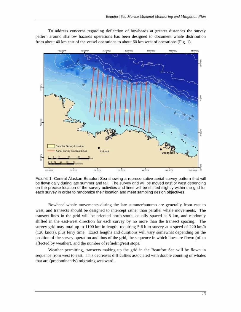
Beaufort Sea Marine Mammal Monitoring and Mitigation Plan
13
To address concerns regarding deflection of bowheads at greater distances the survey pattern around shallow hazards operations has been designed to document whale distribution from about 40 km east of the vessel operations to about 60 km west of operations (Fig. 1).
FIGURE 1. Central Alaskan Beaufort Sea showing a representative aerial survey pattern that will be flown daily during late summer and fall. The survey grid will be moved east or west depending on the precise location of the survey activities and lines will be shifted slightly within the grid for each survey in order to randomize their location and meet sampling design objectives.
Bowhead whale movements during the late summer/autumn are generally from east to west, and transects should be designed to intercept rather than parallel whale movements. The transect lines in the grid will be oriented north-south, equally spaced at 8 km, and randomly shifted in the east-west direction for each survey by no more than the transect spacing. The survey grid may total up to 1100 km in length, requiring 5-6 h to survey at a speed of 220 km/h (120 knots), plus ferry time. Exact lengths and durations will vary somewhat depending on the position of the survey operation and thus of the grid, the sequence in which lines are flown (often affected by weather), and the number of refueling/rest stops.
Weather permitting, transects making up the grid in the Beaufort Sea will be flown in sequence from west to east. This decreases difficulties associated with double counting of whales that are (predominantly) migrating westward.
Beaufort Sea Marine Mammal Monitoring and Mitigation Plan
14
Analysis of Aerial Survey Data During the field program, preliminary maps and summaries of the daily surveys will be
provided to NMFS as normally required by the terms of the IHA. While in the field, data will be checked for entry errors and files will be backed up to CDs or portable memory drives. Two levels of analyses will be conducted at the end of the season. The first level will consist of basic summaries that are required for the 90-day report specified by the IHA. These include summaries of numbers of marine mammals recorded, survey effort by date, maps summarizing sightings, and estimates of numbers of marine mammals that are “taken” according to NMFS criteria. The second level of analyses will be presented in the subsequent comprehensive report. The comprehensive report will provide more detailed analyses of the data to quantify the effect of the survey program on the distribution and movements of marine mammals.
Estimation of Numbers “Taken” Shell has used this methodology, which was developed using past studies in the Beaufort
and Chukchi sea regions (Miller et al. 1999; Haley and Ireland 2006) and other areas of the world (Lawson et al. 1998; Holst et al. 2005; Ireland et al. 2005), for estimating the numbers of marine mammals that are “taken” (as defined by NMFS). “Take” numbers are determined by estimating the numbers of animals present near or passing the survey activities during periods without airgun activity and assuming that similar numbers would have passed during periods when airguns were active. The planned approach has been accepted by NMFS as satisfying the requirements for “take” estimates for previous monitoring programs.
The criteria to be used in tabulating and estimating numbers of cetaceans potentially exposed to various sound levels will be consistent with those used during previous related projects in 1996-2009, unless otherwise directed by NMFS. Only cetaceans will be addressed using the aerial survey data because the altitude of the surveys is too high to reliably detect and identify pinnipeds. As in previous studies, Shell anticipates that there will be four components:
1. Numbers of cetaceans observed within the area ensonified by the survey activities. For cetaceans, Shell will estimate the numbers of animals exposed to received levels of sounds exceeding 120, 160 dB and 180 dB rms re 1 µPa, as required by NMFS.
2. Numbers of cetaceans observed showing apparent reactions to survey activities, e.g., heading in an “atypical” direction. Animals exhibiting apparent responses to the activities will be counted as affected by the programs if they were exposed to sounds from those activities.
3. Numbers of cetaceans estimated to have been subjected to sound levels 160 and 180 dB re 1µ Pa (rms) when no monitoring observations were possible. This will involve using the observations from the survey aircraft, supplemented by relevant vessel-based observations, to estimate how many cetaceans were exposed over the full course of Shell’s 2010 shallow hazards survey program to situations where received sound levels were 160 and 180 dB rms. In the case of bowhead whale, Shell will estimate pro-portions of observed whales that were close enough to shore to have passed through the area where exposure might occur, and could have passed while survey operations were underway. Shell’s aerial survey design, together with the complementary aerial surveys to be conducted by MMS, will provide the needed data.
Beaufort Sea Marine Mammal Monitoring and Mitigation Plan
15
4. The number of bowheads whose migration routes came within 20 km of the survey activity, or would have done so if they had not been displaced farther offshore, will be estimated. If the 2010 data indicate that the avoidance distance exceeds 20 km, the larger avoidance distance will also be used for estimating the numbers of whales potentially responding to the survey activity. These estimates will be obtained by determining the displacement distance based on the aerial survey results, and then estimating how many bowheads were likely to approach the avoided area during times while the survey vessel was active.
Effects of Survey Activities on Bowhead Migration The location of the bowhead migration corridor in 2010 will be determined by examining
data from periods without survey activities and/or from east of the operations. The MMS aerial survey data will be a useful supplement for areas well east of the survey program. Shell will contrast the numbers of bowhead sightings and individuals vs. distance from shore:
during periods with vs. without survey operations, and near vs. east vs. west of the survey areas.
The distance categories will be linked to received sound levels based on the results from the acoustic measurement task. Analyses will be done on a sightings-per-unit effort basis to allow meaningful interpretation even though aerial survey effort is inevitably inconsistent at different distances offshore.
To determine how far east, north and west displacement effects (if any) extend, additional analyses will be conducted on bowhead sightings and survey effort in relation to distance and bearing from the survey vessel during times with and without airgun activity. Shell anticipates applying a logistic or Poisson regression approach to assess the effects of distance and direction from the survey activities on sighting probability of bowhead whales, allowing for the confounding influence of sightability (sea state, ice conditions, etc) and other covariates. Such an approach has been used extensively in analyses of whale and seal distribution in the Beaufort Sea (Manly et al. 2004; Moulton et al. 2005). Other analyses that may be useful to describe the effects of the survey activities on the bowhead migration path, including summaries of headings, behavior and swimming speeds, will be included in the technical report.
The data from the current survey may not provide enough sightings to be able to quantify the effects of Shell’s 2010 activities on the bowhead whale migration path. That could occur if Shell’s operations in the Beaufort Sea during the bowhead whale migration season were limited due to ice or other factors, or if 2010 is a year when weather conditions are poorer than average, which would limit the periods when aerial surveys could be conducted.
The aerial survey data pertaining to other species of marine mammals will also be mapped and analyzed insofar as is useful. However, the main migration corridor of belugas is far offshore, and generally north of the aerial survey area proposed here. Few gray whales and walruses are likely to be seen because of their rarity in the Beaufort Sea area (although gray whales were seen in the area in 1998 (Miller et al. 1999) and small numbers have been seen during several recent surveys by MMS (Treacy 1998, 2000, 2002) and LGL (Patterson et al. 2007). Therefore, the proposed aerial surveys are expected to document the infrequent use of continental shelf waters of the Beaufort Sea by beluga whales, gray whales and walruses, but detailed analyses for these species probably will not be warranted. Seals cannot be surveyed

Beaufort Sea Marine Mammal Monitoring and Mitigation Plan
16
quantitatively during aerial surveys at altitudes 900 to 1500 ft over open water. The aerial surveys will provide only incidental data on the occurrence of bearded and especially ringed seals in the area.
ACOUSTIC MONITORING PLAN
Sound Source Measurements As described above, previous measurements of airguns in the Harrison Bay area were used
to model the distances at which received levels are likely to fall below 160, 180, and 190 dB rms from the planned airgun sources. These modeled distances will be used as temporary safety radii until measurements of the airgun sound source are conducted. The measurements will be made at the beginning of the field season and the measured radii used for the remainder of the survey period.
The objectives of the sound source verification measurements planned for 2010 in the Beaufort Sea will be (1) to measure the distances in the broadside and endfire directions at which broadband received levels reach 190, 180, 170, 160, and 120 dBrms re 1 Pa for the energy source array combinations that may be used during the survey activities. The configurations will include at least the full array and the operation of a single source that will be used during power downs. The measurements of energy source array sounds will be made at the beginning of the survey and the distances to the various radii will be reported as soon as possible after recovery of the equipment. The primary radii of concern will be the 190 and 180 dB safety radii for pinnipeds and cetaceans, respectively, and the 160 dB disturbance radii. In addition to reporting the radii of specific regulatory concern, nominal distances to other sound isopleths down to 120 dBrms
will be reported in increments of 10 dB.
Data will be previewed in the field immediately after download from the ocean bottom hydrophone (OBH) instruments. An initial sound source analysis will be supplied to NMFS and the airgun operators within 120 hours of completion of the measurements, if possible. The report will indicate the distances to sound levels between 190 dBrms re 1 Pa and 120 dBrms re 1 Pa based on fits of empirical transmission loss formulae to data in the endfire and broadside directions. The 120-hour report findings will be based on analysis of measurements from at least three of the OBH systems. A more detailed report including analysis of data from all OBH systems will be issued to NMFS as part of the 90-day report following completion of the acoustic program.
Airgun pressure waveform data from the OBH systems will be analyzed using JASCO’s suite of custom signal processing software that implements the following data processing steps:
Energy source pulses in the OBH recordings are identified using an automated detection algorithm. The algorithm also chooses the 90% energy time window for rms sound level computations.
Waveform data is converted to units of microPascals (μPa) using the calibrated acoustic response of the OBH system. Gains for frequency-dependent hydrophone sensitivity, amplifier and digitizer are applied in this step.
For each pulse, the distance to the airgun array is computed from GPS deployment positions of the OBH systems and the time referenced DGPS navigation logs of the survey vessel.
Beaufort Sea Marine Mammal Monitoring and Mitigation Plan
17
The waveform data are processed to determine flat-weighted peak sound pressure level (PSPL), rms sound pressure level (SPL) and sound exposure level (SEL).
Each energy pulse is Fast Fourier Transformed (FFT) to obtain 1-Hz spectral power levels in 1-second steps.
The spectral power levels are integrated in standard 1/3-octave bands to obtain band sound pressure levels (BSPL) for bands from 10 Hz to 20 kHz. M-weighted SPL’s for each airgun pulse may be computed in this step for species of interest.
The output of the above data processing steps includes listings and graphs of airgun array narrow band and broadband sound levels versus range, and spectrograms of shot waveforms at specified ranges. Of particular importance are the graphs of level versus range that are used to compute representative radii to specific sound level thresholds.
Acoustic Study of Bowhead Deflections Shell plans to deploy arrays of acoustic recorders in the Beaufort Sea in 2010, similar to
those deployed in 2007 and 2008 using DASARs supplied by Greeneridge. These directional acoustic systems permit localization of bowhead whale and other marine mammal vocalizations. The purpose of the array will be to further understand, define, and document sound characteristics and propagation resulting from shallow hazards surveys that may have the potential to cause deflections of bowhead whales from their migratory pathway. Of particular interest will be the east-west extent of deflection, if any (i.e., how far east of a sound source do bowheads begin to deflect and how far to the west beyond the sound source does deflection persist). Of additional interest will be the extent of offshore (or towards shore) deflection that might occur.
In previous work around seismic operations in the Alaskan Beaufort Sea, the primary method for studying this question has been aerial surveys. Acoustic localization methods will provide supplementary information for addressing the whale deflection question. Compared to aerial surveys, acoustic methods have the advantage of providing a vastly larger number of whale detections, and can operate day and night, independent of visibility, and to some degree independent of ice conditions and sea state—all of which prevent or impair aerial surveys. However, acoustic methods depend on the animals to call, and to some extent assume that calling rate is unaffected by exposure to industrial noise. Bowheads call frequently in fall, but there is some evidence that their calling rate may be reduced upon exposure to industrial sounds, complicating interpretation. The combined use of acoustic and aerial survey methods will provide a suite of information that should be useful in assessing the potential effects of survey operations on migrating bowhead whales.
Objective The objective of this study is to provide information on bowhead migration paths along
the Alaskan coast, particularly with respect to industrial operations, and whether and to what extent there is deflection due to industrial sound levels. Using passive acoustics with directional autonomous recorders, the locations of calling whales will be observed for a six- to ten-week continuous monitoring period at five coastal sites (subject to favorable ice and weather conditions). An example of the whale call locations measured from a similar array of DASARs in 2008 is presented in Figure 2 (Blackwell et al. 2009).
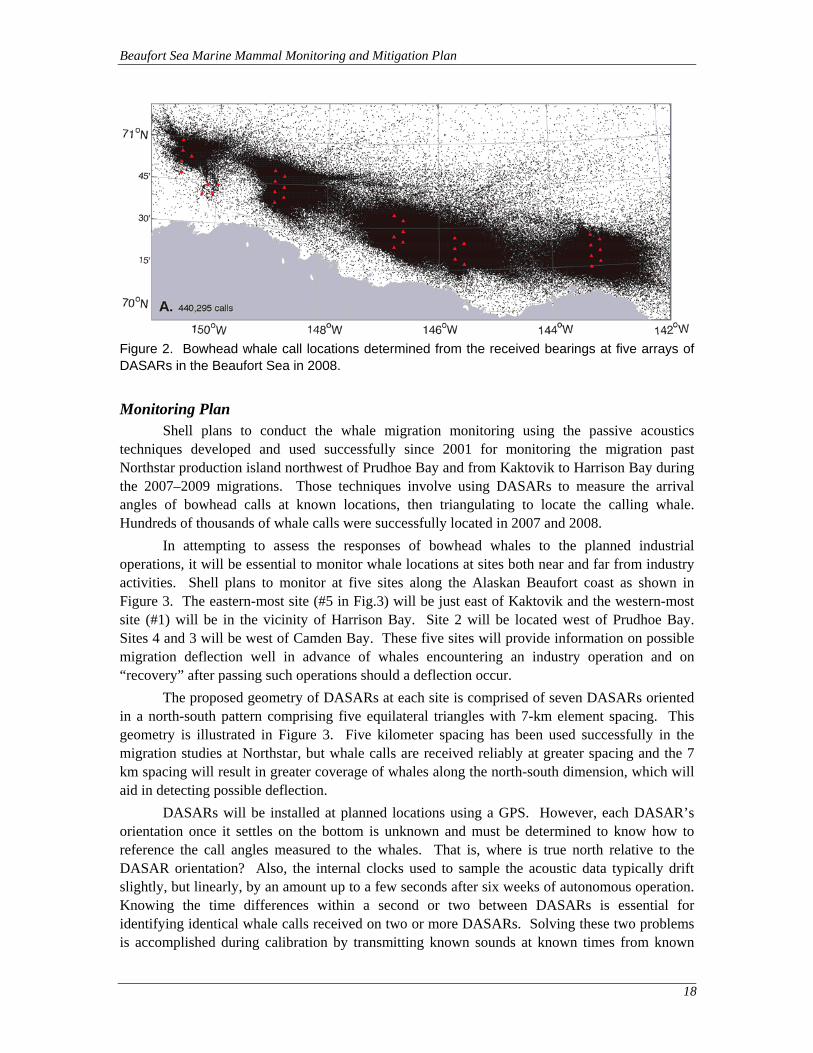
Beaufort Sea Marine Mammal Monitoring and Mitigation Plan
18
Figure 2. Bowhead whale call locations determined from the received bearings at five arrays of DASARs in the Beaufort Sea in 2008.
Monitoring Plan Shell plans to conduct the whale migration monitoring using the passive acoustics
techniques developed and used successfully since 2001 for monitoring the migration past Northstar production island northwest of Prudhoe Bay and from Kaktovik to Harrison Bay during the 2007–2009 migrations. Those techniques involve using DASARs to measure the arrival angles of bowhead calls at known locations, then triangulating to locate the calling whale. Hundreds of thousands of whale calls were successfully located in 2007 and 2008.
In attempting to assess the responses of bowhead whales to the planned industrial operations, it will be essential to monitor whale locations at sites both near and far from industry activities. Shell plans to monitor at five sites along the Alaskan Beaufort coast as shown in Figure 3. The eastern-most site (#5 in Fig.3) will be just east of Kaktovik and the western-most site (#1) will be in the vicinity of Harrison Bay. Site 2 will be located west of Prudhoe Bay. Sites 4 and 3 will be west of Camden Bay. These five sites will provide information on possible migration deflection well in advance of whales encountering an industry operation and on “recovery” after passing such operations should a deflection occur.
The proposed geometry of DASARs at each site is comprised of seven DASARs oriented in a north-south pattern comprising five equilateral triangles with 7-km element spacing. This geometry is illustrated in Figure 3. Five kilometer spacing has been used successfully in the migration studies at Northstar, but whale calls are received reliably at greater spacing and the 7 km spacing will result in greater coverage of whales along the north-south dimension, which will aid in detecting possible deflection.
DASARs will be installed at planned locations using a GPS. However, each DASAR’s orientation once it settles on the bottom is unknown and must be determined to know how to reference the call angles measured to the whales. That is, where is true north relative to the DASAR orientation? Also, the internal clocks used to sample the acoustic data typically drift slightly, but linearly, by an amount up to a few seconds after six weeks of autonomous operation. Knowing the time differences within a second or two between DASARs is essential for identifying identical whale calls received on two or more DASARs. Solving these two problems is accomplished during calibration by transmitting known sounds at known times from known
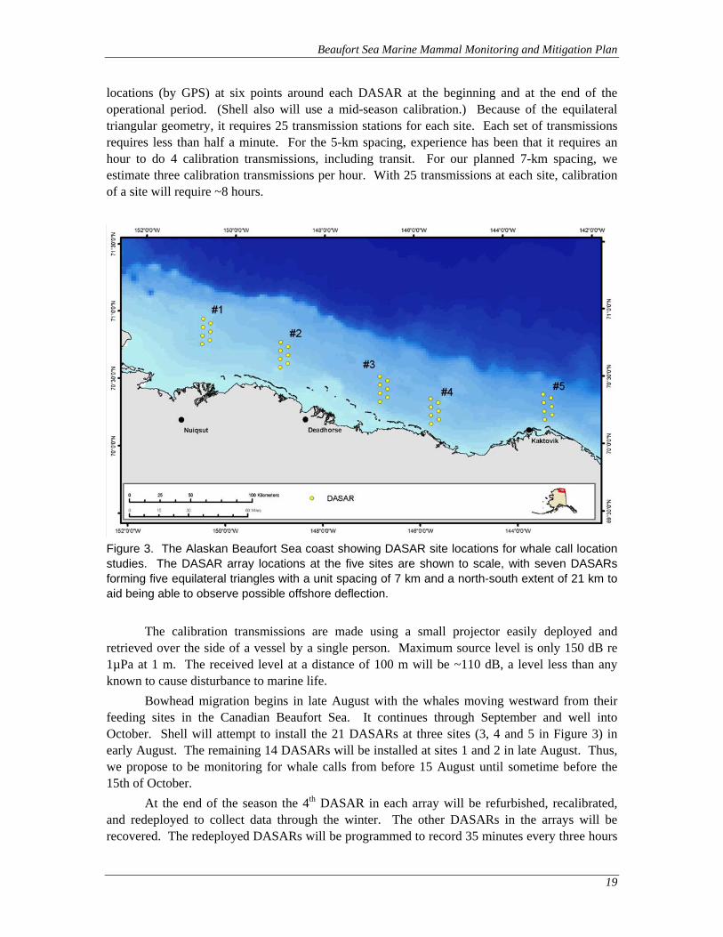
Beaufort Sea Marine Mammal Monitoring and Mitigation Plan
19
locations (by GPS) at six points around each DASAR at the beginning and at the end of the operational period. (Shell also will use a mid-season calibration.) Because of the equilateral triangular geometry, it requires 25 transmission stations for each site. Each set of transmissions requires less than half a minute. For the 5-km spacing, experience has been that it requires an hour to do 4 calibration transmissions, including transit. For our planned 7-km spacing, we estimate three calibration transmissions per hour. With 25 transmissions at each site, calibration of a site will require ~8 hours.
Figure 3. The Alaskan Beaufort Sea coast showing DASAR site locations for whale call location studies. The DASAR array locations at the five sites are shown to scale, with seven DASARs forming five equilateral triangles with a unit spacing of 7 km and a north-south extent of 21 km to aid being able to observe possible offshore deflection.
The calibration transmissions are made using a small projector easily deployed and retrieved over the side of a vessel by a single person. Maximum source level is only 150 dB re 1µPa at 1 m. The received level at a distance of 100 m will be ~110 dB, a level less than any known to cause disturbance to marine life.
Bowhead migration begins in late August with the whales moving westward from their feeding sites in the Canadian Beaufort Sea. It continues through September and well into October. Shell will attempt to install the 21 DASARs at three sites (3, 4 and 5 in Figure 3) in early August. The remaining 14 DASARs will be installed at sites 1 and 2 in late August. Thus, we propose to be monitoring for whale calls from before 15 August until sometime before the 15th of October.
At the end of the season the 4th DASAR in each array will be refurbished, recalibrated, and redeployed to collect data through the winter. The other DASARs in the arrays will be recovered. The redeployed DASARs will be programmed to record 35 minutes every three hours
Beaufort Sea Marine Mammal Monitoring and Mitigation Plan
20
with a disk capacity of 10 months at that recording rate. This should be ample space to allow over-wintering from ~mid-October 2010 through mid-July 2011.
Whale call analysis for the Northstar DASARs has been a manual process in which analysts observe acoustic spectrograms in one-minute periods, looking for patterns caused by a whale call. Listening to the sound, the analyst verifies that a sound is or is not a whale call. The bearing is calculated for whale calls and stored for localization if the same call is present at one or more other DASARs in an array. In the proposed 2010 project, machine-aided call detection software will be used to simplify and accelerate the call analysis. Such software was developed with Shell’s sponsorship in 2006 and is described in Greene et al. (2007). The software has been tested during data collection efforts in 2008 and is currently undergoing additional tests to determine its ability to accurately locate whale calls.
When the call locations have been assessed for accuracy, the locations will be analyzed for evidence of migration deflection. However, one must assess where the migration path would have been in the absence of industrial activities. The migration path is known to vary from year to year as a consequence of various factors. To control for this inter-annual variation, array pairs east and west of industrial activities will be used to compare offshore distances prior to and after whales pass through areas exposed to varying levels of anthropogenic sound. All DASAR arrays, and potentially those deployed for other studies (i.e., those supporting BP’s studies of migration past its Northstar development), could be used to quantify density contours of the bowhead whale migration corridor. This estimation of the migration corridor would amount to an unprecedented quantification in terms of the extent of the coastline covered and the amount of data included.
Many interesting analyses will be available from the data collected by the five array sites. Only two analyses are discussed here.
One analysis will estimate the location of the migration corridor across the extent of our study area. The migration corridor will be estimated by contours for the distribution of whale locations along the coast from array #1 to array #5. Density contours will be estimated using kernel density estimation (Silverman 1998). To be included in this analysis, call precision must be high, or alternatively, calls will be inversely weighted according to the size of their error ellipse. Because Shell anticipates that calls occurring between arrays will have very low precision, the variance of density estimates in these areas will be high. If the migration corridor is generally close to shore at arrays #5 and #4, but far offshore at the locations of arrays #2, and #1, an offshore displacement of the corridor near the planned survey activity might be inferred. Shell plans to use block bootstrapping (Lahiri 2003) of raw data to assess variation in contours when appropriate. Block bootstrapping accounts for potential autocorrelation among locations collected during short time intervals. This analysis does not depend on quantification of underwater industrial sounds emanating from survey operations.
A second analysis to assess deflection will relate changes in offshore distribution to changes in industrial sound levels. These analyses are predicated on the assumption that industrial sound levels will vary from below background to substantially above background throughout the season, and that reliable measurements of industrial sound at the source are available. Assuming source levels vary substantially throughout the season, this analysis will use periods of low industrial sound as “reference” periods, and relate shifts in the offshore distribution to increased levels of sound using regression or quantile regression analysis (Koenker and Park 1996; Koenker and Geling 2001; Koenker and Xiao 2002).
Beaufort Sea Marine Mammal Monitoring and Mitigation Plan
21
To illustrate the second analysis, consider DASAR sites #1 and #2 in Figure 3. Over a standard reporting period, for example 6 hours, calls located by these two arrays will be collected, as well as other environmental covariates such as water depth, ambient sound levels, time of day, etc. From these data, summary statistics for offshore distribution, and all covariates of interest will be calculated. For example, the 25th percentile of offshore distance may be calculated, as well as the average water depth of all call locations in the 6-hour reporting period. Differences in offshore summary statistics among arrays will then be calculated and used in a regression or quantile regression analysis. Using the example above, the difference in 25th percentile of offshore distance between array #1 and array #2 could be related to the average industrial sound level output by the source. Assuming displacement occurs somewhere between arrays #1 and #2, a constant difference in the 25th percentile of offshore distance when sound levels are low, and larger differences in offshore distance when industrial sound levels increase would be expected. A significant slope of the regression relating offshore distance difference to sound levels will indicate a statistically significant displacement between the arrays in question. This type of analysis can be run using any pair of DASAR arrays (e.g., between #5 and #3 or between #4 and #1, etc.).
Analysis assumptions:
Changes in the offshore distribution of call locations reflect either changes in whale locations or changes in calling behavior.
Industrial sound levels will vary substantially throughout the season. “Substantial” means by a level that is both detectable and biologically important to bowhead whales. In other words, extended periods of both low and high sound production need to be present.
Industrial sound levels surrounding the airgun sources need to be accurately quantified at varying distances in such a way that industrial sound levels and whale locations can be matched. An accurate propagation model for industrial sounds hopefully can be constructed from the collected data.
A large number of whales will swim through the areas where arrays can reliably locate their calls.
Analysis Report Analysis of all acoustic data will be prioritized to address the primary questions. The
primary data analysis questions are to (a) determine when, where, and what species of animals are acoustically detected on each DASAR, (b) analyze data as a whole to determine offshore bowhead distributions as a function of time, (c) quantify spatial and temporal variability in the ambient noise, and (d) measure received levels of airgun activities. The bowhead detection data will be used to develop spatial and temporal animal distributions. Statistical analyses will be used to test for changes in animal detections and distributions as a function of different variables (e.g., time of day, time of season, environmental conditions, ambient noise, vessel type, operation conditions).
Beaufort Sea Marine Mammal Monitoring and Mitigation Plan
22
COMPREHENSIVE REPORT ON INDUSTRY ACTIVITIES AND MARINE MAMMAL MONITORING EFFORTS IN THE BEAUFORT AND CHUKCHI SEAS
Following the 2010 shallow hazards surveys a comprehensive report describing the vessel-based, aerial, and acoustic monitoring programs will be prepared. The comprehensive report will describe the methods, results, conclusions and limitations of each of the individual data sets in detail. The report will also integrate (to the extent possible) the studies into a broad based assessment of industry activities, and other activities that occur in the Beaufort and/or Chukchi seas, and their impacts on marine mammals during 2010. The report will help to establish long-term data sets that can assist with the evaluation of changes in the Chukchi and Beaufort sea ecosystems. The report will attempt to provide a regional synthesis of available data on industry activity in offshore areas of northern Alaska that may influence marine mammal density, distribution and behavior.

Beaufort Sea Marine Mammal Monitoring and Mitigation Plan
23
LITERATURE CITED
ADFG (Alaska Department of Fish and Game). 2009. Satellite Tracking of Western Arctic Bowhead Whales. Preliminary reports and summaries available at:
http://www.wildlife.alaska.gov/index.cfm?adfg=marinemammals.bowhead
Blackwell, S.B., C.R. Greene, H.K. Kim, T.L. McDonald, C.S. Nations, R.G. Norman, and A. Thode. 2009. Beaufort Sea acoustic monitoring program. (Chapter 9) In: Funk, D. W., D. S. Ireland, R. Rodrigues, and W. R. Koski (eds.). 2009. Joint Monitoring Program in the Chukchi and Beaufort Seas, Open Water Seasons 2006–2008. LGL Alaska Rep. P1050-1. Rep. from LGL Alaska Research Associates Inc., Anchorage, AK, LGL Ltd., JASCO Research Ltd. and Greeneridge Sciences, Inc. for Shell Offshore Inc, Houston, TX, ConocoPhillips Alaska Inc., Anchorage, AK and Nat. Mar. Fish. Serv., Silver Spring, MD. and U.S. Fish and Wildlife Service. 488 p. plus appendices.
Brewer, K.D., M.L. Gallagher, P.R. Regos, P.E. Isert, and J.D. Hall. 1993. Kuvlum #1 exploration prospect final report – site specific monitoring program. Report from Coastal & Offshore Pacific Corporation, Walnut Creek, CA, for ARCO Alaska. Inc.
Clarke, J.T., S.E. Moore and M.M. Johnson. 1993. Observations on beluga fall migration in the Alaskan Beaufort Sea, 1982-87, and northeastern Chukchi Sea, 1982-91. Rep. Int. Whal. Comm. 43:387-396.
COMIDA. 2009. Chukchi Offshore Monitoring in Drilling Area. National Marine Mammal Laboratory Cetacean Assessment and Ecology Program, Bowhead Whale Aerial Surveys: Preliminary Data. Available at: http://www.afsc.noaa.gov/nmml/cetacean/bwasp/index.php
Davies, J.R. 1997. The impact of an offshore drilling platform on the fall migration path of bowhead whales: a GIS-based assessment. Unpubl. M.Sc. Thesis. Western Washington University. 52 p.
Davis, R.A., W.R. Koski, W.J. Richardson, C.R. Evans and W.G. Alliston. 1982. Distribution, numbers and productivity of the Western Arctic stock of bowhead whales (Balaena mysticetus) in the eastern Beaufort Sea and Amundsen Gulf, summer 1981. SC/34/PS20. Int. Whal. Comm., Cambridge, UK. 13 p.
Davis, R.A., C.R. Greene and P.L. McLaren. 1985. Studies of the potential for drilling activities on Seal Island to influence fall migration of bowhead whales through Alaskan nearshore waters. Rep. from LGL Ltd., King City, Ont., for Shell Western E & P Inc., Anchorage, AK. 70 p.
Evans, C.R., S.R. Johnson and W.R. Koski. 1987. Responses of bowhead whales to an offshore drilling operation in the Alaskan Beaufort Sea, autumn 1986: Aerial surveys of whale distribution. Rep. by LGL Ltd., King City, Ontario, for Shell Western E& P Inc., Anchorage. 69 p.
Funk, D. W., D. S. Ireland, R. Rodrigues, and W. R. Koski (eds.). 2009. Joint Monitoring Program in the Chukchi and Beaufort Seas, Open Water Seasons 2006–2008. LGL Alaska Rep. P1050-1. Rep. from LGL Alaska Research Associates Inc., Anchorage, AK, LGL Ltd., JASCO Research Ltd. and Greeneridge Sciences, Inc. for Shell Offshore Inc, Houston, TX, ConocoPhillips Alaska Inc., Anchorage, AK and Nat. Mar. Fish. Serv., Silver Spring, MD. and U.S. Fish and Wildlife Service. 488 p. plus appendices.
Greene, C.R. 1987. Characteristics of oil industry dredge and drilling sounds in the Beaufort Sea. J. Acoust. Soc. Am. 82(4):1315-1324.
Greene, C.R. Jr., R.G. Norman, S.B. Blackwell, M.W. McLennan, and A. Thode. 2007. Acoustics research for studying bowhead migration, 2006. Technical report for Shell Offshore International, Houston, Texas, by Greeneridge Sciences Inc., Santa Barbara, California, and LGL Alaska environmental research associates Inc., Anchorage, Alaska. 24 p.
Beaufort Sea Marine Mammal Monitoring and Mitigation Plan
24
Haley, B. and D. Ireland. 2006. Marine mammal monitoring during University of Alaska Fairbank’s marine geophysical survey across the Arctic Ocean, August-September 2005. LGL report 4122-3. Report from LGL Alaska Research Associates, Anchorage, AK and LGL Ltd, King City, Ont., for Geophysical Institute, University of Alaska, Fairbanks, AK, and Nat. Mar. Fish. Serv., Silver Spring, MD. 80 p.
Hall, J.D., M.L. Gallagher, K.D. Brewer, P.R. Regos and P.E. Isert. 1994. 1993 Kuvlum exploration area site specific monitoring program – final report. Report from Coastal & Offshore Pacific Corporation, Walnut Creek, CA, for ARCO Alaska, Inc.
Harris, R.E., G.W. Miller, R.E. Elliott and W.J. Richardson. 1997. Seals [1996]. p. 4-1 to 4-42 In: W.J. Richardson (ed.), Northstar marine mammal monitoring program, 1996: marine mammal and acoustical monitoring of a seismic program in the Alaskan Beaufort Sea. LGL Rep. 2121-2. Rep. from LGL Ltd., King City, Ont., and Greeneridge Sciences Inc., Santa Barbara, CA, for BP Explor. (Alaska) Inc., Anchorage, AK, and Nat. Mar. Fish. Serv., Anchorage, AK, and Silver Spring, MD. 245 p.
Harris, R.E., A.N. Balla-Holden, S.A. MacLean and W.J. Richardson. 1998. Seals [1997]. p. 4-1 to 4-54 In: W.J. Richardson (ed.), Marine mammal and acoustical monitoring of BP Exploration (Alaska's) open-water seismic program in the Alaskan Beaufort Sea, 1997. LGL Rep. TA2150-3. Rep. from LGL Ltd., King City, Ont., and Greeneridge Sciences Inc., Santa Barbara, CA, for BP Explor. (Alaska) Inc., Anchorage, AK, and U.S. Nat. Mar. Fish. Serv., Anchorage, AK, and Silver Spring, MD. 318 p.
Holst, M., M.A. Smultea,. W.R. Koski, and B. Haley. 2005. Marine mammal and sea turtle monitoring during Lamont-Doherty Earth Observatory’s marine seismic program off the Northern Yucatán Peninsula in the Gulf of Mexico, January–February 2004. LGL Rep. TA2822 31. Rep. from LGL Ltd., King City, Ont., for Lamont-Doherty Earth Observatory of Columbia Univ., Palisades, NY, and Nat. Mar. Fish. Serv., Silver Spring, MD. 96 p.
Ireland, D., M. Holst, and W.R. Koski. 2005. Marine mammal monitoring during Lamont-Doherty Earth
Observatory’s seismic program off the Aleutian Islands, Alaska, July–August 2005. LGL Rep. TA2822-32. Rep. from LGL Ltd., King City, Ont., for Lamont-Doherty Earth Observatory of Columbia Univ., Palisades, NY, and Nat. Mar. Fish. Serv., Silver Spring, MD. 67 p.
Ireland D. S., D. W. Funk, R. Rodrigues, and W. R. Koski (eds.). 2008. Joint Monitoring Program in the Chukchi and Beaufort Seas, July-November 2007. LGL Alaska Rep. P971-1. Rep. from LGL Alaska Research Associates Inc., Anchorage, AK, LGL Ltd., and JASCO Research Ltd. and Greeneridge Sciences, Inc. for Shell Offshore Inc, Houston, TX, ConocoPhillips Alaska Inc., Anchorage, AK and Nat. Mar. Fish. Serv., Silver Spring, MD. and U.S. Fish and Wildlife Service. 445 p. plus appendices.
Ireland, D.S., R. Rodrigues, D. Funk, W.R. Koski, D. Hannay. (eds.). 2009. Marine mammal monitoring and mitigation during open water seismic exploration by Shell Offshore Inc. In the Chukchi and Beaufort Seas, July–October 2008 : 90-day report. LGL Rep. P1049-1. Rep from LGL Alaska Research Associates Inc., LGL Ltd., and JASCO Research Ltd. For Shell Offshore Inc., Nat. Mar. Fish. Serv., and U.S. Fish and Wild. Serv. 277 pp, plus appendices.
Johnson, S.R., C.R. Greene, R.A. Davis and W.J. Richardson. 1986. Bowhead whales and underwater noise near the Sandpiper Island drillsite, Alaskan Beaufort Sea, autumn 1985. Rep. from LGL Ltd., King City, Ont., for Shell Western E & P Inc., Anchorage, AK. 130 p.
Koenker, R. and Geling, O. (2001) Reappraising medfly longevity: a quantile regression survival analysis. Journal of the American Statistical Association, 95, p. 458-468.
Koenker, R. and Park, B. J. (1996) An interior point algorithm for nonlinear quantile regression. Journal of Econometrics, 71, p. 265-283.

Beaufort Sea Marine Mammal Monitoring and Mitigation Plan
25
Koenker, R. and Xiao, Z. (2002) Inference on the quantile regression process. Econometrica, 70, p. 1583-1612.
Koski, W. R. and S. R. Johnson. 1987. Behavioral studies and aerial photogrammetry. Section 4. In Responses of bowhead whales to an offshore drilling operation in the Alaskan Beaufort Sea, autumn 1986. Report from LGL Ltd., King City, Ontario, and Greeneridge Sciences Inc., Santa Barbara, CA, for Shell Western Exploration and Production Inc., Anchorage, AK.
Koski, W.R., Thomas, T.A., G.W. Miller, R.A. Davis and W.J. Richardson. 2002. Residence times and rates of movement of bowhead whales in the Beaufort Sea and Amundsen Gulf during summer and autumn. Chapter 11. In: W.J. Richardson and D.H. Thomson (eds). Bowhead whale feeding in the eastern Alaskan Beaufort Sea: Final Report. Report by LGL Ltd., King City, for Minerals Management Service, Anchorage, AK.
Landino, S.W., S.D. Treacy, S.A. Zerwick and J.B. Dunlap. 1994. A Large aggregation of bowhead whales (Balaena mysticetus) feeding near Barrow, Alaska, in late Oct. 1992. Arctic 47(3):232-235.
Lawson, J.W., W.R. Koski, D.H. Thomson and W.J. Richardson. 1998. Chapter 4.7 Marine Mammals: Environmental Consequences. In: Environmental Impact Statement/Overseas Environmental Impact Statement Point Mugu Sea Range. Prepared by LGL Limited, King City, Ontario, and Ogden Environmental and Energy Services, Santa Barbara, CA, for Dep. Navy, Naval Air Warfare Center Weapons Division, Point Mugu, Ca and Southwest Division Naval Facilities Engineering Command, San Diego, CA.
Ljungblad, D.K., S.E. Moore and J.T. Clarke. 1986a. Assessment of bowhead whale (Balaena mysticetus) feeding patterns in the Alaskan Beaufort and northeastern Chukchi seas via aerial surveys, fall 1979-84. Rep. Int. Whal. Comm. 36:265-272.
Ljungblad, D.K., S.E. Moore, J.T. Clarke and J.C. Bennett. 1986b. Aerial Surveys of Endangered Whales in the Northern Bering, Eastern Chukchi, and Alaskan Beaufort Seas, 1985: With a Seven Year Review, 1979-85. OCS Study, MMS 86-0002. Anchorage, AK: USDOI, MMS, Alaska OCS Region, 142 p.
Lowry, L.F. 1993. Foods and feeding ecology. p. 201-238 In: J.J. Burns, J.J. Montague and C.J. Cowles (eds) The Bowhead Whale. Special Publication. No. 2. Society for Marine Mammalogy, Lawrence, Kansas. 787 p.
Lowry, L.F., G. Sheffield, and J.C. George. 2004. Bowhead whale feeding in the Alaskan Beaufort Sea based on stomach contents analyses. J. Cetacean Res. Manage. 63: 223.
Manly, B.F.J., V.D. Moulton, R.E. Elliott, G.W. Miller and W.J. Richardson. 2004. Analysis of covariance of fall migrations of bowhead whales in relation to human activities and environmental factors, Alaskan Beaufort Sea: Phase I, 1996-1998. Report by LGL Limited, King City, ON, and WEST Inc, Cheyenne, WY, for Minerals Management Service, Herndon, VA and Anchorage, AK. 128 p.
Miles, P.R., C.I. Malme and W.J. Richardson. 1987. Prediction of drilling site-specific interaction of industrial acoustic stimuli and endangered whales in the Alaskan Beaufort Sea. BBN Rep. 6509; OCS Study MMS 87-0084. Rep. from BBN Labs Inc., Cambridge, MA, and LGL Ltd., King City, Ont., for U.S. Minerals Manage. Serv., Anchorage, AK. 341 p. NTIS PB88-158498.
Miller, G.W., R.E. Elliott, W.R. Koski and W.J. Richardson. 1997. Whales. p. 5-1 to 5-115 In: W.J. Richardson (ed.), Northstar marine mammal monitoring program, 1996: marine mammal and acoustical monitoring of a seismic program in the Alaskan Beaufort Sea. LGL Rep. 2121-2. Rep. from LGL Ltd., King City, ON and Greeneridge Sciences Inc., Santa Barbara, CA, for BP Explor. (Alaska) Inc. and Nat. Mar. Fish. Serv., Anchorage, AK, and Silver Spring, MD. 245 p.
Miller, G.W., R.E. Elliott and W.J. Richardson. 1998. Whales. p 5-1 to 5-123 In: W.J. Richardson (ed.), Northstar marine mammal monitoring program, 1997: marine mammal and acoustical monitoring of a seismic program in the Alaskan Beaufort Sea. LGL Rep. 2150-3. Rep. from LGL Ltd., King
Beaufort Sea Marine Mammal Monitoring and Mitigation Plan
26
City, ON and Greeneridge Sciences Inc., Santa Barbara, CA, for BP Explor. (Alaska) Inc. and Nat. Mar. Fish. Serv., Anchorage, AK, and Silver Spring, MD. 318 p.
Miller, G.W., R.E. Elliott, W.R. Koski, V.D. Moulton, and W.J. Richardson. 1999. Whales. p. 5-1 to 5-109 In: W.J. Richardson (ed.), Marine mammal and acoustical monitoring of Western Geophysical's open-water seismic program in the Alaskan Beaufort Sea, 1998. LGL Rep. TA2230-3. Rep. from LGL Ltd., King City, Ont., and Greeneridge Sciences Inc., Santa Barbara, CA, for Western Geophysical, Houston, TX, and U.S. Nat. Mar. Fish. Serv., Anchorage, AK, and Silver Spring, MD. 390 p.
Miller, G.W., R.E. Elliott, T.A. Thomas, V.D. Moulton and W.R. Koski. 2002. Distribution and numbers of bowhead whales in the eastern Alaskan Beaufort Sea during late summer and autumn, 1979-2000. p. 9-1 to 9-39 (Chap. 9) In: W.J. Richardson and D.H. Thomson (eds.), Bowhead whale feeding in the eastern Alaskan Beaufort Sea: update of scientific and traditional information, vol. 1. OCS Study MMS 2002-012; LGL Rep. TA2196-7. Rep. from LGL Ltd., King City, Ont., for U.S. Minerals Manage. Serv., Anchorage, AK, and Herndon, VA. 420 p. NTIS PB2006-100382.
Monnett, C. and S.D. Treacy. 2005. Aerial surveys of endangered whales in the Beaufort Sea, fall 2002-2004. U.S. Minerals Manage. Serv., Anchorage, AK. 153 p.
Moore, S.E., J.T. Clarke and M.M. Johnson. 1993. Beluga distribution and movements offshore northern Alaska in spring and summer, 1980-84. Rep. Int. Whal. Comm. 43:375-86.
Moulton, V.D. and J.W. Lawson. 2002. Seals, 2001. p. 3-1 to 3-48 In: W.J. Richardson (ed.), Marine mammal and acoustical monitoring of WesternGeco’s open water seismic program in the Alaskan Beaufort Sea, 2001. Rep. from LGL Ltd., King City, Ont., and Greeneridge Sciences Inc., Santa Barbara, CA, for WesternGeco, Houston, TX, and Nat. Mar. Fish. Serv., Anchorage, AK, and Silver Spring, MD. LGL Rep. TA2564-4.
Moulton, V.D., W.J. Richardson, R.E. Elliott, T.L. McDonald, C. Nations and M.T. Williams. 2005. Effects of an offshore oil development on local abundance and distribution of ringed seals (Phoca hispida) of the Alaskan Beaufort Sea. Mar. Mamm. Sci. 21(2):217-242.
NMFS. 2000. Small takes of marine mammals incidental to specified activities; marine seismic-reflection data collection in southern California/Notice of receipt of application. Fed. Regist. 65(60, 28 Mar.):16374-16379.
Patterson, H., S.B. Blackwell, B. Haley, A. Hunter, M. Jankowski, R. Rodrigues, D. Ireland and D. W. Funk. 2007. Marine mammal monitoring and mitigation during open water seismic exploration by Shell Offshore Inc. in the Chukchi and Beaufort Seas, July–September 2006: 90-day report. LGL Draft Rep. P891-1. Rep. from LGL Alaska Research Associates Inc., Anchorage, AK, LGL Ltd., King City, Ont., and Greeneridge Sciences Inc., Goleta, CA, for Shell Offshore Inc, Houston, TX, and Nat. Mar. Fish. Serv., Silver Spring, MD. 119 p.
Richardson, W.J., C.R. Greene, Jr., C.I. Malme, and D.H. Thomson. 1995. Marine Mammals and Noise. Academic Press, San Diego, CA.
Silverman, B.W. 1998. Density estimation for statistics and data analysis. Chapman & Hall/CRC, Boca Raton.
Thomas, T.A., Koski, W.R. and Richardson, W.J. 2002. Correction factors to calculate bowhead whale numbers form aerial surveys of the Beaufort Sea. Chapter 15. In: W.J. Richardson and D.H. Thomson (eds.). Bowhead whale feeding in the eastern Alaskan Beaufort Sea: Update of Scientific and Traditional Information. 28pp. OCS Study MMS 2002-012.
Treacy, S.D. 1998. Aerial surveys of endangered whales in the Beaufort Sea, fall 1997. OCS Study MMS 98-059. U.S. Minerals Manage. Serv., Anchorage, AK. 143 p.
Treacy, S.D. 2000. Aerial surveys of endangered whales in the Beaufort Sea, fall 1998-1999. OCS Study MMS 2000-066. U.S. Minerals Manage. Serv., Anchorage, AK. 135 p.

Beaufort Sea Marine Mammal Monitoring and Mitigation Plan
27
Treacy, S.D. 2002. Aerial surveys of endangered whales in the Beaufort Sea, fall 2000. OCS Study MMS 2002-014. U.S. Minerals Manage. Serv., Anchorage, AK. 111 p.
Würsig, B., W.R. Koski, T.A. Thomas and W.J. Richardson. 2002. Activities and behavior of bowhead whales in the eastern Alaskan Beaufort Sea during late summer and autumn. Chapter 12. In: W.J. Richardson and D.H. Thomson (eds). Bowhead whale feeding in the eastern Alaskan Beaufort Sea: Final Report. Report by LGL Ltd., King City, for Minerals Management Service, Anchorage, AK.