Sgurr Energy Ltd Linfairn Wind Farm Appendix 9.4 ... Dependent Terrestrial Ecosystems Risk...
26
This Document is of UK Origin Sgurr Energy Ltd Linfairn Wind Farm Appendix 9.4 Groundwater Dependent Terrestrial Ecosystems Risk Assessment September 2013
Transcript of Sgurr Energy Ltd Linfairn Wind Farm Appendix 9.4 ... Dependent Terrestrial Ecosystems Risk...

This Document is of UK Origin
Sgurr Energy Ltd
Linfairn Wind Farm
Appendix 9.4
Groundwater Dependent Terrestrial Ecosystems Risk
Assessment
September 2013

This Document is of UK Origin
EnviroCentre Document No. 5631
EnviroCentre Project No. 161766j
Status Final
Project Manager Hannah Barker
Project Reviewer Lucila Lantschner
Date of Issue September 2013
Filename linfairn_gwdte_final_reva.docx
EnviroCentre
Craighall Business Park
Eagle Street
Glasgow
G4 9XA
t 0141 341 5040
f 0141 341 5045
w www.envirocentre.co.uk
Offices
Glasgow
Banchory
This document has been prepared for the Client named on this front cover. EnviroCentre accept no liability or responsibility for any
use that is made of this document other than by the Client for the purpose of the original commission for which it has been prepared.

Sgurr Energy September 2013
Linfairn Wind Farm: GWDTE Risk Assessment
i
Linfairn Wind Farm
Groundwater Dependent Terrestrial Ecosystem Risk Assessment
Table of Contents
1. Introduction ................................................................................................................................. 2
1.1 Terms of Reference ............................................................................................................................................. 2 1.2 The Site ................................................................................................................................................................ 2 1.3 Methodology ....................................................................................................................................................... 2
2. Qualitative Assessment ............................................................................................................... 3
2.1 Site Hydrogeology ............................................................................................................................................... 3 2.2 GWDTE Identification ......................................................................................................................................... 3 2.3 Nearby Site Infrastructure .................................................................................................................................. 5 2.4 Qualitative Risk Assessment ............................................................................................................................... 5
3. Mitigation Measures ................................................................................................................. 23
Figures (Volume 3 of ES):
Figure 9.13a GWDTEs and Flow Directions (1 of 2)
Figure 9.13b GWDTEs and Flow Directions (2 of 2)
List of Tables
Table 2.1: GWDTEs at the site ................................................................................................................................................. 4
Table 2.2: GWDTE sensitivity ................................................................................................................................................... 4
Table 2.3: Risk Assessment Matrix .......................................................................................................................................... 6

Sgurr Energy September 2013
Linfairn Wind Farm: GWDTE Risk Assessment
2
1. INTRODUCTION
1.1 Terms of Reference
EnviroCentre Ltd has been commissioned by Sgurr Energy to carry out a Water and Soils assessment for the proposed
Linfairn Wind Farm, located near to Straiton, South Ayrshire. This report forms a Technical Appendix to Chapter 8
(Water Environment & Soils) of the Environmental Statement (ES) for Linfairn Wind Farm and should be read with
reference to this chapter.
The National Vegetation Classification (NVC) survey undertaken for the site identified areas of Groundwater
Dependent Terrestrial Ecosystems (GWDTEs) in the buffer zones defined by the current SEPA guidance1 (referred to as
the SEPA guidance within this report). This report details the qualitative assessment which has been undertaken to
identify any risks of the development on these GWDTEs and outlines suitable mitigation measures.
1.2 The Site
The proposed wind farm development consists of 25 WTGs and associated hardstandings, access tracks, two site
compounds and a sub-station building. There are no borrow pits proposed at the site. Access to the proposed site will
be from minor road situated to the north of the site. The site includes a variety of lowland and upland habitats ranging
from blanket bog to improved pasture. The majority of the site is currently used for grazing, with commercial forest
plantation present in the north-eastern part of the site.
1.3 Methodology
The following methodology was used for the GWDTE assessment:
• Identification of GWDTE on the site;
• Identification of site infrastructure located within buffer zones of GWDTE;
• Analysis of relevant hydrogeological conditions for each GWDTE;
• Qualitative assessment of the risks to each GWDTE from site infrastructure;
• Identification of mitigation measures to minimise any risks to GWDTEs; and
• Report summarising the findings of the assessment.
1 SEPA. 2012. LUPS Guidance Note 4: Planning guidance on windfarm developments. Version 6.

Sgurr Energy September 2013
Linfairn Wind Farm: GWDTE Risk Assessment
3
2. QUALITATIVE ASSESSMENT
2.1 Site Hydrogeology
The site hydrogeological baseline conditions are described in the Water & Soils ES chapter and can be summarised as
follows:
• The site is underlain by both sedimentary (sandstone, siltstone, mudstone) and igneous rocks (volcanic
formations), with the majority of the southern part of the site underlain by igneous rock.
• Where sedimentary rocks are present, the bedrock aquifer is classified as having moderate productivity with
groundwater movement via inter-granular and fracture flow.
• Where igneous rocks are present, the bedrock aquifer is classified as having low productivity with
groundwater movement occurring via fracture flow.
• A number of faults are located within the site area.
• Drift deposits are absent across much of the higher ground, while Devensian till is present at lower
elevations. Where till is present the drift aquifer is classified as having a low productivity.
• Peat deposits are present in localised pockets at the site, in valley bottoms in the northern part of the site
and flatter upland plateau areas in the south of the site. Flows within peat deposits are typically limited to
the upper layer (acrotelm, typically <0.5m), with very limited groundwater flow expected in deeper peat
(catotelm) other than where subsurface peat pipes are present.
• Where peat deposits are absent, both freely draining and poorly draining soils are present.
2.2 GWDTE Identification
The GWDTEs located within the site were identified on the basis of the NVC survey (Chapter 7 of the ES). For the
access route between the northern and southern part of the site the GWDTEs have been identified on the basis of the
Phase 1 habitat survey as an NVC survey has not been carried out; all areas of marshy grassland were considered as
potential GWDTEs. Mosaic habitats are common across the site, and any mosaics containing GWDTE NVC habitats,
based on Table 2 in Appendix 2 of the SEPA guidance, and classified as marshy grassland, valley mire, wet dwarf shrub
heath, wet modified bog or a flush habitat were considered as GWDTE’s in the assessment. The distribution of
GWDTEs within the site is shown in Figure 9.13.
Table 2.1 lists the NVC communities identified as GWDTEs at the site, both where they occur as distinct communities
and within mosaics. Their groundwater dependency, based on the UKTAG NVC tables2 is also provided. The supporting
hydrogeological conditions for each NVC community are discussed below, based on habitat information from the NVC
volumes3.
The M6 community is an acid flush habitat which is found in low nutrient and base-poor conditions. It is dependent on
the flow of water/ flushing, which can be from upslope springs or seepage lines, or from the concentration of surface
water draining to streams or tracks. It is therefore usually present as a linear feature, as at this site, or adjacent to
watercourses.
M10 is a basic flush habitat which is dependent on groundwater springs or the emergence of groundwater providing
base-rich waters from bedrock or superficial deposits. As such this habitat is highly dependent on groundwater and is
typically present as a linear feature associated with spring heads and spring lines.
2 UKTAG list of NVC communities 210513, access at
http://www.wfduk.org/sites/default/files/Media/Characterisation%20of%20the%20water%20environment/UKTAG%20list%20of%20NVC%20commu
nities_210513.pdf
3 UK Joint Nature Conservation Committee, 1998. British Plant Communities, edited by J.S. Rodwell.

Sgurr Energy September 2013
Linfairn Wind Farm: GWDTE Risk Assessment
4
M15, a wet heath, is classified in Table 2.1 as being moderately groundwater dependent. This habitat is generally
associated with wet but not waterlogged conditions in areas of better drained peat, thin peat or sloping ground,
where the water movement is of through-flow in the near-surface soil layers rather than groundwater emergence.
This is reflected in the distribution of the habitat across the site, which is strongly influenced by the localised
topography. Acidic and oligotrophic conditions are associated with the peat substrates upon which this habitat is
typically found.
M23, a marshy grassland, is widespread across the site and is the dominant GWDTE community, accounting for 29% of
the area within the site boundary; the other GWDTEs combined account for 11% of the area within the site boundary.
The distribution of this habitat is influenced by the site topography, and it is usually found in poorly drained valleys or
hillslopes and adjacent to flushes and mires. This habitat, similar to M15, is dependent on shallow through-flow from
surrounding slopes and is influenced by the level of drainage within localised valleys. This community is maintained by
grazing.
Modified bog, M25, is dependent on wet conditions and is particularly prevalent in the west of Scotland due to the
high annual rainfall totals. This habitat prefers wet but not waterlogged conditions and is therefore associated with
areas where bog has been modified through drainage and/ or grazing. It is generally found on gently sloping ground
and can extend onto ombrogenous (i.e. rainwater fed) bogs. The groundwater-dependency of this habitat is therefore
limited.
Table 2.1: GWDTEs at the site
Phase 1 habitat NVC Community1
Groundwater Dependency
(based on UKTAG tables)
Mire – acid flush M6 Carex echinata-Sphagnum recurvum/auriculatum mire High
Mire – basic flush M10 Carex dioica-Pinguicula vulgaris mire High
Wet dwarf shrub
heath
M15 Scirpus cespitosum-Erica tetralix wet heath
Moderate
Marshy grassland M23 Juncus effusus/acutiflorus-Galium palustre rush-pasture Moderate
Wet modified
bog/ valley mire
M25 Molinia caerulea-Potentilla erecta mire Low
1 Descriptions of NVC communities provided in Chapter 7 of the ES.
The sensitivity, or value, of the GWDTEs has been determined on the basis of their rarity, their condition at this site
and their groundwater dependency, as detailed in Table 2.2. The M15, M23 and M25 habitats are common and
widespread through Scotland, particularly M23 and M25, and all the GWDTEs at the site has been influenced to a
greater or lesser extent by grazing, poaching and drainage.
Table 2.2: GWDTE sensitivity
NVC Community Rarity Condition at site Sensitivity
M6 Common in Scotland, usually present in small, linear
stands
Below average –
grazing Low
M10 Less common, but not rare, usually present in small,
linear stands Average Medium
M15 Common in Scotland Average Low
M23 Common and widespread in Scotland Average Low
M25 Common in Scotland particularly in the west Average Low

Sgurr Energy September 2013
Linfairn Wind Farm: GWDTE Risk Assessment
5
2.3 Nearby Site Infrastructure
The construction of turbines, tracks and other on-site infrastructure has the potential to disrupt flow of water to
GWDTEs and there is a risk of pollution of groundwater from contaminated discharges during construction or
decommissioning. Excavations for turbines foundations also have the potential to change the quantity of flow
supplying GWDTEs due to dewatering.
The majority of the proposed infrastructure is within 100m of GWDTEs. Given the widespread nature of GWDTEs at
the site, particularly in the southern part of the site, it has not been possible for the infrastructure to avoid these
habitats. The remainder of this report therefore outlines risks posed by the infrastructure on these receptors and
details on how GWDTEs will be protected.
2.4 Qualitative Risk Assessment
The distribution of GWDTEs at the site is predominantly controlled by the influence of topography on shallow through-
flow. The dominant flow direction is therefore assumed to be topographically controlled, and has been mapped in
Figure 9.13 to enable the key risks from the infrastructure to be identified.
Table 2.3 provides a qualitative assessment of the risks from each infrastructure element to the GWDTEs at the site,
based on the following assumptions:
• Turbine foundations situated up-gradient of a GWDTE could disrupt shallow groundwater flow during
construction through dewatering and alter the flow paths;
• Turbine foundations situated down-gradient from a GWDTE could under certain conditions affect the
GWDTE during construction due to dewatering;
• Tracks and other infrastructure up-gradient could disrupt groundwater flow/ alter flow paths if oriented
perpendicular to the dominant shallow groundwater flow path, however disruption will be minimal if the
track is oriented parallel to these flow paths.
• Tracks and other infrastructure down-gradient from a GWDTE could alter flow paths and lead to localised
ponding if oriented perpendicular to the dominant shallow groundwater flow path, however disruption will
be minimal if the track is oriented parallel to the flow path.
The potential impact magnitude assigned in Table 2.3 is based on the criteria in Table 3 in Chapter 9 of the ES. The risk
is only considered to be high where a total loss or major damage of the receptor is expected. The majority of the
GWDTEs at the site are influenced by rainwater supply, through-flow and the level to which drainage is impeded, and
as such major damage of this receptor is unlikely in most cases. The direct loss of habitat is considered with Chapter 7
of the ES, however it is noted in Table 2.3 for information. Mitigation measures are summarised in this table and are
detailed further in section 3.

Sgurr Energy September 2013
Linfairn Wind Farm: GWDTE Risk Assessment
6
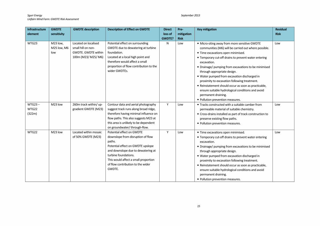
Table 2.3: Risk Assessment Matrix
Infrastructure
element
GWDTE
sensitivity
GWDTE description Description of Effect on GWDTE Direct
loss of
GWDTE?
Pre-
mitigation
Risk
Key mitigation Residual
Risk
WTG1
M23 low,
M15 low
Nearest GWDTE is
200m east – mosaic
consisting of 25%
GWDTE (M23/ M15)
GWDTE is 200m from WTG and is
characterised by small hollows/
valleys i.e. the catchment area of the
through-flow component is very
localised in extent. Turbine therefore
unlikely to affect flow contribution to
GWDTE.
N Negligible • Time excavations open minimised and excavations
reinstated as soon as practicable.
• Temporary cut-off drains to prevent water entering
excavation.
• Pollution prevention measures.
Negligible
Track WTG1 –
WTG2
(556m)
M23 low,
M15 low
134m of track located
within GWDTE (M15/
M23)
Track located within GWDTE
orientated perpendicular to dominant
flow direction, potentially disrupting/
altering flow paths and affecting
GWDTE up-slope and downslope.
Y Medium • Tracks constructed with a suitable camber from
permeable material of suitable chemistry.
• Cross-drains installed as part of track construction to
preserve existing flow paths.
• Pollution prevention measures.
Low
WTG2 M15 low M15 habitat at and
upslope of turbine.
Moderately sloping ground upslope of
turbine. Localised risk to GWDTE
upslope from dewatering at turbine
foundations.
This would affect a small proportion
of flow contribution to the wider
GWDTE.
Y Localised • Time excavations open minimised.
• Temporary cut-off drains to prevent water entering
excavation.
• Drainage/ pumping from excavations to be minimised
through appropriate design.
• Water pumped from excavation discharged in
proximity to excavation following treatment.
• Reinstatement should occur as soon as practicable,
ensure suitable hydrological conditions and avoid
permanent draining.
• Pollution prevention measures.
Low
Track WTG2 –
WTG3 (416m)
and WTG3
M23 low,
M15 low
M25 low
Majority of track passes
through GWDTE (M23/
M25/ M15)
Track generally oriented
perpendicular to dominant flow
direction on moderately sloping
ground, potentially disrupting/
altering flow paths and affecting
GWDTE up-slope and downslope.
Y Medium • Tracks constructed with a suitable camber from
permeable material of suitable chemistry.
• Cross-drains installed as part of track construction to
preserve existing flow paths.
• Pollution prevention measures.
Low

Sgurr Energy September 2013
Linfairn Wind Farm: GWDTE Risk Assessment
7
Infrastructure
element
GWDTE
sensitivity
GWDTE description Description of Effect on GWDTE Direct
loss of
GWDTE?
Pre-
mitigation
Risk
Key mitigation Residual
Risk
WTG3 M23 low,
M15 low
M25 low
Located within GWDTE
(M23/ M25/ M15)
Potential effect on GWDTE
downslope from disruption of flow
paths, and upslope and downslope
due to dewatering at turbine
foundations.
This would affect a small proportion
of flow contribution to the wider
GWDTE.
Y Low • Time excavations open minimised.
• Temporary cut-off drains to prevent water entering
excavation.
• Drainage/ pumping from excavations to be minimised
through appropriate design.
• Water pumped from excavation discharged in
proximity to excavation following treatment.
• Reinstatement should occur as soon as practicable,
ensure suitable hydrological conditions and avoid
permanent draining.
• Pollution prevention measures.
Low
Track WTG3 –
WTG4
including spur
(~1km)
M23 low
M25 low
650m track through/
up-gradient of GWDTE
(M23/ M25)
Track generally oriented
perpendicular to dominant flow
direction on moderate/ low gradient
slopes, potentially disrupting/ altering
flow paths and affecting GWDTE up-
slope and downslope.
Y Medium • Tracks constructed with a suitable camber from
permeable material of suitable chemistry.
• Cross-drains installed as part of track construction to
preserve existing flow paths.
• Pollution prevention measures.
Low
WTG4 M23 low
M25 low
Located within GWDTE
(M23/ M25)
Potential effect on GWDTE
downslope from disruption of flow
paths, and upslope and downslope
due to dewatering at turbine
foundations.
This would affect a small proportion
of flow contribution to the wider
GWDTE.
Y Low • Time excavations open minimised.
• Temporary cut-off drains to prevent water entering
excavation.
• Drainage/ pumping from excavations to be minimised
through appropriate design.
• Water pumped from excavation discharged in
proximity to excavation following treatment.
• Reinstatement should occur as soon as practicable,
ensure suitable hydrological conditions and avoid
permanent draining.
• Pollution prevention measures.
Low
Sgurr Energy September 2013
Linfairn Wind Farm: GWDTE Risk Assessment
8
Infrastructure
element
GWDTE
sensitivity
GWDTE description Description of Effect on GWDTE Direct
loss of
GWDTE?
Pre-
mitigation
Risk
Key mitigation Residual
Risk
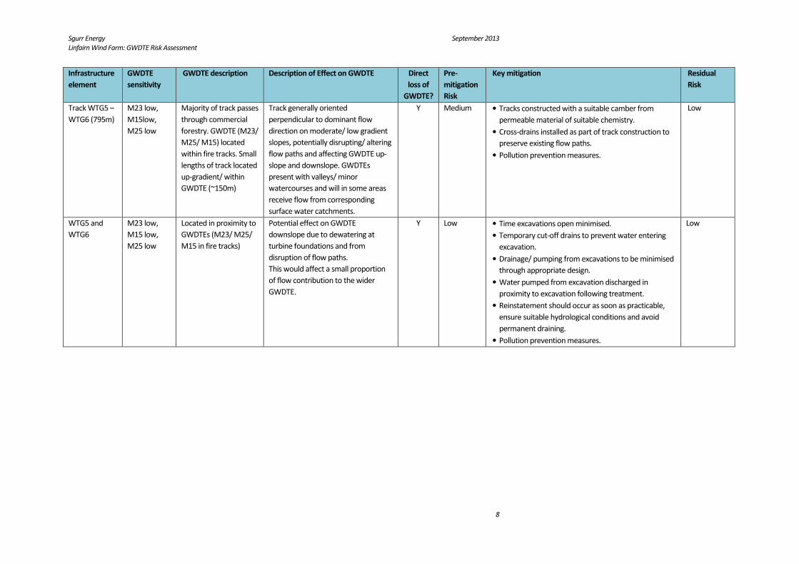
Track WTG5 –
WTG6 (795m)
M23 low,
M15low,
M25 low
Majority of track passes
through commercial
forestry. GWDTE (M23/
M25/ M15) located
within fire tracks. Small
lengths of track located
up-gradient/ within
GWDTE (~150m)
Track generally oriented
perpendicular to dominant flow
direction on moderate/ low gradient
slopes, potentially disrupting/ altering
flow paths and affecting GWDTE up-
slope and downslope. GWDTEs
present with valleys/ minor
watercourses and will in some areas
receive flow from corresponding
surface water catchments.
Y Medium • Tracks constructed with a suitable camber from
permeable material of suitable chemistry.
• Cross-drains installed as part of track construction to
preserve existing flow paths.
• Pollution prevention measures.
Low
WTG5 and
WTG6
M23 low,
M15 low,
M25 low
Located in proximity to
GWDTEs (M23/ M25/
M15 in fire tracks)
Potential effect on GWDTE
downslope due to dewatering at
turbine foundations and from
disruption of flow paths.
This would affect a small proportion
of flow contribution to the wider
GWDTE.
Y Low • Time excavations open minimised.
• Temporary cut-off drains to prevent water entering
excavation.
• Drainage/ pumping from excavations to be minimised
through appropriate design.
• Water pumped from excavation discharged in
proximity to excavation following treatment.
• Reinstatement should occur as soon as practicable,
ensure suitable hydrological conditions and avoid
permanent draining.
• Pollution prevention measures.
Low
Sgurr Energy September 2013
Linfairn Wind Farm: GWDTE Risk Assessment
9
Infrastructure
element
GWDTE
sensitivity
GWDTE description Description of Effect on GWDTE Direct
loss of
GWDTE?
Pre-
mitigation
Risk
Key mitigation Residual
Risk
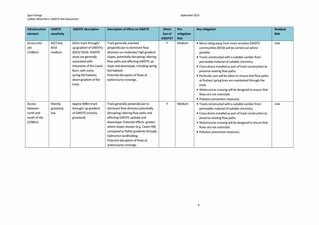
Access into
site
(1580m)
M23 low,
M10
medium
642m track through/
up-gradient of GWDTEs
(M23/ M10). GWDTE
areas are generally
associated with
tributaries of the Cawin
Burn, with some
spring-fed habitats
down-gradient of the
track.
Track generally oriented
perpendicular to dominant flow
direction on moderate/ high gradient
slopes, potentially disrupting/ altering
flow paths and affecting GWDTE up-
slope and downslope, including spring
fed habitats.
Potential disruption of flows at
watercourse crossings.
Y Medium • Micro-siting away from more sensitive GWDTE
communities (M10) will be carried out where
possible.
• Tracks constructed with a suitable camber from
permeable material of suitable chemistry.
• Cross-drains installed as part of track construction to
preserve existing flow paths.
• Particular care will be taken to ensure that flow paths
at flushes/ spring lines are maintained through the
track.
• Watercourse crossing will be designed to ensure that
flows are not restricted.
• Pollution prevention measures.
Low
Access
between
north and
south of site
(2586m)
Marshy
grassland,
low
Approx 408m track
through/ up-gradient
of GWDTE (marshy
grassland)
Track generally perpendicular to
dominant flow direction potentially
disrupting/ altering flow paths and
affecting GWDTE upslope and
downslope. Potential effects greater
where slopes steeper (e.g. Cawin Hill)
compared to flatter gradients through
Dalmorton landholding.
Potential disruption of flows at
watercourse crossings.
Y Medium • Tracks constructed with a suitable camber from
permeable material of suitable chemistry.
• Cross-drains installed as part of track construction to
preserve existing flow paths.
• Watercourse crossing will be designed to ensure that
flows are not restricted.
• Pollution prevention measures.
Low

Sgurr Energy September 2013
Linfairn Wind Farm: GWDTE Risk Assessment
10
Infrastructure
element
GWDTE
sensitivity
GWDTE description Description of Effect on GWDTE Direct
loss of
GWDTE?
Pre-
mitigation
Risk
Key mitigation Residual
Risk
Access to
WTG7 (970m)
M23 low, M6
low, M10
medium
322m of track through
GWDTE (M23/ M10,
localised M6)
Majority of track runs parallel to the
dominant flow direction on moderate
gradient slopes. Track may act as a
preferential flow path but will have a
limited effect on proportion of flow to
the GWDTE.
Potential disruption of flows at
watercourse crossing.
Y Low • Micro-siting away from more sensitive GWDTE
communities (M10 and M6) will be carried out where
possible.
• Tracks constructed with a suitable camber from
permeable material of suitable chemistry.
• Cross-drains installed as part of track construction to
ensure that track does not act as preferential flow
path.
• Watercourse crossing will be designed to ensure that
flows are not restricted.
• Pollution prevention measures.
Negligible
WTG7 M23 low Located within GWDTE
(M23)
Potential effect on GWDTE
downslope from disruption of flow
paths, on lower gradient slopes.
Potential effect on GWDTE upslope
and downslope due to dewatering at
turbine foundations.
This would affect a small proportion
of flow contribution to the wider
GWDTE.
Y Low • Time excavations open minimised.
• Temporary cut-off drains to prevent water entering
excavation.
• Drainage/ pumping from excavations to be minimised
through appropriate design.
• Water pumped from excavation discharged in
proximity to excavation following treatment.
• Reinstatement should occur as soon as practicable,
ensure suitable hydrological conditions and avoid
permanent draining.
• Pollution prevention measures.
Low
WTG7 to
WTG8 (355m)
M23 low,
M10
medium
105m track located
within GWDTE
(M23/M10)
Track oriented parallel to dominant
flow direction. Track may act as a
preferential flow path but will have
limited effect on proportion of flow to
GWDTE.
Y Low • Micro-siting away from more sensitive GWDTE
communities (M10) will be carried out where
possible.
• Tracks constructed with a suitable camber from
permeable material of suitable chemistry.
• Cross-drains installed as part of track construction to
ensure that track does not act as preferential flow
path.
• Pollution prevention measures.
Low

Sgurr Energy September 2013
Linfairn Wind Farm: GWDTE Risk Assessment
11
Infrastructure
element
GWDTE
sensitivity
GWDTE description Description of Effect on GWDTE Direct
loss of
GWDTE?
Pre-
mitigation
Risk
Key mitigation Residual
Risk
WTG8 M23 low,
M10
medium
Located within GWDTE
(M23/ M10)
Potential effect on GWDTE
downslope from disruption of flow
paths.
Potential effect on GWDTE upslope
and downslope due to dewatering at
turbine foundations.
Turbine and crane pad located across
a significant part of the GWDTE and
could therefore have a greater effect
on flow contribution.
Y Medium • Micro-siting away from more sensitive GWDTE
communities (M10) will be carried out where
possible.
• Time excavations open minimised.
• Temporary cut-off drains to prevent water entering
excavation.
• Drainage/ pumping from excavations to be minimised
through appropriate design.
• Water pumped from excavation discharged in
proximity to excavation following treatment.
• Reinstatement should occur as soon as practicable,
ensure suitable hydrological conditions and avoid
permanent draining.
• Pollution prevention measures.
Low
WTG8 to
WTG9
M23 low,
M10
medium, M6
low
210m track located
within GWDTE (M23/
M10, localised area
M6)
Track generally perpendicular to
dominant flow direction potentially
disrupting/ altering flow paths and
affecting GWDTE upslope and
downslope.
Potential disruption of flows at
watercourse crossings.
Y Medium • Micro-siting away from more sensitive GWDTE
communities (M10 and M6) will be carried out where
possible.
• Tracks constructed with a suitable camber from
permeable material of suitable chemistry.
• Cross-drains installed as part of track construction to
ensure that track does not act as preferential flow
path.
• Watercourse crossing will be designed to ensure that
flows are not restricted.
• Pollution prevention measures.
Low
Sgurr Energy September 2013
Linfairn Wind Farm: GWDTE Risk Assessment
12
Infrastructure
element
GWDTE
sensitivity
GWDTE description Description of Effect on GWDTE Direct
loss of
GWDTE?
Pre-
mitigation
Risk
Key mitigation Residual
Risk
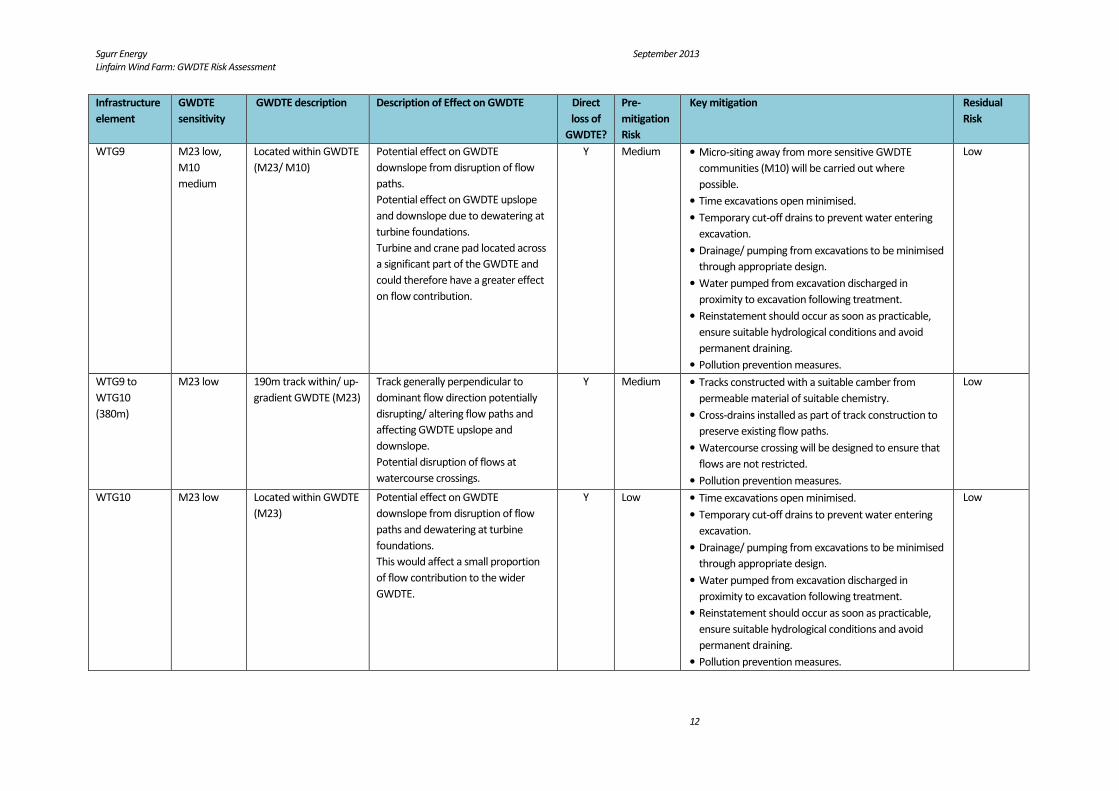
WTG9 M23 low,
M10
medium
Located within GWDTE
(M23/ M10)
Potential effect on GWDTE
downslope from disruption of flow
paths.
Potential effect on GWDTE upslope
and downslope due to dewatering at
turbine foundations.
Turbine and crane pad located across
a significant part of the GWDTE and
could therefore have a greater effect
on flow contribution.
Y Medium • Micro-siting away from more sensitive GWDTE
communities (M10) will be carried out where
possible.
• Time excavations open minimised.
• Temporary cut-off drains to prevent water entering
excavation.
• Drainage/ pumping from excavations to be minimised
through appropriate design.
• Water pumped from excavation discharged in
proximity to excavation following treatment.
• Reinstatement should occur as soon as practicable,
ensure suitable hydrological conditions and avoid
permanent draining.
• Pollution prevention measures.
Low
WTG9 to
WTG10
(380m)
M23 low 190m track within/ up-
gradient GWDTE (M23)
Track generally perpendicular to
dominant flow direction potentially
disrupting/ altering flow paths and
affecting GWDTE upslope and
downslope.
Potential disruption of flows at
watercourse crossings.
Y Medium • Tracks constructed with a suitable camber from
permeable material of suitable chemistry.
• Cross-drains installed as part of track construction to
preserve existing flow paths.
• Watercourse crossing will be designed to ensure that
flows are not restricted.
• Pollution prevention measures.
Low
WTG10 M23 low Located within GWDTE
(M23)
Potential effect on GWDTE
downslope from disruption of flow
paths and dewatering at turbine
foundations.
This would affect a small proportion
of flow contribution to the wider
GWDTE.
Y Low • Time excavations open minimised.
• Temporary cut-off drains to prevent water entering
excavation.
• Drainage/ pumping from excavations to be minimised
through appropriate design.
• Water pumped from excavation discharged in
proximity to excavation following treatment.
• Reinstatement should occur as soon as practicable,
ensure suitable hydrological conditions and avoid
permanent draining.
• Pollution prevention measures.
Low

Sgurr Energy September 2013
Linfairn Wind Farm: GWDTE Risk Assessment
13
Infrastructure
element
GWDTE
sensitivity
GWDTE description Description of Effect on GWDTE Direct
loss of
GWDTE?
Pre-
mitigation
Risk
Key mitigation Residual
Risk
WTG10 to
WTG11
(390m)
M23 low 320m track within/ up-
gradient GWDTE (M23)
Track perpendicular to dominant flow
direction potentially disrupting/
altering flow paths and affecting
GWDTE upslope and downslope.
Y Medium • Tracks constructed with a suitable camber from
permeable material of suitable chemistry.
• Cross-drains installed as part of track construction to
preserve existing flow paths.
• Pollution prevention measures.
Low
WTG11 M23 low Located within GWDTE
(M23)
Potential effect on GWDTE
downslope from disruption of flow
paths.
Potential effect on GWDTE upslope
and downslope due to dewatering at
turbine foundations.
This would affect a small proportion
of flow contribution to the wider
GWDTE.
Y Low • Time excavations open minimised.
• Temporary cut-off drains to prevent water entering
excavation.
• Drainage/ pumping from excavations to be minimised
through appropriate design.
• Water pumped from excavation discharged in
proximity to excavation following treatment.
• Reinstatement should occur as soon as practicable,
ensure suitable hydrological conditions and avoid
permanent draining.
• Pollution prevention measures.
Low
WTG11 –
WTG12
(376m)
M23 low 376m track within
GWDTE (M23)
Track generally oriented parallel to
dominant flow direction. Track may
act as a preferential flow path but will
have limited influence on proportion
of flow to GWDTE.
Potential disruption of flows at
watercourse crossings.
Y Low • Tracks constructed with a suitable camber from
permeable material of suitable chemistry.
• Cross-drains installed as part of track construction to
ensure track does not act as preferential flow path.
• Watercourse crossing will be designed to ensure that
flows are not restricted.
• Pollution prevention measures.
Low
Sgurr Energy September 2013
Linfairn Wind Farm: GWDTE Risk Assessment
14
Infrastructure
element
GWDTE
sensitivity
GWDTE description Description of Effect on GWDTE Direct
loss of
GWDTE?
Pre-
mitigation
Risk
Key mitigation Residual
Risk
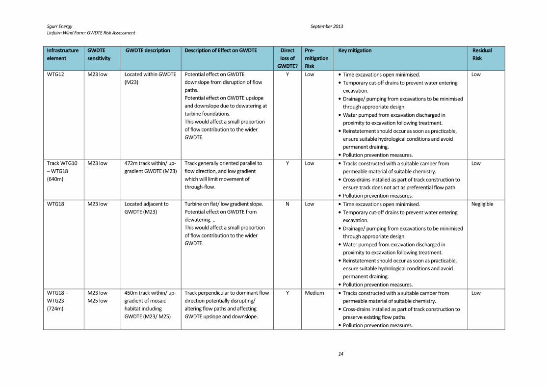
WTG12 M23 low Located within GWDTE
(M23)
Potential effect on GWDTE
downslope from disruption of flow
paths.
Potential effect on GWDTE upslope
and downslope due to dewatering at
turbine foundations.
This would affect a small proportion
of flow contribution to the wider
GWDTE.
Y Low • Time excavations open minimised.
• Temporary cut-off drains to prevent water entering
excavation.
• Drainage/ pumping from excavations to be minimised
through appropriate design.
• Water pumped from excavation discharged in
proximity to excavation following treatment.
• Reinstatement should occur as soon as practicable,
ensure suitable hydrological conditions and avoid
permanent draining.
• Pollution prevention measures.
Low
Track WTG10
– WTG18
(640m)
M23 low 472m track within/ up-
gradient GWDTE (M23)
Track generally oriented parallel to
flow direction, and low gradient
which will limit movement of
through-flow.
Y Low • Tracks constructed with a suitable camber from
permeable material of suitable chemistry.
• Cross-drains installed as part of track construction to
ensure track does not act as preferential flow path.
• Pollution prevention measures.
Low
WTG18 M23 low Located adjacent to
GWDTE (M23)
Turbine on flat/ low gradient slope.
Potential effect on GWDTE from
dewatering. ,.
This would affect a small proportion
of flow contribution to the wider
GWDTE.
N Low • Time excavations open minimised.
• Temporary cut-off drains to prevent water entering
excavation.
• Drainage/ pumping from excavations to be minimised
through appropriate design.
• Water pumped from excavation discharged in
proximity to excavation following treatment.
• Reinstatement should occur as soon as practicable,
ensure suitable hydrological conditions and avoid
permanent draining.
• Pollution prevention measures.
Negligible
WTG18 -
WTG23
(724m)
M23 low
M25 low
450m track within/ up-
gradient of mosaic
habitat including
GWDTE (M23/ M25)
Track perpendicular to dominant flow
direction potentially disrupting/
altering flow paths and affecting
GWDTE upslope and downslope.
Y Medium • Tracks constructed with a suitable camber from
permeable material of suitable chemistry.
• Cross-drains installed as part of track construction to
preserve existing flow paths.
• Pollution prevention measures.
Low
Sgurr Energy September 2013
Linfairn Wind Farm: GWDTE Risk Assessment
15
Infrastructure
element
GWDTE
sensitivity
GWDTE description Description of Effect on GWDTE Direct
loss of
GWDTE?
Pre-
mitigation
Risk
Key mitigation Residual
Risk
WTG23 M23 low,
M25 low, M6
low
Located on localised
small hill on non-
GWDTE. GWDTE within
100m (M23/ M25/ M6)
Potential effect on surrounding
GWDTE due to dewatering at turbine
foundation.
Located at a local high point and
therefore would affect a small
proportion of flow contribution to the
wider GWDTEs.
N Low • Micro-siting away from more sensitive GWDTE
communities (M6) will be carried out where possible.
• Time excavations open minimised.
• Temporary cut-off drains to prevent water entering
excavation.
• Drainage/ pumping from excavations to be minimised
through appropriate design.
• Water pumped from excavation discharged in
proximity to excavation following treatment.
• Reinstatement should occur as soon as practicable,
ensure suitable hydrological conditions and avoid
permanent draining.
• Pollution prevention measures.
Low
WTG23 –
WTG22
(322m)
M23 low 260m track within/ up-
gradient GWDTE (M23)
Contour data and aerial photography
suggest track runs along broad ridge,
therefore having minimal influence on
flow paths. This also suggests M23 at
this area is unlikely to be dependent
on groundwater/ through-flow.
Y Low • Tracks constructed with a suitable camber from
permeable material of suitable chemistry.
• Cross-drains installed as part of track construction to
preserve existing flow paths.
• Pollution prevention measures.
Low
WTG22 M23 low Located within mosaic
of 50% GWDTE (M23)
Potential effect on GWDTE
downslope from disruption of flow
paths.
Potential effect on GWDTE upslope
and downslope due to dewatering at
turbine foundations.
This would affect a small proportion
of flow contribution to the wider
GWDTE.
Y Low • Time excavations open minimised.
• Temporary cut-off drains to prevent water entering
excavation.
• Drainage/ pumping from excavations to be minimised
through appropriate design.
• Water pumped from excavation discharged in
proximity to excavation following treatment.
• Reinstatement should occur as soon as practicable,
ensure suitable hydrological conditions and avoid
permanent draining.
• Pollution prevention measures.
Low

Sgurr Energy September 2013
Linfairn Wind Farm: GWDTE Risk Assessment
16
Infrastructure
element
GWDTE
sensitivity
GWDTE description Description of Effect on GWDTE Direct
loss of
GWDTE?
Pre-
mitigation
Risk
Key mitigation Residual
Risk
WTG22 –
WTG25
(690m)
M23 low
M25 low
M6 low
545m of track within/
up-gradient of GWDTE
(M23/ M25/ M6)
Local valley between WTG22 and
WTG25. On slopes near turbines
(330m), M23/ M25 and track
generally parallel to flow direction
therefore limited effect on proportion
of flow contributing to GWDTE.
Within valley, valley mire complex
including M25 and M6 with small
watercourse. Track perpendicular to
flow direction (215m) but flat/ low
gradient, therefore lower likelihood of
disrupting flow paths to GWDTE.
Potential disruption of flows at
watercourse crossings.
Y Medium • Micro-siting away from more sensitive GWDTE
communities (M6) will be carried out where possible.
• Tracks constructed with a suitable camber from
permeable material of suitable chemistry.
• Cross-drains installed as part of track construction to
preserve existing flow paths/ ensure that track does
not act as preferential flow path.
• Particular care will be taken to ensure that flow paths
at flushes/ spring lines are maintained through the
track.
• Watercourse crossing will be designed to ensure that
flows are not restricted.
• Pollution prevention measures.
Low
WTG25 M23 low
M25 low
Located within GWDTE
(M23/ M25)
Potential effect on GWDTE
downslope from disruption of flow
paths.
Potential effect on GWDTE upslope
and downslope due to dewatering at
turbine foundations.
This would affect a small proportion
of flow contribution to the wider
GWDTE.
Y Low • Time excavations open minimised.
• Temporary cut-off drains to prevent water entering
excavation.
• Drainage/ pumping from excavations to be minimised
through appropriate design.
• Water pumped from excavation discharged in
proximity to excavation following treatment.
• Reinstatement should occur as soon as practicable,
ensure suitable hydrological conditions and avoid
permanent draining.
• Pollution prevention measures.
Low
WTG25 –
WTG24
(440m)
M23 low
M25 low
M6 low
440m within GWDTE
(M23/ M25, localised
M6)
Track generally oriented parallel to
dominant flow direction and on low
gradient with minimal disruption to
flow paths.
Y Low • Micro-siting away from more sensitive GWDTE
communities (M6) will be carried out where possible.
• Tracks constructed with a suitable camber from
permeable material of suitable chemistry.
• Cross-drains installed as part of track construction to
ensure track does not act as preferential flow path.
• Pollution prevention measures.
Low

Sgurr Energy September 2013
Linfairn Wind Farm: GWDTE Risk Assessment
17
Infrastructure
element
GWDTE
sensitivity
GWDTE description Description of Effect on GWDTE Direct
loss of
GWDTE?
Pre-
mitigation
Risk
Key mitigation Residual
Risk
WTG24 M23 low
M25 low
Located within GWDTE
(M23/ M25)
Potential effect on GWDTE
downslope from disruption of flow
paths.
Potential effect on GWDTE upslope
and downslope due to dewatering at
turbine foundations.
This would affect a small proportion
of flow contribution to the wider
GWDTE.
Y Low • Time excavations open minimised.
• Temporary cut-off drains to prevent water entering
excavation.
• Drainage/ pumping from excavations to be minimised
through appropriate design.
• Water pumped from excavation discharged in
proximity to excavation following treatment.
• Reinstatement should occur as soon as practicable,
ensure suitable hydrological conditions and avoid
permanent draining.
• Pollution prevention measures.
Low
WTG24 –
WTG19
(470m)
M23, M25,
M6 low, M15
low
470m track within
GWDTE (M23/ M25/
M15, localised M6)
Track partially oriented parallel to
flow direction, with minimal influence
on flow paths contribution to the
GWDTE, and partially perpendicular
with disruption of flow paths.
Potential disruption of flows at
watercourse crossings.
Y Medium • Micro-siting away from more sensitive GWDTE
communities (M6) will be carried out where possible.
• Tracks constructed with a suitable camber from
permeable material of suitable chemistry.
• Cross-drains installed as part of track construction to
preserve existing flow paths/ ensure track does not
act as a preferential flow path.
• Particular care will be taken to ensure that flow paths
at flushes/ spring lines are maintained through the
track.
• Watercourse crossing will be designed to ensure that
flows are not restricted.
• Pollution prevention measures.
Low
Sgurr Energy September 2013
Linfairn Wind Farm: GWDTE Risk Assessment
18
Infrastructure
element
GWDTE
sensitivity
GWDTE description Description of Effect on GWDTE Direct
loss of
GWDTE?
Pre-
mitigation
Risk
Key mitigation Residual
Risk
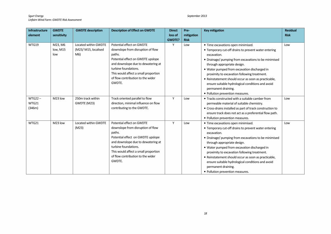
WTG19 M23, M6
low, M15
low
Located within GWDTE
(M23/ M15, localised
M6)
Potential effect on GWDTE
downslope from disruption of flow
paths.
Potential effect on GWDTE upslope
and downslope due to dewatering at
turbine foundations.
This would affect a small proportion
of flow contribution to the wider
GWDTE.
Y Low • Time excavations open minimised.
• Temporary cut-off drains to prevent water entering
excavation.
• Drainage/ pumping from excavations to be minimised
through appropriate design.
• Water pumped from excavation discharged in
proximity to excavation following treatment.
• Reinstatement should occur as soon as practicable,
ensure suitable hydrological conditions and avoid
permanent draining.
• Pollution prevention measures.
Low
WTG22 –
WTG21
(346m)
M23 low 250m track within
GWDTE (M23)
Track oriented parallel to flow
direction, minimal influence on flow
contributing to the GWDTE.
Y Low • Tracks constructed with a suitable camber from
permeable material of suitable chemistry.
• Cross-drains installed as part of track construction to
ensure track does not act as a preferential flow path.
• Pollution prevention measures.
Low
WTG21 M23 low Located within GWDTE
(M23)
Potential effect on GWDTE
downslope from disruption of flow
paths.
Potential effect on GWDTE upslope
and downslope due to dewatering at
turbine foundations.
This would affect a small proportion
of flow contribution to the wider
GWDTE.
Y Low • Time excavations open minimised.
• Temporary cut-off drains to prevent water entering
excavation.
• Drainage/ pumping from excavations to be minimised
through appropriate design.
• Water pumped from excavation discharged in
proximity to excavation following treatment.
• Reinstatement should occur as soon as practicable,
ensure suitable hydrological conditions and avoid
permanent draining.
• Pollution prevention measures.
Low
Sgurr Energy September 2013
Linfairn Wind Farm: GWDTE Risk Assessment
19
Infrastructure
element
GWDTE
sensitivity
GWDTE description Description of Effect on GWDTE Direct
loss of
GWDTE?
Pre-
mitigation
Risk
Key mitigation Residual
Risk
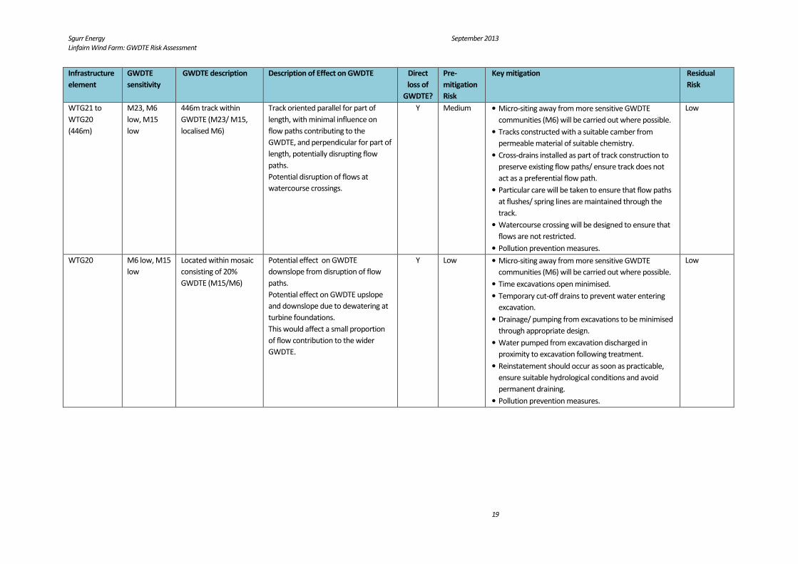
WTG21 to
WTG20
(446m)
M23, M6
low, M15
low
446m track within
GWDTE (M23/ M15,
localised M6)
Track oriented parallel for part of
length, with minimal influence on
flow paths contributing to the
GWDTE, and perpendicular for part of
length, potentially disrupting flow
paths.
Potential disruption of flows at
watercourse crossings.
Y Medium • Micro-siting away from more sensitive GWDTE
communities (M6) will be carried out where possible.
• Tracks constructed with a suitable camber from
permeable material of suitable chemistry.
• Cross-drains installed as part of track construction to
preserve existing flow paths/ ensure track does not
act as a preferential flow path.
• Particular care will be taken to ensure that flow paths
at flushes/ spring lines are maintained through the
track.
• Watercourse crossing will be designed to ensure that
flows are not restricted.
• Pollution prevention measures.
Low
WTG20 M6 low, M15
low
Located within mosaic
consisting of 20%
GWDTE (M15/M6)
Potential effect on GWDTE
downslope from disruption of flow
paths.
Potential effect on GWDTE upslope
and downslope due to dewatering at
turbine foundations.
This would affect a small proportion
of flow contribution to the wider
GWDTE.
Y Low • Micro-siting away from more sensitive GWDTE
communities (M6) will be carried out where possible.
• Time excavations open minimised.
• Temporary cut-off drains to prevent water entering
excavation.
• Drainage/ pumping from excavations to be minimised
through appropriate design.
• Water pumped from excavation discharged in
proximity to excavation following treatment.
• Reinstatement should occur as soon as practicable,
ensure suitable hydrological conditions and avoid
permanent draining.
• Pollution prevention measures.
Low

Sgurr Energy September 2013
Linfairn Wind Farm: GWDTE Risk Assessment
20
Infrastructure
element
GWDTE
sensitivity
GWDTE description Description of Effect on GWDTE Direct
loss of
GWDTE?
Pre-
mitigation
Risk
Key mitigation Residual
Risk
WTG20 –
WTG13
(785m)
M23 low,
M10
medium
385m track within
GWDTE (M23, localised
M10)
Track partially parallel to flow path
with minimal influence on flow paths
contributing to the GWDTE, partially
perpendicular potentially disrupting
flow paths.
Potential disruption of flows at
watercourse crossings.
Y Medium • Micro-siting away from more sensitive GWDTE
communities (M10) will be carried out where
possible.
• Tracks constructed with a suitable camber from
permeable material of suitable chemistry.
• Cross-drains installed as part of track construction to
preserve existing flow paths/ ensure track does not
act as a preferential flow path.
• Particular care will be taken to ensure that flow paths
at flushes/ spring lines are maintained through the
track.
• Pollution prevention measures.
Low
WTG13 M23, M25,
M6 low, M15
low, M10
medium
Located adjacent to
GWDTE (M23/ M25/
M15/ M6/ M10
mosaics)
Potential effect on GWDTE
downslope due to flow path
disruption and dewatering at turbine
foundations.
Potential effect on GWDTE adjacent
due to dewatering.
Crane pad located across linear M10
and M6 feature.
N High • Micro-siting away from more sensitive GWDTE
communities (M10 and M6) will be carried out where
possible.
• Time excavations open minimised.
• Temporary cut-off drains to prevent water entering
excavation.
• Drainage/ pumping from excavations to be minimised
through appropriate design.
• Water pumped from excavation discharged in
proximity to excavation following treatment.
• Reinstatement should occur as soon as practicable,
ensure suitable hydrological conditions and avoid
permanent draining.
• Pollution prevention measures.
Low
Track to
WTG17
(600m)
M23 low 140m track within
GWDTE (M23)
Track perpendicular to dominant flow
direction, however location of spur
track on broad ridge minimises
potential disruption to flow paths.
Y Low • Tracks constructed with a suitable camber from
permeable material of suitable chemistry.
• Cross-drains installed as part of track construction to
preserve existing flow paths.
• Pollution prevention measures.
Low

Sgurr Energy September 2013
Linfairn Wind Farm: GWDTE Risk Assessment
21
Infrastructure
element
GWDTE
sensitivity
GWDTE description Description of Effect on GWDTE Direct
loss of
GWDTE?
Pre-
mitigation
Risk
Key mitigation Residual
Risk
WTG17 M23 low Located adjacent to
GWDTE (M23)
Turbine on localised higher point with
dominant flow direction towards
valley to NE. GWDTE (M23) situated
to NW, potential influence on flow
contribution to GWDTE from
dewatering only.
N Low • Time excavations open minimised.
• Temporary cut-off drains to prevent water entering
excavation.
• Drainage/ pumping from excavations to be minimised
through appropriate design.
• Water pumped from excavation discharged in
proximity to excavation following treatment.
• Reinstatement should occur as soon as practicable,
ensure suitable hydrological conditions and avoid
permanent draining.
• Pollution prevention measures.
Negligble
WTG17 spur
to WTG16
(154m)
M23 low 94m track within
GWDTE (M23)
Track oriented parallel to dominant
flow direction, with minimal influence
on flow paths contributing to GWDTE.
Y Low • Tracks constructed with a suitable camber from
permeable material of suitable chemistry.
• Cross-drains installed as part of track construction to
ensure track does not act as a preferential flow path.
• Pollution prevention measures.
Low
WTG16 M23 low Located adjacent to
GWDTE (M23)
Potential effect on GWDTE adjacent
due to dewatering at turbine
foundations.
Turbine and crane pad located
adjacent to GWDTE but parallel to
flow paths and unlikely to have a
significant effect on overall flow
contribution.
Y Low • Time excavations open minimised.
• Temporary cut-off drains to prevent water entering
excavation.
• Drainage/ pumping from excavations to be minimised
through appropriate design.
• Water pumped from excavation discharged in
proximity to excavation following treatment.
• Reinstatement should occur as soon as practicable,
ensure suitable hydrological conditions and avoid
permanent draining.
• Pollution prevention measures.
Low
WTG16 –
WTG15
(345m)
M23 low 100m track within
GWDTE (M23)
Track transversal to dominant flow
direction potentially disrupting/
altering flow paths and affecting
GWDTE upslope and downslope.
Y Medium • Tracks constructed with a suitable camber from
permeable material of suitable chemistry.
• Cross-drains installed as part of track construction to
preserve existing flow paths.
• Pollution prevention measures.
Low

Sgurr Energy September 2013
Linfairn Wind Farm: GWDTE Risk Assessment
22
Infrastructure
element
GWDTE
sensitivity
GWDTE description Description of Effect on GWDTE Direct
loss of
GWDTE?
Pre-
mitigation
Risk
Key mitigation Residual
Risk
WTG15 M23 low Located up-gradient of
GWDTE (M23)
Potential effect on GWDTE
downslope due to flow path
disruption and dewatering at turbine
foundations.
N Medium • Time excavations open minimised.
• Temporary cut-off drains to prevent water entering
excavation.
• Drainage/ pumping from excavations to be minimised
through appropriate design.
• Water pumped from excavation discharged in
proximity to excavation following treatment.
• Reinstatement should occur as soon as practicable,
ensure suitable hydrological conditions and avoid
permanent draining.
• Pollution prevention measures.
Low
WTG15 to
WTG14
(470m)
M23 low 470m located within/
up-gradient of GWDTE
(M23)
Track generally perpendicular to
dominant flow direction potentially
disrupting/ altering flow paths and
affecting GWDTE downslope.
Y Medium
• Tracks constructed with a suitable camber from
permeable material of suitable chemistry.
• Cross-drains installed as part of track construction to
preserve existing flow paths.
• Pollution prevention measures.
Low
WTG14 M23 low Located within GWDTE
(M23)
Potential effect on GWDTE
downslope from disruption of flow
paths.
Potential effect on GWDTE upslope
and downslope due to dewatering at
turbine foundations.
This would affect a small proportion
of flow contribution to the wider
GWDTE.
Y Low • Time excavations open minimised.
• Temporary cut-off drains to prevent water entering
excavation.
• Drainage/ pumping from excavations to be minimised
through appropriate design.
• Water pumped from excavation discharged in
proximity to excavation following treatment.
• Reinstatement should occur as soon as practicable,
ensure suitable hydrological conditions and avoid
permanent draining.
• Pollution prevention measures.
Low

Sgurr Energy September 2013
Linfairn Wind Farm: GWDTE Risk Assessment
23
3. MITIGATION MEASURES
Mitigation measures to minimise the potential impacts of the development on GWDTEs are provided for each
infrastructure element in Table 2.3, and are summarised below:
General:
• Micro-siting of infrastructure away from the more highly groundwater-dependent GWDTEs (M10 and M6)
will be undertaken where possible.
• It is proposed that the existing drainage and flow paths (shallow groundwater and surface water) will be
maintained around construction areas.
• Groundwater and surface water drainage arrangements for construction elements will be in line with the
principles of sustainable drainage systems (SuDS) by incorporating appropriate attenuation and treatment.
This approach will be in line with the SuDS Manual (C697) published by CIRIA and the CAR Practical Guide.
• Mitigation measures will be incorporated into the Environmental Management Plan for the site.
Excavations for turbine foundations and borrow pits:
• The time any excavation is open will be kept to a minimum to avoid ingress of water and dewatering.
• Temporary cut off drains will be installed to prevent surface water and shallow through-flow entering into
excavations. Clean water will be discharged downstream of the excavation and encouraged to infiltrate into
the ground mimicking natural flow patterns.
• Drainage or pumping from excavations will be minimised through appropriate design.
• Runoff and any water pumped from excavations in proximity to GWDTES will be discharged in proximity of
the excavation (mimicking natural flow patterns) after being passed through a SuDS feature. Infiltration of
flows will be encouraged (e.g. use of swales). Concentration of flows at the discharge point(s) will be avoided.
• Reinstatement of excavations will be reinstated as soon as practicable once construction works are complete
and will ensure that suitable hydrological conditions are restored, avoiding permanent drainage.
Track construction & drainage:
• All tracks will be constructed with a suitable camber and will have a permeable, granular surface.
• Tracks will be constructed from material of a suitable chemistry i.e. that will not have an adverse impact on
the local soil/ groundwater chemistry.
• Where the tracks are oriented parallel to the dominant flow direction, transverse drains (‘grips’) will be
constructed, where appropriate, in the surface of the tracks to convey runoff from the road into the drainage
ditch, thereby preventing the tracks from acting as preferential flow paths.
• Where access tracks are oriented perpendicular to the dominant flow direction the trackside drainage will
include a lateral drainage channel cut along the uphill side of the track to intercept the natural runoff and
shallow groundwater flow and this will be conducted under the track at regular intervals through cross
drains. The trackside drains will be broad and shallow with moderate gradients to prevent scouring. Flows
from this drainage will be treated by filtration through check dams and settlement at sumps.
• Where appropriate, swales will be used along the access tracks to hold water temporarily and to encourage
infiltration/discharge into the ground locally. Check dams will be placed regularly along the swales to reduce
flow velocities and maximise infiltration.
• All existing land drainage passing under the tracks will be preserved or reinstated to ensure that the existing,
drainage regimes are maintained. This includes all watercourses, drains, flushes, springs and peat pipes.
• Watercourse crossings will be designed to ensure that flows are not restricted or concentrated downstream.
• During the operation phase, any drains associated with tracks will be inspected periodically and cleaned out
as necessary.

Sgurr Energy September 2013
Linfairn Wind Farm: GWDTE Risk Assessment
24
• Impermeable plugs at regular intervals will be used when backfilling cable trenches to ensure that the trench
does not act as a preferential pathway.
Oil, Fuel and Site Vehicle Use and Storage:
• Oil and fuel storage areas will be impermeable and bunded.
• No fuelling or maintenance of vehicles and machinery will be carried out within GWDTE and cleaning of tools
will be carried out in a designated area in line with PPG 7.
• Spill kits will be kept on site.
• Regular inspection and maintenance of vehicles, tanks and bunds will be undertaken.
• The Pollution Incident Response Plan for the site will include measures to deal with any accidental spillages.
Concrete
• Pouring of concrete for turbine bases will take place within well shuttered pours to prevent egress of
concrete from the pour area.
• Pouring of concrete during adverse weather conditions will be avoided.
• Concrete pH will be as close to background pH as practicable.