![Arte pop [pop art]](https://static.fdocuments.in/doc/165x107/558d408ad8b42aa44f8b4706/arte-pop-pop-art.jpg)
SETTLEMENT PRIORITIES - Waterberg District Municipality 1... · settlement priorities mogalakwena...
57
SETTLEMENT PRIORITIES Mogalakwena NAME POP SIZE (2011) POP GROWTH NR HOUSEHOLDS HH SIZE AREA (ha) POP DENSITY INF SETTL MOKOPANE, MOGALAKWENA (previously Potgietersrus) 120 601 4% 31 779 3.49 6 037.88 20p/ha 4% SOCIO – ECON SERVICES ECON SECTOR No income: 15% Below R38k: 50% Unemployed: 12% Higher education: 9% Dominated by economically active population. High dependency ratio due to the majority of the population aged between 0-14 Elec: 92% Sanit: 57% Water: 75% Refuse: 61% Fixed capital investment: 3 rd highest. Mostly in tertiary sector. Largest sector GVA: mining Largest employer: wholesale High locational quotient: mining, electricity, transport Low locational quotient: manufacturing Contribution to GVA: 2 nd Primary: 2 nd ; secondary: 1 st ; tertiary: 1 st IMPORTANT DIVERSIFIED AND DEVELOPED ECONOMY STRENGTH LIES IN SECONDARY AND TERTIARY SECTORS BACKGROUND ACCESS Early exploration for platinum on Platreef in 1920s. The focus is around Mokopane and includes the activities and land uses in Mahwelereng. However, Mahwelereng starts to exhibit the features of a peri-urban area with elements of subsistence farming on the fringes of the denser residential components. Excellent: Direct: N11 passes through. Adjacent: N1, R518, R101 On NS railway line LOCATIONAL CHARACTERISTICS SDF PROPOSALS SOCIAL FACILITIES Biosphere: No Mining: Platinum and coal; existing and potential to the north Agricultural: surrounded by priority area (intensive commercial) and wildlife Tourism: cultural and natural Land under traditional authority Small villages to north EMF: Urbanisation focus areas, Agricultural High potential for growth Rerouting of N11 – remove through traffic but could have economic impact Functions as regional service centre No development of sub-centres but Mahwelereng might warrant low level neighbourhood centre Infill and growth towards the north Primary schools: 29 Secondary schools: 19 Tertiary edu: 1 FET & TC Health: 2 hospitals; 5 clinics Government: 1 municipal, 0 district, 13 government Police stations: 3 Magistrates Court: 2
Transcript of SETTLEMENT PRIORITIES - Waterberg District Municipality 1... · settlement priorities mogalakwena...

SETTLEMENT PRIORITIES
Mogalakwena
NAME POP SIZE
(2011) POP
GROWTH NR
HOUSEHOLDS HH SIZE AREA (ha) POP DENSITY INF SETTL
MOKOPANE, MOGALAKWENA (previously Potgietersrus)
120 601 4% 31 779 3.49 6 037.88 20p/ha 4%
SOCIO – ECON SERVICES ECON SECTOR No income: 15% Below R38k: 50% Unemployed: 12% Higher education: 9% Dominated by economically active population. High dependency ratio due to the majority of the population aged between 0-14
Elec: 92% Sanit: 57% Water: 75% Refuse: 61%
Fixed capital investment: 3rd highest. Mostly in tertiary sector. Largest sector GVA: mining Largest employer: wholesale High locational quotient: mining, electricity, transport Low locational quotient: manufacturing Contribution to GVA: 2nd Primary: 2nd; secondary: 1st; tertiary: 1st IMPORTANT DIVERSIFIED AND DEVELOPED ECONOMY STRENGTH LIES IN SECONDARY AND TERTIARY SECTORS BACKGROUND ACCESS
Early exploration for platinum on Platreef in 1920s. The focus is around Mokopane and includes the activities and land uses in Mahwelereng. However, Mahwelereng starts to exhibit the features of a peri-urban area with elements of subsistence farming on the fringes of the denser residential components.
Excellent: Direct: N11 passes through. Adjacent: N1, R518, R101 On NS railway line
LOCATIONAL CHARACTERISTICS SDF PROPOSALS SOCIAL FACILITIES
Biosphere: No Mining: Platinum and coal; existing and potential to the north Agricultural: surrounded by priority area (intensive commercial) and wildlife Tourism: cultural and natural Land under traditional authority Small villages to north EMF: Urbanisation focus areas, Agricultural
High potential for growth Rerouting of N11 – remove through traffic but could have economic impact Functions as regional service centre No development of sub-centres but Mahwelereng might warrant low level neighbourhood centre Infill and growth towards the north
Primary schools: 29 Secondary schools: 19 Tertiary edu: 1 FET & TC Health: 2 hospitals; 5 clinics Government: 1 municipal, 0 district, 13 government Police stations: 3 Magistrates Court: 2
priority areas with a commercial focus (intensive)
GROWTH NODAL HIERARCHY ISSUES TO BE ADDRESSED Regional service centre Oversupply of high income res. Undersupply of low income res: Horizontal expansion and infill: different income groups growing together Needed 3 600 units until 2017
PGP in all SDFs Largest population Largest regional service centre. Continued anticipated growth Diversified and strong local economy
PROPOSAL: PGP
Increased demand from regional business facilities to be addressed in CBD Low income housing The municipality owns a substantial amount of strategically located land.
Figure 1: MOKOPANE SPATIAL DEVELOPMENT FRAMEWORK.

NAME POP SIZE
(2011) POP
GROWTH NR
HOUSEHOLDS HH SIZE AREA (ha) POP DENSITY INF SETTL
MMOTONG/ BAKENBERG, MOGALAKWENA
6 877 2.5 1 892 3.47 504.57 14p/ha 4%
SOCIO – ECON SERVICES No income: 18% Below R38k: 66% Unemployed: 11% Higher education: 4%
Elec: 95% Sanit: 2% Water: 54% Refuse: 1%
BACKGROUND ACCESS Informal village, Servicing surrounding area in northern parts of Mogalakwena
Centrally located in the rural area. Constituted by the Mmotong village.
Limited, the D3556-D4380 route connects the villages, including Bakenberg, with the N11 and R518 into Mokopane town to the south and the N11 again in the north towards Rebone.
LOCATIONAL CHARACTERISTICS SDF PROPOSALS SOCIAL FACILITIES Biosphere: No, but in close proximityto Transition 1 Zone Mining: No Agricultural: Agriculture is not encouraged. Game and cattle farming in this zone should not detract from the tourism experience of the zone. The land capability for agriculture is mainly low-moderate. Tourism: EMF indicates that there is significant potential for the development of nature and/or culture based tourism Traditional authority: Yes Small villages: Yes, the area is surrounded by various small villages EMF: Nature and cultural tourism focus areas within a high quality natural setting. Water extraction in this area should be minimal
One of two service points for providing and establishing higher level government and municipal functions To provide basis for public amenities and services to meet daily needs of rural communities. Focus non-residential activities along the north-south main road through the village with core in the south closer to the schools to the east of the main road and south of the intersection immediately north of the schools. Facilitate orderly growth and provide infrastructure and facilities to allow regional facilities to establish in node
Primary schools: 4 Secondary schools: 2 Combined: 0 Tertiary edu: 0 Health: 1 Clinic Government: 1 Govt Police stations: 0 Magistrates Court: 0
GROWTH NODAL HIERARCHY ISSUES TO BE ADDRESSED Very little growth or growth potential but plays crucial role in bringing facilities closer to population.
LPSDF: MGP LMSDF: downgraded to municipal service points – non-aligned terminology
PROPOSAL: MGP
Formalisation of settlements with suitable land tenure arrangements Creating opportunities for the establishment of a regional community service centre as current services are of a low order

Figure 2: BAKENBERG SPATIAL DEVELOPMENT PROPOSALS

NAME POP SIZE
(2011) POP
GROWTH NR
HOUSEHOLDS HH SIZE AREA (ha) POP DENSITY INF SETTL
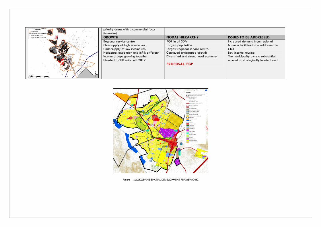
REBONE, MOGALAKWENA
4 179 5 1 118 3.74 271.39 15p/ha 3%
SOCIO – ECON SERVICES No income: 12% Below R38k: 68% Unemployed: 5% Higher education: 4%
Elec: 75% Sanit: 60% Water: 86% Refuse: 79%
BACKGROUND ACCESS Delivery of services to surrounds, north of Mogalakwena and up to Botswana. Servicing surrounding areas in the northern parts of Mogalakwena. Emphasis on creating opportunities for establishing regional community facilities and services as required Subsistence farming Able to service northern areas up to Botswana border Area between town and main road required for infill development if required
Very good: N11
LOCATIONAL CHARACTERISTICS SDF PROPOSALS SOCIAL FACILITIES Biosphere: No Mining: No Agricultural: Intensive grazing to the south Tourism: Natural and cultural tourism Proclaimed nature reserve to north Traditional authority: No Small villages: To the east EMF: Protection of the natural vegetation, landscape and rock paintings areas, with limited appropriate tourism
To serve as the point for providing and establishing higher level government and commercial functions should it be necessary
Primary schools: 1 Secondary schools: 1 Combined: 0 Tertiary edu: 0 Health: 1 Clinic Government: 0 Police stations: 0 Magistrates Court: 0
GROWTH NODAL HIERARCHY ISSUES TO BE ADDRESSED Very little growth or growth potential but necessary to provide rural communities with access to services and facilities Limit growth to proclaimed land and discourage extensive urban development Substantial number of vacant business and residential stands
LPSDF: MGP LMSDF: Municipal Service Point
PROPOSAL: PCP
Limit development within an urban edge and promote infill development in the area between the town and the
Figure 3: REBONE SPATIAL DEVELOPMENT PROPOSALS

NAME POP SIZE
(2011) POP
GROWTH NR
HOUSEHOLDS HH SIZE AREA (ha) POP DENSITY INF SETTL
MABUSELA CLUSTER, MOGALAKWENA (GA-MODIPANA, KWAKWALATA, GA-
MOSEGE, MAPELA, MATOPA, FOTHANE, MABUELA, RAMORULANE, MAHLOGO,
GA-TSHABA),
9 666 2 2 526 3.6 1235.84 8 p/ha 2%
SOCIO – ECON SERVICES No income: 16% Below R38k: 67% Unemployed: 11% Higher education: 3%
Elec: 94% Sanit: 2% Water: 61% Refuse: 1%
BACKGROUND ACCESS Situated between the D3556-D4380 route as well as the R518 to Mokopane.
Fair: at intersection of D4380, this links it to Mokopane in the south and Mmotong in the north, and D1958, which links the area to the N11 to the east and the R518 to the west.
LOCATIONAL CHARACTERISTICS SDF PROPOSALS SOCIAL FACILITIES Biosphere: No Mining: Yes, in close proximity to Mokopane Platinum MineAgricultural: Yes, Subsitance Tourism: Yes, Cultural tourism due to close proximity to the Heritage route Traditional authority:Yes Small villages: EMF: Nature and cultural tourism focus area within high quality natural setting
Situated along the D3556 and D4380 that links Mogalakwena villages to the N11 and Mokopane.
Primary schools: 7 Secondary schools: 4 Combined: 0 Tertiary edu: 0 Health: 1 Mobile Clinic Government: - Police stations: 1 Magistrates Court: -
GROWTH NODAL HIERARCHY ISSUES TO BE ADDRESSED Area to be focused on servicing surrounding settlements in the southern areas of Mogalakwena. Subsitence farming for food security purposes, but taking into account scarce water resources in the District. Encourage cultural tourism in the area
LPSDF: MGP, 4th Order, 5th Order PROPOSAL: PCP
Focus on servicing surrounding areas and farming More services to be focussed in this area Infill development in vacant areas between settlements Need to address issues of illegal water connections RDP housing

NAME POP SIZE
(2011) POP
GROWTH NR
HOUSEHOLDS HH SIZE AREA (ha) POP DENSITY INF SETTL
MATLOU/ GA-MAPELA, MOGALAKWENA (GA-MAPELA, GA-MASENYA)
5 407 1% 1 427 3.7 612.43 9p/ha 13
SOCIO – ECON SERVICES No income: 20% Below R38k: 69 % Unemployed: 11% Higher education: 3%
Elec: 97% Sanit: 1% Water: 61% Refuse: 0 %
BACKGROUND ACCESS
Agricultural rural settlement located close to
Mokopane
Limited: R518
LOCATIONAL CHARACTERISTICS SDF PROPOSALS SOCIAL FACILITIES Biosphere: no Mining: Yes,near platinum mine Agricultural: no, existing and potential mining Tourism: No Traditional authority: No Small villages: Yes EMF: Restricted mining focus area in aesthetic/ ecological resource area
Scrapped as service centre in Mogalakwena SDF due to its proximity to the town Ga-Matlou service point is in close proximity to the urban core and the level of potential investment by the Council cannot warrant such a service point
Primary schools: 1 Secondary schools: 2 Combined: 0 Tertiary edu: 0 Health: 1 Clinic Government: 0 Police stations: 0 Magistrates Court: 0
GROWTH NODAL HIERARCHY ISSUES TO BE ADDRESSED The growth of this area must maily focus on meeting housing demand, providing basic needs to the settlement and surrounds, and encouraging infill delopment between the settlements
LPSDF: LSP LMSDF - scraps as service point PROPOSAL: LSP
Focus on providing basic needs to surrounds. However, not to a great extent due to the area’s close proximity to Mokopane. Upgrading of medical services Satellite police station Recreational facilities required in the area

NAME POP SIZE
(2011) POP
GROWTH NR
HOUSEHOLDS HH SIZE AREA (ha) POP DENSITY INF SETTL
MARKEN, MOGALAKWENA
+/- 120 No Data No Data No Data 24.32 5p/ha No Data
BACKGROUND ACCESS
Falls within Lephalale’s sphere of influence and serves a very sparsely and isolated area
Fair: lies where the R518 to Setateng & Lephalale to the west & the R561 to the N11-Botswana in the north & Touchstone Nature Reserve to the south intersect
LOCATIONAL CHARACTERISTICS SDF PROPOSALS SOCIAL FACILITIES Biosphere: Yes; Transition 1 Zone Mining: No Agricultural: Game & Cattle Farming Tourism: Yes, situated near Touchstone Nature Reserve and is part of theBisosphere Reserve Traditional authority: Yes Small villages: Yes EMF: Major infrastructure corridor areas; Nature and cultural tourism focus areas within a high quality natural setting
Smaller nodes with a very limited or no economic base Can possibly establish itself as a tourism support town for this area.
Primary schools: 1 Secondary schools:0 Combined: 0 Tertiary edu: 0 Health: 0 Government: 0 Police stations: 0 Magistrates Court: 0
GROWTH NODAL HIERARCHY ISSUES TO BE ADDRESSED The establishment of game lodges and other environmental tourism activities should be encouraged.
LPSDF: LSP Scrapped as node in LMSDF PROPOSAL: LSP
D3564/D3556 to Gilead in the ease nedds to be upgraded Tourism activities to be encouraged
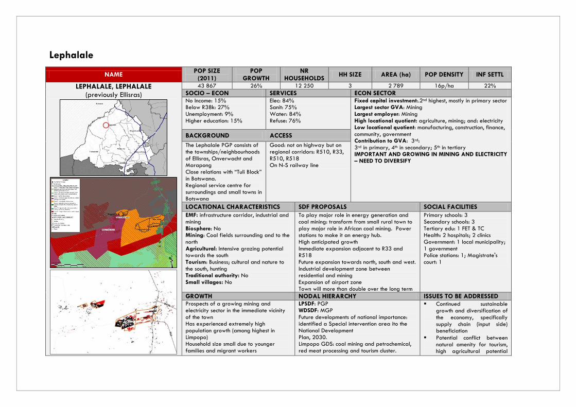
Lephalale
NAME POP SIZE
(2011) POP
GROWTH NR
HOUSEHOLDS HH SIZE AREA (ha) POP DENSITY INF SETTL
LEPHALALE, LEPHALALE (previously Ellisras)
43 867 26% 12 250 3 2 789 16p/ha 22%
SOCIO – ECON SERVICES ECON SECTOR No Income: 15% Below R38k: 27% Unemployment: 9% Higher education: 15%
Elec: 84% Sanit: 75% Water: 84% Refuse: 76%
Fixed capital investment:.2nd highest, mostly in primary sector Largest sector GVA: Mining Largest employer: Mining High locational quotient: agriculture, mining; and: electricity Low locational quotient: manufacturing, construction, finance, community, government Contribution to GVA: 3rd: 3rd in primary, 4th in secondary; 5th in tertiary IMPORTANT AND GROWING IN MINING AND ELECTRICITY – NEED TO DIVERSIFY
BACKGROUND ACCESS
The Lephalale PGP consists of the townships/neighbourhoods of Ellisras, Onverwacht and Marapong Close relations with “Tuli Block” in Botswana. Regional service centre for surroundings and small towns in Botswana
Good: not on highway but on regional corridors: R510, R33, R510, R518 On N-S railway line
LOCATIONAL CHARACTERISTICS SDF PROPOSALS SOCIAL FACILITIES
EMF: infrastructure corridor, industrial and mining Biosphere: No Mining: Coal fields surrounding and to the north Agricultural: Intensive grazing potential towards the south Tourism: Business; cultural and nature to the south, hunting Traditional authority: No Small villages: No
To play major role in energy generation and coal mining: transform from small rural town to play major role in African coal mining. Power stations to make it an energy hub. High anticipated growth Immediate expansion adjacent to R33 and R518 Future expansion towards north, south and west. Industrial development zone between residential and mining Expansion of airport zone Town will more than double over the long term
Primary schools: 3 Secondary schools: 3 Tertiary edu: 1 FET & TC Health: 2 hospitals; 2 clinics Government: 1 local municipality; 1 government Police stations: 1; Magistrate's court: 1
GROWTH NODAL HIERARCHY ISSUES TO BE ADDRESSED Prospects of a growing mining and electricity sector in the immediate vicinity of the town Has experienced extremely high population growth (among highest in Limpopo) Household size small due to younger families and migrant workers
LPSDF: PGP WDSDF: MGP Future developments of national importance: identified a Special intervention area ito the National Development Plan, 2030. Limpopo GDS: coal mining and petrochemical, red meat processing and tourism cluster.
Continued sustainable growth and diversification of the economy, specifically supply chain (input side) beneficiation
Potential conflict between natural amenity for tourism, high agricultural potential

Vertical 'sprawl' as opposed to densification Proposed Long Haul Freight Rail Linkage by Transnet will pass through this area and greatly increase its growth potential overtime
PROPOSAL: PGP
and mining and industrial development
Fluctuating population due to phasing of construction
Need for affordable rental accommodation
Figure 4: LEPHALALE SPATIAL DEVELOPMENT FRAMEWORK

NAME POP SIZE
(2011) POP
GROWTH NR
HOUSEHOLDS HH SIZE AREA (ha) POP DENSITY INF SETTL
THABO MBEKI, LEPHALALE (WITPOORT, LEPURUPUNG)
3 110 2.8 1 056 2.3 257.84 12p/ha 1%
SOCIO – ECON SERVICES No income: 19% Below R38k: 54% Unemployed: 7% Higher education: 6%
Elec: 76% Sanit: 12% Water: 98% Refuse: 62%
BACKGROUND ACCESS Centrally located to provide essential services to surrounding settlements. Consists of the townships/settlements of Lepurupurung, Witpoort and Thabo Mbeki. A district hospital is located here, as well as other services
Limited Situated along the D3100 route, the link between the R518 in the south and R572 in the north
LOCATIONAL CHARACTERISTICS SDF PROPOSALS SOCIAL FACILITIES Biosphere: No Mining: No Agricultural: Yes, Subsistence Tourism: No Traditional authority: No Small villages: Yes, the area is surrounded by various small villages EMF: Zone 8: Rural settlement support area.
Proposed to serve the rural settlements in the eastern parts of Lephalale Municipality. Due to central location wrt rural areas, current facilities including availability of engineering services, and higher order functions proposed to serve rural settlements to the east thus higher level than merely local service point should be the node in rural areas that is more important and to accommodate higher level of services and activities, if required It is therefore most suitable to Secondary Activity Node which may contain shopping centre and/or Thusong Centre
Primary schools: 1 Secondary schools: 1 Combined: 0 Tertiary edu: 0 Health: 1 District hospital, 1 CHC Government: 1 LM Police stations: 1 Magistrates Court: 1
GROWTH NODAL HIERARCHY ISSUES TO BE ADDRESSED IDP projects negative growth A localised development master plan might be required to guide the growth of this area to accommodate Residential development and business development. Business development should be focused on already formalised areas
MSDF: LSP, LMSDF 4th Order
PROPOSAL: MGP
Active intervention to stimulate local economic development in order to positively impact on surroundings A master or detail framework plan is still required

Figure 5: THABO MBEKI SPATIAL DEVELOPMENT PROPOSALS
NAME POP SIZE
(2011) POP
GROWTH NR
HOUSEHOLDS HH SIZE AREA (ha) POP DENSITY INF SETTL
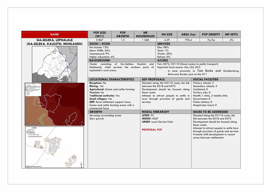
GA-SELEKA, LEPHALALE (GA-SELEKA, KAULETSI, MOHLASEDI)
5 867 1.3 1 368 4.29 796.4 7p/ha 4%
SOCIO – ECON SERVICES No income: 13% Below R38k: 56% Unemployed: 9% Higher education: 4%
Elec: 98% Sanit: 1% Water: 50% Refuse: 0%
BACKGROUND ACCESS Cluster consisting of Ga-Seleka, Kauletsi and Mohlasedi, which services the northern parts of Lephalale’s rural areas.
Fair: R572, D3110 (Good access to public transport) Important local access: LS4, LS5, DC3
In close proximity to Tom Burke and Groblersbrug
Botswana Border post on the N11
LOCATIONAL CHARACTERISTICS SDF PROPOSALS SOCIAL FACILITIES Biosphere: No Mining: No Agricultural: Game and cattle farming Tourism: No Traditional authority: Yes Small villages: Yes EMF: Rural settlement support area; Game and cattle farming areas with a commercial focus
Situated along the D3110 route, the link between the R518 and R572 Development should be focused along these routes Attempt to attract people to settle in town through provision of goods and services
Primary schools: 2 Secondary schools: 3 Combined: 0 Tertiary edu: 0 Health: 1 clinic, 2 mobile clinic Government: 0 Police stations: 0 Magistrates Court: 0
GROWTH NODAL HIERARCHY ISSUES TO BE ADDRESSED Servicing surrounding areas Slow growth
LPSDF: PC WDSDF: MGP LMSDF: Local Service Point
PROPOSAL: PCP
Situated along the D3110 route, the link between the R518 and R572 Development should be focused along these routes Attempt to attract people to settle here through provision of goods and services Promote infill development in vacant areas between settlements

Figure 6: GA SELEKA SPATIAL DEVELOPMENT PROPOSALS

NAME POP SIZE
(2011) POP
GROWTH NR
HOUSEHOLDS HH SIZE AREA (ha) POP DENSITY INF SETTL
SETATENG, LEPHALALE (SEFATENG) (SETATENG, GA-MONYEKI, MATLADI,
PHAHLADIRA)
11 824 1 2 593 4.7 1051.05 11p/ha 16%
SOCIO – ECON SERVICES No income: 12% Below R38k: 49% Unemployed: 14% Higher education: 3%
Elec: 97% Sanit: 2% Water: 64% Refuse: 1%
BACKGROUND ACCESS Consists of the settlements of Setateng, Ga-Monyeki and Mmathaldi Located 40km east of Lephalale town
Fair: R518 (Development corridor 1 in Local SDF linking area with
Lephalale town and Steenbokpan), D3110 (Good access to public
transport)
LOCATIONAL CHARACTERISTICS SDF PROPOSALS SOCIAL FACILITIES Biosphere: No Mining: No Agricultural: Agriculture priority area and game and cattle farming (intensive commercial) Tourism: No Traditional authority: Yes Small villages: Yes EMF: Rural settlement support area, Major infrastructure corridor
Situated along the D3110 route, the link between the R518 and R572. Development should be focussed along these routes R572 links N11 and R510 both connecting with Botswana Phahladira to form part of cluster Needs to offer a level of social services and low level business needs
Primary schools: 4 Secondary schools: 3 Combined: 0 Tertiary edu: 0 Health: 1 clinic Shogoane; Government: 1 LM Police stations: Yes Magistrates Court: 1 Periodical
GROWTH NODAL HIERARCHY ISSUES TO BE ADDRESSED Service surrounding areas Area to be utilised for future residential and business development Encourage industrial development where there are existing rights
LMSDF & LSPDF: PCP PROPOSAL: PCP
Link to Botswana Infrastructure provisioning Area is very close to current Biosphere, there may be some environmental issues to take into account Phahladira is to form part of this cluster. Infill development in vacant areas between settlements

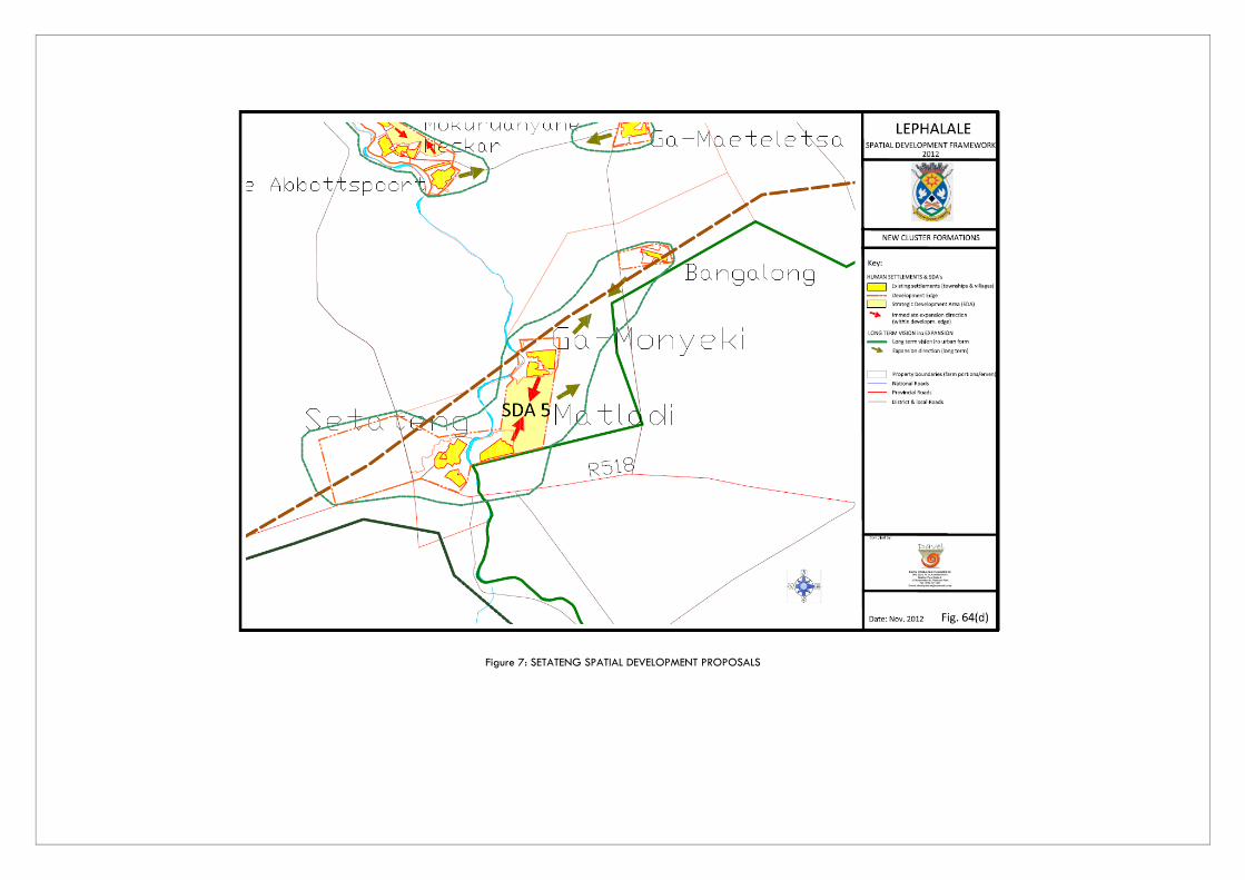
Figure 7: SETATENG SPATIAL DEVELOPMENT PROPOSALS

NAME POP SIZE
(2011) POP
GROWTH NR
HOUSEHOLDS HH SIZE AREA (ha) POP DENSITY INF SETTL
ABBOTTSPOORT, LEPHALALE (ABBOTTSPOORT, MARTINIQUE, NECKER, DIKGOPENG, NKOTOMENG, DITLOUNG)
6 167 2 1 476 4 975.52 6p/ha 5%
SOCIO – ECON SERVICES No income: 14% Below R38k: 55% Unemployed: 11% Higher education: 4%
Elec: 93% Sanit: 1% Water: 83% Refuse: 1%
BACKGROUND ACCESS This area is aimed at filling the small “gap” between the Thabo Mbeki and Setateng
Fair: D3110
LOCATIONAL CHARACTERISTICS SDF PROPOSALS SOCIAL FACILITIES Biosphere: No Mining: No Agricultural: Subsistenca and commercial arable farming on the west banks of the river Tourism: No Traditional authority: Yes Small villages: Yes EMF: Rural Support Area
Situated along the D3110 route, the link between the R518 and R572. Development should be focussed along this rural linkage route
Primary schools: 1 Secondary schools: 3 Combined: 0 Tertiary edu: 0 Health: 1 clinic, 1 mobile clinic Government: 0 Police stations:0 Magistrates Court: 0
GROWTH NODAL HIERARCHY ISSUES TO BE ADDRESSED To ensure that the villages such as Keletse le Mma, Kiti, Motsweding and Ga-Maeleletsa are properly served. In this node the municipality may consider a Thusong Centre
LMSDF: LSP PROPOSAL: PCP
Focus on servicing surrounding areas and farming More services to be focussed in this area Infill development in vacant areas between settlements
NAME POP SIZE
(2011) POP
GROWTH NR
HOUSEHOLDS HH SIZE AREA (ha) POP DENSITY INF SETTL
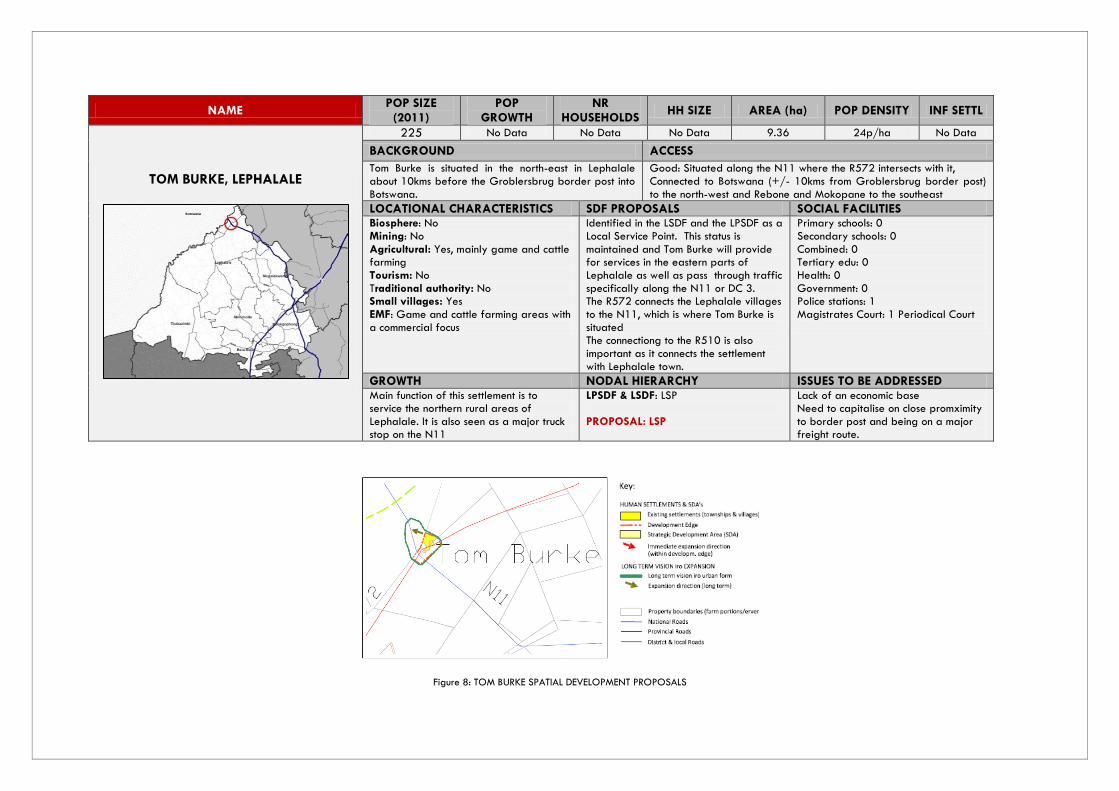
TOM BURKE, LEPHALALE
225 No Data No Data No Data 9.36 24p/ha No Data
BACKGROUND ACCESS
Tom Burke is situated in the north-east in Lephalale about 10kms before the Groblersbrug border post into Botswana.
Good: Situated along the N11 where the R572 intersects with it, Connected to Botswana (+/- 10kms from Groblersbrug border post) to the north-west and Rebone and Mokopane to the southeast
LOCATIONAL CHARACTERISTICS SDF PROPOSALS SOCIAL FACILITIES Biosphere: No Mining: No Agricultural: Yes, mainly game and cattle farming Tourism: No Traditional authority: No Small villages: Yes EMF: Game and cattle farming areas with a commercial focus
Identified in the LSDF and the LPSDF as a Local Service Point. This status is maintained and Tom Burke will provide for services in the eastern parts of Lephalale as well as pass through traffic specifically along the N11 or DC 3. The R572 connects the Lephalale villages to the N11, which is where Tom Burke is situated The connectiong to the R510 is also important as it connects the settlement with Lephalale town.
Primary schools: 0 Secondary schools: 0 Combined: 0 Tertiary edu: 0 Health: 0 Government: 0 Police stations: 1 Magistrates Court: 1 Periodical Court
GROWTH NODAL HIERARCHY ISSUES TO BE ADDRESSED Main function of this settlement is to service the northern rural areas of Lephalale. It is also seen as a major truck stop on the N11
LPSDF & LSDF: LSP PROPOSAL: LSP
Lack of an economic base Need to capitalise on close promximity to border post and being on a major freight route.
Figure 8: TOM BURKE SPATIAL DEVELOPMENT PROPOSALS

NAME POP SIZE
(2011) POP
GROWTH NR
HOUSEHOLDS HH SIZE AREA (ha) POP DENSITY INF SETTL
MARNITZ, LEPHALALE
225 No Data No Data No Data 9 25p/ha No Data
BACKGROUND ACCESS
Very small settlement along the N11 Game and cattle farming
Good: Situated along the N11 Connected to Botswana (+/- 35kms from Groblersbrug border post) to the north-west and Rebone and Mokopane to the southeast.
LOCATIONAL CHARACTERISTICS SDF PROPOSALS SOCIAL FACILITIES Biosphere: No Mining: No (but iron ore can be found here) Agricultural: Game and cattle farming (commercial) Tourism: No Traditional authority: No Small villages: No EMF: Game and cattle farming areas with a commercial focus
Identified in the LSDF and the LPSDF as a Local Service Point. This status is maintained and Marnitz, along with Tom Burke, will provide for services in the eastern parts of Lephalale as well as pass through traffic specifically along the N11 or DC 3.
Primary schools: 0 Secondary schools: 0 Combined: 0 Tertiary edu: 0 Health: 0 Government: 0 Police stations: 0 Magistrates Court: 0
GROWTH NODAL HIERARCHY ISSUES TO BE ADDRESSED Main function of this settlement is to service the northern rural areas of Lephalale. It is also seen as a major truck stop on the N11
LPSDF & LSDF: LSP PROPOSAL: LSP
Address low level of access to health facilities Lack of an economic base
Figure 9: MARNITZ SPATIAL DEVELOPMENT PROPOSALS

NAME POP SIZE
(2011) POP
GROWTH NR
HOUSEHOLDS HH SIZE AREA (ha) POP DENSITY INF SETTL
STEENBOKPAN, LEPHALALE
1 000 No Data 249 No Data 627.06 2p/ha No Data
BACKGROUND ACCESS
Falls within Lephalale’s sphere of influence and serves a very sparsely and isolated area Rich in mineral resources and in identified for future mining and for purposes of power stations. In the Lephalale SDF, it is named a Potential Development Area and falls under the Mining Zone Focus Area 3
Fair: at intersection of Development Corridor 1 (D1675) and Strategic Link 7 (D175) Located favourably to establish closer links with Botswana and associated mines to be located in the Northern District of Botswana
LOCATIONAL CHARACTERISTICS SDF PROPOSALS SOCIAL FACILITIES Biosphere: No, but in close proximity to Transition 1 Zone Mining: Yes, high coal potential area Agricultural: Game and Cattle Farming Tourism: No Traditional authority: No Small villages: No EMF: Potential large industrial and related activities focus areas
The National Development Plan, 2030 and vision of the municipality is to become the energy hub of Africa and Steenbokpan will play a big role in this. It will serve the north-western parts of Lephalale. Steenbokpan is located favourably to establish closer links with Botswana and associated mines to be located in the Northern District of Botswana. If the area between Steenbokpan and Stockpoort and Lephalale PGP develop into mining activities, Steenbokpan should not only provide limited commercial and community services to nearby located mines and power stations, but also serve as a residential area. Only on a limited scale, the housing of employees should be focused in Lephalale town as Steenbokpan is at a reasonable commutable distance.
Primary schools: 0 Secondary schools: 0 Combined: 1 Tertiary edu: 0 Health: 1 Clinic, 1 Mobile Clinic Government: 0 Police stations: 0 Magistrates Court: 0
GROWTH NODAL HIERARCHY ISSUES TO BE ADDRESSED The growth rate in this settlement is expected to rise rapidly in years to come due to the mining activities proposed in the surrounds. Bulk infrastructure and widening of roads need to start being priority projects in this area, as well as the provision of affordable rental housing However, due to its close proximity to Lephalale town, housing development should be discouraged. Rather focus on housing people in Lephalale town to avoid
Municipal Growth Point is proposed in light of LMSDF: LSP PROPOSAL: LSP
There is a need to plan the urban form in advance and in detail, since Steenbokpan will play a major role within the scope of the energy hub over the medium and long term. This planning should be done by means of compilation of a Framework Plan Upgrading of the current bulk services to accommodate development in the area. Upgrading of the Development

creating an unsustainable ‘mining town’ in Steenbokpan. There are 2 power stations planned for this area in the near future. Steenbokpan’s importance with regards to energy and mining will increase drastically in the medium to long term. Heavy vehicles will be travelling back and forth in this area.
Corridor 1 (D1675) linking Steenbokpan to Lephalale so it will be able to handle higher traffic volumes and heavy vehicles. Upgrading of other roads as well is required
Figure 10: STEENBOKPAN SPATIAL DEVELOPMENT PROPOSAL

Modimolle
NAME POP SIZE
(2011) POP GROWTH
NR HOUSEHOLDS
HH SIZE AREA (ha) POP
DENSITY INF
SETTL
MODIMOLLE, MODIMOLLE (previously Nylstroom)
41 987 3.5% 11 478 3.96 2 780.56 15p/ha 14%
SOCIO – ECON SERVICES ECON SECTOR No income: 10% Below R38k: 50% Unemployment: 10% Higher education: 7%
Elec: 83% Sanit: 83% Water: 95% Refuse: 84%
Fixed capital investment: 4th Largest sector GVA: tertiary, secondary, primary: Finance and government Largest employer: wholesale High locational quotient: agriculture, electricity, wholesale, transport, finance, government Low locational quotient: mining, manufacturing Contribution to GVA: 4th: 5th in primary, 2nd in secondary and tertiary ALTHOUGH SMALL, WELL DEVELOPED AND DIVERSIFIED ECONOMY
BACKGROUND ACCESS
Agricultural and administrative service centre Agriculture with tourism Strong tourism potential Growing tourism sector threatening agriculture most farms converted to game farms
Excellent:
close to N1, on R101, R33
R33 freight corridor due to development in Lephalale
NS railway line
LOCATIONAL CHARACTERISTICS SDF PROPOSALS SOCIAL FACILITIES
Biosphere: No, falls just outside the Biosphere, but it is a gateway into it through the R33 Mining: No Agricultural: Agriculture with tourism focus Tourism: Yes, growing, focus should be on eco-tourism based on natural and cultural features Traditional authority: No Small villages: No EMF: Agriculture focus areas with a tourism component surrounded by natural areas and; Protection of the natural vegetation, landscape and rock paintings areas, with limited appropriate tourism
Growth nodal point Land Use Management strategies to ensure protection of agricultural land
Primary schools:8 Secondary schools: 2 Combined: 0 Special School: 1 Tertiary edu: 1 Health: 3 Clinics, 1 District Hospital Government: 2 Police stations: 1, 1 satellite Magistrates Court: 1
GROWTH NODAL HIERARCHY ISSUES TO BE ADDRESSED Extensive densification and vertical sprawl Rapid population growth, due to displaced farm workers has slowed somewhat. Focus of strong agriculture activities Potential of to develop as tourism support centre.
LPSDF: PGP WDSDF: MGP Regional hub of government Agr & tourism service centre
Influence of tourism on agriculture
Protection of natural and cultural assets
Expanding on role as seat of district government and regional
PROPOSED: DGP service centre

NAME POP SIZE
(2011) POP
GROWTH NR
HOUSEHOLDS HH SIZE AREA (ha) POP DENSITY INF SETTL
MATLABANE/ VAALWATER, MODIMOLLE
16 463 8 3 366 4.65 593 28p/ha 15%
SOCIO – ECON SERVICES No income: 16% Below R38k: 59% Unemployed: 14% Higher education: 2%
Elec: 86% Sanit: 42% Water: 77% Refuse: 85%
BACKGROUND ACCESS Initially developed as service centre for local farms. In beneficial position to develop as hub of Biosphere
Good: R33 to Lephalale in the north and Modimolle in the south.
LOCATIONAL CHARACTERISTICS SDF PROPOSALS SOCIAL FACILITIES Biosphere: Transition Zone 2 Mining: No Agricultural: With tourism. Game farming Tourism: with agricultural focus Traditional authority: No Small villages: No EMF: Urbanisation focus area as well as Agriculture focus areas with a tourism component surrounded by natural areas
Service point and gateway to the Biosphere
Primary schools: 2 Secondary schools: 2 Combined: 0 Tertiary edu: 0 Health: 1 Clinic Government: 1 LM Police stations: 1 Magistrates Court: 1
GROWTH NODAL HIERARCHY ISSUES TO BE ADDRESSED Limited development potential Seen as important gateway to the biosphere Increase in the population area because of displaced farm workers
LPSDF: MGP LMSDF: PCP
PROPOSAL: PCP
Water shortage exists in the area, currently depending on boreholes Need for beautification

NAME POP SIZE
(2011) POP
GROWTH NR
HOUSEHOLDS HH SIZE AREA (ha) POP DENSITY INF SETTL
MABALENG, MODIMOLLE (ALMA)
1 554 0.42 215 7.23 82.85 18 p/ha 11%
SOCIO – ECON SERVICES No income: 13% Below R38k: 54% Unemployed: 19% Higher education:1 %
Elec: 88% Sanit: 0% Water: 85% Refuse: 90%
BACKGROUND ACCESS
Agricultural, Rural town Fair: R33
LOCATIONAL CHARACTERISTICS SDF PROPOSALS SOCIAL FACILITIES Biosphere: Transition Zone 2 Mining: No Agricultural: Yes, but should be according to the guidelines provided in the Biosphere Tourism: Yes, is along the tourism route from Bela Bela (D180) Traditional authority: No Small villages: No EMF: Agriculture with tourism
The D180 road from Bela Bela to Mabaleng (Alma) provides access to various tourism related facilities and the town is just off the tourism corridor R33. Service point agricultural town that can be classified as a fourth order node
Primary schools: 1 Secondary schools: 0 Combined: 0 Tertiary edu: 0 Health: 1 Clinic Government: 0 Police stations: 1 Satellite Magistrates Court: 0
GROWTH NODAL HIERARCHY ISSUES TO BE ADDRESSED There is little development potential Focus on sustaining minimum health conditions for residents of this area
LPSDF: LSP PROPOSAL: LSP
Lack of public transport Informal Settlements must be addressed Paving of main access roads The lack of a waste water treatment works must be addressed There is a need for a cemetery in the area, as well as a health facility
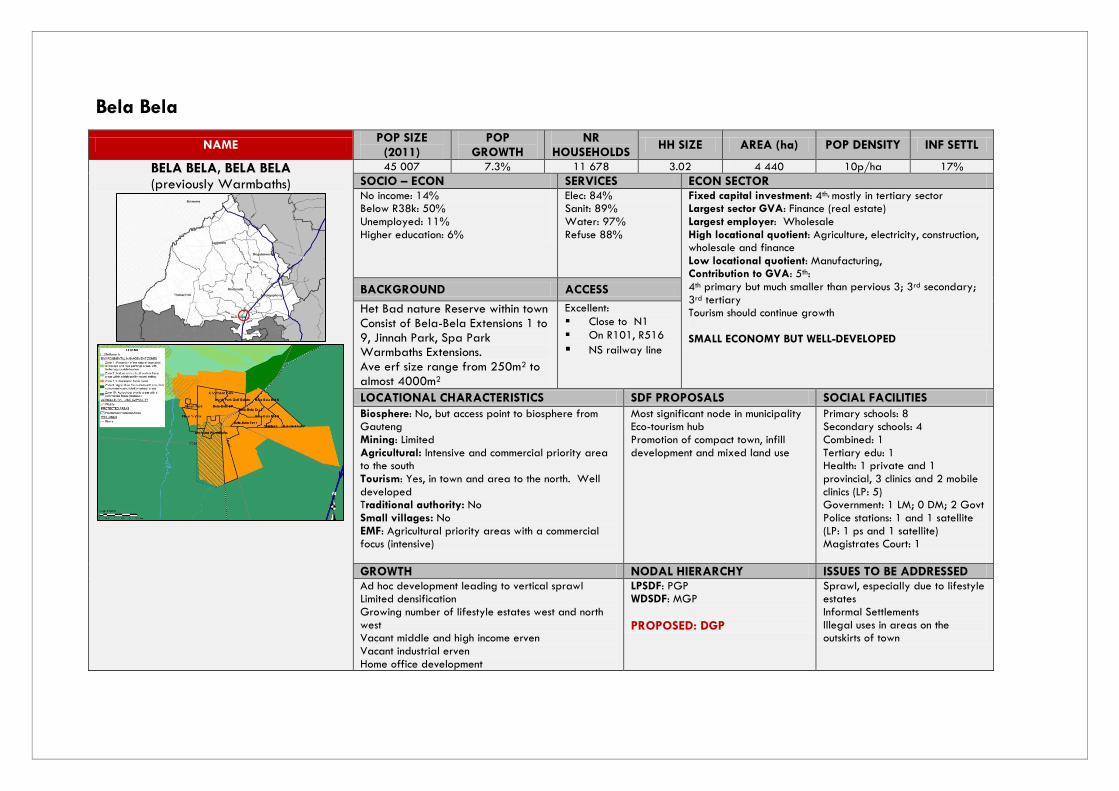
Bela Bela
NAME POP SIZE
(2011) POP
GROWTH NR
HOUSEHOLDS HH SIZE AREA (ha) POP DENSITY INF SETTL
BELA BELA, BELA BELA (previously Warmbaths)
45 007 7.3% 11 678 3.02 4 440 10p/ha 17%
SOCIO – ECON SERVICES ECON SECTOR No income: 14% Below R38k: 50% Unemployed: 11% Higher education: 6%
Elec: 84% Sanit: 89% Water: 97% Refuse 88%
Fixed capital investment: 4th, mostly in tertiary sector Largest sector GVA: Finance (real estate) Largest employer: Wholesale High locational quotient: Agriculture, electricity, construction, wholesale and finance Low locational quotient: Manufacturing, Contribution to GVA: 5th: 4th primary but much smaller than pervious 3; 3rd secondary; 3rd tertiary Tourism should continue growth SMALL ECONOMY BUT WELL-DEVELOPED
BACKGROUND ACCESS
Het Bad nature Reserve within town Consist of Bela-Bela Extensions 1 to 9, Jinnah Park, Spa Park Warmbaths Extensions. Ave erf size range from 250m2 to almost 4000m2
Excellent:
Close to N1
On R101, R516
NS railway line
LOCATIONAL CHARACTERISTICS SDF PROPOSALS SOCIAL FACILITIES
Biosphere: No, but access point to biosphere from Gauteng Mining: Limited Agricultural: Intensive and commercial priority area to the south Tourism: Yes, in town and area to the north. Well developed Traditional authority: No Small villages: No EMF: Agricultural priority areas with a commercial focus (intensive)
Most significant node in municipality Eco-tourism hub Promotion of compact town, infill development and mixed land use
Primary schools: 8 Secondary schools: 4 Combined: 1 Tertiary edu: 1 Health: 1 private and 1 provincial, 3 clinics and 2 mobile clinics (LP: 5) Government: 1 LM; 0 DM; 2 Govt Police stations: 1 and 1 satellite (LP: 1 ps and 1 satellite) Magistrates Court: 1
GROWTH NODAL HIERARCHY ISSUES TO BE ADDRESSED Ad hoc development leading to vertical sprawl Limited densification Growing number of lifestyle estates west and north west Vacant middle and high income erven Vacant industrial erven Home office development
LPSDF: PGP WDSDF: MGP
PROPOSED: DGP
Sprawl, especially due to lifestyle estates Informal Settlements Illegal uses in areas on the outskirts of town

Figure 11: BELA BELA SPATIAL DEVELOPMENT FRAMEWORK

NAME POP SIZE
(2011) POP
GROWTH NR
HOUSEHOLDS HH SIZE AREA (ha) POP DENSITY INF SETTL
PIENAARSRIVIER, BELA BELA
1 897 2.5 584 3.25 207 9p/ha 3%
SOCIO – ECON SERVICES No income: 19% Below R38k: 48% Unemployed: 10% Higher education: 5%
Elec: 98% Sanit: 98% Water: 98% Refuse: 97%
BACKGROUND ACCESS Delivery of services to surroundings Well-established Co-operation with Silos to serve the local farmers. Other business developments include amongst others petrol garages, supermarkets and small shops. Provides important convenience goods and services to surrounding communities.
Excellent: N1, R101 Railway line
LOCATIONAL CHARACTERISTICS SDF PROPOSALS SOCIAL FACILITIES Biosphere: No Mining: Existing and potential Agricultural: High potential with tourism Environment: Highly environmentally sensitive Tourism: EMF: Nature and cultural tourism focus area with high quality natural setting Traditional authority: No Small villages: No Second most important growth point in Bela Bela
Second most important growth point in municipality Development important in order to improve services and contribute to the upliftment of the area. Large number of serviced vacant erven can be made available to settle people from dispersed settlements provided that it is sustainable, cost-effective and viability over longer term.
Primary schools: 1 Secondary schools: 1 Combined: 0 Tertiary edu: Health: 1 clinic Government: 0 Police stations: 1 Magistrates Court: 1 Post office: 1 Sufficient edu fac till 2030
GROWTH NODAL HIERARCHY ISSUES TO BE ADDRESSED Vacant business erven Need to develop into more compact town Potential for growth Local economic development potential Of 1 092 erven, 680 are still vacant Six business erven but only two are developed. SDF: in 2030 approximately 2 062 people will reside in Pienaarsrivier approximately 117 additional houses will be needed
LPSDF: MGP LMSDF: MGP PROPOSAL: PCP
Improve existing services to uplift the area Resettlement of residents from dispersed surrounding settlements Develop based on the local economic growth potential.

Figure 12: PIENAARSRIVIER SPATIAL DEVELOPMENT PROPOSALS

NAME POP SIZE
(2011) POP
GROWTH NR
HOUSEHOLDS HH SIZE AREA (ha) POP DENSITY INF SETTL
RADIUM (& MASAKHANE/WELGEGUND), BELA BELA
1 448 91% 358 4 195 7p/ha 5%
SOCIO – ECON SERVICES No income: 20% Below R38k:65 % Unemployed: 6% Higher education: 1%
Elec: 93% Sanit: 95% Water: 87% Refuse: 96%
BACKGROUND ACCESS Agriculture (maize) Small town inclusive of the township known as Welgegund/Masakhane There is a small business component Generally only serving the direct surrounding farming communities and do not have a significant impact on the spatial development
Fair: R101 Lies between the N1 and the R101 (P1/3) routes linking the settlement to Bela Bela in the North and Gauteng in the south. Railway Line
LOCATIONAL CHARACTERISTICS SDF PROPOSALS SOCIAL FACILITIES Biosphere: No Mining: Potential mining Agricultural: Yes, area surrounded by arable commercial farming Tourism: No Traditional authority: No Small villages: No EMF: Agriculture priority area (intensive commercial)
Local Service Points (third order node), providing a service mainly to the local community Need for development of Masakhane on the farm Welgegund to relocate other dispersed settlements in the area such as Vingerkraal, Masakhane. settlement with ±300 erven was planned.
Primary schools: 1 Secondary schools: 0 Combined: 0 Tertiary edu: 0 Health: 0 Government: 0 Police stations: 0 Magistrates Court: 0
GROWTH NODAL HIERARCHY ISSUES TO BE ADDRESSED No substantial township development envisaged over long term Encourage growth towards agriculture
LMSDF & LPSDF: LSP PROPOSAL: LSP
Provide RDP housing Establishment of waste management site Lack of development of business plots Need for health facilities Farmers leaving the area
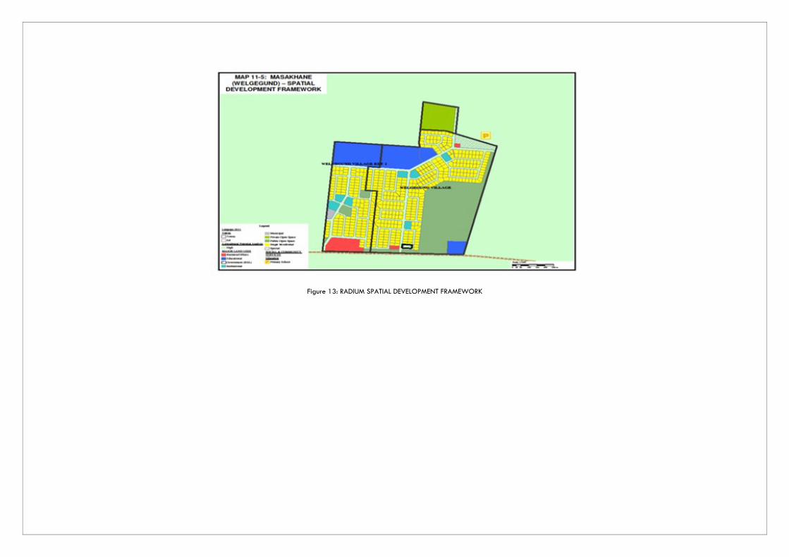
Figure 13: RADIUM SPATIAL DEVELOPMENT FRAMEWORK
NAME POP SIZE
(2011) POP
GROWTH NR
HOUSEHOLDS HH SIZE AREA (ha) POP DENSITY INF SETTL
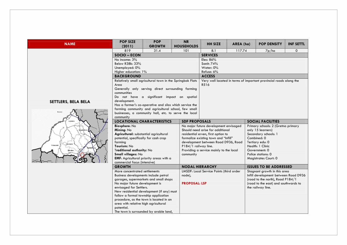
SETTLERS, BELA BELA
819 31.4 101 8.1 117.74 7p/ha 0
SOCIO – ECON SERVICES No income: 3% Below R38k: 33% Unemployed: 0% Higher education: 1%
Elec: 86% Sanit: 74% Water: 0% Refuse: 6%
BACKGROUND ACCESS Relatively small agricultural town in the Springbok Flats Area Generally only serving direct surrounding farming communities Do not have a significant impact on spatial development. Has a farmer’s co-operative and silos which service the farming community and agricultural school, few small businesses, a community hall, etc. to serve the local community
Very well located in terms of important provincial roads along the R516
LOCATIONAL CHARACTERISTICS SDF PROPOSALS SOCIAL FACILITIES Biosphere: No Mining: No Agricultural: substantial agricultural potential, specifically for cash crop farming Tourism: No Traditional authority: No Small villages: No EMF: Agricultural priority areas with a commercial focus (intensive)
No major future development envisaged Should need arise for additional residential erven, first option to formalize existing town and “Infill” development between Road D936, Road P184/1 railway line. Providing a service mainly to the local community
Primary schools: 2 (Gretna primary only 15 learners) Secondary schools: 1 Combined: 0 Tertiary edu: 0 Health: 1 Clinic Government: 0 Police stations: 0 Magistrates Court: 0
GROWTH NODAL HIERARCHY ISSUES TO BE ADDRESSED More concentrated settlements Business developments include petrol garages, supermarkets and small shops No major future development is envisaged for Settlers. New residential development (if any) must follow a formal township application procedure, as the town is located in an area with relative high agricultural potential. The town is surrounded by arable land,
LMSDF: Local Service Points (third order node), PROPOSAL: LSP
Stagnant growth in this area Infill development between Road D936 (road to the north), Road P184/1 (road to the east) and southwards to the railway line.

used for cash crop farming. Focus on providing servces for residents and surrounding farming communities
Figure 14: SETTLERS SPATIAL DEVELOPMENT PROPOSALS

NAME POP SIZE
(2011) POP
GROWTH NR
HOUSEHOLDS HH SIZE AREA (ha) POP DENSITY INF SETTL
RAPOTOKWANE, BELA BELA
2 787 2.16 682 4 218.05 13p/ha 10%
SOCIO – ECON SERVICES No income: 19% Below R38k: 60% Unemployed: 9% Higher education:3 %
Elec: 99% Sanit: 1% Water: 11% Refuse: 1%
BACKGROUND ACCESS Village which does not have an economic base and is a dormitory settlement with people working as migrant labourers elsewhere or in the surrounding areas and farms Although not formalized, has a small business component that do not only cater for the residents, but also provide in the need for food supplies and other household goods and services for the surrounding farming community
Limited: side road off the D2775 from Pienaarsrivier
LOCATIONAL CHARACTERISTICS SDF PROPOSALS SOCIAL FACILITIES Biosphere: No Mining: No Agricultural: Yes, Commercial arable agriculture & game farming Tourism: Yes, game farming and eco-tourism in surrounding areas Traditional authority: Yes Small villages: Yes, to the north in Nkangala
EMF: Nature and cultural tourism focus
areas within a high quality natural setting
It is proposed that village be provided (as far as possible), with basic municipal infrastructure. No expansion is proposed, but rather upgrading with formalization and “in-fill” development. Address existing problems and improve the quality of life of the village’s residents. Emphasis on providing services to surrounding eco-tourism desitinations
Primary schools: 1 Secondary schools: 1 Combined: 0 Tertiary edu: 0 Health: 1 clinic Government: 0 Police stations: 0 Magistrates Court: 0
GROWTH NODAL HIERARCHY ISSUES TO BE ADDRESSED 141 vacant erven which is adequate for normal population growth (with no influx). Focus on servicing only the local community Commercial agriculture and game farming or eco-tourism is the main activity on farms and the settlement of those areas coincides with the demand of the particular activity of the farm, game parks, lodges or holiday resorts.
LMSDF: Fourth order node servicing only the local community (to some extend). PROPOSAL: LSP
Contamination of ground water by pit latrine system Need for upgrading internal streets Promote infil development

Figure 15: RAPOTOKWANE SPATIAL DEVELOPMENT PROPOSALS

NAME POP SIZE
(2011) POP
GROWTH NR
HOUSEHOLDS HH SIZE AREA (ha) POP DENSITY INF SETTL
VINGERKRAAL, BELA BELA
827 2.2% 147 5.6 114.06 7p/ha 98%
SOCIO – ECON SERVICES No income: 16% Below R38k:43 % Unemployed: 15% Higher education: 1%
Elec: 4% Sanit: 0% Water: 63% Refuse: 2%
BACKGROUND ACCESS Vingerkraal is an informal settlement which is situated within the farm and isolated from an economic activity and basic infrastructure within the municipal area. It is proposed that the option for the relocation of this community to one of the existing economically viable nodes be determined and considered by Council prior to a final decision on this matter.
Fair: lies on the D536 between Bela Bela to Thabazimbi
LOCATIONAL CHARACTERISTICS SDF PROPOSALS SOCIAL FACILITIES Biosphere: Yes, Transition 1 Zone Mining: No Agricultural: No Tourism: No Traditional authority: No Small villages: No EMF: Nature and cultural tourism focus areas within a high quality natural setting
There is a need for the residents of this settlement be relocated to more viable areas such as Radium & proposed extentions in Spa Park in Bela Bela. Investment in infrastructure should be discouraged, focus rather on skilling the population
Primary schools: 1 Secondary schools: 0 Combined: 0 Tertiary edu: 0 Health: 0 Government: 0 Police stations: 0 Magistrates Court: 0
GROWTH NODAL HIERARCHY ISSUES TO BE ADDRESSED Development at Vingerkraal must be considered very carefully due to the high development costs at the present location. The high costs of service delivery to this area will have a meaningful impact on the development process. Water supply is also inadequate for the existing community.
PROPOSAL: LSP
Address housing & electricity backlogs Relocating some residents to Welgegund Extension 1 (Radium) & Spa Park

NAME POP SIZE
(2011) POP
GROWTH NR
HOUSEHOLDS HH SIZE AREA (ha) POP DENSITY INF SETTL
RUST DE WINTER, BELA BELA
105 1.69% 46 2.28 37.91 3p/ha 0%
SOCIO – ECON SERVICES No income: 20% Below R38k: 46 % Unemployed: 3% Higher education: 0%
Elec: 52% Sanit: 26% Water: 0% Refuse: 0%
BACKGROUND ACCESS The existence of this town mainly revolves around the Rust de Winter Nature Reserve. The environmental sensitivity is low enough that tourism development is possible. The town’s close proximity to Gauteng makes
it an ideal tourist destination. It is a part of The
Dinokeng Integrated Tourism Initiative, it has the Big Five element
Fair: D626 off the N1 from Pienaarsrivier
LOCATIONAL CHARACTERISTICS SDF PROPOSALS SOCIAL FACILITIES Biosphere: No Mining: Potential mining Agricultural: Arable agriculture that is not harmful to the natural environment Tourism: Eco-tourism Traditional authority: No Small villages: No EMF: Agriculture focus areas with a tourism component surrounded by natural areas
Local Service Points (third order node), providing a service mainly to the local community Development around this area must be informed by the Dinokeng Integrated Tourism Development Framework The urban area of Rust de Winter, primary rights such as residential, complementary commercial, market gardening and smallholdings are permitted.
Primary schools: 1 Secondary schools: 0 Combined: 0 Tertiary edu: 0 Health: 1 Clinic Government: 0 Police stations: 1 Magistrates Court: 0
GROWTH NODAL HIERARCHY ISSUES TO BE ADDRESSED Part of the Dinokeng Integrated Tourism Initiative to stimulate tourism in southern tip of Limpopo. Development should be tourism oriented Upmarket lodges to be situated along western shore of the dam Rust de Winter is destined to experience meaningful residential development in the near future.
PROPOSAL: LSP
Upgrading of D626 from Pienaarsrivier through Rust de Winter to Rapotokwane
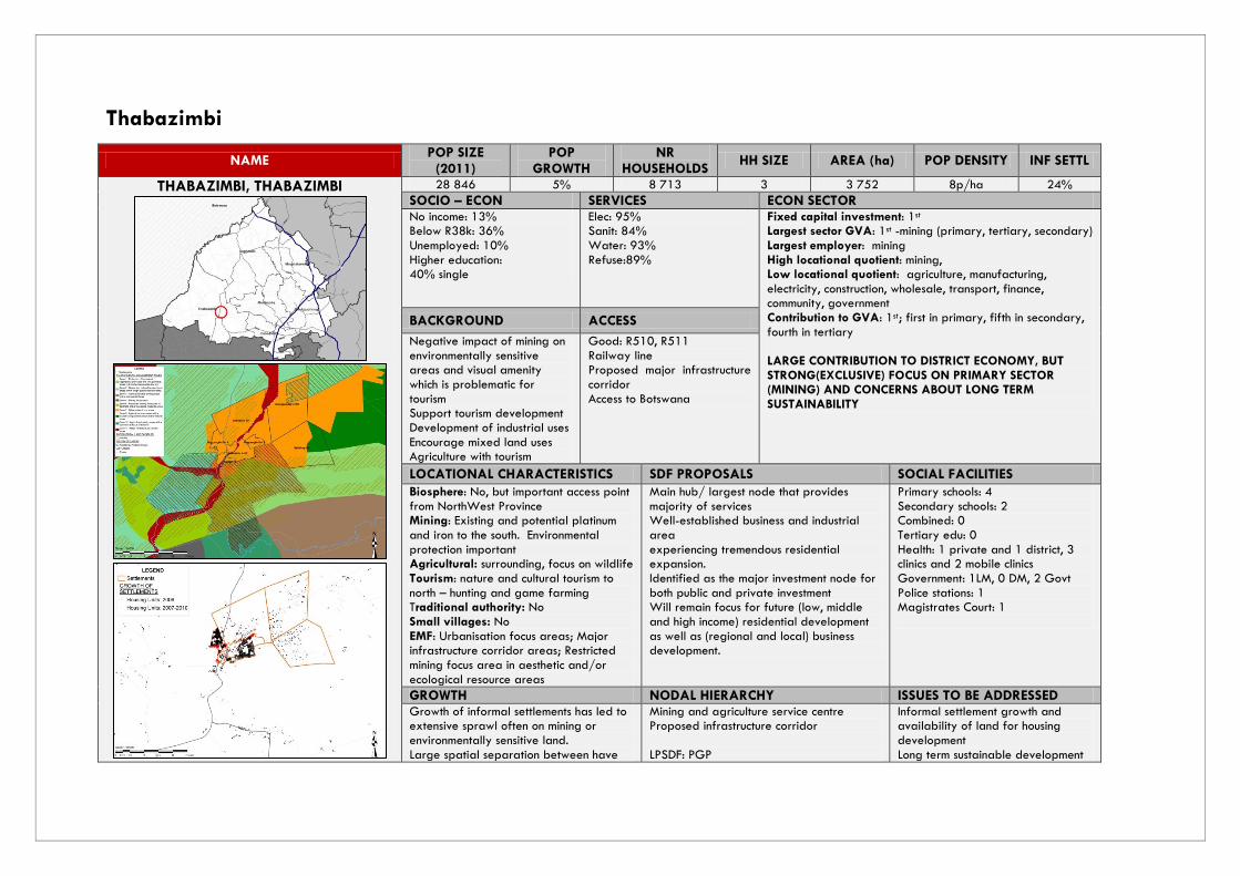
Thabazimbi
NAME POP SIZE
(2011) POP
GROWTH NR
HOUSEHOLDS HH SIZE AREA (ha) POP DENSITY INF SETTL
THABAZIMBI, THABAZIMBI
28 846 5% 8 713 3 3 752 8p/ha 24%
SOCIO – ECON SERVICES ECON SECTOR No income: 13% Below R38k: 36% Unemployed: 10% Higher education: 40% single
Elec: 95% Sanit: 84% Water: 93% Refuse:89%
Fixed capital investment: 1st Largest sector GVA: 1st -mining (primary, tertiary, secondary) Largest employer: mining High locational quotient: mining, Low locational quotient: agriculture, manufacturing, electricity, construction, wholesale, transport, finance, community, government Contribution to GVA: 1st; first in primary, fifth in secondary, fourth in tertiary LARGE CONTRIBUTION TO DISTRICT ECONOMY, BUT STRONG(EXCLUSIVE) FOCUS ON PRIMARY SECTOR (MINING) AND CONCERNS ABOUT LONG TERM SUSTAINABILITY
BACKGROUND ACCESS
Negative impact of mining on environmentally sensitive areas and visual amenity which is problematic for tourism Support tourism development Development of industrial uses Encourage mixed land uses Agriculture with tourism
Good: R510, R511 Railway line Proposed major infrastructure corridor Access to Botswana
LOCATIONAL CHARACTERISTICS SDF PROPOSALS SOCIAL FACILITIES
Biosphere: No, but important access point from NorthWest Province Mining: Existing and potential platinum and iron to the south. Environmental protection important Agricultural: surrounding, focus on wildlife Tourism: nature and cultural tourism to north – hunting and game farming Traditional authority: No Small villages: No EMF: Urbanisation focus areas; Major infrastructure corridor areas; Restricted mining focus area in aesthetic and/or ecological resource areas
Main hub/ largest node that provides majority of services Well-established business and industrial area experiencing tremendous residential expansion. Identified as the major investment node for both public and private investment Will remain focus for future (low, middle and high income) residential development as well as (regional and local) business development.
Primary schools: 4 Secondary schools: 2 Combined: 0 Tertiary edu: 0 Health: 1 private and 1 district, 3 clinics and 2 mobile clinics Government: 1LM, 0 DM, 2 Govt Police stations: 1 Magistrates Court: 1
GROWTH NODAL HIERARCHY ISSUES TO BE ADDRESSED Growth of informal settlements has led to extensive sprawl often on mining or environmentally sensitive land. Large spatial separation between have
Mining and agriculture service centre Proposed infrastructure corridor LPSDF: PGP
Informal settlement growth and availability of land for housing development Long term sustainable development

and have-nots Access to Botswana Provides services to rest of municipality Large number of informal settlements Proposed Long Haul Freight Rail Linkage by Transnet will pass through this area and greatly increase its growth potential overtime
WDSDF: MGP
PROPOSED: DGP
Diversification of economy Visual impact of mining on tourism
Figure 16: THABAZIMBI SPATIAL DEVELOPMENT FRAMEWORK

NAME POP SIZE
(2011) POP
GROWTH NR
HOUSEHOLDS HH SIZE AREA (ha) POP DENSITY INF SETTL
NORTHAM, THABAZIMBI
30 003 11% 8 904 3 5 456.52 5p/ha 44%
SOCIO – ECON SERVICES No income: 19% Below R38k: 26% Unemployed: 13% Higher education: 4%
Elec: 57% Sanit: 52% Water: 56% Refuse: 53%
BACKGROUND ACCESS Second largest town in municipality Delivery of services to surrounding farms and villages Mining central to the town Well-established business sector
Fair: R510 Railway line Main route between Thabazimbi and Rustenburg (P16-2)
LOCATIONAL CHARACTERISTICS SDF PROPOSALS SOCIAL FACILITIES Biosphere: No Mining: mining focus area platinum Agricultural: commercial game and cattle to the south; agricultural priority area to the north – intensive, commercial Tourism: Yes; annual Oppikoppi festival Traditional authority: No Small villages: No EMF: Mining focus areas; Major infrastructure corridor areas
Opportunity to create strong business and residential node Major investment node for private and public sector Will remain the focus for future (low, middle and high income) residential development as well as (regional and local) business development. Due to locality with respect to the surrounding mines, development will most likely focus more on affordable and low-cost residential development with ancillary business development that is mostly focused on the local market.
Primary schools: 5 Secondary schools: 1 Combined: 0 Tertiary edu: 0 Health: 1 Clinic Government: 1 LM, 0 DM, 0 Govt Police stations: 1 Magistrates Court: 1
GROWTH NODAL HIERARCHY ISSUES TO BE ADDRESSED Scattered development due to mining towns Extensive vertical sprawl and some infill densification Proposed Long Haul Freight Rail Linkage by Transnet will pass through this area and greatly increase its growth potential overtime
Major infrastructure corridor LPSDF & LMSDF: MGP WSDF: LSP
PROPOSED MGP
Informal settlement upgrading Beneficiation on supply side Consolidation of scattered settlements Proposal to convert Northam Comprehensive School to be the Technical College to address lack of skills in Thabazimbi


Figure 17: NORTHAM SPATIAL DEVELOPMENT PROPOSALS

NAME POP SIZE
(2011) POP
GROWTH NR
HOUSEHOLDS HH SIZE AREA (ha) POP DENSITY INF SETTL
DWAALBOOM, THABAZIMBI
568 11% 230 2.23 330.77 2p/ha 16%
SOCIO – ECON SERVICES No income: 4% Below R38k: 42% Unemployed: 4% Higher education: 16%
Elec: 74 % Sanit: 60% Water: 37% Refuse: 37%
BACKGROUND ACCESS Mining, agriculture A small town also referred to a mining town with the focal point being the PPC mine. Dwaalboom residents reside in the surrounding farm areas or in PPC houses. It has a various supporting social and business amenities. Thabazimbi provides key specialised services. The farms that are located in and around Dwaalboom also accommodate farm workers.
Limited: D1629, D113, D1649 from Thabazimbi to Dwaalboom to the Derdepoort Border Post into Botswana
LOCATIONAL CHARACTERISTICS SDF PROPOSALS SOCIAL FACILITIES Biosphere: No Mining: Yes Agricultural: Yes, intensive agriculture Tourism: Yes, situated close to Nature reserves Traditional authority: No Small villages: No EMF: Agricultural priority area (intensive commercial)
Smaller nodes with a very limited or no economic base Can possibly establish itself as a tourism support town for this area. There are already various lodges in the area. Strategic route D1629, D113, D1649 to be upgraded to improve connectivity with the rest of the district as well as Botswana.
Primary schools: 2 Secondary schools: 0 Combined: 0 Tertiary edu: 0 Health: 1 Clinic Government: 0 Police stations: 1 Magistrates Court: 1 Periodical Court
GROWTH NODAL HIERARCHY ISSUES TO BE ADDRESSED Delivery of services to surrounds Residents travel to Thabazimbi for specialised services Number of social and business amenities that serve local community and surrounding farms Relatively isolated in terms of surrounding settlements
LSDF & LMSDF: LSP PROPOSAL: LSP
Upgrade of D1629-D113 between Dwaalboom and Dedepoort Border Post Maintain and upgrade services for the surrounding communities

NAME POP SIZE
(2011) POP
GROWTH NR
HOUSEHOLDS HH SIZE AREA (ha) POP DENSITY INF SETTL
LEEUPOORT, THABAZIMBI
1 189 3.6% 415 2.8 297.16 4p/ha 36%
SOCIO – ECON SERVICES No income: 15% Below R38k:45 % Unemployed: 8% Higher education: 9%
Elec: 73% Sanit: 41% Water: 73% Refuse: 30%
BACKGROUND ACCESS Leeupoort is known as a “Holiday Township”. It is one of the few formally proclaimed holiday townships in the Country that has specific eco-life style natural living areas. It was initially established as a private development, but after it experienced financial difficulties the township was taken over by the former Bushveld District Council and thereafter inherited by the Thabazimbi Municipality as a public township. The township is characterised by gravel roads, borehole water, septic tanks with limited boundary fences around dwelling houses and game is roaming freely within the confines of Leeupoort.
Good: R516 between Bela Bela & Thabazimbi (via Koedoeskop)
LOCATIONAL CHARACTERISTICS SDF PROPOSALS SOCIAL FACILITIES Biosphere: to the north of the R516 is the Buffer Zone Mining: Potential mining Agricultural: Game farming Tourism: Eco-Tourism Traditional authority: No Small villages: No EMF: Game and cattle farming areas with a commercial focus
Continue the Eco-Tourism nature of the town and surrounds and Establish more tourism-orientated businesses Concentrate business activity along the R516
Primary schools: 0 Secondary schools: 0 Combined: 0 Tertiary edu: 0 Health: 0 Government: 0 Police stations: 0 Magistrates Court: 0
GROWTH NODAL HIERARCHY ISSUES TO BE ADDRESSED Recreation with a conservation focus The wider area is increasingly being developed for similar styled eco-lifestyle developments Raphuti village is located at Leeupoort Township. A formal township application has already been launched to formalise this area, but proclamation has been drawn out for a number of years. The Provincial Government granted 100 subsidies in favour of this project.
LPSDF: 5th Order Settlement PROPOSAL: LSP
Need for housing in Raphuti Village Poor quality of drinking water Leeupoort and Raphuti experiences environmental degradation and potential health hazards. There is no waste water treatment plant. Paving of roads & developing stormwater drainage system Lack of emergency & medical services Need to improve access to municipal services through satellite offices

Figure 18: LEEUPOORT SPATIAL DEVELOPMENT PROPOSALS
NAME POP SIZE
(2011) POP
GROWTH NR
HOUSEHOLDS HH SIZE AREA (ha) POP DENSITY INF SETTL
KOEDOESKOP, THABAZIMBI
149 No Data No Data No Data 199 1p/ha No Data
BACKGROUND ACCESS
Koedoeskop is a classic farming community with a small-scale business component. The surrounding area is mostly agricultural and utilised as irrigation farming.
Fair: At intersection of R516 to Bela Bela and the R511 to Thabazimbi in the north and Brits to the south
LOCATIONAL CHARACTERISTICS SDF PROPOSALS SOCIAL FACILITIES Biosphere: No, but very close to Transition 1 Zone Mining: No Agricultural: Yes, high potential agriculture along river banks Tourism: Yes, but on a small scale Traditional authority: No Small villages: No EMF: Agricultural priority areas with a commercial focus (intensive)
Provide a low-level service to the farming community in the area.
Primary schools: 2 Secondary schools: 0 Combined: 0 Tertiary edu: 0 Health: 0 Government: 0 Police stations: 0 Magistrates Court: 0
GROWTH NODAL HIERARCHY ISSUES TO BE ADDRESSED No residential expansion is proposed Expected growth of Koedoeskop as a main agricultural node in addition to local school residences, eco-estates and activities related to the new Obaro cooperative opening in the area
PROPOSAL: LSP
Inadequate sanitation Maintenance of roads

Figure 19: KOEDOESKOP SPATIAL DEVELOPMENT PROPOSAL
NAME POP SIZE
(2011) POP
GROWTH NR
HOUSEHOLDS HH SIZE AREA (ha) POP DENSITY INF SETTL
ROOIBERG, THABAZIMBI
2 310 1% 540 4.28 118.3 20p/ha 17%
SOCIO – ECON SERVICES No income: 15% Below R38k:52 % Unemployed: 14% Higher education: 3%
Elec: 96% Sanit: 86% Water: 86% Refuse: 83%
BACKGROUND ACCESS Small rural town originated as mining town. Mining activities ceased. Mostly inhabited by residents involved in local businesses, primarily agricultural, tourist and property related, retired citizens. Surrounding farms accommodate farm workers There is an informal settlement just outside the town
Limited: Favourable location on road D928 that links to main route between Bela-Bela and Thabazimbi.
LOCATIONAL CHARACTERISTICS SDF PROPOSALS SOCIAL FACILITIES Biosphere: Yes, Transition 1 Zone Mining: Potential. Deposits of Tin and Iron. Mine in the town is closed down Agricultural: Yes Tourism: Yes Traditional authority: No Small villages: No EMF: Nature and cultural tourism focus areas within a high quality natural setting
Low Cost Housing project approved for ± 200 new houses Located on one of the main access routes to Marakele, Provincial Road D928 route (needs to be tarred as a main feeder to Park). Establish tourism-orientated businesses at Rooiberg, particularly along the D928
Primary schools: 1 Secondary schools: 0 Combined: 0 Tertiary edu: 0 Health: 1 Clinic Government: 0 Police stations: 1 Magistrates Court: 1Periodical Court
GROWTH NODAL HIERARCHY ISSUES TO BE ADDRESSED Popular tourism investment areas Popularity lies in location close to large number of nature and game reserves (Marakele National Park) Rooiberg is on the main access routes to Marakele National Park will become popular tourist venues Shown development potential based on increased interest in eco-orientated rural residential living Residential development to not be encouraged unless employment can be provided
LPSDF: LSP PROPOSAL: LSP
Affected by undermining due to closed down mine Need for relocation of people living on undermined land Poor quality of drinking water Need for the establishment of a one stop Centre for government services. Waste Water Treatment Works in need of upgrading
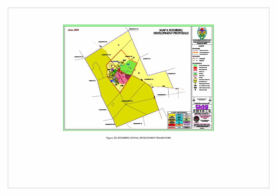
Figure 20: ROOIBERG SPATIAL DEVELOPMENT FRAMEWORK

NAME POP SIZE
(2011) POP
GROWTH NR
HOUSEHOLDS HH SIZE AREA (ha) POP DENSITY INF SETTL
AMANDELBULT, THABAZIMBI
4 372 9.8% 1 038 3 6 044.46 1p/ha 23%
SOCIO – ECON SERVICES No income: 9% Below R38k:17 % Unemployed: 6% Higher education: 8%
Elec: 77% Sanit: 17% Water: 70% Refuse: 72%
BACKGROUND ACCESS Amandelbult is a platinum mining town between Thabazimbi and Northam. Residential area with ancillary land uses including business, social and other erven at the Anglo Platinum Mine. Amandelbult is a fully functional township and totally independent from Thabazimbi Municipality regarding infrastructure services, i.e. water, sanitation, electricity, roads and stormwater.
Good: Situated along the R510 in between Thabazimbi and Northam. The railway line passes through here Railway line
LOCATIONAL CHARACTERISTICS SDF PROPOSALS SOCIAL FACILITIES Biosphere: No Mining: Yes, Platinum Agricultural: No Tourism: No Traditional authority: No Small villages: No EMF: Mining focus areas
Facilitate orderly growth of the settlement Situated along the proposed Transnet Long Haul Freight Rail Linkage and mining focus area. Will greatly increase this area’s development potential
Primary schools: 1 Secondary schools: 0 Combined: 0 Tertiary edu: 0 Health: 1 Hospital Government: 0 Police stations: 0 Magistrates Court: 0
GROWTH NODAL HIERARCHY ISSUES TO BE ADDRESSED Proposed Long Haul Freight Rail Linkage by Transnet will pass through this area and greatly increase its growth potential overtime
PROPOSAL: Mining Town
Facilitating orderly development of the area Levying of refuse removal

NAME POP SIZE
(2011) POP
GROWTH NR
HOUSEHOLDS HH SIZE AREA (ha) POP DENSITY INF SETTL
SWARTKLIP, THABAZIMBI
3 517 0.75% 1 027 3.42 1 114.8 3p/ha 2%
SOCIO – ECON SERVICES No income: 10% Below R38k:20 % Unemployed: 6% Higher education: 16%
Elec: 99% Sanit: 98% Water: 96% Refuse: 97%
BACKGROUND ACCESS Residential area with ancillary land uses including business, social and other erven at the RPM Union Section Mine. Swartklip is a fully functional township and totally independent from Thabazimbi Municipality regarding infrastructure services, i.e. water, sanitation, electricity, roads and stormwater.
Fair: just off the R510 , to the west of Northam Railway line
LOCATIONAL CHARACTERISTICS SDF PROPOSALS SOCIAL FACILITIES Biosphere: No Mining: Yes, Platinum Agricultural: No Tourism: Yes; annual Oppikoppi festival Traditional authority: No Small villages: No EMF: Mining focus areas
Facilitate orderly growth of the settlement Situated near the proposed Transnet Long Haul Freight Rail Linkage and mining focus area. Will greatly increase this area’s development potential
Primary schools: 1 Secondary schools: 0 Combined: 0 Tertiary edu: 0 Health: 1 Hospital, 1 Clinic Government: 0 Police stations: 0 Magistrates Court: 0
GROWTH NODAL HIERARCHY ISSUES TO BE ADDRESSED Proposed Long Haul Freight Rail Linkage by Transnet will pass nearby this area in Northam and greatly increase its growth potential overtime
PROPOSAL: Mining Town
Facilitating orderly development of the area Levying of refuse removal

Mookgophong
NAME POP SIZE
(2011) POP
GROWTH NR
HOUSEHOLDS HH SIZE AREA (ha) POP DENSITY INF SETTL
MOOKGOPHONG, MOOKGOPHONG (previously Naboomspruit)
24 918 30 6 356 4.04 926.55 27p/ha 12%
SOCIO – ECON SERVICES ECON SECTOR No income: 15% Below R38k: 50% Unemployed: 13% Higher education: 5%
Elec: 93% Sanit: 74% Water: 96% Refuse: 93%
Fixed capital investment: 6th: (very low) tertiary, primary, secondary Largest sector GVA: Finance Largest employer: Wholesale High locational quotient: agriculture, transport, finance and government Low locational quotient:, mining, manufacturing, Contribution to GVA: 6th overall and in all sectors VERY SMALL AND SHRINKING ECONOMY. POSSIBLE GROWTH POTENTIAL IN TOURISM AND RETIREMENT
BACKGROUND ACCESS
Agricultural service centre Also serves surrounding mines N1 physically divides Mookgophong Potential development for retirement market
Excellent: N1, R101, R520, R519
Railway line
N1 physically divides the town
LOCATIONAL CHARACTERISTICS SDF PROPOSALS SOCIAL FACILITIES
Biosphere: Transition zones 1 and 2 Mining: Yes Agricultural: agriculture with tourism Tourism: cultural based on high quality natural environment and culture Traditional authority: No Small villages: No EMF: Agriculture focus areas with a tourism component surrounded by natural areas
Activity nodes Development corridors Activity spines Specialised activity areas Densification
Primary schools: 4 Secondary schools: 2 Combined: 0 Tertiary edu: 0 Health: 1 private and 1 provincial, 2 Clinics Government: 1 LM, 0 DM, 2 Govt Police stations: 1 Magistrates Court: 1
GROWTH NODAL HIERARCHY ISSUES TO BE ADDRESSED Vertical sprawl with limited infill densification Still strongly reflects apartheid patterns. Higher income growth took place towards north with slow uptake of erven. Quality of development directly competes with similar developments in Modimolle and Bela Bela. Established residential deteriorating Stagnation of growth of industrial
LPSDF & LMSDF: PGP WDSDF: MGP
PROPOSED: MGP
Continued apartheid structure Declining urban environment Small economic base
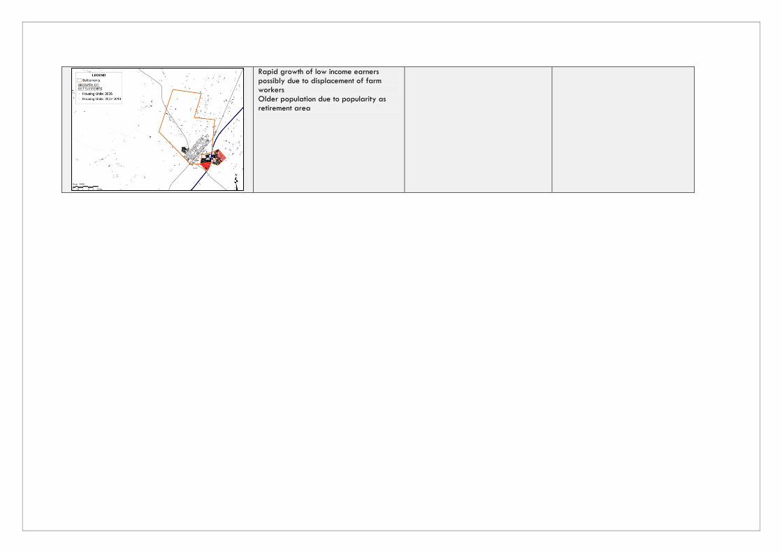
Rapid growth of low income earners possibly due to displacement of farm workers Older population due to popularity as retirement area

Figure 21: MOOKGOPHONG SPATIAL DEVELOPMENT FRAMEWORK

NAME POP SIZE
(2011) POP
GROWTH NR
HOUSEHOLDS HH SIZE AREA (ha) POP DENSITY INF SETTL
ROEDTAN & THUSANG, MOOKGOPHONG
1 183 0.77 343 2.69 142.77 8 p/ha 4%
SOCIO – ECON SERVICES No income: 11% Below R38k: 61% Unemployed: 16% Higher education: 4%
Elec: 92% Sanit: 87% Water: 82% Refuse: 87%
BACKGROUND ACCESS Limited function as regional service centre. Large number of vacant stands and a substantial number of land uses, mainly business, outside the proclaimed town, on farm land. There has been a decrease in crop farming activities on the Springbok Flats in favour of ranching and game farming activities.
Very good: N11, R101, R519
LOCATIONAL CHARACTERISTICS SDF PROPOSALS SOCIAL FACILITIES Biosphere: No Mining: Potential Agricultural: Agriculture priority area (intensive commercial) Tourism: No Traditional authority: No Small villages: No EMF: Agricultural priority areas with a commercial focus (intensive)
Affordable housing should not be perpetuated beyond current housing initiatives. Once town has established economic base, additional housing developments can be considered. Growth must be restricted within the development boundary.
Primary schools: 1 Secondary schools: 0 Combined: 1 Tertiary edu: 0 Health: 1 Clinic, 1 Mobile Clinic Government: 0 Police stations: 1 Magistrates Court: 1 Periodical Court
GROWTH NODAL HIERARCHY ISSUES TO BE ADDRESSED Small stagnant settlement with more indication of decay than growth Main focus should be on developing rural agricultural support centre, comprising agricultural industries, transportation services, warehouses etc.
LMSDF: MGP WDSDF: NO DESIGNATION
PROPOSAL: LSP
Focus on developing as an agricultural support centre Illegal industrial and commercial on surrounding farm portions Address access to water issues