SESSION # ONE BASIC PRINCIPLES OF GROUNDWATER HYDROLOGY Dr ... · BASIC PRINCIPLES OF GROUNDWATER...
38
SESSION # ONE SESSION # ONE BASIC PRINCIPLES OF BASIC PRINCIPLES OF GROUNDWATER HYDROLOGY GROUNDWATER HYDROLOGY Dr. Amjad Aliewi Dr. Amjad Aliewi House of Water and Environment House of Water and Environment (HWE) (HWE) 28/5/2007 28/5/2007
Transcript of SESSION # ONE BASIC PRINCIPLES OF GROUNDWATER HYDROLOGY Dr ... · BASIC PRINCIPLES OF GROUNDWATER...

SESSION # ONESESSION # ONE
BASIC PRINCIPLES OF BASIC PRINCIPLES OF GROUNDWATER HYDROLOGYGROUNDWATER HYDROLOGY
Dr. Amjad AliewiDr. Amjad AliewiHouse of Water and EnvironmentHouse of Water and Environment
(HWE)(HWE)
28/5/200728/5/2007

11 GroundwaterGroundwaterGroundwater is water that exists in the pore spaces and Groundwater is water that exists in the pore spaces and fractures in rock and sediment beneath the Earthfractures in rock and sediment beneath the Earth’’s surface. s surface. It originates as a rainfall or snow, and then moves through It originates as a rainfall or snow, and then moves through the soil into the groundwater system, where it eventually the soil into the groundwater system, where it eventually makes its way back to the surface streams, lakes, or oceans.makes its way back to the surface streams, lakes, or oceans.
Groundwater makes up about 1% of the water on the Groundwater makes up about 1% of the water on the Earth (most water is in oceans)Earth (most water is in oceans)
But, groundwater makes up to 35 times the amount of But, groundwater makes up to 35 times the amount of water in lakes and streams.water in lakes and streams.
Groundwater occurs everywhere beneath the EarthGroundwater occurs everywhere beneath the Earth’’s s surface, but is usually restricted to depth less than about surface, but is usually restricted to depth less than about 750 meters.750 meters.
The volume of groundwater is equivalent to a 55The volume of groundwater is equivalent to a 55--meter meter thick layer spread out over the entire surface of the thick layer spread out over the entire surface of the Earth.Earth.
Ground water is our most important source of Ground water is our most important source of freshwater in the West Bankfreshwater in the West Bank

22 Origin of GroundwaterOrigin of Groundwater
Practically groundwater originates as surface water which Practically groundwater originates as surface water which will enter the ground surface as natural or artificial will enter the ground surface as natural or artificial recharge.recharge.
Connate GroundwaterConnate Groundwater is a water in marine sediments at the is a water in marine sediments at the time of deposition of sedimentary rocks.time of deposition of sedimentary rocks.
Magmatic WaterMagmatic Water (in or from Magma). (in or from Magma).
Metamorphic WaterMetamorphic Water (is or has been with rocks during their (is or has been with rocks during their metamorphism).metamorphism).
Meteoric WaterMeteoric Water (is or recently from the atmosphere).(is or recently from the atmosphere).

33 Occurrence of GroundwaterOccurrence of Groundwater
To understand the ways in which groundwater occurs, it is To understand the ways in which groundwater occurs, it is needed to think about the ground and the water properties.needed to think about the ground and the water properties.
PorosityPorosity, which is the property of a rock of possessing pores , which is the property of a rock of possessing pores or voids.or voids.Saturated and unsaturated zones.Saturated and unsaturated zones.
PermeabilityPermeability, which is the ease with which water can flow , which is the ease with which water can flow through the rock.through the rock.
AquiferAquifer, which is a geologic formation sufficiently porous to , which is a geologic formation sufficiently porous to store water and permeable enough to allow water to flow store water and permeable enough to allow water to flow through them in economic quantities.through them in economic quantities.
Storage coefficientStorage coefficient, which is the volume of water that an , which is the volume of water that an aquifer releases from or takes into storage per unit surface aquifer releases from or takes into storage per unit surface area of aquifer per unit change in the component of head area of aquifer per unit change in the component of head normal to surface normal to surface

44 Groundwater and Hydrological CycleGroundwater and Hydrological Cycle
The hydrological cycle is the most fundamental principle of The hydrological cycle is the most fundamental principle of hydrology.hydrology.
The driving force of the circulation is derived from the The driving force of the circulation is derived from the radiant energy received from the sun.radiant energy received from the sun.
Water Water evaporatesevaporates. it travels into the air and becomes part . it travels into the air and becomes part of a cloud. It falls down to earth as of a cloud. It falls down to earth as precipitationprecipitation. Then it . Then it evaporates again.evaporates again.
Precipitation creates Precipitation creates runoffrunoff that travels over the ground that travels over the ground surface and helps to fill lakes and rivers. surface and helps to fill lakes and rivers.
It also It also infiltratesinfiltrates or or percolatespercolates or moves downward through or moves downward through openings in the soil to replenish aquifers under the ground.openings in the soil to replenish aquifers under the ground.

Some places receive more precipitation than others, these Some places receive more precipitation than others, these areas are usually close to oceans or large bodies of water areas are usually close to oceans or large bodies of water that allow more water to evaporate and form clouds. Other that allow more water to evaporate and form clouds. Other areas receive less. Often these areas are far from water or areas receive less. Often these areas are far from water or near mountains.near mountains.
As clouds move up and over mountains, the water vapor As clouds move up and over mountains, the water vapor condenses to form precipitation and freezes.condenses to form precipitation and freezes.
Figure 1 Figure 1 shows a schematic representation of the hydrologic shows a schematic representation of the hydrologic cycle cycle

Figure 1Figure 1 Schematic representation of the hydrologic cycleSchematic representation of the hydrologic cycle

55 Types of Geologic Formations and AquifersTypes of Geologic Formations and Aquifers
1.1. AquiferAquifer
AnAn aquifer is a layer of rock beneath the earth's surface which aquifer is a layer of rock beneath the earth's surface which contains water which can be drawn off for human consumption. Thecontains water which can be drawn off for human consumption. Therock can berock can be nonnon--consolidated materials such as sand or gravel. It consolidated materials such as sand or gravel. It can also be consolidated materials such as fractured limestone ocan also be consolidated materials such as fractured limestone or r sandstone. There aresandstone. There are also aquifers of oil, natural gas and saltwater. also aquifers of oil, natural gas and saltwater. There are three types of aquifers: There are three types of aquifers: confinedconfined, , unconfinedunconfined, or , or perchedperched. .
Confined Aquifer (Artesian Aquifer)Confined Aquifer (Artesian Aquifer)A confined aquifer is one in which the water is being hA confined aquifer is one in which the water is being held eld
under pressure which is greater than the atmospheric under pressure which is greater than the atmospheric pressure. The water is between two pressure. The water is between two confining layersconfining layers. . This This forces the water to rise. forces the water to rise. Unconfined Aquifer (water table aquiferUnconfined Aquifer (water table aquifer))
An unconfined aquifer is one in which the water is undeAn unconfined aquifer is one in which the water is under r atmospheric pressure and only partially filled. Here the only atmospheric pressure and only partially filled. Here the only confining layer is on the bottom.confining layer is on the bottom.Perched AquiferPerched Aquifer
A perched aquifer is one where a small body of groundwaA perched aquifer is one where a small body of groundwater ter is separated from the main aquifer by a confining layer is separated from the main aquifer by a confining layer

Notes: Notes:
Confining layerConfining layer is a geological unit with low permeability.is a geological unit with low permeability.
Potentiometric surfacePotentiometric surface is a surface representative of the is a surface representative of the level to which water will rise in a well cased to the aquifer. level to which water will rise in a well cased to the aquifer. If it is above the land surface a flowing artesian well will If it is above the land surface a flowing artesian well will flow. flow.
Figure 2 Figure 2 illustrates aquifer types.illustrates aquifer types.

Figure 2 Figure 2 Schematic crossSchematic cross--section of aquifer types section of aquifer types

2.2. AquitardAquitard
An aquitard is a partly permeable geologic formation.An aquitard is a partly permeable geologic formation. It It transmits water at such a slow rate that the yield is transmits water at such a slow rate that the yield is insufficientinsufficient. Pumping by wells is not possible. For . Pumping by wells is not possible. For example, sand lenses in a clay formation will form an example, sand lenses in a clay formation will form an aquitard aquitard
3.3. AquicludeAquiclude
An aquiclude is composed of rock or sediment that acAn aquiclude is composed of rock or sediment that acts ts as a barrier to groundwater flow. Aquicludes are made up as a barrier to groundwater flow. Aquicludes are made up of of low porosity and low permeabilitylow porosity and low permeability rock/sediment such rock/sediment such as shale or clay.as shale or clay.
4.4. AquifugeAquifuge
An aquifuge is a geologic formation which doesnAn aquifuge is a geologic formation which doesn’’t have t have interconnected pores. It is neither porous nor permeable. interconnected pores. It is neither porous nor permeable. Thus Thus it can neither store water nor transmit itit can neither store water nor transmit it. Examples . Examples of aquifuge are rocks like basalt, granite, etc. without of aquifuge are rocks like basalt, granite, etc. without fissures.fissures.

66 Water Table and Piezometric SurfaceWater Table and Piezometric Surface
1.1. Water TableWater Table
Water table is the surface of water level in an unconfined Water table is the surface of water level in an unconfined aquifer at which the pressure is atmospheric.aquifer at which the pressure is atmospheric.It is the level at which the water will stand in a well It is the level at which the water will stand in a well drilled in an unconfined aquifer.drilled in an unconfined aquifer.The water table fluctuates whenever there is a recharge The water table fluctuates whenever there is a recharge or an outflow from the aquifer. or an outflow from the aquifer. In fact, the water table is constantly in motion adjusting In fact, the water table is constantly in motion adjusting its surface to achieve a balance between the recharge its surface to achieve a balance between the recharge and the out flow.and the out flow.Generally, the water table follows the topographic Generally, the water table follows the topographic features and is high below ridges and low below valleys.features and is high below ridges and low below valleys.

2.2. Perched Water TablePerched Water Table
It occurs when a small water body is separated from It occurs when a small water body is separated from the main groundwater body by a relatively small the main groundwater body by a relatively small impermeable stratum.impermeable stratum.Wells drilled below the perched water table upto the Wells drilled below the perched water table upto the small impervious stratum yield very small quantity of small impervious stratum yield very small quantity of water and soon go dry.water and soon go dry.
3.3. Piezometric SurfacePiezometric Surface
The water in a confined aquifer is under pressure. The water in a confined aquifer is under pressure. When a well is drilled in a confined aquifer, the water When a well is drilled in a confined aquifer, the water level in it is above the top of aquifer. level in it is above the top of aquifer. The piezometric surface is an imaginary surface to The piezometric surface is an imaginary surface to which the water level would rise if piezometers were which the water level would rise if piezometers were inserted in the aquifer.inserted in the aquifer.Thus, it indicates the pressure of the water in the Thus, it indicates the pressure of the water in the aquifer.aquifer.Hence, a piezometric surface is the water table Hence, a piezometric surface is the water table
equivalent of the confined aquifer.equivalent of the confined aquifer.
Figure 3 Figure 3 illustrates the concepts of water table and illustrates the concepts of water table and piezometric surface.piezometric surface.

Figure 3Figure 3 Water table and Piezometric SurfaceWater table and Piezometric Surface

77 Aquifer PropertiesAquifer Properties
1.1. PorosityPorosity
Porosity (n) is the percentage of rock or soil that iPorosity (n) is the percentage of rock or soil that is void s void of material. The larger the pore space or the greater their of material. The larger the pore space or the greater their number, the higher the porosity and the larger the waternumber, the higher the porosity and the larger the water--holding capacity. It is defined mathematically by the holding capacity. It is defined mathematically by the equation:equation:
100 xVVn v=
where,n is the porosity (percentage)Vv is the volume of void space in a unit volume of earth materials (L3, cm3 or m3)V is the unit volume of earth material, including both voids and solids (L3, cm3 or m3)

In sediments or sedimentary rocks the porosity depends on In sediments or sedimentary rocks the porosity depends on grain size, the shape of the grains, the degree of sorting and grain size, the shape of the grains, the degree of sorting and the degree of cementationthe degree of cementation. In rocks, the porosity depends . In rocks, the porosity depends upon the upon the extent, spacing and pattern of cracks and extent, spacing and pattern of cracks and fracturesfractures..
WellWell--rounded coarserounded coarse--grained sediments grained sediments usually have usually have higher porosityhigher porosity than finethan fine--grained sediments, because the grained sediments, because the grain dongrain don’’t fit together well (see t fit together well (see Figure 4Figure 4) )
Poorly sorted sediments (sediments contains a mixture of Poorly sorted sediments (sediments contains a mixture of grain sizes) grain sizes) usually have lower porosityusually have lower porosity because the finebecause the fine--grained fragments tend to fill the open spaces (see grained fragments tend to fill the open spaces (see Figure Figure 55).).
Since cements tend to fill in the pore space, Since cements tend to fill in the pore space, highly highly cemented sedimentary rocks have lower porosity cemented sedimentary rocks have lower porosity (see (see Figure 6Figure 6).).

Figure 4Figure 4 Porosity of wellPorosity of well--rounded coarse sediments vs. rounded coarse sediments vs. fine grained sediments fine grained sediments

Figure 5Figure 5 Poorly sorted sedimentsPoorly sorted sediments

Figure 6Figure 6 Highly cemented sedimentary rocksHighly cemented sedimentary rocks

In igneous and metamorphic rocks porosity In igneous and metamorphic rocks porosity is usually lowis usually lowbecause the minerals tend to be intergrown, leaving little because the minerals tend to be intergrown, leaving little free space. Higher fractured igneous and metamorphic free space. Higher fractured igneous and metamorphic rocks, however, could have high porosity (see rocks, however, could have high porosity (see Figure 7Figure 7).).
The porosity of sediments is affected by the shape of the The porosity of sediments is affected by the shape of the grains. Wellgrains. Well--rounded grains may be almost perfect spheres, rounded grains may be almost perfect spheres, but many grains are very irregular. They can be shaped like but many grains are very irregular. They can be shaped like rods, disks, or books. Sphererods, disks, or books. Sphere--shaped grains will pack more shaped grains will pack more tightly and have less porosity than particles of other shapes. tightly and have less porosity than particles of other shapes. The fabric or orientation of the particles, if they are not The fabric or orientation of the particles, if they are not spheres, also influences porosity (see spheres, also influences porosity (see Figure 8Figure 8).).
Porosity can range from Porosity can range from zero to more than 60%.zero to more than 60%.
Recently deposited sediments Recently deposited sediments have higher porosityhave higher porosity..
Dense crystalline rock or highly compacted soft rocks such Dense crystalline rock or highly compacted soft rocks such as shale as shale have lower porosity.have lower porosity.

Figure 7Figure 7 Igneous and metamorphic rocks textures Igneous and metamorphic rocks textures

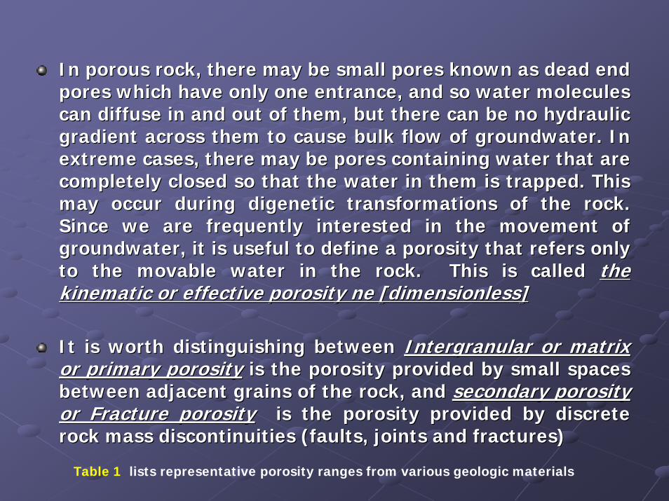
In porous rock, there may be small pores known as dead end In porous rock, there may be small pores known as dead end pores which have only one entrance, and so water molecules pores which have only one entrance, and so water molecules can diffuse in and out of them, but there can be no hydraulic can diffuse in and out of them, but there can be no hydraulic gradient across them to cause bulk flow of groundwater. In gradient across them to cause bulk flow of groundwater. In extreme cases, there may be pores containing water that are extreme cases, there may be pores containing water that are completely closed so that the water in them is trapped. This completely closed so that the water in them is trapped. This may occur during digenetic transformations of the rock. may occur during digenetic transformations of the rock. Since we are frequently interested in the movement of Since we are frequently interested in the movement of groundwater, it is useful to define a porosity that refers only groundwater, it is useful to define a porosity that refers only to the movable water in the rock.to the movable water in the rock. This is called This is called the the kinematic or effective porosity ne [dimensionless]kinematic or effective porosity ne [dimensionless]
It is worth distinguishing between It is worth distinguishing between Intergranular or matrix Intergranular or matrix or primary porosityor primary porosity is the porosity provided by small spaces is the porosity provided by small spaces between adjacent grains of the rock, and between adjacent grains of the rock, and secondary porosity secondary porosity or Fracture porosityor Fracture porosity is the porosity provided by discrete is the porosity provided by discrete rock mass discontinuities (faults, joints and fractures)rock mass discontinuities (faults, joints and fractures)
Table 1 lists representative porosity ranges from various geologic materials

Table 1Table 1 Range of values of porosityRange of values of porosity
Formation n (%)
Unconsolidated deposits
GravelSandSiltClay
Rocks
Fractured basaltKarst limestoneSandstoneLimestone, dolomiteShaleFractured crystalline rockDense crystalline rock 0 – 5
25 - 4025 - 5035 - 50
40 - 705 - 505 - 505 - 300 - 200 – 100 - 10

2.2. Specific Yield (SSpecific Yield (Syy))
Specific yield (SSpecific yield (Syy) is the ratio of the volume of water that drains ) is the ratio of the volume of water that drains from a saturated rock owing to the attraction of gravity (or by from a saturated rock owing to the attraction of gravity (or by pumping from wells) to the total volume of the saturated pumping from wells) to the total volume of the saturated aquifer. It is defined mathematically by the equation:aquifer. It is defined mathematically by the equation:
Where,Where,SSyy is the specific yield (percentage)is the specific yield (percentage)VVww is the volume of water in a unit volume of earth materials (Lis the volume of water in a unit volume of earth materials (L3, cm3 or m3)3, cm3 or m3)V is the unit volume of earth material, including both voidV is the unit volume of earth material, including both voids and solids (L3, s and solids (L3,
cm3 or m3)cm3 or m3)
All the water stored in a water bearing stratum cannot be All the water stored in a water bearing stratum cannot be drained out by gravity or by pumping, because a portion of the drained out by gravity or by pumping, because a portion of the water is rigidly held in the voids of the aquifer by molecular awater is rigidly held in the voids of the aquifer by molecular and nd surface tension forces (see surface tension forces (see Table 2Table 2).
100*VVwS y =
).

Table 2Table 2 Specific yield in percentSpecific yield in percent
Formation Sy (range) Sy (average)
ClaySandy claySiltFine sandMedium sandCoarse sand Gravelly sandFine gravelMedium gravelCoarse gravel
0 - 53 - 123 - 19
10 - 2815 - 3220 - 3520 - 3521 - 3513 - 2612 - 26
27
1821262725252322

3.3. Specific Retention (SSpecific Retention (Srr))
Specific retention (SSpecific retention (Srr) is the ratio of the volume of water that ) is the ratio of the volume of water that cannot be drained out to the total volume of the saturated cannot be drained out to the total volume of the saturated aquifer. Since the specific yield represents the volume of aquifer. Since the specific yield represents the volume of water that a rock will yield by gravity drainage, with specific water that a rock will yield by gravity drainage, with specific retention the remainder, the sum of the two is equal to retention the remainder, the sum of the two is equal to porosity (see porosity (see Figure 9Figure 9).).
The specific yield and specific retention depend upon the The specific yield and specific retention depend upon the shape and size of particle, distribution of pores (voids), and shape and size of particle, distribution of pores (voids), and compaction of the formation.compaction of the formation.
The specific retention increases with decreasing grain size.The specific retention increases with decreasing grain size.
It should be noted that it is not necessary that a soil with a It should be noted that it is not necessary that a soil with a high porosity will have a high specific yield because that soil high porosity will have a high specific yield because that soil may have low permeability and the water may not easily drain may have low permeability and the water may not easily drain out. For example, clay has a high porosity but low specific out. For example, clay has a high porosity but low specific yield because its permeability is low.yield because its permeability is low.
yr SSn +=

Figure 9Figure 9 Specific retentionSpecific retention

4.4. Coefficient of permeability (Hydraulic conductivity) (K)Coefficient of permeability (Hydraulic conductivity) (K)
Permeability is the ease with which water can flow in a soil masPermeability is the ease with which water can flow in a soil mass or a s or a rock. The coefficient of permeability (K) is equal to the discharock. The coefficient of permeability (K) is equal to the discharge per rge per unit area of soil mass under unit hydraulic gradient. Because thunit area of soil mass under unit hydraulic gradient. Because the e discharge per unit area is equal to the velocity, the coefficiendischarge per unit area is equal to the velocity, the coefficient of t of permeability has the dimension of the velocity [L/T]. it is usuapermeability has the dimension of the velocity [L/T]. it is usually lly expressed as cm/s, m/s, m/day, etc. The coefficient of permeabilexpressed as cm/s, m/s, m/day, etc. The coefficient of permeability is ity is also called hydraulic conductivity.also called hydraulic conductivity.
The coefficient of permeability (K) depends on the proThe coefficient of permeability (K) depends on the properties of both perties of both porous medium and fluid. It can be expressed as,porous medium and fluid. It can be expressed as,
µρgCdK m
2
=
where,C is the shape factor which depends upon the shape, particle size and
packing of the porous media.dm is the mean particle size (d50).ρ is the mass density.g is the acceleration due to gravity.

Another coefficient of permeability, called Another coefficient of permeability, called intrinsic permeability (k),intrinsic permeability (k), is sometimes is sometimes used. The intrinsic permeability depends upon the porous medium used. The intrinsic permeability depends upon the porous medium and is independent and is independent of the properties of the fluid. It is usually expressed as,of the properties of the fluid. It is usually expressed as,
The intrinsic permeability k has the dimensions of [L2] and is uThe intrinsic permeability k has the dimensions of [L2] and is usually expressed in cm2 sually expressed in cm2 or Darcy, where 1 Darcy = 0.987 * 10or Darcy, where 1 Darcy = 0.987 * 10--8 cm2.8 cm2.
The intrinsic permeability is The intrinsic permeability is rarely used in groundwater hydrologyrarely used in groundwater hydrology, but this term is , but this term is very popular in the petroleum and natural gas industries. very popular in the petroleum and natural gas industries.
The intrinsic permeability is also called the The intrinsic permeability is also called the absolute permeabilityabsolute permeability..
The rate of groundwater flow is controlled by the two propertiesThe rate of groundwater flow is controlled by the two properties of the rock, of the rock, porosity porosity and permeability.and permeability.
Low porosity usually results in low permeabilityLow porosity usually results in low permeability, but , but high porosity does not high porosity does not necessarily imply high permeabilitynecessarily imply high permeability. It is possible to have a highly porous rock with . It is possible to have a highly porous rock with little or no interconnections between pores. A good example of alittle or no interconnections between pores. A good example of a rock with high rock with high porosity and low permeability is a vesicular volcanic rock, wherporosity and low permeability is a vesicular volcanic rock, where the bubbles that once e the bubbles that once contained gas give the rock a high porosity, but since these holcontained gas give the rock a high porosity, but since these holes are not connected to es are not connected to one another the rock has low permeability.one another the rock has low permeability.
Typical values of hydraulic conductivity for unconsolidated and Typical values of hydraulic conductivity for unconsolidated and hard rocks are given in hard rocks are given in Table 3Table 3 respectively which are taken from Marsily [1986].respectively which are taken from Marsily [1986].
2mCdk =

Table 3Table 3 Hydraulic conductivity for unconsolidated and hard rocksHydraulic conductivity for unconsolidated and hard rocks
Medium K (ms-1)
Unconsolidated deposits
Coarse gravelSands and gravelsFine sands, siltsClay, shale, glacial
Hard Rocks
Dolomitic limestoneWeathered chalkUnweathered chalkLimestoneSandstoneGranite, gneiss, compact basalt
10-2 – 10-1
10-5 – 10-2
10-9 – 10-5
10-13 – 10-9
10-5 – 10-3
10-5 – 10-3
10-9 – 10-6
10-9 – 10-5
10-10 – 10-4
10-13 – 10-9
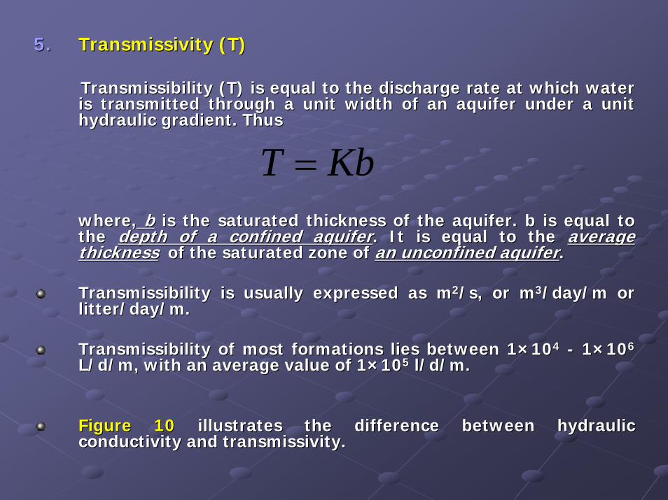
5.5. Transmissivity (T)Transmissivity (T)
Transmissibility (T) is equal to the discharge rate at which watTransmissibility (T) is equal to the discharge rate at which water er is transmitted through a unit width of an aquifer under a unit is transmitted through a unit width of an aquifer under a unit hydraulic gradient. Thus hydraulic gradient. Thus
where,where, bb is the saturated thickness of the aquifer. b is equal to is the saturated thickness of the aquifer. b is equal to the the depth of a confined aquiferdepth of a confined aquifer. It is equal to the . It is equal to the average average thicknessthickness of the saturated zone of of the saturated zone of an unconfined aquiferan unconfined aquifer..
Transmissibility is usually expressed as mTransmissibility is usually expressed as m22/s, or m/s, or m33/day/m or /day/m or litter/day/m.litter/day/m.
Transmissibility of most formations lies between 1Transmissibility of most formations lies between 1××101044 -- 11××101066
L/d/m, with an average value of 1L/d/m, with an average value of 1××101055 l/d/m.l/d/m.
Figure 10 Figure 10 illustrates the difference between hydraulic illustrates the difference between hydraulic conductivity and transmissivity.
KbT =
conductivity and transmissivity.
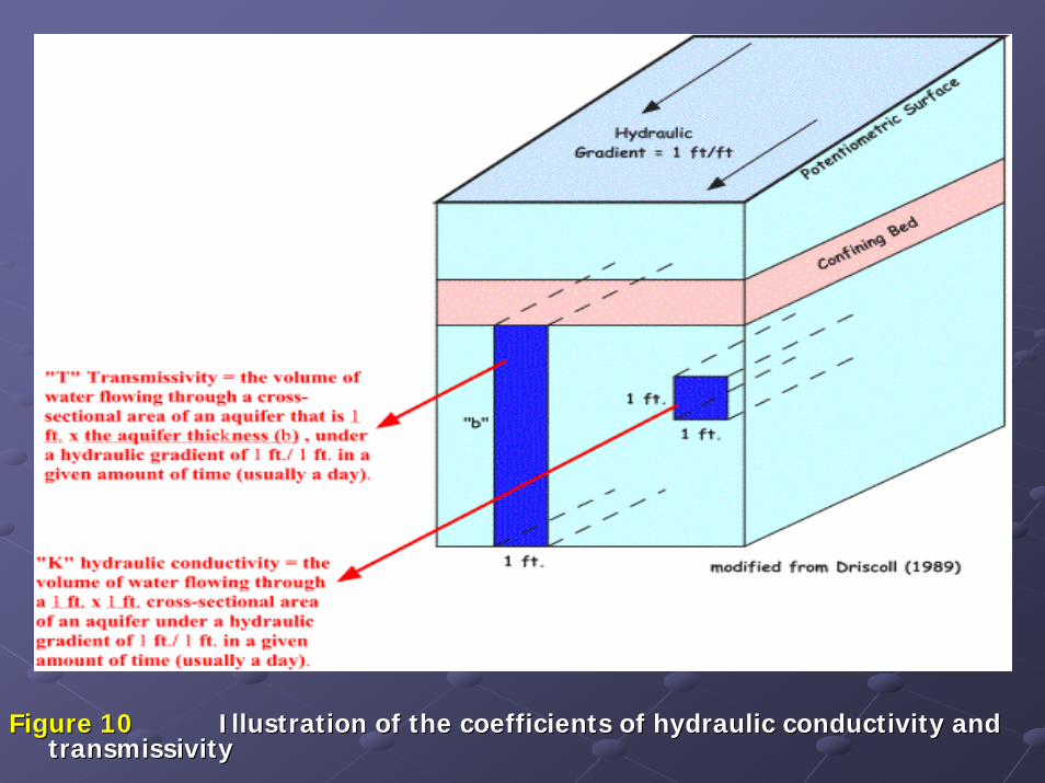
Figure 10Figure 10 Illustration of the coefficients of hydraulic conductivity and Illustration of the coefficients of hydraulic conductivity and transmissivitytransmissivity

6.6. Storage coefficient (S)Storage coefficient (S)
Storage coefficient (S) is the volume of water released from Storage coefficient (S) is the volume of water released from storage, or taken into storage, per unit of aquifer storage areastorage, or taken into storage, per unit of aquifer storage areaper unit change in head.per unit change in head.
The storage coefficient is also called The storage coefficient is also called StorativityStorativity..
The storage coefficient is The storage coefficient is a dimensionlessa dimensionless as it is the ratio of the as it is the ratio of the volume of water released from original unit volume.volume of water released from original unit volume.
The value of the storage coefficient usually lies between The value of the storage coefficient usually lies between 11××1010--55
–– 11××1010--33, with an average value of , with an average value of 11××1010--44..
In In unconfined aquifersunconfined aquifers, , Storativity is the same as the specific Storativity is the same as the specific yieldyield of the aquifer.of the aquifer.
In confined aquifer, In confined aquifer, Storativity is the result of compression of Storativity is the result of compression of the aquifer and expansion of the confined waterthe aquifer and expansion of the confined water when the head when the head (pressure) is reduced during pumping.(pressure) is reduced during pumping.

The transmissivity and storage coefficients are especially The transmissivity and storage coefficients are especially important because they important because they define the hydraulic characteristics define the hydraulic characteristics of a waterof a water--bearing formationbearing formation. The coefficient of . The coefficient of transmissivity indicates how much water will move through transmissivity indicates how much water will move through the formation, and the coefficient of storage indicates how the formation, and the coefficient of storage indicates how much can be removed by pumping or draining. If these two much can be removed by pumping or draining. If these two coefficients can be determined for a particular aquifer, coefficients can be determined for a particular aquifer, predictions of great significance can usually be made. Some predictions of great significance can usually be made. Some of these are:of these are:
Drawdown in the aquifer at various distances from a pumped well.Drawdown in the aquifer at various distances from a pumped well.Drawdown in a well at any time after pumping starts.Drawdown in a well at any time after pumping starts.How multiple wells in a small area will affect one another.How multiple wells in a small area will affect one another.Efficiency of the intake portion of the well.Efficiency of the intake portion of the well.Drawdown in the aquifer at various pumping rates.Drawdown in the aquifer at various pumping rates.

7.7. Specific Storage (SSpecific Storage (Sss))
Specific Storage (Ss) is the storage coefficient per unit Specific Storage (Ss) is the storage coefficient per unit saturated thickness of the aquifer. Thus, saturated thickness of the aquifer. Thus,
bSSs =
Where, b is the thickness of aquifer.
The specific storage is usually expressed as cm-1 or m-1.For most aquifers, the specific storage is about 1×10⁻⁷ m-1.
Table 4 shows the values of specific storage for given values of aquifercompressibility assuming porosity equals to 15 %.

Table 4Table 4 Values of specific storage for given values of aquifer Values of specific storage for given values of aquifer compressibility assuming porosity equal to 15 % (After Younger, compressibility assuming porosity equal to 15 % (After Younger, 1993)1993)

THANK YOUTHANK YOU


![[hydrology] groundwater hydrology - david k. todd (2005).pdf](https://static.fdocuments.in/doc/165x107/577c77961a28abe0548cb0b1/hydrology-groundwater-hydrology-david-k-todd-2005pdf.jpg)