SESSION NO. 3 Title Opinions - Minnesota Department of ... · SESSION NO. 3 Title Opinions . 2 ......
54
1 SESSION NO. 3 Title Opinions
Transcript of SESSION NO. 3 Title Opinions - Minnesota Department of ... · SESSION NO. 3 Title Opinions . 2 ......

1
SESSION NO. 3
Title Opinions

2
Table of Contents:
Chapter 1: History………………………..……………………………….……………………3
Chapter 2: Definition of Title Opinion..….…….…………………………………………......7
Chapter 3: Ordering Title Opinions….…………..………………………………………….22
Chapter 4: Interpreting the Legal Description.…….………………….……………………31
Chapter 5: Who utilizes the Title Opinion?…………………………..……………………..51

3
Chapter 1
History
Just like an automobile, all real property has title but it is far more complex. Where did
this concept stem from? American real property law has its foundation from the Middle
Ages and the feudal system. Land was a valuable asset and wars were often fought
over it. In 1066, William the Conqueror invaded England and claimed all of the land.
He had a survey completed of England
and parts of Wales that was recorded in
the “Doomsday Book”. It was an
assessment of each landholder and the
amount of their land and livestock to
determine its worth and the amount it
had been taxed.
To control his new kingdom, he set up the feudal system, meaning that all the land was
held by the monarch. Use of the land was granted to lords. The lords would then
contract with the commoners or tenants, giving them rights or estates to use the land in
exchange for goods and services. This is also known as tenure and ranged from
serving as a knight to giving a specified amount of the annual crop. There were a
variety of tenures. The fee simple, like today, had the most freedom even allowing the
tenant to convey the estate. Fee tail estate meant that the tenure could only be passed
on to a lineal descendant and if none existed would revert back to the lord. Life estates
were also granted and automatically reverted to the lord after the tenants’ death. There

4
also was the concept of escheat in which the land reverted back to the lord if there was
a death of the heirs or the tenant committed a felony.
The feudal system evolved over the centuries but it was concept that the British took
with them as they spread throughout the world, including the colonies in North America
that later fought for independence in 1775 and formed the United States of America.
Modern times and Title
How the estate is acquired is the title or the means by which a person has just
possession of a property. Instruments or documents are used to transfer the ownership
from one party to the other. The condition of the title is found by analyzing these

5
instruments to determine who owns the real property and if there are others that have
an interest or right to it. There are different means for obtaining property:
1. Title by public grant such as a patent from the United States.
2. Title by a private grant such as a deed from another party.
3. Title by a will from a deceased party.
4. Title by descent from someone that didn’t have a will.
5. Title by involuntary alienation such as foreclosure or bankruptcy.
6. Title by adverse possession or unwritten agreement.
7. Title by eminent domain.
8. Title by the property reverting to the state (escheat).
9. Title by dedication, such as streets dedicated in a subdivision plat.
10. Title with the element of estoppel.
11. Title by accretion, or land built up by the action of water.
Rights are the attributes that one has in the property,
also known as the bundle of rights. Like a bundle of
sticks, each stick is a specific right, such as the
mineral, water, and timber rights. An individual can
retain a specific right when conveying property or
acquire a specific right and not the entire bundle.
An individual can also place a lien on another’s property. A lien is a charge against
property whereby the property is made security for the payment of a debt. These can
cloud the title, meaning that there are undesirable issues with the real estate. It is
favorable to acquire real estate with clear title. Don Goedken (former OLM Right of
Way Attorney) used to say, “MnDOT is not in the business of fixing title”, if there are
problems with a title, MnDOT has acquisition methods such as eminent domain to
bypass the extensive process required to clear title and the court will grant us clear title
of only the area we need for transportation purposes.
Easements are an interest in land that is granted by the owner to another party for a
specific purpose, for instance to have an electric transmission line cross their land.
There are various types of easements, and can either be tied to an individual or to a
specific parcel. A person may have a drive wayeasement over their neighbor’s
property, this easement would transfer with the property if sold unless stated otherwise.
MnDOT’s right of way easements are in the category of easement in gross, meaning
that it is attached to a party not to a parcel of land.

6
A patent (records available at the BLM General Land Office Records website: www.glorecords.blm.gov)

7
Chapter 2
Definition of Title Opinion By: Danielle Holder
(Right of Way Attorney, Metro)
What is a Title Opinion?
A title opinion states the condition of the title or
the ownership of a specific parcel of real estate
and of the encumbrances to which it is subject.
It is based on the interpretation of instruments
recorded in various county offices such as the
Recorders, Registrars, Court Administration,
etc. The term ‘owner’ includes all persons with
any interest in the property subject to a taking.
(Rock County Courthouse)
The title opinion should be completed in
accordance with the Minnesota Title
Standards (a book by the Minnesota
State Bar Association). This book was
first considered in 1941 by the Section of
Real Property Lay of the Hennepin
County Bar Association and adopted by
the Board of Governors of Minnesota
State Bar Association in 1946. They
have been used consistently for the past
55 years.

8

9
The Marketable Title Act from Minnesota State Statute 541.023 created the ‘40 year
standard’. This applies to abstract property and allows the title examiner to disregard
many of the defects in the title and the older interests that haven’t been noticed in the
records in the past 40 years or in the actual possession. Whether or not the search is
limited to 40 years depends on the location and circumstances. If discrepancies are
found, further research may need to be done or the title may need to be continued. To
continue a title, re-submit it to the Legal unit in Central Office with a request for
additional research.

10
The Real Estate Manual is drafted by the Legal and Property Management Unit in the
Office of Land Management. The most recent version was compiled by Don Goedken
in 2012. It was created for the Field Title Investigators but it is also a helpful resource.
‘It provides a general discussion of Minnesota real estate concepts’. After the title
opinion is received, the Field Title Report is prepared. It is a supplement to the title
opinion that fully identifies all parties of interest, the basis for their interests, the
occupancy of the property and any physical factors that may affect its acquisition.
Copies of the manual can be requested from the Legal and Property Management Unit.
Title Research
Minnesota has two systems for maintaining records of real estate transactions, abstract
and Torrens. The abstract system has been in place since the first transfer of
ownership upon statehood and the grant of the original patent being the first record for a
particular parcel of land. All other documents affecting the title should have been filed
with the County Recorder, including mortgages, conveyances, wills, deeds, easements,
etc… An abstract of title is the summary of all the conveyances, listing the names of the
parties of the land and the agreements arranged to show the continuity of ownership, or
the chain of title. The research is completed by looking at the tract index at the County
Recorder’s office. Some counties have better records and all have slightly different
methods for accessing and organizing the documents. The purpose of the County
Recorder is to record, protect, secure and preserve the documentation of land title.
Land is one of the most valuable assets a citizen may possess. They also maintain
records of the financing statements for land, military service discharge records and
vitals. Records can date back to 1855 (Minnesota was admitted to statehood in 1858).
(Tract Index books)

11
The Torrens title system is the registration of the title to the land, not the evidence of
such a title. It is a system under which, upon the land owner’s application, the court
may, after appropriate proceedings, direct the issuance of a certificate of title. With
some exceptions, this certificate is conclusive as to the applicant’s estate in land. After
registration, all deeds and documents affecting the property are duly registered. This
system was named after its author, Sir Robert Torrens. It was first introduced in South
Australia in 1857. Torrens title includes the guarantee of sufficiency of title. At the time
of first registration under this system there is a quiet title action on the property, giving a
new starting point to the chain of title and eliminating the need for maintaining previous
records. Torrens has the main advantage that ownership and possessions are assured.
(From the book: ‘Definitions of Surveying and Associated Terms’)

12
If a tract of land has both Torrens and abstract, MnDOT policy is to not cover both on
the same title opinion.

13
Legal Description
The description added to the title opinion is from the last deed of record for abstract
property or from the Certificate of Title for Torrens property. The title opinion description
may not include the entire description found on the deed or certificate of title. The
background research was only preformed for the area requested and only that portion
should be spotted.
The description may also be manufactured. These are created for gap/overlap tracts
and for areas where the deed was cut into smaller pieces. There should be a note on
the title opinion identifying that it is a manufactured title and a note on the second page
describing the reason for the manufactured description.

14
The title opinion will not cover adjacent land owned by the same owner. However the
Market Data should include the information for the additional property. If additional land
is described on the Market Data it should be included in the parent tract but not added
to the title since there is no taking.
Ownership
Fee or Fee Simple Absolute – This is the “owner” to be entered into REALMS and on
the caption blocks.
Individuals: Joint Tenants, Tenants in
Common, Spousal Interests
Corporations
Partnerships
Limited Liability Companies
Trusts – the name of the trust should
be added
Common Interest Communities – the name of the association should be put into
the caption block.
Tax Forfeit – if it is still held by the State, the caption block should read: State of
Minnesota in trust for the taxing district
Other interests you may see on the front of the
title opinion:
Life Estate – Person has interest in property for
a period of time measured by a specified
lifetime.

15
Contract for Deed (purchaser) – the party is purchasing the property from the fee
owner on installment. The fee owner is listed on the caption block.
Record Fee – the person’s name is appearing of record as the owner even
though we have evidence that the title has transferred.
2nd page of the Title Opinion:

16
Easements – Interest in land in possession of another that entitles the easement
holder limited use, enjoyment or benefit of the land on which it exists.
o Appurtenant easement – Benefits a piece of property (the dominant
estate) usually by an adjoining property. Passes with the title to the
dominant estate. The property on which it is located is the servient estate.
Example: A driveway
o Easement in gross – Benefits a person or party.
Example: utility and right of way easements
o Blanket Easement or specific – Blanket easements are always affected
and put in the caption block.
o Prescriptive Easement – Not noted in the records but has been
established by usage over time (unrecorded easements).
o License or Permit – Not an easement but often used for utilities
o Affected vs. Not Affected:
All affected easements are added to the caption block on the
workmap
The Right of Way Technician is responsible for marking up
easements on the back of the title.
The Attorney’s Condition of Title (ACOT) is based on this
information
Mark the affected easement documents with ‘affected’
across the top.
o Easement on the Deed or Certificate of Title but not on the title opinion:
Could have been released
It could apply to a different tract on the deed or Torrens Certificate
Other reasons include that it expired or added in error
Other documents may be
depicted on the Half
Section maps but are not
listed in the title. They
should be obtained if
possible; they may contain
information for laying out
roads or other useful
information. Subdivision
plats may also identify
easements that were not
listed on the title.

17
Declarations (for Condominium plats) may also contain easements and can help clarify
information on the plat. Resolutions (made by governing officials) may contain
information about street vacations. County Parcel Identification Numbers (PIN or PID)
should not used to identify parcels. They may have not been spotted correctly in the
County GIS map or may include additional land.
Road Easements can be created in the following ways:
Dedicated per subdivision plat (Minnesota State Statute 505). Read the
dedication on the plat.

18
Town Roads established pursuant to Minnesota State Statute 164.07
County Roads established pursuant to Minnesota State Statute 163.11
Street and Alley openings by cities pursuant to Minnesota State Statute 430.02

19
Right of Way established by use or common law dedication, including those
established pursuant to Minnesota State Statute 160.05. This is commonly
referred to as the ‘six year statute’.
Roadways can also be condemned, gifted or purchased in fee or easemet.
Gaps and Overlaps
Gaps and overlaps are common problems with land descriptions. A gap is where a strip
of land that the adjoining titles do not cover. A new title for the gap will have to be
created, tracing back to when the gap occurred and excepting out the parcels that
created the gap. It is helpful to create an exhibit showing the adjoining titles shaded
and manufacturing a possible legal description of the area. An overlap occurs when it
appears that more than one party have an interest in the same parcel. These situations
are handled on an individual basis. If the same party owns the overlapping tracts, it is
not considered an overlap.
20
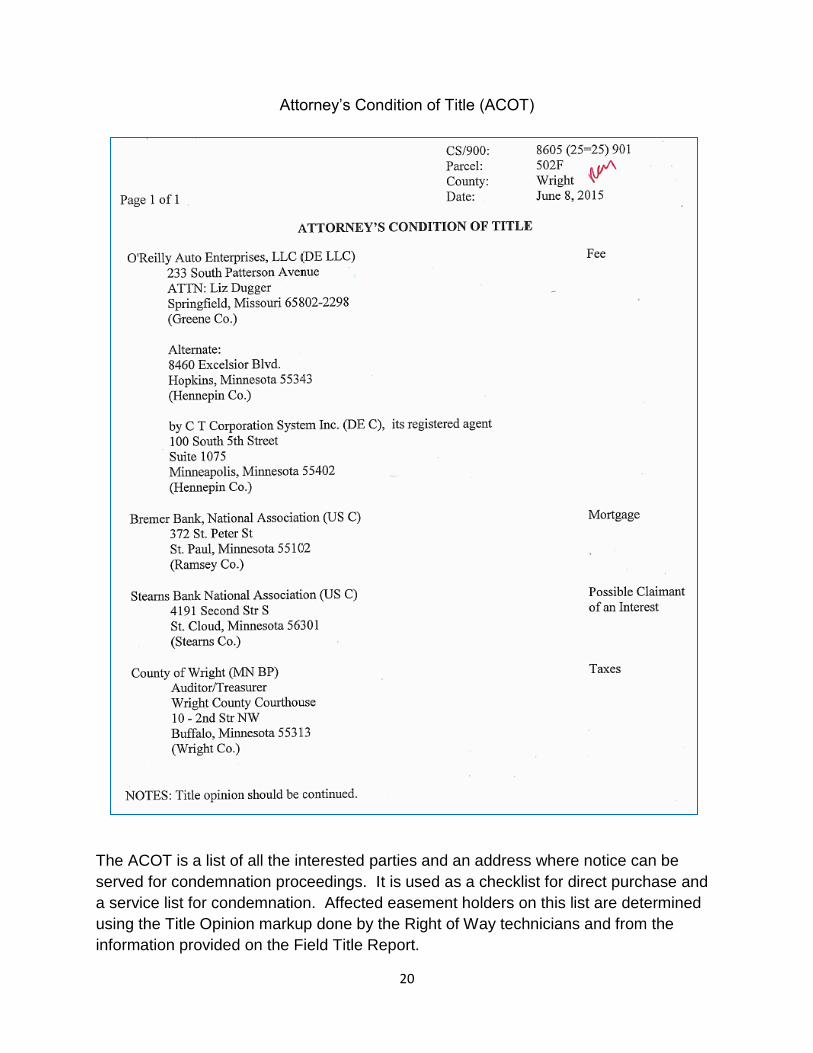
Attorney’s Condition of Title (ACOT)
The ACOT is a list of all the interested parties and an address where notice can be
served for condemnation proceedings. It is used as a checklist for direct purchase and
a service list for condemnation. Affected easement holders on this list are determined
using the Title Opinion markup done by the Right of Way technicians and from the
information provided on the Field Title Report.

21
Updated Title Opinions
There are a variety of reasons that title opinions may have to be updated. Projects get
delayed or the Right of Way group ordered them early to get a jump start on a project.
Regardless of the reason, the titles should not be older than 6 months. Also if there is
knowledge that a transfer was made, then the title should be updated to reflect that. If
there is a change, REALMS should be updated.

22
Chapter 3
Ordering Title Opinions By: Samantha Juneau
(Legal and Property Management Unit Supervisor, OLM)
Proposed Acquisition
The proposed acquisition is determined from the location of the construction limits. This
is a line that the design group feels the construction equipment will not cross. After this
line is established, the Right of Way group makes a determination of how much land will
need to be acquired and whether it will be in fee or easement.
This line may not be available at the point in time the titles will need to be ordered. A
footprint of some kind will have to be approximated to identify the proposed takings of
land that titles will need to be created for. These requests are submitted to the Legal
and Property Management Unit in the Office of Land Management.
The preferred way to identify the property to be acquired is by using Half Section maps.
These are prepared by the County Surveyor. Not all counties have these available.

23

24
When Half Section maps are not available, Final Right of Way maps will suffice. Make
sure that it is the most current map for that highway. Also print off enough area that the
Public Land Survey information is visible (Section, Township and Range). Only the
proposed acquisition areas are desired, it is not necessary to plot the entire final map if
only a portion has a proposed taking. It is also helpful if the plot is to scale and identify
the approximate location.
Many of the Counties have a GIS
viewer available with a tax
identification number (PIN or PID),
but this isn’t the preferred method for
requesting titles. There are
limitations on ordering titles this way.
The legal descriptions are often
inaccurate and you will only get the
title for that specific id. You may get
more or less then what is needed. If it
is used, provide a print of the records
and highlight the description, have
one map with all the parcels, include
a map with and without the aerial and
provide as much information as
possible.

25
Example:

26
Marking Areas
Mark only the area where titles are needed.
It is not necessary to highlight the entire
parcel. Also, don’t mark areas that are
outside of the Half Section maps. Only mark
the road if title to it is needed for acquiring
underlying fee.
When marking, do not shade the entire
location, but outline it in red. The area
needs to close and if you know the
distances, add it to the map.
For this example a map of the city
of St. James was used to request
titles because Half Section maps
are not available and there are no
final right of way maps.

27
Requests
Limit the number of titles per request to 30 or less.
Be as accurate as possible.
Add the name and phone number of the person requesting the titles, not the
Right of Way Engineer.
Include the Letting Date of the project.
Use the forms in REALMS (make sure you add the correct county)
Only one county per request.
After completing the new title order in REALMS, fill out form TO1000. This is the
Attorneys Opinion of Title Request. Then send the form by interoffice mail, along with
the title request maps, to the Legal and Property Management Unit supervisor (currently
is Samantha Juneau).

28
Form TO1000 – Attorneys
Opinion of Title Request
The Title Order No.
should be the number that
was populated in the
REALMS entry.

29
Form TO1004: Title Order Cover
Sheet
This form should be attached to
the title request map. Verify that
the correct template was
selected. The REALMS # should
match the number populated in
REALMS for the new title order
(see page 27).
Time Savers
Request all the titles needed for the area in one request.
Send additional information if you have it:
o Old Titles (from existing parcel files)
o Neighboring titles
o Tax information from the county’s website
It’s better to order more title than not enough.
Re-Ordering Titles
Don’t re-request titles. Ask if you are not sure.
Spot the titles as soon as possible. The vendors have a contract that expires
quickly.
If Gaps are found:
o Draft out the titles that are available and show the gap.
o Manufacture a legal description for the gap.
o Explain why there is a gap.

30
Consultants
To find the list of prequalified Title Services Contractors:
Http://www.dot.state.mn.us/consult/

31
Chapter 4
Interpreting the Legal Description By: Svjetlana Kojic
(Senior Land Surveyor, Metro)
Documents that should be part of the parcel package:
Title Opinion, Field Title Report, Market Data Report and Parcel Sketch
All affected easements. Read the easement documents to verify if they are
affected or not. On the title mark the affected easements with ‘A’ and not
affected easements with ‘NA’.
o In addition:
Check the Field Title Report, since it may have a note about an
easement that is not listed on the title.
Check the Half Section maps for any easements on the affected
parcel that may not be listed on the title.
Street vacation documents listed on the front and/or back of title
o In addition:
Check the Half Section maps since there may be vacated
streets/alleys within the parcel that are not listed on the title.
All the documents referenced on the title.
o For example:
‘…to the north line of property as described in doc no. 5015096…’
‘…all that part of the Northwest Quarter…as described in Torrens
Certificate 49652…’
‘…except that part of the subject property as described in document
no. 1056509…’

32
Wattles’ Definition of a Legal Description:
‘It is an outline of a tract of land using an orderly grouping of words which delineates the
piece of land by itself’.
Structure of Land Description:
A description usually has four parts: Caption, Body, Qualifying Clause and Augmenting
Clause.
Caption identifies the general area in which the land being described is situated.
‘That part of the Northwest Quarter of Section 12, Township 115 North, Range 21 West
of the 5th Principal Meridian, Hennepin County, described as follows…’
Body identifies a particular tract in the general area described in the caption.
‘Commencing at the northwest corner of said Section 12; thence southerly along the
west line of said Section 12 a distance of 1112.78 feet to the point of beginning; thence
northerly deflecting to the left 115 degrees 10 minutes 22 seconds for a distance of 400
feet…’
Qualifying Clause takes something away from the area described in the caption or
body.
‘…excepting therefrom…’ or ‘…subject to…’
Augmenting Clause adds something to the area being conveyed.
‘…together with (or also)…’
Terms and Definitions
Adjacent - means near or close, but it is often used to mean contiguous.
Adjoining – means attached or contiguous.
Each side – means on both sides.
Except or excepting therefrom – means cut out, excluded.

33
Subject to – means reservation or restriction, not an exception.
Reserved – means keeping a certain right.
Straight line – means the shortest distance between two points.
Line – in a description, it does not necessarily mean a straight line.
More or less – means approximately.
Parallel with a line – running at a constant distance from the base line.
Projection – is the extension of a line.
Continuation – is the extension of a line.
Said – means preceding, used to refer to something again without having to give all the
details.
Commencing at – tracts or lines do not start at the point commencement. This is used
when starting at a known tie to get to the point of beginning. There could be a series of
calls before the point of beginning.
Beginning at – starting point of a line or tract.
Perpendicular – at right angles to a straight line or to the tangent of a curve at a given
point.
Bounded – contained within a certain boundary or limited to an area.
Easement – a right of use over the property of another.
On file and of record – refer to a legal document (plat, deed, etc.) that has been filed
and recorded at courthouse.
Thread – The thread of a road is a line midway between the side lines. The thread of a
stream is the line equidistant between the two banks of a stream.
Thalweg – The deepest part of a channel of a river or stream.

34
Meander Line – The traverse of a body of water for the purpose of determining the size
and location of the body of water. It does not represent the land boundary.
Deflection angle – the horizontal
angle measured from the
prolongation of the preceding line,
right or left, to the following line.
Angle to the right – the
horizontal angle
measured clockwise from
the preceding line to the
following line.
Angle to the left – the horizontal
angle measured counter-clockwise
from the preceding line to the
following line.

35
General direction calls –
given in descriptions to make
the description easier, give
the reader a sense of
direction and to fix direction of
travel.
Public Land
Survey System
(PLSS) -

36
A diagram of the Aliquot parts (or standard subdivisions) of a Section:
This is a zoomed in area of
a GLO (Government Land
Office) original plat. It is of
Section 21 and is not a
standard subdivision
because of the lake. The
red numbers identify the
Government Lot number.
These plats can be found
at:
www.mngeo.state.mn.us/gl
o/Index.htm
or
www.glorecords.blm.gov/de
fault.aspx

37
Below are a few of the common terms for curves:
Types of Land Descriptions
Subdivision of a section
o ‘The East Half of Section 13, Township 114 North, Range 21 West…’
Recorded Plat
o ‘Lot 7, Block 12 of Riverview Addition…’’
Metes and Bounds Description

38
o Bounds, Metes and Bounds, Division Line, Strip, Linear, Area,
Proportional Parts
Examples:
A. Bounds

39
B. Metes and Bounds
Description A
That part of the Northwest Quarter of the Northeast Quarter, Section 12, Township 116
North, Range 22 West of the 5th Principal Meridian, described as follows:
Beginning at the northwest corner of said Northwest Quarter of the Northeast
Quarter; thence southerly, along the west line of said Northwest Quarter of the
Northeast Quarter, a distance of 405.00 feet; thence southeasterly, deflecting to
the left 65 degrees 00 minutes 00 seconds, a distance of 610.00 feet; thence
northeasterly, deflecting to the left 60 degrees 00 minutes 00 seconds, a distance
of 400.00 feet; thence northeasterly and easterly a distance of 349.07 feet along
a tangential curve to the right having a radius of 400.00 feet and a central angle
of 50 degrees 00 minutes 00 seconds; thence easterly, tangent to said curve, to
the east line of said Northwest Quarter of the Northeast Quarter; thence northerly
along said east line to the northeast corner of said Northwest Quarter of the
Northeast Quarter; thence westerly along the north line of said Northwest Quarter
of the Northeast Quarter to the point of beginning.

40
Description B
That part of the Northwest Quarter of the Northeast Quarter of Section 12, Township
116 North, Range 22 West of the 5th Principal Meridian, Hennepin County, Minnesota,
described as follows:
Beginning at the north quarter of said Section 12; thence South, assumed
bearing, along the west line of said Northwest Quarter of the Northeast Quarter
405.00 feet; thence South 65 degrees 00 minutes 00 seconds East 610.00 feet;
thence North 55 degrees 00 minutes 00 seconds East 400.00 feet; thence
northeasterly and easterly along a tangential curve, concave to the south, radius
400 feet, central angle 50 degrees 00 minutes 00 seconds, 349.07 feet; thence
South 75 degrees 00 minutes 00 seconds East along tangent to the east line of
said Northwest Quarter of the Northeast Quarter; thence northerly along said
east line to the northeast corner of said Northwest Quarter of the Northeast
Quarter to the point of beginning.
C. Division Line
Description A
That part of Outlot A, LAKE ADDITION, according to the recorded plat thereof, lying
northerly of a line described as follows:
Commencing at the northwest corner of said outlot; thence southerly, along the
west line of said outlot, a distance of 250.00 feet to the beginning of the line to be
described; thence southeasterly, deflecting to the left 75 degrees 00 minutes 00

41
seconds, a distance of 125.00 feet; thence easterly a distance of 447.68 feet along a
tangential curve concave to the north having a radius of 570.00 feet and a central angle
of 45 degrees 00 minutes 00 seconds; thence easterly a distance of 368.61 feet along a
reverse curve concave to the south having a radius of 640.00 feet and a central angle of
33 degrees 00 minutes 00 seconds; thence easterly, tangent to said reverse curve, a
distance of 70.00 feet, more or less, to the intersection with the east line of said outlot,
and said line there terminating.
Description B
That part of Outlot A, LAKE ADDITION, according to the recorded plat thereof, lying
northerly of the following described line:
Beginning at a point on the west line of said Outlot A 250.00 feet south of the
northwest corner of said outlot; thence South 75 degrees 00 minutes 00 seconds
East 125.00 feet (said west line has an assumed bearing of South); thence
easterly along a tangential curve, concave to the north, radius point of reverse
curvature; thence easterly along 640.00 foot radius curve concave to the south,
central angle 33 degrees 00 minutes 00 seconds, 368.1 feet; thence South 87
degrees 00 minutes 00 seconds East 70 feet, more or less, to the east line of
said outlot and there terminating.
D. Division Line

42
Description A
That part of Lot 3, Block 6, FREEMAN’S ADDITION, according to the record plat
thereof, lying northerly of “Line 1” and southeasterly of “Line 2.” Said “Line 1” and “Line
2” are described as follows:
“Line 1” is a line parallel with and distant 80.00 feet northerly from the south line
of said lot, as measured at a right angle to said north line, and its westerly
prolongation.
“Line 2” is a line drawn from the point of intersection of said “Line 1” with the
southwesterly line of said Lot 3 to a point on the northeasterly line of said Lot 3,
distant 135.00 feet northwesterly, measured along said northeasterly line, from
the northeast corner of said Lot 3.
E. Strip
Description A
A 100.00 foot easement for highway purposes over, under and across the Northwest
Quarter of the Northeast Quarter of Section 8, Township 117 North, Range 22 West of
the 5th Principal Meridian. The center line of said easement is described as follows:
Commencing at the southwest corner of said Northwest Quarter of the Northeast
Quarter; thence northerly, along the west line of said Northeast Quarter of the Northeast
Quarter a distance of 500.00 feet; thence westerly, deflecting to the left 99 degrees 00
minutes 00 seconds, a distance of 100.00 feet to the beginning of the center line to be

43
described; thence easterly, deflecting 180 degrees 00 minutes 00 seconds, a distance
of 600.00 feet; thence easterly a distance of 500.00 feet along a tangential curve
concave to the south having a radius of 1909.86 feet and a central angle of 15 degrees
00 minutes 00 seconds; thence easterly, tangent to said curve, a distance of 400.00
feet, and said center line there terminating.
Together with a strip of land 25.00 feet in width southerly of and adjoining the above
described strip and lying between the west line of said Northwest Quarter of the
Northeast Quarter and a line drawn at a right angle to said center line from a point
thereon distant 250.00 feet easterly from the west line of said Northwest Quarter of the
Northeast Quarter as measured along said center line.
And together with a strip of land 25.00 feet in width northerly of and adjoining the above
described 100.00 foot strip which lies easterly of a line normal to the curve in said
center line at a point on said center line 100.00 feet easterly, measured along said
center line, from the beginning to said curve and westerly of a line normal to said curve
at its easterly terminus.
F. Linear, Area and Proportional Parts Descriptions:
1. ‘The east 100 feet of the Southeast Quarter of the Southeast Quarter of
Section 15…’
This parcel is computed by a line that is 100 feet westerly of and parallel with the east
line of Southeast Quarter of the Southeast Quarter.
2. ‘The east one acre of the Southeast Quarter of the Southeast Quarter of
Section 15…’
This parcel is located by computing a line that is parallel with the east line of the
Southeast Quarter of the Southeast Quarter and located so that the exact acreage
called for is contained in the tract.
3. ‘The East Half of the Southeast Quarter of the Southeast Quarter of Section
15…’
This parcel is located by connecting points located at the mid-points of the north and
south boundary lines of the Southeast Quarter of the Southeast Quarter.

44
G. Linear
Description A
The most easterly 50.00 feet of Lot 2, Block 3, WHITE’S ADDITION, according to the
recorded plat thereof.
H. Linear

45
Description A
That part of the southwesterly 35.00 feet of Lot 1, Block 18, TRANSIT ADDITION,
according to the plat thereof on file and of record in the office of the County Recorder,
Hennepin County, Minnesota, lying southeasterly of the northeasterly prolongation of
the northwesterly line of Lot 8 in said Block 18.
I. Area
Description A
The northerly 10 acres of the Northeast Quarter of the Southwest Quarter of Section 10,
Township 117 North, Range 26 West of the 5th Principal Meridian. The southerly line of
said 10 acres bears South 80 degrees 00 minutes 00 seconds West, assuming the
north line of said Northeast Quarter of the Southwest Quarter bears East.

46
J. Area
Description A
The north 10 acres of the Southeast Quarter of the Southeast Quarter of Section 10,
Township 116 North, Range 22 West of the 5th Principal Meridian. The south line of
said 10 acres is parallel with the north line of said Southeast Quarter of the Southeast
Quarter.
K. Proportion

47
Description A
The East 1/3 of the area of the Northwest Quarter of the Southwest Quarter of Section
11, Township 118 North, Range 24 West of the 5th Principal Meridian. The west line of
said East 1/3 shall be parallel with the east line of said Northwest Quarter of the
Southwest Quarter.
L. Proportion
Description A
The East 1/3 of the Southwest Quarter of the Southeast Quarter of Section 10,
Township 118 North, Range 23 West of the 5th Principal Meridian, as determined by the
proportionate width thereof.
Meaning of calls on the Deed
Westerly (easterly, northerly or southerly) of highway or road – means
extending westerly (easterly, northerly or southerly) from the center line and not
from the right of way line of the highway (road).
Westerly (easterly, northerly or southerly) of right of way line of highway or
road – means extending westerly (easterly, northerly or southerly) from the right
of way line.

48
To the highway or road – means to the center line of the highway (road). If the
distance of the line is given and a call is made to the road, ignore the distance,
the line will stop at the center line of that road (the center line as described at the
time of recording).
o ‘…thence 75 degrees 25 minutes 30 seconds for 650.86 feet to Mill
Street…’ (to the center line of Mill Street)
To the south (north, west or east) right of way line of highway or road –
means to the south (north, west or east) right of way line of that road or highway.
If the distance of the line is given and a call is made to the road right of way,
ignore the distance, the line will stop at the right of way line of that road or
highway.
o ‘…thence 85 degrees 10 minutes 02 seconds for 650.86 feet to the
southerly right of way line of Mill Street…’
o ‘…thence 85 degrees 10 minutes 02 seconds for 350 feet to the northerly
right of way line of highway 95…’
To a point/monument – means the line goes to that specified point/monument;
ignore the direction and distance.
o ‘…thence on an azimuth of 81 degrees 50 minutes 02 seconds for 450.86
feet to the southwest corner of Section 5, Township 29 North, Range 20
West…’
o ‘…thence on an azimuth of 90 degrees 18 minutes 20 seconds for 350
feet to a point on the south line of Section 5, Township 29 North, Range
20 West, said County, distant 650 feet east of southwest corner of said
Section 5…’
Along a plat boundary or a line means just that. That line is not necessarily a
straight line; it can contain a few calls. If a call is made ‘along plat boundary’ and
distances and azimuths are given between B corners, compare them with those
on the signed plat. If there is a discrepancy use the plat data.
o ‘…to Right of Way Boundary Corner B28 as shown on Minnesota
Department of Transportation Right of Way Plat No. 10-22 as the same is
on file and of record in the office of the County Recorder in and for said
County; thence on an azimuth of 269 degrees 19 minutes 54 seconds
along the boundary of said plat for 40.00 feet to Right of Way Boundary
Corner B65…’

49
o ‘…to the intersection with Line 1 described below; thence along said
Line 1; thence on an azimuth of 15 degrees 15 minutes 10 seconds for
520.11 feet…’
Line 1. Beginning at the southwest corner of Section 12, Township 115
North, Range 21 West of the 5th Principal Meridian, Hennepin
County, Minnesota; thence northeasterly on an azimuth of 20
degrees 12 minutes 01 seconds for 250.15 feet; thence on an
azimuth of 50 degrees 45 minutes 25 seconds for 260 feet and
there terminating.’
Examples:
A.

50
See N ½ SEC 03, T 029 R 20 (Half Section map handout)
B.
See S ½ SEC 33, T 030, R 20 (Half Section map handout)

51
Chapter 5
Who utilizes the Title Opinion? By: Dawna Butcher
(Senior Land Surveyor, OLM)
Who utilizes the Title Opinion?
Platting and Description Unit – Beyond the Title Opinion:
The Platting and Description Units review the title opinion and the attached
documents before writing narrative descriptions for non-platted projects and verify the
information depicted on the Acquisition Plats. This review is typically done at the later
stages of preparation to acquire land. However preliminary plat reviews are an option
and has detected potential issues giving the district time to find a solution in advance of
deadlines. Both Units review Acquisition Plats, but only the Description Unit reviews the
title opinion for non-platted projects.
For projects that are not platted, narrative descriptions are written. The
description included on the title opinion is used to describe the taking. Copies of the
deeds to verify the description are desired. Occasionally the description on the title
opinion is modified; this is frowned upon. Due to the nature of a legal description it is
possible to create ambiguities and they miss pertinent data.
Title Opinion:
Acquisition Description:

52
Common calls in the description that create issues:
Call to the road
o it is a call to the centerline as located and established on the date of the
recorded instrument unless the right of way is specifically called for
Except
o The land is excluded/excepted out of the description
Subject to
o The land is included in the description but has an easement over it
Common discrepancies found in the title opinion
“See Attached Exhibit A”
o More than one Exhibit A in the supporting documents or the document
wasn’t included.
Duplicating the title
o Having additional paragraphs covering the same location area. It is
redundant and there could be discrepancies between the various
descriptions.
In the Plat Manual there is a list of suggested information for the preparation of plats
including:
Parcel deeds from parcel files or final certificates from
condemnation files. Recorded and unrecorded right of way
easements for the local roads (County, Township, City)
Copies of recorded and unrecorded public and private easements
Copies of all adjoining recorded and unrecorded plats and maps
Copies of all title opinions
The manual also requests that all affected recorded and unrecorded public and private
easements be depicted on the plat with the width and document number, except public
easements created by a subdivision plat. They can be easily located by the subdivision
plat on which they were created. Examples of the documentation include:
Recorded and unrecorded public and Private Easements
o Pipeline, Utility, Driveways, Tile Lines, Sewer, Water, etc…
Recorded and unrecorded Right of Way documents for roads
o County, Township and City
Recorded and unrecorded plats and maps
o Auditor’s plats, Subdivision Plats, Railroad Lots, Registered Land Surveys
Miscellaneous
o Judicial ditches, Transfer of Custodial Control

53
The curse of the hidden interests in the land
Vacations:
Vacated streets and alleys do not have to be stated in the title opinion description for
the owner to have title over the vacated location. The ownership was accrued to the
landowners at the time of the vacation.
Contiguous Property:
The title research may only include the parcels requested. An owner may own the
adjoining tracts of land and a document verifying that ownership will be requested and
the location should be reflected on the parcel sketch.
Clues that further research is needed:
A subdivision plat overlaying an aerial photo indicates that there are buildings
located on a plat street
o Is the street vacated?
An aerial photo shows a continuous cleared strip of land through the parcel.
o Is there a pipeline or utility easement?
The legal description calls for the right of way of the existing highway.
o Which right of way line? Was it to a historic line or the current right of
way?
The aerial photos indicate a road or railroad crossing the parcel.
o Is there an exception or subject to clause?
Not asking for titles along stretches that do not require additional right of way
o Are there subdivision plats? Any easements? What are the current road
designations?

54
The title opinion for the existing right of way indicates an easement or
encumbrance
o Review all the documents in the parcel file, occasionally stipulations were
not included in the final certificate but are on the award letter. These
rights are valid and may need to be extinguished.
The Final Right of Way Map
o Depicts an easement not included in the title package.
The easement may have been recorded prior to 1975. According
to Minnesota State Statute 541.023, research is only required to go
back 40 years. The first land sale was available upon statehood in
1858. That is 117 years of land transactions not covered in the
record research.
o Depicts a jog in the right of way.
Check the orders
Helpful tools:
Google Earth
Birds-Eye Bing maps
MnDOT Videolog
County GIS and land surveyors
Final Right of Way Maps (Right of Way Mapping and Monitoring)
Railroad Valuation maps (Right of Way Mapping and Monitoring)
Existing Parcel files
Commissioner’s Orders
Bureau of Land Management and their GLO records