Server-Side Geo Clustering Based on Geohash (Full Article)
7
WHEN TOO MANY GEO OBJECTS (POINTS, MARKERS, PLACEMARKS) ARE CLUSTERED TOGETHER ON A MAP, THEY MERGE INTO ONE BIG BARELY DISTINGUISHABLE BLOB. MULTIPLE GEO-OBJECT COORDINATES AND OTHER DATA USE UP LARGE AMOUNTS OF MEMORY, WHILE THE MAP DISPLAY CONSUMES A LOT OF HARDWARE RESOURCES, WHICH CAN CAUSE APPLICATIONS TO HANG. The standard solution to this problem is to group ob- jects located near one another together and repre- sent them using a cluster icon. A cluster icon usually specifies the number of objects it contains, and users can zoom in to see the individual points in a cluster. Clustering can increase performance dramatically when large numbers of geo objects are displayed.. # 1 /2016 4
-
Upload
evgeniy-khyst -
Category
Software
-
view
256 -
download
2
Transcript of Server-Side Geo Clustering Based on Geohash (Full Article)

WHEN TOO MANY GEO OBJECTS (POINTS, MARKERS, PLACEMARKS) ARE CLUSTERED TOGETHER ON A MAP, THEY MERGE INTO ONE BIG BARELY DISTINGUISHABLE BLOB. MULTIPLE GEO-OBJECT COORDINATES AND OTHER DATA USE UP LARGE AMOUNTS OF MEMORY, WHILE THE MAP DISPLAY CONSUMES A LOT OF HARDWARE RESOURCES, WHICH CAN CAUSE APPLICATIONS TO HANG.
The standard solution to this problem is to group ob-jects located near one another together and repre-sent them using a cluster icon. A cluster icon usually specifies the number of objects it contains, and users can zoom in to see the individual points in a cluster. Clustering can increase performance dramatically when large numbers of geo objects are displayed..
#1/2016
4

any JavaScript li-braries for inter-active maps pro-vide client-side clustering capa-bilities. With cli-ent-side cluster-
ing, individual points are retrieved from the server and then processed in the browser or mobile app to create clusters. This creates a huge response payload, taking up time and memory on the cli-ent’s side. If using server-side clustering, however, the response payload is much smaller, a few clusters versus thousands of geo points. It consumes less memory for the client - and it’s faster, too.
NOW... LET’S LOOK AT HOW TO IMPLEMENT
SERVER-SIDE CLUSTERING ON A MAP USING GEOHASH
Geohash is a geocoding system in-vented by Gustavo Niemeyer, creator of geohash.org. Geohash is an alpha-numeric string representation of lati-tudinal and longitudinal coordinates. For example, a point with a latitude of 50.450101 and a longitude of 30.523401 is represented by the Geohash string u8vxn84mnu3q. A short URL, http://geohash.org/u8vxn84mnu3q, can be used to identify the location on earth.
Geohash character length is directly related to the precision of coordinates. If you remove characters from the end of the code to reduce the size, you lose some of the precision with the coor-dinates. For example, Geohash u8vx-n84mnu decodes to the coordinates 50.45010 and 30.5234, while Geohash u8vxn8 will decode to 50.45 and 30.5. Coordinates 50 kilometers away, such as 50.348751 and 30.90151, are encod-ed as u8vyrjty9r7y (as you can see, the Geohash strings share the prefix u8v).This allows us to easily search for near-by locations. For eample, using SQL:
SELECT * FROM GEO_POINT WHERE GEOHASH LIKE ‘u8v%’
TO ENCODE THE LATITUDE AND LONGITUDE OF COORDINATES, GEOHASH DIVIDES THE MAP INTO A GRID THAT BUCKETS
NEARBY POINTS TOGETHER
How do Geohash strings work? First, they divide the world into two halves vertically. The left half is given a binary value of 0, and the right is given a value of 1. If our location falls in the right half, we append a “1” to the Geohash. With a Geohash of “1” all we know is that a point is located on the right side of the world.
#1/2016
5

CREATE TABLE GEO_POINT ( GEO_POINT_ID SERIAL PRIMARY KEY, LATITUDE_DEG FLOAT8 NOT NULL, LONGITUDE_DEG FLOAT8 NOT NULL, GEOHASH VARCHAR(12) NOT NULL, COUNTRY_CODE VARCHAR(2) );
CREATE INDEX I_GEO_POI_LAT_LON ON GEO_POINT (LATITUDE_DEG, LONGITUDE_DEG);
CREATE INDEX I_GEO_POI_GEOHASH ON GEO_POINT (GEOHASH);
Next, Geohash divides the map horizontally into two halves and assigns a binary value of 1 to the top half, and 0 to the bottom. Our locations are in the top half, so we append another “1” to the Geohash. At this point, the Geohash binary value of where our point is located is represented by “11”. We proceed to divide each of the quadrants into halves vertically and horizontally, each time appending to a binary value of 0 or 1 to the Geohash. Every time we divide and append a Geohash value, the resolu-tion improves.
Geohash binary values are represented by base-32 encoded strings. Each five bit Geohash value is converted to a character using a character map:
DECIMAL 0 1 2 3 4 5 6 7 8 9 10 11 12 13 14 15
BASE 32 0 1 2 3 4 5 6 7 8 9 b c d e f g
DECIMAL 16 17 18 19 20 21 22 23 24 25 26 27 28 29 30 31
BASE 32 h j k m n p q r s t u v w x y z
Geohash grids the world into cells, with each cell representing a single cluster. The Geohash prefix length is directly related to the zoom resolution. For better visualization, all the points in a cell can be averaged and the resulting coordinates are where the cluster is located in the cell, versus placing the cluster directly in the center of each cell. Assume geographical locations are stored in table GEO_POINT:
#1/2016
6

south_west_lat/south_west_lon - latitude/longitude of the bottom left point of the viewport bounding box
north_east_lat/north_east_lon - latitude/longitude of the top right point of the viewport bounding box
precision - Geohash character length is directly related to cluster size. The precision value
depends on the distance between south-west and north-east points.
This query will return the coordinates of geo point clusters and the number of geo objects in each cluster. Geo points are grouped in clusters by Geohash pre-fix and country. Geo points that are close together but in different countries are not grouped together even though they share the same Geohash prefix. For this reason, the COUNTRY_CODE column is included in the GROUP BY clause.
When we zoom in and out on a map, the Geohash prefix changes accordingly. Geohash prefix length depends on the zoom resolution. Let’s define the func-tion y=f(x) as the relation between Geo-hash prefix length and zoom.
The function is exponential, y=aebx, rath-er than linear y=kx + b.
Both the zoom and the Geohash pre-fix length have minimum and maximum values. When the zoom is at its minimum value, the Geohash prefix length is too. The same goes for maximum values. Let’s solve the system of equations to get the values for a and b parameters.
To form clusters from points visible in the viewport, the following query can be used:
SELECT AVG(GP.LATITUDE_DEG) AS LATITUDE_DEG,AVG(GP.LONGITUDE_DEG) AS LONGITUDE_DEG,COUNT(*) AS QUANTITY,SUBSTRING(GP.GEOHASH FROM 1 FOR :precision) AS GEOHASH_PREFIX, GP.COUNTRY_CODE AS COUNTRY_CODE
FROM GEO_POINT GP
WHERE GP.LATITUDE_DEG BETWEEN :south_west_lat AND :north_east_lat
AND GP.LONGITUDE_DEG BETWEEN :south_west_lon AND :north_east_lon
GROUP BY GEOHASH_PREFIX,
COUNTRY_CODE
#1/2016
7
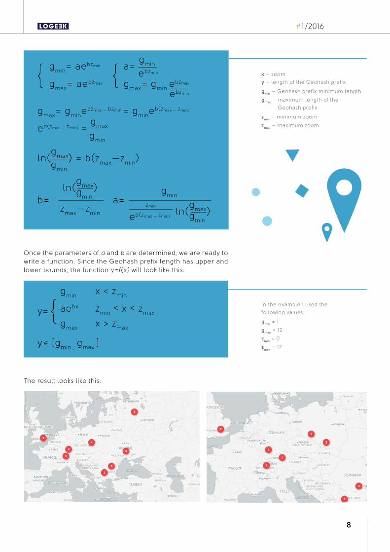
Once the parameters of a and b are determined, we are ready to write a function. Since the Geohash prefix length has upper and lower bounds, the function y=f(x) will look like this:
x – zoom
y – length of the Geohash prefix
gmin – Geohash prefix minimum length
gmax – maximum length of the
Geohash prefix
zmin – minimum zoom
zmax – maximum zoom
In the example I used the
following values:
gmin = 1
gmax = 12
zmin = 0
zmax = 17
The result looks like this:
#1/2016
8

Clustering is suitable for any project where objects displayed on a map are barely distinguishable due to their large number. Server-side clustering through Geohash improves user expe-rience and performance, significantly reducing the response payload for the client, reducing what can be thousands of objects to a few clusters.
EVGENIY KHYST
AN INTERACTIVE EXAMPLE IS AVAILABLE AT GEOHASH-EVGENIYKHIST.RHCLOUD.COM
THE SOURCE CODE FOR THE EXAMPLE IS AVAILABLE ON GITHUB: GITHUB.COM/EVGENIY-KHIST/GEOHASH-EXAMPLE
Evgeniy is a software engineer and architect specializing in Java solutions development and solving complex architecture challenges with over six years of experience. He grad-uated with a degree in computer science from the National Aviation University in Kyiv, Ukraine, and is currently employed at Luxoft as a Lead Software Developer.
LUXOFT UKRAINE
#1/2016
9

#1/2016