
Series Title Atlantic Basin Chapter Title Tropical ... · In the North Atlantic basin, ... storms...
25
Metadata of the chapter that will be visualized online Series Title Chapter Title Tropical Cyclones Rainfall in the Observations, Reanalysis and ARPEGESimulations in the North Atlantic Basin Chapter SubTitle Copyright Year 2010 Copyright Holder Springer Science+Business Media B.V. Family Name Daloz Particle Given Name Anne S. Corresponding Author Suffix Division Organization CNRM Address 42 av. G. Coriolis, 31057, Toulouse Cedex 1, France Email [email protected] Family Name Chauvin Particle Given Name F. Author Suffix Division Organization CNRM Address 42 av. G. Coriolis, 31057, Toulouse Cedex 1, France Email [email protected] Family Name Roux Particle Given Name F. Author Suffix Division Organization OMP Address 22 av. E. Belin, 31400, Toulouse, France Email [email protected] Abstract In this chapter, we performed a climatological study of the tropicalcyclone (TC) precipitation in the satellite observations and the reanalysisfrom the ECMWF and NCEP/NCAR centers over the North Atlantic(NATL) basin. Using the recently developed best track IBTrACS (Kruket al. 2009; Knapp et al. 2009) we derived the mean daily TCs rainfall within10 # ×10 # box around the center of the TCs, the fraction of TCs rainfall to total rainfall andthe TCs precipitation efficiency (TCPE). These variables were used to assessthe ability of the reanalysis to represent the impact of TCs in alteringthe total rainfall over the North Atlantic basin.
Transcript of Series Title Atlantic Basin Chapter Title Tropical ... · In the North Atlantic basin, ... storms...
Metadata of the chapter thatwill be visualized online
Series Title
Chapter Title Tropical Cyclones Rainfall in the Observations, Reanalysis and ARPEGESimulations in the NorthAtlantic Basin
Chapter SubTitle
Copyright Year 2010
Copyright Holder Springer Science+Business Media B.V.
Family Name DalozParticleGiven Name Anne S.
Corresponding Author
SuffixDivisionOrganization CNRMAddress 42 av. G. Coriolis, 31057, Toulouse Cedex 1, FranceEmail [email protected]
Family Name ChauvinParticleGiven Name F.
Author
SuffixDivisionOrganization CNRMAddress 42 av. G. Coriolis, 31057, Toulouse Cedex 1, FranceEmail [email protected]
Family Name RouxParticleGiven Name F.
Author
SuffixDivisionOrganization OMPAddress 22 av. E. Belin, 31400, Toulouse, FranceEmail [email protected]
Abstract In this chapter, we performed a climatological study of the tropicalcyclone (TC) precipitation in thesatellite observations and the reanalysisfrom the ECMWF and NCEP/NCAR centers over the NorthAtlantic(NATL) basin. Using the recently developed best track IBTrACS (Kruket al. 2009; Knapp et al.
2009) we derived the mean daily TCs rainfall within10# ×10#box around the center of the TCs, the fractionof TCs rainfall to total rainfall andthe TCs precipitation efficiency (TCPE). These variables were used toassessthe ability of the reanalysis to represent the impact of TCs in alteringthe total rainfall over the NorthAtlantic basin.

BookID 211142 ChapID 004 Proof# 1 - 18/06/10
Uncor
recte
dPro
of
Chapter 4 1
Tropical Cyclones Rainfall in the Observations, 2
Reanalysis and ARPEGE Simulations 3
in the North Atlantic Basin 4
Anne S. Daloz, F. Chauvin, and F. Roux 5
In this chapter, we performed a climatological study of the tropical cyclone (TC)AQ1 6precipitation in the satellite observations and the reanalysis from the ECMWF andAQ2 7NCEP/NCAR centers over the North Atlantic (NATL) basin. Using the recently 8
developed best track IBTrACS (Kruk et al. 2009; Knapp et al. 2009) we derived 9
the mean daily TCs rainfall within 10ı�10ı box around the center of the TCs, the 10
fraction of TCs rainfall to total rainfall and the TCs precipitation efficiency (TCPE). 11
These variables were used to assess the ability of the reanalysis to represent the 12
impact of TCs in altering the total rainfall over the North Atlantic basin. The main 13
results show that: 14
� The maximum of cyclonic precipitation is located in the Caribbean Sea and the 15
Gulf of Mexico, for the observation and the reanalysis. 16
� TCs contribute to a maximum of precipitation (between 15ı and 25ıN) over the 17
Southern Gulf of Mexico, the Caribbean Sea and the West Atlantic Ocean for the 18
observation and the reanalysis. 19
� The most efficient TCs are located in the Gulf of Mexico, the Caribbean Sea and 20
the West Atlantic Ocean for the observation and the reanalysis. 21
We used a high resolution (0.5ı) stretched atmospheric global climate model 22
(GCM) ARPEGE to simulate the present and future TCs rainfall.The tracking of 23
TCs was realized with the method of Chauvin et al. (2006). With the present inte- 24
gration, we assessed the ability of ARPEGE in simulating the TCs rainfall and the 25
fraction and the efficiency of TCs rainfall. Future simulation has also been produced 26
to study the possible evolution of those variables. The main results for the present 27
and future simulations over the North Atlantic basin indicate that:
AQ3
28
A.S. Daloz and F. ChauvinCNRM, 42 av. G. Coriolis, 31057 Toulouse Cedex 1, Francee-mail: [email protected]; [email protected]
F. RouxOMP, 22 av. E. Belin, 31400 Toulouse, Francee-mail: [email protected]
J.B. Elsner et al. (eds.), Hurricanes and Climate Change: Volume 2,DOI 10.1007/978-90-481-9510-7 4, c� Springer Science+Business Media B.V. 2010

BookID 211142 ChapID 004 Proof# 1 - 18/06/10
Uncor
recte
dPro
of
A.S. Daloz et al.
� ARPEGE detects the maxima obtained by the observations and the reanalysis for 29
the TCs rainfall and the fraction. However, it overestimates them. 30
� ARPEGE obtains sparser results than the observations and the reanalysis for the 31
efficiency of TCs, but detects the maxima over the West and East NATL Ocean. 32
� ARPEGE presents a sensitivity to the time period, consistent with the real varia- 33
tion of TCs activity. 34
� The difference between the future and present integration shows a decreasing 35
contribution of the TCs rainfall and an increasing efficiency of TCs. 36
1 Introduction 37
Tropical cyclones (TCs) have a great impact on the environment. Rodgers and Adler 38
(2001) showed in the NATL basin, that precipitation associated to TCs represents 39
a small but significant amount of the total annual rainfall. Flooding produced by 40
the TCs rainfall can be quite destructive; they are currently the leading cause of 41
hurricane-related fatalities in the United States (Fitzpatrick 2006). Coastal commu- 42
nities devastated by strong hurricanes usually take years to recover. Inland flooding 43
associated with TCs accounted for a majority (57%) of the 600 US deaths due to 44
hurricanes between 1970 and 1999 (Rappaport 2000). 45
In the North Atlantic basin, the official hurricane season begins June 1 and 46
ends November 30, although activity has been observed outside this time frame. 47
Due to the changes of genesis location during the hurricane season (Neumann 48
et al. 1999), the genesis patterns in the Atlantic and the Gulf of Mexico can be 49
divided in tree categories (Fitzpatrick 2006): early season (June 1–July 15), mid- 50
season (July 16–September 20), and late season (September 21–November 30). In 51
the early-season, storms mostly occur in the Western Caribbean Sea and the Gulf of 52
Mexico. Midseason storms originate in the main basin of the tropical Atlantic Ocean 53
even if genesis still occur in the Gulf of Mexico, but not in the majority of cases, 54
and is virtually nonexistent in the Caribbean Sea. The mid-summer genesis lull in 55
the Caribbean Sea is possibly due to local enhancement of trade winds mixing the 56
ocean in the area (Inoue et al. 2008) or because conditions favorable for dynamic 57
instability only occur in the early and late season (Molinari et al. 1997). Genesis in 58
the tropical Atlantic Ocean peaks in the midseason. Water temperatures are warm 59
enough to immediately impact tropical waves propagating off the African continent. 60
The late season witnesses a quick decline in the main basin of the tropical Atlantic 61
Ocean. However the Gulf of Mexico experiences a more gradual decline and the 62
Caribbean Sea a revival of storm formation. 63
According to the Fourth Intergovernmental Panel on Climate Change (IPCC 64
2007), it is difficult to distinguish any man-induced long-term trend of the cyclonic 65
activity and scenarios for a warmer climate do not converge on any trend in the in- 66
tensity or number of TCs. Most recent studies assessing the associated precipitation 67
to TCs in the NATL basin indicate that an increase may be induced by a warmer 68
climate (Lau et al. 2008). However, questions remain concerning the ability of the 69

BookID 211142 ChapID 004 Proof# 1 - 18/06/10
Uncor
recte
dPro
of
4 TCs rainfall observed and simulated in the NATL basin.
reanalysis and the global climate models (GCMs, General Circulation Models) to 70
simulate the amount that TCs contribute to the total rainfall, how the cyclonic pre- 71
cipitation is distributed geographically or the precipitation efficiency of the TCs. 72
Rodgers and Adler (1999) first estimated monthly TC rainfall using Special Sen- 73
sor Microwave Imager (SSM/I) satellite data in the Western North Pacific (WNP) 74
Ocean. They indicated that about 7% of the rainfall to the entire domain of the 75
WNP from June to November is due to TCs and also that TCs rainfall contribute 76
to a maximum of 40% off the lower Baja California. They also studied the impact 77
of El Nino on the TCs rainfall, and they noticed that in general, TCs rainfall is en- 78
hanced during El Nino years. Dedicated to the WNP basin, Ren et al. (2006) studied 79
the TCs rainfall using stations observations in China. They showed that in most of 80
the southeastern regions, TCs rainfall accounts for more than 20–40% of the total 81
annual precipitation. They suggested that China has experienced decreasing TCs 82
rainfall influence over the past 48 years, presenting downwards trends of the TCs 83
rainfall volume, the annual frequency of torrential events and the contribution of 84
TCs rainfall. Wu et al. (2007) confirmed the decreasing influence of the TCs rainfall 85
using station observations in the Hainan Islands. In the WNP basin, Kubota (2009) 86
investigate the effects of TCs on seasonal and interannual rainfall variability by us- 87
ing rainfall data in stations. They showed that, in some regions, TC rainfall exceed 88
60% of the total rainfall. They also found that the interannual variability of the TC 89
rainfall is primarily modulated by El Nino-Southern Oscillation (ENSO). Hasegawa 90
and Emori (2005) used a relatively high resolution (1.1ı) atmospheric GCM to simu- 91
late TCs rainfall within the WNP basin under present day and doubled CO2 climates. 92
They found an increase in mean TCs rainfall over Japan with doubling CO2 despite 93
an accompanying decrease in the frequency and intensity of TCs. In the NATL basin, 94
Rodgers and Adler (2001) showed that the contribution was around 4% for the en- 95
tire basin, but regionally could reach 30% in the northeast of Puerto Rico, 15ıW, 96
55ıW and off the west coast of Africa. During warm El Nino events TCs rainfall is 97
inhibited. Larson (2004) used gridded daily rainfall analysis based on rain gauge ob- 98
servations and found that landfalling TCs contribute up to 15–20% of rainfall along 99
the US Gulf and Mexican coast on average. Moreover they noted that tropical cy- 100
clone activity was modulated on both seasonal and intraseasonal time scales by the 101
Arctic Oscillation (AO) and El Nino. During La Nina conditions with AO positive 102
conditions, the atmospheric circulation is more conducive to activity in the main de- 103
velopment region. Sheperd et al. (2007) studied the contribution of tropical cyclones 104
to extreme rainfall in four mini-basins near coastal southeastern United States using 105
satellite precipitation dataset (TRMM). They noticed that major hurricanes produce 106
the most extreme rainfall days, but tropical depression/storm days contribute most 107
significantly to cumulative seasonal rainfall (8–17%) and are thus more critical to 108
assess trends. Lau et al. (2008) conducted a study with GPCP and TRMM rainfall 109
data on the relationship between TCs and extreme rain events in the NATL and WNP 110
basins. Results show that climatologically, TCs contribute to 8% of rain events and 111
17% of total rain amount in NATL, compared to 9% of rain events and 21% of rain 112
amount in WNP. In the NATL basin, there is a positive trend in the contribution 113
of TCs to extreme events. The last result is confirmed by Knight and Davis (2009) 114

BookID 211142 ChapID 004 Proof# 1 - 18/06/10
Uncor
recte
dPro
of
A.S. Daloz et al.
for the Southeastern United States where they studied the contribution of tropical 115
cyclones to extreme rainfall with surface observation station. They attributed this 116
increase to the storm wetness (precipitation per storm), the storm frequency and 117
storm duration driven by natural decadal oscillations or by large-scale warming of 118
the environment. Based on the TRMM database, Jiang and Zipser (2009) studied 119
the global, seasonal and interannual variations of the monthly TCs rainfall in the six 120
basins of tropical cyclogenesis. For the NATL basin they found that, TCs contribute 121
8–9%, with a maximum contribution in September and more generally during La 122
Nina years. 123
The next question that should be addressed is the manner in which reanalysis and 124
GCMs simulate the influence of the TCs to the total North Atlantic rainfall. In a first 125
part, we focus on the study of the TCs rainfall from the satellite observation and the 126
reanalysis. The mean daily North Atlantic TCs rainfall is determined using the re- 127
cently developed best track, IBTrACS. We also established two quantitative metrics 128
for the cyclonic rainfall associated with tropical systems; the mean precipitation dis- 129
tribution of the TCs and the precipitation efficiency of the TCs. The second section 130
is dedicated to the analysis of high resolution present and future (0.5ı) stretched 131
grid experiment using the tracking method presented in Chauvin et al. (2006). The 132
final section provides conclusion and discussions. 133
2 Observation and Reanalysis 134
2.1 Datasets and Tracking Methodology 135
2.1.1 Datasets 136
Satellite Observations 137
� TRMM 138
The Tropical Rainfall Measurement Mission (TRMM) (daily; 3B-42; 0.25ı by 139
0.25ı grid) is used to generate daily gridded precipitation data (Huffman et al. 2007). 140
TRMM rainfall estimates are produced in four stages: (1) the microwave estimates 141
precipitation are calibrated and combined, (2) infrared precipitation estimates are 142
created using the calibrated microwave precipitation, (3) the microwave and IR es- 143
timates are combined, and (4) rescaling to monthly data is applied. 144
� GPCP 145
The Global Precipitation Climatology Project (GPCP) (daily; 1DD; 1ı grid by 146
1ı grid) daily precipitation is produced at the NASA Goddard Space Flight Center. 147
They used the geo-synchronous-satellite operators to collect histograms of geo-IR 148
brightness temperature that allowed the estimation of the precipitation. To complete 149

BookID 211142 ChapID 004 Proof# 1 - 18/06/10
Uncor
recte
dPro
of
4 TCs rainfall observed and simulated in the NATL basin.
the global coverage, they estimated the precipitation outside of the geo-IR coverage 150
using sounding data from low-earth polar satellites. The different methods employed 151
for the construction of this dataset are detailed in Huffman et al. (2001). 152
Reanalysis 153
ECMWF (European Centre for Medium-range Weather Forecasts) – Reanalysis 154
� ERA-40 155
A 44-year integration (1958–2001) ERA-40 product (daily, 1.12ı by 1.12ı grid) 156
has been developed by the ECMWF. This dataset is obtained through a global spec- 157
tral model with T159L60 truncation. ERA data are freely distributed to the scientific 158
community, but after being downgraded to a lower resolution corresponding to a 159
T95 truncation ( 2.5ı resolution). Analysis involves comprehensive use of satellite 160
data, starting 1972 and later including Cloud Motion Winds will be used from 1979 161
onwards. More details can be found in Uppala et al. (2005). 162
� ERA-Interim 163
The ERA-Interim (daily, 1.5ı by 1.5ı grid) archive is more extensive than that for 164
ERA-40. The number of pressure levels is increased from ERA-40’s 23 to 37 levels, 165
main advances are done in the data assimilation and the sets of observations acquired 166
for ERA-40 are supplemented by data for later years from ECMWF’s operational 167
archive. Several of the problems experienced in ERA-40 have been significantly 168
reduced in ERA-Interim such as the too-strong tropical oceanic precipitation begin- 169
ning in the 1990s (Uppala et al. 2008).
AQ4
170
NCEP (National Center for Environmental Prediction / NCAR (National Center for 171
Atmospheric Research – Reanalysis 172
� NCEP-1 173
This data archive is issued by NCEP/NCAR center, covering the period from 174
1948 to present. NCEP-1 reanalysis (daily; 2.5ı by 2.5ı grid) was provided by a 175
global spectral model with T62 truncation and 28 vertical levels (T62L28; Kalnay 176
et al., 1996). 177
� NCEP-2 178
NCEP-2 (daily; 1.875ı by 1.875ı grid) is an improved version of the NCEP 179
Reanalysis I model that fixes errors and updates parameterizations of physical pro- 180
cesses. For a detailed explanation of the improvements see Kanamitsu et al. (2002). 181
2.1.2 Tracking Methodology 182
The NOAA National Climatic Data Center (NCDC) created a new global tropi- 183
cal cyclone 6-hourly best track dataset. The International Best Track Archive for 184

BookID 211142 ChapID 004 Proof# 1 - 18/06/10
Uncor
recte
dPro
of
A.S. Daloz et al.
Climate Stewardship, IBTrACS is a global best track compilation dataset which 185
contains information on all documented tropical cyclones which have been com- 186
piled and archived by many agencies from around the world. The methods used to 187
combine the disparate datasets into a centralized repository of global TC best track 188
data are detailed in Kruk et al. (2009) and Knapp et al. (2009). 189
2.2 TCs Rainfall 190
To assemble the mean daily TCs rainfall data, observations and reanalysis of TCs 191
rain rates are used. Only the rain rates that are observed within a 10ı�10ı box 192
around the center of TCs are sampled. This TC rain-rate sampling area is chosen 193
to encompass the majority of the rainfall that is contributed by TCs. The radius 194
of a TC, defined by the location and area of threshold speed, varies widely (radii 195
between 100 and 1,100 km have been observed) and is not necessarily proportional 196
to TC intensity. Most of the time, the precipitation shield is found to be asymmetric, 197
but for an objective procedure we supposed that the TCs rainfall were symmetric 198
around the center. The radius of 5ı around the center has already been tested by 199
Englehart and Douglas (2001) who showed that the distance between the center of 200
a TC and an outer edge of its cloud shield is between 550 and 600 km for 90% of 201
the cases. Larson (2004) also did some sensitivity tests between 2.5ı and 7.5ı radius 202
and found that radii smaller than 5ı necessarily exclude much of the TCs-rainfall. 203
Centers of the sampled tropical cyclones for the time of the observations and the 204
reanalyses comes from IBTrACS data. 205
The precipitation associated with TCs is seen in Fig. 1 for TRMM (left panel) and 206
GPCP (right panel) for 1998 to 2006, in the NATL ocean. Figure 1 shows that a TCs 207
rainfall maximum is located in the Caribbean Sea and in the South-eastern part of 208
the Gulf of Mexico, for both datasets. TRMM shows higher values (310 mm/year) 209
in comparison with GPCP (240 mm/year). We can see that in the Honduras Bay, 210
GPCP clearly underestimates the local maxima detected by TRMM. TRMM and 211
GPCP also detect three rainfall maxima in the center of the Atlantic Ocean. They 212
a b
Fig. 1 A plan view showing the TRMM (a) and the GPCP interpoled on the TRMM grid (b) NorthAtlantic TCs rainfall (mm/year) averaged over the time period 1998–2006

BookID 211142 ChapID 004 Proof# 1 - 18/06/10
Uncor
recte
dPro
of
4 TCs rainfall observed and simulated in the NATL basin.
a b
c d
Fig. 2 A plan view showing the ERA-40 (a), ERA-Interim (b), NCEP-1 (c) and NCEP-2 (d) NorthAtlantic tropical cyclones precipitation (mm/year) averaged over the time period 1989–2001
are located around the latitude 18ıN: on the French Antilles (64ıW), at the longi- 213
tudes 55ıW and 46ıW; attaining values between 160 and 220 mm/year. The highest 214
values of TCs rainfall are obtained by TRMM. Differences in range of value be- 215
tween TRMM and GPCP must partly be due to the higher spatial resolution of the 216
TRMM experiment. 217
Figure 2 presents the TCs rainfall calculated in the reanalysis from the ECMWF 218
and NCEP/NCAR centres in the NATL Ocean. On the top left panel, we find ERA- 219
40 and on the top right panel ERA-Interim for 1989–2001. A comparison of these 220
two figures shows that ERA-40 TCs rainfall is globally higher than ERA-Interim, 221
especially in the Carribean Sea and the center of the NATL basin. A reason for this 222
difference is explained in (Uppala et al. 2008). ERA-40 has a problem in term of 223
humidity from the 1990s. Strong discrepancies have been detected over the oceanic 224
domains, where values are more likely influenced by the physics of the atmospheric 225
model and the method used for the extrapolation of unmonitored locations. Few val- 226
ues of RH850 are lower than 0%, but numerous are higher than 100%. The maxima 227
encountered in Fig. 1 for the satellite observations, in the Caribbean Sea, the Gulf 228
of Mexico and the French Antilles are also detected by ERAs datasets, but with a 229
lower range of value, around 150 mm/year for ERA-40 (Fig. 2a) and 175 mm/year 230
for ERA-Interim (Fig. 2b). Theses differences in range of value must partly be due 231
to the change of time period between Figs. 1 and 2 from 1998–2006 to 1989–2001 232
respectively. However, it still remains an underestimate of TCs rainfall from the 233
reanalysis. The lower resolution could also impact local maxima in the center of 234
the NATL Ocean (18ıN, 55ıW) obtained by TRMM and GPCP (Fig. 1) because 235

BookID 211142 ChapID 004 Proof# 1 - 18/06/10
Uncor
recte
dPro
of
A.S. Daloz et al.
they are not detected by the ECMWF reanalysis. Except the eastern maxima (Fig. 1, 236
18ıN, 46ıW) not detected by TRMM, GPCP and ERAs datasets which comes from 237
the time period from 2002 to 2006. Figure 2 also shows the TCs rainfall calcu- 238
lated in two datasets of the NCAR/NCEP center in the NATL Ocean. Bottom left 239
panel shows NCEP-1 and the bottom right panel NCEP-2 for 1989–2001. The max- 240
imum encountered in Figs. 1 and 2a, b on the Caribbean Sea, the Gulf of Mexico 241
and the French Antilles are also detected by the NCEP datasets. NCEP-1 obtains a 242
lower range of value in comparison with TRMM and GPCP, around 175 mm/year 243
(Fig. 2c) and NCEP-2 (Fig. 2d) attains values in between the satellite observations 244
with 270 mm/year. Both NCEP datasets miss the local maxima situated at 18ıN, 245
55ıW. It should also be noticed that a maximum appears for NCEP-1 and especially 246
NCEP-2 in the Bay in front of Panama and Costa Rica that is not detected by ERAs 247
reanalysis, it could be an artifact of the NCEPs reanalysis. 248
Uppala et al. (2008) allows us to identify ERA interim as the more reliable 249
dataset in comparison with ERA-40. The results from the Figs. 1 and 2 pointed 250
out NCEP-2 with regard to NCEP-1 . NCEP-2 is even closer than ERA-Interim to 251
the results obtained by our reference TRMM in terms of amplitude and localization 252
of TCs precipitation maxima. The differences between ERA-Interim and NCEP-2 253
come partly from the way of assimilating the satellite observations. NCEP-2 directly 254
assimilates the rain rates from the instruments on the satellite TRMM, the TRMM 255
Microwave Imager (TMI) and the Special Sensor Microwave Imager (SSM/I). On 256
the other hand, ERA-interim only uses the data from the SSM/I instruments and they 257
do not assimilate the rain rate but the humidity profiles obtained with the variance. 258
Figure 3 presents the TCs rainfall of ERA-Interim (Fig. 3a) and NCEP-2 (Fig. 3b) 259
on the common time period from 1998 to 2006. Figure 3 confirms the good agree- 260
ment between TRMM and NCEP-2 in amplitude and localization of the maxima 261
of TCs rainfall. The amplitudes of the maxima from NCEP-2 in the North of the 262
Caribbean Sea and the French Antilles islands is nearly the same as those obtained 263
by TRMM (Fig. 1a). However, we should also notice that the maximum in the South 264
of the Caribbean Sea detected by NCEP-2 and discussed in the precedent section 265
seems to be an artifact of this dataset as we are now on the same time period, and 266
a b
Fig. 3 A plan view showing the ERA-Interim (a) and NCEP-2 (b) North Atlantic tropical cyclonesprecipitation (mm/year) averaged over the time period 1998–2006

BookID 211142 ChapID 004 Proof# 1 - 18/06/10
Uncor
recte
dPro
of
4 TCs rainfall observed and simulated in the NATL basin.
t1.1 Table 1 TCs rainfall averaged over the four regions defined in Fig. 4 for thesatellite observations TRMM and GPCP, and the reanalysis ERAI and NCEP2
t1.2 TCs rainfall (mm/year) NW-NATL NE-NATL SW-NATL SE-NATL
t1.3 TRMM 68.43 18.73 81:53 55.17t1.4 GPCP 40.51 11.76 49:02 39.85t1.5 ERAI 54.99 15.90 85:79 53.90t1.6 NCEP2 89.79 16.81 128:24 62.67
Fig. 4 A plan view showing the map of the NATL basin with four boxes presenting the areas ofstudies: NW-NATL, NE-NATL, SW-NATL and SE-NATL
this maximum is not appearing in TRMM. In order to obtain a more objective vi- 267
sion of the performance of GPCP, ERA-interim and NCEP-2 in comparison with 268
TRMM, we derived the mean TCs rainfall in different regions of the NATL basin 269
presented in Table 1. The NATL basin has been divided in four areas as presented 270
in Fig. 4. The coordinates of the regions are 271
� NW (North-Western) – NATL D 96–56ıW and 22–30ıN 272
� NE (North-Eastern) – NATL D 55–15ıW and 22–30ıN 273
� SW (South-Western) – NATL D 96–56ıW and 5–21ıN 274
� SE (South-Eastern) – NATL D 55–15ıW and 5–21ıN 275
Table 1 allows us to see that for the TCs rainfall in average, ERA-Interim seems 276
to be closer to TRMM than GPCP and NCEP-2 in the four areas of study. The bias 277
encountered for NCEP-2 in the Caribbean Sea is visible in the Table 1 as the value 278
of TCs rainfall in the SW-NATL zone is the highest for NCEP-2. With Figs. 1 and 3, 279
we noticed that in term of amplitude of maxima NCEP-2 offers the closest results 280
to TRMM, but the Table 1 showed that in term of average, ERA-Interim seems to 281
be closer. 282
As we have seen with the study of the Figs. 1 to 3, GPCP, ERA-Interim and 283
NCEP-2 underestimate, miss or create some of the TCs rainfall maxima when com- 284
paring with TRMM. We hypothesized that these biases could be related to the 285
higher spatial resolution of TRMM. The lower resolution of GPCP and the reanal- 286
ysis datasets could have an effect on the winds and on the representativeness of the 287

BookID 211142 ChapID 004 Proof# 1 - 18/06/10
Uncor
recte
dPro
of
A.S. Daloz et al.
a b
c d
Fig. 5 A plan view showing the TRMM (a), GPCP (b), ERAI (c) and NCEP-2 (d) North Atlantictropical cyclones precipitation (mm/year) averaged over the time period 1998–2006 for the systemsfrom Tropical Storm to Category 2 on the Saffir–Simpson scale
different categories of TCs. Figure 5 presents the TCs rainfall associated with sys- 288
tems from Tropical Storms (TSs) to Category 2 of TCs for the satellite observations 289
TRMM (Fig. 5a), GPCP (Fig. 5b), the reanalysis ERA-Interim (Fig. 5c) and NCEP- 290
2 (Fig. 5d) for the time period 1998–2006 on the NATL basin. TRMM (Fig. 5a) 291
shows the same maximum encountered in Fig. 1a, on the Caribbean Sea and lo- 292
cal maximum in the center of the NATL basin (55ıW and 46ıW) but they attain 293
lower values and are less spread. GPCP (Fig. 5b) presents the same maximum with 294
an underestimate in comparison with TRMM, which is coherent with the results of 295
Fig. 1b for the total TCs rainfall. ERA-Interim misses all the maximum obtained by 296
TRMM and overestimates the TCs rainfall in the Honduras Bay. NCEP-2 (Fig. 5d) 297
overestimates the maximum on the North of the Caribbean Sea and does not show 298
those in the center of the NATL basin. NCEP-2 presents a maximum in the South of 299
the Caribbean Sea assumed as an artifact, as it is present neither in TRMM, nor in 300
GPCP. NCEP-2 also represents fairly well the maximum in the Main Development 301
Region (MDR) except that it is located too West. 302
Figure 6 presents the precipitation from intense TCs (Category 3 to 5) for TRMM 303
(Fig. 6a), GPCP (Fig. 6b), ERA-Interim (Fig. 6c) and NCEP-2 (Fig. 6d) from 1998 304
to 2006 in the NATL basin. TRMM presents a maximum of precipitation for intense 305
TCs in the North of the Caribbean Sea with the maximum cumulated value equal to 306
what is obtained at the same place for weak TCs (TS to Category 2). GPCP, ERA- 307
Interim and NCEP-2 find the same maxima with nearly the same rain rate as TRMM 308
for NCEP-2, but GPCP and ERA-Interim present an underestimate. The maxima on 309

BookID 211142 ChapID 004 Proof# 1 - 18/06/10
Uncor
recte
dPro
of
4 TCs rainfall observed and simulated in the NATL basin.
a b
c d
Fig. 6 A plan view showing the TRMM (a), GPCP (b), ERAI (c) and NCEP-2 (d) North Atlantictropical cyclones precipitation (mm/year) averaged over the time period 1998–2006 for the systemsfrom Catergory 3 to 5 on the Saffir–Simpson scale
the center of the NATL basin are nearly the same for GPCP in comparison with 310
TRMM, however NCEP-2 and ERA-Interim missed it, except the one on the French 311
Antilles. 312
Figures 1 to 6 present the tropical cyclonic precipitation in satellite observation 313
and reanalysis. They suggest that the tropical cyclone rainfall maxima are concen- 314
trated in the subtropical latitudes from the middle NATL basin, toward the Gulf of 315
Mexico. No TC rainfall is found off the west coast of Spain and Africa and equar- 316
torward of 5ıN latitude. The regional area with the greatest tropical cyclone rainfall 317
occurs in the Caribbean Sea and the Gulf of Mexico. Many weak and intense TCs 318
are born and intensify in this region. Local maximum are also found in the center of 319
the NATL Ocean. For example around the French Antilles, which is a region where 320
many TCs recurve and momentarily intensify. We also noticed that the values of 321
the maxima of TCs rainfall are higher for the satellite observations in comparison 322
with the reanalysis; this is especially true for TRMM. The dissimilarities between 323
the datasets are partly due to a difference of spatial resolution which create discrep- 324
ancies in the representation of weak and intense TCs. 325
2.3 Fraction of TCs Rainfall 326
The fraction of TCs rainfall is defined as the ratio of tropical cyclone rainfall to total 327
rainfall multiplied by one hundred. Figure 7 presents the geographical distribution of 328
the percentage of rainfall contribution by TCs over the NATL basin for 1998–2006 329
for the satellite observations TRMM (Fig. 7a) and GPCP (Fig. 7b), ERA-Interim 330

BookID 211142 ChapID 004 Proof# 1 - 18/06/10
Uncor
recte
dPro
of
A.S. Daloz et al.
a b
c d
Fig. 7 Fraction of TCs rainfall (%) in the NATL basin for 1998–2006 for: TRMM (a), the GPCPinterpoled on the TRMM grid (b), ERA-Interim (c) and NCEP2 (d)
(Fig. 7c) and the reanalysis NCEP-2 (Fig. 7d). In the eastern NATL Ocean (12– 331
20ıN; 56–30ıW), there is a broad region where the contribution of TCs rainfall 332
is high for TRMM (Fig. 7a), GPCP (Fig. 7b), ERA-Interim (Fig. 7c) and NCEP-2 333
(Fig. 7d). The satellite observations obtain values between 30% and 40%, the re- 334
analysis between 20% and 25%. This result shows that the area where contribution 335
of TCs rainfall is the highest (eastern NATL) is not necessarily the region of highest 336
TCs rainfall rates (cf. Fig. 1, western NATL). In the western NATL Ocean, the con- 337
tribution of TCs rainfall is not negligible as it reaches around 30% for TRMM, 20% 338
for GPCP and NCEP-2, and 10% for ERA-Interim. The fraction is lower as others 339
mecanims such Mesoscale Convective Systems (MCSs, Houze, 1988) contribute to 340
the total rainfall. It should also be noticed that a large area (green in the figures) for 341
the four datasets presents no negligible values of fraction, as it attains values around 342
10% of the total rainfall. 343
Table 2 presents the averaged fraction of TCs rainfall for the observations and 344
the reanalysis on the four areas of study defined in Section 2.2. In average for 345
the four regions, all the datasets underestimate the fraction of TCs rainfall from 346
TRMM. The closer results on the four regions are obtained by NCEP-2 in com- 347
parison with TRMM even if it is underestimated; GPCP and ERA-Interim are both 348
under NCEP-2. These results put in evidence the good results of NCEP-2 in terms 349
of maximum and average for the fraction of TCs rainfall, that is maybe due to the 350
way of assimilating the precipitation. Table 2 also shows that GPCP and the two 351
reanalysis datasets obtain a too low contribution of TCs rainfall to total rainfall. 352

BookID 211142 ChapID 004 Proof# 1 - 18/06/10
Uncor
recte
dPro
of
4 TCs rainfall observed and simulated in the NATL basin.
t2.1 Table 2 Fraction of TCs rainfall (%) averaged over the four regions definedin Fig. 4 for the satellite observations TRMM and GPCP, and the reanalysisERAI and NCEP-2
t2.2 Fraction (%) NW-NATL NE-NATL SW-NATL SE-NATL
t2.3 TRMM 7.5 3.48 8.47 10:11
t2.4 GPCP 4.83 2.17 5.64 7:38
t2.5 ERAI 5.07 2.04 5.81 6:60
t2.6 NCEP2 6.71 2.13 6.88 7:75
2.4 Tropical Cyclonic Precipitation Efficiency – TCPE 353
We defined the TCs precipitation efficiency (TCPE) as the mean precipitation per 354
day of TCs. TCPE is equal to the precipitation associated with TCs, divided by 355
the number of days of TCs activity over each grid point in a 10ı � 10ı box of 356
precipitation. The unit of this variable is mm/ TC day. Figure 8 presents the TCPE 357
over the NATL basin averaged over the time period 1998–2006 for TRMM (Fig. 8a), 358
GPCP (Fig. 8b), ERA-Interim (Fig. 8c) and NCEP-2 (Fig. 8d). A maximum over the 359
Southern Gulf of Mexico and the Caribbean Sea is detected by TRMM (30 mm/TC 360
day), GPCP (35 mm/TC day) and NCEP-2 (30 mm/TC day). TRMM also detects a 361
maximum of TCPE in front of the West African coast (20 mm/TC day). In this area 362
GPCP (30 mm/TC day) and NCEP-2 (36 mm/TC day) also find a maximum but they 363
overestimate it, as it is higher and further spread. Globally, GPCP is overestimating 364
the TCPE. NCEP-2 has a maximum in the South of the Caribbean Sea, but as we 365
have seen with the TCs rainfall Figs. 1a and 3b, it is an artifact of the reanalysis. In 366
the Western NATL basin, all the datasets obtain a maximum off the West African 367
coast, but NCEP-2 (Fig. 8d) overestimates it. 368
Table 3 presents the TCPE for the four regions of the NATL basin described 369
in Section 2.2 for the satellite observations and the reanalysis for the time period 370
1998–2006. ERA-Interim is closer to TRMM but still underestimates the Northern 371
region and overestimates the Southern region. These results show a better agreement 372
between ERA-Interim and TRMM than from GPCP and NCEP-2 with TRMM for 373
the average of TCPE. 374
The results obtained in Figs. 1 to 8 show that in the Gulf of Mexico and the 375
Caribbean Sea, we have a maximum of tropical cyclonic precipitation (Fig. 1 to 6) 376
certainly due to the high efficiency of the TCs in this region (Fig. 8). However the 377
contribution of TCs rainfall to total rainfall is not the highest in the western NATL 378
basin (Fig. 7) even if it is not negligible as it varies between 10% and 25%. Never- 379
theless in this area other mechanisms are highly contributing to the total rainfall. It 380
should be noticed that, the regions where the fraction is over 10% and the TCPE is 381
over 10 mm/TC day are inhabited area such as the South of Florida, Cuba and the 382
French Antilles. In the eastern part of the NATL basin, we do not find such high 383
values of TCs rainfall (Fig. 1 to 6) and TCPE (Fig. 8) but the fraction is really ele- 384
vated (Fig. 7) due to the type of precipitation in this area. The rainfall in this region 385

BookID 211142 ChapID 004 Proof# 1 - 18/06/10
Uncor
recte
dPro
of
A.S. Daloz et al.
a b
c d
Fig. 8 Tropical cyclonic precipitation efficiency (TCPE, mm/TC day) in the NATL basin for1998–2006 for: TRMM (a), the GPCP interpoled on the TRMM grid (b), ERA-Interim (c) andNCEP-2 (d)
t3.1 Table 3 TCPE averaged over the four regions defined in Fig. 4 for the satelliteobservations TRMM and GPCP, and the reanalysis ERAI and NCEP2
t3.2 TCPE (mm/TC day) NW-NATL NE-NATL SW-NATL SE-NATL
t3.3 TRMM 6.16 12:16 5:2 8:4
t3.4 GPCP 2.32 5:76 1:88 2:08
t3.5 ERAI 7.48 10 8:4 12:28
t3.6 NCEP2 5.6 9:52 6:04 7:52
comes in majority from the tracks of the just born TCs from the West African con- 386
tinent. The fraction and the TCPE have allowed us to indicate the areas where TCs 387
are the most dangerous in term of precipitation and through the possible spot of 388
floods. These two variables have also permitted us to test the different datasets of 389
satellite observations and reanalysis. This characteristic can also be used to test the 390
capability of the models to represent the tropical cyclonic precipitation. 391
3 Global Climate Model ARPEGE 392
3.1 Model Description and Tracking Methodology 393
3.1.1 Model Description and Experiment Design 394
The ARPEGE-Climate model originates from the ARPEGE/IFS (Integrated 395
Forecast System) numerical weather prediction model developed jointly by

BookID 211142 ChapID 004 Proof# 1 - 18/06/10
Uncor
recte
dPro
of
4 TCs rainfall observed and simulated in the NATL basin.
Meteo-France and ECMWF. It is a spectral atmospheric model with a hybrid - 396
pressure vertical coordinate. Since the first release of the ARPEGE-Climate model 397
(Deque et al. 1994), many developments have been included, both dynamical and 398
physical. Here we use the third generation ARPEGE-Climat model (Deque 1999). 399
The main difference compared to former versions is the use of a time-level semi- 400
lagrangian numerical integration scheme with a 30 min time-step. The physical 401
package includes the turbulence-scheme of Louis et al. (1981), the statistical cloud 402
scheme of Ricard and Royer (1993) and the mass-flux convective scheme with Kuo- 403
type closure of Bougeault (1985). The radiative scheme is derived from Morcrette 404
(1990) and is activated every 3 hours. More details about the physics of the model 405
can be found in Geleyn et al. (1995). 406
A rotated-stretched twentieth–twenty-first century experiment was performed us- 407
ing the ARP-EGE-Climat GCM (Courtier and Geleyn 1988), to represent Atlantic 408
hurricane activity. The grid stretching technique permits distortion of the initial 409
globally uniform grid in such a way that a maximum concentration of grid points 410
will cover the region of interest at the expense of antipode. Once the region of in- 411
terest is chosen, the grid is rotated so as to bring the pole over the center of the 412
domain. This method has been used and validated for a long time in operational me- 413
teorological forecast (Courtier et al. 1991) and in climate modeling studies (Deque 414
and Piedelievre 1995; Lorant and Royer 2001; Moustaoui et al. 2002). It has also 415
been validated by Chauvin et al. (2006) for the ARPEGE integrations used in this pa- 416
per. In addition, they showed that, for a spatial resolution high enough, ARPEGE is 417
able to represent TCs structures. The stretching coefficient is 2.5 in our simulations, 418
and the pole of the grid is located 60ıW, 20ıN in the Western Atlantic. Simula- 419
tions for present and future climates are 30 years long with year-to-year variation 420
of SSTs, reproducing the interannual variability of 1960–1989 observed patterns. 421
The equivalent resolution is of approximately 50 km over the Atlantic basin and 422
decreases linearly when going far away from the pole to reach approximately 310 423
km at the opposite. Another experiment was performed in the stretched configura- 424
tion for the twenty-first century scenario. For the future climate, an anomaly was 425
added to the 1960–1989 climatology. SST anomaly was taken from a Hadley Centre 426
coupled simulation and following a SRES-A2 IPCC scenario for the GHGs (Johns 427
et al. 2001) for 2070–2099. 428
3.1.2 Tracking Methodology 429
In order to track the tropical storms, Chauvin et al. (2006) used and updated the 430
method developed at Mto-France by Ayrault and Joly (2000) to track mid-latitude 431
lows for the Atlantic tropical cyclones. For the construction of the tracks, criteria 432
from Bengtsson et al. (1995) have been introduced and the following criteria were 433
retained: 434
� Mean sea level pressure (MSLP) is a local minimum (considered therefore as the 435
center of the system) 436
� 850 hPa vorticity � VT (a vorticity threshold) 437

BookID 211142 ChapID 004 Proof# 1 - 18/06/10
Uncor
recte
dPro
of
A.S. Daloz et al.
� 850 hPa wind intensity � WT (a wind threshold) 438
� Mean 700–300 hPa temperature anomaly � TT (a temperature threshold) 439
� 300 hPa temperature anomaly � 850 hPa temperature anomaly 440
� 850 hPa tangential wind � 300 hPa tangential wind 441
Anomalies are defined as the difference between the system and its environment. For 442
each criterion, a threshold is fixed and a grid point, at a given time step, must meet all 443
conditions to be selected for a track. Choice of the thresholds was made subjectively, 444
partly in agreement with literature and partly to compare favourably with the real 445
world. The threshold combinations adopted, for this case, are the followings 446
VT D 14.10–5 1/s, WT D 15 m/s and TT D 3ıK 447
The entire description of the tracking method is given in Chauvin et al. (2006). 448
3.2 Present Integration 449
3.2.1 TCs Rainfall 450
Figure 9 presents the tropical cyclonic precipitation in the NATL basin in the present 451
integration of ARPEGE for the three decades: 1960–1969 (Fig. 9a), 1970–1979 452
(Fig. 9b) and 1980–1989 (Fig. 9c). The first decade (Fig. 9a) presents a maximum of 453
TCs rainfall in the Caribbean Sea (850 mm/year) and from the South of the Gulf of 454
Mexico (500 mm/year) to the eastern Florida peninsula. We also have some traces of 455
a b
c
Fig. 9 TCs rainfall (mm/year) in the NATL basin in the present ARPEGE integration for the timeperiods:1960–1969 (a), 1970–1979 (b) and 1980–1989 (c)
BookID 211142 ChapID 004 Proof# 1 - 18/06/10
Uncor
recte
dPro
of
4 TCs rainfall observed and simulated in the NATL basin.
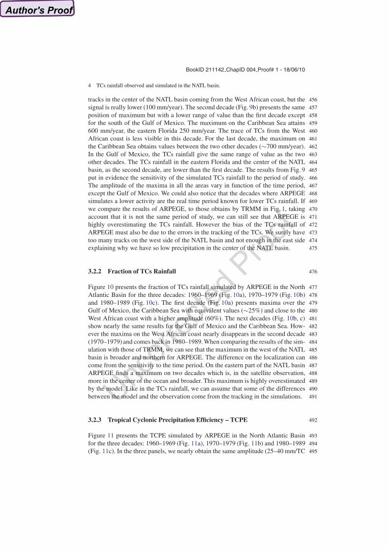
tracks in the center of the NATL basin coming from the West African coast, but the 456
signal is really lower (100 mm/year). The second decade (Fig. 9b) presents the same 457
position of maximum but with a lower range of value than the first decade except 458
for the south of the Gulf of Mexico. The maximum on the Caribbean Sea attains 459
600 mm/year, the eastern Florida 250 mm/year. The trace of TCs from the West 460
African coast is less visible in this decade. For the last decade, the maximum on 461
the Caribbean Sea obtains values between the two other decades (�700 mm/year). 462
In the Gulf of Mexico, the TCs rainfall give the same range of value as the two 463
other decades. The TCs rainfall in the eastern Florida and the center of the NATL 464
basin, as the second decade, are lower than the first decade. The results from Fig. 9 465
put in evidence the sensitivity of the simulated TCs rainfall to the period of study. 466
The amplitude of the maxima in all the areas vary in function of the time period, 467
except the Gulf of Mexico. We could also notice that the decades where ARPEGE 468
simulates a lower activity are the real time period known for lower TCs rainfall. If 469
we compare the results of ARPEGE, to those obtains by TRMM in Fig. 1, taking 470
account that it is not the same period of study, we can still see that ARPEGE is 471
highly overestimating the TCs rainfall. However the bias of the TCs rainfall of 472
ARPEGE must also be due to the errors in the tracking of the TCs. We surely have 473
too many tracks on the west side of the NATL basin and not enough in the east side 474
explaining why we have so low precipitation in the center of the NATL basin. 475
3.2.2 Fraction of TCs Rainfall 476
Figure 10 presents the fraction of TCs rainfall simulated by ARPEGE in the North 477
Atlantic Basin for the three decades: 1960–1969 (Fig. 10a), 1970–1979 (Fig. 10b) 478
and 1980–1989 (Fig. 10c). The first decade (Fig. 10a) presents maxima over the 479
Gulf of Mexico, the Caribbean Sea with equivalent values (�25%) and close to the 480
West African coast with a higher amplitude (60%). The next decades (Fig. 10b, c) 481
show nearly the same results for the Gulf of Mexico and the Caribbean Sea. How- 482
ever the maxima on the West African coast nearly disappears in the second decade 483
(1970–1979) and comes back in 1980–1989. When comparing the results of the sim- 484
ulation with those of TRMM, we can see that the maximum in the west of the NATL 485
basin is broader and northern for ARPEGE. The difference on the localization can 486
come from the sensitivity to the time period. On the eastern part of the NATL basin 487
ARPEGE finds a maximum on two decades which is, in the satellite observation, 488
more in the center of the ocean and broader. This maximum is highly overestimated 489
by the model. Like in the TCs rainfall, we can assume that some of the differences 490
between the model and the observation come from the tracking in the simulations. 491
3.2.3 Tropical Cyclonic Precipitation Efficiency – TCPE 492
Figure 11 presents the TCPE simulated by ARPEGE in the North Atlantic Basin 493
for the three decades: 1960–1969 (Fig. 11a), 1970–1979 (Fig. 11b) and 1980–1989 494
(Fig. 11c). In the three panels, we nearly obtain the same amplitude (25–40 mm/TC 495

BookID 211142 ChapID 004 Proof# 1 - 18/06/10
Uncor
recte
dPro
of
A.S. Daloz et al.
a b
c
Fig. 10 Fraction (%) in the NATL basin in a present ARPEGE integration for the timeperiods:1960–1969 (a), 1970–1979 (b) and 1980–1989 (c)
a b
c
Fig. 11 TCPE (mm/TC day) in the NATL basin in a present ARPEGE integration for the timeperiods:1960–1969 (a), 1970–1979 (b) and 1980–1989 (c)

BookID 211142 ChapID 004 Proof# 1 - 18/06/10
Uncor
recte
dPro
of
4 TCs rainfall observed and simulated in the NATL basin.
day) in the Gulf of Mexico and the Caribbean Sea. We can also notice the trace of 496
efficient TCs in the New Orleans and Guatemala coast, regions vulnerable to TCs. 497
For the TCPE, the sensitivity to the time period is visible especially off the West 498
African coast. The amplitude is nearly the same in the center and the east of the 499
NATL basin and is really close to what obtained TRMM in Fig. 1. 500
3.3 Future Integration 501
3.3.1 Fraction of TCs Rainfall 502
Figure 12 presents the fraction of TCs rainfall from the future integration 503
(2060–2089) minus the present integration (1960–1989) over the NATL basin. 504
The blue values indicate a decrease of fraction of TCs rainfall and the red, an in- 505
crease. This figure shows that for this configuration of ARPEGE, the contribution 506
of TCs rainfall is decreasing in the future in comparison with the present. But as the 507
fraction is a ratio this decrease means a decrease of TCs rainfall or an increase in 508
total rainfall. 509
3.3.2 Tropical Cyclonic Precipitation Efficiency – TCPE 510
Figure 13 presents the TCPE from the future integration (2060–2089) minus the 511
present integration (1960–1989) over the NATL basin. The blue values indicate a 512
decrease of TCPE and the red, an increase. It seems that the efficiency is slightly 513
increasing in the future, in comparison with the present, as the red value indicate a 514
positive difference between the two integrations. 515
c
Fig. 12 Difference in fraction of TCs rainfall (%) between the future (2060–2089) and present(1960–1989) ARPEGE integration in the NATL basin

BookID 211142 ChapID 004 Proof# 1 - 18/06/10
Uncor
recte
dPro
of
A.S. Daloz et al.
Fig. 13 Difference in TCPE (mm/TC day) between the future (2060–2089) and present(1960–1989) ARPEGE integration in the NATL basin
4 Conclusion and Discussions 516
The impacts of the TCs rainfall on geographical variability of the total rainfall over 517
the NATL basin is investigated in a first part, in daily satellite observations and 518
reanalysis. We studied TRMM and GPCP for the satellite observations, ERA-40, 519
ERA-Interim, NCEP-1 and NCEP-2 for the reanalysis. The patterns of TRMM TCs 520
rainfall are similar to GPCP features, but GPCP presents an underestimates in am- 521
plitude and misses some local maxima in the center of the NATL basin surely due 522
to the lower spatial resolution of the latter. Then, we studied the ability of GPCP 523
and the reanalysis to represent the tropical cyclonic precipitation in comparison with 524
TRMM. It may be surprising to study the TCs rainfall from the reanalysis as we said 525
before that the spatial resolution seems to be important for the TCs rainfall. However 526
the time period covered by the reanalysis is not offered by the satellite observations 527
and for the study of climate integrations, we need a longer time period, that is why 528
we tried to validate the reanalysis. In this aim, we used a variety of metrics such as 529
the fraction of TCs rainfall and the TCPE. We noticed the improvement with the new 530
versions of the reanalysis from ECMWF and NCEP/NCAR centers (ERA-Interim 531
and NCEP-2). We especially note the good representation of the TCs rainfall for 532
NCEP-2 in comparison with TRMM, that is surely due to the way that NCEP-2 as- 533
similates the precipitation. The maximum of cyclonic precipitation is located in the 534
Caribbean Sea and the Gulf of Mexico, for the observation and the reanalysis. GPCP 535
and ERA-Interim underestimate the TCs rainfall in comparison with TRMM due to 536
an underestimate of intense TCs. TCs contribute to a maximum of precipitation (be- 537
tween 15ı and 25ıN) over the Southern Gulf of Mexico, the Caribbean sea and the 538
West Atlantic ocean for the observation and the reanalysis.The most efficient TCs 539
are located in the Gulf of Mexico, the Caribbean Sea and the West Atlantic Ocean 540
for the observations and the reanalysis. 541

BookID 211142 ChapID 004 Proof# 1 - 18/06/10
Uncor
recte
dPro
of
4 TCs rainfall observed and simulated in the NATL basin.
In a second part, we studied the ability of ARPEGE to simulate the TCs rainfall in 542
present simulation. ARPEGE is able to detect the maxima of TCs rainfall, fraction of 543
TCs rainfall and TCs efficiency obtained in the observation and reanalysis however 544
it overestimates them in term of amplitude. The decomposition of the 30 years of 545
integrations in decades has permitted to show the sensitivity of the model to the time 546
period. It is interesting to notice that the two last decades present lower TCs rainfall 547
which is consistent with the real TCs activity. This study has also allowed to see 548
the problems in the localization of the tracks. The tracking produces too much TCs 549
in the western NATL basin and not enough off the West African coast. Finally, we 550
run a future simulation to see the possible evolution of the fraction of TCs rainfall 551
and the TCPE. The difference between the future and present simulations shows an 552
decreasing contribution of TCs rainfall to total rainfall and an increasing efficiency 553
of TCs. 554
References 555
Ayrault F, Joly A (2000) Une nouvelle topologie des depressions meterologiques: classification 556des phases de maturation. compte-rendus l’acadmie des sciences, sciences de la terre et des 557planetes. Earth Planet Sci 330:167–172 558
Bengtsson L, Botzet M, Esch M (1995) Simulation of hurricane-type vortices in a general circula- 559tion model. Tellus 47A:175–196 560
Bougeault P (1985) A simple parameterization of the large-scale effects of cumulus convection. 561Mon Weather Rev 113:2108–2121 562
Chauvin F, Royer JF, Deque M (2006) Response of hurricane-type vortices to global warming as 563simulated by the arpege-climat at high resolution. Clim Dynam 27:377–399 564
Courtier F, Freydier C, Geleyn JF, Rochas M (1991) The arpege project at meteo-france. ECMWFAQ5 565seminar proceedings, reading, 9–13 Sept 1991, Volume II pp 193–221 566
Courtier P, Geleyn J (1988) A global numerical weather prediction model with variable resolution: 567application to a shallow water equation. Quart J R Meteor Soc 114:1321–1346 568
Deque M (1999) Documentation arpege-climat. Tech Report Centre National de Recherches Me- 569teorologiques, Meteo-France, Toulouse, France 570
Deque M, Piedelievre J (1995) High resolution climate simulation over europe. Clim Dynam 57111:321–339 572
Deque M, Dreveton C, Braun A, Cariolle D (1994) 1994. Clim Dynam 10:249–266 573Englehart P, Douglas A (2001) The role of eastern north pacific tropical storms in the rainfall 574
climatology of western mexico. Int J Clim 21:1357–1370 575Fitzpatrick PJ (2006) Hurricanes, 2nd edition. ABC-CLIO 576Geleyn JF, Bazile E, Bougeault P, Deque M, Ivanovici V, Joly A, Labbe L, Piedelievre J, Piriou J, 577
Royer J (1995) Atmospheric parameterization schemes in meteo-france’s arpege nwp model. 578Proceedings of the ECMWF seminar pareterization of sub-grid scale physical processes, 5–9 579Sept 1994. ECMWF Reading, pp 385–402 580
Hasegawa A, Emori S (2005) Tropical cyclones and associated precipitation over the western north 581pacific: T106 atmospheric gcm simulation for present-day and doubled co2 climates. SOLA 5821:145–148 583
Houze RAJ (1988) Convective and stratiform precipitation in the tropics. In: Theon JS, Fugono NAQ6 584(eds) Tropical rainfall measurements, pp 27–35 585
BookID 211142 ChapID 004 Proof# 1 - 18/06/10
Uncor
recte
dPro
of
A.S. Daloz et al.
Huffman G, Adler R, Morrissey M, Bolvin D, Curtis S, Joyce R, McGavock B, Susskind J 586(2001) Global precipitation at one-degree daily resolution from multi-satellite observations. 587J Hydrometeor 2:36–50 588
Huffman G, Adler R, Bolvin D, Gu G, Nelkin E, Bowman K, Hong Y, Stocker E, Wolff D (2007) 589The trmm multisatellite precipitation analysis (tmpa): quasi-global, multiyear, combined- 590sensor precipitation estimates at fine scales. J Hydrometeor 8:38–55 591
Inoue M, Handoh IC, Bigg GR (2008) Bimodal distribution of tropical cyclogenesis in teh car- 592ribean: characteristics and environment factors. J Climate 15:2897–2905 593
IPCC (2007) Climate change 2007: the physical science basis. In: Solomon S, Qin D, Manning M,AQ7 594Chen Z, Marquis M, Averyt KB, Tignor M, Miller, HL (eds) Contribution of working Group I 595to the fourth assessment report of the intergovernmental panel on climate change. Cambridge 596University Press, Cambridge, United Kingdom and New York, NY, USA, pp 996 597
Jiang H, Zipser EJ (2009) Contribution of tropical cyclones to the global precipitation 598from 8 seasons of trmm data: regional, seasonal and interannual variations. J Climate. 599doi:10.1175/2009JCLI3303.1 600
Johns T, Gregory J, Ingram W, Johnson C, Jones A, Mitchell J, Roberts D, Sexton D, Stevenson 601D, Tett S, Woodage M (2001) Anthropogenic climate change for 1860 to 2100 simulated with 602the hadcm3 model under updated emission scenarios. Technical Note 22, Hadley Center p 22 603
Kalnay E, Kanamitsu M, Kistler R, Collins W, et al. (1996) Ncep/ncar 40 years reanalysis project. 604Bull Am Meteorol Soc 77:437–471 605
Kanamitsu M, Ebisuzaki W, Woolen J, Yang JK, Hnilo J, Fiorino M, Potter GL (2002) Ncep-doe 606amip-ii reanalysis (r-2). Bull Am Meteorol Soc 83:1631–1643 607
Knapp KR, Kruk M, Levinson DH, Gibney E (2009) Archive compiles new resource for global 608tropical cyclone research eos. AGU 90. doi:10.1029/2009EO060,002 609
Knight D, Davis R (2009) Contribution of tropical cyclones to extreme rainfall in the southeastern 610united states. J Geophys Res 14:D23,102. doi:10.1029/2009JD012,511 611
Kruk MC, Knapp K, Levinson D, Diamond H, Kossin J (2009) An overview of the international 612best track archive for climate stewardship (ibtracs). Twenty-first conference on climate vari- 613ability and change, Phoenix, AZ, AMS 614
Kubota H (2009) How much do tropical cyclones affect seasonal and interannual rainfall variability 615over the western north pacific. J Climate 22:5495–5510 616
Larson J (2004) Characteristics of landfalling tropical cyclones in the united states and mexico: 617climatology and interannual variability. J Climate 18:1247–1262 618
Lau KM, Zhou Y, Wu HT (2008) Have tropical cyclones been feeding more extreme rainfall? 619J Geophys Res 113. doi:10.1029/2008JD009,963 620
Lorant V, Royer J (2001) Seensitivity of equatorial convection to horizontal resolution in aqua- 621planet simulations with a variable-resolution gcm. Mon Weather Rev 129:2730–2745 622
Louis J, Tiedtke M, Geleyn J (1981) A short history of the operational pbl-parameterization 623at ecmwf. In: ECMWF workshop planetary boundary layer parameterization, Nov 1981, 624ECMWF, Reading, UK, pp 25–27 625
Molinari J, Knight D, Dickinson D, Vollaro D, Skubis S (1997) Potential vorticity, easterly waves 626and tropical cyclogenesis. Mont Weather Rev 127:520–534 627
Morcrette J (1990) Impact of changes to the radiation transfer parameterizations plus cloud optical 628properties in the ecmwf model. Mon Weather Rev 118:847–873 629
Moustaoui M, Royer JF, Chauvin F (2002) African easterly wave activity in a variable resolution 630gcm. Clim Dynam 25:289–301 631
Neumann CJ, Jarvinen BR, McAdie CJ, Hammer GR (1999) Tropical cyclones of the north atlanticAQ8 632ocean. National Climatic Data Center, p 206 633
Rappaport E (2000) Loss of life in the united states associated with recent atlantic tropical cyclones. 634Bull Am Meteorol Soc 81:2065–2073 635
Ren F, Wu G, Dong W, Wang X, Wang Y, Ai W, Li W (2006) Changes in tropical cyclone precipi- 636tation over china. Geophys Res Lett 33. doi: 10.1029/2006GL027,951 637
Ricard J, Royer J (1993) A statistical cloud scheme for use in an agcm. Ann Geophys 11: 6381095–1115 639

BookID 211142 ChapID 004 Proof# 1 - 18/06/10
Uncor
recte
dPro
of
4 TCs rainfall observed and simulated in the NATL basin.
Rodgers EB, Adler F (1999) Contribution of tropical cyclones to the north pacific climatological 640rainfall as observed from satellites. J Appl Meteorol 39:1658–1678 641
Rodgers EB, Adler F (2001) Contribution of tropical cyclones to the north atlantic climatological 642rainfall as observed from satellites. J Appl Meteorol 40(10):1785–1800 643
Sheperd JM, Grundstein A, Mote TL (2007) Quantifying the contribution of tropical cyclones 644to extreme rainfall along coastal southeastern united states. Geophys Res Lett 34. doi: 64510.1029/2007GL031,694 646
Uppala S, Dee D, Kobayashi S, Simmons A (2008) Evolution of reanalysis at ecmwf. In: Proceed-AQ9 647ings WCRP 648
Uppala SM, Kallberg PW, Simmons U A Jand Andrae, Bechtold VD, Fiorino M, Gibson JK, 649Haseler J, Hernandez A, Kelly GA, Li X, Onogi K, Saarinen S, Sokka N, Allan RP, Andersson 650E, Arpe K, Balmaseda MA, Beljaars ACM, Van De Berg L, Bidlot J, Bormann N, Caires S, 651Chevallier F, Dethof A, Dragosavac M, Fisher M, Fuentes M, Hagemann S, Holm E, Hoskins 652BJ, Isaksen L, Janssen PAEM, Jenne R, McNally AP, Mahfouf JF, Morcrette JJ, Rayner NA, 653Saunders RW, Simon P, Sterl A, Trenberth KE, Untch A, Vasiljevic D, Viterbo P, Woollen J 654(2005) The era-40 re-analysis. Q J Roy Meteorol Soc 131:2961–3012 655
Wu Y, Wu S, Zhai P (2007) The impact of tropical cyclones on hainan island’s extreme and total 656precipitation. Intl J Climatol 27:1059–1064 657

BookID 211142 ChapID 004 Proof# 1 - 18/06/10
Uncor
recte
dPro
of
AUTHOR QUERIES
AQ1. Please provide Full name for Author F. Chauvin and F. Roux.AQ2. Please provide abstract and Keywords if appropriateAQ3. Please specify corresponding author.AQ4. Please check the closing brackets.AQ5. Please provide place of proceedings for Courtier et al. (1991) and Geleyn
et al. 1995.AQ6. Please provide publisher name and location details for Houze Raj (1988).AQ7. For IPCC 2007, please provide name for the last editor. Only initials are
given.AQ8. Please provide the location of the “National Climatic Data Center” in
Neumann et al (1999).AQ9. Please provide further details in Uppala et al (2008).