
SEPARATE COVER ATTACHMENT - City of Wagga … COVER ATTACHMENT RP-16 AMENDMENT NUMBER 4 TO THE WAGGA...
140
SEPARATE COVER ATTACHMENT RP-16 AMENDMENT NUMBER 4 TO THE WAGGA WAGGA DEVELOPMENT CONTROL PLAN 2010 1. DCP Section 1 2. DCP Section 2 3. DCP Section 3 4. DCP Section 7 5. DCP Section 9 6. DCP Section 10 7. DCP Section 11 8. DCP Section 12 9. DCP Section 15
-
Upload
hoangquynh -
Category
Documents
-
view
214 -
download
1
Transcript of SEPARATE COVER ATTACHMENT - City of Wagga … COVER ATTACHMENT RP-16 AMENDMENT NUMBER 4 TO THE WAGGA...
SEPARATE COVER ATTACHMENT
RP-16 AMENDMENT NUMBER 4 TO THE WAGGA WAGGA DEVELOPMENT CONTROL PLAN 2010
1. DCP Section 1 2. DCP Section 2 3. DCP Section 3 4. DCP Section 7 5. DCP Section 9 6. DCP Section 10 7. DCP Section 11 8. DCP Section 12 9. DCP Section 15
Wagga Wagga Development Control Plan 2010 – Section 1 - General Page 1 of 17
PART A
Section 1 General
Table of Contents
Preamble ........................................................................................................................2
1.1 Name of development control plan ........................................................................2 1.2 Where the Wagga Wagga Development Control Plan 2010 applies .....................2
1.3 Commencement date ............................................................................................3 1.4 Purpose of the Wagga Wagga Development Control Plan 2010 ...........................3
1.5 Guiding Principles..................................................................................................3 1.6 Relationship to other plans ....................................................................................3
1.6A Savings and transitional provisions .......................................................................4 1.7 Structure of the Wagga Wagga Development Control Plan 2010 ..........................5
1.8 Using the Wagga Wagga Development Control Plan 2010 ...................................6 1.9 Lodging a Development Application ......................................................................7
1.10 Notification of a Development Application .............................................................7 1.11 Complying with the Wagga Wagga Development Control Plan 2010 .............. 1413
1.12 Where can I get more information? ................................................................. 1615

Wagga Wagga Development Control Plan 2010 – Section 1 - General Page 2 of 17
Preamble
Wagga Wagga is the largest inland city in NSW located within the heart of Wiradjuri Country and the regional centre of the Riverina.
Wagga Wagga is the regional focus for major commercial, retail and business activities and is home to significant defence, health and educational facilities and it also has many secondary and service industries that support primary industry and enjoys strong activity in the transport, sport, visual and performing arts sectors, as well as value-added agricultural industry and research.
The Wagga Wagga Spatial Plan 2008 maps out key directions for the future of Wagga Wagga and its surrounding villages and rural areas. It contains Guiding Principles and a structure plan that form the foundation for strategic planning of the local government area. The Wagga Wagga Spatial Plan 2008 is the background document to the Wagga Wagga Local Environmental Plan 2010.
The Wagga Wagga Local Environmental Plan 2010 contains the statutory zoning and land use controls that apply to development within the City of Wagga Wagga and determines whether a proposal is permissible.
The Wagga Wagga Development Control Plan 2010 supports the Wagga Wagga Local Environmental Plan 2010 by providing additional objectives and controls. The Wagga Wagga Development Control Plan 2010 is a Council policy document. Whilst amendments may be made, over time, the Wagga Wagga Development Control Plan 2010 must be consistent with the Wagga Wagga Local Environmental Plan 2010.
1.1 Name of development control plan
The plan is known as the Wagga Wagga Development Control Plan 2010.
Explanatory Note(s):
1.2 Where the Wagga Wagga Development Control Plan 2010 applies
The Wagga Wagga Development Control Plan 2010 applies to all land within the local government area of Wagga Wagga.
Wagga Wagga Spatial Plan 2008
Key future directions for Wagga Wagga
Wagga Wagga Local Environmental Plan 2010
Statutory land use controls, zoning and requirements for development
Wagga Wagga Development Control Plan 2010
Specific controls for preferred development and land use outcomes

Wagga Wagga Development Control Plan 2010 – Section 1 - General Page 3 of 17
1.3 Commencement date
The Wagga Wagga Development Control Plan 2010 (the DCP) was approved by Council on 27 May 2010 and will become effective on the making of the Wagga Wagga Local Environmental Plan 2010.
Explanatory Note(s):
1.4 Purpose of the Wagga Wagga Development Control Plan 2010
The purpose of the DCP is to provide more detailed provisions and to support the Wagga Wagga Local Environmental Plan 2010 (the LEP).
1.5 Guiding Principles
The Guiding Principles (GP) within the DCP are set out below. Those principles underpin the DCP and inform the assessments and decision made on an application.
GP1 Sustainability, climate change management, and efficient use of resources
i. To protect and enhance the viability of natural systems
ii. To achieve good environmental outcomes
iii. To manage incremental change to retain sustainable outcomes
iv. To support waste minimisation strategies
v. To protect the indigenous, European and natural heritage
vi. To avoid use of rainforest and old growth timbers
GP2 Site responsive development
i. To design for compatibility with topography, physical characteristics and setting
ii. To achieve a positive contribution to the streetscape and/or natural environment
GP3 Design quality
i. To achieve quality sustainable development
ii. To respond to site conditions without imposing pre-determined designs
GP4 Quality public domain
i. To achieve vibrant and attractive public spaces
ii. To enhance opportunities for community connection
iii. To design for crime prevention and public safety
1.6 Relationship to other plans
The DCP supplements the provisions of the LEP by providing additional detail. The DCP should be read in conjunction with the LEP.
A Development Application must conform to the requirements of the LEP, including the zones that are prescribed and uses that can be undertaken in those zones. The LEP will prevail where there is an inconsistency with the DCP.
The DCP and the LEP are in addition to the provisions and requirement of any State Environmental Planning Policy (SEPP), Regional Strategies, contributions plans and other local environmental strategies.
Wagga Wagga Development Control Plan 2010 – Section 1 - General Page 4 of 17
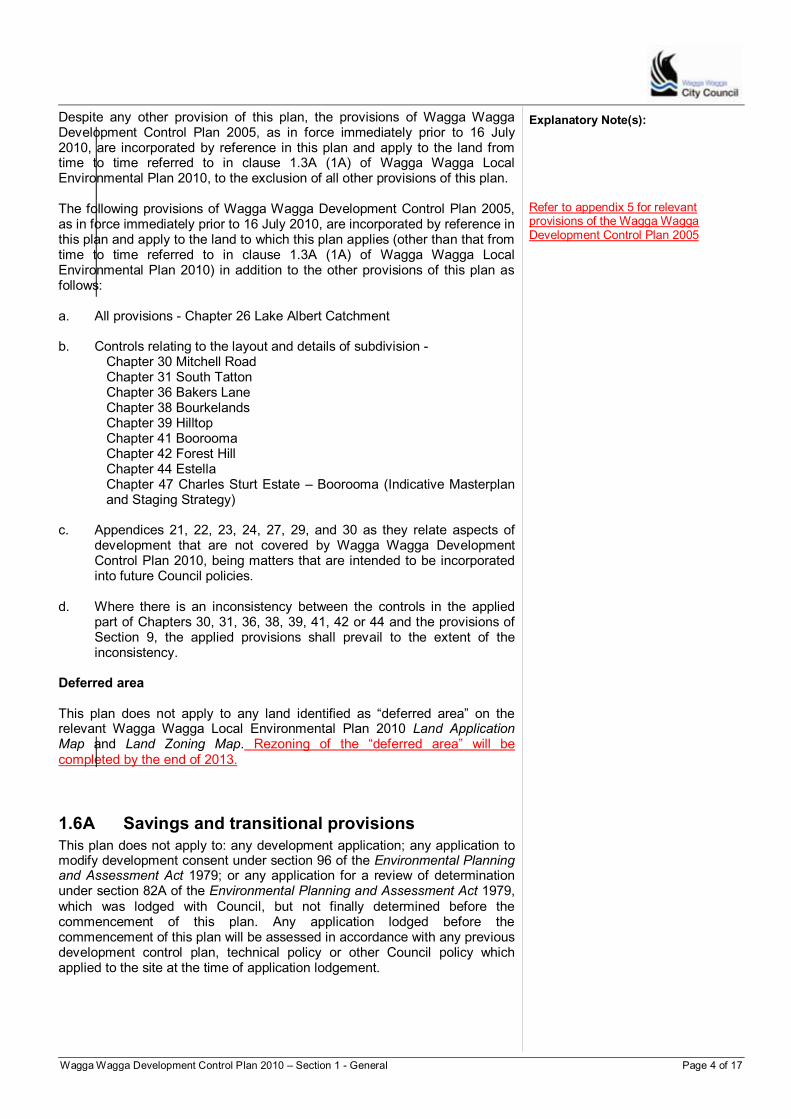
Despite any other provision of this plan, the provisions of Wagga Wagga Development Control Plan 2005, as in force immediately prior to 16 July 2010, are incorporated by reference in this plan and apply to the land from time to time referred to in clause 1.3A (1A) of Wagga Wagga Local Environmental Plan 2010, to the exclusion of all other provisions of this plan. The following provisions of Wagga Wagga Development Control Plan 2005, as in force immediately prior to 16 July 2010, are incorporated by reference in this plan and apply to the land to which this plan applies (other than that from time to time referred to in clause 1.3A (1A) of Wagga Wagga Local Environmental Plan 2010) in addition to the other provisions of this plan as follows: a. All provisions - Chapter 26 Lake Albert Catchment b. Controls relating to the layout and details of subdivision -
Chapter 30 Mitchell Road Chapter 31 South Tatton Chapter 36 Bakers Lane Chapter 38 Bourkelands Chapter 39 Hilltop Chapter 41 Boorooma Chapter 42 Forest Hill Chapter 44 Estella Chapter 47 Charles Sturt Estate – Boorooma (Indicative Masterplan and Staging Strategy)
c. Appendices 21, 22, 23, 24, 27, 29, and 30 as they relate aspects of development that are not covered by Wagga Wagga Development Control Plan 2010, being matters that are intended to be incorporated into future Council policies.
d. Where there is an inconsistency between the controls in the applied
part of Chapters 30, 31, 36, 38, 39, 41, 42 or 44 and the provisions of Section 9, the applied provisions shall prevail to the extent of the inconsistency.
Deferred area This plan does not apply to any land identified as “deferred area” on the relevant Wagga Wagga Local Environmental Plan 2010 Land Application Map and Land Zoning Map. Rezoning of the “deferred area” will be completed by the end of 2013.
1.6A Savings and transitional provisions
This plan does not apply to: any development application; any application to modify development consent under section 96 of the Environmental Planning and Assessment Act 1979; or any application for a review of determination under section 82A of the Environmental Planning and Assessment Act 1979, which was lodged with Council, but not finally determined before the commencement of this plan. Any application lodged before the commencement of this plan will be assessed in accordance with any previous development control plan, technical policy or other Council policy which applied to the site at the time of application lodgement.
Explanatory Note(s):
Refer to appendix 5 for relevant provisions of the Wagga Wagga Development Control Plan 2005
Wagga Wagga Development Control Plan 2010 – Section 1 - General Page 5 of 17
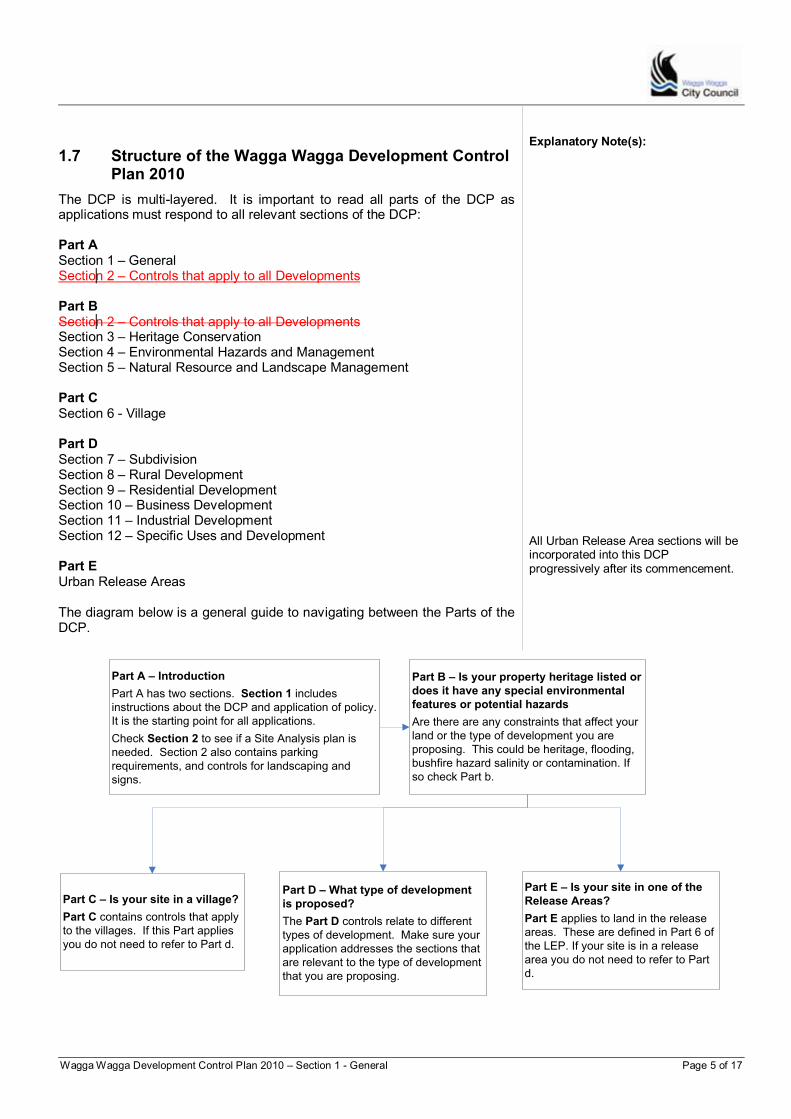
1.7 Structure of the Wagga Wagga Development Control Plan 2010
The DCP is multi-layered. It is important to read all parts of the DCP as applications must respond to all relevant sections of the DCP: Part A Section 1 – General Section 2 – Controls that apply to all Developments Part B Section 2 – Controls that apply to all Developments Section 3 – Heritage Conservation Section 4 – Environmental Hazards and Management Section 5 – Natural Resource and Landscape Management Part C Section 6 - Village Part D Section 7 – Subdivision Section 8 – Rural Development Section 9 – Residential Development Section 10 – Business Development Section 11 – Industrial Development Section 12 – Specific Uses and Development Part E Urban Release Areas
Explanatory Note(s):
All Urban Release Area sections will be incorporated into this DCP progressively after its commencement.
The diagram below is a general guide to navigating between the Parts of the DCP.
Part A – Introduction
Part A has two sections. Section 1 includes
instructions about the DCP and application of policy.
It is the starting point for all applications.
Check Section 2 to see if a Site Analysis plan is
needed. Section 2 also contains parking
requirements, and controls for landscaping and
signs.
Part B – Is your property heritage listed or
does it have any special environmental
features or potential hazards
Are there are any constraints that affect your
land or the type of development you are
proposing. This could be heritage, flooding,
bushfire hazard salinity or contamination. If
so check Part b.
Part C – Is your site in a village?
Part C contains controls that apply
to the villages. If this Part applies
you do not need to refer to Part d.
Part D – What type of development
is proposed?
The Part D controls relate to different
types of development. Make sure your
application addresses the sections that
are relevant to the type of development
that you are proposing.
Part E – Is your site in one of the
Release Areas?
Part E applies to land in the release
areas. These are defined in Part 6 of
the LEP. If your site is in a release
area you do not need to refer to Part
d.
Wagga Wagga Development Control Plan 2010 – Section 1 - General Page 6 of 17
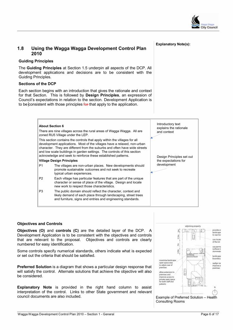
1.8 Using the Wagga Wagga Development Control Plan 2010
Guiding Principles
The Guiding Principles at Section 1.5 underpin all aspects of the DCP. All development applications and decisions are to be consistent with the Guiding Principles.
Sections of the DCP
Each section begins with an introduction that gives the rationale and context for that Section. This is followed by Design Principles, an expression of Council’s expectations in relation to the section. Development Application is to be consistent with those principles for that apply to the application.
Explanatory Note(s):
About Section 6
There are nine villages across the rural areas of Wagga Wagga. All are
zoned RU5 Village under the LEP.
This section contains the controls that apply within the villages for all
development applications. Most of the villages have a relaxed, non-urban
character. They are different from the suburbs and often have wide streets
and low scale buildings in garden settings. The controls of this section
acknowledge and seek to reinforce these established patterns.
Village Design Principles
P1 The villages are non-urban places. New developments should
promote sustainable outcomes and not seek to recreate
typical urban experiences.
P2 Each village has particular features that are part of the unique
character or sense of place of the village. Design and locate
new work to respect those characteristics.
P3 The public domain should reflect the character, context and
likely demand of each place through landscaping, street trees
and furniture, signs and entries and engineering standards.
Introductory text
explains the rationale
and context
Design Principles set out
the expectations for
development
Objectives and Controls
Objectives (O) and controls (C) are the detailed layer of the DCP. A Development Application is to be consistent with the objectives and controls that are relevant to the proposal. Objectives and controls are clearly numbered for easy identification.
Some controls specify numerical standards, others indicate what is expected or set out the criteria that should be satisfied.
Preferred Solution is a diagram that shows a particular design response that will satisfy the control. Alternate solutions that achieve the objective will also be considered.
Explanatory Note is provided in the right hand column to assist interpretation of the control. Links to other State government and relevant council documents are also included.
Example of Preferred Solution – Health Consulting Rooms
Wagga Wagga Development Control Plan 2010 – Section 1 - General Page 7 of 17
1.9 Lodging a Development Application
Pre-lodgement meetings Applicants are encouraged to seek advice from Council prior to lodging a Development Application by contacting the Council customer service centre to arrange a pre-lodgement meeting.
Explanatory Note(s):
For more information regarding the DA process refer to the Council’s Development Application Preparation & Lodgement Guide available at the Council’s Administration Building or from the Council’s website: http://www.wagga.nsw.gov.au There are some works and forms of development that do not require a development application. These Exempt and Complying developments are not addressed in this DCP, but separately in State Environmental Planning Policies (SEPP) available on the website; www.legislation.nsw.gov.au
Standard submission requirements The Environmental Planning and Assessment Act 1979 (the Act) and associated regulations specify documentation required with all development applications. These are required by law. Missing or incomplete documentation can delay processing development application.
Development Application Guide The Development Application Preparation and Lodgement Guide (the Guide) and checklists are available from the Council customer service centre. The Guide sets out all the information required to be provided in relation to a Development Application.
1.10 Notification of a Development Application
Public participation is an important component of the development assessment process to ensure that public participation occurs in an orderly, consistent and transparent manner.
Objectives
O1 Provide a framework for the notification and advertisement of development applications, applications to modify development consents and the review of development determinations.
O2 Provide an opportunity for public participation in the development application process.
O3 Establish a clear process whereby public views are considered in the development application process.
O4 Specify circumstances where notification and advertising of

Wagga Wagga Development Control Plan 2010 – Section 1 - General Page 8 of 17
applications is not required.
O5 Identify development applications that will be notified and/or advertised and those persons whothat will be notified.
O6 Facilitate the efficient processing of applications without unreasonably compromising the opportunity for public participation.
Minimum Standard
These provisions set the minimum level for neighbour and stakeholder notification. There may be occasions when these minimum provisions are increased at the discretion of the Council, taking into account the possible impact of an application. That is, where notification and/or advertising is required to occur it will always occur to the minimum requirements of the DCP. However, on occasions the notification may extend beyond the minimum number of properties and or the advertising and notification period may be extended.
Development not requiring notification
Some forms of residential development are of a natures which does not warrant notification by virtue of theirits minor nature, minimal or low environmental, social and economic impact orand high degree of compliance with Councils LEP and DCP.
Development that will not be notified is as follows:
1. Dwelling houses and additions to dwelling houses that:
(i) are within the R1, R3 and R5 zones and that are consistent with the primary purpose of the zoning;
(ii) are single storey;
(iii) comply with Council's building line setbacks and the relevant objectives and controls in the DCP
1;
(iv) comply with the Building Code of Australia, unless walls are built closer than 900 mm to the boundary, and
(v) have no other dwelling houses located on the same allotment.
1 Applications of the type referred to in 1 above not complying with relevant
objectives and controls in the DCP will be notified (Type A) for a period of 7 days.
Advertising and Notification Periods
The time period(s) for advertising and notification are set by the Act, as follows:
Explanatory Note(s):
Development category Advertising and notification period
Designated Development1 30 days
Remediation Requiring Consent1 30 days
Nominated Integrated Development1 30 days
Other advertised development2 7 days
3/14 days,
as indicated below
Wagga Wagga Development Control Plan 2010 – Section 1 - General Page 9 of 17
Exempt or Complying Development Not required Development not requiring notification Not required 1 Public participation requirements for designated development,
remediation requiring consent and nominated integrated development are set by legislation and therefore time periods may be subject to change if the legislation changes.
2 The notification of other forms of integrated development will only be
required where triggered by the table for “Other Advertised/Notified Development”.
3
The 7 day period for certain specified advertised development may be extended at the discretion of Council depending on the circumstances of the particular development or as considered appropriate in the public interest.
Wagga Wagga Notification Type A and B
Notification types A and B are the categories for minimum notification requirements. The extent of notification may be increased where the Council is of the opinion that additional notification is required taking into consideration the potential impact of the proposal. The criteria to determine if additional notification is warranted include:
Views to and from the surrounding land and buildings
Potential overshadowing of surrounding land and buildings
Potential impact on privacy of surrounding land and buildings
Potential noise, odour and vibration emissions to the surrounding land and buildings
Explanatory Note(s):
The likely visual impact of the proposed development in relation to the streetscape and views to and across the site
Potential traffic generation
Potential light-spill or reflection.
Notification Type A:
Immediately adjoining properties at the side and rear. For properties in an urban context, properties directly opposite the frontage of the development site in the street or rear lane.
Notification Type B: Three properties either side of the development site and three immediately adjoining at the rear plus three directly opposite the frontage of the development site in the street or rear lane.

Wagga Wagga Development Control Plan 2010 – Section 1 - General Page 10 of 17
Development requiring notification
Application Type Advertised Notification
Type Notification
Period (days)
RESIDENTIAL ZONE
New dwelling or major alterations and additions to a dwelling house including a new storey or part storey, a major rear or side extension
A 7
First floor balcony or deck
A 7
Construction of a swimming pool
A 7
Construction of a tennis court with lights
A 7
Construction of outbuildings
A 7
Secondary dwelling
B 14
Dual Occupancies Y B 14
Multi dwelling housing/residential flat buildings development
Y B 14
Major alterations and additions to any existing multi dwelling/residential flat building housing
A 14
Non Residential Development in the residential zone
Y B 14
BUSINESS ZONE
Erection of a new building
A 14
Alterations and additions to a commercial or retail building
A 14
Change of use to licenced premises Y B 14
Residential development in a business zone Y B 14
Non Business Development in the business zone
Y B 14
New Licenced Premises Y B 14
INDUSTRIAL ZONE
Erection of a new building
A 14
Alterations and additions to a industrial building
A 14
Change of use A 14
Non Industrial Development in the industrial zone
Y B 14
Wagga Wagga Development Control Plan 2010 – Section 1 - General Page 11 of 17
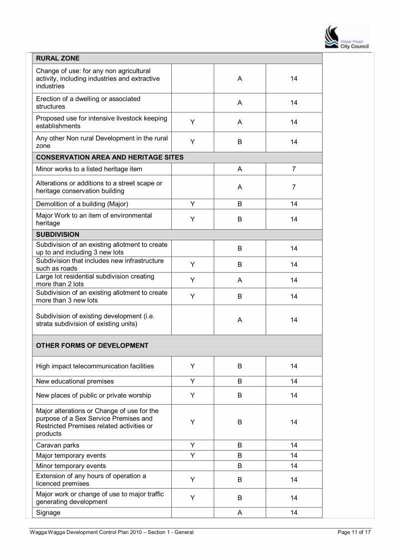
RURAL ZONE
Change of use: for any non agricultural activity, including industries and extractive industries
A 14
Erection of a dwelling or associated structures
A 14
Proposed use for intensive livestock keeping establishments
Y A 14
Any other Non rural Development in the rural zone
Y B 14
CONSERVATION AREA AND HERITAGE SITES
Minor works to a listed heritage item
A 7
Alterations or additions to a street scape or heritage conservation building
A 7
Demolition of a building (Major) Y B 14
Major Work to an item of environmental heritage
Y B 14
SUBDIVISION
Subdivision of an existing allotment to create up to and including 3 new lots
B 14
Subdivision that includes new infrastructure such as roads
Y B 14
Large lot residential subdivision creating more than 2 lots
Y A 14
Subdivision of an existing allotment to create more than 3 new lots
Y B 14
Subdivision of existing development (i.e. strata subdivision of existing units)
A 14
OTHER FORMS OF DEVELOPMENT
High impact telecommunication facilities Y B 14
New educational premises Y B 14
New places of public or private worship Y B 14
Major alterations or Change of use for the purpose of a Sex Service Premises and Restricted Premises related activities or products
Y B 14
Caravan parks Y B 14
Major temporary events Y B 14
Minor temporary events
B 14
Extension of any hours of operation a licenced premises
Y B 14
Major work or change of use to major traffic generating development
Y B 14
Signage
A 14
Wagga Wagga Development Control Plan 2010 – Section 1 - General Page 12 of 17
Procedures
Advertising procedures
C1 Development that is advertised will have a notice that describes the development placed in the local daily newspaper.
C2 The notification period for all advertised development commences one day after the date on which the notice first appears in the paper.
Explanatory Note(s):
C3 The newspaper advertisement is to contain the following information: a. a brief description of the proposal that outlines the nature and
purpose of the application
b. the address of the proposed development
c. the name of the applicant
d. the application reference number
e. the relevant council assessment officer to contact and contact details
f. where the application may be inspected and the times of inspection
g. the period during which submissions may be made
h. Council contact details for the purpose of making a submission
i. A statement that any person may make a written submission in relation to the development application
j. A statement that any person making a submission by way of objection must specify the grounds of objection
k. A statement outlining the privacy rights of any person making a submission to the Council
Explanatory Note(s):
Notification procedures
C4 Notification letters will be sent to current land owners (if their mailing address is known to Council). A single generic letter addressed to “the occupier” will also be posted to the street address for each allotment. relevant building owners and occupiers.
C5 For strata title buildings, notification will be sent to the Owners Corporation, the owners of strata units (where a mailing address is known to Council) and occupiers of the units. (if its mailing address is known to Council), the current owners of strata units (if their mailing address is known to Council). A single generic letter addressed to “the occupier” will also be posted to the street address for each strata allotment.
C5C6 For land where Council is aware that multiple tenants occupy the same land, and the land is not subdivided in any way, notification letters will be sent to the current land owner (if their mailing address is known to Council), and a single generic letter, addressed to “the occupier”, will be posted to the street address. Individual letters will not be posted to each separate tenant, and it will be the responsibility of the current land owner to notify each tenant of the proposed development.
Notification procedures
C6C7 The notification letters are to contain the following information:
a. the date of the letter
b. the name of the applicant
Wagga Wagga Development Control Plan 2010 – Section 1 - General Page 13 of 17
c. a brief description of the proposal that outlines the nature and purpose of the application
d. the address of the proposed development
e. the application reference number
f. the relevant council assessment officer to contact and contact details
g. where the application may be inspected and the times of inspection
h. the period during which submissions may be made
i. Council contact details for the purpose of making a submission
j. A statement that any person may make a written submission in relation to the development application
k. A statement that any person making a submission by way of objection must specify the grounds of objection
l. A statement outlining the privacy rights of any person making a submission to the Council
m. A statement outlining the officer delegations to assess and determine relevant applications.
C7C8 A notification sign advising of the proposed development will be erected on the subject site in cases where the application is advertised development.
Amendments, modifications and reviews
C8C9 When an application is amended prior to being determined by the Council it will be re-notified and re-advertised (if previously advertised) where the amended application is considered likely to result in additional environmental impacts.
C9C10 Amended applications that result in a reduction in the environmental impacts of a development are not required to be re-notified or re-advertised.
Modifying consents
An application to modify a development consents are known as a Section 96 application. There are three types of Section 96 applications:
Section 96(1) – an application involving correction of minor errors or mis-descriptions
Amendments, modifications and reviews
C10C11 An applicant may apply to modify a development consent that has been granted by Council provided the development remains substantially the same as the development originally approved. Only applications made under Section 96(2) will be notified, consistent with the original application, and if relevant advertised as well.
Section 96(1A) – an application involving minor environmental impacts
Section 96(2) – an application seeking other modifications
Explanatory Note(s):
C11C12 As a minimum, Section 82A applications to review a previously determined development application will require re-notification to those people who may have previously made submissions to the original application.
C12C13 Where a Section 82A application is likely to have a greater impact than the originally approved application the review application will be notified, and if relevant advertised, in the same manner as the original application.
Process following receipt of submissions
1. Submissions in relation to development applications, Section 96 applications and Section 82A applications must be in writing (or by email) for the Council to take them into account in assessing and determining an application.
Review of determination
An applicant may request the Council to review their decision on a Development Application. Most commonly these applications, known as Section 82A
Wagga Wagga Development Control Plan 2010 – Section 1 - General Page 14 of 17
2. Submissions received by the Council will be available for public inspection upon request. Submissions will not be kept confidential, although the names and addresses of writers will be kept confidential if so requested in writing.
3. Submissions will be formally acknowledged in writing by the Council.
4. Applications will be assessed by the Council taking into account all submissions received. Applications can then be determined in a number of ways under delegated authority or by the Councillors at a Council Meeting or by the Wagga Wagga City Council Interim Joint Planning Panel or the Southern Joint Regional Joint Planning Panel. Where the number of submissions received in response to an advertised or notified development application is 10 or more, the application will be referreed to Council for determination. Objections will continue to be considered on the basis of merit and relevance. Any group of pro-forma objections will be considered s one objection only.
5. If an application is to be considered by the Council those people who have made a written submissions, together with the applicant, will be advised either in writing, telephone or email of the meeting at which the application is to be considered.
6. Those people that have made a submission(s) will be advised in writing of the Council’s decision regarding the application.
applications, are in response to either a refusal or conditions that may have been placed on the consent where it has been approved.
1.11 Complying with the Wagga Wagga Development Control Plan 2010
The controls in the DCP support the Guiding Principles of the Pplan and principles and objectives contained within the various sections. Except as varied elsewhere in this Plan, all Development Applications, Section 96 Applications and Section 82A Applications must should aim to satisfy all stated objectives and controls.
Whilst all developments should aim to satisfy all controls within the DCP, it is acknowledged that there may be circumstances prevailing where it may not be possible to achieve strict compliance.
Council may consent to an application which departs from any control, whether a “numeric” or non-numeric control. In such cases, a written submission must be lodged with the Development Application, which states the following:
1. The relevant control(s) and each section of the DCP that is the subject of the request.
2. The extent of each variation (noting that a control may be numeric or non-numeric).
3. Reasons to support the variation. This may include a written statement with diagrams, photographs, sections, plans, or letters from adjoining owners if appropriate. The reasons should be related to demonstrating the following:
Whether non-compliance will pre-judice the objectives of the zone and the aims of the DCP.
Conformity with both the provisions of the DCP and conformity with the aims and objectives of zones in WWLEP 2010.
Explanatory Note(s):

Wagga Wagga Development Control Plan 2010 – Section 1 - General Page 15 of 17
What aspects of the development do not meet the DCP requirements?
To what degree does the proposal depart from the DCP?
How the objective(s) is met if the control is to be varied?
Justification for the departure in terms of the above circumstances.
Some of the factors or criteria Council will consider in determining whether a departure from the DCP is warranted include:
Whether there will be any detrimental impact on the amenity of the existing and future residents/occupants, as well as, its surrounds.
The nature and magnitude of the departure.
The degree of compliance with other relevant controls, objectives and principles and any compensatory measures proposed to offset the departure.
The circumstances of the case, including whether the particular control(s) is unreasonable and/or unnecessary.
Priorities identified in a site analysis being of greater importance than what is being departed from.
Whether non-compliance will prejudice the objectives of the zone and the aims of the DCP.
79C of the Environmental Planning and Assessment Act 1979 - matters for consideration in the determination of a development application.
Where an development application involves the variation of one or more controls within the DCP Council staff have delegation to approve variations but limited to the following circumstances;
Where adequate justification is provided for the number of controls being variesd and/or,
Where any numeric control is not being varied by greater than 10% and
Where the number of submissions received in response to an advertised or notified development application, is less than 10.
Wagga Wagga Development Control Plan 2010 – Section 1 - General Page 16 of 17
1.12 Where can I get more information?
For further information about the DCP, please contact:
Council’s customer service centre on – 1300 292 442
Council’s website – www.wagga.nsw.gov.au
Email – [email protected]
For further information regarding the lodgement and process followed for development applications please refer to the Council’s Development Application Preparation & Lodgement Guide: http://www.wagga.nsw.gov.au/__data/assets/pdf_file/0020/16580/DA-Guide-V1.6.pdf
Useful inks:
For more information regarding the Environmental Planning and Assessment Act 1979 and Environmental Planning and Assessment Regulation 2000 visit the NSW legislation website - www.legislation.nsw.gov.au
NSW Department of Planning and Infrastructure – www.planning. nsw.gov.au
Southern Region Joint Planning Panel - http://jrpp.planning.nsw.gov.au
Explanatory Note(s):

Wagga Wagga Development Control Plan 2010 – Section 1 - General Page 17 of 17

Wagga Wagga Development Control Plan 2010 – Section 2 – Controls that apply to all developments Page 1 of 19
Part AB
Section 2 Controls that apply to all development
Table of Contents 2.1 Site Analysis Plan ............................................................................. 2
2.2 Vehicle access and movements ....................................................... 2 2.3 Off-street parking .............................................................................. 3
2.4 Landscaping ..................................................................................... 6 2.5 Signage ............................................................................................ 7
2.6 Safety and security ......................................................................... 14 2.7 Changing the landform – cut and fill ............................................... 15
2.8 Erosion and Sediment Control Principles ....................................... 17 2.9 Development adjoining open space ................................................ 18
Wagga Wagga Development Control Plan 2010 – Section 2 – Controls that apply to all developments Page 2 of 19
2.1 Site Analysis Plan
Good design is based on an understanding of the particular characteristics and context of the site. This helps new developments make the best of the site and are considerate of neighbours and the locality.
A good site analysis is facilitated by a plan. It is a concept plan that shows the constraints and opportunities of the site, often using the site plan as a base, as well as illustrating and analysing existing site conditions in relation to surrounding land and buildings. The site analysis plan is drawn at a standard scale such as 1:100 or 1:200 or for larger proposals 1:500.
Objectives
O1 Encourage development that is responsive to site constraints and opportunities, and the surrounding context.
O2 Complement and reinforce Councils Development Application Preparation and Lodgement Guide (the Guide) and Checklists.
Site analysis requirements
C1 A site analysis plan is required for applications that propose substantial new work or construction but may not be necessary for applications that only involve minor construction, work or changes to a building – refer to explanatory note opposite.
C2 A site analysis plan is to incorporate a range of details in relation to a number of elements specified in the Guide, including:
a. Orientation and local solar context.
b. Property details.
c. Landform and vegetation.
d. Access.
e.a. Heritage context.
Explanatory Note(s): If you are uncertain whether a site analysis plan is required for your application, refer to the Council Development Application Preparation and Lodgement Guide (the Guide) and Checklists or contact the customer service centre. Applications that require a Site Analysis Plan include applications for : Commercial and Industrial development Residential development (including dual
occupancy, multi-dwellings and the like) Subdivision
Also refer to the Guide for list of exemptions.
Complying with this DCP
The controls in the DCP support the Guiding Principles and Section Objectives. A Development Application must should aim to satisfy the Guiding Principles, and the Objectives of the relevant sections. Equal emphasis must be given to both "numeric" and non-numeric controls relevant to a particular development. Where a proposed development has an unacceptable impact on neighbours or the surrounding environment cCompliance with controls will not necessarily guarantee approval of an application.
Where a variation is sought to controls, the application must document the reasons and extent of the variation, and how the variation meets the Guiding Principles and Section Objectives for the consideration of the Council.
2.2 Vehicle access and movements
This section contains controls to ensure the safe and efficient operation of roads within the local government area of Wagga Wagga.
Objectives
O1 Ensure the safety and efficiency of urban and rural roads.
O2 Limit new access points to arterial roads or ensure alternative access is utilised where practical.
New roads and access points to arterial roads normally require separate approval from the NSW Roads and Maritime Services. and Traffic Authority
Controls
C1 Access should be from an alternative secondary frontage or other non-arterial road where possible.
C2 A Traffic Impact Study may be required where adverse local traffic impacts may result from the development. The traffic impact study is to include the suitability of the proposal in terms of the design and location of the proposed access, and the likely nature, volume or frequency of traffic to be generated by the development.
Formatted: No bullets or numbering
Wagga Wagga Development Control Plan 2010 – Section 2 – Controls that apply to all developments Page 3 of 19
C3 Vehicles are to enter and leave in a forward direction unless it can be demonstrated that site conditions prevent it.
C4 Provide adequate areas for loading and unloading of goods on site. The loading space and facilities are to be appropriate to the scale of development.
C5 Access driveways are not to be located opposite T-intersections or within 7m of a break in a median strip or intersection.
C6 Ensure adequate sight lines for proposed driveways.
Explanatory Note(s):
The control regarding vehicles entering and leaving in a forward direction applies to development with common driveways.This control does not apply to single dwellings or where access is from a rear lane.
Design to ensure adequate turning and manoeuvring for all vehicles that are likely to visit and service the siteincluding trucks.
2.3 Off-street parking
Developments are required to provide off-street parking to meet anticipated demands. This section sets out the rates for provision of off street parking.
The minimum parking requirements are shown in Table 1 on page 4 of 19. The requirement(s) can only be varied where adequate justification is provided and supported during assessment of the Development Application.
Objectives
O1 Ensure adequate provision is made for safe and efficient movement of vehicles and pedestrians.
O2 Ensure the provision of safe and efficient parking for all modes of transport to meet anticipated demands.
O3 Minimise disruptions to existing levels of service and safety as a result of insufficient parking being provided on site.
O4 Soften the impacts of larger car parking areas through the use of landscaping.
O5 Provide both shade and solar access to car park users by means of purpose designed tree planting.
Controls – parking rates
C1 Parking is to be provided in accordance with the table below. For uses not listed, similar land uses should be used as a guide in assessing car parking requirements.
C2 The design and layout of parking is to be in accordance with the relevant Australian Standard at the time of lodgement of an application. AS 2890.1-2004.
C3 Parking spaces are to be provided for disabled persons. Accessible parking spaces to comply with the relevant Australian Standard at the time of lodgement of an application. AS 2890.1-1993.
C4 For all uses other than single dwellings vehicles are to enter and leave the site in a forward motion unless it can be demonstrated that site conditions prevent it.
C5C3 For mixed use developments, the parking required is the total of requirements for each use. Variations can be considered where it can be demonstrated that the peak demand for each land use component is staggered or that development as a whole generates less parking than separable parts.
C6C4 In the case of redevelopment or change of use (other than in the B3 zone) the parking requirements are to be calculated by:
a. Determining the parking requirement of the current or previous use in accordance with the table, then
Council may accept a car parking contribution in lieu of car parking spaces that cannot be provided on site by a particular development within the city centre.
All Australian and New Zealand standards as well as some international standards are available on www.saiglobal.com/shop
The number of parking spaces is determined by the Building Code of Australia (BCA) as in force at the time of lodgement of the application.
Online access to the Building Code of Australia as well as regulatory impact statements relating to building is available on www.abcb.gov.au

Wagga Wagga Development Control Plan 2010 – Section 2 – Controls that apply to all developments Page 4 of 19
b. Determining the parking requirement for the new use, then
c. Subtracting the existing requirement from the requirement for the proposed use to determine the required number of spaces required (i.e. a credit is provided for any shortfall that exists on the site for the current use).
C7C5 In the case of redevelopment or change of use within the B3 zone where there is no increase in gross floor area, no additional spaces will be required, except in the following instances: Outbuildings are proposed to be used in association with the
development Or
A Traffic Impact Assessment (TIA) is required by Council for the development.
C8C6 A traffic and parking study may be required for certain proposals, including but not limited to proposals for schools and other education uses including child care centres, business parks, hospitals, cinemas and gyms.
C9C7 Provide trees within the parking area at a rate of 1 tree per 5 spaces in a row. Each tree to have a minimum mature spread of 5m and to be located in a planting bed with minimum width of 1.5m (between back of kerbs) and minimum area of 3.5m2.
C10C8 Planting beds located within a car park are to have a subsoil drainage system connected into the stormwater system of the site.
C11C9 To ensure sightlines are maintained for drivers and pedestrians, trees used within or adjacent to car parking areas shall have a minimum clear trunk height of 2.5m, with shrubs and ground covers not to exceed 500mm in height.
Explanatory Note(s):
When new development applications are lodged, existing developments with car parking spaces do not benefit from amendments to car parking standards.
This control applies to all non-residential development.
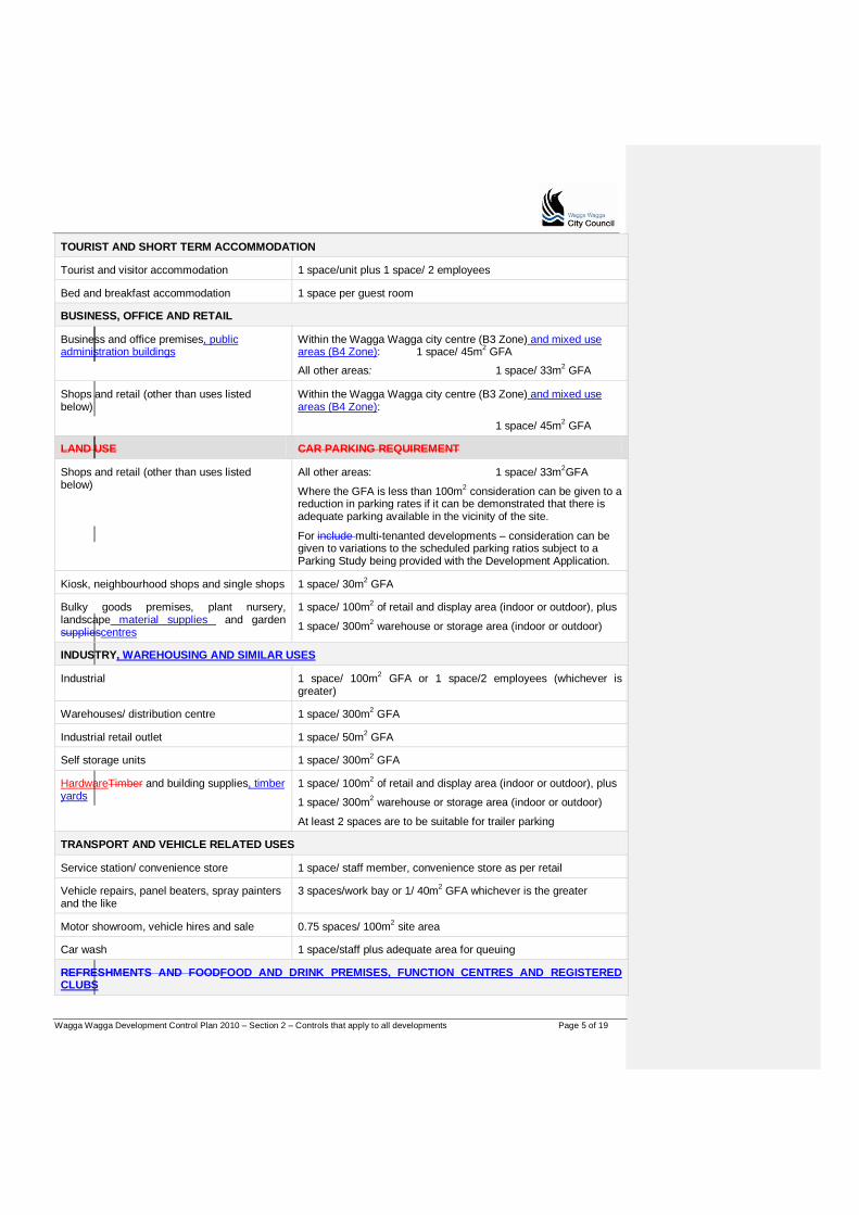
Table 1
LAND USE CAR PARKING REQUIREMENT
RESIDENTIAL ACCOMMODATION
Dwelling house, dual occupancy, attached dwellings, semi-detached dwellings
1 space/2 bedroom house
1 spaces/3 bedroom or larger house
Multi-dwelling housing/space medium density units
1 space/1 bedroom dwelling
1.5 spaces/2 bedroom dwelling
2 spaces/3 or more bedrooms or larger dwelling
Visitor spaces – 1 per 4 dwellings where there are more than 4 dwellings (1 space required per 5-7 dwellings, 2 spaces per 8-11 dwellings,etc.)
Residential flat buildings 1 space/1 or 2 bedroom unit
2 spaces/3 bedroom or larger unit
Visitor spaces – 1/5 units where there are more than 5 units
Seniors livinghousing In accordance with the SEPP (Housing for Seniors or People with a DisabilitySeniors Living) 2004
Wagga Wagga Development Control Plan 2010 – Section 2 – Controls that apply to all developments Page 5 of 19
TOURIST AND SHORT TERM ACCOMMODATION
Tourist and visitor accommodation 1 space/unit plus 1 space/ 2 employees
Bed and breakfast accommodation 1 space per guest room
BUSINESS, OFFICE AND RETAIL
Business and office premises, public administration buildings
Within the Wagga Wagga city centre (B3 Zone) and mixed use areas (B4 Zone): 1 space/ 45m2 GFA
All other areas: 1 space/ 33m2 GFA
Shops and retail (other than uses listed below)
Within the Wagga Wagga city centre (B3 Zone) and mixed use areas (B4 Zone):
1 space/ 45m2 GFA
LAND USE CAR PARKING REQUIREMENT
Shops and retail (other than uses listed below)
All other areas: 1 space/ 33m2GFA
Where the GFA is less than 100m2 consideration can be given to a reduction in parking rates if it can be demonstrated that there is adequate parking available in the vicinity of the site.
For include multi-tenanted developments – consideration can be given to variations to the scheduled parking ratios subject to a Parking Study being provided with the Development Application.
Kiosk, neighbourhood shops and single shops 1 space/ 30m2 GFA
Bulky goods premises, plant nursery, landscape material supplies and garden suppliescentres
1 space/ 100m2 of retail and display area (indoor or outdoor), plus
1 space/ 300m2 warehouse or storage area (indoor or outdoor)
INDUSTRY, WAREHOUSING AND SIMILAR USES
Industrial 1 space/ 100m2 GFA or 1 space/2 employees (whichever is greater)
Warehouses/ distribution centre 1 space/ 300m2 GFA
Industrial retail outlet 1 space/ 50m2 GFA
Self storage units 1 space/ 300m2 GFA
HardwareTimber and building supplies, timber yards
1 space/ 100m2 of retail and display area (indoor or outdoor), plus
1 space/ 300m2 warehouse or storage area (indoor or outdoor)
At least 2 spaces are to be suitable for trailer parking
TRANSPORT AND VEHICLE RELATED USES
Service station/ convenience store 1 space/ staff member, convenience store as per retail
Vehicle repairs, panel beaters, spray painters and the like
3 spaces/work bay or 1/ 40m2 GFA whichever is the greater
Motor showroom, vehicle hires and sale 0.75 spaces/ 100m2 site area
Car wash 1 space/staff plus adequate area for queuing
REFRESHMENTS AND FOODFOOD AND DRINK PREMISES, FUNCTION CENTRES AND REGISTERED CLUBS

Wagga Wagga Development Control Plan 2010 – Section 2 – Controls that apply to all developments Page 6 of 19
Restaurants, cafes, hotelspubs, clubs and function rooms
Within the Wagga Wagga city centre: 1 space/ 25m2 GFA All other areas: 1 space/ 10m2 GFA or 1 space/ 3 seats whichever is greater
Take away food and drink premises 1 space/ 10m2 GFA or 1 space/ 3 seats where provided (whichever is greater)
HEALTH, EDUCATION AND COMMUNITY FACILITIES
Primary and secondary schools 1 space/ two employees plus 1 space/ ten senior students (Years 11 and 12)
Preschools, Kindergartens and childcare centres
1 space/ 4 children in attendance
Churches, places of worship/ assembly 1 space/ 4 seats or 1 space/ 10m2 GFA whichever is greater
Health and professional consulting rooms, medical centres and veterinary hospitals
3 spaces/ surgery or health care professional practising at any one
LAND USE CAR PARKING REQUIREMENT
time plus 1 space/ receptionist/ support staff
Hospital 1 space/ 25m2 GFA
Mortuary/funeral parlourhome 1 space/ 10 beds Plus
1 space/ 2 employees and 1 ambulance space
Nursing/Convalescent home As per State Environmental Planning Policy (Housing for Seniors or People with a Disability 2004)
RECREATION AND ENTERTAINMENT
Gymnasium, health and fitness centre 1 space/ 16m2 GFA
Bowling alley, squash courts, tennis courts 3 spaces/ court or alley
2.4 Landscaping
Landscaping is an important aspect of development, and complements good design. Trees, shrubs and green spaces can “soften” the impact of buildings, screen private spaces and create modified micro-climates. The importance of well designed landscaping is also increasing in the face of climate change, and is critical for attractive and useable outdoor spaces.
Objectives
Explanatory Note(s):
If uncertain whether a landscape plan is required consult the Development Application Preparation and Lodgement Guide (the Guide) and Checklists or contact the Council Planning staff via the Council customer service centre. Also refer to the Guide for the list of exemptions to these requirements.
O1 Promote designed landscapes as part of a fully integrated approach to site development within residential, industrial and commercial areas.
O2 Retain and protect existing vegetation, particularly large and medium trees, and conserve significant natural features of the site.
O3 Encourage landscape that responds to existing site conditions, local character and creates and enhances living and working environments whilst discouraging the opportunities for crime and vandalism.
O4 Ensure the landscape adequately complements the proposed built forms and minimises the impacts of scale, mass and bulk of
Applicants should note that Clause 5.9 of the LEP requires development consent for the lopping and removal of trees.

Wagga Wagga Development Control Plan 2010 – Section 2 – Controls that apply to all developments Page 7 of 19
the development on the existing area and surrounding streetscapes, view sheds and neighbourhood amenity.
O5 Promote the use of indigenous and other low maintenance plant material suitable to the climatic extremes of the local area, particularly the use of plant material with low water requirements.
O6 Encourage landscape that can be effectively maintained to a high standard for the life of the development.
O7 Enhance and define entry areas and to frame views from and into the development via the use of landscaping.
Controls – All developments
Landscape design
C1 A landscape plan is required for applications for : Commercial and Industrial developments Residential development (other than dwelling houses).
C2 Natural features at the site, such as trees, rock outcrops, cliffs, ledges and indigenous species and vegetation communities are to be retained and incorporated into the design of the development.
C3 Use native and indigenous plants, especially low water consumption plants in preference to exotic species.
C4 Trees should be planted at the front and rear of properties to provide tree canopy.
C5 Provide landscaping in the front and side setback areas, and on other parts of the site to improve the streetscape, soften the appearance of buildings and paved areas, and to provide visual screening.
C6 Landscaping should provide shade in summer without reducing solar access in winter. Limited use of deciduous species is acceptable where used to achieve passive solar design.
Explanatory Note(s):
Controls about the removal of trees are at Section 5.2 of the DCP.
Applications for other categories of developments as identified in the Guide may also require a landscape plan depending on the nature, scale and context of the proposed development.
Refer to the Guide for additional requirements.
Landscaped areas should be designed to require minimal maintenace by using robust landscape elements and hardy plants with low fertiliser requirements.
2.5 Signage
Background
Signs are an important part of the urban and rural environment. They are used to promote business and communicate information. The DCP encourages signs to complement their location, and not dominate or detract from the character of the area.
Approval and statutory framework
1. The display of signage and the erection of advertising structures are subject to the provisions of the LEP and whether such advertisements or advertising structures are permissible within a particular zone under the LEP.
2. The LEP contains Exempt and Complying Development provisions. Exempt development is a form of self-assessed development which can take place without the need for Council approval. Refer to Schedule 2 of the LEP. Refer also to the note opposite for exemptions specified under the Codes SEPP.
3. Under State Environmental Planning Policy No. 64 – Advertising and Signage (SEPP 64), the Council cannot grant consent to an advertising sign or structure unless it is consistent with the aims of the SEPP 64 and satisfies the assessment criteria listed in Schedule 1 of the SEPP 64 and any other requirements of the
A reference to signage includes a reference to building identification signs, business identification signs and advertisements.
Under State Environmental Planning Policy (Exempt and Complying Development Codes) 2008. (Codes SEPP) the replacement of:
(a) an existing building identification sign or the content of such a sign, or
(b) an existing business identification sign or the content of such a sign,
is exempt development. Refer to clause
Wagga Wagga Development Control Plan 2010 – Section 2 – Controls that apply to all developments Page 8 of 19
policy.
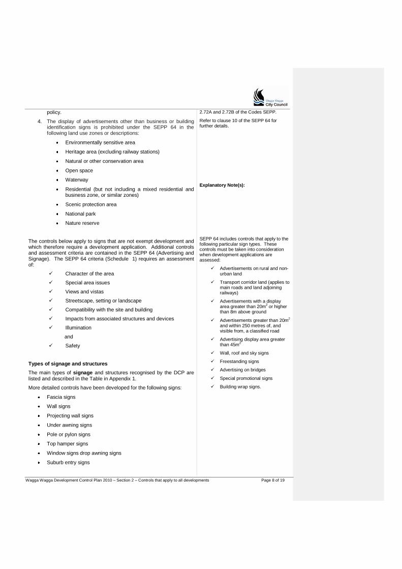
4. The display of advertisements other than business or building identification signs is prohibited under the SEPP 64 in the following land use zones or descriptions:
Environmentally sensitive area
Heritage area (excluding railway stations)
Natural or other conservation area
Open space
Waterway
Residential (but not including a mixed residential and business zone, or similar zones)
Scenic protection area
National park
Nature reserve
The controls below apply to signs that are not exempt development and which therefore require a development application. Additional controls and assessment criteria are contained in the SEPP 64 (Advertising and Signage). The SEPP 64 criteria (Schedule 1) requires an assessment of:
Character of the area
Special area issues
Views and vistas
Streetscape, setting or landscape
Compatibility with the site and building
Impacts from associated structures and devices
Illumination
and
Safety
Types of signage and structures
The main types of signage and structures recognised by the DCP are listed and described in the Table in Appendix 1.
More detailed controls have been developed for the following signs:
Fascia signs
Wall signs
Projecting wall signs
Under awning signs
Pole or pylon signs
Top hamper signs
Window signs drop awning signs
Suburb entry signs
2.72A and 2.72B of the Codes SEPP.
Refer to clause 10 of the SEPP 64 for further details.
Explanatory Note(s):
SEPP 64 includes controls that apply to the following particular sign types. These controls must be taken into consideration when development applications are assessed:
Advertisements on rural and non-urban land
Transport corridor land (applies to main roads and land adjoining railways)
Advertisements with a display area greater than 20m2 or higher than 8m above ground
Advertisements greater than 20m2 and within 250 metres of, and visible from, a classified road
Advertising display area greater than 45m2
Wall, roof and sky signs
Freestanding signs
Advertising on bridges
Special promotional signs
Building wrap signs.

Wagga Wagga Development Control Plan 2010 – Section 2 – Controls that apply to all developments Page 9 of 19
Council acknowledges that there may be some types or forms of signage and structures that do not fit neatly into the types recognised in the Table in Appendix 1, and in such instances such signs will be considered and determined on their merits in the context of the LEP, SEPP 64 and the DCP.
Main types of signage and structures that will not be permitted
The following types of signs will not be permitted within the local government area of Wagga Wagga:
1. Signage (other than business or building identification signs) that is prohibited under the SEPP 64 i.e. advertisements on land in the land use zones outlined in clause 10 of the SEPP 64. Refer to 4 above and Clause 10 of the SEPP 64.
2. Signage signs over 45m2.
3. A - Frame signs (other than “A – Frame” signs (or “advertising billboards”) permitted and approved by Council under its Street Activities on Footpath Policy POL 041.
Additional guidelines are contained in Council‟s Outdoor Eating and Display of Goods on Footpaths policies.
4. Roof top or sky signage.
5. Above awning signs.
6. Flashing, moving or variable message board signs (other than those installed and operated by an authorised Road Authority i.e. NSW Roads and Maritime Servicesand Traffic Authority or the Council for traffic management and or road safety purposes.
7. Signs resembling traffic management signage whether flashing, moving or not.
8. Permanently anchored balloons, blimps or any airborne signs.
9. Inflatable signs or structures (i.e. where displayed for greater than 14 days).
10. Hoarding signs (other than work safety signage), painted bulletins etc attached to the exterior of buildings, power poles, fences etc.
11. Signage that projects from a wall or are suspended from an awning at a height lower than 2.6 metres at any point above a footpath (except in the case of an under awning bracket sign or a drop awning sign).
12. Advertising signs or structures that do not comply with all applicable requirements of the BCA and relevant Australian Standards.
13. Third party advertising (i.e. general advertising not directly related to the approved use of the building or site).
Explanatory Note(s):
Objectives
O1 Complement the SEPP 64 and provide more detailed controls that reflect the environmental conditions and character of the local government are of Wagga Wagga.
O2 Support a consistent approach for signs and advertising across the local government are of Wagga Wagga.
O3 Allow reasonable opportunities for signs and advertising associated with business and tourism developments.
O4 Ensure signs do not detract from the urban or rural landscape.
Most sign applications are subject to State Environmental Planning Policy No 64 (Advertising and Signage). Applications are to address the assessment criteria at Schedule 1 of SEPP 64.
Wagga Wagga Development Control Plan 2010 – Section 2 – Controls that apply to all developments Page 10 of 19
O5 Minimise visual clutter from the proliferation of signs and advertising and from poor rationalisation of signs.
O6 Clarify where signs will not be supported or encouraged.
General controls for signage and structures
C1 All signage and structures must relate directly to the lawful approved or exempt land use being conducted on the land to which the signage or structure is to be displayed.
C2 Any sign or structure should reflect the architectural style of the building.
C3 Signs should not obscure decorative forms or moulding and should observe a reasonable separation distance from the lines of windows, doors, parapets, piers and the like.
C4 Signs should be of a size and proportion which complement the scale of the existing building as well as surrounding buildings and signs. Signs should not significantly affect the presentation of the existing façade of the building.
C5 The scale of lettering should also be proportioned to the area of the advertising panel to which it will be applied.
Explanatory Note(s):
When considering an application for signage, the assessment process will take into account the number of signs per building or site, as well as:
(a) The number of existing signs on the subject premises.
(b) The proportion of the solid (wall surface area) to void (window and door openings) available for signage.
(c) The length of frontage to the premises.
(d) The extent of the façade detail and projecting features of the building which should remain unobscured by signage; and
C6 The colour used in the design of a sign or structure should complement the colour finish of the building to which it will relate.
C7 Corporate colours should be limited to the signage or structure and should not be applied to the painted surface of the building.
C8 The illumination of signage and structures by low set floodlighting is preferred, rather than the use of neon or boxed fluorescent lighting on buildings.
(e) The number of tenancies/ occupancies per building.
C9 The rationalisation of signage will be generally required where there is existing signage through the use of common directory pylon signs for multi-occupancy developments and by limiting the number of signs that may be erected on any one building or site.
C10 Any new proposed or additional sign or structure should be off-set by the associated deletion of some other existing sign(s).
C11 A sign or structure must not endanger public safety or cause nuisance or a hazard by reason of its location, construction or design by either:
(a) Emitting excessive glare or reflection from internal or external illumination or surface materials;
(b) Obscuring the view of motorists or pedestrians;
(c) Screening potentially hazardous road features;
(d) Signage containing designs or messages which may either confuse or distract motorists.

Wagga Wagga Development Control Plan 2010 – Section 2 – Controls that apply to all developments Page 11 of 19
Specific controls for signage and structures
Fascia Signs
C12 Maximum of one (1) building identification sign per building awning.
C13 Maximum of one (1) business identification sign per tenancy or occupancy.
C14 Fascia signs must form part of the awning and must not project above or below the awning fascia.
C15 Fascia signs must not be illuminated.
C16 Fascia signs should include business identification (i.e. the name and general nature of the approved business carried out in the building or premises to which the fascia awning is attached).
Wall Signs
C17 Maximum of one (1) business identification sign per tenancy elevation.
C18 Maximum of one (1) building identification sign per building elevation.
C19 Must be integrated with the design of the building on which it is to be displayed and for a building having:
(a) An above ground elevation of 200m2 or more – the advertisement must not exceed 10% of the above ground elevation;
(b) An above ground elevation of more than 100m2, but less than 200 m2 – the advertisement must not exceed 20m2; and
(c) An above ground elevation of 100m2 or less – the advertisement does not exceed 20% of the above ground elevation.
C20 Must be attached flush to the wall and must not protrude more than 300mm from the wall.
C21 Must not protrude above the parapet or eaves.
C22 Must not cover mechanical ventilation vents.
C23 Must not extend over any window or other external opening.
C24 Must not obscure significant architectural elements of the building.
Projecting Wall Signs
C25 Maximum of one (1) business identification sign per tenancy elevation and the sign must be integrated with the design of the building on which it is to be displayed.
C26 Maximum of one (1) building identification sign per building elevation and the sign must be integrated with the design of the building on which it is to be displayed.
C27 Maximum panel area for a projecting wall sign is 2m2.
C28 Must not project more than 2.5metres from the edge of the building.
C29 Must have a minimum clearance of 2.6metres above ground level.
C30 Must not be located above the awning of the building.
Explanatory Note(s):
Wagga Wagga Development Control Plan 2010 – Section 2 – Controls that apply to all developments Page 12 of 19
C31 Must be securely fixed and maintained in a structurally adequate and safe manner.
Under Awning Signs
C32 Maximum of one (1) business identification sign per tenancy or occupancy that has direct frontage/exposure to the street.
C33 Maximum of one (1) building identification sign per building awning. A corner building with a wrap around awning is permitted a maximum of two (2) under awning signs.
C34 Must be attached to the underside of an awning and erected in a horizontal position at right angle to the building.
C35 A minimum clearance of 2.6metres is required between the underside of the sign and the footpath below.
C36 Must be setback at least 500mm from the footpath edge to the road carriageway.
C37 Must not project beyond the awning.
C38 Documentary evidence of the structural adequacy of the awning to support an under awning sign is to be provided to Council prior to the installation of the sign – such evidence is to be in the form of a certification from a practicing structural engineer.
Pole or Pylon Signs (including monolith style signs)
C39 Maximum of one (1) pole or pylon sign per street frontage.
C40 Minimum clearance of 2.6metres is required from the underside of the pole or pylon sign and the ground level, except where the sign structure is a monolith style accommodating a panel that reaches to or close to the ground.
C41 Maximum panel area (whether all used for advertising content or not) for a pole or pylon sign upon a site located within a business zone is 8m2 or 10m2 for a monolith style sign.
C42 Maximum height for a pole or pylon sign upon a site located within a business zone is 8metres above ground level, provided the height of the sign does not protrude above the dominant skyline (including any buildings, structures or tree canopy).
C43 Maximum panel area (whether all used for advertising content or not) for a pole or pylon sign upon land within an Industrial zone is 10m2, including monolith signs.
C44 Maximum height of a pole or pylon sign upon a site located within an Industrial zone is 8metres above ground level, provided the height of the sign does not protrude above the dominant skyline (including any buildings, structures or tree canopy).
C45 Maximum panel area (whether all used for advertising content or not) for a pole or pylon sign upon land within a rural zone is 4m2.
C46 Maximum height of a pole or pylon sign upon a site located within a rural zone is 4metres above ground level, provided the height of the sign does not protrude above the dominant skyline (including any buildings, structures or tree canopy).
C47 Will generally not be permitted upon a site located within a residential zone.
However, a pole or pylon sign may be permitted, in special cases where:
Explanatory Note(s):

Wagga Wagga Development Control Plan 2010 – Section 2 – Controls that apply to all developments Page 13 of 19
(a) The proposed sign is for advertising of an existing approved business; and
(b) The proposed sign (in the opinion of Council) will not cause any adverse visual impact upon the streetscape character or amenity of the residential locality and /or view loss to key views or vistas; and
(c) The maximum advertising area of the sign is 0.75m2 and the maximum height of the sign is 2m2, above ground level.
Top Hamper Signs
C48 Maximum of one (1) building identification sign permitted per building.
C49 Maximum of one (1) business identification sign permitted per tenancy or occupation, except where, in the opinion of Council, the building frontage is only of sufficient length to accommodate more than one (1) sign.
C50 May project up to 200mm from the building façade.
C51 Are not to extend below the head of the doorway window to which it is attached.
C52 Maximum length for a top hamper sign is to be the maximum length of the doorway or window.
C53 Maximum height for a top hamper sign shall be 600mm.
C54 Not to be lit, illuminated or flashing in any way.
Window Signs
C55 Advertising area for a window/shopfront sign shall not exceed 50% of the total window area.
C56 Signage must be adhered to on the inside of the window. No signs (including fly posters) will be permitted on the outside of the window.
C57 Heritage impact assessment report is required for any window shopfront sign upon a heritage listed building.
Drop Awning Signs
C58 Maximum of one (1) drop awning sign per premises is permitted.
C59 Maximum advertising area of a drop awning sign shall not exceed 25% of the total surface area of the blind or awning to which the advertising is proposed to be attached.
C60 Blind or awning must be attached to the building behind the fascia.
C61 Blind or awning must be setback at least 600mm from the line of the kerb.
C62 Minimum clearance of 2.6metres is required from the underside of the blind or awning and the footpath/ ground level.
C63 Must be not be lit, illuminated or flashing in any way.
C64 Blind or awning must be adequately anchored to prevent flapping.
Suburb entry signage
Explanatory Note(s):

Wagga Wagga Development Control Plan 2010 – Section 2 – Controls that apply to all developments Page 14 of 19
C65 Suburb entry signage shall contain only the Geographical Names Board of NSW recommended place name for the suburb. Estate names may be used in rural residential areas where the estate is within a broader, rural locality.
Signage on heritage buildings
The design and location of signage on heritage listed buildings must be thoroughly assessed to achieve compatibility with the heritage significance of the building and to maintain the streetscape character of the building. Refer to the note opposite.
In certain cases, the heritage significance of a heritage listed building will not allow for any new signage or only limited signage opportunities.
C66 All new signage must achieve a high degree of compatibility with the architectural character of the heritage listed building. Only traditional signage designs may be permitted in some circumstances.
C67 Any new sign must be well designed and located in a manner to ensure the sign does not affect the heritage significance of the building.
C68 In the majority of cases, non-illuminated signs will only be permitted, except where Council is of the opinion that signage illumination is appropriate to the heritage significance of the item.
C69 The installation of any signage must not damage the fabric of the heritage building.
C70 Any signage on a heritage building must be sympathetic with the architectural style of the building to which it is proposed to be attached and must be of a high standard of materials with appropriate lettering and graphics.
C71 Any sign on a heritage building must be appropriately positioned on the building to maintain the heritage significance and streetscape appearance of the building.
C72 The installation of any sign on a heritage building is to be carried out in a reversible manner and to ensure that no damage to the fabric of the building will occur.
2.6 Safety and security
The design of buildings and public spaces can effect perceptions of safety and security, and increase opportunities for crime. The principles of Crime Prevention Through Environmental Design (CPTED) are:
Natural surveillance – design should allow people to see what others are doing as a means to deter the potential for crime.
Access control – physical and perceived barriers can manage movements to minimise opportunities for crime.
Territorial reinforcement – increasing the “ownership” of public spaces
increases activity levels, encourages people to help prevent crime.
Space management – public spaces that are attractive and well maintained are more inviting and likely to be well used.
A Crime Risk Assessment is required for:
Residential projects with more than 20 dwellings
Explanatory Note(s):
Heritage impact assessment report
In all cases, a heritage impact assessment report will be required which provides a comprehensive assessment of the proposed advertising signage in relation to the heritage significance of the building. This assessment will be used to determine what type of signage is appropriate to the building, whether existing signs are to be retained and whether the proposed signage should be permitted in either a traditional or contemporary design.
The heritage impact assessment report must take into account the findings and recommendations of any Conservation Management Plan pertaining to the heritage building in the assessment as to whether or not the proposed signage is appropriate given the heritage significance of the building.
The heritage impact assessment report must be submitted with and in support of a development application.
Active pedestrian environments
Wagga Wagga Development Control Plan 2010 – Section 2 – Controls that apply to all developments Page 15 of 19
New or upgraded medium and large commercial, retail or industrial developments
Schools, hospital and ages care developments
Public facilities including sports, community uses and car parks
Clubs and hotels.
Objectives
O1 Incorporate crime prevention strategies in new developments.
O2 Encourage active, pedestrian oriented environments where developments are designed to integrate into the public domain.
O3 Maximise opportunities for natural surveillance of public spaces and building or site entrances.
Controls
C1 Use good site planning to clearly define public, semi-public and private areas.
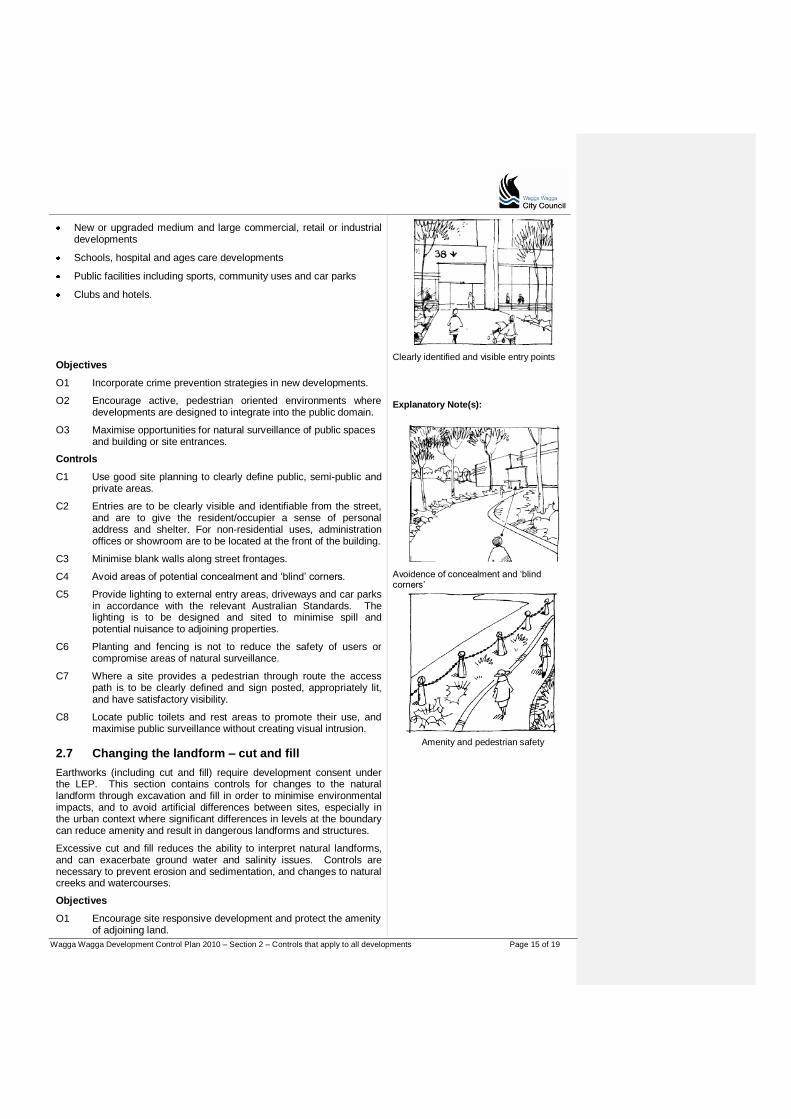
C2 Entries are to be clearly visible and identifiable from the street, and are to give the resident/occupier a sense of personal address and shelter. For non-residential uses, administration offices or showroom are to be located at the front of the building.
C3 Minimise blank walls along street frontages.
C4 Avoid areas of potential concealment and „blind‟ corners.
C5 Provide lighting to external entry areas, driveways and car parks in accordance with the relevant Australian Standards. The lighting is to be designed and sited to minimise spill and potential nuisance to adjoining properties.
C6 Planting and fencing is not to reduce the safety of users or compromise areas of natural surveillance.
C7 Where a site provides a pedestrian through route the access path is to be clearly defined and sign posted, appropriately lit, and have satisfactory visibility.
C8 Locate public toilets and rest areas to promote their use, and maximise public surveillance without creating visual intrusion.
2.7 Changing the landform – cut and fill
Earthworks (including cut and fill) require development consent under the LEP. This section contains controls for changes to the natural landform through excavation and fill in order to minimise environmental impacts, and to avoid artificial differences between sites, especially in the urban context where significant differences in levels at the boundary can reduce amenity and result in dangerous landforms and structures.
Excessive cut and fill reduces the ability to interpret natural landforms, and can exacerbate ground water and salinity issues. Controls are necessary to prevent erosion and sedimentation, and changes to natural creeks and watercourses.
Objectives
O1 Encourage site responsive development and protect the amenity of adjoining land.
Clearly identified and visible entry points
Explanatory Note(s):
Avoidence of concealment and „blind corners‟
Amenity and pedestrian safety
Wagga Wagga Development Control Plan 2010 – Section 2 – Controls that apply to all developments Page 16 of 19
O2 Avoid excessive earthworks and minimise changes to the natural landform.
O3 Encourage site layout and building design that is appropriate to the site conditions, including use of split levels, pier foundation or suspended floor house designs.
O4 Avoid adverse impacts on salinity by minimising the potential for surface water to enter the groundwater in recharge areas.
O5 Avoid inappropriate fill being introduced to sites.
O6 Ensure adequate provision for drainage in relation to cut and fill practices.
Controls
C1 Excavation is not to exceed a depth of 1.5m across the site and may only be considered at this height where there is no adverse impact on the amenity of the adjoining properties (privacy, overshadowing).
C2 Fill is not to exceed 1.5m in height across the site and may only be considered at this height where there is no impact on the amenity of the adjoining properties (privacy, overshadowing).
C3 Retaining walls are not to exceed 1.5m in height, and if greater than 500mm are encouraged to be stepped/ terraced. The distance between steps/terraces must be equal to, or exceed, the height of cut.
C4 Retaining walls and fill greater than 600mm in height are to be located at least 450mm from the property boundary. Any consideration for the location of proposed retaining wall(s) to be located within 450mm of side or rear boundaries will require the prior written approval of both landowners, submitted at the time of application in conjunction to ensuring compliance with Controls C1 and C2 within this policy.
C5 Retaining walls are not to be located within the easement. The retaining wall shall be located outside the easements zone of influence.
C6 No cut or fill to take place within easements.
C7 To encourage site responsive development, excavation and retaining walls greater than 1.5m can be considered where the design responds to the slope (or incorporates split levels). The additional retaining wall height is to facilitate basements, garages or the like at the lower level. The excavation is to be adequately retained and drained, in accordance with approved engineering details.
C8 Where achievable, any proposed dwelling is to be designed incorporating retaining walls and fill within the dwelling. Should the provision of retaining walls and fill not be achievable within a proposed dwelling due to demonstrated site constraints they should be located as close to the proposed dwelling as is possible, to minimise the impact on the amenity of the adjoining properties.
Explanatory Note(s):
C9 Retaining walls and fill are not to be located in the front setback (forward of the building line) except where a retaining wall is required to accommodate driveways, or where permissible as
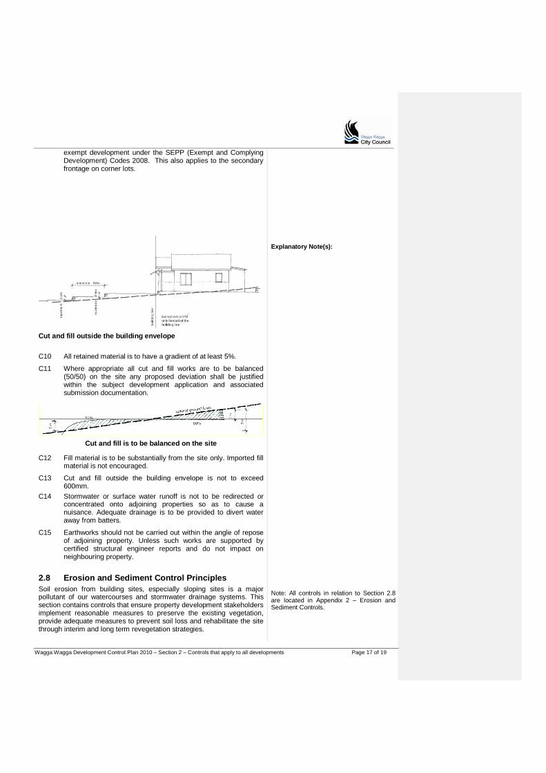
Wagga Wagga Development Control Plan 2010 – Section 2 – Controls that apply to all developments Page 17 of 19
exempt development under the SEPP (Exempt and Complying Development) Codes 2008. This also applies to the secondary frontage on corner lots.
Explanatory Note(s):
Cut and fill outside the building envelope
C10 All retained material is to have a gradient of at least 5%.
C11 Where appropriate all cut and fill works are to be balanced (50/50) on the site any proposed deviation shall be justified within the subject development application and associated submission documentation.
Cut and fill is to be balanced on the site
C12 Fill material is to be substantially from the site only. Imported fill material is not encouraged.
C13 Cut and fill outside the building envelope is not to exceed 600mm.
C14 Stormwater or surface water runoff is not to be redirected or concentrated onto adjoining properties so as to cause a nuisance. Adequate drainage is to be provided to divert water away from batters.
C15 Earthworks should not be carried out within the angle of repose of adjoining property. Unless such works are supported by certified structural engineer reports and do not impact on neighbouring property.
2.8 Erosion and Sediment Control Principles
Soil erosion from building sites, especially sloping sites is a major pollutant of our watercourses and stormwater drainage systems. This section contains controls that ensure property development stakeholders implement reasonable measures to preserve the existing vegetation, provide adequate measures to prevent soil loss and rehabilitate the site through interim and long term revegetation strategies.
Note: All controls in relation to Section 2.8 are located in Appendix 2 – Erosion and Sediment Controls.

Wagga Wagga Development Control Plan 2010 – Section 2 – Controls that apply to all developments Page 18 of 19
Objectives
O1 Protect the environment against soil erosion and loss of soil from construction sites.
O2 Prevent the degradation of drainage systems, waterways and aquatic environments from deposition of soil and foreign material from construction sites.
O3 Prevent flood damage of individual properties caused by sediment reducing the flow capacity of the stormwater drainage system.
O4 Promote the implementation of erosion and sediment control measures by persons undertaking construction and earthworks activities to prevent the loss of soil from the site.
O5 Ensure that construction works adhere to the principles of Ecologically Sustainable Development.
Explanatory Note(s):
2.9 Development adjoining open space
Objectives
O1 Ensure that developments adjoining open space contain impacts within their boundaries and don‟t impinge on, or rely on the open space area as a buffer.
O2 Encourage positive visual and physical relationships between private developments and public areas and reserves.
Controls
C1 Private developments are not to gain access across public open space.
C2 Materials are not to be stored on public land.
C3 Design, massing, scale and materials to be compatible with the amenity, views and outlook from the open space area.
C4 Landscaping is not to encroach into any public reserve.

Wagga Wagga Development Control Plan 2010 – Section 2 – Controls that apply to all developments Page 19 of 19
Wagga Wagga Development Control Plan 2010 – Section 3 – Heritage Conservation Page 1 of 18
PART B
Section 3 Heritage Conservation
Table of Contents
About Section 3 ................................................................................................................ 2 3.1 Building styles in Wagga Wagga ......................................................................... 4
3.2 Heritage items ..................................................................................................... 7 3.2.1 Alterations and additions to heritage items............................................................ 7
3.2.2 Materials, finishes and colours ............................................................................ 8 3.2.3 Adaptive reuse of heritage items ......................................................................... 8
3.2.4 Development in the vicinity of a heritage item ..................................................... 9 3.3 Wagga Wagga Heritage Conservation Area ........................................................ 9
3.3.1 Fitzmaurice commercial precinct ......................................................................... 10 3.3.2 Residential precinct ............................................................................................. 12
3.4 Community and cultural heritage ....................................................................... 17 3.5 Trees and natural heritage ................................................................................ 18

Wagga Wagga Development Control Plan 2010 – Section 3 – Heritage Conservation Page 2 of 18
About Section 3
Section 3 contains the controls for heritage conservation. Heritage items and the Wagga Wagga heritage conservation area are listed in Schedule 5 of the LEP.
Heritage items and conservation areas have special qualities that make them significant. Development needs to take particular care to ensure that the particular themes, features or characteristics that make the item or area significant are not compromised by change. This can include:
Retaining heritage items and encouraging changes to occur away from significant elements or sections of heritage items
Ensuring new work has suitable bulk, scale, proportions and detailing so that it does not dominate or compromise the ability to interpret heritage items (including adjacent or nearby items) or the heritage conservation area
Encouraging suitable materials.
Heritage items are mostly buildings but can include structures, places or relics but can include other types of items or structures. A heritage listing applies to the whole property as the heritage significance of the item is normally more than the front façade. The controls for heritage items are in Section 3.2.
A map of the Wagga Wagga Conservation Area is included in Section 3.3. The heritage conservation area includes all buildings and land within the area shown. The controls for buildings and sites within the Wagga Wagga conservation area are also in Section 3.3. Information for heritage applications Submission requirements Refer to the Guide for the submission requirements for heritage applications. Note that some applications will require a statement of heritage impact to form part of the development application. Local Heritage Grants The Council Local Heritage Assistance Fund provides support for works that will help to conserve the city’s heritage. The fund is available to support works that will conserve existing character, restore buildings or enhance the streetscape. For more information contact: Council customer service centre. Heritage Advisor Council offers a free heritage advisor service and can assist with preliminary advice on proposals affecting heritage items and sites within the Conservation Area. Contact the Council customer service centre to arrange an appointment.
All development applications received by the Council to carry out development within the Conservation Area or in relation to a heritage item will be referred to the Heritage Advisor or the Council’s heritage officer for review and advice prior to the consideration of the application.
Explanatory Note(s): Applications for works to heritage items and buildings or sites within the Conservation Area are also required to comply with other sections of the DCP. The controls for signage on heritage buildings are listed in Section 2.5 (C66-72). Complying with this DCP The controls in the DCP support the Guiding Principles and Section Objectives. A Development Application mustshould aim to satisfy the Guiding Principles, and the Objectives of the relevant sections. Equal emphasis must be given to both "numeric" and non-numeric controls relevant to a particular development. Compliance with controls will not necessarily guarantee approval of an application in the event that a proposed development has an unacceptable impact on neighbours or the surrounding environment. Where a variation is sought to controls, the application must document the reasons and extent of the variation, and how the variation meets the Guiding Principles and Section Objectives for the consideration of the Council.
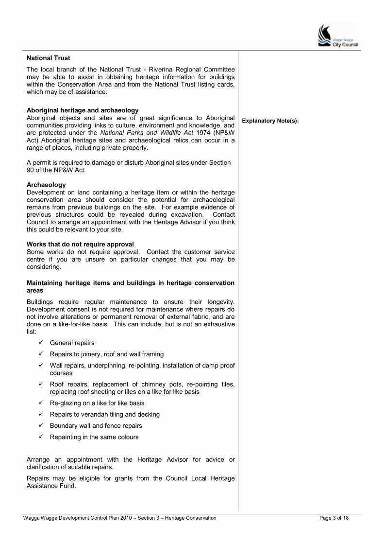
Wagga Wagga Development Control Plan 2010 – Section 3 – Heritage Conservation Page 3 of 18
National Trust
The local branch of the National Trust - Riverina Regional Committee may be able to assist in obtaining heritage information for buildings within the Conservation Area and from the National Trust listing cards, which may be of assistance.
Aboriginal heritage and archaeology Aboriginal objects and sites are of great significance to Aboriginal communities providing links to culture, environment and knowledge, and are protected under the National Parks and Wildlife Act 1974 (NP&W Act) Aboriginal heritage sites and archaeological relics can occur in a range of places, including private property. A permit is required to damage or disturb Aboriginal sites under Section 90 of the NP&W Act. Archaeology Development on land containing a heritage item or within the heritage conservation area should consider the potential for archaeological remains from previous buildings on the site. For example evidence of previous structures could be revealed during excavation. Contact Council to arrange an appointment with the Heritage Advisor if you think this could be relevant to your site. Works that do not require approval Some works do not require approval. Contact the customer service centre if you are unsure on particular changes that you may be considering.
Maintaining heritage items and buildings in heritage conservation areas
Buildings require regular maintenance to ensure their longevity. Development consent is not required for maintenance where repairs do not involve alterations or permanent removal of external fabric, and are done on a like-for-like basis. This can include, but is not an exhaustive list:
General repairs
Repairs to joinery, roof and wall framing
Wall repairs, underpinning, re-pointing, installation of damp proof courses
Roof repairs, replacement of chimney pots, re-pointing tiles, replacing roof sheeting or tiles on a like for like basis
Re-glazing on a like for like basis
Repairs to verandah tiling and decking
Boundary wall and fence repairs
Repainting in the same colours
Arrange an appointment with the Heritage Advisor for advice or clarification of suitable repairs.
Repairs may be eligible for grants from the Council Local Heritage Assistance Fund.
Explanatory Note(s):

Wagga Wagga Development Control Plan 2010 – Section 3 – Heritage Conservation Page 4 of 18
Colour schemes Colour choice is often based on fashion, and can change over time. Original colour schemes usually reflect the period of the property. Use of traditional colours can enhance the contribution of a property to the conservation area. Many paint suppliers have traditional colour charts that indicate suitable colours for properties from various periods. Publications are also available that demonstrate the use of these colours. References on heritage colour schemes include:
Evans, Ian, Lucas, Clive and Ian Stapleton, Colour Schemes for Old Australian Houses, Flannel Flower Press
Evans, Ian, Lucas, Clive and Ian Stapleton, More Colour Schemes for Old Australian Houses, Flannel Flower Press
Wagga Wagga Urban and Rural Heritage Studies
Fitzmaurice Street Precinct Study
Evans, Ian, Caring for Old Houses
Stapleton, Ian, How to restore the old Aussie House
Civic Trust, Which fence for my house?
Department of Planning, Getting the details right
Department of Planning, New uses for heritage places
Department of Planning, Design in context The Council Heritage Advisor is available to provide advice on colour schemes. Development consent is required for repainting where the colour scheme is to be changed.
3.1 Building styles in Wagga Wagga
VICTORIAN PERIOD (to c1890)
Vernacular cottage
Explanatory Note(s): Refer to the Guide for all requirements for development applications for works to heritage items or within the Heritage Conservation Area. Characteristic features Single fronted form, symmetrical massing Gable roof, open front verandah with little decoration Simple brick chimney Skillion lean-to” to the rear Timber louvred shutters to windows Materials Face brick with corrugated iron roofing Brick rendered window sill Timber verandah and brick steps
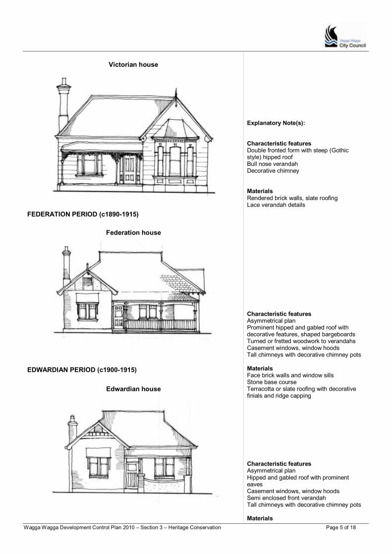
Wagga Wagga Development Control Plan 2010 – Section 3 – Heritage Conservation Page 5 of 18
Victorian house
FEDERATION PERIOD (c1890-1915)
Federation house
EDWARDIAN PERIOD (c1900-1915)
Edwardian house
Explanatory Note(s): Characteristic features Double fronted form with steep (Gothic style) hipped roof Bull nose verandah Decorative chimney Materials Rendered brick walls, slate roofing Lace verandah details Characteristic features Asymmetrical plan Prominent hipped and gabled roof with decorative features, shaped bargeboards Turned or fretted woodwork to verandahs Casement windows, window hoods Tall chimneys with decorative chimney pots Materials Face brick walls and window sills Stone base course Terracotta or slate roofing with decorative finials and ridge capping
Characteristic features Asymmetrical plan Hipped and gabled roof with prominent eaves Casement windows, window hoods Semi enclosed front verandah Tall chimneys with decorative chimney pots Materials
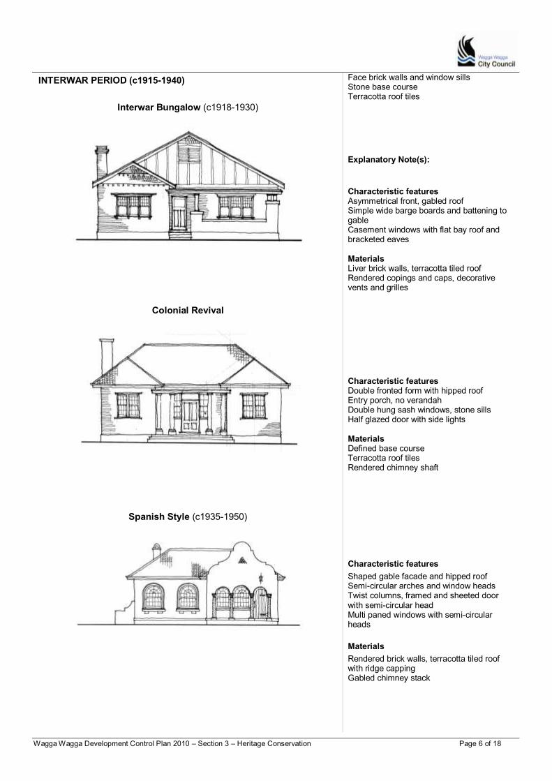
Wagga Wagga Development Control Plan 2010 – Section 3 – Heritage Conservation Page 6 of 18
INTERWAR PERIOD (c1915-1940)
Interwar Bungalow (c1918-1930)
Colonial Revival
Spanish Style (c1935-1950)
Face brick walls and window sills Stone base course Terracotta roof tiles
Explanatory Note(s):
Characteristic features Asymmetrical front, gabled roof Simple wide barge boards and battening to gable Casement windows with flat bay roof and bracketed eaves Materials Liver brick walls, terracotta tiled roof Rendered copings and caps, decorative vents and grilles
Characteristic features Double fronted form with hipped roof Entry porch, no verandah Double hung sash windows, stone sills Half glazed door with side lights Materials Defined base course Terracotta roof tiles Rendered chimney shaft
Characteristic features
Shaped gable facade and hipped roof Semi-circular arches and window heads Twist columns, framed and sheeted door with semi-circular head Multi paned windows with semi-circular heads
Materials
Rendered brick walls, terracotta tiled roof with ridge capping Gabled chimney stack
Wagga Wagga Development Control Plan 2010 – Section 3 – Heritage Conservation Page 7 of 18
3.2 Heritage items
Heritage items are listed in Schedule 5 of the LEP. Heritage items can be buildings, works, trees, places, archaeological relics or Aboriginal objects. All heritage items are recognised for their particular value or heritage significance.
Maintaining heritage items is the most practical way to protect the significance and history of a building, work, relic or place. Common maintenance tasks are:
1. Ensure roofs are secure and without gaps or broken tiles that will allow water penetration.
2. Keep trees and branches pruned and clear of roofs and walls.
3. Ensure roof and site drainage systems are operating efficiently, check condition of gutters, drainpipes and drains regularly and keep clear of debris.
4. Regular monitoring of walls and cladding for structural soundness and protection from water, wind, dust and vermin.
5. Weed and prune plants, and repair significant garden structures.
6. Regularly check and repair broken fencing.
7. Maintain adequate under floor ventilation.
Demolition of heritage items is generally not supported. Contact the Council to arrange a meeting with the Heritage Advisor if you are considering demolition of a heritage item.
3.2.1 Alterations and additions to heritage items
Objectives
O1 Protect heritage significance by minimising impacts on the significant elements of heritage items.
O2 Encourage alterations and additions which are sympathetic to the building’s significant features and which will not compromise heritage significance.
O3 Ensure that alterations and additions respect the scale, form and massing of the existing building.
Controls
C1 Avoid changes to the front elevation - locate new work to the rear of, or behind the original building section.
C2 Design new work to respect the scale, form, massing and style of the existing building, and not visually dominate the original building.
C3 The original roof line or characteristic roof elements are to remain identifiable and not be dwarfed by the new works.
C4 Retain chimneys and significant roof elements such as gables and finials where present.
C5 Ensure that the new work is recognisable as new, “blending in” with the original building without unnecessarily mimicking or copying.
Explanatory Note(s):
Refer to Section 3.3.2 for relevant controls regarding alterations and additions to residential heritage items.

Wagga Wagga Development Control Plan 2010 – Section 3 – Heritage Conservation Page 8 of 18
C6 Complement the details and materials of the original roof including ridge height and slopes without compromising the ability to interpret the original form.
C7 New materials are to be compatible with the existing finishes. Materials can differentiate new work from original building sections where appropriate, for example by the use of weatherboards where the original building is brick or by the use of “transitional” materials between old and new.
C8 Retain front verandahs. Reinstating verandahs, and removing intrusive changes is encouraged, particularly where there is physical and/ or historic evidence.
3.2.2 Materials, finishes and colours
Objectives
O1 Encourage materials, finishes and colours that are suitable to the period of the building.
Controls
C1 Select materials to be compatible, but not necessarily matching the materials of the building. The materials should complement the period and style of the heritage item.
C2 Colour schemes are to reflect the period and detail of the property.
C3 Painting or rendering face brick is generally not supported.
3.2.3 Adaptive reuse of heritage items
Adaptive reuse of heritage buildings can provide the necessary viability for the continued use and maintenance of heritage buildings. Accommodating the new use should involve minimal change to significant fabric in order to protect heritage significance.
Elements or artefacts from the original use (where present) may be required to be retained to assist interpretation. For example, retaining machinery institute and the like.
Objectives
O1 Encourage heritage items to be used for purposes appropriate to their heritage significance.
Controls
C1 The adaptive reuse of a heritage item should minimise alterations or interference with significant fabric. The changes are to enable the continued interpretation of the original use.
C2 Ensure that new services are sympathetically installed especially where upgrading is required to satisfy fire or BCA requirements.
Explanatory Note(s):
Wagga Wagga Development Control Plan 2010 – Section 3 – Heritage Conservation Page 9 of 18
3.2.4 Development in the vicinity of a heritage item
Development in the vicinity of a heritage item can have an impact upon the heritage significance of the item, in particular through an impact its setting. Determining whether a property is within the setting of a heritage item is a necessary component of the site analysis for proposal. Advice from Council’s heritage advisor may be required to determine this. The analysis should consider historical property boundaries, significant vegetation and landscaping, archeologically features and significant views.
Objectives
O1 Encourage development in the vicinity of a heritage item to be designed and sited to protect the significance of the heritage item.
Explanatory Note(s):
Controls
The adaptive reuse of a heritage item is to minimise alterations or interference
C1 Alterations and additions to the buildings and structure, and new development are to be designed to respect and compliment the heritage item in terms of building envelope, proportions, materials, colours, finishes and building street alignment.
C2 Development in the vicinity of a heritage item is to minimise the impact on the setting of the item by:
a) Providing an adequate area around the heritage item to allow its interpretation.
b) Retaining original or significant landscaping associated with the heritage item.
c) Protecting and allowing the interpretation of archaeological features associated with the heritage item.
d) Retaining and respecting significant views to and from the heritage item.
3.3 Wagga Wagga Heritage Conservation Area
About the Wagga Wagga Heritage Conservation Area
The heritage conservation area incorporates the area of the town’s early settlement. The heritage conservation area includes the Fitzmaurice Street commercial precinct and the residential precincts to the west and south.
The conservation area has cohesive streetscape qualities. Characteristic elements that contribute to the conservation area’s thematic significance and character are:
Buildings from the Victorian, Federation, Edwardian and Interwar periods
Single storey dwellings, mainly detached dwellings
Pitched roofs and similar roof styles
Common use of local red brick with corrugated iron roofing
Common fencing styles and materials
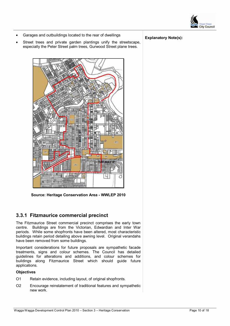
Wagga Wagga Development Control Plan 2010 – Section 3 – Heritage Conservation Page 10 of 18
Garages and outbuildings located to the rear of dwellings
Street trees and private garden plantings unify the streetscape, especially the Peter Street palm trees, Gurwood Street plane trees.
Source: Heritage Conservation Area - WWLEP 2010
Explanatory Note(s):
3.3.1 Fitzmaurice commercial precinct
The Fitzmaurice Street commercial precinct comprises the early town centre. Buildings are from the Victorian, Edwardian and Inter War periods. While some shopfronts have been altered, most characteristic buildings retain period detailing above awning level. Original verandahs have been removed from some buildings.
Important considerations for future proposals are sympathetic facade treatments, signs and colour schemes. The Council has detailed guidelines for alterations and additions, and colour schemes for buildings along Fitzmaurice Street which should guide future applications.
Objectives
O1 Retain evidence, including layout, of original shopfronts.
O2 Encourage reinstatement of traditional features and sympathetic new work.
Wagga Wagga Development Control Plan 2010 – Section 3 – Heritage Conservation Page 11 of 18
O3 Encourage reinstatement of front verandahs and awnings based on historic information (drawings, photographs) and/ or interpretation of period details.
O4 Encourage use of traditional colour schemes based on the period of the building.
O5 Encourage signs that complement, rather than dominate, the architectural characteristics of the building.
O6 Discourage proliferation of signs on buildings.
O7 Encourage infill development or the replacement of uncharacteristic buildings to reflect the historic character of the precinct and nearby characteristic buildings.
O8 Encourage the service elements (solar panels, solar heating, antennas, satellite dishes and air conditioning units) to be placed to the rear of the properties, preferably not visible from the street.
Explanatory Note(s):
Controls
Facade treatment
C1 Retain original elements and features, including features that are above awning level.
C2 Where original shopfronts, verandahs or awnings have been altered, the replacement is to be based on historic information and/or the interpretation of period details.
C3 Infilling original verandahs is not supported.
C4 Additional storeys can be considered if set well behind the front building line and designed to not impact detrimentally on the contribution of the original facade to the streetscape. Service elements (solar panels, solar heating, antennas, satellite dishes and air conditioning units) to be placed to the rear of the properties, preferably not visible from the street, or on rear outbuildings.
C5 Rendering or painting face brick is generally not supported.
Infill development
C1 Design infill and replacement buildings to reflect the general historic character of the precinct and nearby characteristic and heritage buildings.
C2 Maintain a two storey building height at the street frontage, constructed with a nil setback.
C3 Where sites are amalgamated use articulation to reflect the former subdivision pattern.
C4 Maintain a balance of solid area over void. Large areas of plate glass curtain walls are generally not suitable and will not be supported.
C5 Use awnings and verandahs to reduce the bulk and scale of buildings.
C6 Use of articulation in facades such as string courses, cornices, pilasters and other features that break up the scale of facades is encouraged.

Wagga Wagga Development Control Plan 2010 – Section 3 – Heritage Conservation Page 12 of 18
C7 Painting of facades in corporate colours is not supported and corporate identity should be established through appropriate signage.
Explanatory Note(s):
Colour schemes
The controls aim to encourage use of colours in a traditional way with base colours and highlights to appropriate elements. It is not intended to demand strict adherence to prescribed colours. External redecoration may be eligible for a grant from the Council Local Heritage Assistance Fund, if carried out using traditional colours.
C1 Colour schemes are to reflect the period and detail of the building, particularly where a building is identified as a streetscape reference building or contributes to the character of the conservation area.
3.3.2 Residential precinct
Characteristic buildings and elements are integral to the cohesive character of the conservation area’s residential precincts. Characteristic building date from the main building periods and styles represented in Wagga Wagga as illustrated in Section 3.1. They should generally be retained and are important references for new work and infill development.
Some development has occurred in the conservation area that does not reflect the characteristic built form and is intrusive to the area’s character. Examples of uncharacteristic elements include:
Single and multi storey apartment buildings
Infill commercial development or development that is non-residential in character in the residential precincts
Extensive car parking areas
Removal of significant elements such as front verandahs.
Consideration can be given to demolishing or upgrading uncharacteristic elements provided it can be shown that the new development is sympathetic to the conservation area.
Alterations, additions and infill development
Objectives
O1 Retain characteristic buildings from significant periods of development for the conservation area.
O2 Retain details and features that are characteristic of the conservation area, and encourage reinstatement of these features where they have been removed.
O3 Encourage new buildings to respond positively to the character of adjoining and nearby buildings.
O4 Ensure that new work is sympathetic to the bulk, mass and scale of characteristic buildings in the conservation area.
Wagga Wagga Development Control Plan 2010 – Section 3 – Heritage Conservation Page 13 of 18
Controls
Retain characteristic buildings and features
C1 Characteristic buildings are to be retained. Demolition will not be considered unless the applicant can demonstrate that the building or structure is not a characteristic building, is of little heritage significance or is structurally unsound or beyond repair.
C2 Original features and materials of characteristic buildings are to be retained. Reinstating features that have been removed is encouraged. This includes verandahs, decorative joinery, doors, windows and leadlights. The use of cladding (vinyl, metal, over timber weatherboards and brick work is not supported)
C3 Changes that remove or obscure characteristic features are not supported. This includes enclosing open verandahs, removing decorative features, replacing timber windows and doors with aluminium or other materials, rendering or painting face brick and removing chimneys that are visible from the street.
C4 Rendering or painting face brick is generally not supported.
Explanatory Note(s):
Timber buildings are easily repaired by replacing weatherboards and the timber structure.
The Local Heritage Assistance Fund can provide financial assistance for reinstatement of characteristic elements and features.
Applications for demolition must be accompanied by a Heritage Impact Statement prepared by a suitably qualified consultant and structural of building surveyors report identifying in detail the condition of building and any required repairs.
Alterations and additions
C1 Design new work to complement the style and period of the building in terms of style, scale, form, roof form and materials. New works can be a modern interpretation and do not need to strictly follow the original style.
C2 Alterations should generally be to the rear of the property. Alterations to the side can be considered where side setbacks are sufficient.
C3 Additions are to retain, and be subservient in form and scale, to the primary form of the building.
C4 New work is to be below the main ridge height of the building, and be articulated from the primary form by setbacks in the walls and height of the roof. Maintain a descending scale to the rear.
C5 Use vertically proportioned windows.
C6 Select materials to complement the period and style of the building and the conservation area. Use compatible, but not necessarily matching materials – modern materials may be appropriate.
Alterations and additions are also required to satisfy the requirements of Section 9 of the DCP.
Two storey and roof additions
C1 Two storey additions are generally not appropriate in the conservation area unless there is a fall of the site to the rear. Where they can be considered, the addition is to be set behind the principal building form and be lower than the ridge height of the principal roof. The addition is not to extend across the full width of the building form.
C2 Roof and attic additions can be considered where there are no dormers to the front or side elevations and the works do not require removal or lowering of ceilings in the front rooms of the principal building form.
Wagga Wagga Development Control Plan 2010 – Section 3 – Heritage Conservation Page 14 of 18
Infill development
C3 Infill development is to reflect the characteristic buildings in the vicinity in terms of bulk, scale, roof form, setbacks and materials.
C4 Setbacks are to reflect the patterns of adjoining houses and the general pattern of the street.
C5 Use pitched roofs with slate, terracotta tiles or corrugated metal.
C6 Contemporary design is acceptable where it is sympathetic to the characteristic built form of the conservation area, particularly in terms of bulk, scale, height, form or materials.
C7 Designs that open front verandahs are encouraged.
C8 Use a variety of wall materials to break up the mass of the building and provide detail to the front elevations.
Explanatory Note(s):
Colour schemes
The controls aim to encourage use of colours in a traditional way with base colours and highlights to appropriate elements. It is not intended to demand strict adherence to prescribed colours. External redecoration may be eligible for a grant from the Council Local Heritage Assistance Fund, if carried out using traditional colours.
Objectives
O1 Encourage appropriate colour schemes suitable to the period of the property.
Controls
C1 Colour schemes are to reflect the period and detail of the property.
C2 Painting face brick is not supported.
Secondary dwellings on rear lanes
The rear lanes of the conservation area are becoming increasingly active, with a range of developments and building forms. Secondary dwellings and loft type accommodation, often constructed over a garage, can be considered on rear lanes where there is sufficient site width and area.
Secondary dwellings and buildings containing habitable space are also required to comply with the controls for residential development at Section 9 of the DCP.
Objectives
O1 Ensure secondary dwellings and similar structures are located on sites with adequate area and width.
O2 Avoid inappropriately bulky and visually intrusive structures on rear lanes.
O3 Maintain adequate sight lines and ensure the ongoing safety and functionality of rear lanes.
Wagga Wagga Development Control Plan 2010 – Section 3 – Heritage Conservation Page 15 of 18
Controls
C1 Minimum frontage/site width – 9m.
C2 Any residential or habitable accommodation is to be above the footprint of the ground floor garage.
C3 The residential or habitable accommodation is to be in the form of a loft addition set into the roof space.
C4 Maximum wall height to eave - 4.2m.
C5 The upper section is to be constructed using contrasting materials in order to lower the apparent height and reduce apparent bulk and scale.
C6 Roof forms and elements such as dormers that articulate and break up the roof are encouraged.
Explanatory Note(s):
Refer to Section 9 for residential development controls.
Garages and carports
The absence of garages and carports in the streetscape is an important characteristic of the conservation area. A number of the streets have rear lanes, and where the property is adequate, consideration can be given to a double garage/ carport on the rear lane.
Objectives
O1 Minimise visual intrusion from garages and carports, and require structures to be located behind the building line.
O2 Establish parameters for the proportion and detailing of garage and carports.
Controls
C1 Where possible, car access should be from a rear lane.
C2 Where no rear lane access is available locate the garage or carport behind the building line, or preferably to the rear of the property. Alterations that require removal of original features on a front elevation or require demolition of significant building fabric to enable car access will not be supported.
C3 Materials are to be compatible with the materials of the main building. Any detailing is to be subservient to the detailing or decorative features of the main building.
C4 Max size of garages:
Single garage – 3000mm wide x 7500mm long, 2400mm walls, 27 degree roof pitch rising to an apex 3400mm high. Garage roller door 2600mm wide.
Double garage – 6000mm wide x 7500mm long, 2400mm walls, 27 degree roof pitch rising to apex 3900mm high. Two roller doors 2600mm wide in 3 equal wall bays.
Roof pitch 27 degrees (quarter pitch) or steeper to match the roof pitch of the house. Roof pitches can be broken with a 10 to 12.5 degree pitch verandah skillion.
C5 Specifications:
Walls can be in Custom Orb corrugated metal, weatherboards, fibre cement sheet or face brick
Galvanised corrugated metal roof preferred rather than Zincalume.
Roll barge and roll top.
Wagga Wagga Development Control Plan 2010 – Section 3 – Heritage Conservation Page 16 of 18
Gutters are to be quad or ogee profile and galvanised.
C6 Doors may be tilt doors of a simple design and neutral colour. Roller doors may be considered on merit.
Explanatory Note(s):
Carports
C7 Where a carport is to be constructed to the side of a house:
Single car – setback at least 1m from the principal building line or level with the back of the front verandah.
Use a skillion or flat roof form in corrugated metal with the high point set below the eave of the principal building form.
Length is to be no more than half the length of the side of the building to which it is attached.
C8 Double carports can be considered on rear lanes.
Gardens
Private gardens play an important role in the character of the conservation area by reinforcing street plantings and the local parks.
Garden layouts and plantings often relate to the period of the house, and planting gardens that reinforce the period and character of the house is encouraged. However, Wagga Wagga’s climate is not always compatible with the needs of exotic plant varieties, particularly where they require regular watering. Planting schemes can include native plants to achieve the same effect as a traditional garden.
Objectives
O1 Encourage traditional garden layout and planting schemes.
O2 Retain original paths and garden structures.
O3 Discourage construction of uncharacteristic structures in front gardens.
The National Trust’s Inter-war Gardens Guide is a useful source on traditional garden layouts
Controls
C1 Retain original paths and garden layouts.
C2 Use traditional planting schemes – consider use of native species to achieve a traditional effect.
C3 Retain significant trees. Fences
Fences play an important role in the streetscape of the conservation area, including the streetscape of rear lanes. Fences should relate to the period of the house. The guide Which Fence for My House (Wagga Wagga Civic Trust, Active Print, 2000) is available for owners, and demonstrates fence styles that are suitable for houses from different periods. Contact the Council Heritage Advisor, for further advice.
Wagga Wagga Development Control Plan 2010 – Section 3 – Heritage Conservation Page 17 of 18
Objectives
O1 Retain original front fences.
O2 Limit the height of side and rear fences, particularly where they are visible from the street or rear lane.
O3 Encourage replacement of unsympathetic fencing with more appropriate fences that are related to the period and style of the property.
O4 Encourage use of sympathetic materials for side and rear fences, and discourage use of colorbond panelling.
Explanatory Note(s):
Controls
C1 Retain original front fences, or, if in need of repair, replace on a like for like basis.
C2 Front fences to be a maximum height of 1.2m.
C3 Side fences that are visible from the street are to be constructed in timber or corrugated metal.
C4 The side fence is to slope down to a maximum height of 1.2m at the front main building line.
C5 Side and rear fences greater than 1.8m in height will not generally be supported.
3.4 Community and cultural heritage
Wagga Wagga has a number of heritage items that either public buildings, or which are located in the public domain, including many in the conservation area. Civic buildings, war memorials, churches, schools and community halls are often heritage items that are also landmarks within the local area.
Objectives
O1 Protect the heritage significance of public and community buildings.
O2 Allow for ongoing use of community and public buildings for the purpose for which they were constructed.
Controls
C1 Retain features or elements that are intrinsic to the heritage significance of the heritage item and its setting.
C2 Respect the scale and detail of the original (or significant) building in the design and siting of new work.
C3 Design and locate new work to minimise impacts on the setting of the heritage item, particularly where new buildings, structures or landscaping are proposed.
C4 Work related to servicing, fire safety or BCA compliance is to minimise interference with significant fabric and features.
Wagga Wagga Development Control Plan 2010 – Section 3 – Heritage Conservation Page 18 of 18
3.5 Trees and natural heritage
Wagga Wagga’s natural heritage includes remnant native trees along the Murrumbidgee River, trees associated with heritage items, and street plantings such as the palm trees along Peter Street, and parks such as Collins Park and the former Botanic Gardens.
The character of the Heritage Conservation Area is also reinforced by natural elements in the public domain. This includes wide streets, narrow rear lanes, street plantings, nature strips and parks.
Removing significant trees is generally not supported unless there is evidence that the tree is diseased, dying or dangerous.
Explanatory Note(s): Removing trees is generally not supported unless there is evidence that the tree is diseased, dying or dangerous. Refer to Section 5.2 of the DCP for Preservation of Tree controls.
Objectives
O1 Recognise the importance of natural heritage items, including remnant native tree groups.
O2 Minimise impacts on natural heritage items by sensitive location of building and construction works.
O3 Support the ongoing protection, care and management of natural heritage items.
Controls
C1 Locate site works, including driveways, away from trees and other natural heritage items.
C2 Works to natural heritage items are to be considered in terms of the likely affect on the significance of the item, integrity and intactness, and condition/health.
C3 For large street trees, and trees in the road reserve, minimise impacts on significant specimens within the group, and the effect on connectivity with adjoining or nearby remnant groups.
Wagga Wagga Development Control Plan 2010 – Section 7 - Subdivision Page 1 of 9
PART D
Section 7 Subdivision
Table of Contents About Section 7 ............................................................................................................... 2
7.1 Rural subdivision ..................................................................................... 3 7.2 Residential and large lot residential subdivision ...................................... 3
7.2.1 Topography, views and setting ................................................................ 3 7.2.2 Design for use and accessibility .............................................................. 4
7.2.3 Solar access, energy efficiency, size and shape of lots........................... 5 7.2.4 Open space, parks and the public domain ............................................ 76
7.2.5 Water Sensitive Urban Design .............................................................. 87 7.2.6 Services ................................................................................................. 87
7.3 Industrial Subdivisions ........................................................................... 98
Wagga Wagga Development Control Plan 2010 – Section 7 - Subdivision Page 2 of 9
About Section 7
Section 7 contains the controls for the subdivision of land. The controls of this section do not apply to the release areas that are subject to Part E of the DCP, or to land within the following areas where the controls as listed from Wagga Wagga Development Control Plan 2005 (the DCP 2005), continue to apply:
Neighbourhood area DCP 2005 Chapter
Mitchell Road Chapter 30
South Tatton Chapter 31
Bakers Lane Chapter 36
Bourkelands Chapter 38
Hill Top Chapter 39
Boorooma Chapter 41
Forest Hill Chapter 42
Estella Chapter 44
Where there is an inconsistency between the LEP and the DCP 2005 Chapters, the LEP shall prevail.
The LEP sets minimum lot sizes for rural, rural small holdings and large lot residential land, and specifies the residual development potential of certain sites. Where no minimum lot size applies proposals for subdivision will be assessed on their merits against the Guiding Principles of the DCP, the subdivision design principles set out below, and the Objectives and Controls of this section.
The core concepts for the merit assessment of subdivision proposals are reflected in the basic design principles set out below. These are:
Achieving site and environmentally responsive subdivision
Ensuring that the size, shape and environmental characteristics of future lots will support appropriate development and maximise the potential for reasonable solar access to future dwellings
Achieving good public domain outcomes.
Explanatory Note(s): Complying with this DCP The controls in the DCP support the Guiding Principles and Section Objectives. A Development Application mustshould aim to satisfy the Guiding Principles, and the Objectives of the relevant sections. Equal emphasis must be given to both "numeric" and non-numeric controls relevant to a particular development. Compliance with controls will not necessarily guarantee approval of an application in the event that a proposed development has an unacceptable impact on neighbours or surrounding environment. Where a variation is sought to controls, the application must document the reasons and extent of the variation, and how the variation meets the Guiding Principles and Section Objectives for the consideration of the Council. Refer to appendix 5 for relevant provisions of the Wagga Wagga Development Control Plan 2005 A development application to subdivide should be accompanied by written confirmation or otherwise for an Aboriginal Cultural Heritage Assessment. This may assessment may already have been undertaken at the “masterplanning” stage.
Subdivision design principles
P1 Subdivision design should provide a foundation for good urban form in terms of environmental responsiveness, legibility, accessibility and the ability to support quality development.
P2 Subdivision design should be responsive to orientation, topography, natural features, catchments, and the established subdivision pattern.
P3 The size and shape of lots must be able to support sustainable development. Lot sizes may need to be increased where there are unusual physical, visual or environmental constraints. For example lots on steeper sites may need to be larger to provide flexibility for siting future buildings.
P4 Subdivision for residential development should be able to comply with the land area per dwelling requirements contained in Section 9.
Subdivision in bushfire prone areas is subject to particular requirements under Planning for Bushfire Protection. Refer to Section 4.1 of Part B for relevant controls. Note some applications are required to be referred to the NSW Rural Fire Service. Subdivision in flood prone areas is subject to particular requirements and restrictions. Refer to Section 4.2 of Part B for relevant controls
Formatted: No bullets or numbering

Wagga Wagga Development Control Plan 2010 – Section 7 - Subdivision Page 3 of 9
7.1 Rural subdivision
This section applies to land in the RU1 and the RU2 Zones in the LEP. For subdivision requirements in relation to the RU5 Village zone refer to Section 6 of this DCP. Objectives
O1 Protect the landscape character of rural areas of the Wagga Wagga local government area.
O2 Encourage best practice farm management and allow for some flexibility for adaptation in the rural sector.
O3 Avoid conflicts between land uses. Controls
C1 Lots in the RU1 and the RU2 Zones are to have all weather two wheel drive access to a public road using existing access points where possible.
C2 Reflect existing fence lines and/or natural features (as appropriate).
C3 A building envelope is to be nominated where a dwelling is to be constructed. The envelope is to satisfy the requirements at Section 8.1 of the DCP and provide satisfactory setbacks to creek lines, minimise cut and fill and visual interference to rural landscapes.
C4 Minor boundary adjustments that reinforce the subdivision design principles and facilitate the economic and efficient use of land are generally supported.
C5 Farm adjustments that consolidate land locked sites and achieve access to a public road are generally supported.
C6 For the purposes of Clause 2.6(2)(b) of the LEP a “minor realignment” means a change to one property boundary that is minor in nature and does not create any new dwelling rights (or alter existing rights) or alter compliance with any minimum lot size established by the LEP.
Explanatory Note(s): The SEPP (Rural Lands) 2008 establishes principles, objectives and assessment requirements for subdivision of rural land. The SEPP can be viewed at www.legislation.nsw.gov.au. The Roads and Traffic Authority (RTAMaritime Services (RMS) approval is required for any new access point to a main road. Issues for consideration are safety and site stopping distances. Dual use of existing entries is generally preferred.
7.2 Residential and large lot residential subdivision
This section contains the controls for residential subdivision, including rural residential/ large lot residential developments. The section applies to all land in the RU4, R1, R3 and R5 Zones.
Any building that is proposed for strata subdivision is required to comply with relevant fire safety provisions. Council may require associated fire upgrading works as part of an application for strata subdivision.
Depending on the environmental conditions specialist studies may be required to address Salinity Sensitive Urban Design (SSUD), tree cover and native vegetation and other similar issues.
Section 9 contains requirements for “land area per dwelling”. Specialist studies may already have been undertaken at the “masterplanning” stage.
7.2.1 Topography, views and setting
The natural landform and setting contribute to a sense of place.
Subdivision should be responsive to the setting and natural site features, and established subdivision patterns.
Wagga Wagga Development Control Plan 2010 – Section 7 - Subdivision Page 4 of 9
Pre-determined subdivisions are generally not supported as they fail to consider particular characteristics of location.
Objectives
O1 Encourage site specific solutions and site responsive development.
O2 Discourage predetermined layouts that may not suit local topography, subdivision pattern and the like.
O3 Design to maximise the natural features of the land. Controls
C1 Avoid street layouts that result in lots being considerably higher or lower than the street level.
C1C2 New roads are to respond to topographical features. Where land slopes at a grade of 610 percent or more the predominant street alignment should be perpendicular to contours. In other cases streets should be parallel to the contours..
C2C3 Maintain existing mature trees where possible or provide a reasonable strategy for replanting mature specimens in the subdivision.
C4 Subdivisions are to be designed such that lots intended for residential development shall have a “street address” to an existing or proposed public road. That is, subdivision is to avoid the creation of allotments, the rear of which “front” or “address” a public road resulting in the erection of rear fences along public road boundaries.
Explanatory Note(s):
A landscape design may be required to integrate with water sensitive urban design systems for the subdivision.
Controls on changes to the natural landform, including cut and fill are included in Section 2.7 of the DCP.
7.2.2 Design for use and accessibility
Good subdivision offers connectivity and has a legible hierarchy of streets and through routes. Roads should offer a choice of routes for pedestrian and vehicles, and integrate to adjoining streets, neighbourhoods and local facilities or shops with minimal use of dead-end and cul-de-sac roads.
Objectives
O1 Ensure a logical street hierarchy and logical services design.
O2 Design streets to respond to their role and function and ensure good connections to adjoining neighbourhoods.
O3 Ensure access and facilities for pedestrians and cyclists.
Controls
C1 Neighbourhood road networks are to maximise connectivity within the development, and to the existing street network and adjoining neighbourhoods. Avoid long roads with few connecting side streets that reduce the ability to readily access the area.
C2 Footpaths or shared paths may be required for pedestrians and cyclists, to link local facilities, services and open space areas, especially where identified in any access strategy.
Footpaths are generally required on both sides of the street in the case of collector roads.
Wagga Wagga Development Control Plan 2010 – Section 7 - Subdivision Page 5 of 9
C3 Minimum dimensions for footpaths:
Generally - at least 1.5m in width (unless there are only a small number of houses where footpaths can be reduced to 1.2m)
Shared paths - at least 2.5m in width
C4 Avoid cul-de-sac roads in locations where the dead end would limit links through the neighbourhood, and where more than 10 houses are likely to have access from the cul-de-sac.
Note: Refer to Council‟s Engineering Guidelines for Subdivision and Developments for detailed design requirements.
Explanatory Note(s):
7.2.3 Solar access, energy efficiency, size and shape of lots
Subdivision design can influence the ability of future development to achieve good solar access. The controls of this section aim to link the orientation of lots to the preferred location of future buildings in order to maximise solar access and liveability of dwellings constructed on the lots.
The orientation of roads is also an important factor influencing an energy efficient subdivision. Roads having an alignment east-west facilitate good orientation for solar access to dwellings and private open space, especially where the lots have a narrow lot frontage and longer length. Lots on roads running north-south typically need to be wider and shorter. Objectives
O1 Encourage development that delivers good outcomes for orientation and solar efficiency.
O2 Ensure that lots are appropriate for development considering the scale, character and form of existing housing in the locality and environmental conditions and constraints including topography.
O2O3 Ensure residential subdivisions allow sufficient area for private open space, landscaping and amenity for future residents.
Controls
C1 In any subdivision aAt least 70 percent of the total number of lots should have their long axis oriented within 45 degrees of north so that the long axis of each dwelling is generally oriented east-west.
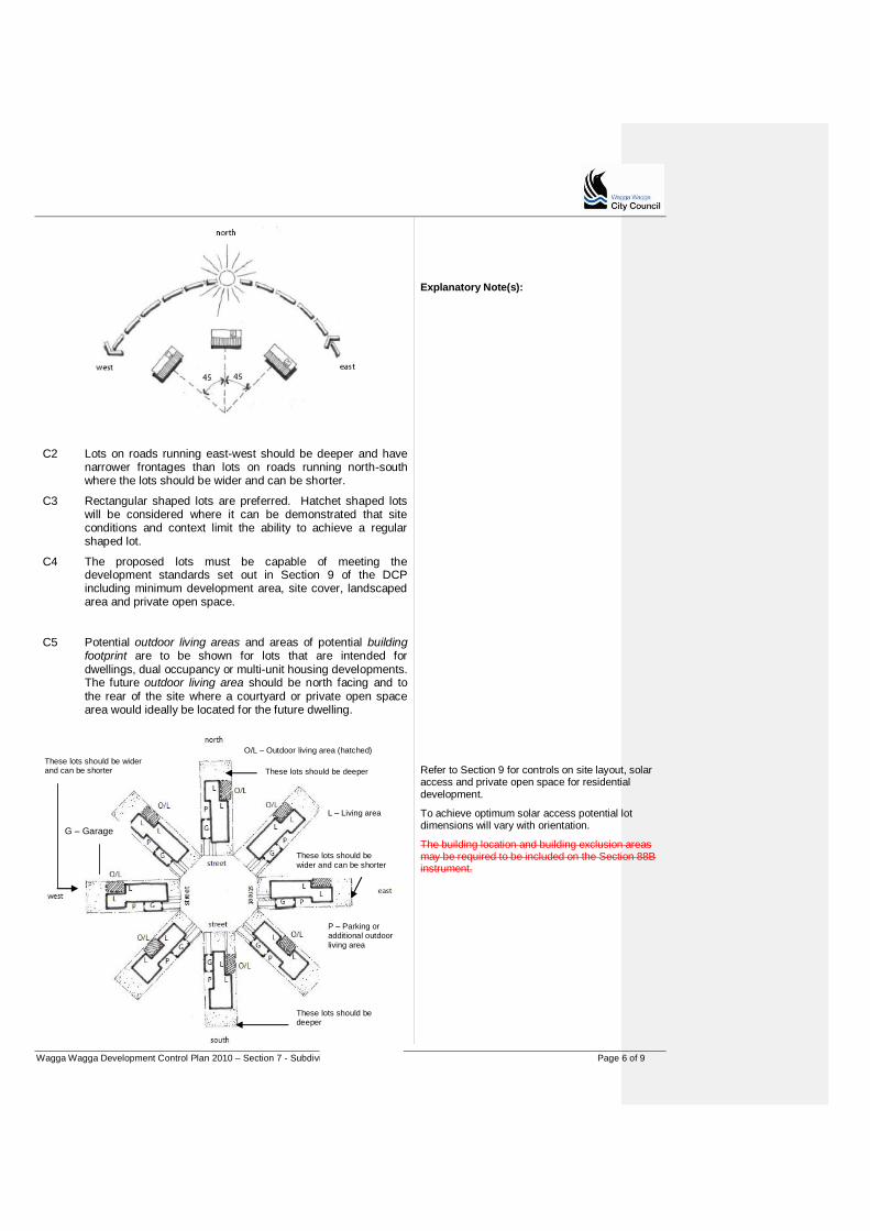
Wagga Wagga Development Control Plan 2010 – Section 7 - Subdivision Page 6 of 9
C2 Lots on roads running east-west should be deeper and have narrower frontages than lots on roads running north-south where the lots should be wider and can be shorter.
C3 Rectangular shaped lots are preferred. Hatchet shaped lots will be considered where it can be demonstrated that site conditions and context limit the ability to achieve a regular shaped lot.
C4 The proposed lots must be capable of meeting the development standards set out in Section 9 of the DCP including minimum development area, site cover, landscaped area and private open space.
Explanatory Note(s):
C5 Potential outdoor living areas and areas of potential building footprint are to be shown for lots that are intended for dwellings, dual occupancy or multi-unit housing developments. The future outdoor living area should be north facing and to the rear of the site where a courtyard or private open space area would ideally be located for the future dwelling.
Refer to Section 9 for controls on site layout, solar access and private open space for residential development.
To achieve optimum solar access potential lot dimensions will vary with orientation.
The building location and building exclusion areas may be required to be included on the Section 88B instrument.
P – Parking or additional outdoor living area
L – Living area
These lots should be wider and can be shorter
These lots should be deeper These lots should be wider and can be shorter
O/L – Outdoor living area (hatched)
G – Garage
These lots should be deeper
Wagga Wagga Development Control Plan 2010 – Section 7 - Subdivision Page 7 of 9
C6 Increase lot sizes where site conditions could constrain future development, such as sloping sites.
7.2.4 Open space, parks and the public domain
Parks and open space areas should be integral to neighbourhood design, providing a range of recreational and environmental settings, corridors and focal points. They should a response to the opportunities and constraints of the physical characteristics of the land, proposed uses and facilities. Objectives
O1 Ensure quality public open space and parks.
O2 Design and locate open space and recreation areas to maximise connections to adjoining land uses and local roads.
O3 Ensure that public open space areas are suitable for the required use and not affected by fragmentation.
Controls
C1 Locate open space and recreation areas to maximise connections to adjoining land uses and local roads.
C2 Open space areas and parks are generally not to be located under major power lines or in detention basins.
C2
C3 Drainage areas are not to be included in the calculation of area required for local open space.
Refer to the Guide (including Appendices 2, 3 & 5) and Checklist for subdivision for further details in relation to required information for the landscaping of communal (public) open space areas. An open space master plan including detailed information about the treatment and/or embellishment of open space is to be submitted with a development application for a subdivision to create 10 additional allotments. Documentation that should accompany a construction certificate for a subdivision to create 10 additional allotments should include plans, materials and finishes etc for public open space. The required plans and detailing may already have been addressed at the time of masterplan approval.
Explanatory Note(s):
Wagga Wagga Development Control Plan 2010 – Section 7 - Subdivision Page 8 of 9
C4 To avoid lines of back fences open space areas are to have frontage to at least one road.
C5 To lessen their visual impact electrical boxes and other infrastructure are to be strategically incorporated into areas of open space.
7.2.5 Water Sensitive Urban Design
The impervious surface of roads significantly increases the stormwater flows of urban areas. Road surfaces are also a source of water borne pollutants such as sediments, metals and hydrocarbons.
Water Sensitive Urban Design (WSUD) strategies use vegetation and bio-retention swales, and other stormwater treatments to reduce stormwater flows, and to collect and treat runoff prior to discharge.
A WSUD strategy is required where more than 10 lots are proposed, or where the land to be subdivided is greater than 5ha in area, and in cases where there are opportunities for mutual environmental or public benefits. WSUD measures should integrate with the stormwater systems for adjoining areas.
Objectives
O1 Require water sensitive urban design strategies to reduce stormwater flows and improve the quality of runoff from urban areas.
O2 Minimise drainage impacts on the Murrumbidgee River.
O3 Encourage stormwater treatments that maximise the visual and recreational amenity of developments.
O4 Consider future operation and maintenance requirements at the design stage.
Controls
C1 A water sensitive design strategy is required for subdivisions that result in more than 10 residential lots, or where the land to be subdivided is greater than 5ha in area.
C2 Water quality control devices may be required where there is potential for drainage to impact on the Murrumbidgee River.
C3 Design WSUD measures to minimise future operation and maintenance costs.
For larger neighbourhoods the WSUD strategy should cover the whole area (including future subdivision stages). For all „greenfield‟ sites including urban release areas, shared services trenching (of compatible services or utilities such as power and telecommunications) is preferred where such services are to be provided.
7.2.6 Services
Objectives
O1 Ensure the efficient and cost-effective provision of services.
O2 Share services trenching wherever possible for current and future provision of services and telecommunications.
Controls
C1 Subdivision can only be considered where there are appropriate arrangements for servicing (electricity, gas, water, sewer and communications).
Explanatory Note(s): For all „greenfield‟ sites including urban release areas, shared services trenching (of compatible services or utilities such as power and telecommunications) is preferred where such services are to be provided. Explanatory Note(s):
Wagga Wagga Development Control Plan 2010 – Section 7 - Subdivision Page 9 of 9
Refer to Council‟s Engineering Guidelines for Subdivision and Developments for additional detailed requirements.
7.3 Industrial Subdivisions
New developments
Industrial development proposals including subdivision should be designed after thorough consideration has been given to the environment and context within which the proposals are to be located. The design and layout of industrial development is to be such that the development does not have an inappropriate impact on the site or the amenity of the locality. Objectives
O1 To ensure that development sites have sufficient area and dimensions to provide adequately for access, landscaping, and building separation.
O2 To ensure the efficient use of urban land by maximising development potential of new and existing land and infrastructure
Controls
Minimum Subdivision Size
C1 An acceptable minimum lot size for industrial development is considered to be 2000m2 with a minimum frontage of 30m.
For the subdivision of larger parcels of industrial land, it may be desirable to open a public access way through land in order to minimise the number of means of ingress and egress, particularly those having frontage to busy public roads. This could be done either by the creation of community title “access ways” to serve rear blocks, or through the creation of dedicated public roads.
C2 For industrial lots in excess of 3000m2 with a single street frontage a minimum frontage of 40m is required. Where larger lots are located on a dual street frontage a minimum frontage is required to both streets.
Wagga Wagga Development Control Plan 2010 – Section 9 – Residential Development Page 1 of 21
PART D
Section 9 Residential Development
Table of Contents
About Section 9 ..................................................................................................... 2 Principles for residential development ................................................................... 2
9.1 Land Use Directions................................................................................. 3 9.1.1 Central Wagga Wagga............................................................................. 3
9.1.2 R1 Zone – established suburbs ............................................................... 3 9.1.3 R3 (medium density) Zone in-fill potential ................................................ 4
9.1.4 R3 Zone – redevelopment areas ............................................................. 8 9.2 Site context and layout............................................................................. 8
9.2.1 Site layout ................................................................................................ 9 9.2.2 Streetscape ............................................................................................ 10
9.2.3 Corner lots and secondary facades ....................................................... 10 9.2.4 Sloping sites .......................................................................................... 11
9.3 Site area, building form and envelope.................................................... 11 9.3.1 Land area per dwelling........................................................................... 11
9.3.2 Site cover ............................................................................................... 12 9.3.3 R3 Zones - Minimum frontage ............................................................... 14
9.3.4 Solar access .......................................................................................... 14 9.3.5 Private open space ................................................................................ 15
9.3.6 Front setbacks ....................................................................................... 16 9.3.7 Side and rear setbacks .......................................................................... 16
9.4 Design details ........................................................................................ 17 9.4.1 Building elements .................................................................................. 18
9.4.2 Materials and finishes ............................................................................ 18 9.4.3 Privacy ................................................................................................... 19
9.4.4 Garages and driveways ......................................................................... 19 9.4.5 Site facilities ........................................................................................... 20
Wagga Wagga Development Control Plan 2010 – Section 9 – Residential Development Page 2 of 21
About Section 9
Section 9 contains the controls for residential development. The controls apply to all residential development applications unless specified in the heading.
The land use directions in Section 9.1 provide a guide to the intended type, form and density of future development in these areas.
The controls in Section 9.2 relate to site context and layout including site planning/layout and streetscape, and controls specifically for corner lots and sloping sites.
Section 9.3 contains controls relating to site area, building form and envelope, including controls on site cover, landscaped area, setbacks and solar access.
Section 9.4 contains controls relating to design details that encourage good building form, quality private open space and good amenity outcomes.
Explanatory Note(s):
Refer to Part A for submission requirements and other general matters.
Refer to Part B for requirements relating to particular environmental and landscape issues
Complying with this DCP The controls in the DCP support the Guiding Principles and Section Objectives. A Development Application mustshould aim to satisfy the Guiding Principles, and the Objectives of the relevant sections. Equal emphasis must be given to both "numeric" and non-numeric controls relevant to a particular development. Where a proposed development has an unacceptable impact on neighbours or the surrounding environment cCompliance with controls will not necessarily guarantee approval of an application. Where a variation is sought to controls, the application must document the reasons and extent of the variation, and how the variation meets the Guiding Principles and Section Objectives for the consideration of the Council.
Principles for residential development
Sustainability and efficient use of resources
P1 Use passive solar design principles to maximise thermal performance for good internal amenity.
P2 Select materials to support good thermal performance and maximise the sustainability of the design.
P3 Achieve a density and scale that reflects the zone and proximity of the site to transport, shops, schools or community uses.
P4 Implement resource reuse
Greywater Reuse Systems
Greywater is the waste water which originates from domestic plumbing fixtures such as showers, baths, spas, hand basins, laundry, and washing machines. It does not include waste water from toilets, urinals or kitchens.
The practice of grey water reuse should not impact adversely impacts upon the environment or human health.
Design quality
P5 Building siting, footprint, scale and bulk should be compatible with adjoining development and the established or intended built form.
P6 Integrate building design and landscaping with north facing internal living areas that link to quality private open space.
Site responsive development
P7 Respond to the issues highlighted in the site analysis, taking advantage of natural features, minimising potential impacts to neighbours and achieving compatibility with neighbourhood character.
P8 Minimise changes to the natural landform, especially in environmentally sensitive or visually prominent areas.
P9 Visual and acoustic privacy are important for good residential amenity. When designing new developments care should be exercised to ensure that impacts on the privacy of adjoining
The Installation and operation of Greywater Treatment Systems must comply with Council‟s Greywater Reuse Management Plan
A person must not carry out works related to the installation and operation of Domestic Greywater Treatment System (DGTS) or the operation of a Greywater Diversion Device (GDD) for residences if alteration to existing plumbing works occurs without the approval of Council.
Council shall not approve the installation of a Greywater Treatment
System, unless the requirements of the Greywater Reuse Management Plan can be achieved and the system has been accredited by NSW Health.
Wagga Wagga Development Control Plan 2010 – Section 9 – Residential Development Page 3 of 21
developments is minimised when designing new development and to ensure the privacy of occupants of the new development.
Quality public domain
P10 Provide an attractive street address that integrates the public and private domain through landscaping and attractive fencing.
Explanatory Note(s):
9.1 Land Use Directions
9.1.1 Central Wagga Wagga
Existing built form
The residential streets of Wagga Wagga‟s central business area have a strong landscape character associated with the mature street trees. There absence of garages and parking structures in the streetscape is a function of the rear lane access of many streets, and allows the landscape to dominate.
The consistent built form and setbacks contribute to the coherent character of the area. Buildings are typically single storey, and often have consistent rear building lines with reasonable gardens. The site cover and landscaped area controls are intended to discourage patterns of excessive site cover, and to retain the pattern of buildings and open space.
Future directions and opportunities
Key priorities for the central business area of Wagga Wagga are:
Opportunities for secondary dwellings fronting rear lanes providing new work does not affect the amenity of adjoining sites and parking can be accommodated without impacting the street
Retaining the existing landscaped character of the streets, and maintaining the use of the rear lanes for vehicle access and associated structures
Retaining the current patterns of building/open areas through site cover and landscaped area requirements.
9.1.2 R1 Zone – established suburbs
Existing built form
Wagga Wagga‟s established suburbs are characterised by predominantly single storey detached dwellings. Most streets have consistent front setbacks of 6m, although in some suburbs the front setbacks are 7.5m.
The trend towards larger dwelling “footprints”, combined with the generous front setbacks, means that there is often not much space at the rear of the dwelling for a “good back yard”. The Residential Design Principles and DCP controls encourage future development to rethink residential design to improve thermal performance, and make better use of orientation and site conditions.
Future directions and opportunities
The LEP allows a range of housing types in the R1 Zone. Where possible developments should seek to include different dwelling types, such as secondary dwellings and attached dwellings, to achieve variety and housing choice for future residents, especially where the site characteristics or location are suitable.
Future development should respect the established character in the vicinity of the site, and aim to contribute positively to the streetscape and overall environmental quality of the locality.
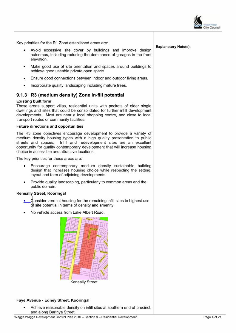
Wagga Wagga Development Control Plan 2010 – Section 9 – Residential Development Page 4 of 21
Key priorities for the R1 Zone established areas are:
Avoid excessive site cover by buildings and improve design outcomes, including reducing the dominance of garages in the front elevation.
Make good use of site orientation and spaces around buildings to achieve good useable private open space.
Ensure good connections between indoor and outdoor living areas.
Incorporate quality landscaping including mature trees.
9.1.3 R3 (medium density) Zone in-fill potential
Existing built form These areas support villas, residential units with pockets of older single dwellings and sites that could be consolidated for further infill development developments. Most are near a local shopping centre, and close to local transport routes or community facilities.
Explanatory Note(s):
Future directions and opportunities
The R3 zone objectives encourage development to provide a variety of medium density housing types with a high quality presentation to public streets and spaces. Infill and redevelopment sites are an excellent opportunity for quality contemporary development that will increase housing choice in accessible and attractive locations.
The key priorities for these areas are:
Encourage contemporary medium density sustainable building design that increases housing choice while respecting the setting, layout and form of adjoining developments
Provide quality landscaping, particularly to common areas and the public domain.
Keneally Street, Kooringal
Consider zero lot housing for the remaining infill sites to highest use of site potential in terms of density and amenity
No vehicle access from Lake Albert Road.
Keneally Street
Faye Avenue - Edney Street, Kooringal
Achieve reasonable density on infill sites at southern end of precinct, and along Barinya Street.
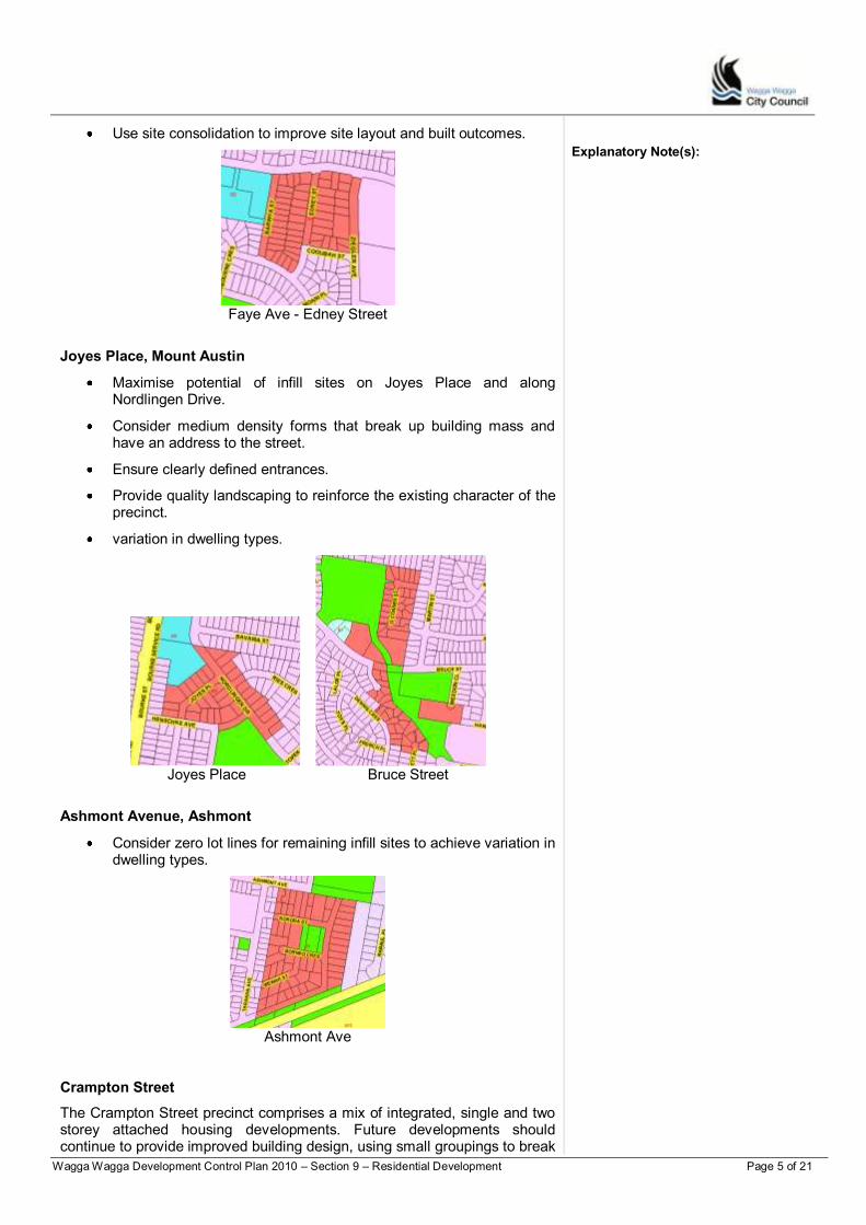
Wagga Wagga Development Control Plan 2010 – Section 9 – Residential Development Page 5 of 21
Use site consolidation to improve site layout and built outcomes.
Faye Ave - Edney Street
Joyes Place, Mount Austin
Maximise potential of infill sites on Joyes Place and along Nordlingen Drive.
Consider medium density forms that break up building mass and have an address to the street.
Ensure clearly defined entrances.
Provide quality landscaping to reinforce the existing character of the precinct.
variation in dwelling types.
Joyes Place Bruce Street
Ashmont Avenue, Ashmont
Consider zero lot lines for remaining infill sites to achieve variation in dwelling types.
Ashmont Ave
Crampton Street
The Crampton Street precinct comprises a mix of integrated, single and two storey attached housing developments. Future developments should continue to provide improved building design, using small groupings to break
Explanatory Note(s):
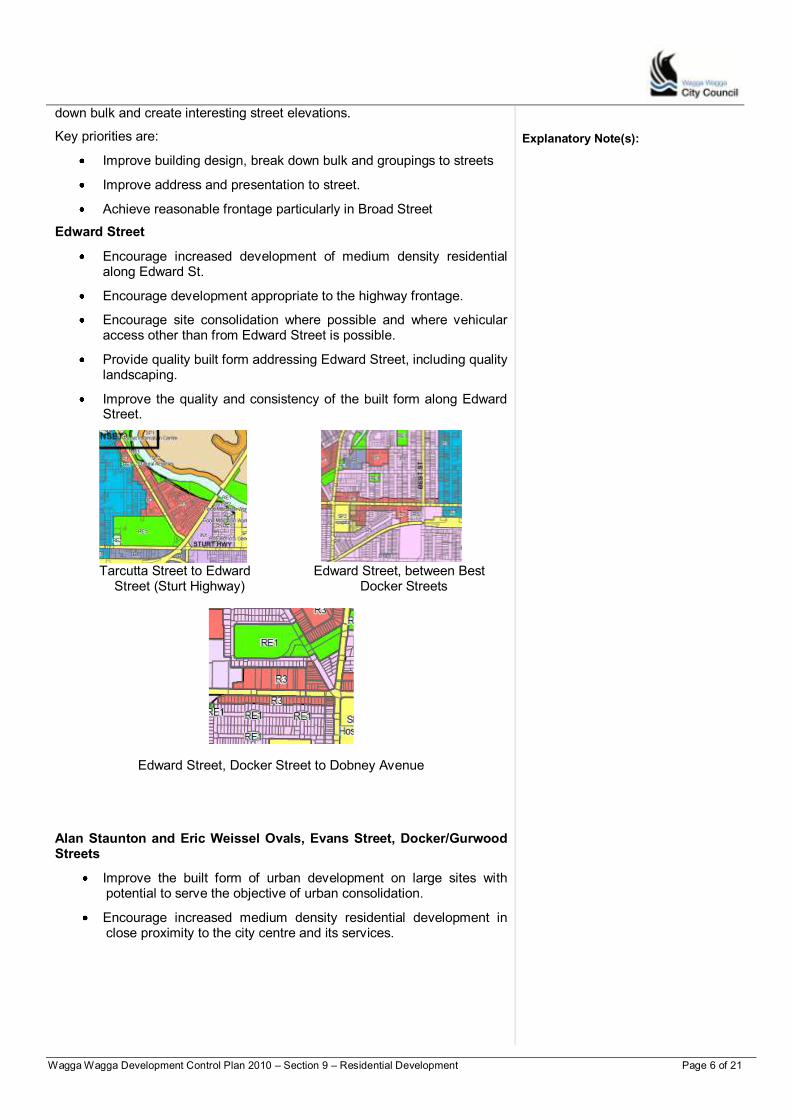
Wagga Wagga Development Control Plan 2010 – Section 9 – Residential Development Page 6 of 21
down bulk and create interesting street elevations.
Key priorities are:
Improve building design, break down bulk and groupings to streets
Improve address and presentation to street.
Achieve reasonable frontage particularly in Broad Street
Edward Street
Encourage increased development of medium density residential along Edward St.
Encourage development appropriate to the highway frontage.
Encourage site consolidation where possible and where vehicular access other than from Edward Street is possible.
Provide quality built form addressing Edward Street, including quality landscaping.
Improve the quality and consistency of the built form along Edward Street.
Tarcutta Street to Edward Edward Street, between Best
Street (Sturt Highway) Docker Streets
Edward Street, Docker Street to Dobney Avenue
Alan Staunton and Eric Weissel Ovals, Evans Street, Docker/Gurwood Streets
Improve the built form of urban development on large sites with potential to serve the objective of urban consolidation.
Encourage increased medium density residential development in close proximity to the city centre and its services.
Explanatory Note(s):
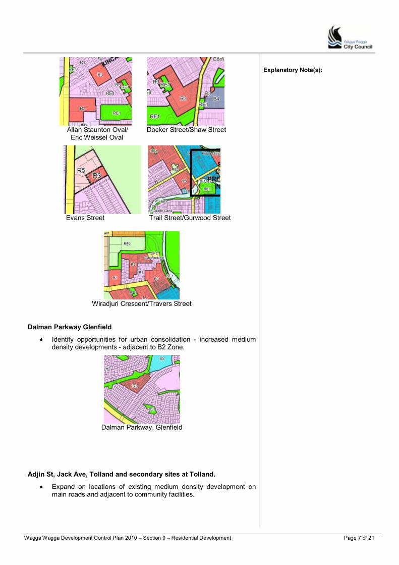
Wagga Wagga Development Control Plan 2010 – Section 9 – Residential Development Page 7 of 21
Allan Staunton Oval/ Docker Street/Shaw Street
Eric Weissel Oval
Evans Street Trail Street/Gurwood Street
Wiradjuri Crescent/Travers Street
Dalman Parkway Glenfield
Identify opportunities for urban consolidation - increased medium density developments - adjacent to B2 Zone.
Dalman Parkway, Glenfield
Adjin St, Jack Ave, Tolland and secondary sites at Tolland.
Expand on locations of existing medium density development on main roads and adjacent to community facilities.
Explanatory Note(s):
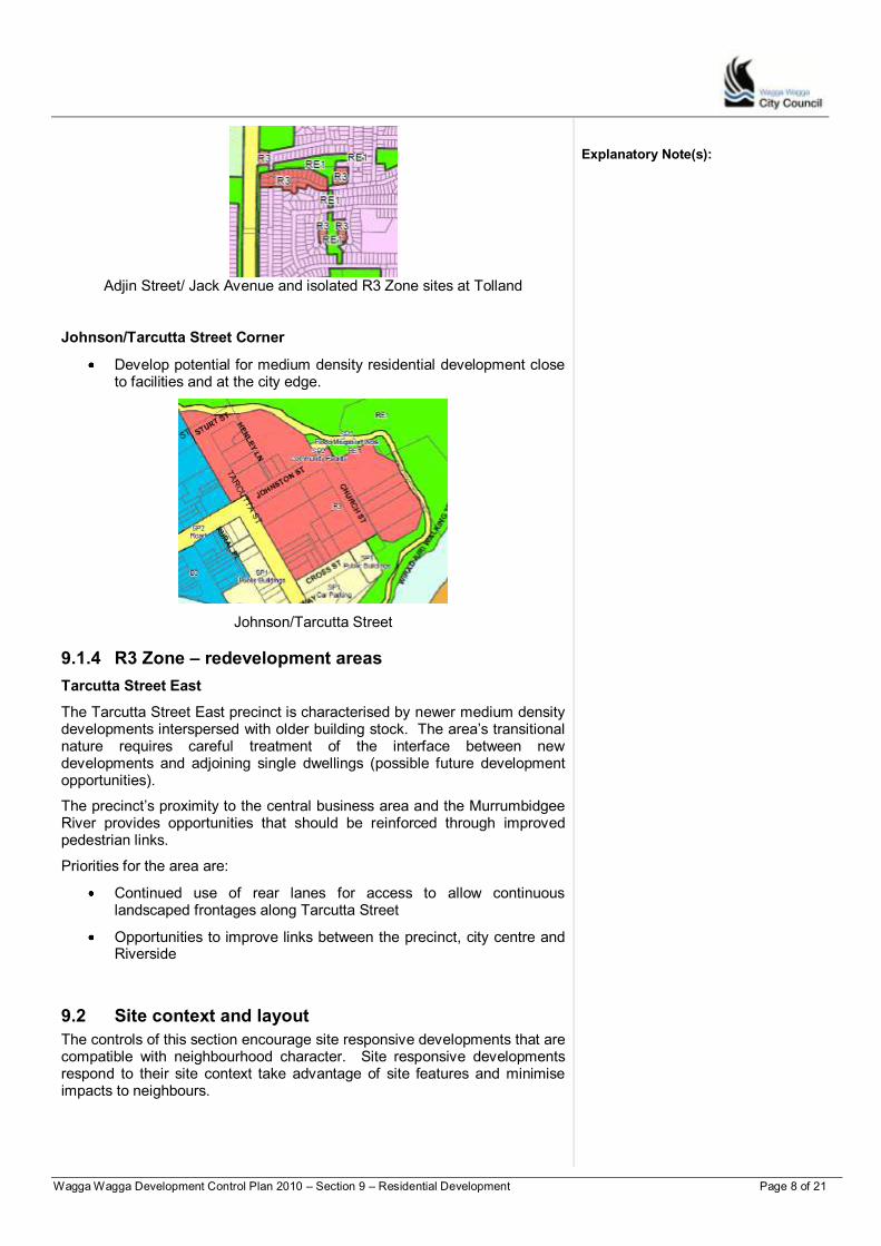
Wagga Wagga Development Control Plan 2010 – Section 9 – Residential Development Page 8 of 21
Adjin Street/ Jack Avenue and isolated R3 Zone sites at Tolland
Johnson/Tarcutta Street Corner
Develop potential for medium density residential development close to facilities and at the city edge.
Johnson/Tarcutta Street
Explanatory Note(s):
9.1.4 R3 Zone – redevelopment areas
Tarcutta Street East
The Tarcutta Street East precinct is characterised by newer medium density developments interspersed with older building stock. The area‟s transitional nature requires careful treatment of the interface between new developments and adjoining single dwellings (possible future development opportunities).
The precinct‟s proximity to the central business area and the Murrumbidgee River provides opportunities that should be reinforced through improved pedestrian links.
Priorities for the area are:
Continued use of rear lanes for access to allow continuous landscaped frontages along Tarcutta Street
Opportunities to improve links between the precinct, city centre and Riverside
9.2 Site context and layout
The controls of this section encourage site responsive developments that are compatible with neighbourhood character. Site responsive developments respond to their site context take advantage of site features and minimise impacts to neighbours.
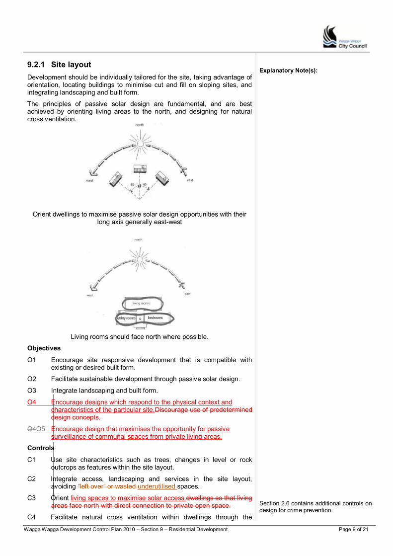
Wagga Wagga Development Control Plan 2010 – Section 9 – Residential Development Page 9 of 21
9.2.1 Site layout
Development should be individually tailored for the site, taking advantage of orientation, locating buildings to minimise cut and fill on sloping sites, and integrating landscaping and built form.
The principles of passive solar design are fundamental, and are best achieved by orienting living areas to the north, and designing for natural cross ventilation.
Orient dwellings to maximise passive solar design opportunities with their long axis generally east-west
Explanatory Note(s):
Living rooms should face north where possible.
Objectives
O1 Encourage site responsive development that is compatible with existing or desired built form.
O2 Facilitate sustainable development through passive solar design.
O3 Integrate landscaping and built form.
O4 Encourage designs which respond to the physical context and characteristics of the particular site.Discourage use of predetermined design concepts.
O4O5 Encourage design that maximises the opportunity for passive surveillance of communal spaces from private living areas.
Controls
C1 Use site characteristics such as trees, changes in level or rock outcrops as features within the site layout.
C2 Integrate access, landscaping and services in the site layout, avoiding “left over” or wasted underutilised spaces.
C3 Orient living spaces to maximise solar access.dwellings so that living areas face north with direct connection to private open space.
C4 Facilitate natural cross ventilation within dwellings through the
Section 2.6 contains additional controls on design for crime prevention.
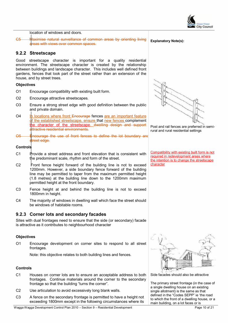
Wagga Wagga Development Control Plan 2010 – Section 9 – Residential Development Page 10 of 21
location of windows and doors.
C5 Maximise natural surveillance of common areas by orienting living areas with views over common spaces.
9.2.2 Streetscape
Good streetscape character is important for a quality residential environment. The streetscape character is created by the relationship between buildings and landscape character. This includes well defined front gardens, fences that look part of the street rather than an extension of the house, and by street trees.
Objectives
O1 Encourage compatibility with existing built form.
O2 Encourage attractive streetscapes.
O3 Ensure a strong street edge with good definition between the public and private domain.
O4 In locations where front Encourage fences are an important feature of the established streetscape, ensure that new fences complement the character of the streetscape. dwelling design and support attractive residential environments.
O5 Encourage the use of front fences to define the lot boundary and street edge.
Controls
C1 Provide a street address and front elevation that is consistent with the predominant scale, rhythm and form of the street.
C2 Front fence height forward of the building line is not to exceed 1200mm. However, a side boundary fence forward of the building line may be permitted to taper from the maximum permitted height (1.8 metres) at the building line down to the 1200mm maximum permitted height at the front boundary.
C3 Fence height at and behind the building line is not to exceed 1800mm in height.
C4 The majority of windows in dwelling wall which face the street should be windows of habitable rooms.
Explanatory Note(s):
Post and rail fences are preferred in semi-rural and rural residential settings
Compatibility with existing built form is not required in redevelopment areas where the intention is to change the streetscape character
9.2.3 Corner lots and secondary facades
Sites with dual frontages need to ensure that the side (or secondary) facade is attractive as it contributes to neighbourhood character
Objectives
O1 Encourage development on corner sites to respond to all street frontages.
Note: this objective relates to both building lines and fences.
Controls
C1 Houses on corner lots are to ensure an acceptable address to both frontages. Continue materials around the corner to the secondary frontage so that the building “turns the corner”.
C2 Use articulation to avoid excessively long blank walls.
C3 A fence on the secondary frontage is permitted to have a height not exceeding 1800mm except in the following circumstances where its
Side facades should also be attractive
The primary street frontage (in the case of a single dwelling house on an existing single allotment) is the same as that defined in the “Codes SEPP” ie „the road to which the front of a dwelling house, or a main building, on a lot faces or is

Wagga Wagga Development Control Plan 2010 – Section 9 – Residential Development Page 11 of 21
height is not to exceed 1200mm:
Where it enters and is within the building line of the primary
frontage - within the building line a fence will be permitted to taper down from 1800mm maximum permitted height to the 1200mm maximum permitted height at the primary frontage boundary”
Where a dwelling “addresses” the secondary frontage
9.2.4 Sloping sites
Development on Wagga Wagga‟s hills requires careful attention to protect the town‟sCity‟s visual setting. Building designs should accommodate sloping sites, rather than the other way around – using cut and fill to create a level site. Appropriate building designs for sloping sites use split level, pier foundation or suspended floor designs.
Objectives
O1 Encourage site responsive development.
O2 Encourage building design that is appropriate to the site conditions.
O2O3 If an alternate design is possible, avoid development that would require cutting into the site.
Controls
C1 Use pier, split level or suspended floor designs on sloping sites.
proposed to face‟. The remaining street frontage becomes the secondary frontage.
Explanatory Note(s): The rear boundary will become the opposite of the primary road boundary and the side boundary will be the remaining boundary
Refer to Section 2.7 for controls on excavation, cut and fill.
Use split level construction on sloping sites
9.3 Site area, building form and envelope
The site area, building form, scale and bulk should be appropriate to the established or intended built form of the locality. Site cover, landscaped area, setbacks and solar access are the main controls to ensure appropriate bulk and mass.
9.3.1 Land area per dwelling
Residential developments need sufficient space for setbacks to ensure adequate space between buildings, and for private open space and landscaping. The land area per dwelling requirement is important to ensure that developments do not rely on adjoining land to effectively “provide the green space” to make the houses liveable while ensuring appropriate densities are achieved in the R3 Zone.
Objectives
O1 Ensure adequate area to provide separation between buildings, landscaping and private open space.
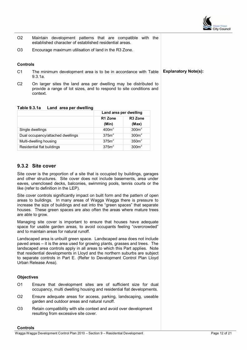
Wagga Wagga Development Control Plan 2010 – Section 9 – Residential Development Page 12 of 21
O2 Maintain development patterns that are compatible with the established character of established residential areas.
O3 Encourage maximum utilisation of land in the R3 Zone.
Controls
C1 The minimum development area is to be in accordance with Table 9.3.1a.
C2 On larger sites the land area per dwelling may be distributed to provide a range of lot sizes, and to respond to site conditions and context.
Table 9.3.1a Land area per dwelling
Explanatory Note(s):
Land area per dwelling
R1 Zone
(Min)
R3 Zone
(Max)
Single dwellings 400m2 300m
2
Dual occupancy/attached dwellings 375m2
300m2
Multi-dwelling housing 375m2 350m
2
Residential flat buildings 375m2
300m2
9.3.2 Site cover
Site cover is the proportion of a site that is occupied by buildings, garages and other structures. Site cover does not include basements, area under eaves, unenclosed decks, balconies, swimming pools, tennis courts or the like (refer to definition in the LEP).
Site cover controls significantly impact on built form and the pattern of open areas to buildings. In many areas of Wagga Wagga there is pressure to increase the size of buildings and eat into the “green spaces” that separate houses. These green spaces are also often the areas where mature trees are able to grow.
Managing site cover is important to ensure that houses have adequate space for usable garden areas, to avoid occupants feeling “overcrowded” and to maintain areas for natural runoff.
Landscaped area is unbuilt green space. Landscaped area does not include paved areas – it is the area used for growing plants, grasses and trees. The landscaped area controls apply in all areas to which this Part applies. Note that residential developments in Lloyd and the northern suburbs are subject to separate controls in Part E. (Refer to Development Control Plan Lloyd Urban Release Area).
Objectives
O1 Ensure that development sites are of sufficient size for dual occupancy, multi dwelling housing and residential flat developments.
O2 Ensure adequate areas for access, parking, landscaping, useable garden and outdoor areas and natural runoff.
O3 Retain compatibility with site context and avoid over development resulting from excessive site cover.
Controls
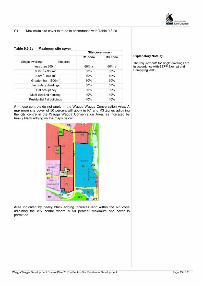
Wagga Wagga Development Control Plan 2010 – Section 9 – Residential Development Page 13 of 21
C1 Maximum site cover is to be in accordance with Table 9.3.2a.
Table 9.3.2a Maximum site cover Site cover (max)
R1 Zone R3 Zone
Single dwellings1 site area
less than 600m2
60% # 60% #
600m2 – 900m
2 50% 50%
900m2- 1500m
2 40% 40%
Greater than 1500m2 30% 30%
Secondary dwellings 50% 50%
Dual occupancy 50% 50%
Multi-dwelling housing 40% 40%
Residential flat buildings 40% 40%
# - these controls do not apply in the Wagga Wagga Conservation Area. A maximum site cover of 50 percent will apply in R1 and R3 Zones adjoining the city centre in the Wagga Wagga Conservation Area, as indicated by heavy black edging on the maps below.
Area indicated by heavy black edging indicates land within the R3 Zone adjoining the city centre where a 50 percent maximum site cover is permitted.
Explanatory Note(s):
The requirements for single dwellings are in accordance with SEPP Exempt and Complying 2008.

Wagga Wagga Development Control Plan 2010 – Section 9 – Residential Development Page 14 of 21
Area indicated by heavy black edging indicates land in the vicinity of Tarcutta Street within the R3 Zone adjoining the city centre where a 50 percent maximum site cover is permitted.
Explanatory Note(s):
9.3.3 R3 Zones - Minimum frontage
Minimum frontages are required for multi dwelling housing and residential flat developments in the R3 Zone. The minimum frontage requirement is intended to ensure adequately proportioned development sites.
Objectives
O1 Ensure that multi dwelling housing and residential flat developments occur on suitably sized lots.
O2 Support the intentions of the R3 Zone to encourage medium density developments.
Controls
C1 Multi dwelling housing and residential flat developments are required to have a minimum frontage of 20m to the primary address.
Variations can be considered to the minimum frontage requirement where it can be demonstrated that the resulting development achieves a reasonable density and can satisfy the amenity considerations of this Section.
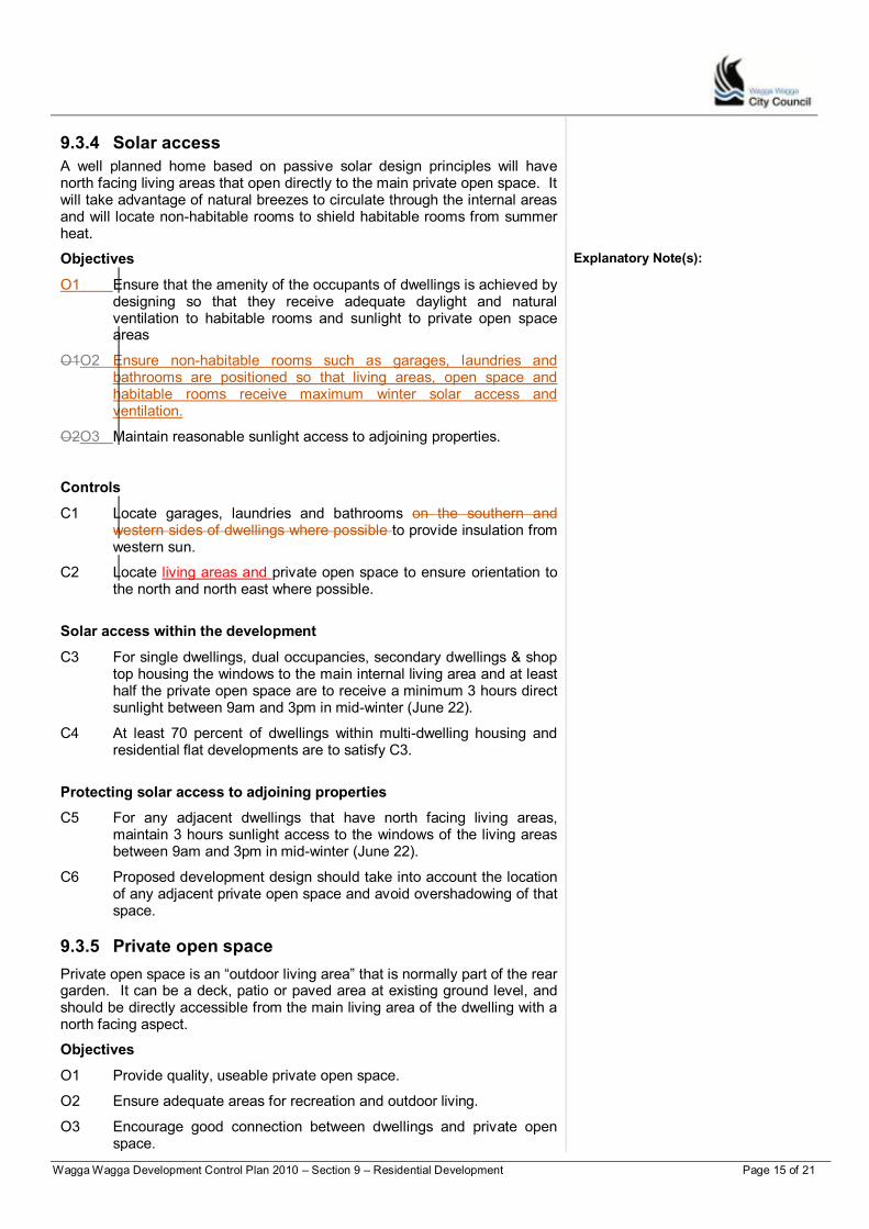
Wagga Wagga Development Control Plan 2010 – Section 9 – Residential Development Page 15 of 21
9.3.4 Solar access
A well planned home based on passive solar design principles will have north facing living areas that open directly to the main private open space. It will take advantage of natural breezes to circulate through the internal areas and will locate non-habitable rooms to shield habitable rooms from summer heat.
Objectives
O1 Ensure that the amenity of the occupants of dwellings is achieved by designing so that they receive adequate daylight and natural ventilation to habitable rooms and sunlight to private open space areas
O1O2 Ensure non-habitable rooms such as garages, laundries and bathrooms are positioned so that living areas, open space and habitable rooms receive maximum winter solar access and ventilation.
O2O3 Maintain reasonable sunlight access to adjoining properties.
Explanatory Note(s):
Controls
C1 Locate garages, laundries and bathrooms on the southern and western sides of dwellings where possible to provide insulation from western sun.
C2 Locate living areas and private open space to ensure orientation to the north and north east where possible.
Solar access within the development
C3 For single dwellings, dual occupancies, secondary dwellings & shop top housing the windows to the main internal living area and at least half the private open space are to receive a minimum 3 hours direct sunlight between 9am and 3pm in mid-winter (June 22).
C4 At least 70 percent of dwellings within multi-dwelling housing and residential flat developments are to satisfy C3.
Protecting solar access to adjoining properties
C5 For any adjacent dwellings that have north facing living areas, maintain 3 hours sunlight access to the windows of the living areas between 9am and 3pm in mid-winter (June 22).
C6 Proposed development design should take into account the location of any adjacent private open space and avoid overshadowing of that space.
9.3.5 Private open space
Private open space is an “outdoor living area” that is normally part of the rear garden. It can be a deck, patio or paved area at existing ground level, and should be directly accessible from the main living area of the dwelling with a north facing aspect.
Objectives
O1 Provide quality, useable private open space.
O2 Ensure adequate areas for recreation and outdoor living.
O3 Encourage good connection between dwellings and private open space.
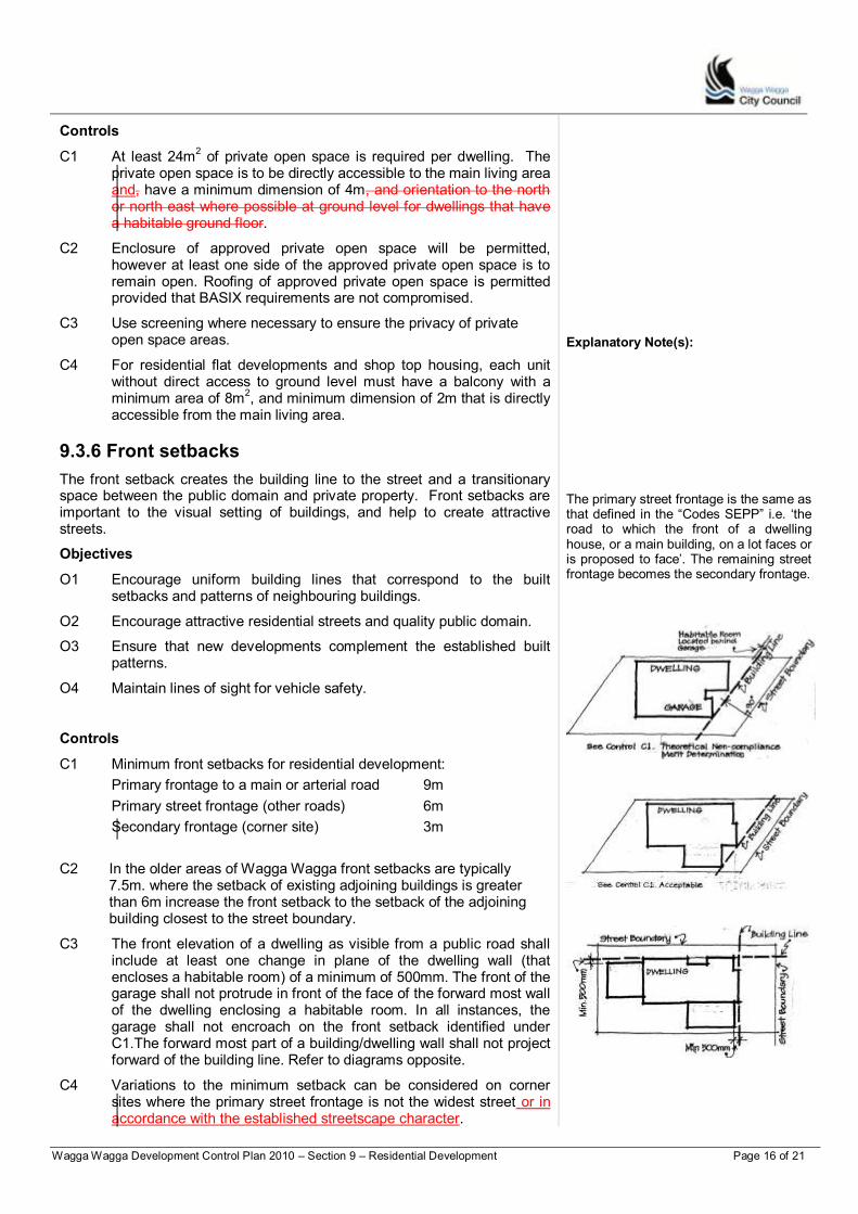
Wagga Wagga Development Control Plan 2010 – Section 9 – Residential Development Page 16 of 21
Controls
C1 At least 24m2 of private open space is required per dwelling. The
private open space is to be directly accessible to the main living area and, have a minimum dimension of 4m, and orientation to the north or north east where possible at ground level for dwellings that have a habitable ground floor.
C2 Enclosure of approved private open space will be permitted, however at least one side of the approved private open space is to remain open. Roofing of approved private open space is permitted provided that BASIX requirements are not compromised.
C3 Use screening where necessary to ensure the privacy of private open space areas.
C4 For residential flat developments and shop top housing, each unit without direct access to ground level must have a balcony with a minimum area of 8m
2, and minimum dimension of 2m that is directly
accessible from the main living area.
9.3.6 Front setbacks
The front setback creates the building line to the street and a transitionary space between the public domain and private property. Front setbacks are important to the visual setting of buildings, and help to create attractive streets.
Objectives
O1 Encourage uniform building lines that correspond to the built setbacks and patterns of neighbouring buildings.
O2 Encourage attractive residential streets and quality public domain.
O3 Ensure that new developments complement the established built patterns.
O4 Maintain lines of sight for vehicle safety.
Controls
C1 Minimum front setbacks for residential development:
Primary frontage to a main or arterial road 9m
Primary street frontage (other roads) 6m
Secondary frontage (corner site) 3m
C2 In the older areas of Wagga Wagga front setbacks are typically 7.5m. where the setback of existing adjoining buildings is greater than 6m increase the front setback to the setback of the adjoining building closest to the street boundary.
C3 The front elevation of a dwelling as visible from a public road shall include at least one change in plane of the dwelling wall (that encloses a habitable room) of a minimum of 500mm. The front of the garage shall not protrude in front of the face of the forward most wall of the dwelling enclosing a habitable room. In all instances, the garage shall not encroach on the front setback identified under C1.The forward most part of a building/dwelling wall shall not project forward of the building line. Refer to diagrams opposite.
C4 Variations to the minimum setback can be considered on corner sites where the primary street frontage is not the widest street or in accordance with the established streetscape character.
Explanatory Note(s):
The primary street frontage is the same as that defined in the “Codes SEPP” i.e. „the road to which the front of a dwelling house, or a main building, on a lot faces or is proposed to face‟. The remaining street frontage becomes the secondary frontage.
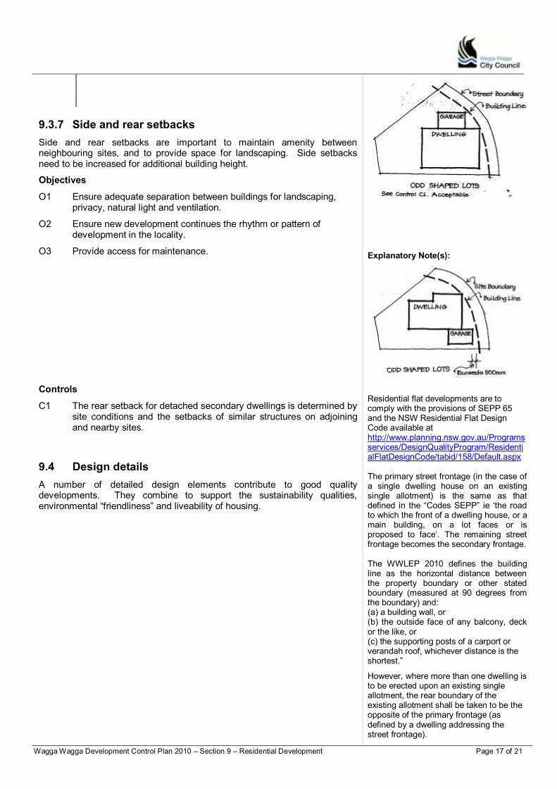
Wagga Wagga Development Control Plan 2010 – Section 9 – Residential Development Page 17 of 21
9.3.7 Side and rear setbacks
Side and rear setbacks are important to maintain amenity between neighbouring sites, and to provide space for landscaping. Side setbacks need to be increased for additional building height.
Objectives
O1 Ensure adequate separation between buildings for landscaping, privacy, natural light and ventilation.
O2 Ensure new development continues the rhythm or pattern of development in the locality.
O3 Provide access for maintenance.
Explanatory Note(s):
Controls
C1 The rear setback for detached secondary dwellings is determined by site conditions and the setbacks of similar structures on adjoining and nearby sites.
9.4 Design details
A number of detailed design elements contribute to good quality developments. They combine to support the sustainability qualities, environmental “friendliness” and liveability of housing.
Residential flat developments are to comply with the provisions of SEPP 65 and the NSW Residential Flat Design Code available at http://www.planning.nsw.gov.au/Programsservices/DesignQualityProgram/ResidentialFlatDesignCode/tabid/158/Default.aspx The primary street frontage (in the case of a single dwelling house on an existing single allotment) is the same as that defined in the “Codes SEPP” ie „the road to which the front of a dwelling house, or a main building, on a lot faces or is proposed to face‟. The remaining street frontage becomes the secondary frontage. The WWLEP 2010 defines the building line as the horizontal distance between the property boundary or other stated boundary (measured at 90 degrees from the boundary) and: (a) a building wall, or (b) the outside face of any balcony, deck or the like, or (c) the supporting posts of a carport or verandah roof, whichever distance is the shortest.”
However, where more than one dwelling is to be erected upon an existing single allotment, the rear boundary of the existing allotment shall be taken to be the opposite of the primary frontage (as defined by a dwelling addressing the street frontage).

Wagga Wagga Development Control Plan 2010 – Section 9 – Residential Development Page 18 of 21
Where a unit(s) or dwelling(s) also addresses a second frontage of a corner allotment, the rear boundary will vary according to the unit or dwelling under consideration and is taken to be the boundary opposite to that which that dwelling(s)/unit(s) face, providing that such boundary abuts a boundary of an existing allotment.
The remaining boundary will be regarded as a side boundary”.
9.4.1 Building elements
Quality built form is supported by clever use of building elements such as balconies, eaves, sun shading devices and appropriate use of materials.
Objectives
O1 Encourage quality and visually interesting buildings through the use of building elements.
O2 Facilitate passive solar design principles.
Explanatory Note(s):
Controls
C1 Provide roof eaves for shading and weather protection over east and west facing walls, windows and doors.
C2 Incorporate sun shades to windows on north and west facing elevations.
C3C1 Use verandahs or pergolas to link internal and external living areas.
C4C2 Porches are to be integrated into the building design, and are to be used to create a sheltered and clearly visible entry.
C5C3 Locate ancillary components such as aerials, satellite dishes, air conditioning units and the like so on rear elevations or where they are not visible from the street.
C6C4 For dual occupancy developments, each dwelling is to have a separate entry.
C7C5 Secondary dwellings are to appear as a single occupancy from the public domain.
9.4.2 Materials and finishes
Cladding materials should be environmentally responsive and should contribute to a quality streetscape.
Objectives
O1 Encourage the use of external materials and finishes that are suited to their location and support consistent quality streetscapes.
O2 Encourage use of materials that have good thermal performance.
O3 Promote the use of materials that are climate responsive and contribute to innovative building design.
O4 Discourage corporate colours in building facades.

Wagga Wagga Development Control Plan 2010 – Section 9 – Residential Development Page 19 of 21
Controls
C1 Select materials for their environmental performance, durability, detail and appearance to achieve quality appearance.
C2 Avoid large unbroken expanses of any single material.
C3 Minimise use of highly reflective or glossy materials on building exteriors.
C4 Use contrasting materials in combination with design elements for features such as corner elements.
C5 For larger developments, use recessive colours for the upper levels to help minimise building bulk.
C6 For non-residential developments, corporate colours are not to dominate the building facade.
9.4.3 Privacy
Visual and acoustic privacy are important for good residential amenity. The site analysis should identify potential threats to privacy and areas where special attention is required to minimise potential impacts to adjoining and nearby properties.
Explanatory Note(s):
Objectives
O1 Ensure privacy within new developments, and avoid potential impacts to existing properties.
O2 Ensure adequate acoustic privacy within dwellings.
Controls
Visual privacy
C1 Offset windows, balconies and private open space areas between adjoining dwellings.
C2 For multi-dwelling housing and residential flat developments, provide separation in accordance with Table 9.4.4a.
Table 9.4.4a Separation between buildings
Building height
Separation between habitable
rooms
Separation between
balconies and non-habitable
rooms
Separation between
non-habitable
rooms
Up to 4 storeys (12m) 12m 9m 6m
Between 5 and 8 storeys (up to 25m)
18m 13m 9m
A reduction in separation distances may be acceptable where alternate design elements which achieve privacy objectives are provided. These include (but are limited to) opaque screens of appropriate dimensions, translucent or highlight windows. Where such elements are effectively provided a minimum 6m separation distances may be considered.
Achieving acoustic privacy
Dwellings on main roads or near the railway line may be exposed to high noise levels. Attenuation can be achieved by using:
Brick, brick veneer or block work construction with fibre insulation in wall and roof cavities
Solid core external doors with seals
6mm glass with acoustic seals.
Council may impose conditions on the location and detail of any mechanical ventilation or air conditioning equipment to minimise noise intrusion within the development and to adjoining dwellings.
Wagga Wagga Development Control Plan 2010 – Section 9 – Residential Development Page 20 of 21
C3 Screening is required where there is direct line of sight between neighbouring balconies or private open space areas, or between windows and door openings of habitable rooms.
9.4.4 Garages and driveways
Garages and driveways should not dominate the street elevation of residential developments.
Objectives
O1 Minimise the visual dominance of garages and driveways in the streetscape.
O2 Where possible, locate garages so as to assist in protecting dwellings from early morning and late afternoon summer sun.
Controls
C1 Except where a dwelling lot has a street frontage of less than 14m, garage doors are not to occupy more than half the width of the street facade of the dwelling.
The primary street frontage is the same as that defined in the “Codes SEPP” ie „the road to which the front of a dwelling house, or a main building, on a lot faces or is proposed to face‟. The remaining street frontage becomes the secondary frontage.
Explanatory Note(s):
The WWLEP 2010 defines the building line as the horizontal distance between the property boundary or other stated boundary (measured at 90 degrees from the boundary) and: a) a building wall, or b) the outside face of any balcony, deck or the like, or c) the supporting posts of a carport or verandah roof, whichever distance is the shortest. Normal front setback controls continue to apply on corner sites.
9.4.5 Site facilities
These controls apply to all residential developments other than single dwellings.
Site facilities include garbage and servicing areas, mail boxes, drying areas, external storage areas and utility services (gas, waster, telephone, and electricity). Integrating these facilities into the overall design of a development improves site function and appearance.
Objectives
O1 Ensure site facilities are integrated into site design, and are convenient, visually discreet and easy to maintain.
O2 Encourage an attractive residential setting and quality public domain.
O3 Minimise duplication of trenches for services and the like.
Controls
C1 For dual occupancy developments, multi-dwelling housing and residential flat developments, utility services are to provided underground.
C2 For larger developments where more than 10 units are proposed, avoid banks of mail boxes in excess of six.
C3 Locate mail boxes so that they are clearly visible from the street or main entry. The plans are to include details of the location for letter boxes and any associated shelter structure.
Wagga Wagga Development Control Plan 2010 – Section 9 – Residential Development Page 21 of 21
C4 Garbage areas are to be easily accessible within the site, and are to have adequate lighting. The area should be visually screened from adjoining developments and public spaces.
C5 Provide an external drying area in an area that receives reasonable solar access. The drying area is to be screened from the street or adjoining public spaces.

Wagga Wagga Development Control Plan 2010 – Section 10 – Business Development Page 1 of 18
PART D
Section 10 Business Development
Table of Contents About Section 10 .................................................................................................... 2
10.1 City Centre ................................................................................................. 2 10.2 Mixed use development ........................................................................... 12
10.3 Local centres............................................................................................ 13 10.4 Neighbourhood shops .............................................................................. 14
10.5 Business Development Zone ............................................................... 1615 About Section 10 .................................................................................................... 2
10.1 City Centre ................................................................................................... 2
10.2 Mixed use development ............................................................................. 10
10.3 Local centres .............................................................................................. 11
10.4 Neighbourhood shops ................................................................................ 12

Wagga Wagga Development Control Plan 2010 – Section 10 – Business Development Page 2 of 18
About Section 10
Section 10 contains the controls for business development. The Section applies to developments in the central business area, local and neighbourhood centres, and neighbourhood shops and the Business Development Zone.
Explanatory Note(s):
Refer to Part A for submission requirements and other general matters.
10.1 City Centre
The central business area of Wagga Wagga is the focus of regional retail and commercial services. The area has two distinct precincts – in the north, the Fitzmaurice Street Precinct, the traditional “heart” of the central business area, and in the Baylis Street Precinct, which has become the active retail core of the central business area. Refer to Figures 10.1.1a and 10.1.1b, below.
The retail core is characterised by a predominantly two storey building scale. There is a continuous built edge along Baylis Street, but variable patterns in the remainder. The roads are typically wide, and provide opportunities for civic and landscape works that would improve the micro climate, and offer improved pedestrian amenity and safety.
The underlying intentions for the central business area are expressed in the Design Principles.
Refer to Part B for requirements relating to particular environmental and landscape issues.
Complying with this DCP The controls in the DCP support the Guiding Principles and Section Objectives. A Development Application mustshould aim to satisfy the Guiding Principles, and the Objectives of the relevant sections. Equal emphasis must be given to both "numeric" and non-numeric controls relevant to a particular development. Where a proposed development has an unacceptable impact on neighbours or the surrounding environment cCompliance with controls will not necessarily guarantee approval of an application. Where a variation is sought to controls, the application must document the reasons and extent of the variation, and how the variation meets the Guiding Principles and Section Objectives for the consideration of the Council.
Central Business Area Precincts
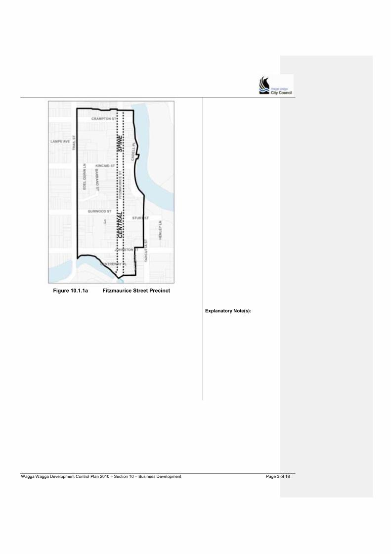
Wagga Wagga Development Control Plan 2010 – Section 10 – Business Development Page 3 of 18
Figure 10.1.1a Fitzmaurice Street Precinct
Explanatory Note(s):
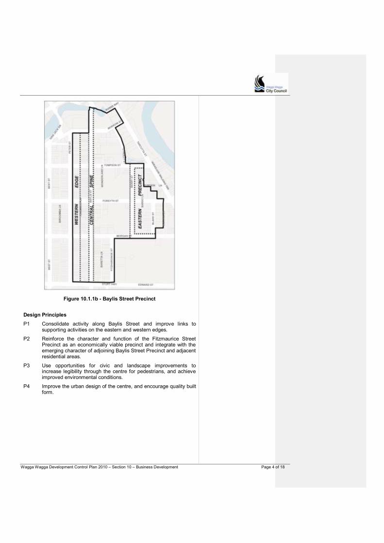
Wagga Wagga Development Control Plan 2010 – Section 10 – Business Development Page 4 of 18
Figure 10.1.1b - Baylis Street Precinct
Design Principles
P1 Consolidate activity along Baylis Street and improve links to supporting activities on the eastern and western edges.
P2 Reinforce the character and function of the Fitzmaurice Street Precinct as an economically viable precinct and integrate with the emerging character of adjoining Baylis Street Precinct and adjacent residential areas.
P3 Use opportunities for civic and landscape improvements to increase legibility through the centre for pedestrians, and achieve improved environmental conditions.
P4 Improve the urban design of the centre, and encourage quality built form.
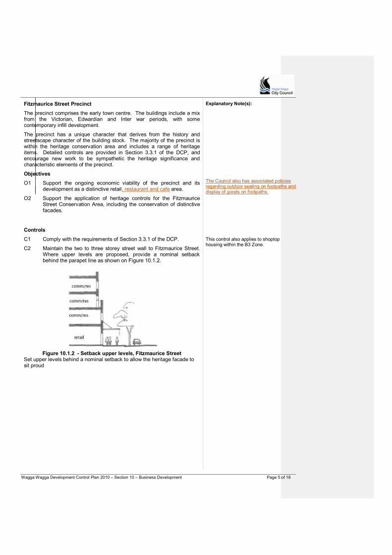
Wagga Wagga Development Control Plan 2010 – Section 10 – Business Development Page 5 of 18
Fitzmaurice Street Precinct
The precinct comprises the early town centre. The buildings include a mix from the Victorian, Edwardian and Inter war periods, with some contemporary infill development.
The precinct has a unique character that derives from the history and streetscape character of the building stock. The majority of the precinct is within the heritage conservation area and includes a range of heritage items. Detailed controls are provided in Section 3.3.1 of the DCP, and encourage new work to be sympathetic the heritage significance and characteristic elements of the precinct.
Objectives
O1 Support the ongoing economic viability of the precinct and its development as a distinctive retail, restaurant and cafe area.
O2 Support the application of heritage controls for the Fitzmaurice Street Conservation Area, including the conservation of distinctive facades.
Explanatory Note(s):
The Council also has associated policies regarding outdoor seating on footpaths and display of goods on footpaths.
Controls
C1 Comply with the requirements of Section 3.3.1 of the DCP.
C2 Maintain the two to three storey street wall to Fitzmaurice Street. Where upper levels are proposed, provide a nominal setback behind the parapet line as shown on Figure 10.1.2.
This control also applies to shoptop housing within the B3 Zone.
Figure 10.1.2 - Setback upper levels, Fitzmaurice Street
Set upper levels behind a nominal setback to allow the heritage facade to sit proud
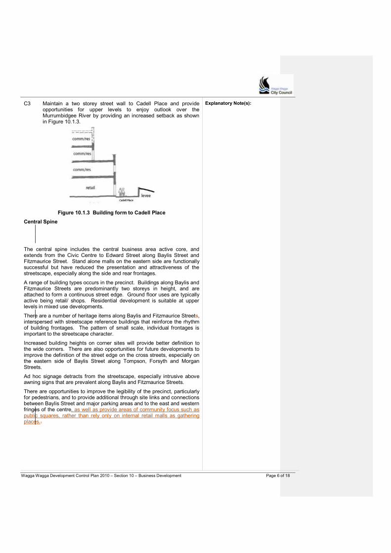
Wagga Wagga Development Control Plan 2010 – Section 10 – Business Development Page 6 of 18
C3 Maintain a two storey street wall to Cadell Place and provide opportunities for upper levels to enjoy outlook over the Murrumbidgee River by providing an increased setback as shown in Figure 10.1.3.
Figure 10.1.3 Building form to Cadell Place
Explanatory Note(s):
Central Spine
The central spine includes the central business area active core, and extends from the Civic Centre to Edward Street along Baylis Street and Fitzmaurice Street. Stand alone malls on the eastern side are functionally successful but have reduced the presentation and attractiveness of the streetscape, especially along the side and rear frontages.
A range of building types occurs in the precinct. Buildings along Baylis and Fitzmaurice Streets are predominantly two storeys in height, and are attached to form a continuous street edge. Ground floor uses are typically active being retail/ shops. Residential development is suitable at upper levels in mixed use developments.
There are a number of heritage items along Baylis and Fitzmaurice Streets, interspersed with streetscape reference buildings that reinforce the rhythm of building frontages. The pattern of small scale, individual frontages is important to the streetscape character.
Increased building heights on corner sites will provide better definition to the wide corners. There are also opportunities for future developments to improve the definition of the street edge on the cross streets, especially on the eastern side of Baylis Street along Tompson, Forsyth and Morgan Streets.
Ad hoc signage detracts from the streetscape, especially intrusive above awning signs that are prevalent along Baylis and Fitzmaurice Streets.
There are opportunities to improve the legibility of the precinct, particularly for pedestrians, and to provide additional through site links and connections between Baylis Street and major parking areas and to the east and western fringes of the centre, as well as provide areas of community focus such as public squares, rather than rely only on internal retail malls as gathering places..

Wagga Wagga Development Control Plan 2010 – Section 10 – Business Development Page 7 of 18
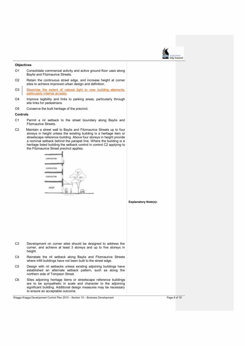
Wagga Wagga Development Control Plan 2010 – Section 10 – Business Development Page 8 of 18
Objectives
O1 Consolidate commercial activity and active ground floor uses along Baylis and Fitzmaurice Streets.
O2 Retain the continuous street edge, and increase height at corner sites to achieve improved urban design and definition.
O3 Maximise the extent of natural light to new building elements, particularly internal arcades
O4 Improve legibility and links to parking areas, particularly through site links for pedestrians.
O5 Conserve the built heritage of the precinct.
Controls
C1 Permit a nil setback to the street boundary along Baylis and Fitzmaurice Streets.
C2 Maintain a street wall to Baylis and Fitzmaurice Streets up to four storeys in height unless the existing building is a heritage item or streetscape reference building. Above four storeys in height provide a nominal setback behind the parapet line. Where the building is a heritage listed building the setback control in control C2 applying to the Fitzmaurice Street precinct applies.
Explanatory Note(s):
C3 Development on corner sites should be designed to address the corner, and achieve at least 3 storeys and up to five storeys in height.
C4 Reinstate the nil setback along Baylis and Fitzmaurice Streets where infill buildings have not been built to the street edge.
C5 Design with nil setbacks unless existing adjoining buildings have established an alternate setback pattern, such as along the northern side of Tompson Street.
C6 Sites adjoining heritage items or streetscape reference buildings are to be sympathetic in scale and character to the adjoining significant building. Additional design measures may be necessary to ensure an acceptable outcome.
Wagga Wagga Development Control Plan 2010 – Section 10 – Business Development Page 9 of 18
C7 Retain articulated and active shop fronts windows that continue the traditional rhythm of individual shop fronts where site consolidation is proposed.
C8 Retain and reinstate (where missing) continuous full width awnings along Baylis and Fitzmaurice Streets. Use traditional awning form. Infill awning type should have its fascia at a level consistent with that of adjacent awnings and should be designed to complement the local streetscape. Avoid peaked, bullnosed or other non-traditional forms.
C9 Service structures and mechanical equipment to be suitably treated, screened or incorporated within roof design.
C10 Development on Edward Street „gateway‟ opportunity site in accordance with indicative plan
Council requires permits for all cantilevered awnings, accompanied by certification (for a minimum period of 7 years) by a qualified practicising Civil Engineer.
Eastern precinct
The Berry Street and Blake Street precinct contains a number of under-utilised sites. There are no consistent front setbacks or built patterns, and the streetscape lacks an identifiable character.
The precinct offers considerable opportunities for central business area service uses, offices, mixed use developments, bulky goods premises, hotel accommodation and recreational facilities, clubs and the like. Development along the eastern side of Berry and Blake Streets should be weighted towards the street frontage to reduce potential impacts on the adjoining residential precinct.
There are opportunities to improve connections to the Tarcutta Street East medium density area, and Bolton Park/ the Oasis centre to the south.
Reducing the carriageway of Blake and Berry Streets with centre plantings or similar would significantly improve the precinct‟s character with a much needed greening. Angled parking may be appropriate to increase the on-street parking capacity.
The maximum building height set by the LEP is 25m with a maximum Floor Space Ratio (FSR) of 4:1.
Explanatory Note(s):
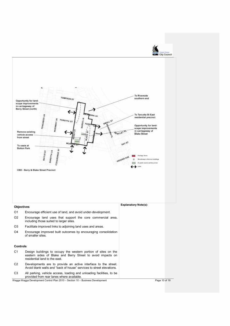
Wagga Wagga Development Control Plan 2010 – Section 10 – Business Development Page 10 of 18
Objectives
O1 Encourage efficient use of land, and avoid under-development.
O2 Encourage land uses that support the core commercial area, including those suited to larger sites.
O3 Facilitate improved links to adjoining land uses and areas.
O4 Encourage improved built outcomes by encouraging consolidation of smaller sites.
Explanatory Note(s):
Controls
C1 Design buildings to occupy the western portion of sites on the eastern sides of Blake and Berry Street to avoid impacts on residential land to the east.
C2 Developments are to provide an active interface to the street. Avoid blank walls and “back of house” services to street elevations.
C3 All parking, vehicle access, loading and unloading facilities, to be provided from rear lanes where available.

Wagga Wagga Development Control Plan 2010 – Section 10 – Business Development Page 11 of 18
C4 No off-street parking in the front setback area.
Western Precinct - Peter Street
The eastern side of Peter Street forms the western edge of the city centre. Buildings are detached, with a number dating from the early twentieth century. Setbacks to the street vary from nil to two to three metres in a reasonably closely built pattern. Full width footpath awnings are isolated and not prevalent in the street.
The precinct has a well established landscape character, with centre road plantings that contribute to a pleasant streetscape. The street trees define the edge of the commercial precinct, and support a positive transition to the adjoining residential precinct. Where buildings have a small setback landscaping is important to maintain the character of the street.
There is potential for the street to support a two to three storey built edge while preserving the existing street character. Developments should retain articulated facades, and avoid blank walls.
The precinct is suited to a mix of service and professional uses such as real estate agents, employment and training uses, service and medical related uses. Large scale developments and significant site consolidation, is not appropriate in this precinct.
Opportunities to increase through site links to Baylis Street, and the legibility of existing links should be addressed by future developments.
Explanatory Note(s):
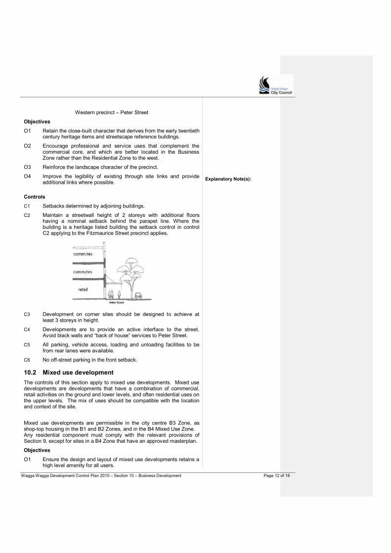
Wagga Wagga Development Control Plan 2010 – Section 10 – Business Development Page 12 of 18
Western precinct – Peter Street
Objectives
O1 Retain the close-built character that derives from the early twentieth century heritage items and streetscape reference buildings.
O2 Encourage professional and service uses that complement the commercial core, and which are better located in the Business Zone rather than the Residential Zone to the west.
O3 Reinforce the landscape character of the precinct.
O4 Improve the legibility of existing through site links and provide additional links where possible.
Explanatory Note(s):
Controls
C1 Setbacks determined by adjoining buildings.
C2 Maintain a streetwall height of 2 storeys with additional floors having a nominal setback behind the parapet line. Where the building is a heritage listed building the setback control in control C2 applying to the Fitzmaurice Street precinct applies.
C3 Development on corner sites should be designed to achieve at least 3 storeys in height.
C4 Developments are to provide an active interface to the street. Avoid black walls and “back of house” services to Peter Street.
C5 All parking, vehicle access, loading and unloading facilities to be from rear lanes were available.
C6 No off-street parking in the front setback.
10.2 Mixed use development
The controls of this section apply to mixed use developments. Mixed use developments are developments that have a combination of commercial, retail activities on the ground and lower levels, and often residential uses on the upper levels. The mix of uses should be compatible with the location and context of the site.
Mixed use developments are permissible in the city centre B3 Zone, as shop-top housing in the B1 and B2 Zones, and in the B4 Mixed Use Zone. Any residential component must comply with the relevant provisions of Section 9, except for sites in a B4 Zone that have an approved masterplan.
Objectives
O1 Ensure the design and layout of mixed use developments retains a high level amenity for all users.
Wagga Wagga Development Control Plan 2010 – Section 10 – Business Development Page 13 of 18
O2 Encourage active street frontages and an opportunity for a mix of uses.
O3 Ensure that the form of mixed use development in the B4 Zone is appropriate to its built context.
O4 Encourage adaptive reuse of existing large-scale buildings in the B4 Zone.
O5 Ensure that development of sites within B4 Zone is based on an urban design based Masterplan.
Controls
C1 All developments on sites and consolidated sites larger than 1 hectare within the B4 zone are required to be in accordance with an urban design based on master plan approved by Council. Controls C2 to C9 will not apply in such instances.
C2 Locate commercial and retail uses at ground level. Any residential component should be on upper level floors.
C3 Provide a ground floor frontage that is compatible with the form, rhythm, scale and character of adjoining developments or the intended future built character for the area. For example, in an area characterised by smaller shop fronts locate larger uses or commercial spaces within the building or on upper levels.
C4 Provide separate entrances to the residential and non-residential components.
C5 On-site parking should be provided either in basement parking levels or otherwise be concealed from view from the façade to the primary street frontage.
C6 Access to basement parking levels is to be from one entry point.
C7 Residential parking areas are to be secure and separate from non-residential parking and servicing areas.
C8 The residential component is required to comply with relevant provisions of Part 9 for solar access, private open space and privacy.
C9 Minimise expanses of blank walls, and use articulation and materials to create visually interesting street elevations.
Explanatory Note(s):
The residential component may also be subject to the provisions of SEPP 65 (Design Quality of Residential Flat Development).
10.3 Local centres
There are a number of neighbourhood and local centres across the Wagga Wagga urban area that are beside or close to residential areas.
Neighbourhood centres (B1 Zone) serve the immediate surrounding neighbourhood. They typically support small scale, convenience and service uses. Local centres (B2 Zone) support a broader range of retail and business activities to serve a wider area. They are often on bus routes or close to medium density areas.
It is important for these centres to integrate with, and complement the adjoining land uses, providing pedestrian friendly access routes, and active shop fronts to the streets.
Specialist studies may be required in relation to noise and traffic impacts.
Objectives
O1 Support the ongoing viability of local centres.
O2 Ensure good integration with adjoining residential areas.
Controls

Wagga Wagga Development Control Plan 2010 – Section 10 – Business Development Page 14 of 18
C1 Design to provide an active address to the adjoining residential precinct – avoid blank and unarticulated walls, consider outdoor dining areas or uses that encourage interaction with the street environment.
C2 Setbacks, building design and location – locate building bulk to ensure acceptable setbacks to any adjoining residential land. A landscaped buffer may be required.
C3 Design and locate signs to minimise light spill to adjoining or nearby residential land.
C4 The location of vehicle entrance and exit points is to minimise disturbance to the functioning of adjoining roads, and avoid directing additional traffic through residential precincts.
C5 Design and location of loading and unloading facilities away from residential properties close to the site and provide adequate screening.
C6 Provide bicycle parking facilities at a rate of 1 bicycle per 200m2of
gross floor area.
C7 Locate services and any mechanical vents or equipment away from residential development.
C8 Hours of operation are generally not to exceed 6am to 9pm daily. However dispensation may be considered for uses licensed to operate beyond those times, based on individual merits.
10.4 Neighbourhood shops
Neighbourhood shops are the traditional local “corner shops” that sell small daily convenience goods such as food, personal care products, and newspapers and the like.
Neighbourhood shops are allowed in residential, business and industrial zones, but must have less than 100m
2 of retail floor space under the LEP.
Explanatory Note(s):
Objectives
O1 Ensure that the design of neighbourhood shops is are compatible with surrounding land uses.
O2 Ensure compatibility with the amenity of adjoining residential development.
Wagga Wagga Development Control Plan 2010 – Section 10 – Business Development Page 15 of 18
Controls
C1 Use good site planning to protect the amenity and outlook of adjoining and nearby residences (as relevant). This may require locating potential noise sources away from sensitive receivers, and screening storage areas and the like.
C2 Outdoor seating can be considered depending on site conditions and context.
C3 Rubbish bins and bike parking areas may be required to be provided.
C4 Hours of operation are not to exceed 6am to 9pm daily.
C5 Adequate waste storage and disposal facilities are to be provided.
C6 Signage is not to impact on the amenity of adjoining residential properties.
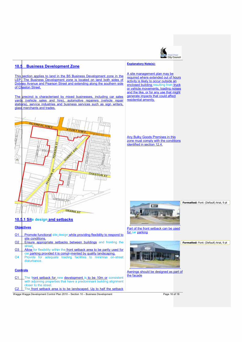
Wagga Wagga Development Control Plan 2010 – Section 10 – Business Development Page 16 of 18
10.5 Business Development Zone
This section applies to land in the B5 Business Development zone in the LEP. The Business Development zone is located on land both sides of Dobney Avenue and Pearson Street and extending along the southern side of Chaston Street.
The precinct is characterised by mixed businesses, including car sales yards (vehicle sales and hire), automotive repairers (vehicle repair stations), service industries and business services such as sign writers, glass merchants and trades.
10.5.1 Site design and setbacks
Objectives O1 Promote functional site design while providing flexibility to respond to
site conditions. O2 Ensure appropriate setbacks between buildings and fronting the
street. O3 Allow for flexibility within the front setback area to be partly used for
car parking provided it is complemented by quality landscaping. O4 Provide for adequate loading facilities to minimise on-street
disturbance.
Controls C1 The front setback for new development is to be 10m or consistent
with adjoining properties that have a predominant building alignment closer to the street.
C2 The front setback area is to be landscaped. Up to half the setback
Explanatory Note(s):
A site management plan may be required where extended out of hours activity is likely to occur outside an enclosed building resulting from truck or vehicle movements, loading noises and the like, or for any use that might generate impacts that could affect residential amenity. Any Bulky Goods Premises in this zone must comply with the conditions identified in section 12.4.
Part of the front setback can be used for car parking
Awnings should be designed as part of the facade
Formatted: Font: (Default) Arial, 9 pt
Formatted: Font: (Default) Arial, 9 pt
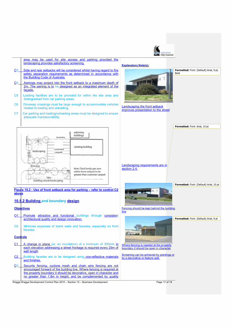
Wagga Wagga Development Control Plan 2010 – Section 10 – Business Development Page 17 of 18
area may be used for site access and parking provided the landscaping provides satisfactory screening.
C3 Side and rear setbacks will be considered whilst having regard to fire
safety separation requirements as determined in accordance with the Building Code of Australia.
C4 Awnings may project into the front setback to a maximum depth of 2m. The awning is to be designed as an integrated element of the façade.
C5 Loading facilities are to be provided for within the site area and distinguished from car parking areas.
C6 Driveway crossings must be large enough to accommodate vehicles related to loading and unloading.
C7 Car parking and loading/unloading areas must be designed to ensure adequate manoeuvrability.
Figure 10.2 - Use of front setback area for parking – refer to control C2 above
10.5.2 Building and boundary design
Objectives O1 Promote attractive and functional buildings through consistent
architectural quality and design innovation. O2 Minimise expanses of blank walls and facades, especially on front
facades. Controls C1 A change in plane (ie. an inundation) of a minimum of 300mm in
each elevation addressing a street frontage is required every 25m of wall length.
C2 Building facades are to be designed using non-reflective materials and finishes.
C3 Security fencing, cyclone mesh and chain wire fencing are not encouraged forward of the building line. Where fencing is required at the property boundary it should be decorative, open in character and no greater than 1.8m in height, and be complemented by quality
Explanatory Note(s):
Landscaping the front setback improves presentation to the street
Landscaping requirements are in section 2.4.
Fencing should be kept behind the building line
Where fencing is needed at the property boundary it should be open in character Screening can be achieved by plantings or by a decorative or feature wall.
Formatted: Font: Arial, 10 pt
Formatted: Font: (Default) Arial, 9 pt,Bold
Formatted: Font: (Default) Arial, 10 pt
Formatted: Font: (Default) Arial, 9 pt
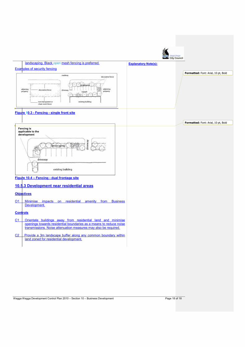
Wagga Wagga Development Control Plan 2010 – Section 10 – Business Development Page 18 of 18
landscaping. Black open mesh fencing is preferred.
Examples of security fencing
Figure 10.3 - Fencing - single front site
Figure 10.4 – Fencing - dual frontage site
10.5.3 Development near residential areas
Objectives O1 Minimise impacts on residential amenity from Business
Development. Controls C1 Orientate buildings away from residential land and minimise
openings towards residential boundaries as a means to reduce noise transmissions. Noise attenuation measures may also be required.
C2 Provide a 3m landscape buffer along any common boundary within
land zoned for residential development.
Explanatory Note(s):
Fencing is applicable to the
development
Formatted: Font: Arial, 10 pt, Bold
Formatted: Font: Arial, 10 pt, Bold
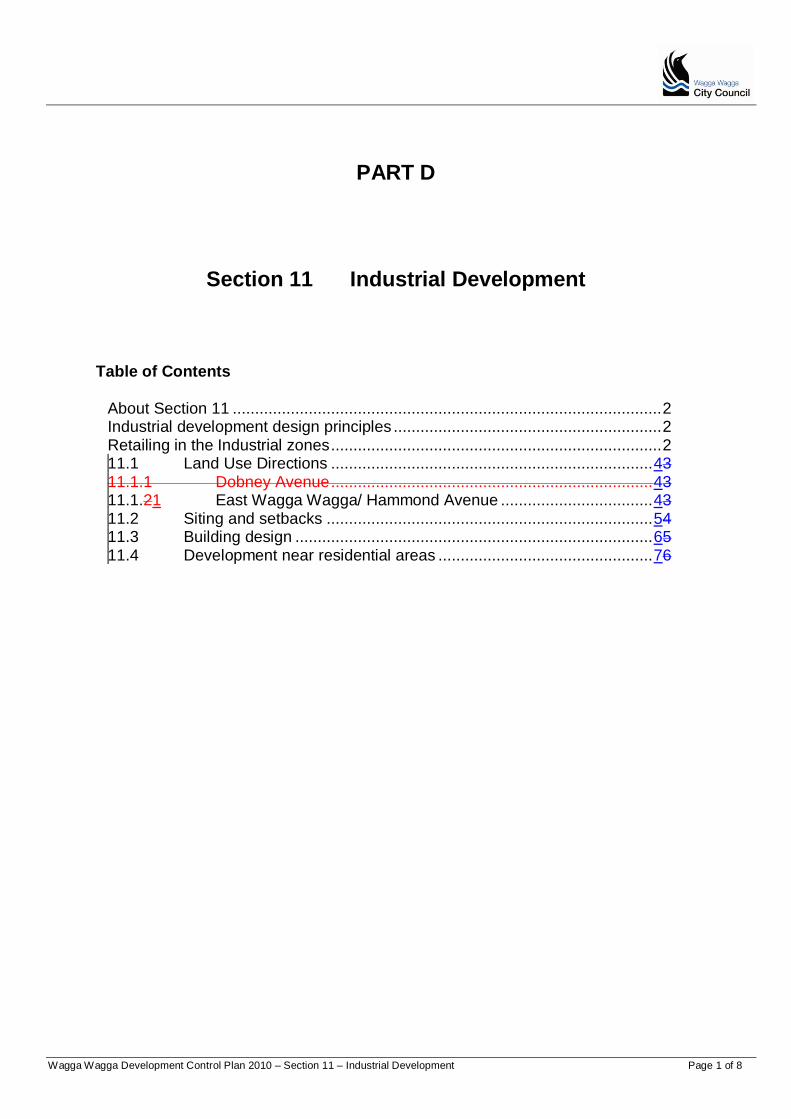
Wagga Wagga Development Control Plan 2010 – Section 11 – Industrial Development Page 1 of 8
PART D
Section 11 Industrial Development
Table of Contents
About Section 11 ................................................................................................ 2
Industrial development design principles ............................................................ 2
Retailing in the Industrial zones .......................................................................... 2
11.1 Land Use Directions ........................................................................ 43
11.1.1 Dobney Avenue ........................................................................ 43
11.1.21 East Wagga Wagga/ Hammond Avenue .................................. 43
11.2 Siting and setbacks ......................................................................... 54
11.3 Building design ................................................................................ 65
11.4 Development near residential areas ................................................ 76

Wagga Wagga Development Control Plan 2010 – Section 11 – Industrial Development Page 2 of 8
About Section 11
Section 11 contains the controls for industrial development. There are two types of industrial zones under the LEP – general industrial IN1 Zone and light industrial IN2 Zone. The LEP defines the land uses that can occur in each zone reflecting the location and zone objectives.
Things to note about the IN1 and IN2 Zones are:
Bulky goods are only permissible in specified locations as determined by the LEP.
Shops and commercial uses can only occur under certain limited conditions – see notes below.
Refer to Section 7 for guidelines on Industrial Subdivision.
Industrial development design principles
P1 Development is to be suited to its site in terms of the nature of the use, relationship to adjoining uses and availability of land for industrial development.
P2 Development should be consistent with the principles of Industrial ecology.
Retailing in the Industrial zones
Generally, shops and retail premises are not permissible in the IN1 or IN2 Zones. However within the industrial zones there are limited opportunities for the following types of premises: Neighbourhood shop Industrial retail outlet or Timber Hardware and building supplies Timber yards Landscaping material supplies Rural supplies Vehicle sales or hire premises Bulky goods premises.
Explanatory Note(s): Refer to Part A requirements that apply to all applications Complying with this DCP The controls in the DCP support the Guiding Principles and Section Objectives. A Development Application mustshould aim to satisfy the Guiding Principles, and the Objectives of the relevant sections. Equal emphasis must be given to both "numeric" and non-numeric controls relevant to a particular development. Where a proposed development has an unacceptable impact on neighbours or the surrounding environment cCompliance with controls will not necessarily guarantee approval of an application. Where a variation is sought to controls, the application must document the reasons and extent of the variation, and how the variation meets the Guiding Principles and Section Objectives for the consideration of the Council.
Bulky goods retailing can only occur in business zones and the specific locations identified in Schedule 1 of the LEP. It is not permitted in the Industrial zones. Controls for bulky goods premises are in Section 12.4 of the DCP.
Any application that involves retail space in the IN1 or IN2 Zones must be within one of those categories. A brief description is provided below. Refer to the LEP for full definitions. Neighbourhood shop A neighbourhood shop sells daily convenience goods like food, personal care products and newspapers. Neighbourhood shops typically cater for day to day needs and can include ancillary services like post, bank or dry cleaning services. Maximum retail floor area - 100m2 [the LEP 2010 Clause 5.4(7)]. Industrial retail outlet Industrial retail outlets are used in conjunction with an industry but not in conjunction with a warehouse or distribution centre. The industrial retail outlet must be on the same land as the industry and will display or offer goods for sale that have been manufactured on the site. The maximum retail floor area is 10 percent of the combined gross floor area of the industrial retail outlet and the industrial premises or 400m2 (whichever is the lesser) - LEP Clause 5.4(4).
Timber Hardware and building supplies Timber Hardware and building supply premises can display, sell (wholesale or
Wagga Wagga Development Control Plan 2010 – Section 11 – Industrial Development Page 3 of 8
retail) or hire goods and materials that are used in the construction and maintenance of buildings. Timber yards A timber yard can sell sawn, dressed or treated timber, wood fibre boards or similar timber products as well as materials used in conjunction with the use and treatment of timber. Landscaping material supplies Landscaping material supplies premises can store and sell landscaping supplies such as soil, gravel, sand, rock and the like. Rural supplies Rural supplies are a type of retail premises that can display, sell or hire goods or materials used in farming and primary industry production. Vehicle sales or hire premises Vehicle sales premises can display, sell or hire motor vehicles, boats, agricultural machinery and the like, wheather or not accessories are sold or displayed there. Bulky good premises Bulky goods premises can display, sell or hire goods that typically require a large area for handling, display or storage and direct vehicular access for loading or unloading after purchase or hire.
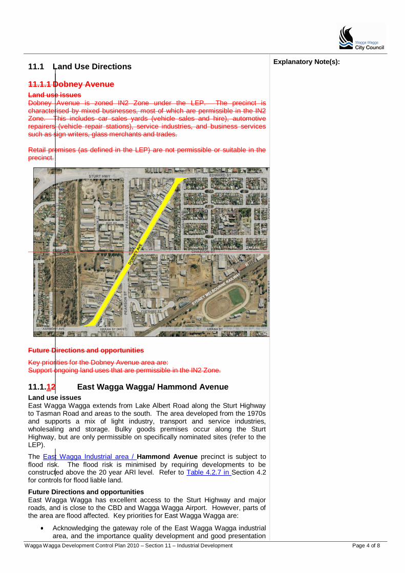
Wagga Wagga Development Control Plan 2010 – Section 11 – Industrial Development Page 4 of 8
11.1 Land Use Directions
11.1.1 Dobney Avenue
Land use issues Dobney Avenue is zoned IN2 Zone under the LEP. The precinct is characterised by mixed businesses, most of which are permissible in the IN2 Zone. This includes car sales yards (vehicle sales and hire), automotive repairers (vehicle repair stations), service industries, and business services such as sign writers, glass merchants and trades. Retail premises (as defined in the LEP) are not permissible or suitable in the precinct.
Explanatory Note(s):
Future Directions and opportunities
Key priorities for the Dobney Avenue area are: Support ongoing land uses that are permissible in the IN2 Zone.
11.1.12 East Wagga Wagga/ Hammond Avenue
Land use issues East Wagga Wagga extends from Lake Albert Road along the Sturt Highway to Tasman Road and areas to the south. The area developed from the 1970s and supports a mix of light industry, transport and service industries, wholesaling and storage. Bulky goods premises occur along the Sturt Highway, but are only permissible on specifically nominated sites (refer to the LEP).
The East Wagga Industrial area / Hammond Avenue precinct is subject to flood risk. The flood risk is minimised by requiring developments to be constructed above the 20 year ARI level. Refer to Table 4.2.7 in Section 4.2 for controls for flood liable land.
Future Directions and opportunities East Wagga Wagga has excellent access to the Sturt Highway and major roads, and is close to the CBD and Wagga Wagga Airport. However, parts of the area are flood affected. Key priorities for East Wagga Wagga are:
Acknowledging the gateway role of the East Wagga Wagga industrial area, and the importance quality development and good presentation
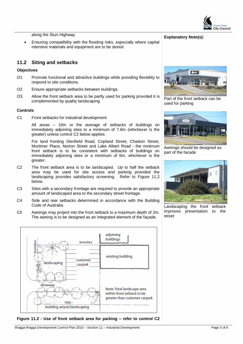
Wagga Wagga Development Control Plan 2010 – Section 11 – Industrial Development Page 5 of 8
along the Sturt Highway
Ensuring compatibility with the flooding risks, especially where capital intensive materials and equipment are to be stored.
Explanatory Note(s):
11.2 Siting and setbacks
Objectives
O1 Promote functional and attractive buildings while providing flexibility to respond to site conditions.
O2 Ensure appropriate setbacks between buildings.
O3 Allow the front setback area to be partly used for parking provided it is complemented by quality landscaping.
Part of the front setback can be used for parking
Controls
C1 Front setbacks for industrial development:
All areas – 10m or the average of setbacks of buildings on immediately adjoining sites to a minimum of 7.6m (whichever is the greater) unless control C2 below applies.
For land fronting Glenfield Road, Copland Street, Chaston Street, Mortimer Place, Norton Street and Lake Albert Road - the minimum front setback is to be consistent with setbacks of buildings on immediately adjoining sites or a minimum of 6m, whichever is the greater.
C2 The front setback area is to be landscaped. Up to half the setback area may be used for site access and parking provided the landscaping provides satisfactory screening. Refer to Figure 11.2 below.
C3 Sites with a secondary frontage are required to provide an appropriate amount of landscaped area to the secondary street frontage.
C4 Side and rear setbacks determined in accordance with the Building Code of Australia.
C5 Awnings may project into the front setback to a maximum depth of 2m. The awning is to be designed as an integrated element of the façade.
Awnings should be designed as part of the facade
Landscaping the front setback improves presentation to the street
Figure 11.2 - Use of front setback area for parking – refer to control C2

Wagga Wagga Development Control Plan 2010 – Section 11 – Industrial Development Page 6 of 8
above
11.3 Building design
Objectives
Explanatory Note(s):
O1 Promote consistency architectural quality and design innovation.
O2 Promote attractive and functional industrial development within quality, designed landscapes.
Building design should be functional and attractive.
Landscaping requirements are at Section 2.4.
Controls
C1 Contemporary architecture and design innovation is encouraged.
C2 Minimise expanses of blank walls and blank facades, especially on front facades. A change in plane in each elevation addressing a street frontage is required every 25m of wall length.
C3 Use non-reflective materials and finishes.
C4 Combine materials and finishes to achieve innovative design outcomes.
C5 Full sheet metal fencing is not encouraged forward of the building line. Where fencing is required at the property boundary or in front of the building line, it should be open in character and a maximum of 1.8m in height, and be complemented by quality landscaping. Black mesh fencing is the preferred form of open fencing.
Examples of security fencing
Figure 11.3 - Fencing - single front site
Fencing should be kept behind the building line
Where fencing is needed at the property boundary it should be open in character Screening can be achieved by plantings or by a decorative or feature wall.
fencing
fencing
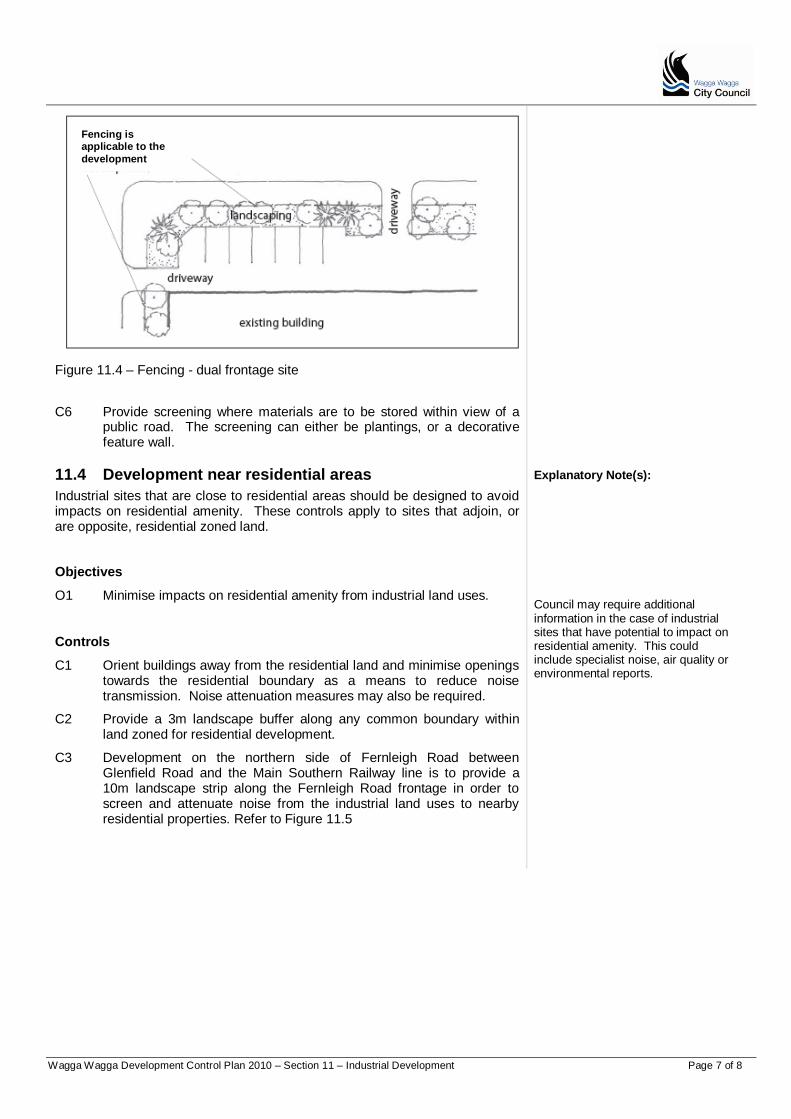
Wagga Wagga Development Control Plan 2010 – Section 11 – Industrial Development Page 7 of 8
Figure 11.4 – Fencing - dual frontage site
C6 Provide screening where materials are to be stored within view of a public road. The screening can either be plantings, or a decorative feature wall.
11.4 Development near residential areas
Industrial sites that are close to residential areas should be designed to avoid impacts on residential amenity. These controls apply to sites that adjoin, or are opposite, residential zoned land.
Explanatory Note(s):
Objectives
O1 Minimise impacts on residential amenity from industrial land uses.
Controls
C1 Orient buildings away from the residential land and minimise openings towards the residential boundary as a means to reduce noise transmission. Noise attenuation measures may also be required.
C2 Provide a 3m landscape buffer along any common boundary within land zoned for residential development.
C3 Development on the northern side of Fernleigh Road between Glenfield Road and the Main Southern Railway line is to provide a 10m landscape strip along the Fernleigh Road frontage in order to screen and attenuate noise from the industrial land uses to nearby residential properties. Refer to Figure 11.5
Council may require additional information in the case of industrial sites that have potential to impact on residential amenity. This could include specialist noise, air quality or environmental reports.
Fencing is applicable to the
development
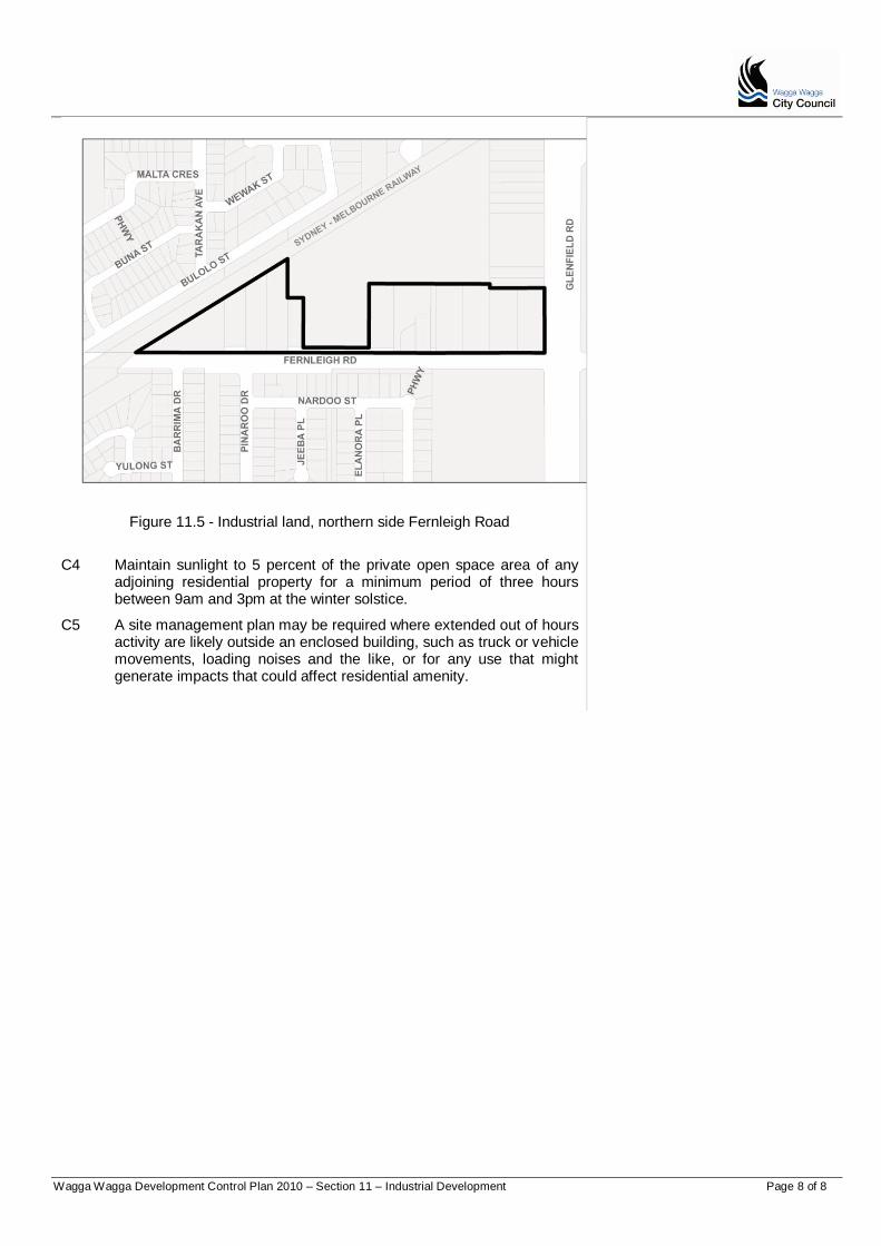
Wagga Wagga Development Control Plan 2010 – Section 11 – Industrial Development Page 8 of 8
Figure 11.5 - Industrial land, northern side Fernleigh Road
C4 Maintain sunlight to 5 percent of the private open space area of any adjoining residential property for a minimum period of three hours between 9am and 3pm at the winter solstice.
C5 A site management plan may be required where extended out of hours activity are likely outside an enclosed building, such as truck or vehicle movements, loading noises and the like, or for any use that might generate impacts that could affect residential amenity.
Wagga Wagga Development Control Plan 2010 – Section 12 - Specific Uses and Developments Page 1 of 8
PART D
Section 12 Specific Uses and Developments
Table of Contents About Section 12 ........................................................................................................ 212.1 Wagga Wagga Airport ........................................................................... 212.2 Gregadoo Waste Facility ....................................................................... 212.3 Development on land zoned RE1 Public Recreation ............................. 312.4 Bulky Goods Premises .......................................................................... 312.5 Childcare Centres ................................................................................. 412.6 Health Consulting Rooms and Medical Centres .................................... 512.7 Sex Services Premises and Restricted Premises ................................. 7
Wagga Wagga Development Control Plan 2010 – Section 12 - Specific Uses and Developments Page 2 of 8
About Section 12
Section 12 contains controls that apply to site specific uses and particular developments throughout the Wagga Wagga local government area.
Explanatory Note(s):
Part A requirements that apply to all Development Applications.
12.1 Wagga Wagga Airport
Objectives
O1 Ensure appropriate development in the vicinity of Wagga Wagga Airport.
O2 Ensure that buildings in the vicinity of the airport have suitable noise attenuation.
Council may refer applications in the vicinity of Wagga Wagga Airport to the Civil Aviation Safety Authority.
Controls
C1 Development within the vicinity of Wagga Wagga Airport is not to exceed the maximum height limits specified on the Obstacle Limitation Surfaces Plan.
C2 Applications where a proposed development exceeds the height limits in the Obstacle Limitation Surfaces Plan are required to be referred to the Civil Aviation Safety Authority. Any comments provided by the Civil Aviation Safety Authority within 28 days of the referral will be considered in the assessment of the application.
C3 Development in the vicinity of Wagga Wagga Airport is to incorporate noise attenuation appropriate to the level of noise exposure as indicated on the Wagga Wagga Airport Australian Noise Exposure Forecast Map 2009 (ANEF) as relevant to the proposed use.
C4 The following matters are to be considered in determining an application for land within the ANEF contours shown on the ANEF Map:
a. Relevant guidelines contained in Australian Standard AS2021-2000 (Acoustics- Aircraft Noise) and;
b. The extent to which the frequency of aircraft operation warrants preventative noise protection measures.
12.2 Gregadoo Waste Facility
This section applies to land within 700m of the perimeter of the Gregadoo Waste Facility. The facility is the primary waste disposal centre in the local government area of Wagga Wagga. The facility operates seven days a week, and can be required to operate outside normal hours (up to 24 hours a day).
These controls are intended to ensure that land uses and developments near the facility are designed and sited to minimise potential impacts arising from its operations. This includes, dust, odour, noise and litter.
Objectives
O1 Provide for the ongoing operation of the Gregadoo Waste Facility.
Complying with this DCP
The controls in the DCP support the Guiding Principles and Section Objectives. A Development Application must satisfy the Guiding Principles, and the Objectives of the relevant sections. Equal emphasis must be given to both "numeric" and non-numeric controls relevant to a particular development. Compliance with controls will not necessarily guarantee approval of an application. Where a variation is sought, the application must document the reasons and extent of the variation, and how the variation meets the Guiding Principles and Section Objectives for the consideration of the Council. The Obstacle Limitation Surfaces Plan and Australian Noise Exposure Forecast Map 2009 can be viewed at Council’s website at www.wagga.nsw.gov.au.
O2 Ensure the suitability of uses in close proximity to the waste facility.
Controls
C1 Any development within 700m of the Gregadoo Waste Facility is to demonstrate that the proposal will not adversely impact on the longer term operation of the waste facility.

Wagga Wagga Development Control Plan 2010 – Section 12 - Specific Uses and Developments Page 3 of 8
C2 Incorporate design measures to avoid any likely adverse impacts from the waste facility on adjoining properties.
Explanatory Note(s):
12.3 Development on land zoned for public recreation (RE1)
This section applies to developments proposed on land zoned for public recreation.
Objectives
O1 Protect and enhance areas of public recreation.
O2 Ensure proposals adequately address potential impacts on public recreation areas including existing and likely future needs of the community.
Controls
C1 Applications for development in public reserves and parks are to demonstrate that there is a reasonable need for the proposed use or facility.
C2 Developments are to consider the need for public recreation areas to serve the immediately adjoining area, taking into consideration any changing demographics of the area.
C3 Design to complement the public recreation area and adjoining land uses.
C4 All works to be consistent with any Plan of Management or public recreation strategy.
12.4 Bulky Goods Premises
Under the LEP, Bulky Goods Premises are permitted in the business zones and on particular sites, but not in industrial zones.
Bulky goods products typically require large showroom space for display, and handling by fork lift loader. Bulky goods can include carry away finished and semi-complete furniture and furnishings, but not everyday needs such as clothing, small household items, fresh food or produce or office supplies.
Objectives
O1 Ensure that the floor space of Bulky Goods Premises is substantially used for the sale of larger items.
O2 Ensure safe and efficient access, site planning and layout.
Controls
C1 Bulky Goods Premises are not to sell “everyday needs” such as clothing or small household items, fresh food or produce, or office supplies.
C2 At least 80 percent of the gross floor area is to be dedicated to large items.
C3 A coordinated sign and access strategy is required for sites that propose multiple tenancies. The strategy is to make provision for a centralised sign containing details of the businesses located on the site, directional signs for the safe and efficient operation of the site, and details of the size and location of individual tenancy signs.
C4 Sites with multiple tenancies are to provide safe access routes for
The design of all Bulky Goods Premises is to be in accordance with the controls in section 11.3.
vanieperenh
Highlight

Wagga Wagga Development Control Plan 2010 – Section 12 - Specific Uses and Developments Page 4 of 8
pedestrians, responding to likely or anticipated desire lines, avoiding conflict with vehicular movement.
12.5 Childcare Centres
Childcare Centres are permissible in a number of zones, including residential areas. Care is required to ensure adequate provision for drop off and parking facilities, and to protect the amenity of adjoining noise sensitive land uses. Corner sites often allow good access.
Outdoor play areas should be adequately shaded in accordance with Shade for Child Care Centre Services guidelines published by the NSW Cancer Council.
Explanatory Note(s):
Objectives
O1 Encourage child care centres to be located on corner sites and sites parking and access to the centre can be easily managed.
O2 Protect the amenity of adjoining land uses through good site planning, landscaping and layout.
O3 Enhance the streetscape and provide a visually attractive buffer between the street and building/ car park.
O4 Provide children with learning and educational opportunities through landscaping initiatives such as flower beds and vegetable gardens.
Controls
C1 Provide adequate space to allow for drop off and parking requirements within the development site.
C2 Design and locate set down, pick up and parking areas to be visible from the road but to maintain the amenity of adjoining properties.
C3 The front setback is to include a 2m landscape strip. Landscape buffer areas may be required to side boundaries.
C4 Design and locate outdoor activity areas to maximise the natural site features, including climate considerations such as avoiding afternoon sun but take advantage of cooling breezes in summer. All playgrounds must be capable of supervision at all times.
C5 Outdoor play areas are to be fenced on all sides. The fencing is to be at least 1.8m in height, and to be equipped with child proof self locking mechanisms. The fence should be designed to prevent children scaling or crawling under.
C6 The outdoor play area is to include an undercover space that is large enough for use during wet weather and to provide protection from the sun.
C7 Design outdoor play areas to include a range of opportunities for developmental play.
C8 Landscaping, mounding and fencing treatments may be required where there is potential for adverse amenity impacts to adjoining properties. This could include using landscaping to contain outdoor play areas or lapped metal or masonry fencing.
C9 Locate play equipment such as cubby houses, trampolines and slides not to overlook neighbours properties. Shade structures should not be located where they will be elevated in relation to boundary fences where they could cause visual or shadow impacts.
C10 Use vegetation that is non-allergenic and sensitive to water restrictions.
A landscape plan may be required with the application. Refer to requirements at Section 2.4 of the Guide.
Wagga Wagga Development Control Plan 2010 – Section 12 - Specific Uses and Developments Page 5 of 8
12.6 Health Consulting Rooms and Medical Centres
The controls of this section apply to health consulting rooms and medical centres proposed in residential zones.
Health Consulting Rooms operate from residential premises, and are permissible in the R1 and R3 Zone. The LEP limits Health Consulting Rooms to three health care professionals practising in a partnership.
Explanatory Note(s):
Medical Centres are a more intensive use than health consulting rooms, and provide a range of health services to out-patients. Medical centres are permissible in the R3 Zone, but are better suited to the business zones.
Proliferation of Health Consulting Rooms, particularly on the fringe of the city centre, has led to competition for use of existing houses, and loss of amenity from parking, access and poor landscaping outcomes. To avoid further loss of amenity, health consulting rooms are preferred on corner sites, and sites with rear lane access.
Health Consulting Rooms and Medical Centres in residential locations are to maintain the residential character. To minimise amenity impacts, particularly from parking requirements, Health Consulting Rooms that provide for more than two health care professionals are subject to additional controls.
Health Consulting Rooms are permissible in the R1 and R3 Zones Medical Centres are permissible in the R3, B1, B2 and B3 Zones. Applications for Health Consulting Rooms and Medical Centres are to include a landscape plan.
Objectives
O1 For preference health consulting rooms should be located on corner sites and sites with rear lane access.
O2 Retain the predominantly residential character of sites used for Health Consulting Rooms and Medical Centres in residential locations.
O3 Discourage larger Health Consulting Rooms and Medical Centres on sites that cannot support required parking or access.
Controls
C1 Locate health consulting rooms on corner sites and sites with rear lane access.
C2 Comply with site cover and landscaped requirements as they apply to residential development.
C3 Health Consulting Rooms are to occupy existing premises without the need for significant alterations or additions, especially where more than two health care professionals are proposed to practise from the premises.
C4 Alterations and additions are not to compromise the residential character of the existing building or streetscape.
C5 For sites fronting rear lanes, retain fencing along part of the rear boundary, or use a combination of landscaping, different paving materials or other devices in a 0.5m setback area to retain delineation of the rear boundary line. Use landscaping, fencing or a change of surface materials to delineate the rear boundary. A setback of 0.5m may be required.
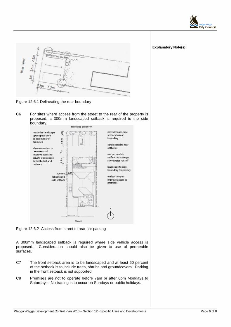
Wagga Wagga Development Control Plan 2010 – Section 12 - Specific Uses and Developments Page 6 of 8
Explanatory Note(s):
Figure 12.6.1 Delineating the rear boundary
C6 For sites where access from the street to the rear of the property is proposed, a 300mm landscaped setback is required to the side boundary.
Figure 12.6.2 Access from street to rear car parking
A 300mm landscaped setback is required where side vehicle access is proposed. Consideration should also be given to use of permeable surfaces.
C7 The front setback area is to be landscaped and at least 60 percent of the setback is to include trees, shrubs and groundcovers. Parking in the front setback is not supported.
C8 Premises are not to operate before 7am or after 6pm Mondays to Saturdays. No trading is to occur on Sundays or public holidays.

Wagga Wagga Development Control Plan 2010 – Section 12 - Specific Uses and Developments Page 7 of 8
12.7 Sex Services Premises and Restricted Premises
The controls of this section apply to Sex Services Premises (brothels) and Restricted Premises. The LEP permits Sex Services Premises in the B3, IN1 and IN2 Zones. Restricted Premises are permitted in IN1 and IN2 Zones.
Sex Services Premises and Restricted Premises require sensitivity to minimise disturbance to surrounding land uses, and avoid detrimental amenity impacts on the locality.
Explanatory Note(s):
Objectives
O1 Ensure Sex Services Premises and Restricted Premises are suitably located, and discrete in presentation.
O2 Ensure Sex Services Premises and Restricted Premises are located at a reasonable distance from other sensitive land uses.
O3 Avoid adverse impacts on surrounding land uses and the amenity of the locality in which they are located.
Controls
C1 Restricted Premises are to be at first floor level where proposed to be located in the B3 Zone.
C2 The entrance to a Sex Services Premises is to be discrete and unobtrusive, with no more than one business identification sign that does not have any sexually explicit images, language or objects.
C3 The entrance to any Restricted Premises is to be at least 400m from the entrance to any child care centre, community facility, educational establishment, hospital or place of public worship.
C4 The entrance to any Sex Services Premises is to be at least 150m from the entrance to a dwelling on residential zoned land, 200m from the entrance to any childcare centre, community facility, educational establishment, hospital or place or public worship.
C5 Sex Services Premises are to include an internal reception/waiting area of appropriate size to discourage loitering outside the premises.
C6 Sex Services Premises are required to comply with any relevant safety and environmental health standards.

Wagga Wagga Development Control Plan 2010 – Section 12 - Specific Uses and Developments Page 8 of 8
Wagga Wagga Development Control Plan 2010 - Section 15 - Lloyd Urban Release Area -Page 1
Part E
Section 15 - Lloyd Urban Release Area

Wagga Wagga Development Control Plan 2010 - Section 15 - Lloyd Urban Release Area Page 2
About the Lloyd Urban Release Area
This section of the WWDCP applies to the Lloyd Urban Release Area (Lloyd). Lloyd is identified as an urban release area under clause 6.3 of the WWLEP 2010. The LEP permits residential (and some limited commercial) development to support the future growth of the city. The development footprint of the proposed Lloyd subdivision is situated within a catchment previously identified as affected by salinity and flagged as a potential groundwater recharge site by NSW Department of Environment, Climate Change and Water (DECCW). The Wagga Wagga Salinity Steering Committee required assurance that urban development at Lloyd would not exacerbate existing salinity issues. This Section includes provisions resulting from intensive investigation undertaken to determine the risk to urban salinity associated with the proposed residential development of Lloyd (Salinity Risk and Mitigation Assessment: Lloyd Subdivision Wagga Wagga NSW and Summary of recommendations: Lloyd Salinity Risk Assessment and Recommendations. Prepared by E.A Systems Pty Ltd. Wagga Wagga NSW).
Salinity Study (Salinity Risk and Mitigation Assessment: Lloyd Subdivision Wagga Wagga NSW and Summary of recommendations: Lloyd Salinity Risk Assessment and Recommendations. Both by E.A Systems Pty Ltd. Wagga Wagga NSW). The Salinity Risk and Mitigation Assessment study has formed the development controls that apply in Lloyd. The objectives of the salinity investigation were to:
Determine if groundwater recharge under the proposed residential development could be less than under current agricultural land use at Lloyd; and
Determine the conditions (development controls) upon which recharge below current levels could be achieved and recommend a process for development which enabled the management of any risk.
An intensive soil survey was conducted, from which groundwater recharge rates were predicted for each of the various land uses proposed (Residential, Native Conservation, Existing Agricultural). Recharge rates were applied to potential subdivision layouts to enable comparison between predicted pre and post development groundwater recharge.
The study predicted that with appropriate design of the sub-division, residential development could be achieved with groundwater recharge rates less than or equal to the current agricultural state (recharge compliance). On this basis urban salinity in Wagga Wagga is not expected to be exacerbated as a result of the development of Lloyd, provided that a number of recommendations are incorporated into the appropriate planning instruments. These recommendations are detailed in full in E.A. Systems “Summary of Recommendations” document and form an integral basis of the controls in this DCP.
The area depicted as Stages 1 and 2 in the EA Systems Salinty Study (see Appendices) shows that only 50% of the land area is deemed to be safe for initial development with respect to avoiding urban salinity impacts. Stages one and two of the proposed four residential land release areas, have been zoned under the WWLEP 2010, for release.
All applications are required to comply with the requirements of Part A of the DCP. In particular, applications are to be consistent with the Guiding Principles at Section 1.5 within Part A.
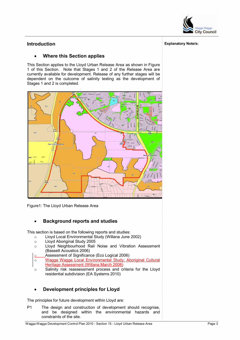
Wagga Wagga Development Control Plan 2010 - Section 15 - Lloyd Urban Release Area Page 3
Introduction Explanatory Note/s:
Where this Section applies
This Section applies to the Lloyd Urban Release Area as shown in Figure 1 of this Section. Note that Stages 1 and 2 of the Release Area are currently available for development. Release of any further stages will be dependent on the outcome of salinity testing as the development of Stages 1 and 2 is completed.
Figure1: The Lloyd Urban Release Area
Background reports and studies
This section is based on the following reports and studies:
o Lloyd Local Environmental Study (Willana June 2002) o Lloyd Aboriginal Study 2005 o Lloyd Neighbourhood Rail Noise and Vibration Assessment
(Bassett Acoustics 2006) o Assessment of Significance (Eco Logical 2006) o Wagga Wagga Local Environmental Study: Aboriginal Cultural
Heritage Assessment (Willana March 2008) o Salinity risk reassessment process and criteria for the Lloyd
residential subdivision (EA Systems 2010)
Development principles for Lloyd
The principles for future development within Lloyd are:
P1 The design and construction of development should recognise, and be designed within the environmental hazards and constraints of the site.

Wagga Wagga Development Control Plan 2010 - Section 15 - Lloyd Urban Release Area Page 4
P2 Developments should minimise risks from salt damage and should not exacerbate the potential for increased salinity through appropriate constructions methods, planting and other appropriate measures.
Explanatory Note/s:
Structure of this Section
This Section is divided into 10 sub-sections. Introduction and includes the administrative details, the Lloyd design principles and other background information. Lodging a Development Application provides information on submitting a Development Application. Features of the Area outlines the major features of the site, including the importance of the local topography and landscape character and an overview of the desired distribution of land uses within the urban release area. Infrastructure Planning contains the controls for infrastructure servicing and staging of development. Environmental Conservation, Biodiversity and Natural Resource Management contains the controls for environmental conservation, biodiversity and natural resource management. This includes controls for development in the biocertified area, salinity and bushfire management. Aboriginal Heritage provides controls for Aboriginal Heritage and the Wiradjuri Walking track. Residential Development contains the controls for residential development within Lloyd. Large Lot Residential and Rural Residential Development contains controls for large lot residential or rural residential development. This section applies to land zoned R5. Development in the Lloyd Business Centre contains the controls for the local business centre in Lloyd.
Lodging a Development Application
Applications are to, and be generally in accordance with, any endorsed development masterplan.
Land at Lloyd is one of the Urban areas that have received Biocertification under the WWLEP 2010. This means that any development requiring consent under Part 4 of the EPA Act or any activity under Part 5 of the EPA Act not requiring consent, is taken to be a development or an activity that is unlikely to significantly affect threatened species, populations, ecological communities or their habitats and can be determined without requirement for further biodiversity assessment
Note: The Lloyd Urban Release Area biocertification covers the area outlined in Figure 1.

Wagga Wagga Development Control Plan 2010 - Section 15 - Lloyd Urban Release Area Page 5
.
Features of the Area
The natural topography and environmental characteristics within Lloyd are important and will influence future development in the area. This section provides an overview of these characteristics and features.
Explanatory Note/s:
Topography and landscape character
Lloyd‟s hilltops and ridges provide extensive regional views over the City and countryside. The site‟s elevation, the moderate slopes to high ridge tops and absence of obstructions such as dense vegetation or built structures, result in the majority of the site having access to significant views. Hilltops to the north offer regional views to the north east and west that include the City; the surrounding countryside and hillscapes to the north of Wagga Wagga. Views of moderate to high significance are obtained looking south from these hilltops and take in the ridges, valley and hilltops of the site itself. Views of a high significance are gained looking out of the site from the eastern ridges and hilltops. Views from the northern midslope which rises from Red Hill Road (approximately 50 - 100m below the ridge) are of a moderate significance and take in the city. The midslopes beneath the eastern ridges and hills offer moderate views of local landforms over the railway line to the west. Much of the central valley has only local views of the ridges and hilltops within the site, but offers an opportunity to create a unique local visual catchment. These local views are of “moderate significance”. The lower land along the northern boundary has minimal views of significance. The north-most land may currently overlook the Red Hill Road Corridor, but would easily lose views with the imposition of structures or landscaping. There are opportunities to create vistas down streets on these lower slopes. This should be encouraged by a predominantly north-south street layout in future plans and subdivision for the undulating land in the north.
Objectives
O1 Protect the landscape character.
O2 Encourage subdivision and development to create vistas on the lower slopes where possible.
Controls
C1. Use subdivision design and layout to create vistas where possible and maximise views out from Lloyd, especially on the lower slopes and northern sections of the area, through a predominantly north-south street layout.
Infrastructure Planning

Wagga Wagga Development Control Plan 2010 - Section 15 - Lloyd Urban Release Area Page 6
This section provides details of servicing requirements (electricity, gas, water, sewer and communications) and staging of development. Planning for the delivery of services to new developments is essential for new urban areas. Servicing plans must consider topographical constraints to achieve appropriate complementary subdivision design.
Objectives
O1 Ensure the efficient and cost effective provision of services.
Controls C1. Subdivision can only be considered where there are appropriate
arrangements for servicing (electricity, gas, water, sewer and communications). The developer shall be responsible for providing reticulated mains sewer supply to allotments, including associated pump stations, to the satisfaction of Council. A sewer plan is included as part of this DCP.
C2. Detailed sewer design plans for each stage of subdivision must be submitted with the development application for that stage of subdivision.
C3. Development is not permitted over the utility corridor that accommodates the water supply main.
Note: Refer to Council‟s Engineering Guidelines for Subdivision and Development for additional detailed requirements.
C4. All Sewerage and Drainage provision should be installed in
accordance with Appendix A of Part 2 “Service Areas” of the City of Wagga Wagga Development Servicing Plan for Sewerage 2007 and;
Note:
1. The map Appendix A included in Part 2 Service Area of the City Of Wagga Wagga Development Servicing Plan (DSP) for Sewerage 2007, covers the Lloyd Urban Release Area
2. The map Urban East of Willians & Urban West of Willians DSP Boundaries Appendix C included in Part 2 Areas of land to which this Policy applies of the City of Wagga Wagga Development Servicing Plan (DSP) for Drainage 2007, covers the Lloyd Urban Release Area.
C5. The developer shall provide reticulated water supply to all
allotments in accordance with the requirements of the service authority. The developer shall be responsible for meeting the cost of internal water reticulation mains and extension of existing mains where necessary.
C6. Reticulated water supply is restricted to below the 280 metre AHD contour.
C7. The developer will be responsible for extending water supply trunk mains to enable service of areas between the 235 and 280 metre contours. In particular, this applies to Precinct 1.
C8. The developer is required to liaise with Riverina Water to ensure development proceeds in an orderly fashion that allows connection to existing water infrastructure.
Explanatory Note/s:

Wagga Wagga Development Control Plan 2010 - Section 15 - Lloyd Urban Release Area Page 7
Stormwater and Drainage
Explanatory Note/s:
Development within Lloyd requires an appropriate stormwater management system aimed at avoiding recharge of the groundwater system.
Objectives
O1 To discharge water in a manner that will not impinge on adjoining catchments and ensures public safety.
O2 Provide well designed drainage corridors to allow ease of maintenance and to ensure stormwater system will not impinge on other functions of the open space network.
O3 Ensure that stormwater resulting from the development does not cause groundwater recharge for adjoining residential neighbourhoods.
O4 Ensure that the costs of providing stormwater management for Lloyd West are managed effectively.
Controls C1 Stormwater drainage shall be provided throughout the
development in accordance with Council‟s Engineering Guidelines for Subdivisions and Developments. Detailed calculations on stormwater management will be required at the subdivision application stage. Overall drainage catchments are shown as part of this DCP.
C2 Drainage lines and stormwater event areas will be managed through piped drainage, drainage reserves and retention basins, to ensure avoidance of groundwater recharge. Drainage should be incorporated into all infrastructure design including
‾ Roads ‾ Pathways and ‾ Retaining walls
C3 Develop a drainage strategy for each catchment within the Urban Release Area which will included but not be limited to:
‾ Overload flow paths
‾ Possible application for trickle flow
‾ Identify sites for stormwater retention
‾ Limit developed discharge from each catchment for storm events up to and including the 1:100 event.
C4 Stormwater systems associated with Lloyd Urban release Area should be assessed with regard to their capacity to handle such discharge and the Lloyd stormwater system should be designed accordingly.
C5 Areas identified for stormwater and drainage need to be dedicated as drainage reserve and not open space.
C6 All stormwater systems are to be designed to accommodate a minimum 20:80 pervious to impervious ratio across the entire developed area. Ample buffer capacity should be provided for appropriate storm intensities.
Wagga Wagga Development Control Plan 2010 - Section 15 - Lloyd Urban Release Area Page 8
C7 All drainage channels are to be suitably impermeable to prevent
recharge to ground water.
C8 A total Stormwater Catchment Management Plan for the site is to be submitted with the development application for the first stage of subdivision. The Management Plan must detail stormwater drainage routes and infrastructure that will be required for the development of precincts 1 and 2. The Stormwater Catchment Management Plan is to be approved by Council, after consultation with NSW Department of Lands, prior to approval for any subdivision.
C9 A Development Servicing Plan will be prepared by Council, prior to the subdivision application stage that includes provision for stormwater management.
C10 Detention basins shall be engineered to ensure there is no infiltration to the ground water.
C11 Installation of subsoil drainage in road reserves to intercept shallow ground water as per salinity guidelines.
C12 The road verge is to be impervious to aid in eliminating infiltration.
Explanatory Note/s:
Land release and subdivision staging
The staging of development within Lloyd is determined by the need to manage potential salinity impacts.
C1 Development at Lloyd has been designed to be considered/released in four (4) stages as follows:
Stage One: Lower slopes excluding land directly adjacent to Red Hill Road and other sites predisposed to mounding and breakout of groundwater (50% of the 80:20 development area) (refer Figure 1).
Stage Two: Medium slopes to an extent predicted feasible by
a re-assessment of actual water use values and groundwater recharge at the completion of Stage One (refer Figure 2).
Stage Three: Medium to upper slopes to the extent predicted
feasible by a re-assessment of actual water use values and groundwater recharge at the completion of Stage Two.
Stage Four: Lower, medium and upper slopes adjacent to Red Hill Road to the extent predicted feasible by a re-assessment of actual water use values and groundwater recharge at the completion of Stage Three.
However, the zoning of proposed Stages three and Four for residential development will not occur until review of the development of Stages One and Two, confirms that such development can proceed without adverse Salinity impact.
C2 All revegetation proposed for the Lloyd area is to commence prior to or on commencement of the first stage of development.

Wagga Wagga Development Control Plan 2010 - Section 15 - Lloyd Urban Release Area Page 9
Environmental Conservation, Biodiversity and Natural Resource Management
Explanatory Note/s:
This section contains the provisions to protect and manage biodiversity and environmental conservation goals as well as to manage natural resources, landscapes and riparian areas within the Lloyd Urban Release area. The controls support the Biocertification of the Lloyd Urban Release Area.
Details of the Biocertification for Lloyd are available in Proposed Biodiversity Certification for the Wagga Wagga Local Environmental Plan 2008 report, Department of Environment Climate Change and Water (DECCW).
Environmental conservation and natural resources management
The natural environment of the Lloyd area has been described in Mullins and Sutherland (2002), Ecological Australia Pty Ltd (2007) and Thompson (2007). Lloyd contains outstanding examples of extensive White Box Woodlands (part of the Box-Gum Woodland Endangered Ecological Community [EEC]) that provide habitat for a range of threatened fauna, including an endangered population of Squirrel Gliders (Claridge and van der Ree 2004). The site is significant not only for the area and quality of vegetation and habitat, but also because it contributes greatly to the connectivity of landscapes and habitats in the wider Wagga Wagga area. WWLEP 2010 zones the Lloyd area zoned a mixture of R1General Residential, E2 Environmental Conservation and RE1 Public Recreation. In consideration of the outstanding biodiversity values of the site, and the potential impacts of urban subdivision on the endangered woodlands, Wagga Wagga City Council, the landholders, and DECCW commissioned biodiversity studies (Ecological Australia Pty. Ltd [2007] and Thompson [2007]) to inform planning decisions that would ensure an improve or maintain outcome for the site‟s biodiversity. The studies identified areas of vegetation and EEC in medium to good condition, and recommended the retention of these areas. The studies also identified areas in low condition, and paddock trees, which may be able to be cleared but with appropriate offsets being effected. The planning outcome, reflected in the zonings for the area in the WWLEP 2010, largely follows the recommendations of the biodiversity studies. A large consolidated area of endangered woodland, totalling 251 hectares, is contained within the E2 zoned land. This includes 245 hectares of White Box Woodland, and 6 hectares of Wagga Wagga Hills Open Forest. Management of this woodland area, zoned E2, is detailed in the “Conservation Management Plan for Zone E2 Areas in Lloyd”. It is a requirement of LEP Biocertification (clause 2, section 4.4 of the Biodiversity Conservation Report) that Council:
enter into a planning agreement with the current Lloyd landowners to ensure that the whole E2 zone area is transferred to Council as a reserve and;

Wagga Wagga Development Control Plan 2010 - Section 15 - Lloyd Urban Release Area Page 10
develop a conservation management plan (CMP) for the new reserve the primary objective of which will be the conservation and restoration of the Box Gum woodlands and associated fauna within Lloyd.
The CMP will be the key document for Council in managing biodiversity within Lloyd and for interpreting the LEP and DCP.
References Claridge, A.W., and van der Ree, R (2004) „Recovering endangered populations in fragmented landscapes: the squirrel glider Petaurus norfolcensis on the southwest slopes of New South Wales‟ in Lunney 2004 (ed) Conservation of Australia’s forest fauna, Royal Zoological Society of New South Wales, Mosman, NSW
Ecological Australia Pty. Ltd (2007) Wagga Wagga Planning Studies, Environmental /biodiversity report for eight sites identified in the Wagga Wagga Spatial Plan 2007. Project no. 069-052. Report to Willana Associates and Wagga Wagga City Council. Ecological Australia Pty. Ltd., Sydney Mullins, B.J.D and Sutherland, L (2002) Lloyd Neighbourhood Local Environment Study _ Environmental investigations. Johnstone Centre Environmental Consultancy Report No. 0026. Charles Sturt University, Wagga Wagga Thompson, L (2007) MJM solutions and Diocese of Wagga Wagga – Report for Lloyd environmental assessment – Draft report review, Nov 2007. GHD, Wagga Wagga
Explanatory Note/s:
Objectives
O1 Ensure trees and vegetation contribute to the environmental and amenity value of the locality and region are preserved.
O2 Maintain and enhance the ecological values of waterways and wetlands, including water quality, stream integrity, biodiversity and habitat, within the Lloyd Urban Release area.
O3 Maintain and enhance riparian buffers to preserve the environmental values associated with waterway and wetlands, having specific regard to fauna and flora habitats and ecosystems, stream integrity (including erosion management), land use impacts and recreational/visual amenity.
O4 Protect and manage biodiversity in and adjacent to urban areas.
O5 Comply with the Biodiversity Certification Report. Controls
C1 All development requiring development consent is to be in accordance with the Lloyd Urban Release Area Conservation Management Plan.
C2 All construction and management activities is to be in accordance with the Lloyd Urban Release Area Conservation Management Plan.

Wagga Wagga Development Control Plan 2010 - Section 15 - Lloyd Urban Release Area Page 11
C3 Development applications in the area zoned R1 General Residential are to identify and set aside for protection and management the trees in the area of identified Squirrel Glider habitat outside the E2 zone at Lloyd (shown in Figure 2).
Explanatory Note/s:
Figure 2 Squirrel Glider habitat not included in the E2 zone
C4 In addition to complying with the requirements of the Companion Animals Act 1998, owners of domestic cats resident in the Lloyd Urban release area to manage their cats so that they are not to roam freely outdoors between the hours of 6pm and 6am. In this regard Council will, as a condition of development consent, require the imposition of an section 88B restriction on all residential subdivisions within the Lloyd Urban Release Area.
Salinity Management
The potential for salinity to affect development varies between recharge and discharge areas. Property owners may be required to obtain specialist advice to determine appropriate measures.
Note: A reference to the “study” in this section is a reference to Salinity Risk and Mitigation Assessment, Lloyd Subdivision, July 2009.
Objectives
O1 Minimise the risk of salt damage to buildings and structures.
O2 Encourage Salinity Sensitive Urban Design.
O3 Permit development in stages that takes account of identified salinity constraints and management recommendations.
Controls
C1 Development on land zoned R1 General Residential within the Lloyd Urban Release Area shall conform to 20:80 pervious to impervious ratio.
Wagga Wagga Development Control Plan 2010 - Section 15 - Lloyd Urban Release Area Page 12
C2 The share of additional operational and management requirements between Wagga Wagga City Council, Riverina Water County Council and the developers should be negotiated and agreed between those parties.
Explanatory Note/s:
Surface water drainage
C3 Minimise the volume of surface water subject to infiltration and subsequent deep drainage by maximising surface water drainage across the entire Lloyd area.
C4 Surface water drainage should extend where permissible into native conservation areas on the upper most slopes.
C5 Incorporation of Drainage into all infrastructures including: - Roads; - Pathways; and, - Retaining walls.
Recharge calculation verification
C6 Predicted recharge for all subdivision master plans submitted for approval should be calculated and/or verified correct by a suitably qualified third party using the models and values developed by the study; OR
C7 ALTERNATIVELY, Development applications seeking consent for subdivisions should be accompanied by recharge calculations that have been verified correct by a suitably qualified third party using the models and values developed by the study.
Stormwater drainage systems
C8 The stormwater system(s) are to be: a) impervious to a permeability no greater than 1*10
-7 m/s.
b) designed and constructed so as not to be degraded as a result of peak flow events and have sufficient capacity for peak storm intensities and durations.
C9 Stormwater discharge from Lloyd are to be detained such that pre-development flows can be mimicked or released as otherwise determined by the relevant authorities to benefit the environment.
Drainage of impervious areas
C10 Built features are to be drained to stormwater rather than to lawn or other pervious areas.
C11 All planned and future impervious areas included in the 80:20 ratio (impervious:pervious) are to be drained to stormwater. Allowances (such as drainage spurs) should be incorporated into storm water infrastructure for the drainage of future impervious areas associated with renovations.
Note: The residential impervious areas in the study were based on the footprint of the house and frontage including roadways, driveways, courtyards and footpaths.

Wagga Wagga Development Control Plan 2010 - Section 15 - Lloyd Urban Release Area Page 13
Siting of vegetation areas for interception of shallow groundwater
C12 To double as a mitigation measure against localised groundwater outbreak, native vegetation areas are to be located where shallow groundwater could potentially be intercepted. Effective siting of these areas of vegetation would maximise the bonus reduction in groundwater recharge achieved through direct groundwater extraction.
C13 Applications for subdivision are to be assessed for optimum siting of vegetation by a suitably qualified person.
Water use monitoring and control – minimising watering of gardens and lawns
C14 A monitoring and reassessment process will be required as a condition of development consent for subdivision. The monitoring will be required to continue during the course of the development of the Lloyd residential release area. All assessment to be undertaken by qualified persons using the model and values developed in the study.
C15 Minor variations to residential lot boundaries can occur during the preparation of the detailed masterplans.
C16 Masterplans are to include details of the location of the piezometers to be installed for the ongoing monitoring of groundwater levels.
C17 Reassessment of actual recharge will be required to be undertaken when 75% of the land indicated as safe for initial development, has been developed and occupied.
C18 Detailed masterplans for residential development are to satisfy salinity assessment review and approval by a suitably qualified salinity specialist.
C19 The groundwater monitoring network is installed and monitoring commenced as soon as any masterplan for residential development is approved. Groundwater level data to be collected at least quarterly.
C20 On approval of the detailed masterplans, a perennial pasture should be established in all offset areas and after reassessment revised offset areas should be established as grassy woodland.
C21 External water usage data is to be collected from the time of occupation of the first dwellings on the land. A separate metering systems for external use is to be installed on a representative sample of house lots in the early phase of development.
Potential Outcomes of Reassessment
The following controls shall apply in the event that the predicted levels of recharge are found to have over-estimated the groundwater outcomes.
C22 A greater land area in the relevant sub-catchments can be considered for residential development. The area is to be commensurate in area to that initially allocated as “offset” or as shown in yellow in the Masterplan Stage 2 but excluding the area shown in yellow on the Masterplan Stage 3.
Note: Details of the staging and offsets are appended to this Section.
Explanatory Note/s:
Wagga Wagga Development Control Plan 2010 - Section 15 - Lloyd Urban Release Area Page 14
C23 The ratio of pervious to impervious surfaces may be decreased balanced by an increase in lot sizes. Restrictions on irrigation can also be considered.
C24 Land set aside as “recharge offset” areas can only be considered for development after positive monitoring outcomes are confirmed from development in Stages 1 and 2.
C25 In the event that the predicted recharge is found to be an under-estimate a commensurate area of undeveloped land (from within the “blue” area of the Stage 2 masterplan) is to be withheld from development in Stages 3 and 4.
Native and water wise gardens
C26 Residential development within the release area shall feature predominantly native or „water wise‟ gardens to help reduce urban recharge significantly OR the use of rock style gardens utilising low water use plant varieties as an alternative „water wise‟ option.
C27 Applications for subdivision are to include a landscaping and garden design guideline providing detailed garden design, plant selection and water management guidance for future property owners and householders at Lloyd.
C28 Applications for dwelling houses and other forms of residential development shall be accompanied by a detailed landscaping plan based on water management designed to avoid or urban recharge.
Note: Recharge values were based on the assumption that lawns are to be watered to meet their requirements. In practice some lawns will be over-watered and others under-watered.
C29 Grey water reuse systems are not appropriate within Lloyd.
Note:
Council may need to impose water restrictions (similar to those used in drought conditions) if average water usage is found to be substantially in excess of plant water requirements (monthly quotas).
Restriction to user covenants will be set in place in relation to grassed areas to assist in achieving targets.
Managing public recreation areas
C30 Public recreation and environmental conservation areas are to be designed and managed mitigate against salinity and reduce groundwater recharge in accordance with the “Recommendations for public recreation areas” contained in section 9.4.9 of Salinity Risk and Mitigation Assessment, Lloyd Subdivision, Wagga Wagga, NSW, July 2009.
C31 Designs for public areas are to be reviewed by a suitably qualified person with the objective of reducing groundwater recharge.
Explanatory Note/s:
Deficit irrigation and soil moisture monitoring
A deficit irrigation program for all WWCC controlled parks and gardens including Lloyd.
Wagga Wagga Development Control Plan 2010 - Section 15 - Lloyd Urban Release Area Page 15
Bushfire Management in Lloyd
Explanatory Note/s:
Objectives O1 Ensure appropriate relationships between asset protection zones
on residential land that adjoins land zoned for Environmental Conservation.
O2 Avoid adverse impacts on land in the E2 Environmental Conservation zone.
Controls
C1 The location of building envelopes within Residential zones that adjoin Environment Protection zones must consider the potential impact of the associated asset protection zone (APZ) on the adjacent E2 zone.
C2 Asset Protection Zones are to be wholly within the Residential zone.
C3 Where it is not possible to avoid the E2 zone land the construction standard for bushfire protection is to be increased to minimise the size of the required Asset Protection Zone and its encroachment on the E2 zone.
C4 If the Asset Protection Zone still cannot be located wholly within the Residential zone the building envelope must be positioned such that the part of the APZ in the E2 zone is located so that no trees are removed in that zone.
The controls in this section are in addition to Part B Section 4.1 of the WWDCP 2010.
Acoustic Environment
Objective
O1 Avoid adverse impacts from road or rail noise.
Control
C1 Dwellings must be set back at least 60m from the centre line of the Great Southern Railway line, and must be set back at least 40m from the centre line of Red Hill Road, as shown by the Noise Buffer Plan.
Aboriginal Heritage
Part B Section 3 contains the controls for heritage conservation. Heritage items are listed in Schedule 5 of the WWLEP 2010. This section contains additional controls to protect the Aboriginal heritage within Lloyd.
Objective O1 Respond to the archaeological sensitivity of the site.
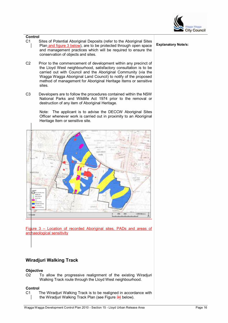
Wagga Wagga Development Control Plan 2010 - Section 15 - Lloyd Urban Release Area Page 16
Control C1 Sites of Potential Aboriginal Deposits (refer to the Aboriginal Sites
Plan and figure 3 below), are to be protected through open space and management practices which will be required to ensure the conservation of objects and sites.
C2 Prior to the commencement of development within any precinct of the Lloyd West neighbourhood, satisfactory consultation is to be carried out with Council and the Aboriginal Community (via the Wagga Wagga Aboriginal Land Council) to notify of the proposed method of management for Aboriginal Heritage Items or sensitive sites.
C3 Developers are to follow the procedures contained within the NSW National Parks and Wildlife Act 1974 prior to the removal or destruction of any item of Aboriginal Heritage.
Note: The applicant is to advise the DECCW Aboriginal Sites Officer whenever work is carried out in proximity to an Aboriginal Heritage Item or sensitive site.
Figure 3 – Location of recorded Aboriginal sites, PADs and areas of archaeological sensitivity
Explanatory Note/s:
Wiradjuri Walking Track
Objective O2 To allow the progressive realignment of the existing Wiradjuri
Walking Track route through the Lloyd West neighbourhood. Control C1 The Wiradjuri Walking Track is to be realigned in accordance with
the Wiradjuri Walking Track Plan (see Figure 34 below).
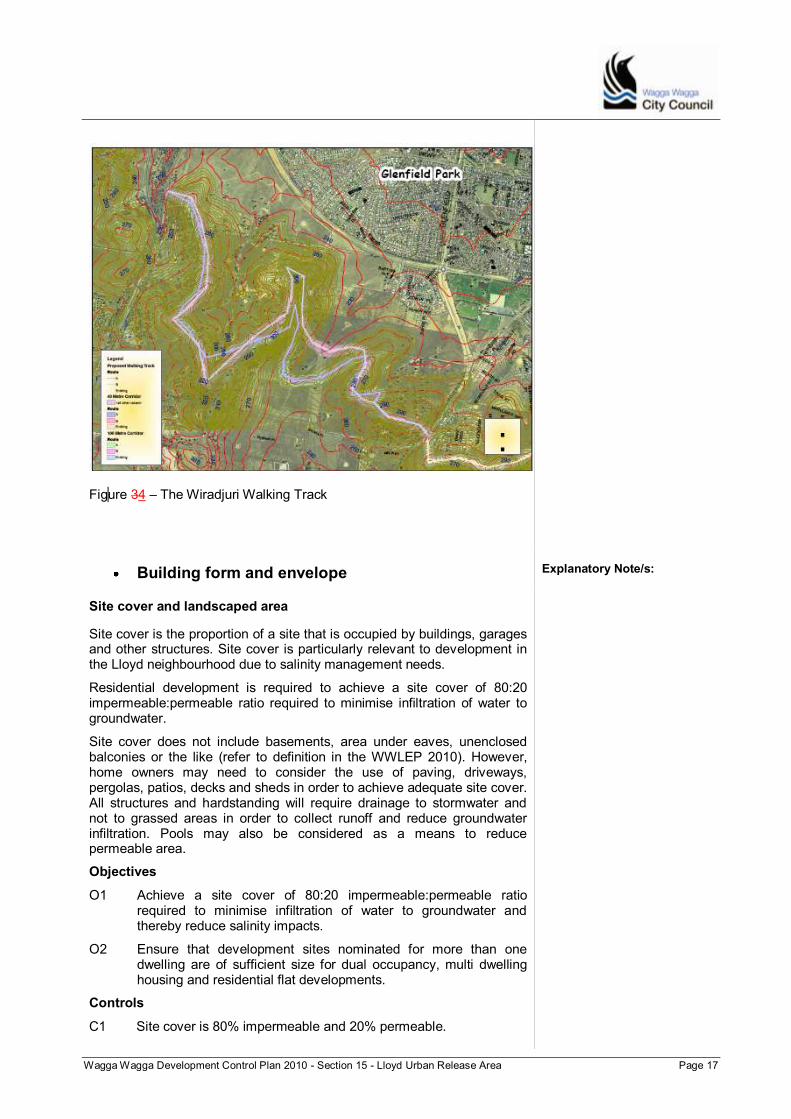
Wagga Wagga Development Control Plan 2010 - Section 15 - Lloyd Urban Release Area Page 17
Figure 34 – The Wiradjuri Walking Track
Building form and envelope
Explanatory Note/s:
Site cover and landscaped area
Site cover is the proportion of a site that is occupied by buildings, garages and other structures. Site cover is particularly relevant to development in the Lloyd neighbourhood due to salinity management needs.
Residential development is required to achieve a site cover of 80:20 impermeable:permeable ratio required to minimise infiltration of water to groundwater.
Site cover does not include basements, area under eaves, unenclosed balconies or the like (refer to definition in the WWLEP 2010). However, home owners may need to consider the use of paving, driveways, pergolas, patios, decks and sheds in order to achieve adequate site cover. All structures and hardstanding will require drainage to stormwater and not to grassed areas in order to collect runoff and reduce groundwater infiltration. Pools may also be considered as a means to reduce permeable area.
Objectives
O1 Achieve a site cover of 80:20 impermeable:permeable ratio required to minimise infiltration of water to groundwater and thereby reduce salinity impacts.
O2 Ensure that development sites nominated for more than one dwelling are of sufficient size for dual occupancy, multi dwelling housing and residential flat developments.
Controls
C1 Site cover is 80% impermeable and 20% permeable.
Wagga Wagga Development Control Plan 2010 - Section 15 - Lloyd Urban Release Area Page 18
Large Lot Residential and Rural Residential Development
Lots proposed to be used for large lot residential purposes require additional setback controls. Objectives
O1 To protect the visual amenity of the neighbourhood as well as existing vegetation.
Controls C1 The minimum setback for local roads is 10 metres for allotments in a
rural residential zone. C2 Building envelopes shall be nominated on all lots within the R5
Large Lot Residential zone. No building envelope shall encroach on any of the following: o Existing or proposed service easements, o An area that will require the removal of existing trees, o Setbacks identified for the purposes of noise buffering, o Land situated above the 280 metre AHD contour, unless the
building envelope can be serviced with reticulated water and individual approval for each envelope has been obtained from the water supply authority in this regard,
o Land within 10 metres of the front boundary of the allotment or land within 10 metres of another building envelope, or
o Bushfire Prone land.
Explanatory Note/s:
Development in the Lloyd Business Centre
The Lloyd local centre will support a range of retail and business activities to serve the Lloyd area. Developments should seek to integrate the local centre with, and complement the adjoining land uses, providing pedestrian friendly access routes, and active shop fronts to the streets.
Objectives
O1 Support the ongoing viability of local centres.
Controls
C1 Design to provide an active address to the adjoining residential precinct – avoid blank and unarticulated walls, consider outdoor dining areas or uses that encourage interaction with the street environment.
C2 Setbacks, building design and siting – locate building bulk to ensure acceptable setbacks to any adjoining residential land. A landscaped buffer may be required.
C3 The location of vehicle entrance and exit points is to minimise disturbance to the functioning of adjoining roads, and avoid directing additional traffic through residential precincts.
C4 Design and location of loading and unloading facilities away from residential properties close to the site and provide adequate screening.
C5 Provide facilities for bike parking.
Also refer to Part D, Section 10 of the WWDCP 2010.
Wagga Wagga Development Control Plan 2010 - Section 15 - Lloyd Urban Release Area Page 19
Appendices
Lloyd (Salinity Management ) Masterplan STAGE 1 (courtesy of EA Systems P/L)
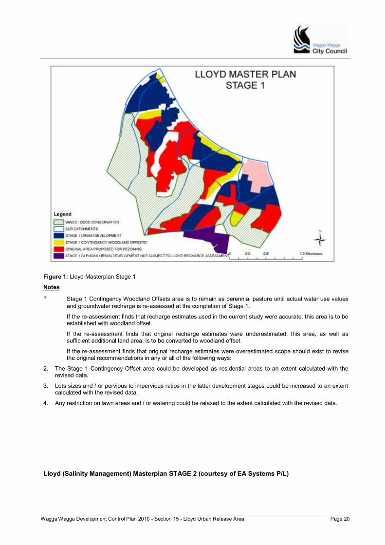
Wagga Wagga Development Control Plan 2010 - Section 15 - Lloyd Urban Release Area Page 20
Figure 1: Lloyd Masterplan Stage 1
Notes
* Stage 1 Contingency Woodland Offsets area is to remain as perennial pasture until actual water use values
and groundwater recharge is re-assessed at the completion of Stage 1.
If the re-assessment finds that recharge estimates used in the current study were accurate, this area is to be established with woodland offset.
If the re-assessment finds that original recharge estimates were underestimated; this area, as well as sufficient additional land area, is to be converted to woodland offset.
If the re-assessment finds that original recharge estimates were overestimated scope should exist to revise the original recommendations in any or all of the following ways:
2. The Stage 1 Contingency Offset area could be developed as residential areas to an extent calculated with the revised data.
3. Lots sizes and / or pervious to impervious ratios in the latter development stages could be increased to an extent calculated with the revised data.
4. Any restriction on lawn areas and / or watering could be relaxed to the extent calculated with the revised data.
Lloyd (Salinity Management) Masterplan STAGE 2 (courtesy of EA Systems P/L)
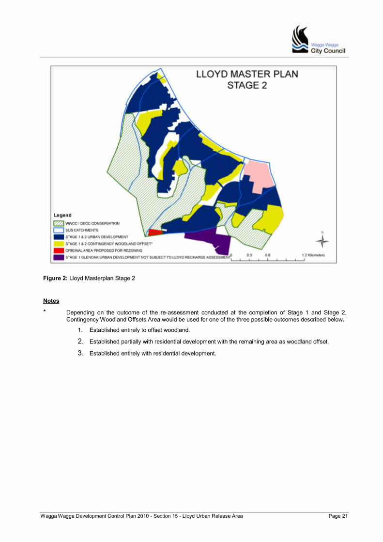
Wagga Wagga Development Control Plan 2010 - Section 15 - Lloyd Urban Release Area Page 21
Figure 2: Lloyd Masterplan Stage 2
Notes
* Depending on the outcome of the re-assessment conducted at the completion of Stage 1 and Stage 2,
Contingency Woodland Offsets Area would be used for one of the three possible outcomes described below.
1. Established entirely to offset woodland.
2. Established partially with residential development with the remaining area as woodland offset.
3. Established entirely with residential development.