SENSUM Earth Observation Tools Medium Resolution...
15
SENSUM Earth Observation Tools Medium Resolution algorithms USER MANUAL Prepared by Daniele De Vecchi (Università degli Studi di Pavia) [email protected] Issue 1 Revision 0 Date of Issue March 2016 Status Final
Transcript of SENSUM Earth Observation Tools Medium Resolution...

SENSUM Earth Observation Tools Medium Resolution algorithms
USER MANUAL
Prepared by Daniele De Vecchi (Università degli Studi di Pavia) [email protected]
Issue 1
Revision 0
Date of Issue March 2016
Status Final

Contents
Contents ............................................................................................................................................................ 2
List of acronyms ................................................................................................................................................. 3
Document Purpose ............................................................................................................................................ 4
SENSUM Earth Observation tools ...................................................................................................................... 5
G-POD integration ............................................................................................................................................. 7
Stack Satellite ................................................................................................................................................ 7
Unsupervised Change Detection ................................................................................................................... 8
Create a SENSUM Stack Satellite task ............................................................................................................... 9
Check and download the results ..................................................................................................................... 11
Results interpretation ...................................................................................................................................... 13

List of acronyms
ACRONYM DESCRIPTION
MR Medium Resolution
HR High Resolution

Document Purpose
Purpose of this document is to provide a concise user manual related to the version of the SENSUM Earth
Observation tools implemented into the G-POD infrastructure.
This manual is addressed to people familiar with interpretation of medium resolution optical satellite
imagery.

SENSUM Earth Observation tools
EO-based exposure and vulnerability proxies can be defined at different spatial levels. Extension and outline
of a built-up area, for example, is a valuable piece of information when assessing exposure to various natural
risks on a vast area. Zooming into the urban areas, other proxies can be defined like buildings regularity and
density, height, shape etc. Different open-source C and Python libraries are already available for image
processing and geospatial information handling (e.g. OrfeoToolbox, OpenCV and GDAL) providing basic
processing tools, producing results that reach a point located one step behind the exposure target. Therefore,
it is of significant importance to provide end-users with a set of tools based on simple work flows capable of
returning information at a higher level, in other words to “include the last mile”.
The research group at the University of Pavia developed a set of python algorithms, integrating low-level
image processing techniques with exposure-oriented workflows. This set of tools is available as QGIS plugin1
and source code2. Details related to each function can be found on the online SENSUM EO tools user guide3.
Following, the complete list of algorithms including a brief explanation of each algorithm and the resolution
the algorithms can focus on (medium or high resolution).
Table 1. List of algorithms available through the QGIS plugin
ICON NAME DESCRIPTION MR/HR
Pan-sharpening Pan-sharpening algorithm from OrfeoToolbox. MR and HR
Classification Unsupervised/Supervised classification from OrfeoToolbox. MR and HR
Segmentation (including optimizer option)
Segmentation algorithms from OrfeoToolbox, TerraAIDA (InterImage) and Skimage (python library).
MR and HR
Features Computation of spectral and textural features from segments. MR and HR
Co-Registration
Co-registration algorithm designed for medium resolution. SURF and FFT alternatives are included. While services of Open CV library are used in our approach, the FFT algorithm comes from Numpy (python library).
MR
Stack satellite Stack satellite workflow including co-registration and built-up extraction with 4 different methodologies.
MR
Unsupervised change detection
Automatic analysis of the outcome of the object-based built-up area extraction algorithms.
MR
1 https://plugins.qgis.org/plugins/sensum_eo_tools/ 2 https://github.com/SENSUM-project/sensum_rs_qgis 3 http://ldt.unipv.it/sensum-docs/
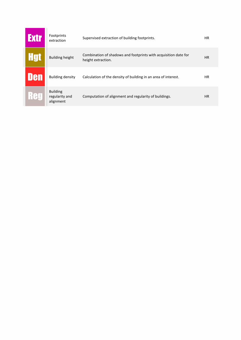
Footprints extraction
Supervised extraction of building footprints. HR
Building height Combination of shadows and footprints with acquisition date for height extraction.
HR
Building density Calculation of the density of building in an area of interest. HR
Building regularity and alignment
Computation of alignment and regularity of buildings. HR

G-POD integration
From the set of algorithms proposed before, the MR-oriented workflows have been chosen to be integrated
as G-POD service. The idea is to take advantage of the direct link with the Landsat and Sentinel catalogues.
NOTE: Landsat and Sentinel-2 data cannot be processed together.
Stack Satellite The processing workflow “backbone” is unchanged in respect of the QGIS plugin. Major adjustments have
been carried out in order to parallelize tasks and take advantage of the available worker nodes. Details
related to the implementation can be found in De Vecchi et al., 20164.
5 different methods are integrated to extract built-up areas from MR imagery:
Built-up Index method is based on an index computed using green, NIR and IR bands; the result is a
raster layer called “built_up_index.tif” with 5 bands (SAVI, NDVI, NDBI, MNDWI and BUILT_UP). The
built-up area can be extracted by applying a threshold over the last band. The same raster layer is
also used as input for the segmentation (see Dissimilarity method and PCA OB method).
PCA index method is a combination of PCA bands; the result is a raster layer called “pca_index.tif”
with 1 band related to the computed index. The built-up area can be extracted by applying a
threshold.
PCA classification method is the result of an unsupervised classification with PCA bands as input. The
built-up area usually corresponds to one or two classes.
PCA OB method5 is the combination of PCA bands averaged within segments computed over
“built_up_index.tif” from the most recent input year. Segments are then classified using an
unsupervised approach.
Dissimilarity method6 is based on the computation of the dissimilarity texture over the area of
interest and the consequent combination with segments. The outcome is classified using an
unsupervised classification.
All the methods present above are available as input parameters along with:
Cloud cover threshold: percentage of cloud cover allowable. Data with cloud cover exceeding this
value will not be processed.
Segmentation parameters [spatial radius, range radius, threshold, max iterations, min size]: input
parameters of the ‘Meanshift’ segmentation. Check the Orfeo Toolbox cookbook for more details
related to the algorithm7. Default values are provided.
Number of classes: number of classes for the unsupervised classification. Default value is 5.
DEM: use SRTM 30 meters DEM to mask mountains out.
4 D. De Vecchi, F. Dell’Acqua, R. Cuccu, C. Orrù and G. Rivolta, “Integration of tools for Large-Scale Exposure and Vulnerability assessment into the Remote Geospatial Processing Environment of the European Space Agency: an experience on “SENSUM Tools”, ESA Big Data from Space Conference (BiDS’16), Tenerife, Spain, 15-17 March 2016. 5 D. De Vecchi, M. Harb and F. Dell'Acqua, “A PCA-based hybrid approach for built-up area extraction from Landsat 5, 7 and 8 datasets”, Geoscience and Remote Sensing Symposium (IGARSS), 2015 IEEE International, Milan, 2015, pp. 1152-1154. doi: 10.1109/IGARSS.2015.7325975 6 M. Harb, D. De Vecchi and F. Dell'Acqua, “Automatic hybrid-based built-up area extraction from Landsat 5, 7, and 8 data sets”, Urban Remote Sensing Event (JURSE), 2015 Joint, Lausanne, 2015, pp. 1-4. doi: 10.1109/JURSE.2015.7120475 7 https://www.orfeo-toolbox.org/CookBook/CookBooksu127.html#x159-9680004.9.8

Unsupervised Change Detection TO BE IMPLEMENTED SOON

Create a SENSUM Stack Satellite task
1. Connect to the following website: http://gpod.eo.esa.int/
2. Log into the G-POD portal using your EO-SSO Login information
3. Click on ‘Land’ and then jump to the second page or simply type ‘sensum’ in the search bar
4. Click on the ‘SENSUM’ service
5. Define an AOI on the map (yellow rectangle), specifying also the time period
6. Select the catalogue to query (‘LANDSAT 8 L1GT’, ‘LANDSAT 8 L1T’, ‘LANDSAT-7 ETM+ GTC’,
‘SENTINEL-2 MSI L1C’)
7. Click on the ‘Query’ button
8. From the provided list, select the data to be processed (CTRL+click)
a. [Suggestion] try to select data with homogeneous acquisition time covering the AOI
b. The algorithm automatically merges all the tiles necessary to fill the AOI
c. Multiple years can be selected and processed separately

9. Fill the parameters box
a. Cloud cover threshold: images with Cloud Cover exceeding these values will not be processed
b. Segmentation parameters: default values are provided
c. Number of classes: used as input of the unsupervised classification, default is 5
d. Select/deselect the methods to be applied
e. Select/deselect the DEM option (default is true)
10. Click ‘Save in Workspace’ if you want to add more datasets or check the parameters. Click ‘Process
it’ to start immediately the procedure.
11. Status of the process and other details can be checked by clicking on the ‘Workspace’ tab. The next
paragraph is dedicated to the ‘Workspace’ section.

Check and download the results
Information related to the status of the procedure can be found in the ‘Workspace’ section.
Click on caption name to explore the details

Press the ‘Jobs Information’ button

Results interpretation Every result can be downloaded and further refined using software like QGIS.
Built-up index method
PCA index method

PCA classification method
PCA OB method

Dissimilarity method

![LIBER V: De pronominum constructione. · [6] Post omnia supradicta ponitur iure coniunctio, cum per se nullum sensum sine supradictarum dictionum materia significare posset, ut et](https://static.fdocuments.in/doc/165x107/5e48b33899ef1f15933828b3/liber-v-de-pronominum-6-post-omnia-supradicta-ponitur-iure-coniunctio-cum-per.jpg)